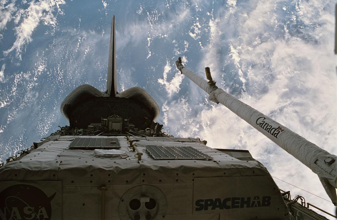
STS060-15-003 (3-11 Feb 1994) --- This 35mm frame shows the major payloads of the Space Shuttle Discovery's STS-60 mission, backdropped against clouds over the Atlantic Ocean. In the foreground is the SPACEHAB module, with the Wake Shield Facility (WSF) partially visible in its berthed position near the Orbital Maneuvering System (OMS) pods and the vertical stabilizer. Television cameras on the Remote Manipulator System (RMS) were being used for a survey of the cargo. Five NASA astronauts and a Russian cosmonaut went on to spend eight days in Earth orbit in support of the mission.
STS060-76-095 (3-11 Feb 1994) --- The ram side of the Wake Shield Facility (WSF) in the grasp of the Space Shuttle Discovery's Remote Manipulator System (RMS) arm is featured in this 70mm frame. Clouds over the Atlantic Ocean and the blackness of space share the backdrop for the picture. Five NASA astronauts and a Russian cosmonaut spent eight days in Earth orbit in support of the STS-60 mission.

STS060-93-043 (9 Feb 1994) --- BREMSAT, a 140 pound (63 kilogram) satellite, quickly leaves the cargo bay of the Space Shuttle Discovery. The 480 mm (19 inch) deployable satellite was built by the University of Bremen's Center of Applied Space Technology and Microgravity (ZARM) under sponsorship of the German Space Agency (DARA). A modified ejection system in one of the payload bay's getaway special (GAS) type canisters aided the STS-60 crew members in deploying the satellite toward the end of their eight-day mission in Earth orbit.
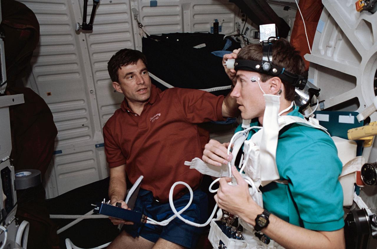
STS060-21-027 (3-11 Feb 1994) --- Astronaut Ronald M. Sega (left) and Russian cosmonaut Sergei K. Krikalev work on a joint U.S./Russian metabolic experiment on the Space Shuttle Discovery's middeck. A number of other U.S./Russian cooperative Detailed Supplementary Objectives (DSO) are included among the experiments conducted on the eight-day mission.
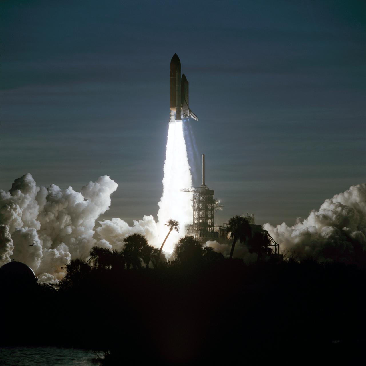
STS060-S-106 (3 Feb 1994) --- Palm trees are silhouetted in the foreground of this 70mm image as the Space Shuttle Discovery heads toward an eight-day mission in Earth orbit. Liftoff occurred as scheduled at 7:10 a.m. (EST), February 3, 1994. Aboard the spacecraft were astronauts Charles F. Bolden Jr., commander; Kenneth S. Reightler Jr., pilot; Franklin R. Chang-Diaz, payload commander; and N. Jan Davis and Ronald M. Sega, mission specialists, along with Russian cosmonaut Sergei K. Krikalev, also a mission specialist.
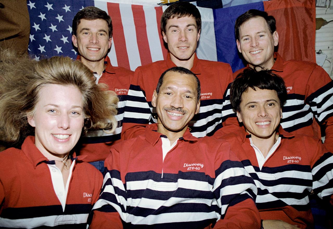
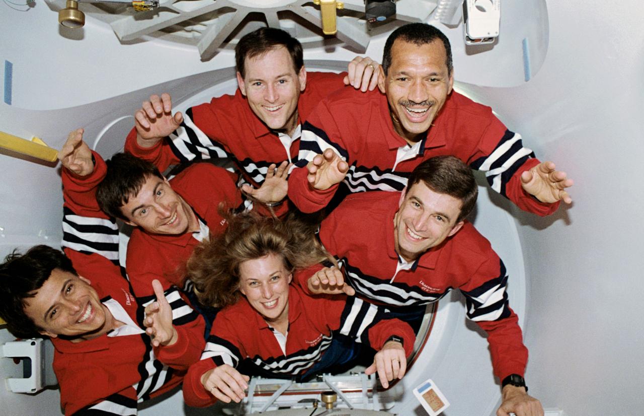
STS060-31-009 (3-11 Feb. 1994) --- The six-member STS-60 crew pose for the traditional in-flight crew portrait, with American and Russian flags forming the backdrop on the space shuttle Discovery’s middeck. Left to right (front row) are N. Jan Davis, Charles F. Bolden Jr. and Franklin R. Chang-Diaz; and (back row) Ronald M. Sega, Sergei K. Krikalev and Kenneth S. Reightler Jr. Photo credit: NASA or National Aeronautics and Space Administration
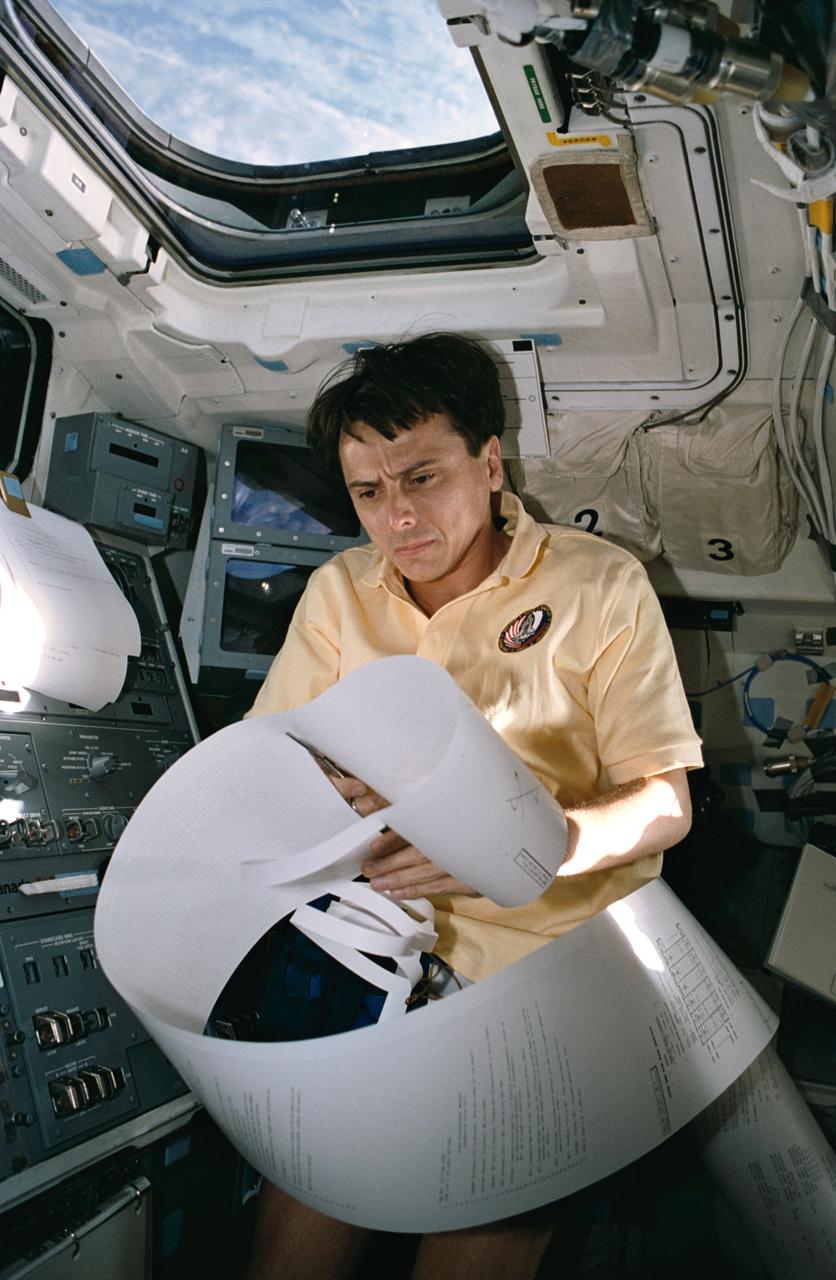
STS060-25-016 (6 Feb. 1994) --- On space shuttle Discovery?s aft flight deck, astronaut Franklin R. Chang-Diaz, STS-60 payload commander, begins to organize what was believed to be among the longest mail messages in shuttle history. Though early shuttle flights could brag of longer teleprinted messages, the Thermal Imaging Printing System?s day four correspondence, most of which is out of frame here, is record length for recent flights. Chang-Diaz joined four other NASA astronauts and a Russian cosmonaut for eight days aboard Discovery. Photo credit: NASA or National Aeronautics and Space Administration
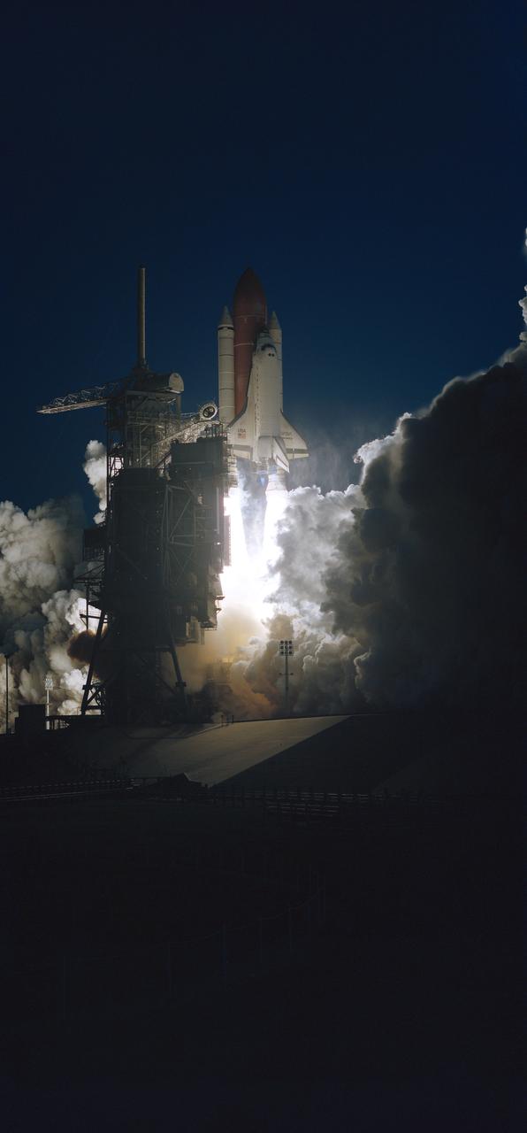
Launch Complex 39 is in partial darkness as the Space Shuttle Discovery heads toward an eight-day mission in Earth orbit. Liftoff occurred as scheduled at 7:10 a.m., February 3, 1994.
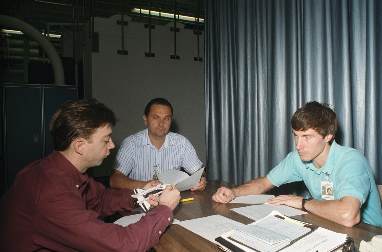
STS-60 Discovery, Orbiter Vehicle (OV) 103, Russian Mission Specialist Sergei Krikalev and Russian backup Mission Specialist Vladimir Titov work with Training Instructor Richard M. Davis (holding space shuttle model) prior to entering the Building 16 Systems Engineering Simulator (SES).
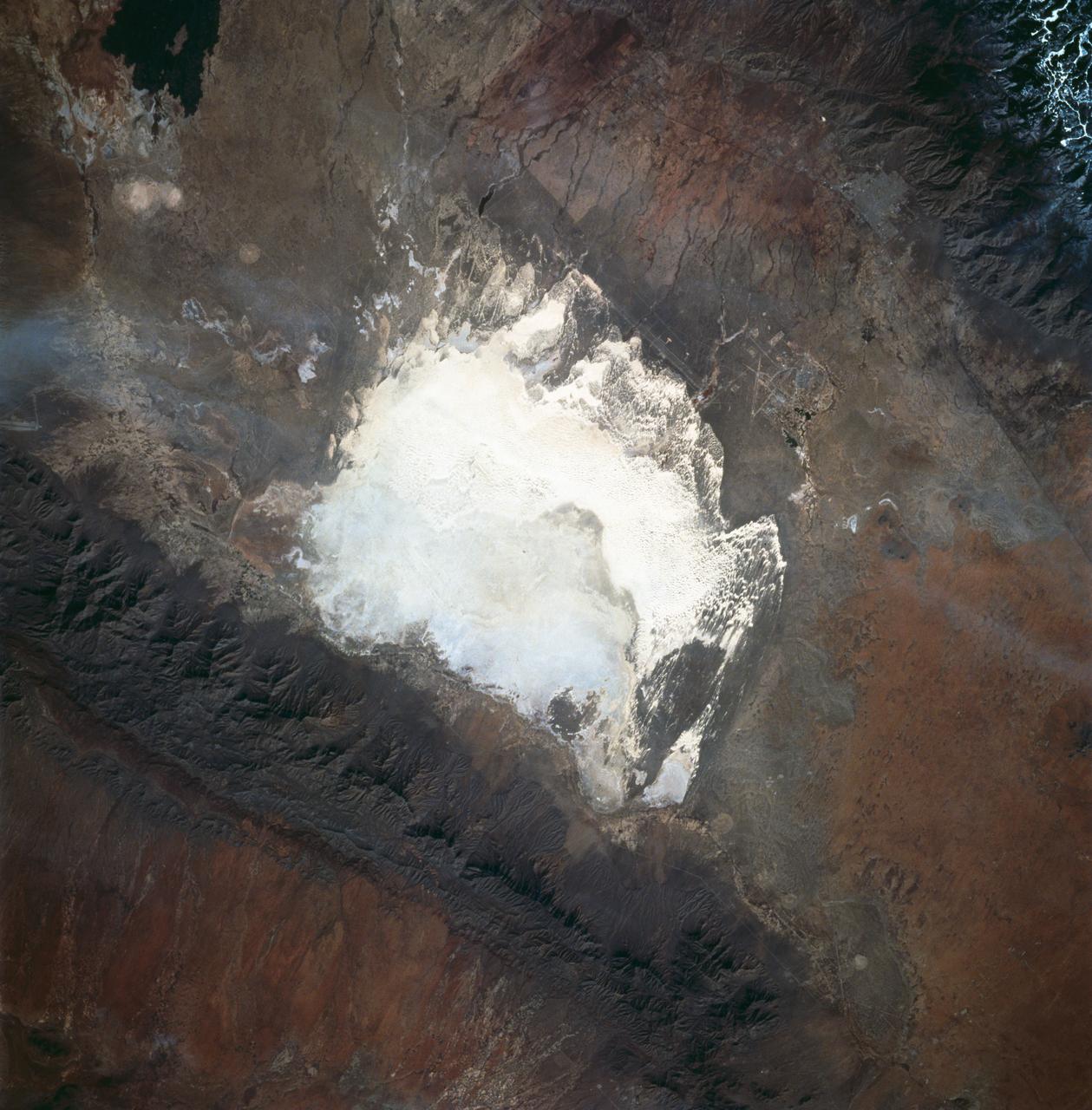
STS060-83-016 (3-11 Feb 1994) --- White Sands National Monument (Park) is easily recognized in the center of this near-vertical color photograph. White Sands is the world's largest gypsum dune field. It represents an alabaster sea that covers nearly 300 square miles. The National Park Service has the responsibility to preserve this unique feature, allowing the dune world to unfold in its natural environment, but without interference from humans. White Sands lies within a spectacular, oblong geological depression called the Tularosa Basin bounded by the Sacramento Mountains on the east and the San Andres Mountains on the west. Climatically the basin is a true desert, averaging less than 10 inches of rainfall per year. In terms of topographic relief the Sacramento Mountains attain elevations greater than 9,000 feet above sea level, while the San Andres Mountains on the west exceed altitudes of 8,000 feet. At the southwest corner of the White Sands is dry lake, Lucero. This lake is the lowest point in the Tularosa Basin at 3,900 feet. In terms of cultural features the city of Alamogordo (over 20,000 population) and Holloman Air Force Base can be seen with great clarity on this photograph. The area is accessible by highways U.S.70 & 82 from Las Cruces, New Mexico, and U.S.54 from El Paso, Texas.
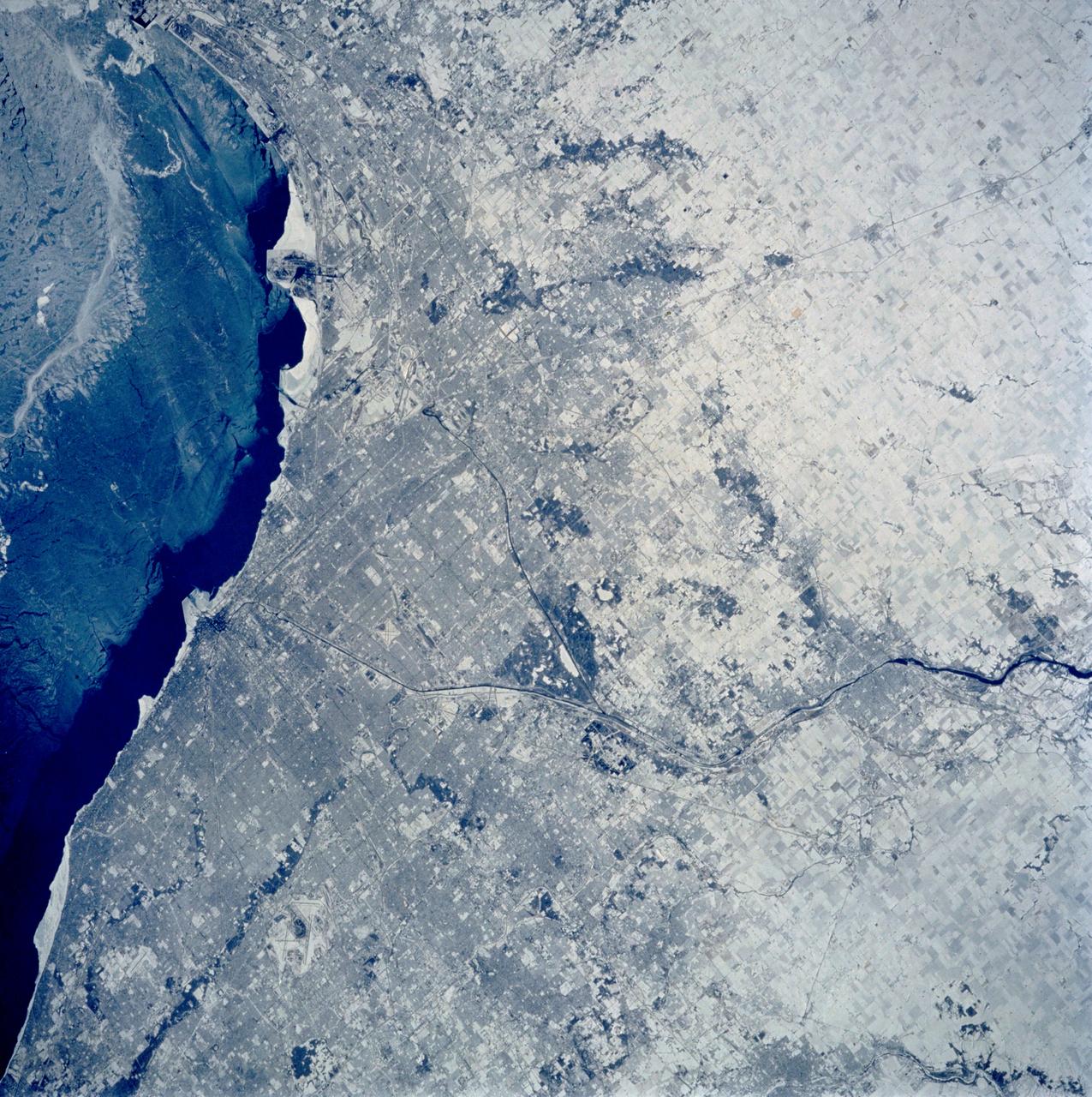
STS060-103-089 (3-11 Feb. 1994) --- The Chicago, Illinois area is in this northeast looking low oblique view obtained in February, 1994. Lake Michigan, a good portion covered with ice due to the very cold winter weather that has plagued this region since early December, 1993, can be seen to the east of the city. The Des Plaines river is visible traversing northeast to southwest through the center of the city. O'Hare International Airport and the Glenview Naval Air Station can be seen to the north of the Des Plaines River. Midway Airport is visible just to the south of the river. Chicago is a port of entry; a major Great Lakes port located at the junction of the St. Lawrence Seaway with the Mississippi River system; the busiest air center in the United States; and an important rail and highway transportation hub. Chicago is known for large grain mills and elevators, iron and steel works, steel fabrication plants, stockyards, meat-packing establishments, and printing and publishing houses. In the early days of settlement, the narrow watershed between Lake Michigan and the Des Plaines River (draining the Mississippi River through the Illinois River), offered an easy portage that led explorers like Father Marquette and Louis Joliet and others to the Great Central Plains. Fort Dearborn, a military post was established in 1803. By 1860, the railroad connected Chicago to the rest of the country and the city became a great mid-continent shipping and receiving center. In 1871, the city built of wood, was almost entirely destroyed by a great fire. After the fire, Chicago was built as a city of steel and stone. During the World's Colombian Exposition held in Chicago in 1893, the city became a leading architectural center. It was here during the Exposition that the skyscraper came into being. Chicago continues to lead the way in this type of architectural structure as is evidenced with the completion of the Sears Tower in 1974.
STS060-31-028 (3-11 Feb. 1994) --- Five NASA astronauts and a Russian cosmonaut squeeze through the tunnel which connects the shirt-sleeve environments of the space shuttle Discovery and the SPACEHAB module. SPACEHAB is located in the spacecraft’s payload bay. Charles F. Bolden Jr., mission commander, is at upper right. Others, clockwise from the commander, are Ronald M. Sega and N. Jan Davis, both mission specialists; Franklin R. Chang-Diaz, payload commander; cosmonaut Sergei K. Krikalev, mission specialist; and Kenneth S. Reightler Jr., pilot. The six spent eight days in Earth orbit. Photo credit: NASA

STS060-87-087 (3-11 Feb 1994) --- Lake Baikal, in southeastern Siberia, is the largest freshwater lake in the world by volume, holding nearly 20 per cent of the world's fresh water. Lake Baikal is a biospheric reserve of high international interest to the global scientific community. It is home to some 600 endemic species, many found in no other location. This view shows the northern end of the lake, and was taken in the early morning with low sun highlighting the mountain ranges rimming the lake basin. Pristine forests surround the lake, although heavy logging is evident in other photography of the central and southern portions of the lake. Another unique aspect of Lake Baikal is the existence of the world's only known freshwater hydrothermal springs. The fault system which bounds the lake allows fluids to circulate deep into the Earth and resurface as hot springs around and in the lake. Russian and American scientists are using the Shuttle photography to examine the relationship of the lake's ice cover to areas of known hydrothermal activity. Thus Lake Baikal has been and continues to be a high-priority site for photography from space from both the Space Shuttle and the Russian Space Station MIR.
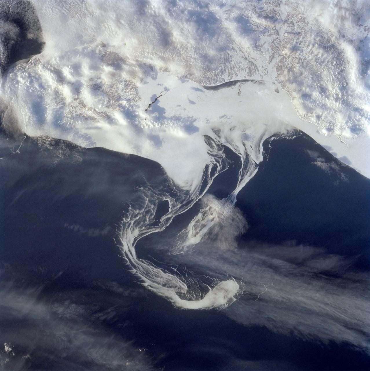
STS060-73-038 (3-11 Feb 1994) --- Pack ice is documented in this photograph along the coast of the Kamchatka Peninsula of Russia in Zaliv Ozernoj. Newly formed ice continually breaks away from the land and takes the form imposed by coastal currents. Detailed photographs of the ice provide information to scientists in both Russia and the united States about the location and fluctuation of ice edges, and how this new sea ice interacts with ocean and littoral currents. This information results in better ice warnings to shipping traffic and provides data points for long-range climate change research for both the Mission-To-Planet Earth and the Russian Priroda ("Nature") monitoring and assessment programs that are respectively coordinated by NASA and the Russian Academy of Sciences. This photography of ice development in the North Pacific, North Atlantic, the Southern Ocean, the Baltic and North Seas, and the Great Lakes is of great interest to the international scientific community. NASA scientists feel high-resolution analog and digital photography from the Space Shuttle and future craft can be a particularly important component in satisfying their data needs on both an operational and a long-term research basis.
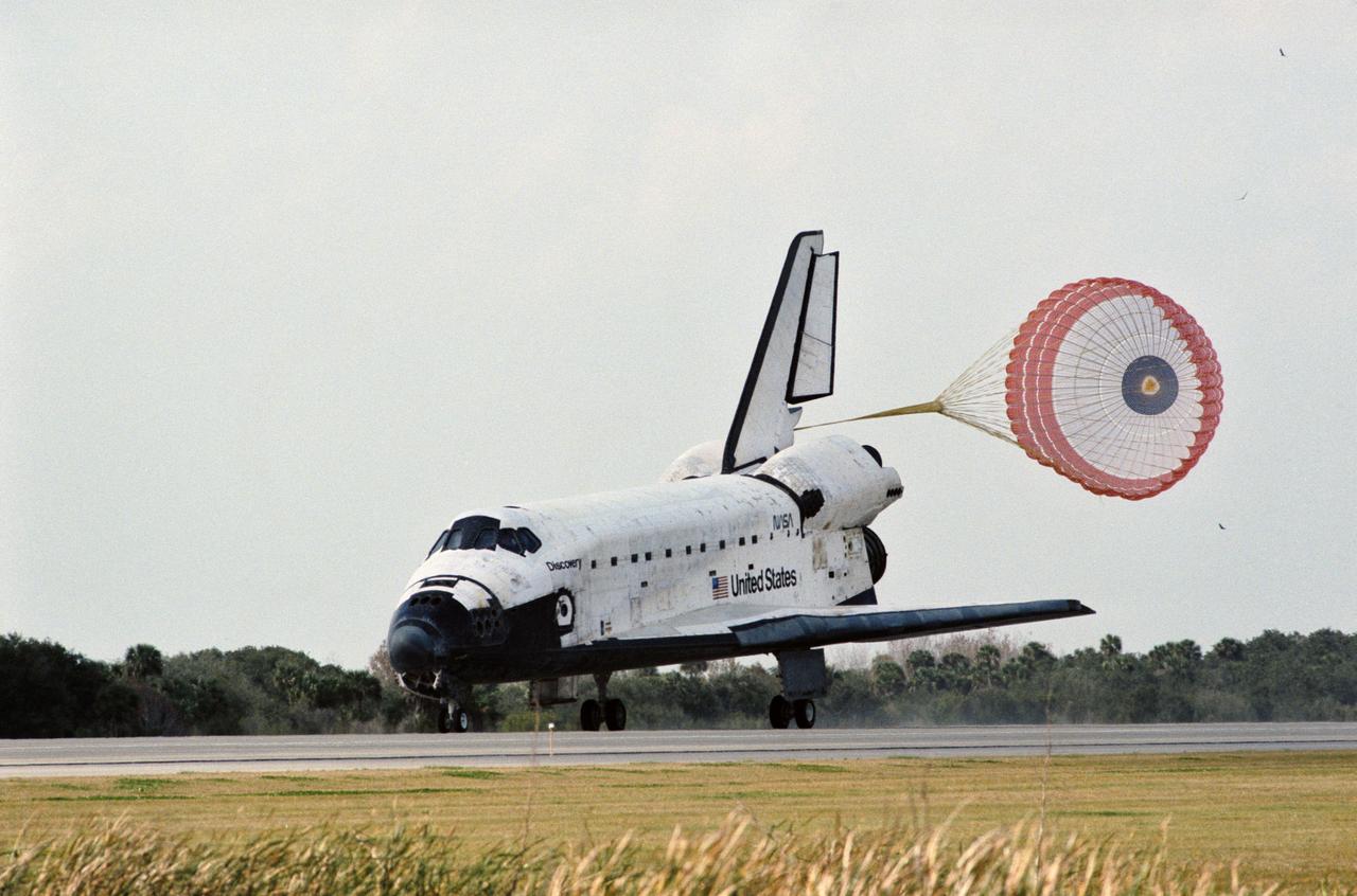
STS060-S-035 (11 Feb 1994) --- The drag chute for Space Shuttle Discovery is deployed on the Shuttle Landing Facility, marking an end to the eight-day STS-60 mission. Landing occurred at 2:19:22 p.m. (EST). Onboard were astronauts Charles F. Bolden Jr., Kenneth S. Reightler Jr., Franklin R. Chang-Diaz, N. Jan Davis and Ronald M. Sega along with Russian cosmonaut Sergei K. Krikalev.

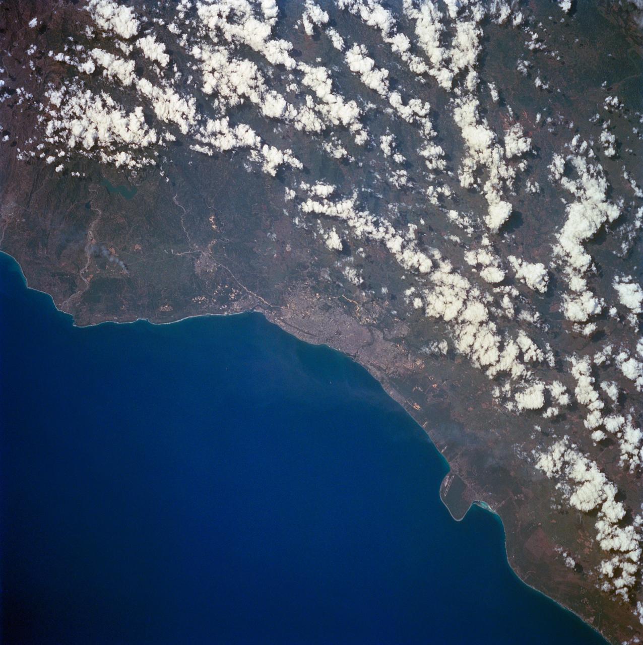
STS060-88-070 (3-11 Feb 1994) --- This view shows sunglint in the Strait of Gibralter. In this photograph a high pressure atmospheric system over the Iberian Peninsula has set the conditions for seeing a plankton bloom along the Moroccan coast in the Alboran Sea (Western Mediterranean) coastal counter current as well as illumining the influence of winds in the sunglint pattern near the Strait of Gibraltar. Where the water is ruffled from a wind gust, such as off Cadiz, Spain, the surface is less reflective and thus appears dark. A combination of the effects of the tide and the surface winds through the Strait of Gibraltar have created a unique sunglint pattern at the entrance of the Mediterranean. The Atlantic Ocean waters are flowing with the tide through the Strait of Gibraltar into the Mediterranean Sea and are probably smoothing out some of the smaller waves at the surface. The incoming tide generates internal waves as can be faintly seen in this photograph. The incoming relatively cooler, less dense Atlantic water flows over the warm, more saline Mediterranean water. As the tide moves into the Strait of Gibraltar it encounters the Camarinal Sill, which is like a cliff under the water, south of Camarinal Point, Spain. Internal waves are generated at this sill and they travel along the density boundary between the Atlantic water and the Mediterranean water masses. There is little evidence of the internal waves at the surface of the ocean. We can see them in spacecraft photography because of the sunglint which reflects off the different water layers in differential patterns. The internal waves also smooth out some of the bands of capillary waves at the surface. That is, the sun reflects more brightly from these smooth areas, showing the pattern of the underwater waves more prominently than do the surface waves. The Bay of Cadiz on the southwest coast of Spain, the Rock of Gibraltar, and the Moroccan coast are also beautifully illustrated in this photography. The focus for scientists, however, remains the high clarity and spatial resolution given by sunglint studies to physical phenomena in the ocean.
STS060-84-063 (3-11 Feb 1994) --- This is an excellent photograph of the coastal city of Santo Domingo on the Caribbean Sea. The airports including De las Americas International Airport are clearly seen. This photo illustrates the resolving power of the films. For example, two isolated smoke plumes are clearly seen each side of the city.
STS060-84-021 (3-11 Feb 1994) --- The Kennedy Space Center (KSC) and its partially cloud-covered environs were captured on 70mm by one of the STS-60 crew members during the eight-day mission. The Shuttle landing facility, on which Discovery landed February 11, 1994, visible at left center.
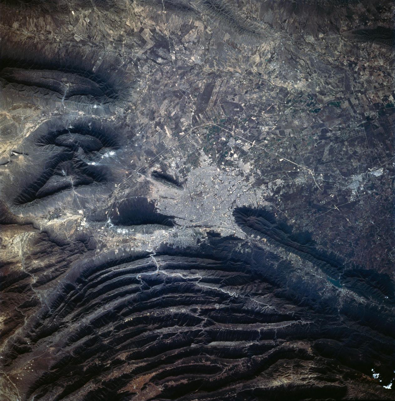
STS060-83-041 (3-11 Feb 1994) --- The large city of Monterrey, in northeastern Mexico, was founded at the edge between the Sierra Madre Oriental and the Rio Grande Embayment portion of the Gulf Coastal Plain. This location is analogous to the Fall Line along the United States eastern seaboard, but instead of lying along a stream at the head of navigation, Monterrey lies at the boundary between a well-watered mountain range and a semi-arid plain where irrigation is often necessary for successful agriculture. The mountains themselves are formed from folded limestone and shale beds; to the south of the city, beds are crumpled into tight folds. Around and north of the city, more open folds gradually give way to nearly flat-lying beds of the coastal plain. Because of the water and other resources such as shale and limestone to quarry and burn for cement, Monterrey early became a thriving industrial center. It is now one of Mexico's largest cities with a population of approximately 5 million. According to NASA geologists, the STS-60 photography of this area is the best that has been acquired during the past 32 years of space photography by the United States. Monterrey remains an area of high interest for future photography in order to assess the impact of urbanization in this area.
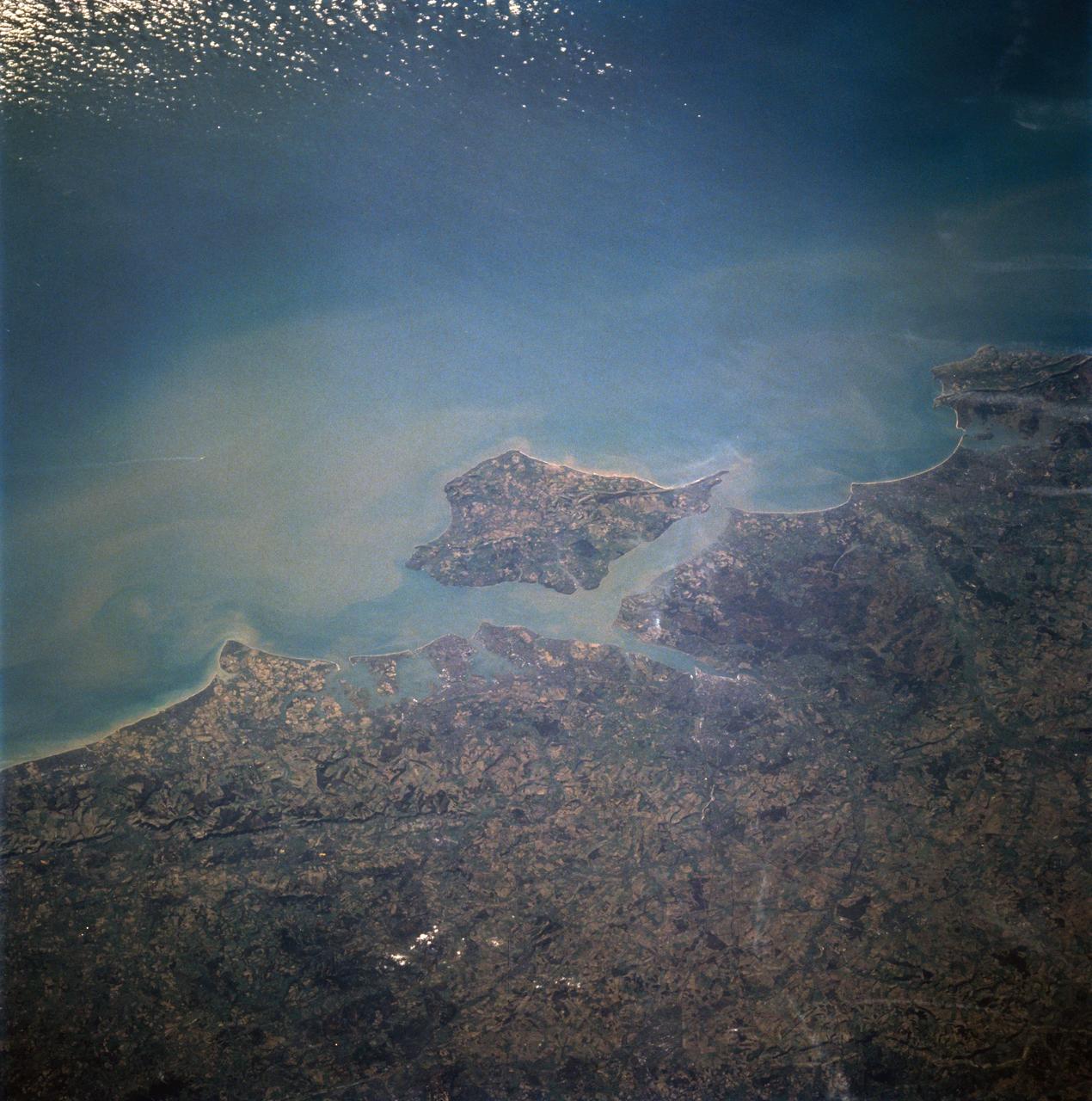
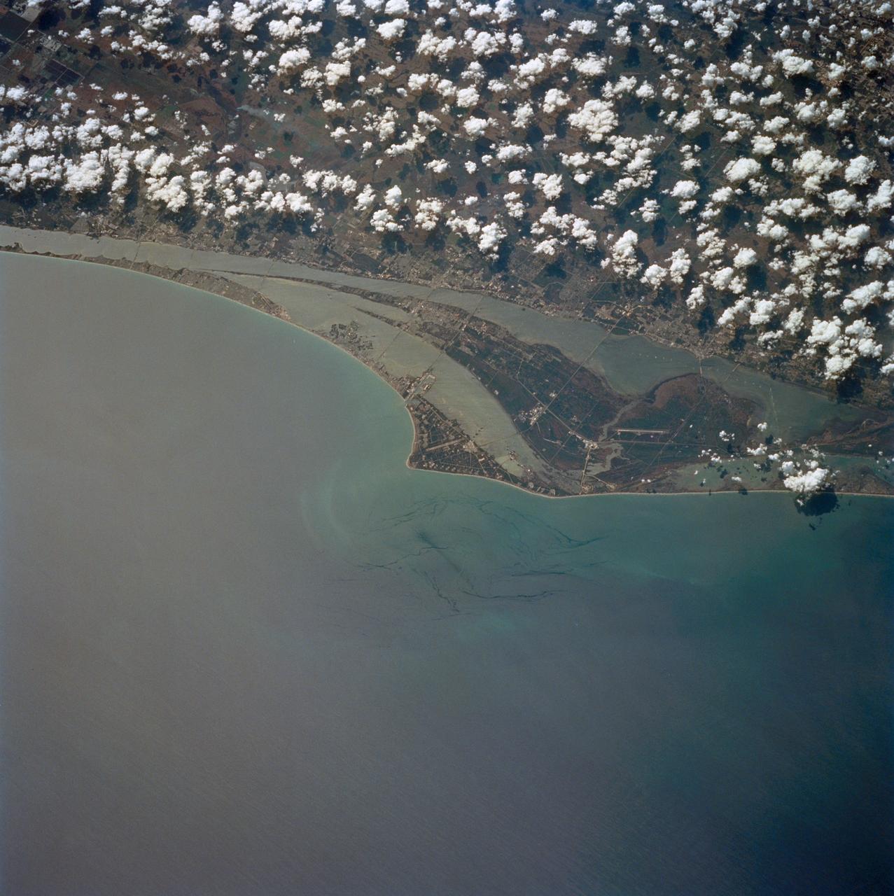
STS060-94-007 (3-11 Feb 1994) --- The Isle of Wight, over 380 square kilometers, is a diamond-shaped island located off the south coast of England. Separated from the mainland by The Solent, a narrow channel of water, the island is a popular resort area due to its scenery and mild climate. Sediment from English Lowland drainage systems, most notably the River Test, is visible entering The Solent and spilling into the English Channel. At the tip of the linear, northwestward inlet is the mouth of the Test and the city of Southampton, discernible as a small patch of lighter gray. Further east is a series of protected bays which are, from west to east: Portsmouth Harbour, Langstone Harbour, and Chichester Harbour. The city of Portsmouth is the location of Great Britain's chief naval station and arsenal. Portsmouth houses numerous ships of past and present glory. Two of the most notable vessels in Portsmouth are the 104-gun Victory, and the remains of the Mary Rose. The renowned HMS Victory, still carried on active duty rolls of the Royal Navy, and the acting Post Ship of the Royal Navy Base Commander, was built in 1765. The HMS Victory was severely damaged and dismasted in battle. A careful inspection of the original film will show the 175-foot long HMS Victory in this frame. According to NASA geologists it is extremely unusual for Portsmouth to be this cloud-free. It has been a site of some interest for many Space Shuttle missions during the past 10 years.
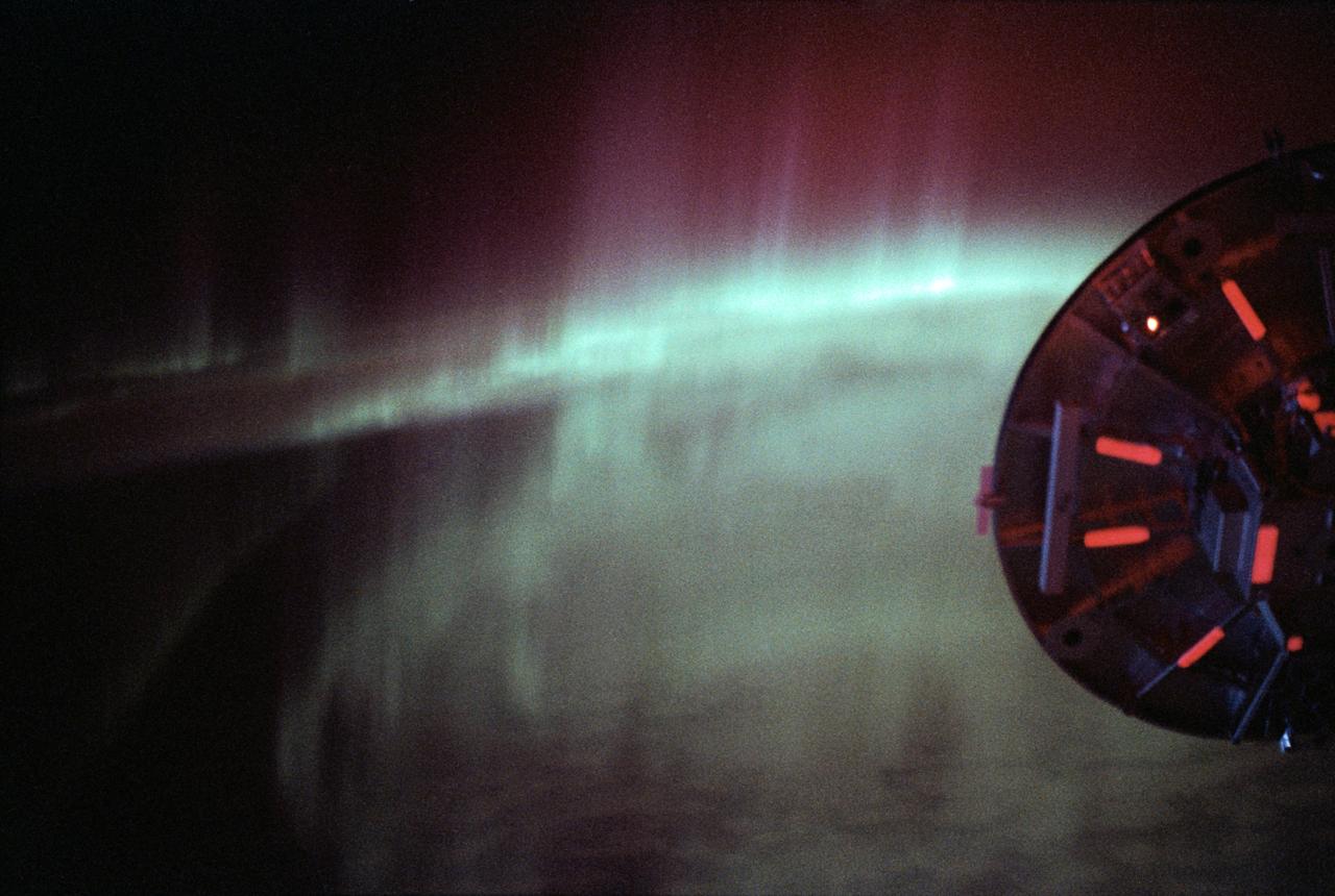
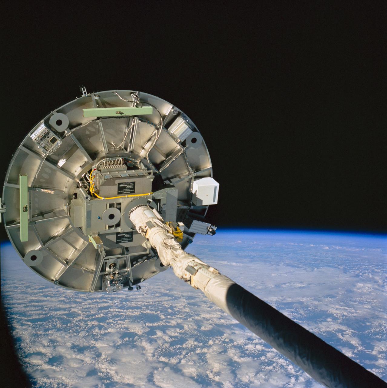
STS060-09-024 (3-11 Feb 1994) --- As the Space Shuttle Discovery flew over a point between New Zealand and Australia, one of the STS-60 crew members used a 35mm camera to capture this image featuring three-fourths of the disc of the Wake Shield Facility (WSF) back dropped against the Southern Lights. The WSF was in the grasp of the Remote Manipulator System (RMS) end effector (out of frame at right).
STS060-57-033 (3-11 Feb 1994) --- Astronaut Ronald M. Sega suspends himself in the weightlessness aboard the Space Shuttle Discovery's crew cabin, as the Remote Manipulator System (RMS) arm holds the Wake Shield Facility (WSF) aloft. The mission specialist is co-principal investigator on the WSF project.
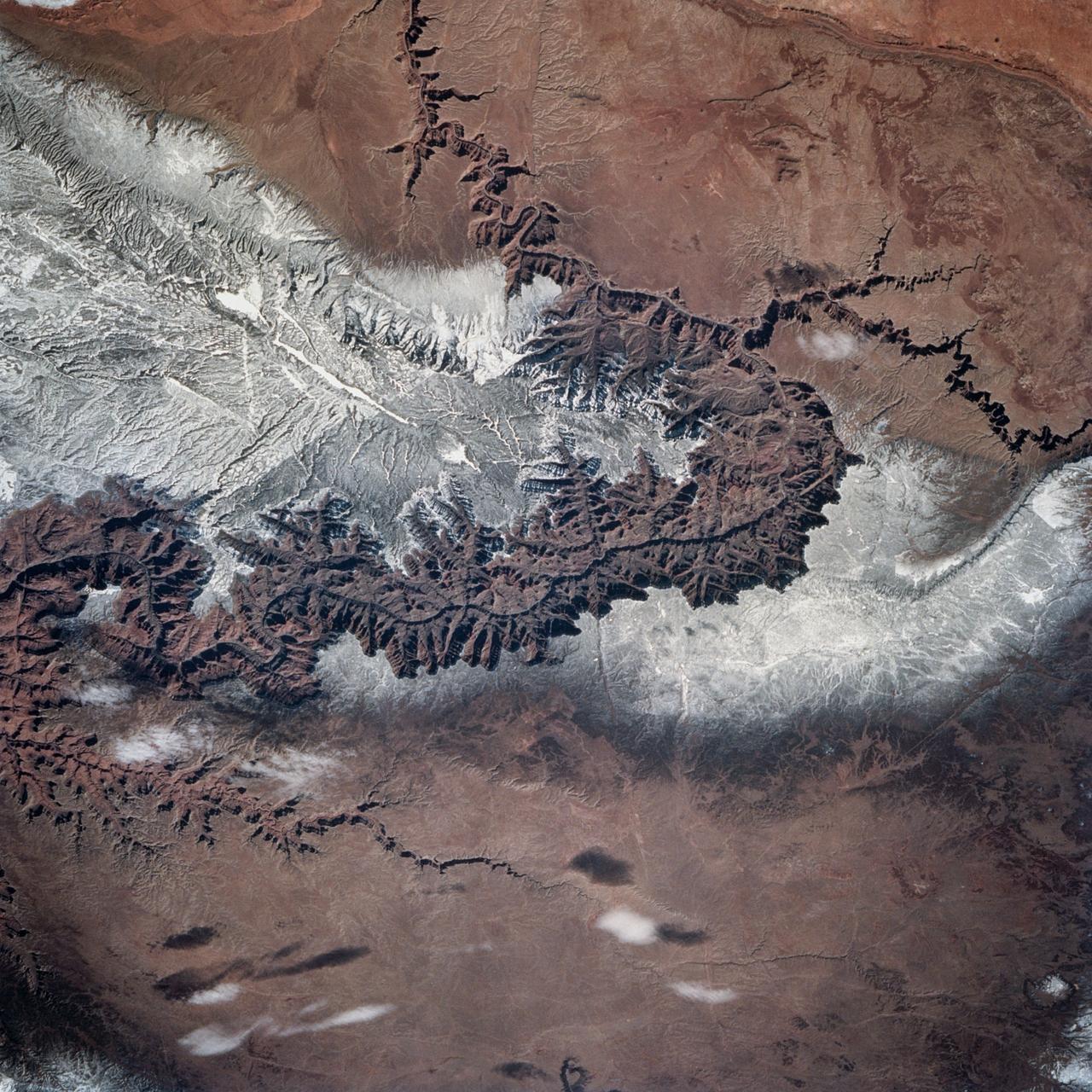
STS060-83-004 (3-11 Feb 1994) --- In this winter scene of the Grand Canyon of Arizona, the canyon is particularly well revealed because snow lies on the rims of the canyon, and exits mid-right; the Little Colorado River enters from the left, joining the Colorado just upstream of its big bend. Visitors to the South Rim can view the canyon in both the east-west and north-south reaches. The South Rim is closer to centers of transportation so that tourists mostly see the canyon from this area, that is from about 7,000 feet. The canyon floor lies at 2,000 feet in this sector. The most heavily snow covered area is the highest, reaching more than 9,000 feet (bottom right). Visitors see this protected area by hiking and mule and helicopter rides. The ecology of this part of the Colorado has been changed since the building of a lake upstream: river water is now derived from snow melt water from the bottom of the lake. This water is much colder than the water which used to flow through the canyon. According to NASA scientists, the view is unusual because the snow also reveals so well the higher country around the canyon, a swath stretching from bottom right to middle left of the view. This higher swath is an arch of uplifted rocks known as the Kaibab Plateau, raised vertically by tectonic forces in the recent geologic past. Despite this up parching, the Colorado River managed to maintain its course to the sea by cutting an ever deeper canyon into the Plateau. The white snow cover hides the fact that the Kaibab Plateau is thickly forested and thus appears dark green in summer, except in areas of clear-cutting. Since the Plateau reaches altitudes of 6 to 9,000 feet, it is both cooler and moister than the surrounding lower desert floor (top and bottom in this view) - where sparse vegetation and rocky country appear as brown colors. The zone of dark color running parallel to the snow line is all that can be seen of the pine forest on the south flanks of the Plateau.
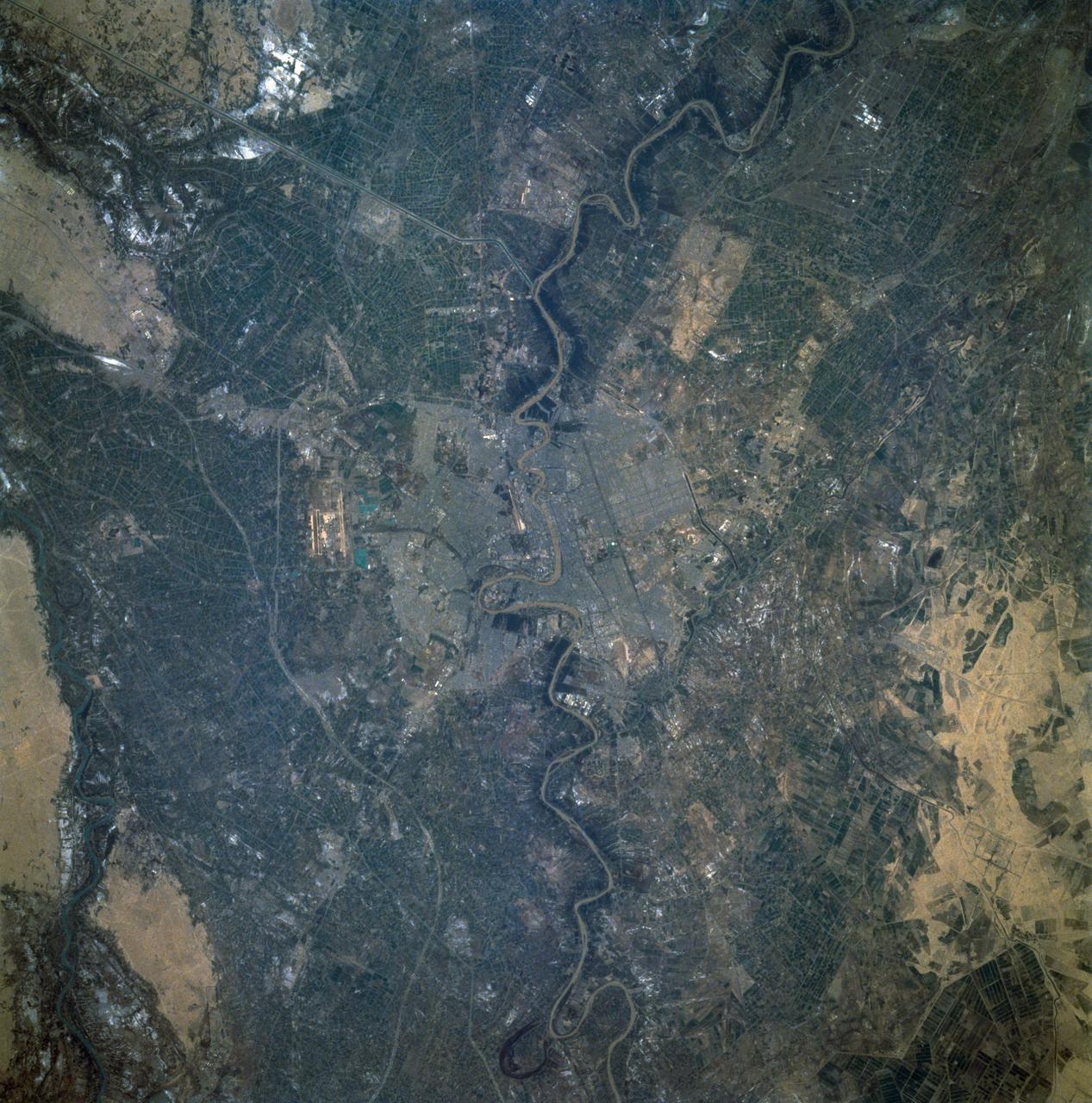
STS060-92-082 (3-11 Feb 1994) --- This cloud-free view is centered on the city of Baghdad, Iraq. Baghdad has had a reputation for scholarship and learning from ancient times in the Islamic world. Modern Baghdad is a city with a typical urban land use patterns. The color of Tigris river flowing through the city indicates the heavily sediment laden waters of the river. Agricultural land uses are evident in the surrounding areas of the city.
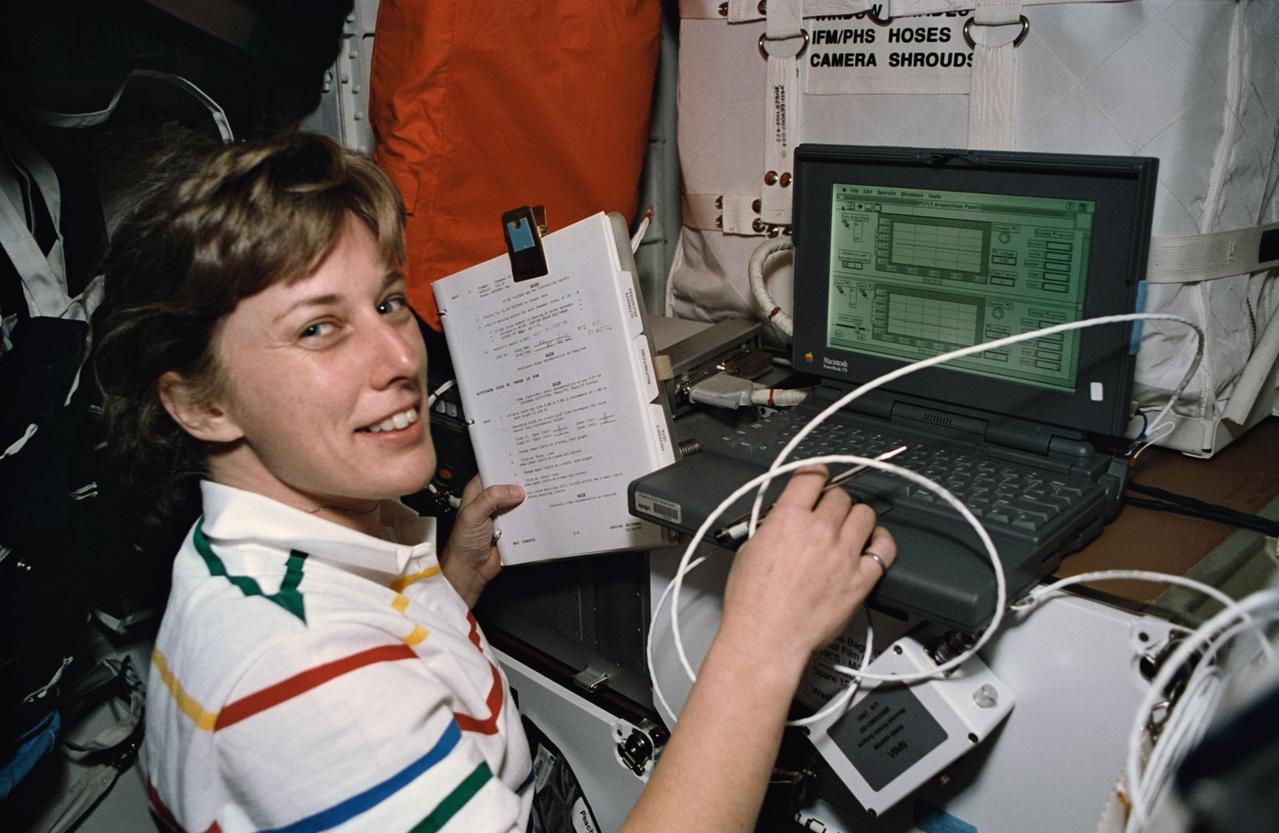
STS060-21-031 (3-11 Feb 1994) --- Using a lap top computer, astronaut N. Jan Davis monitors systems for the Commercial Protein Crystal Growth (CPCG) experiment onboard the Space Shuttle Discovery. Davis joined four other NASA astronauts and a Russian cosmonaut for eight days in space aboard Discovery.
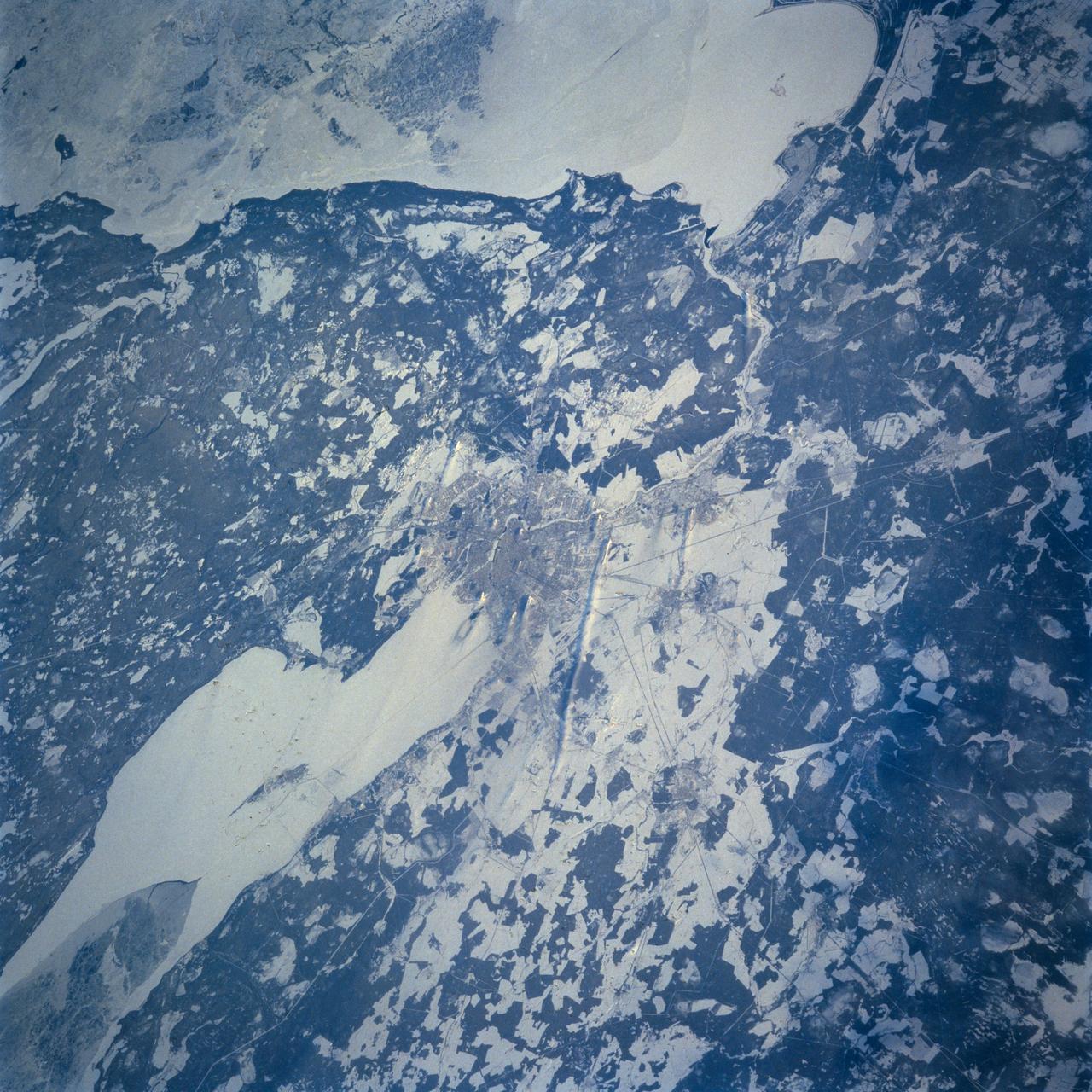
STS060-103-055 (3-11 Feb 1994) --- This wintertime photograph shows the large city of St. Petersburg Russia at the head of the Gulf of Finland. The city, built by Peter the Great, is situated in the former swampy delta of the Neva River which connects the large Lake Ladoga (the frozen white surface on the edge of the photograph) to the Gulf of Finland. An interesting feature of St. Petersburg which can be discerned in this photograph is the new storm surge barrier built from both sides of the Gulf of Finland out to the island of Kronstadt in the middle. This barrier, similar to that which was built on the Thames River south of London to protect it from storm surges out of the North Sea, was constructed to protect St. Petersburg from storm surges coming out of the Baltic Sea and being magnified by the topography and hydrography of the Gulf of Finland. Also visible as a thin line between Kronstadt and St. Petersburg is the ice-free shipping channel kept open much of the winter. Power plant plumes are also visible on the frame. St. Petersburg is the home of the Russian cosmonaut, Sergei Krikalev, who flew aboard the Space Shuttle Discovery during STS-60.
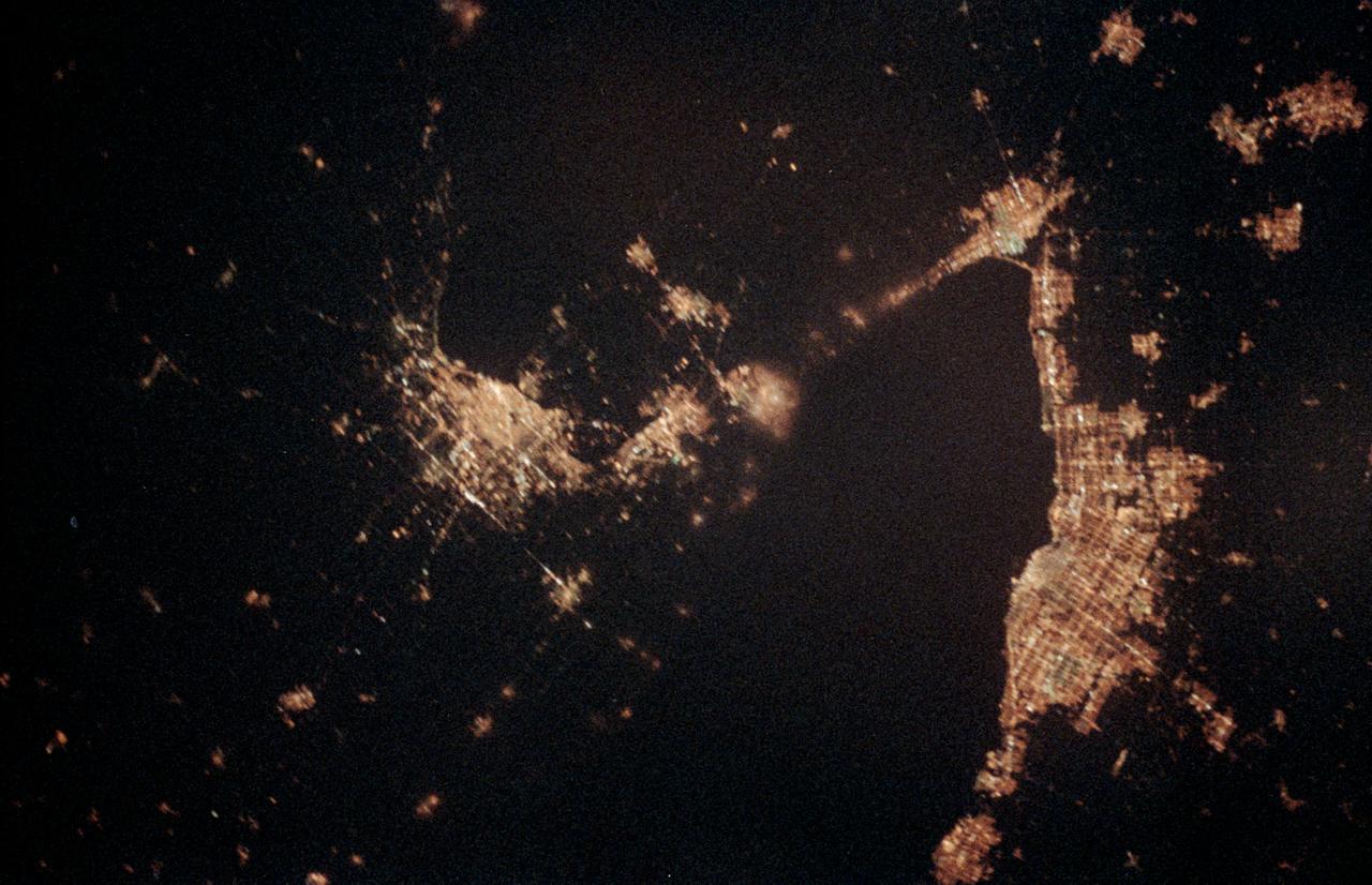
STS060-06-037 (3-11 Feb 1994) --- The city lights of Buffalo and Toronto outline the shores of the east end of Lake Erie and the west end of Lake Ontario in this night scene of western New York and southern Ontario. Between the two major cities are the cities of Niagara Falls, New York and Niagara Falls, Canada, which straddle the Niagara River just north of the actual falls. This photograph was taken with a special ASA-1600 film that is normally used for night-time photography of aurora, noctilucent clouds, biomass burning, and city lights.
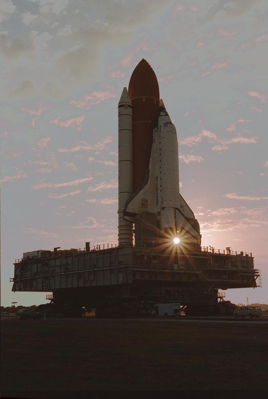
KENNEDY SPACE CENTER, FLA. -- Leaving the Vehicle Assembly Building for Launch Pad 39A on a crisp, clear winter day, the Space Shuttle Discovery makes the final Earth-bound leg of a journey into space. Once at the pad, two of the payloads for Discovery's upcoming flight, mission STS-60, will be installed. The Wake Shield Facility-1 and Get Away Special bridge assembly will be joining SPACEHAB-2 in the orbiter's payload bay. Liftoff of the first Space Shuttle flight of 1994 is currently targeted for around Feb. 3
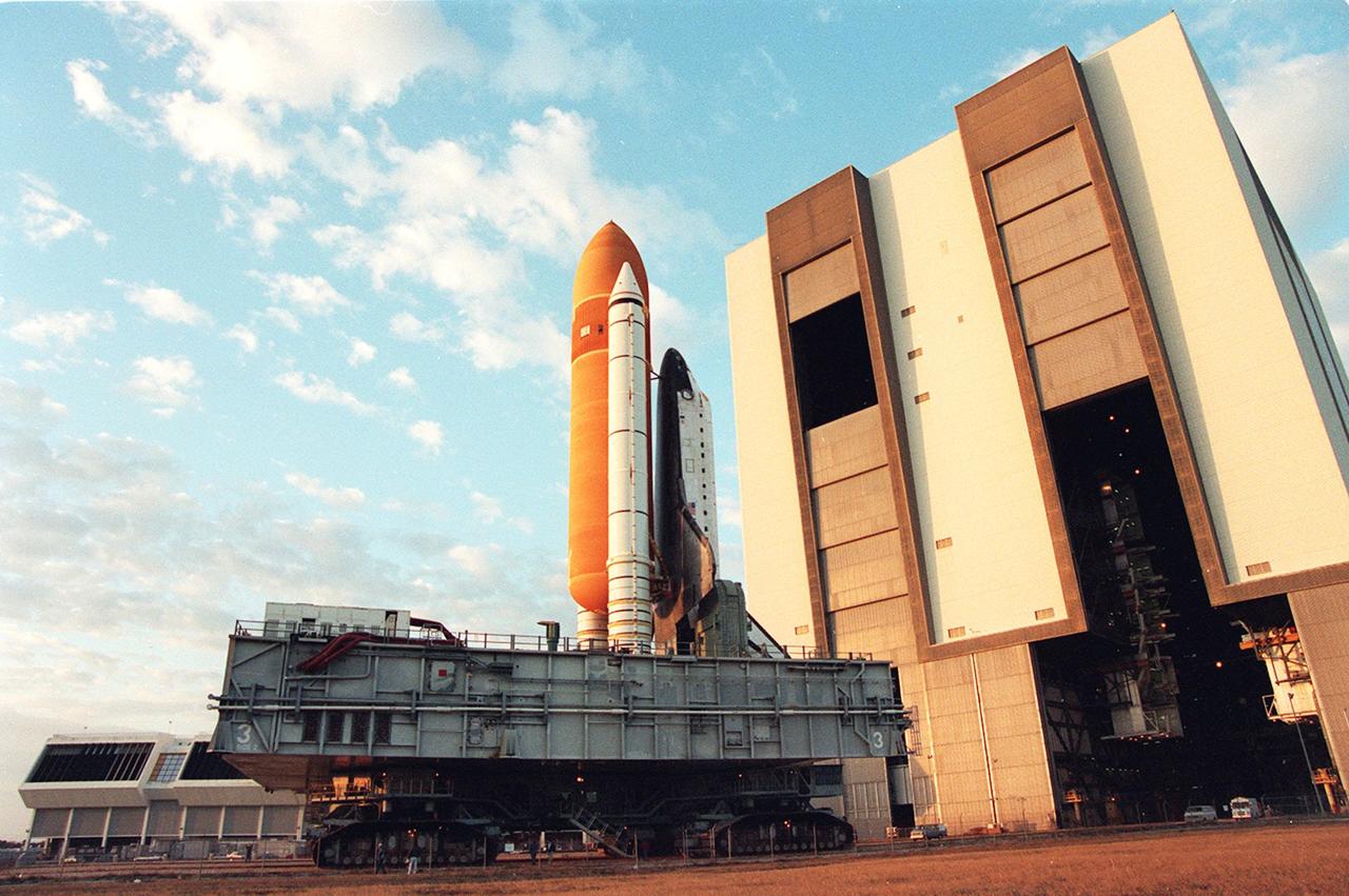
KENNEDY SPACE CENTER, FLA. -- Leaving the Vehicle Asembly Building for Launch Pad 39A on a crisp, clear winter day, the Space Shuttle Discovery makes the final Earth-bound leg of a journey into space. Once at the pad, two of the payloads for Discovery's upcoming flight, mission STS-60, will be installed. The Wake Shield Facility-1 and Get Away Special bridge assembly will be joining SPACEHAB-2 in the orbiter's payload bay. Liftoff of the first Space Shuttle flight of 1994 is currently targeted for around Feb. 3
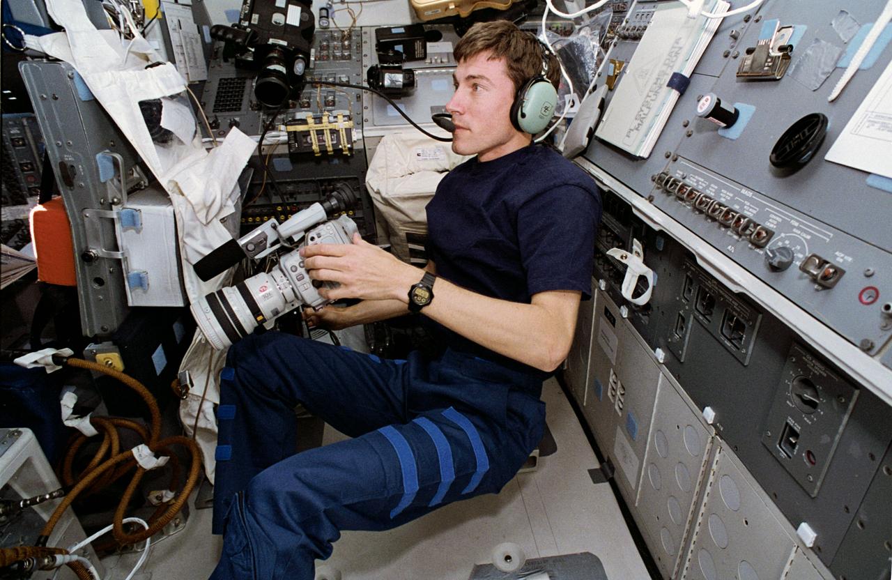
STS60-29-009 (10 Feb 1994) --- On the Space Shuttle Discovery's aft flight deck, Russian cosmonaut Sergei K. Krikalev prepares for one chore while performing another. Using the Shuttle Amateur Radio Experiment (SAREX) gear, the mission specialist was talking with students in Maine. He holds a camcorder, which was later called into action to record inflight activities. Krikalev joined five NASA astronauts for eight days in space aboard Discovery.
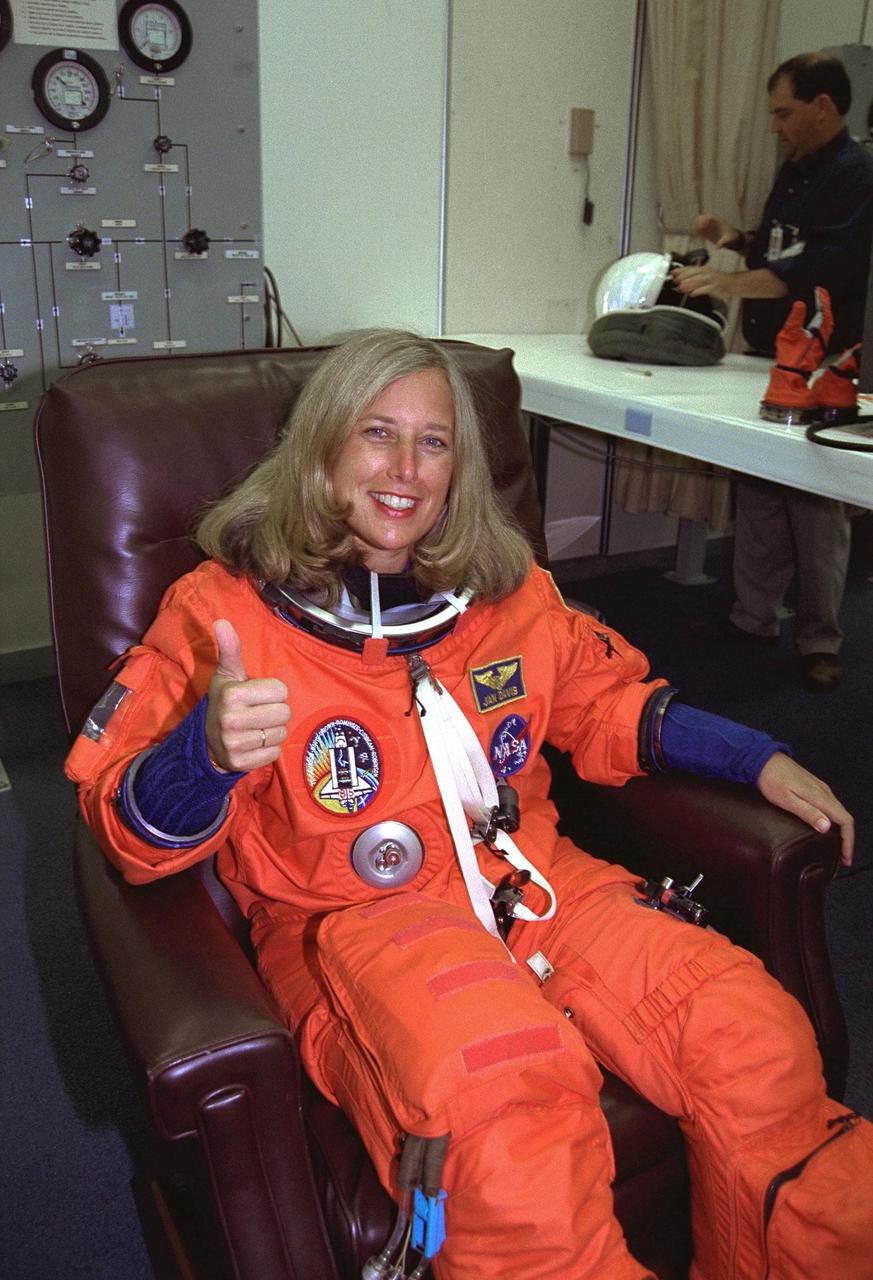
STS-85 Payload Commander N. Jan Davis gives a thumbs up as she is assisted with her ascent/reentry flight suit in the Operations and Checkout (O&C) Building. She has logged nearly 400 hours in space on the STS-47 and STS-60 missions and holds a doctorate in mechanical engineering. Davis will have overall responsibility for the experiments conducted on STS-85. She will also deploy and retrieve the Cryogenic Infrared Spectrometers and Telescopes for the AtmosphereShuttle Pallet Satellite-2 (CRISTA-SPAS-2) free-flyer and operate the prototype Japanese robotic arm. The primary payload aboard the Space Shuttle orbiter Discovery is the CRISTA-SPAS-2. Other payloads on the 11-day mission include the Manipulator Flight Demonstration (MFD), and Technology Applications and Science-1 (TAS-1) and International Extreme Ultraviolet Hitchhiker-2 (IEH-2) experiments
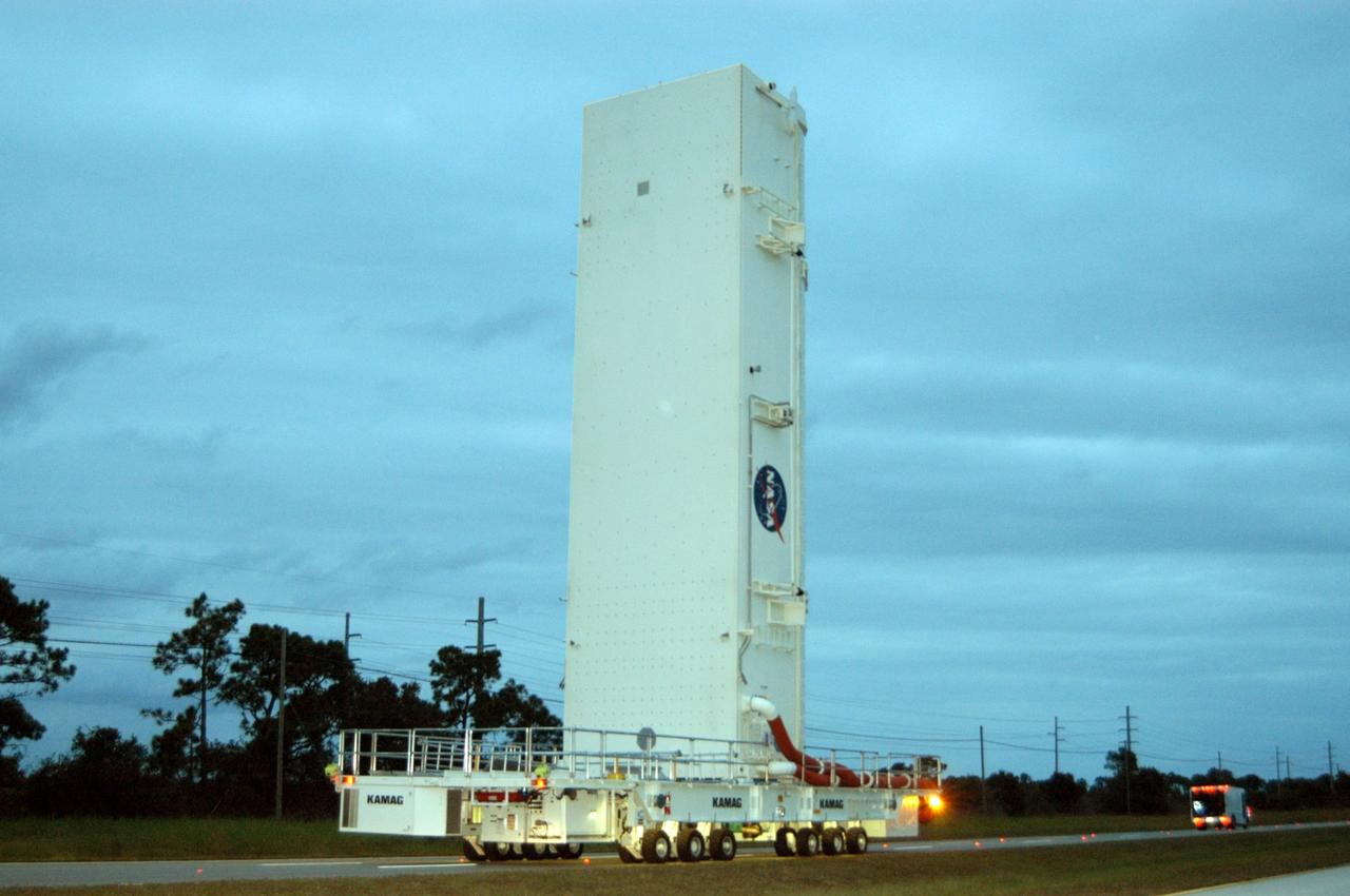
KENNEDY SPACE CENTER, FLA. -- Under a darkening, cloud-covered sky, the payload canister transporter carries its cargo very slowly along the road to Launch Pad 39B for mission STS-116. Inside the canister are the SPACEHAB module and the port 5 truss segment, which will be moved into the payload changeout room at the pad and transferred into Space Shuttle Discovery's payload bay once the vehicle has rolled out to the pad. The payload canister is 65 feet long, 18 feet wide and 18 feet, 7 inches high. It has the capability to carry vertically or horizontally processed payloads up to 15 feet in diameter and 60 feet long, matching the capacity of the orbiter payload bay. It can carry payloads weighing up to 65,000 pounds. Clamshell-shaped doors at the top of the canister operate like the orbiter payload bay doors, with the same allowable clearances. Photo credit: NASA/George Shelton
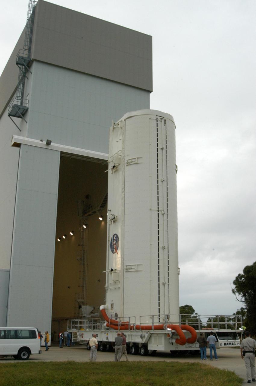
KENNEDY SPACE CENTER, FLA. -- Installed on a transporter, the payload canister moves out of the Vertical Processing Facility. Inside the canister are the SPACEHAB module and the port 5 truss segment for mission STS-116. They will be moved into the payload changeout room at the pad and transferred into Space Shuttle Discovery's payload bay once the vehicle has rolled out to the pad. The payload canister is 65 feet long, 18 feet wide and 18 feet, 7 inches high. It has the capability to carry vertically or horizontally processed payloads up to 15 feet in diameter and 60 feet long, matching the capacity of the orbiter payload bay. It can carry payloads weighing up to 65,000 pounds. Clamshell-shaped doors at the top of the canister operate like the orbiter payload bay doors, with the same allowable clearances. Photo credit: NASA/George Shelton
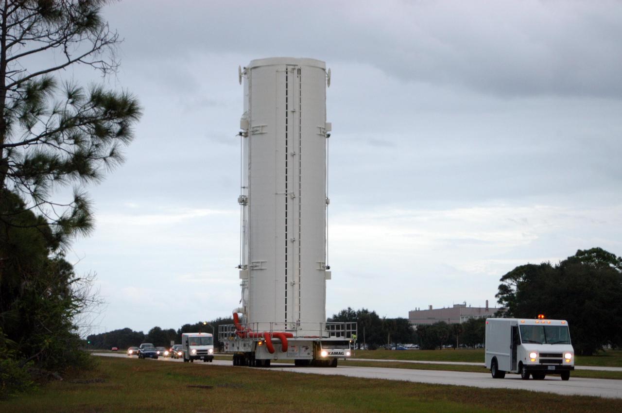
KENNEDY SPACE CENTER, FLA. -- The payload canister transporter carries its cargo very slowly along the road to Launch Pad 39B for mission STS-116. Inside the canister are the SPACEHAB module and the port 5 truss segment, which will be moved into the payload changeout room at the pad and transferred into Space Shuttle Discovery's payload bay once the vehicle has rolled out to the pad. The payload canister is 65 feet long, 18 feet wide and 18 feet, 7 inches high. It has the capability to carry vertically or horizontally processed payloads up to 15 feet in diameter and 60 feet long, matching the capacity of the orbiter payload bay. It can carry payloads weighing up to 65,000 pounds. Clamshell-shaped doors at the top of the canister operate like the orbiter payload bay doors, with the same allowable clearances. Photo credit: NASA/George Shelton
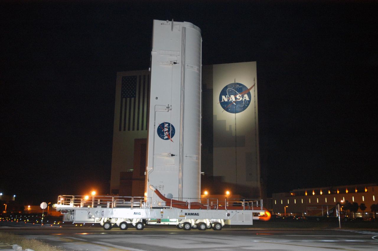
KENNEDY SPACE CENTER, FLA. -- Lamps spotlight the payload canister transporter as it slowly carries its cargo past the Vehicle Assembly Building on the road to Launch Pad 39B for mission STS-116. Inside the canister are the SPACEHAB module and the port 5 truss segment, which will be moved into the payload changeout room at the pad and transferred into Space Shuttle Discovery's payload bay once the vehicle has rolled out to the pad. The payload canister is 65 feet long, 18 feet wide and 18 feet, 7 inches high. It has the capability to carry vertically or horizontally processed payloads up to 15 feet in diameter and 60 feet long, matching the capacity of the orbiter payload bay. It can carry payloads weighing up to 65,000 pounds. Clamshell-shaped doors at the top of the canister operate like the orbiter payload bay doors, with the same allowable clearances. Photo credit: NASA/George Shelton
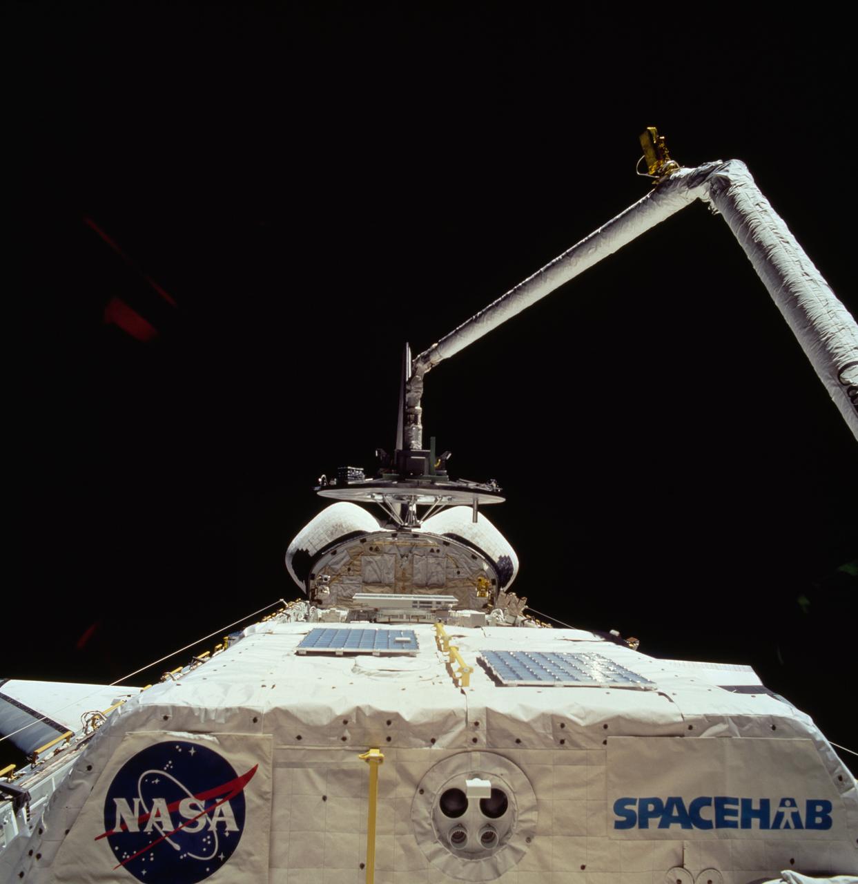
STS060-74-054 (3-11 Feb 1994) --- The Wake Shield Facility (WSF) is held in the grasp of Discovery's Remote Manipulator System (RMS). The 70mm image, backdropped against the blackness of space, also shows the SPACEHAB module in the forward cargo area.