STS062-05-035 (4-18 March 1994) --- This 35mm frame, photographed on the aft flight deck of the earth-orbiting Space Shuttle Columbia, captures crew activity with the Dexterous End Effector (DEE) on the Remote Manipulator System (RMS). Astronauts Pierre J. Thuot and Marsha S. Ivins communicate with ground controllers during operations and observations with DEE. During the 14-day mission, three of the five STS-62 crewmembers took turns operating and observing the RMS in a series of one-hour sessions.
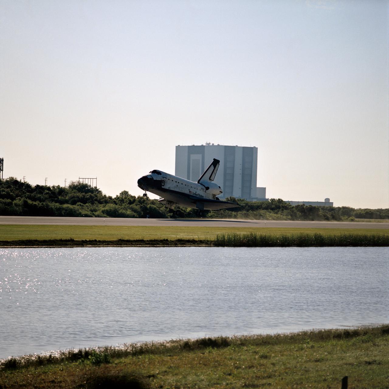
STS062-S-030 (18 March 1994) --- The Space Shuttle Columbia is about to touch down on the Shuttle landing facility following almost 14 days in earth orbit for five NASA astronauts and a variety of experiments. The giant Vehicle Assembly Building (VAB) where Columbia had been mated to its external fuel tank and two solid rockets is in the background. Touchdown occurred at 8:09 a.m. (EST), March 18, 1994. Thirteen days, 23 hours and 16 minutes were logged by the crew members -- astronauts John H. Casper, Andrew M. Allen, Marsha S. Ivins, Pierre J. Thuot and Charles D. (Sam) Gemar.
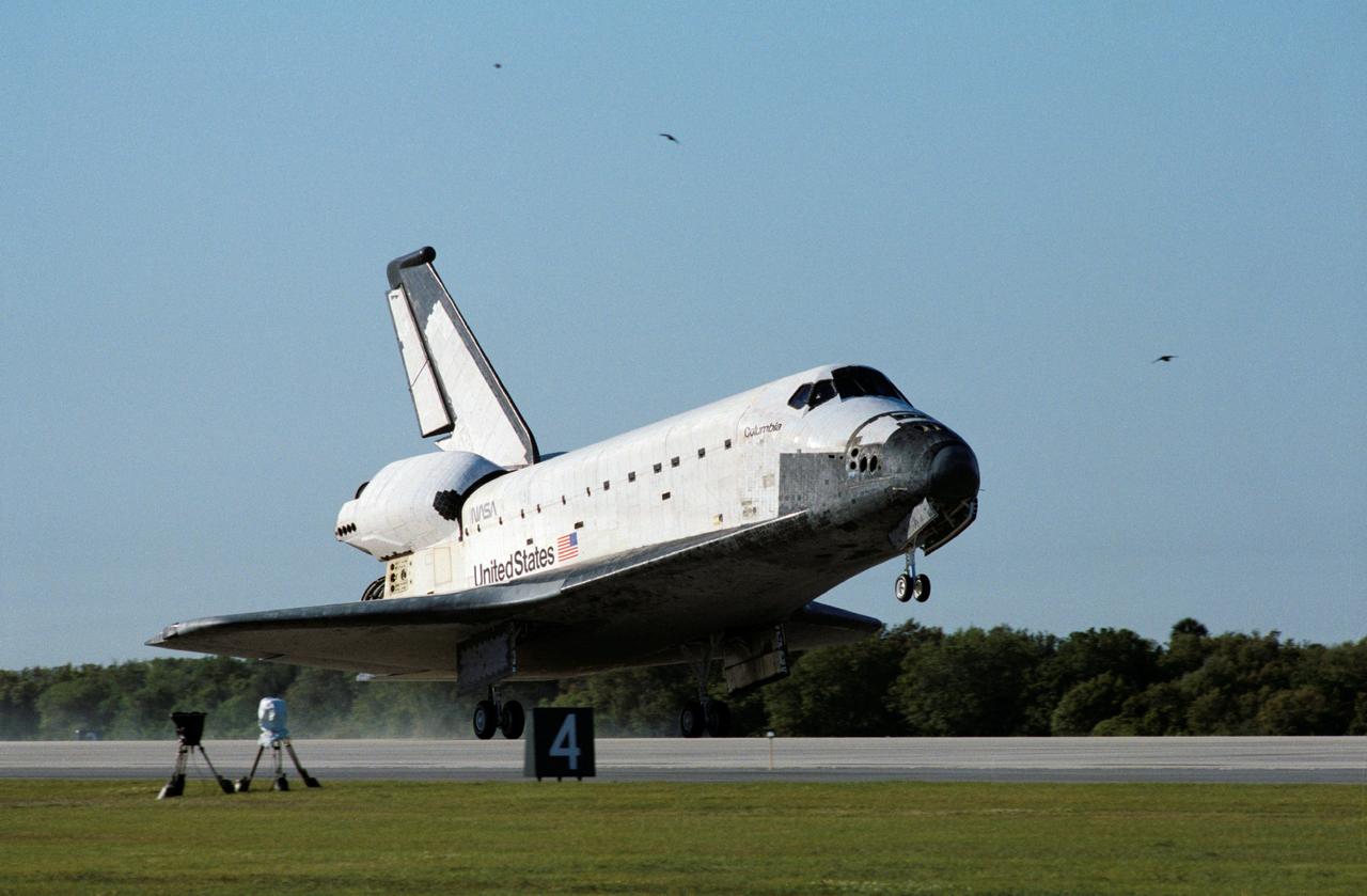
STS062-S-031 (18 March 1994) --- The main landing gear on the Space Shuttle Columbia touches down on the Shuttle Landing Facility at Kennedy Space Center (KSC). The scene followed almost 14-days in Earth-orbit for five NASA astronauts and a variety of experiments. Touch down occurred at 8:09 a.m. (EST), March 18, 1994. Thirteen days, 23 hours and 16 minutes were logged by the crew members -- astronauts John H. Casper, Andrew M. Allen, Marsha S. Ivins, Pierre J. Thuot and Charles D. (Sam) Gemar.
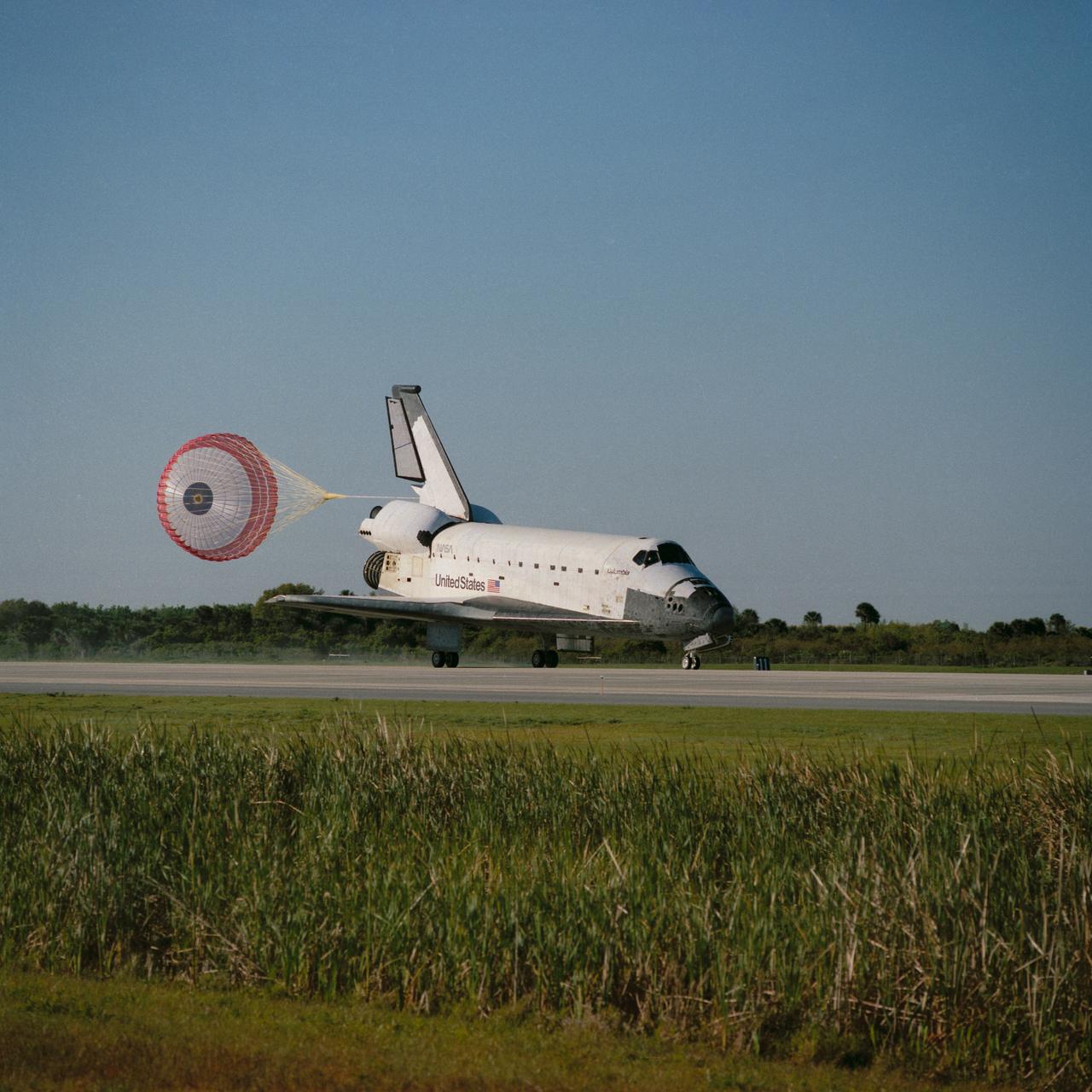
STS062-S-029 (18 March 1994) --- The drag chute on the Space Shuttle Columbia is deployed as the spacecraft rolls down the Shuttle landing facility at Kennedy Space Center (KSC). The scene followed almost 14 days in earth orbit for five NASA astronauts and a variety of experiments. Touchdown occurred at 8:09 a.m. (EST), March 18, 1994. Thirteen days, 23 hours and 16 minutes were logged by the crew members -- astronauts John H. Casper, Andrew M. Allen, Marsha S. Ivins, Pierre J. Thuot and Charles D. (Sam) Gemar.
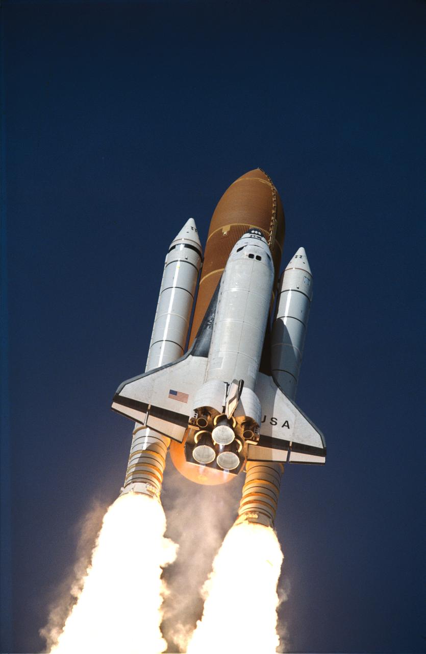
STS062-S-055 (4 March 1994) --- A low-angle view captures early stages of the sixteenth launch of Space Shuttle Columbia. Launch occurred at 8:53 a.m. (EST), March 4, 1994. Onboard were astronauts John H. Casper, Andrew M. Allen, Marsha S. Ivins, Charles D. (Sam) Gemar and Pierre J. Thuot.
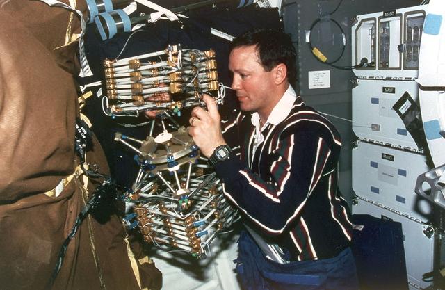
Astronaut Pierre J. Thuot, mission specialist, works with the Mid-deck 0-gravity Dynamics Experiment (MODE) aboard the Earth-orbiting Space Shuttle Columbia (STS-62). MODE studies the dynamics of liquids and skewed space structures in the microgravity environment.
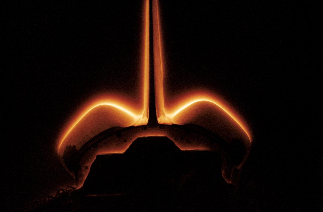
STS062-42-026 (4-18 March 1994) --- This 35mm frame, photographed as the Space Shuttle Columbia was orbiting Earth during a "night" pass, documents the glow phenomenon surrounding the vertical stabilizer and the Orbital Maneuvering System (OMS) pods of the spacecraft.
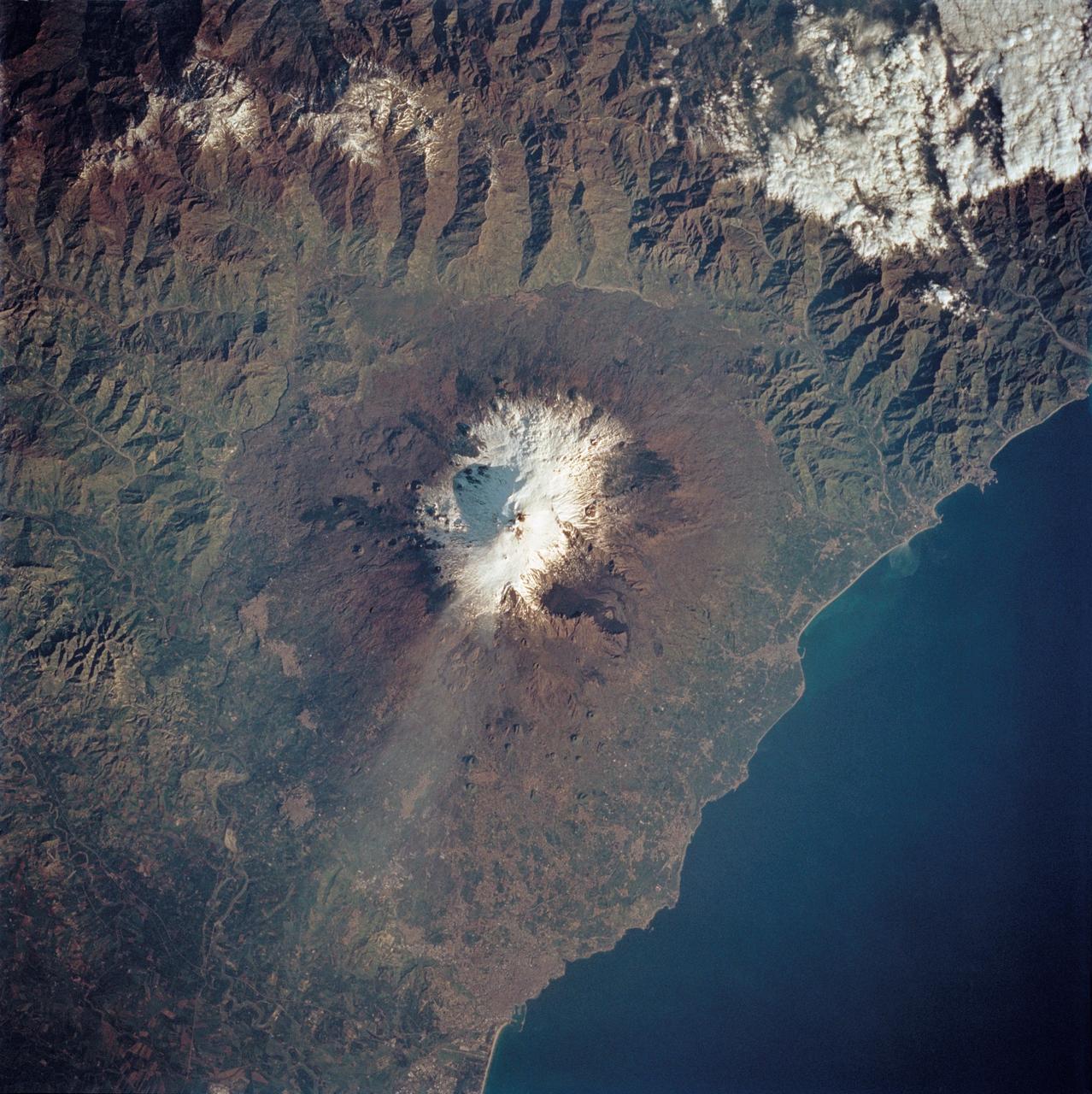
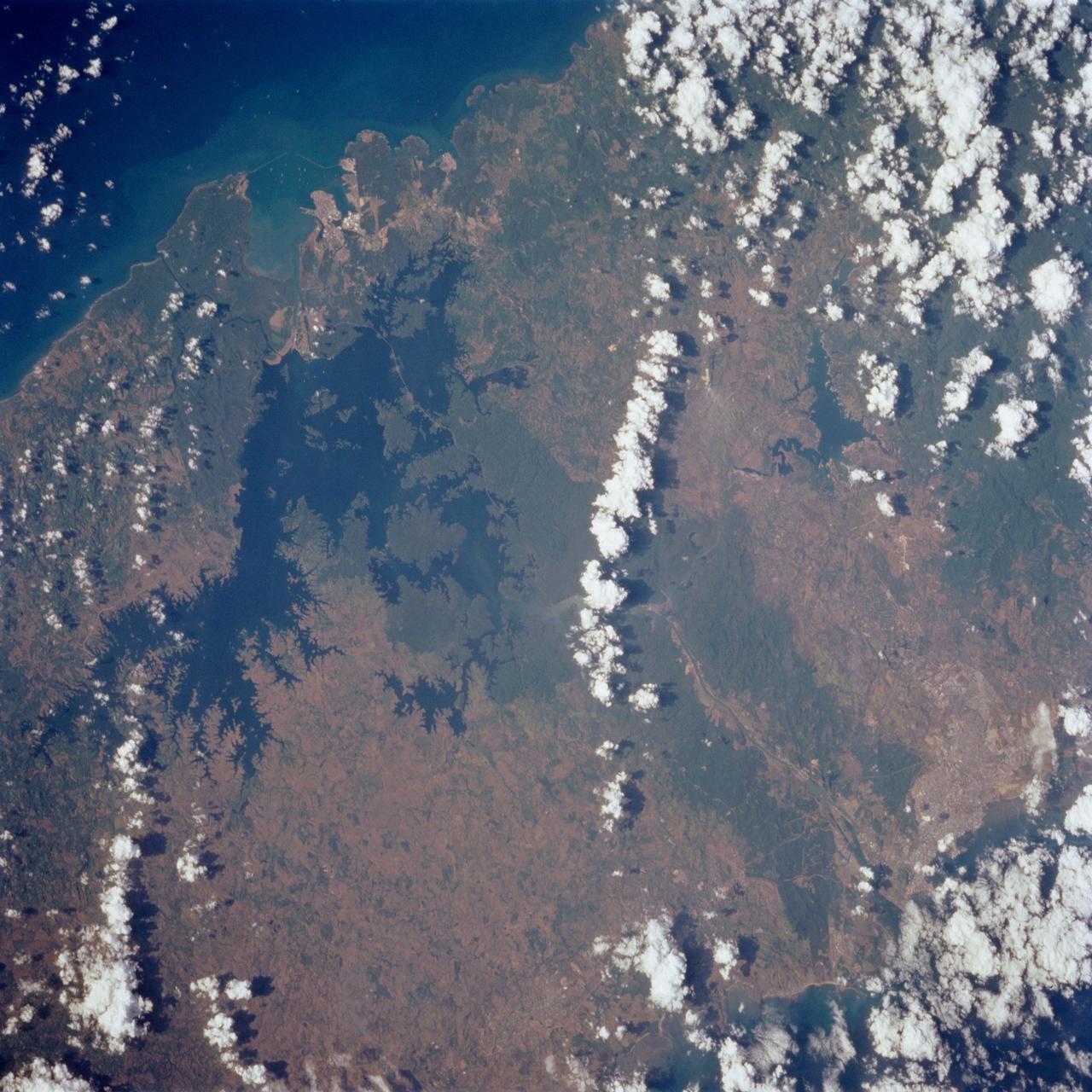
STS062-85-195 (4-18 March 1994) --- A thin plume of steam blows southward from the summit of Mt. Etna, the active volcano on the island of Sicily. The summit is capped with snow but the dark lava flow along the eastern flank (the 1991-93 flow) is clearly visible. The coastal city south of Etna is Catania.
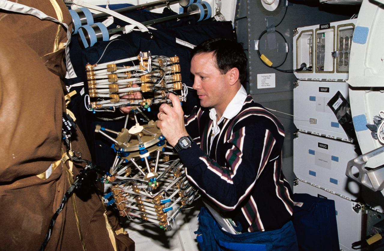
STS062-52-025 (4-18 March 1994) --- Astronaut Pierre J. Thuot, mission specialist, works with the Middeck 0-Gravity Dynamics Experiment (MODE) aboard the earth-orbiting Space Shuttle Columbia. The reusable test facility is designed to study the nonlinear, gravity-dependent behavior of two types of space hardware -- contained fluids and (as depicted here) large space structures -- planned for future spacecraft.
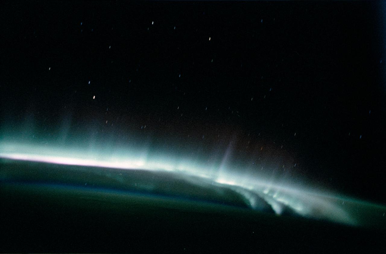
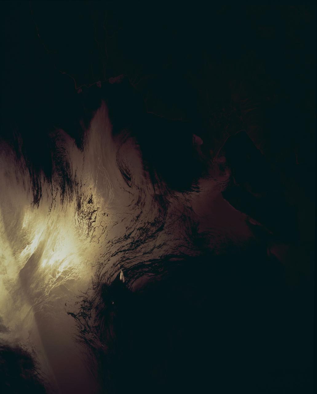
STS062-58-025 (4-18 March) --- This photo shows the aurora australis or souther lights. The multi-hued shafts of light, extending upward to 200 miles above the earth's surface, are caused by beams of energetic electrons colliding with the oxygen and nitrogen in the earth's upper atmosphere. The strong red glow occurs at the highest altitude where the air is least dense and composed mostly of oxygen. At lower altitudes, the greater density favors the green color, also produced by atomic oxygen. Sometimes at the bottom (the lowest altitude of the aurora) a pink border is produced by nitrogen. The aurora usually can be seen only in Arctic regions. However, because of the tilt of the magnetic axis of the space shuttle mission orbits. One of these regions is over eastern North American, and the second one is south of Australia. Since most shuttle launches occur in daytime, the North American region is in daylight, and the only auroras that can be seen are usually in the Southern Hemisphere.
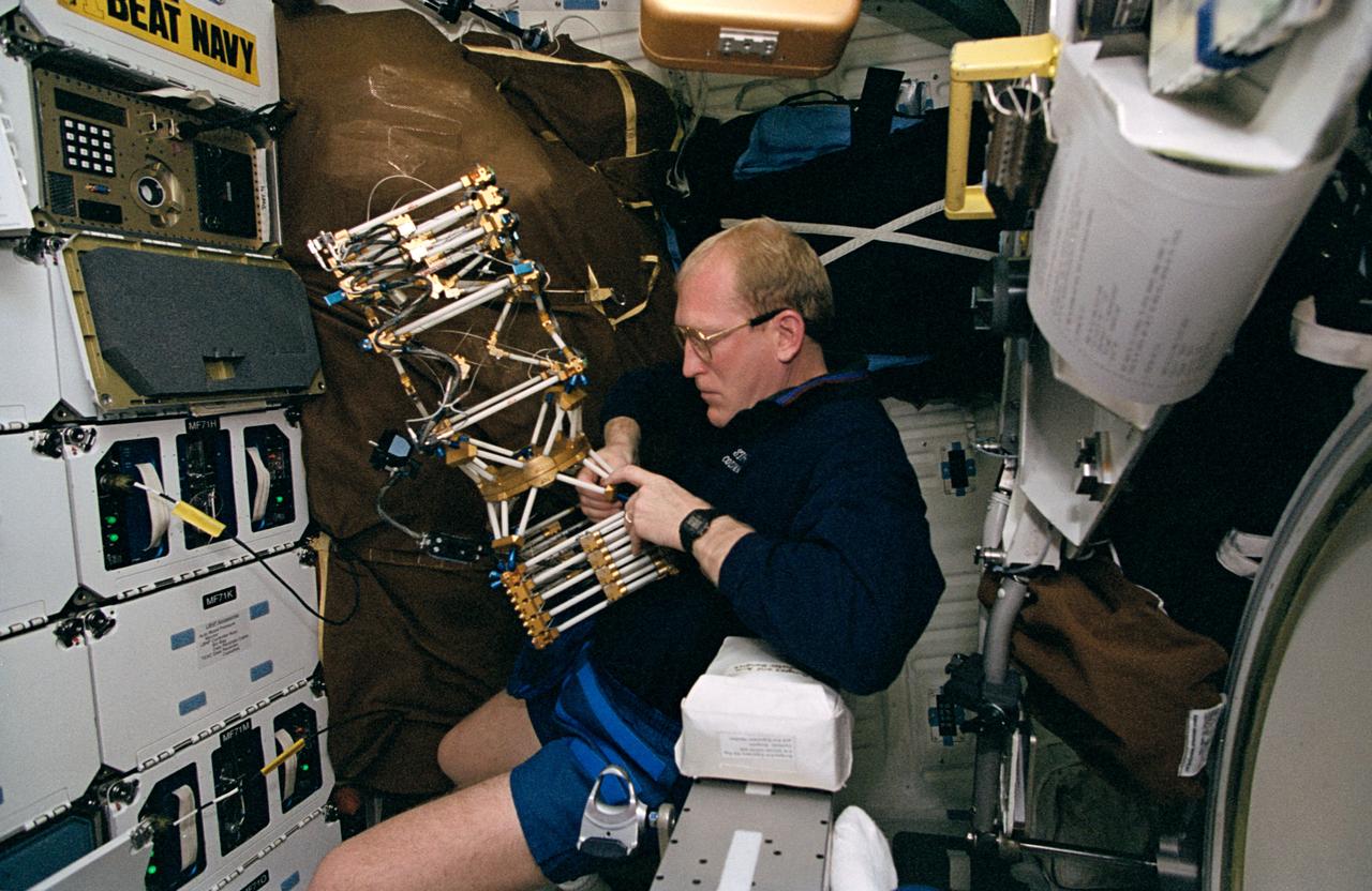
STS062-23-017 (4-18 March 1994) --- Astronaut Charles D. (Sam) Gemar, mission specialist, works with Middeck 0-Gravity Dynamics Experiment (MODE) aboard the earth-orbiting Space Shuttle Columbia. The reusable test facility is designed to study the nonlinear, gravity-dependent behavior of two types of space hardware -- contained fluids and (as depicted here) large space structures -- planned for future spacecraft.
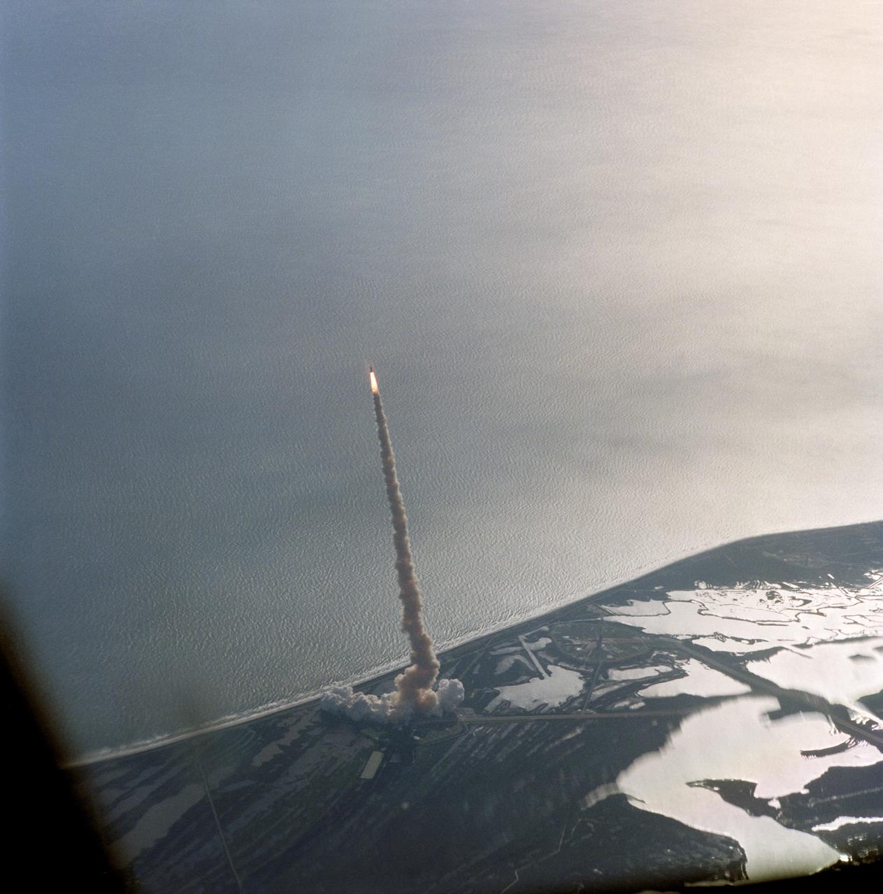
STS062-S-061 (4 March 1994) --- An aerial view of early stages of the sixteenth launch of Space Shuttle Columbia was provided by a 70mm camera aboard the Shuttle Training Aircraft (STA). Launch occurred at 8:53 a.m. (EST), March 4, 1994. Onboard were astronauts John H. Casper, Andrew M. Allen, Marsha S. Ivins, Charles D. (Sam) Gemar and Pierre J. Thuot.
STS062-85-095 (4-18 March 1994) --- Gatun Lake and the forested Panama Canal Zone can be seen in this north northwest-looking low oblique photograph obtained in March 1994. The shipping chanel of the canal is 82.4 kilometers (51.2 miles) long, though the canal zone is only 65 kilometers (40 miles) long. The width of the canal zones extends generally 8 kilometers (5 miles) on either side of the shipping channel, except near Madden Lake. The canal connects the Atlantic Ocean (coastal city of Colon) with the Pacific Ocean near Panama City in a line that takes a northwest to southeast course because of the configuration of the isthmus. The canal zigzags across the isthmus to take advantage of the geographic features of the area such as the Chagres River. The controlled water supply for the canal is provided by the three artificial lakes: Gatun near the Atlantic terminus, Miraflores near the Pacific terminus and Madden about halfway across the isthmus. Gatun is the largest of the three lakes covering an area of 429 square kilometers (165 square miles). In the midst of this lake is Barro Colorado Island, a world-famous wild game perserve. Madden Lake was built as a large supplemental reservoir to keep water levels up in the canal during the dry season. All three lakes are vital sources of water for maintaining the ship channel over the continental divide (Gaillard Cut) and for regulating the flow of water that enables hugh vessels to be lifted and lowered in massive locks.
STS062-15-013 (4-18 March 1994) --- Astronaut John H. Casper, mission commander, participates in an experiment that measures the effects of space flight on pilot proficiency. Astronauts Casper and Andrew M. Allen, pilot, continued the testing of the Portable Inflight Landing Operations Trainer (PILOT), which first flew onboard Columbia in October of 1993.
STS062-106-042 (4-18 March 1994) --- This view of southern Australia about 100 miles northwest of Melbourne shows areas of protected reserves of natural forests in the midst of agricultural crop lands. The green patch seen here has been recently burned as indicated by the irregular large scar. The impact of winds on the scar is clearly visible. This nature preserve is reported to be the home to a large number of animals including the koala bears. Similar views were shot by the STS-60 crewmembers last month. These photographs will assist earth scientists in mapping the impact of forest fires and in moniotring the recovery of burned areas.
STS062-04-005 (4-18 March 1994) --- Astronaut Marsha S. Ivins has her hands full with a thermal imaging project on the flight deck of the Space Shuttle Columbia as astronaut Pierre J. Thuot stands by to help. The two mission specialists were joined by three other veteran NASA astronauts for almost 14 full days in Earth-orbit.
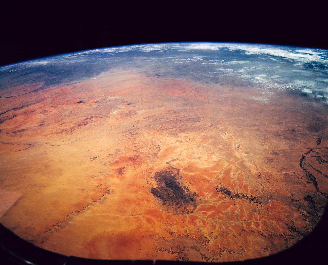
STS062-151-182Z (4-18 March 1994) --- This east-looking view shows most of the east-west extent of the country of Sudan. The foreground shows a vegetation-less and almost uninhabited region of northwest Sudan. The rich earth colors are ancient soils (browner and redder tones), a concentrated mass of what may be volcanic cinder cones (dark brown dots - center) and dune and younger river sediments (yellows). The photo would have been difficult to locate had it not been for two recognizable features in the background: a visually well-known inselberg ("island mountain" -- top center) on a large west-bank tributary of the White Nile; and the confluence of the Blue and White Nile's, with the great cotton developments of the Gezira Scheme between them (top left). The Red Sea coast is almost obscured by a dust cloud but can be discerned running across the top of the picture. The clouds at top may be developing over the coastal ranges of Saudi Arabia beyond the Red Sea.
STS062-86-196 (4-18 March 1994) --- This photo depicts many of the types of ocean features seen when illuminated by sunglint. These features include a shear line, bilge dump, currents and ship wakes. Winds, currents and oils effect the smoothness of the surface of the water. The oils smooth the water which reflect the sun more than the rougher surround water. This is seen in the bright curved line which is a bilge dump of oily water from a ship. The oils then start to take the form of the currents and in this case are also being blown by the surface winds. The shear line is approximately 240 miles west of Bombay, India. This shear line appears to be a result of two water masses, moving at slightly different speeds, having converged. Ship wakes, such as those in the photo, which cross a shear line, often give us an indication of the relative strenght of a a shear.
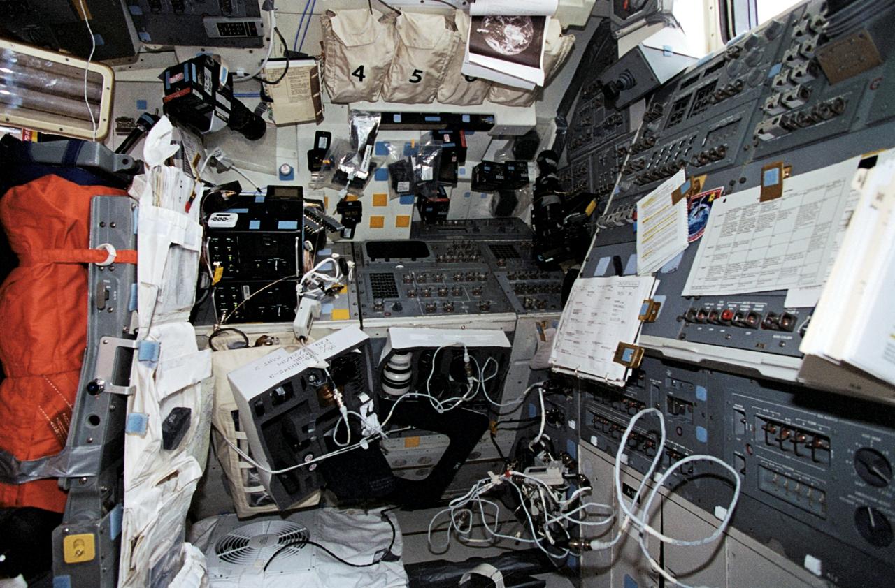
STS062-17-034 (4-18 March 1994) --- This scene, resembling a photographer's studio/laboratory, actually shows the aft flight deck of the Earth-orbiting Space Shuttle Columbia. A variety of cameras, lenses, visual aids and other gear are seen stowed around the flight deck. The five astronaut crew members devoted a large portion of their on-duty time at this workstation using some of this photographic equipment to record Earth imagery.
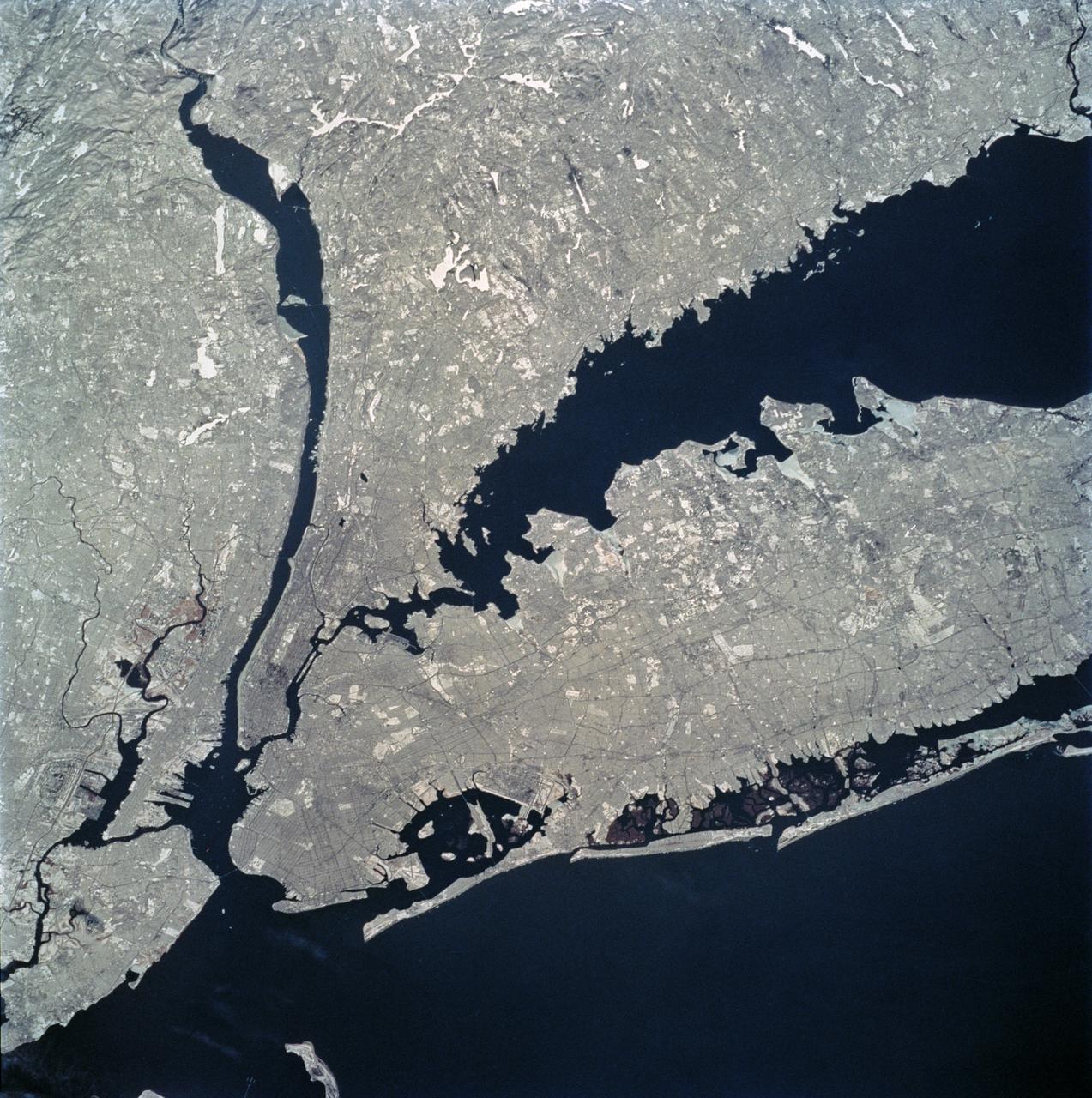
STS062-81-010 (4-18 March 1994) --- The recent heavy snowfalls help to accentuate the major transportation networks, (railroads, highways and airports), throughout the New York City metropolitan area. This particular scene also highlights the land-water boundaries and the lighter open spaces, such as parks, cemeteries and recreational areas. The snows have produced a white blanket effect on these areas. Even some of the snow-covered lakes can be discerned. The boroughs of Staten Island, Brooklyn, Queens, The Bronx and Manhattan are also recognizable on the photograph.
STS062-85-147 (4-18 March 1994) --- Hartsfield Atlanta International Airport is visible to the south of Atlanta, situated near the center of the photograph. Dobbins Air Force Base and the city of Marietta can also be seen to the north of Atlanta in this south-looking low-oblique view. The complex system of transportation routes and interstate highways surrounding and traversing Atlanta can also be seen in the photograph. The white dot near the center of the photograph is the Georgia Dome, a major sports and entertainment complex in downtown Atlanta. Atlanta is the cultural, industrial, transportation, financial and commercial center of the South. It has one of the busies air traffic hubs in the United States. A major aircraft assembly plant is located north of Atlanta in Marietta. The Stone Mountain Memorial, with its enormous relief carvings of Confederate figures, is located east of Atlanta and is visible on the photograph.
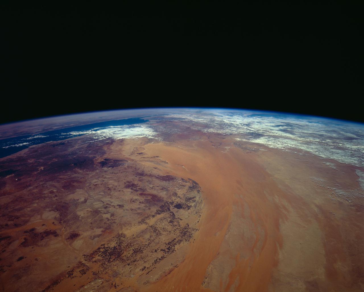
STS062-151-220 (4-18 March 1994) --- Great numbers of circular, center-pivot irrigation plots appear in this west-looking view of the northern Saudi Arabia (center to lower left). So many plots now exist that the face of Saudi Arabia as seen from low earth orbit has changed. Until a few years ago, there were only a few scattered center-pivots. Now the entire swath of country between the shifting sands of the Ad Dahna Sand Sea (light colors center and right) and the almost soilless Nejd Plateau (left) has been darkened by thousands of these agricultural fields. The Nejd Plateau is a mass of dark rocks, some volcanic, in NW Saudi Arabia. Water from this higher country flows east towards the agricultural region where it is pumped up from underground aquifers. The weep of the Ad Dahna Sand Sea is one of the major features of Saudi Arabia (center and right) as seen from the orbiter. The dunes follow the trend of regional winds (northwesterly in the center of the view) which circulate around the Nejd plateau. The north end of the Red Sea can be seen top left with the Sinai Peninsula and Mediterranean are just visible center top. Iraq is under cloud top right.
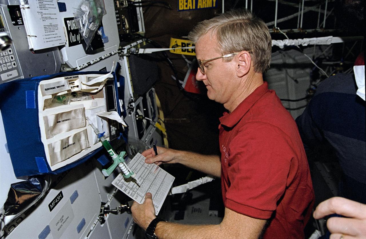
STS062-10-010 (4-18 March 1994) --- Astronaut John H. Casper, mission commander, takes stock of paraphenalia used to support medical testing onboard Columbia's middeck. Casper was poind by four other veteran astronauts for 14 days of variegated research in earth orbit.
STS062-153-226 (4-18 March 1994) --- Though it did not reproduce well, this photo gives scientific information to aid in studying all types of earth's processes. It documents ocean features in the sunglint in the Gulf of California, off the Isla Cerralvo, souther Baja, California. Biological oils collect on the surface and shows current patterns, eddies and ship wakes. The small bright spot on the edge of the eddy is a ship dumping oily water from its bilges. The line in the brighter area is a light wind gust roughening the surface.
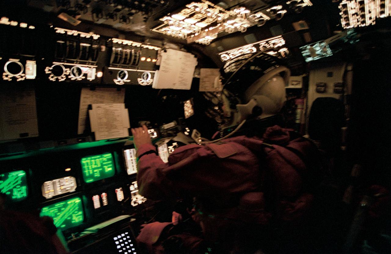
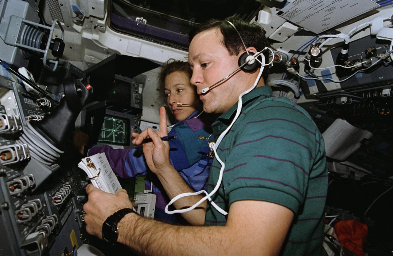
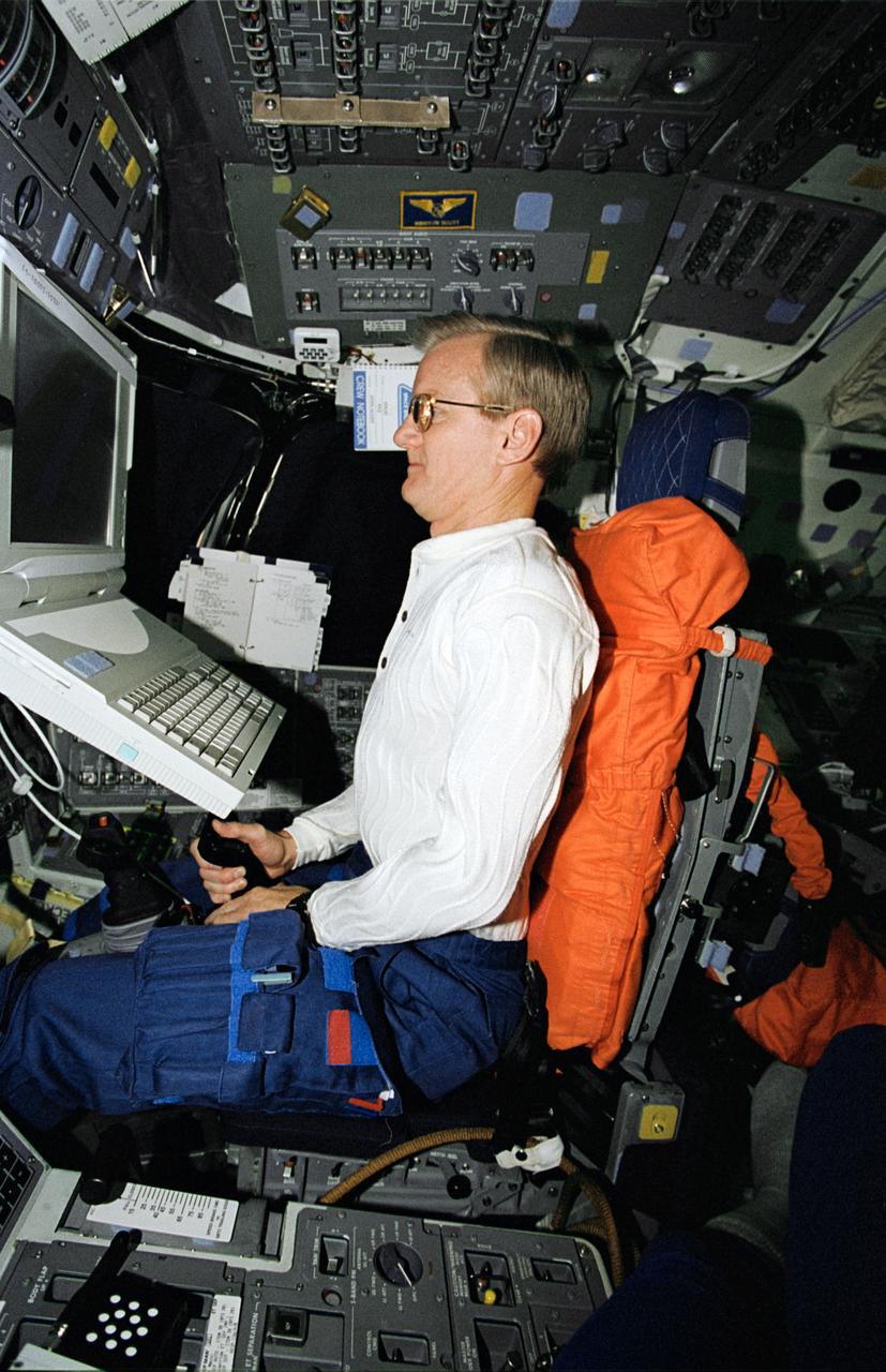
STS062-41-025 (18 March 1994) --- Astronaut Andrew M. Allen monitors Columbia's systems from the pilot's station during the entry phase of the STS-62 mission. The fast-speed 35mm film highlights the many controls and displays and the cathode ray tubes on the forward flight deck.
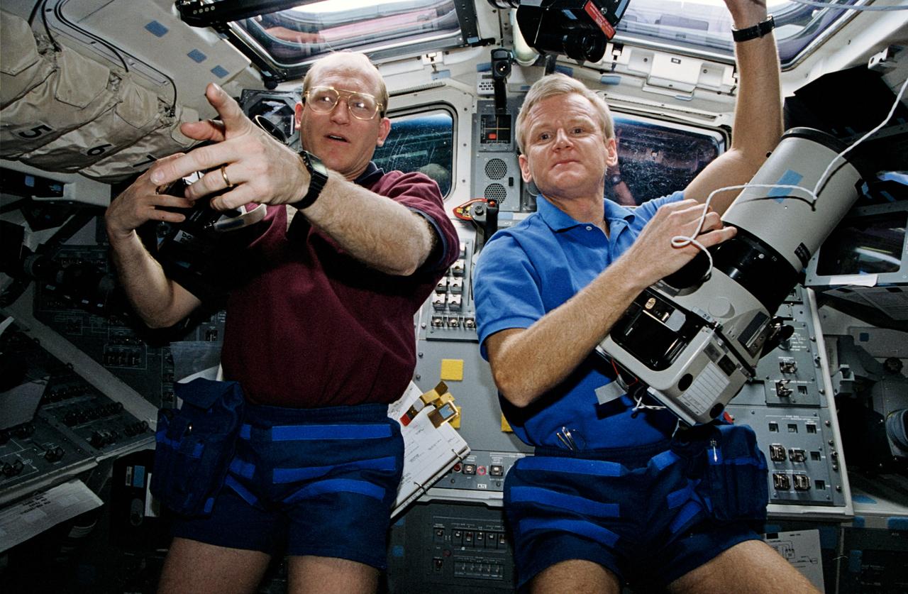
STS062-06-030 (4-18 March 1994) --- With cameras in hand two of the STS-62 astronauts prepare to take pictures of their home planet. John H. Casper (right), mission commander, handles a large format, Linhof camera, while Charles D. (Sam) Gemar, mission specialist, has just added a roll of film to a 70mm handheld Hasselblad camera. Earth observations and documentation occupied muc of the on-duty time of all five of the STS-62 crewmembers during their 14-day mission in earth orbit.
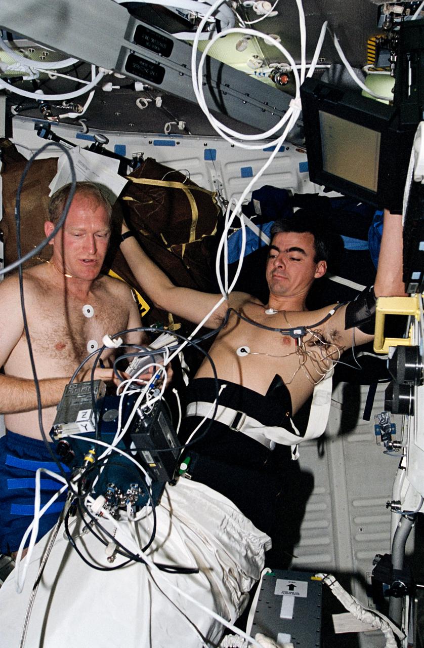
STS062-07-010 (4-18 March 1994) --- Astronaut Andrew M. Allen, pilot, participates in biomedical testing as he does a "soak" in the Lower Body Negative Pressure (LBNP) apparatus on the Columbia's middeck. Astronaut Charles D. (Sam) Gemar, mission specialist, monitors readouts from the test.
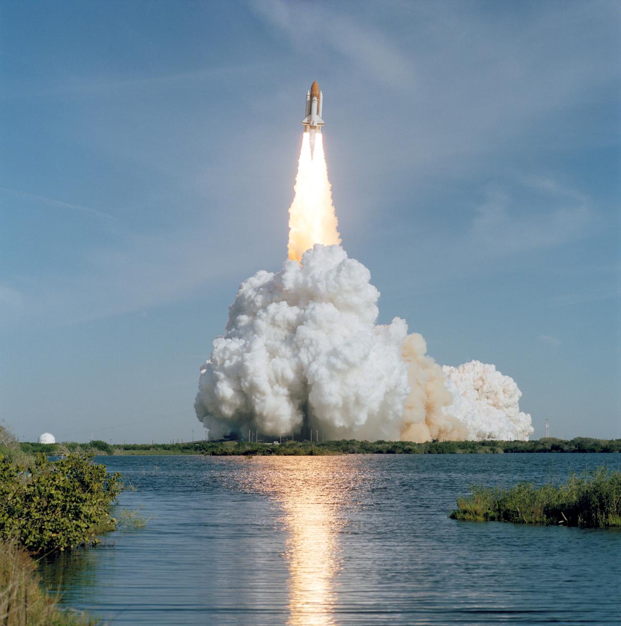
STS062-S-053 (4 March 1994) --- Carrying a crew of five veteran NASA astronauts and the United States Microgravity Payload (USMP), the Space Shuttle Columbia heads toward its sixteenth mission in Earth-orbit. Launch occurred at 8:53 a.m. (EST), March 4, 1994. Onboard were astronauts John H. Casper, Andrew M. Allen, Marsha S. Ivins, Charles D. (Sam) Gemar and Pierre J. Thuot.
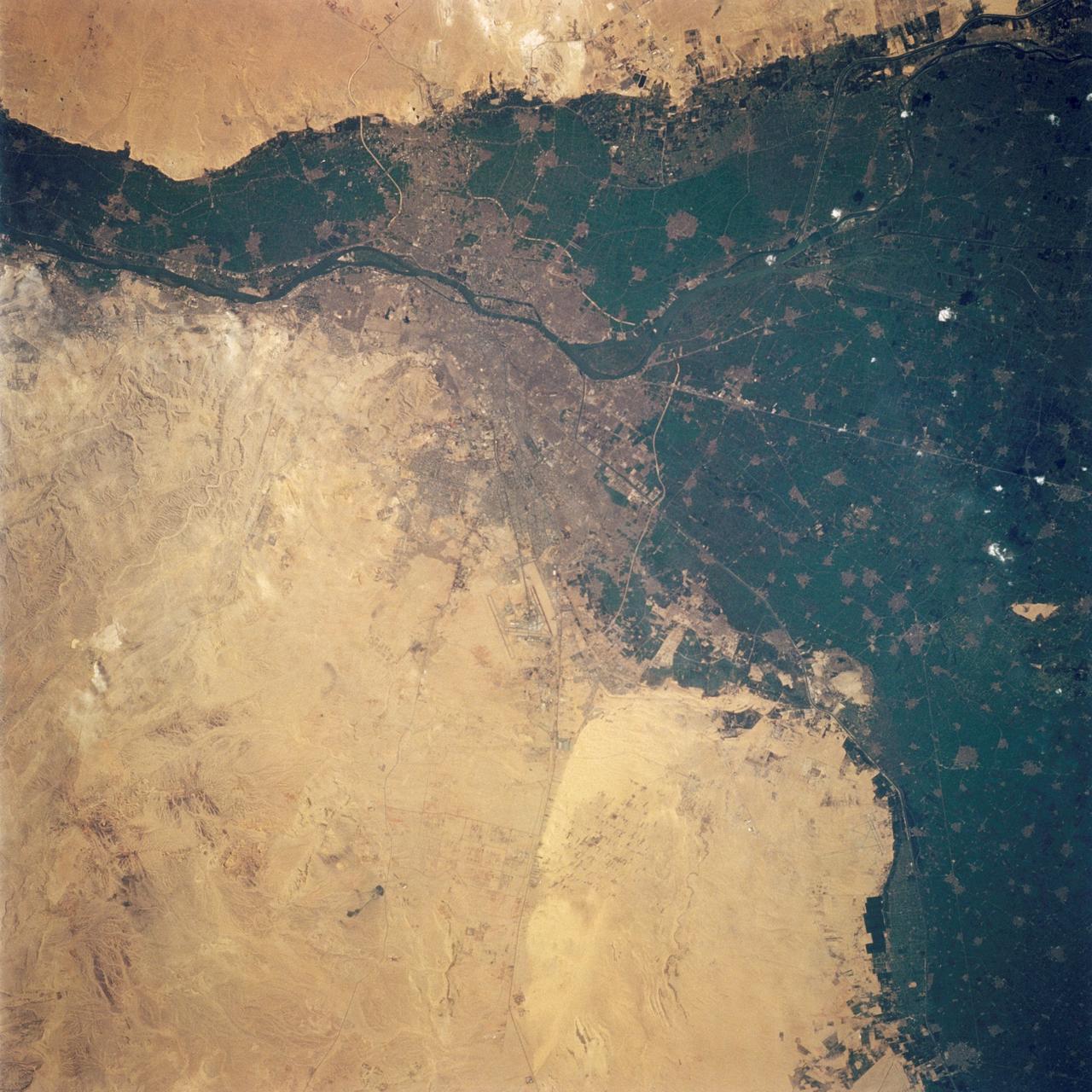
STS062-108-058 (4-18 March 1994) --- Cairo lies at the apex of the great delta of the Nile: the delta is marked by the strong greens of cultivated lands, Cairo by the gray sprawl along the river and the eastern delta apex as it develops in the direction of the airports and Suez. The city of El Giza lies on the west side of the Nile with the Giza pyramids in the desert just beyond the cultivated lands. Several major canals lead water to parts of the delta more distant from the Nile; generally these can be recognized as straighter, more engineered waterways. Towards the top left, the bifurcation of the Rosetta and Damietta branches of the Nile can be seen. These are the two major present-day veins of the Nile as it approaches the Mediterranean.
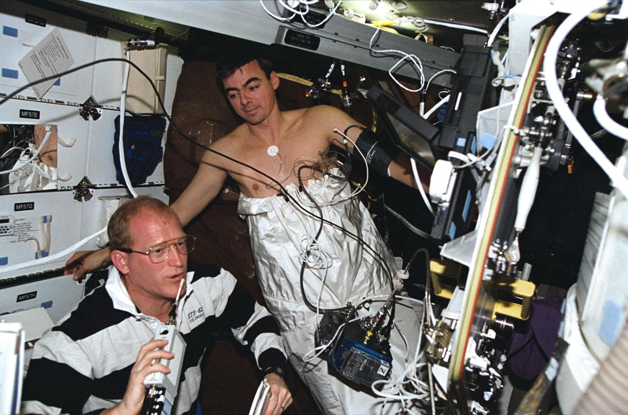
STS062-01-032 (4-14 March 1994) --- Astronaut Charles D. (Sam) Gemar, mission specialist, talks to ground controllers while assisting astronaut Andrew M. Allen with a "soak" in the Lower Body Negative Pressure (LBNP) apparatus on Columbia's middeck. The pair was joined by three other veteran NASA astronauts for 14-days of scientific research aboard the Space Shuttle Columbia in earth orbit.
STS062-85-021 (4-18 March 1994) --- The Mississippi River is the largest river system in North America. Its delta is a typical example of the bird's foot class of river deltas. It drains nearly 3 1/2 million square kilometers of real estate and is estimated to carry 2.4 billion kilograms (more than 500 million tons) of sand, silt, and clay to the Gulf of Mexico annually. Most of this sediment is deposited as a delta at the mouth of the river where the velocity of the river water is slowed and its ability to transport sediment is accordingly diminished. Continued deposition at such a site progrades the delta or extends it seaward into the Gulf as much as 150 meters each year until such time as a flooding episode finds a shorter more efficient channel to deliver sediment-laden river waters to the Gulf. At that time the old delta is abandoned and the river begins to build a new delta. In time, compaction of the sediment in the old delta causes it to subside forming first marshes, then bays. This and the modifying effects of coastal waves eventually allow the sea to reclaim much of the temporary land area of the delta. This sequence has repeated itself over and over again at the Mississippi Delta. In this photograph, the present day active Balize delta is shown. According to NASA scientists it is the youngest of the recent delta lobes having begun its seaward pro-gradation only some 600 - 800 years ago. The main channel of the river is 2 kilometers wide and 30 - 40 meters deep. Natural levees here are almost 1 kilometer wide and 3 to 4 meters above sea level. Along the active distributaries of the lower delta, natural levees are less than 100 meters wide and generally less than 0.5 meters above sea level. The bird's foot appearance of deltas such as this is characteristic of low coastal energy conditions - that is, low levels of tidal fluctuation and generally low wave energy. The interdistributary bays are extremely shallow, usually less than a few meters, and contain brackish to normal marine waters except during times of flooding, when fresh water fills the bays. Sedimentation within the bays is very slow, occurring only during flood periods. Along the west side of the river, a highway has been built southeastward to Venice.
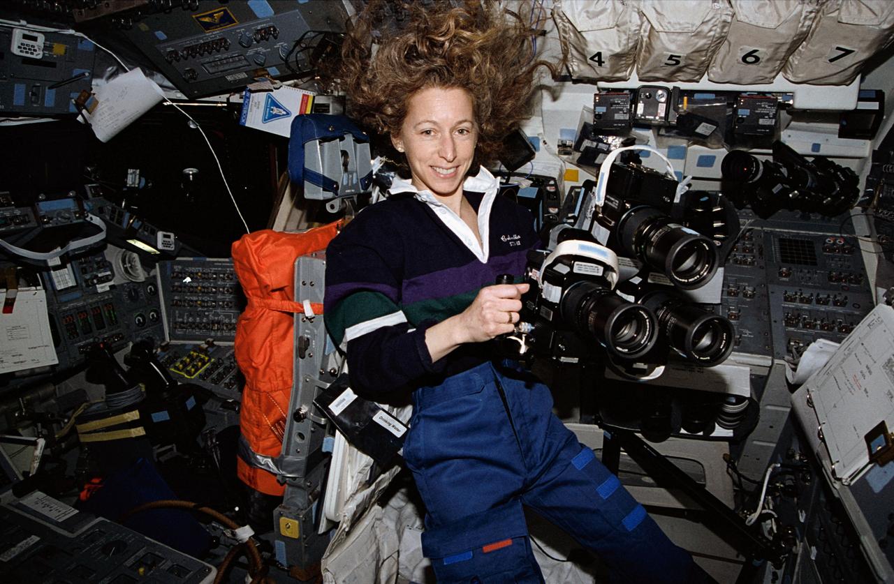
STS062-03-023 (4-14 March 1994) --- Astronaut Marsha S. Ivins, mission specialist, prepares to aim three Hasselblad cameras through the overhead windows of the earth-orbiting Space Shuttle Columbia. The three cameras were allowed to simultaneously record the same imagery on different types of file for purposes of comparison and experimentation.
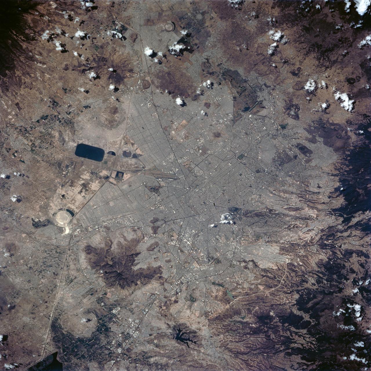
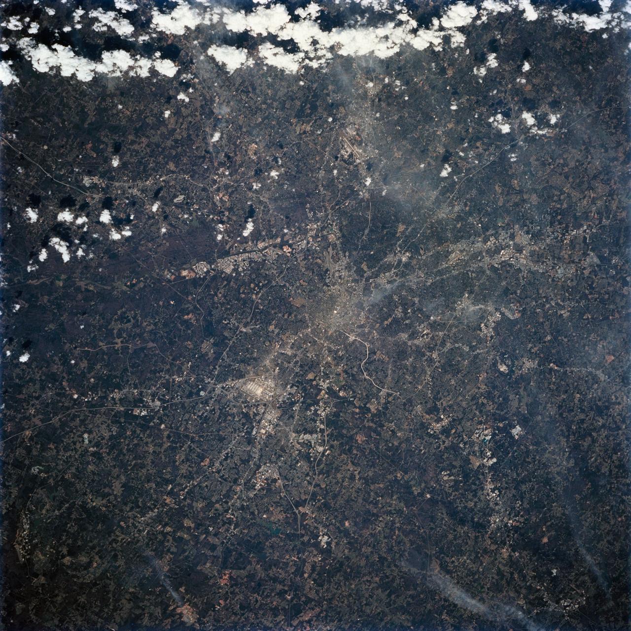
STS062-84-028 (4-18 March 1994) --- According to NASA scientists this image is the clearest photo of Mexico City taken from United States manned spacecraft. North is to the upper right. Mexico City sits in a basin surrounded by large volcanoes. The restricted atmospheric circulation in the basin, coupled with the inevitable air emissions produced by a city of 20 million people has created a critical air pollution problem for the city. In most photographs of the region, Mexico City is obscured by haze. Scientists feel the clear atmosphere in this photograph may be due, in part, to the stringent air emission restrictions now in place. The clarity of the photograph allows many key cultural features to be identified, including all of the major boulevards, the horse track (western part of the city), the university (south of the city), and the museum areas. Large, man-made ponds east of the city also stand out.
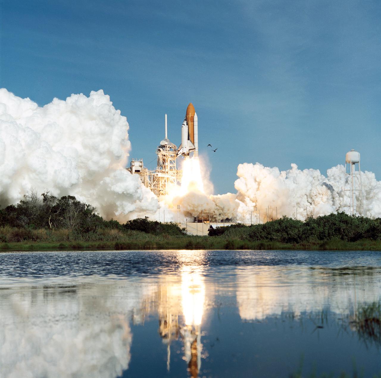
STS062-S-051 (4 March 1994) --- Five veteran astronauts and the United States Microgravity Payload (USMP) are ushered into space via the sixteenth launch of Space Shuttle Columbia. Launch occurred at 8:53 a.m. (EST), March 4, 1994. Onboard were astronauts John H. Casper, Andrew M. Allen, Marsha S. Ivins, Charles D. (Sam) Gemar and Pierre J. Thuot.
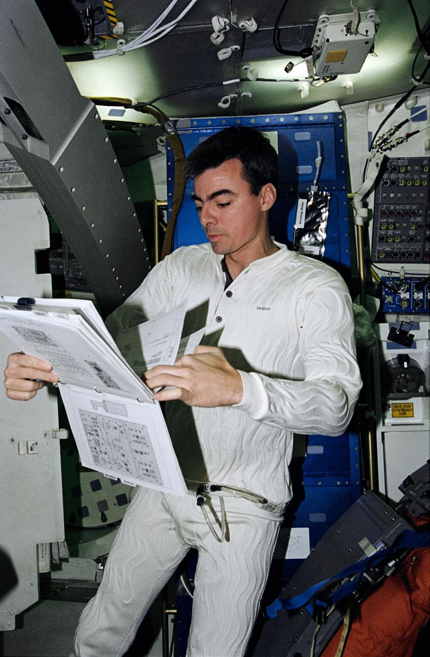
STS062-12-015 (4-18 March 1994) --- On Coumbia's middeck, astronaut Andrew M. Allen, pilot, looks over a procedures book in the midst of a 14-day mission. Allen is attired in a new thermally controlled undergarment. As part of a detailed test objective, both Allen and John H. Casper, mission commander, wore the undergarments during the launch and entry phases of the flight.