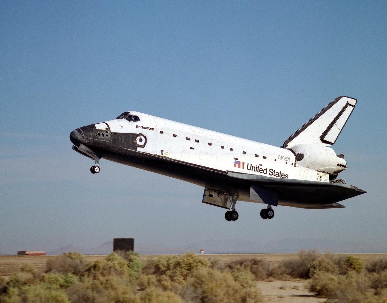
The space shuttle Endeavour glides to a landing on runway 22 at Edwards, California, to complete the highly successful STS-68 mission dedicated to radar imaging of the earth's surface as part of NASA's Mission To Planet Earth program. The landing was at 10:02 a.m. (PDT) 11 October 1994, after waiving off from the Kennedy Space Center, Florida, earlier that morning due to adverse weather at Kennedy. The Endeavour crew was originally scheduled to land at Kennedy the morning of October 10, but mission planners decided early in the flight to extend the mission by one day. Mission commander was Michael A. Baker, making his third flight, and the pilot was Terrence W. Wilcutt, on his first mission.
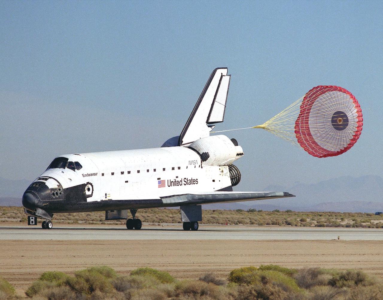
A drag chute slows the shuttle Endeavour after landing on runway 22 at Edwards, California, to complete the highly successful STS-68 mission dedicated to radar imaging of the earth's surface as part of NASA's Mission To Planet Earth program. The landing was at 10:02 a.m. (PDT) 11 October 1994, after waiving off from the Kennedy Space Center, Florida, earlier that morning due to adverse weather at Kennedy. The Endeavour crew was originally scheduled to land at Kennedy the morning of 10 October, but mission planners decided early in the flight to extend the mission by one day. Mission commander was Michael A. Baker and the pilot was Terrence W. Wilcutt. The four mission specialists were Thomas D. Jones, payload; Steven L. Smith; Daniel W. Bursch; and Peter J.K. Wisoff.
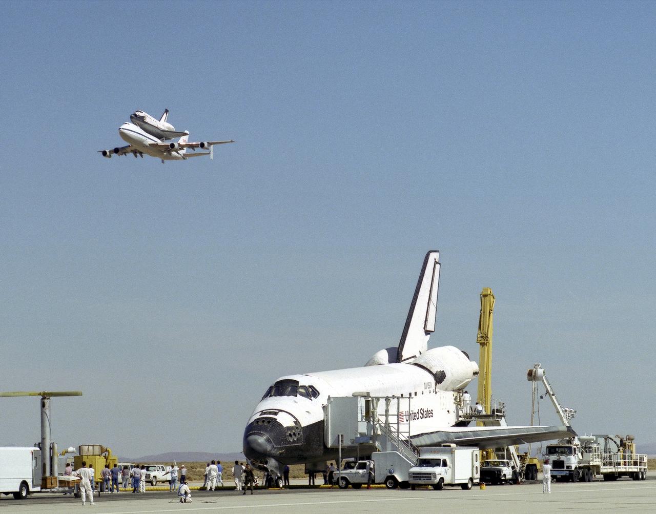
The space shuttle Endeavour receives a high-flying salute from its sister shuttle, Columbia, atop NASA's Shuttle Carrier Aircraft, shortly after Endeavor’s landing 11 October 1994, at Edwards, California, to complete mission STS-68. Columbia was being ferried from the Kennedy Space Center, Florida, to Air Force Plant 42, Palmdale, California, where it will undergo six months of inspections, modifications, and systems upgrades. The STS-68 11-day mission was devoted to radar imaging of Earth's geological features with the Space Radar Laboratory. The orbiter is surrounded by equipment and personnel that make up the ground support convoy that services the space vehicles as soon as they land.
The space shuttle Endeavour receives a high-flying salute from its sister shuttle, Columbia, atop NASA's Shuttle Carrier Aircraft, shortly after Endeavor’s landing 11 October 1994, at Edwards, California, to complete mission STS-68. Columbia was being ferried from the Kennedy Space Center, Florida, to Air Force Plant 42, Palmdale, California, where it will undergo six months of inspections, modifications, and systems upgrades. The STS-68 11-day mission was devoted to radar imaging of Earth's geological features with the Space Radar Laboratory. The orbiter is surrounded by equipment and personnel that make up the ground support convoy that services the space vehicles as soon as they land.
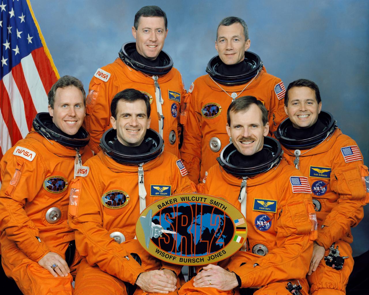
These six NASA astronauts composed the crew of the STS-68 mission that launched aboard the Space Shuttle Endeavour on September 30, 1994. Standing are, left to right, Michael A. Baker, mission commander; and Terrence W. Wilcutt, pilot. On the front row are, left to right, Thomas D. Jones, payload commander; and Peter J. K. (Jeff) Wisoff, Steven L. Smith, and Daniel W. Bursch, all mission specialists. STS-68 marked the second flight of the Space Radar Laboratory, part of NASA’s mission to planet Earth.

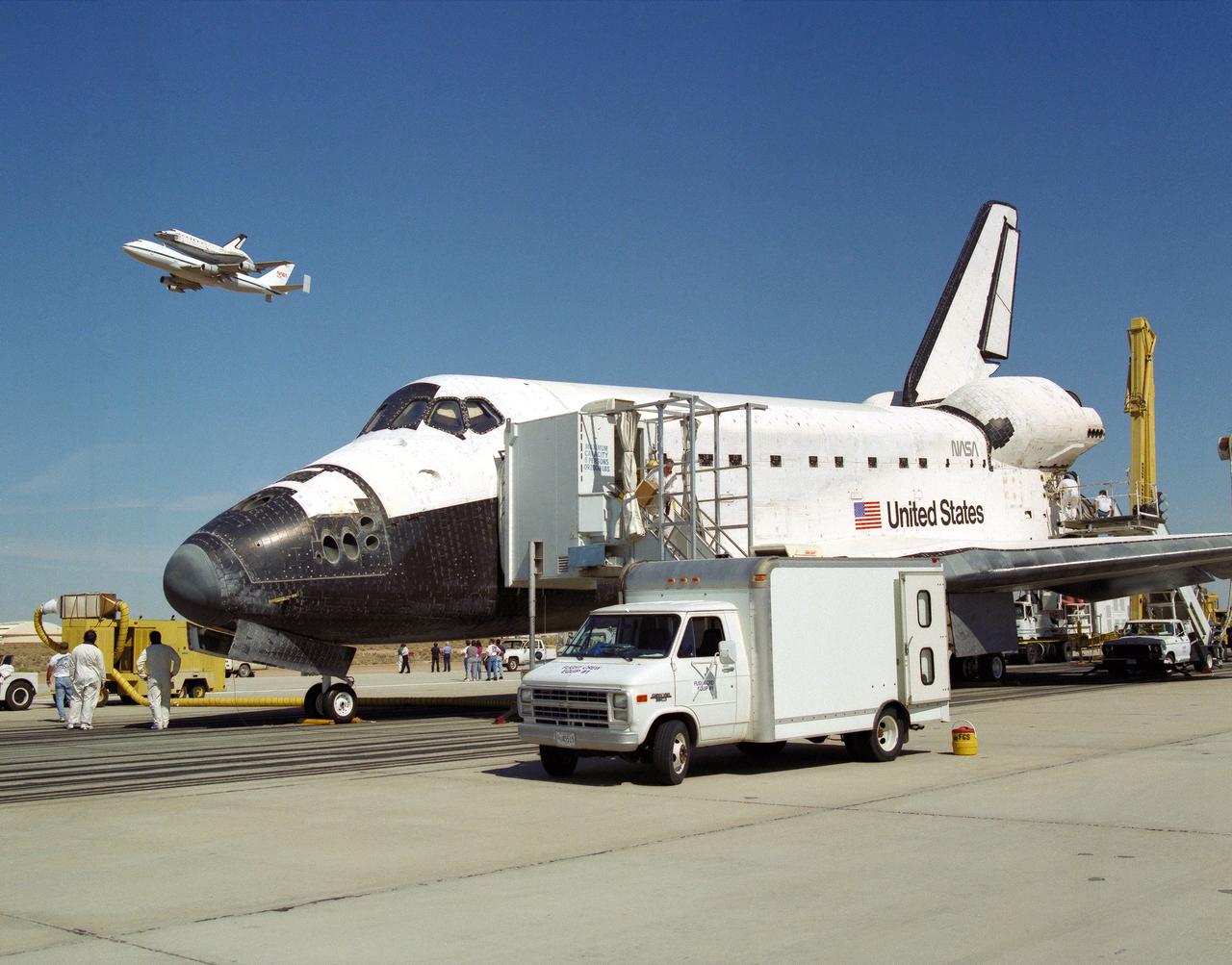
The Space Shuttle Endeavour, atop NASA's 747 Shuttle Carrier Aircraft (SCA), taking off for the Kennedy Space Center shortly after its landing on 11 October 1994, at Edwards, California, to complete mission STS-68. Endeavour was being ferried from the Kennedy Space Center, Florida, to Air Force Plant 42, Palmdale, California, where it will undergo six months of inspections, modifications, and systems upgrades. The STS-68 11-day mission was devoted to radar imaging of Earth's geological features with the Space Radar Laboratory.
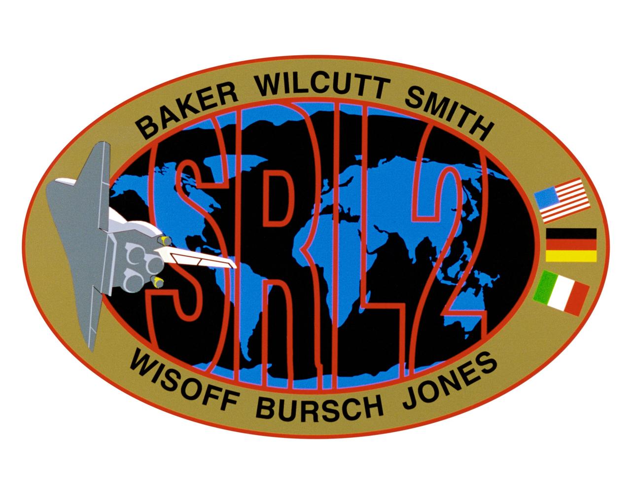
STS068-S-001 (March 1994) --- Exploration of Earth from space is the focus of the design of the STS-68 insignia, the second flight of the Space Radar Laboratory (SRL-2). SRL-2 is part of NASA's Mission to Planet Earth (MTPE) *project. The world's land masses and oceans dominate the center field, with the space shuttle Endeavour circling the globe. The SRL-2 letters span the width and breadth of planet Earth, symbolizing worldwide coverage of the two prime experiments of STS-68 - The Shuttle Imaging Radar-C and X-Band Synthetic Aperture Radar (SIR-C/X-SAR) instruments, and the Measurement of Air Pollution from Satellites (MAPS) sensor. The red, blue and black colors of the insignia represent the three operating wavelengths of SIR-C/X-SAR, and the gold band surrounding the globe symbolizes the atmospheric envelope examined by MAPS. The flags of international partners Germany and Italy are shown opposite Endeavour. The relationship of the orbiter to Earth highlights the usefulness of human spaceflights in understanding Earth's environment, and the monitoring its changing surface and atmosphere. In the words of the crew members, "the soaring orbiter also typifies the excellence of the NASA team in exploring our own world, using the tools which the Space Program developed to explore the other planets in the solar system". This STS-68 patch was designed by artist Sean Collins. The NASA insignia design for space shuttle flights is reserved for use by the astronauts and for other official use as the NASA Administrator may authorize. Public availability has been approved only in the forms of illustrations by the various news media. When and if there is any change in this policy, which is not anticipated, the change will be publicly announced. Photo credit: NASA
This STS-68 patch was designed by artist Sean Collins. Exploration of Earth from space is the focus of the design of the insignia, the second flight of the Space Radar Laboratory (SRL-2). SRL-2 was part of NASA's Mission to Planet Earth (MTPE) project. The world's land masses and oceans dominate the center field, with the Space Shuttle Endeavour circling the globe. The SRL-2 letters span the width and breadth of planet Earth, symbolizing worldwide coverage of the two prime experiments of STS-68: The Shuttle Imaging Radar-C and X-Band Synthetic Aperture Radar (SIR-C/X-SAR) instruments; and the Measurement of Air Pollution from Satellites (MAPS) sensor. The red, blue, and black colors of the insignia represent the three operating wavelengths of SIR-C/X-SAR, and the gold band surrounding the globe symbolizes the atmospheric envelope examined by MAPS. The flags of international partners Germany and Italy are shown opposite Endeavour. The relationship of the Orbiter to Earth highlights the usefulness of human space flights in understanding Earth's environment, and the monitoring of its changing surface and atmosphere. In the words of the crew members, the soaring Orbiter also typifies the excellence of the NASA team in exploring our own world, using the tools which the Space Program developed to explore the other planets in the solar system.
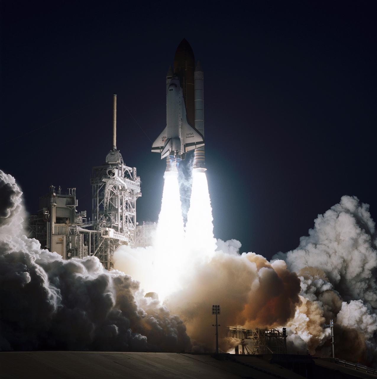
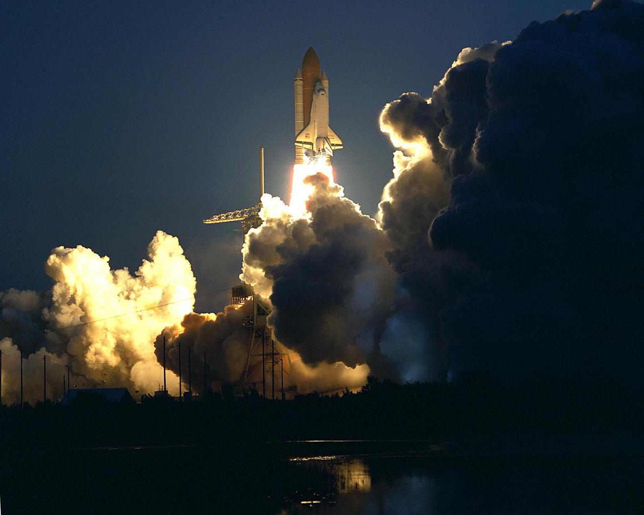
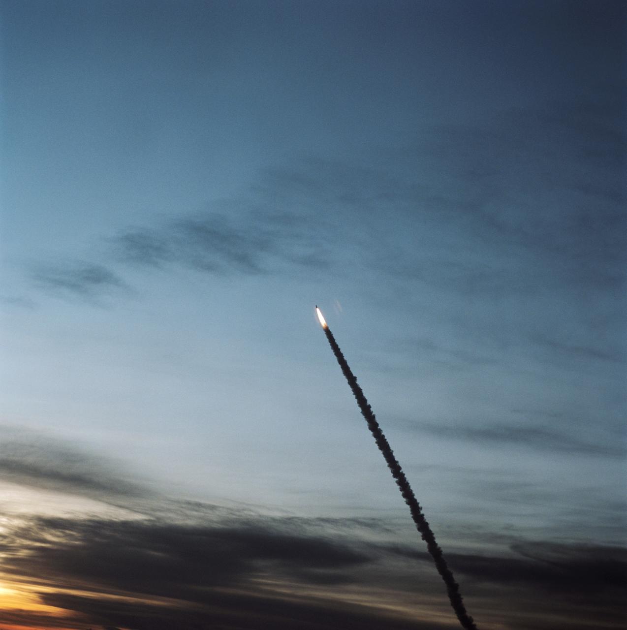
STS068-S-037 (30 September 1994) --- The Space Shuttle Endeavour lifts off from Launch Pad 39A in a halo of light. Aboard for an on time launch at 7:16:00:068 a.m. (EDT) are a crew of six NASA astronauts and the Space Radar Laboratory-2 (SRL-2). Mission commander for the 65th Space Shuttle flight is Michael A. Baker; the pilot is Terrence W. Wilcutt; Thomas D. Jones is the payload commander, and the three mission specialists are Daniel W. Bursch, Steven L. Smith and Peter J. K. "Jeff" Wisoff. During the planned ten-day flight of mission STS-68 around-the-clock operation of the SRL-2 will once again yield a wealth of data about Earth's global environment and the changes - both human-induced and natural - which are affecting it. This is the second flight this year of the SRL, and the second launch try for mission STS-68.
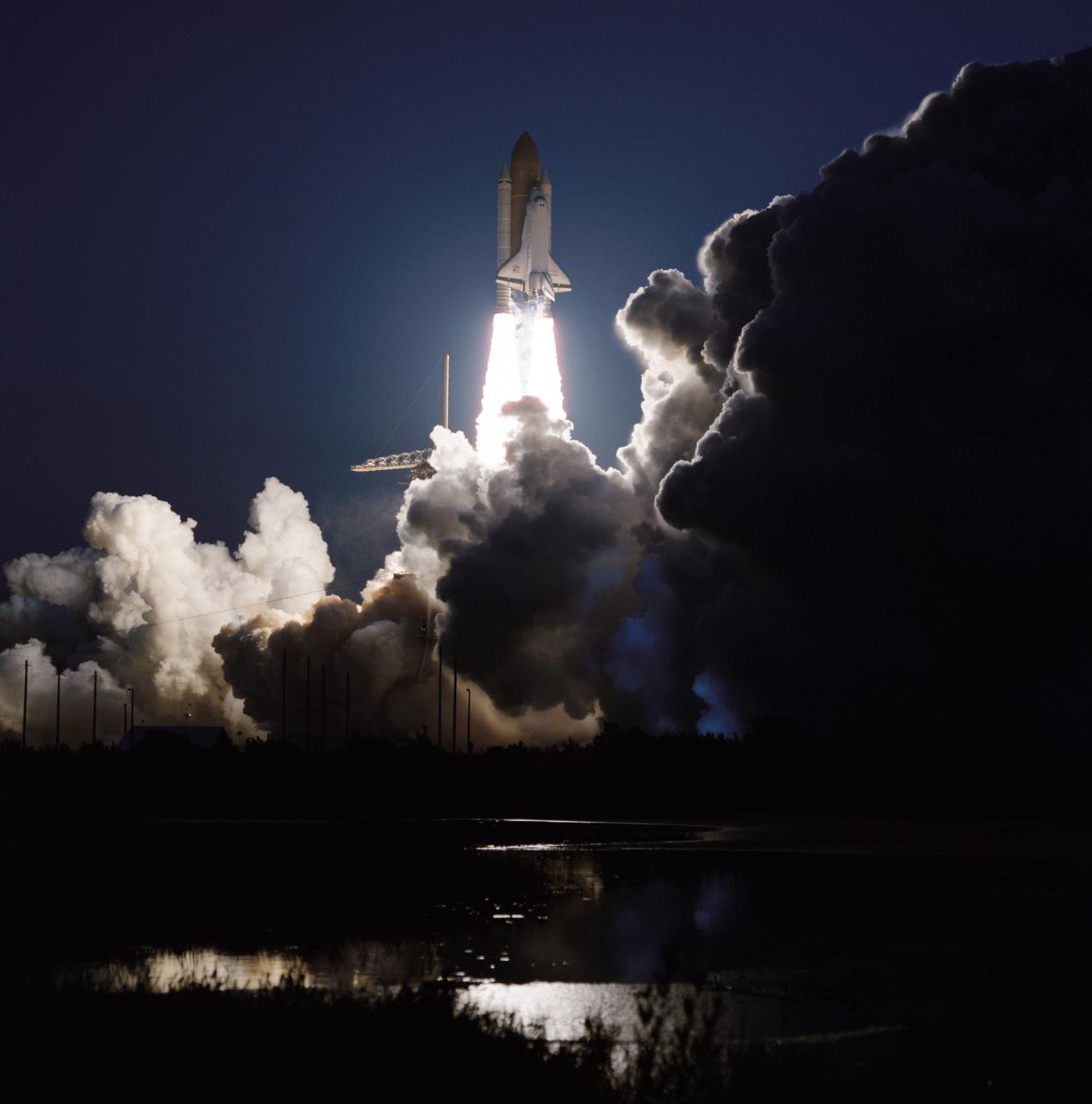
STS068-S-034 (30 September 1994) --- The Space Shuttle Endeavour lifts off from Launch Pad 39A in a halo of light. Aboard for an on time launch at 7:16:00:068 a.m. (EDT) are a crew of six NASA astronauts and the Space Radar Laboratory-2 (SRL-2). Mission commander for the 65th Space Shuttle flight is Michael A. Baker; the pilot is Terrence W. Wilcutt; Thomas D. Jones is the payload commander, and the three mission specialists are Daniel W. Bursch, Steven L. Smith and Peter J. K. "Jeff" Wisoff. During the planned ten-day flight of mission STS-68 around-the-clock operation of the SRL-2 will once again yield a wealth of data about Earth's global environment and the changes - both human-induced and natural - which are affecting it. This is the second flight this year of the SRL, and the second launch try for mission STS-68.
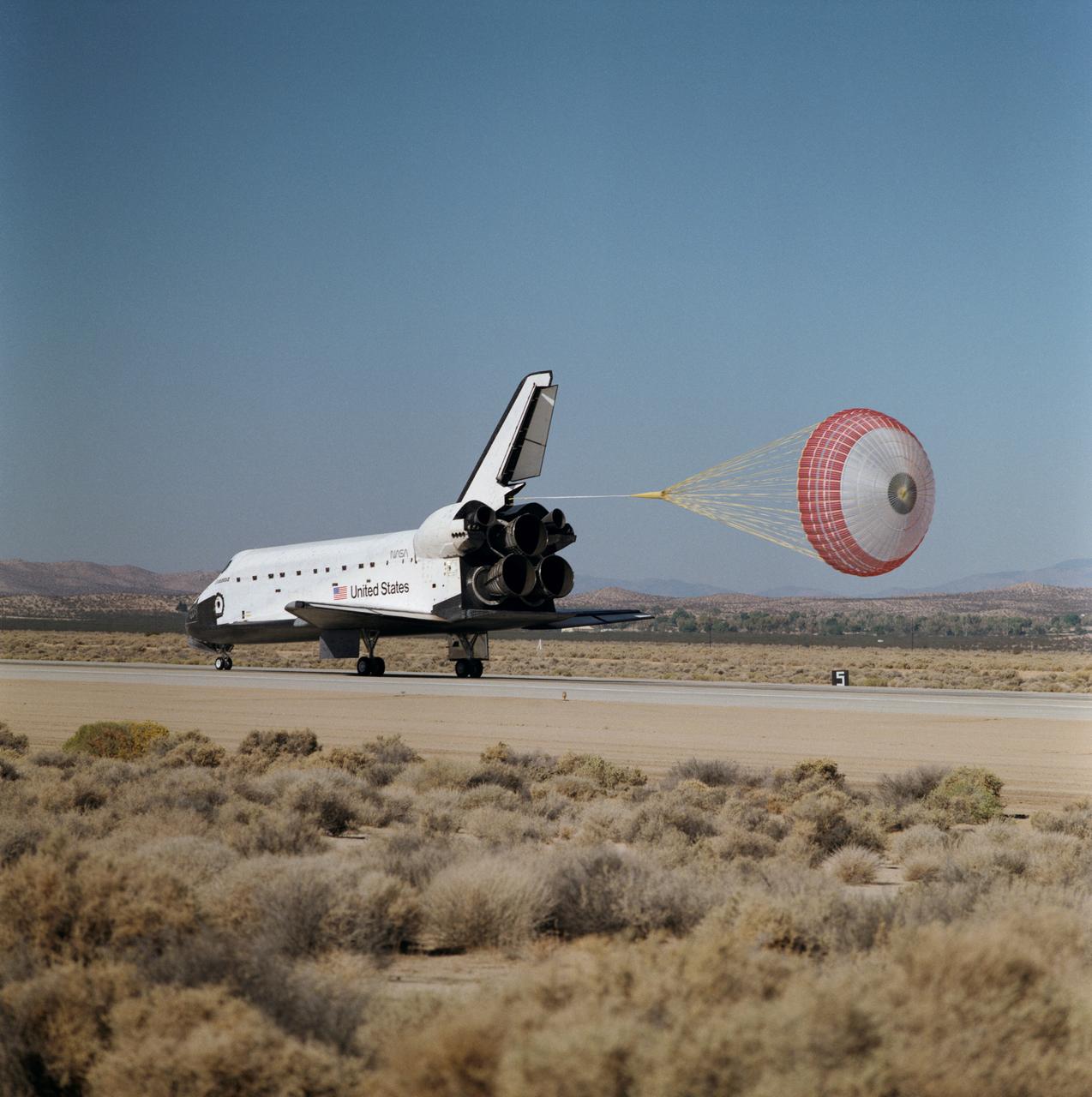
STS068-S-061 (11 October 1994) --- The drag chute system, one of 13 Detailed Test Objectives (DTO) for STS-68, is deployed as the Space Shuttle Endeavour completes an eleven-day mission at Edwards Air Force Base, California. Landing occurred at 10:02 a.m. (PDT), October 11, 1994. Onboard were astronauts Michael A. Baker, mission commander; Terrence W. Wilcutt, pilot; Thomas D. Jones, payload commander; and Daniel W. Bursch, Peter J. K. (Jeff) Wisoff and Steven L. Smith, all mission specialists.
KENNEDY SPACE CENTER, FLA. -- STS-68: Endeavour
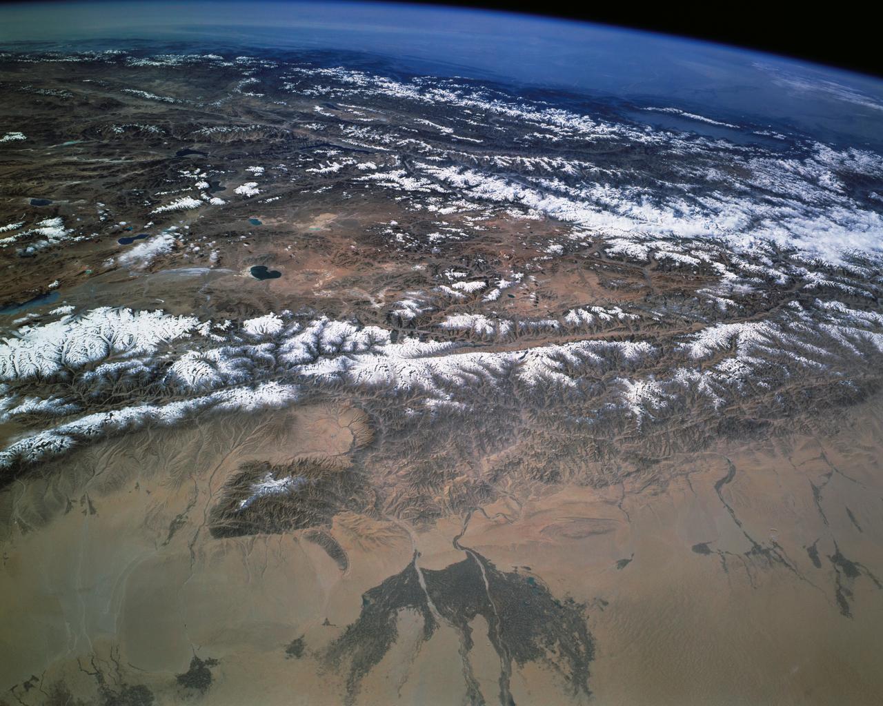
STS068-L158-000C (30 September-11 October 1994) --- This south-looking view shows most of the west end of snow-dusted ranges on the Tibetan Plateau. A major fault line separates the plateau from the low-lying Takla Makan Desert (foreground). The darker areas along two rivers (foreground) make up one of the largest agricultural regions in the Takla Makan Desert. The hazy atmosphere over India (top) contrasts with the thinner, clear air over the plateau. The Vale of Kashmir in northern India is the prominent valley within the first wall of the Himalayan Mountains.
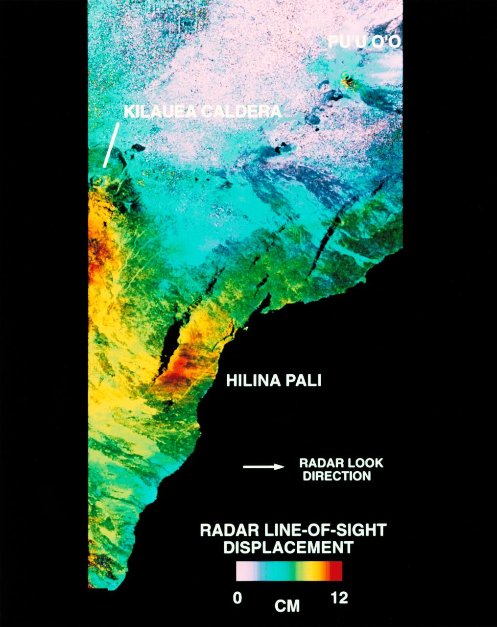
STS068-S-054 (10 October 1994) --- This is a deformation map of the south flank of Kilauea volcano on the big island of Hawaii, centered at 19.5 degrees north latitude and 155.25 degrees west longitude. The map was created by combining interferometric radar data - that is data acquired on different passes of the Space Shuttle Endeavour which are then overlaid to obtain elevation information - acquired by the Spaceborne Imaging Radar-C/X-Band Synthetic Aperture Radar (SIR-C/X-SAR) during its first flight in April 1994 and its second flight in October 1994. The area shown is approximately 40 by 80 kilometers (25 by 50 miles). North is toward the upper left of the image. The colors indicate the displacement of the surface in that direction that the radar instrument was pointed (toward the right of the image) in the six months between images. The analysis of ground movement is preliminary, but appears consistent with the motions detected by the Global Positioning System ground receivers that have been used over the past five years. The south flank of the Kilauea volcano is among the most rapidly deforming terrain's on Earth. Several regions show motion over the six-month time period. Most obvious is at the base of Hilina Pali, where 10 centimeters (4 inches) or more of crustal deformation can be seen in a concentrated area near the coastline. On a more localized scale, the currently active Pu'u O'o summit also shows about 10 centimeters (4 inches) of change near the vent area. Finally, there are indications of additional movement along the upper southwest rift zone, just below the Kilauea caldera in the image. Deformation of the south flank is believed to be the result of movements along faults deep beneath the surface of the volcano, as well as injections of magma, or molten rock, into the volcano's "plumbing" system. Detection of ground motions from space has proven to be a unique capability of imaging radar technology. Scientists hope to use deformation data acquired by SIR-C/X-SAR and future imaging radar missions to help in better understanding the processes responsible for volcanic eruptions and earthquakes. Spaceborne Imaging Radar-C/X-Band Synthetic Aperture Radar (SIR-C/X-SAR) is part of NASA's Mission to Planet Earth. (P-44753)
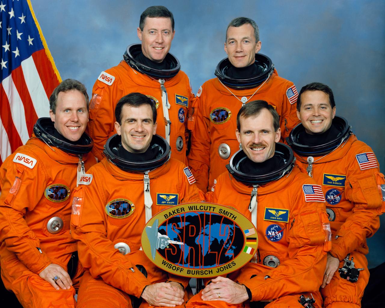
STS068-S-002 (March 1994) --- These six NASA astronauts are in training for the mission, scheduled for launch later this year. Standing are, left to right, Michael A. Baker, mission commander; and Terrence W. Wilcutt, pilot. On the front row are, left to right, Thomas D. Jones, payload commander; and Peter J. K. (Jeff) Wisoff, Steven L. Smith and Daniel W. Bursch, all mission specialists.
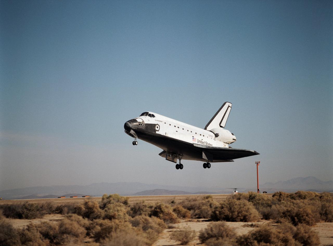
STS068-S-060 (11 October 1994) --- With its main landing gear not quite on the runway, the Space Shuttle Endeavour wraps up an eleven-day mission at Edwards Air Force Base, California. Landing occurred at 10:02 a.m. (PDT), October 11, 1994. Onboard were astronauts Michael A. Baker, mission commander; Terrence W. Wilcutt, pilot; Thomas D. Jones, payload commander; and Daniel W. Bursch, Peter J. K. (Jeff) Wisoff and Steven L. Smith, all mission specialists.
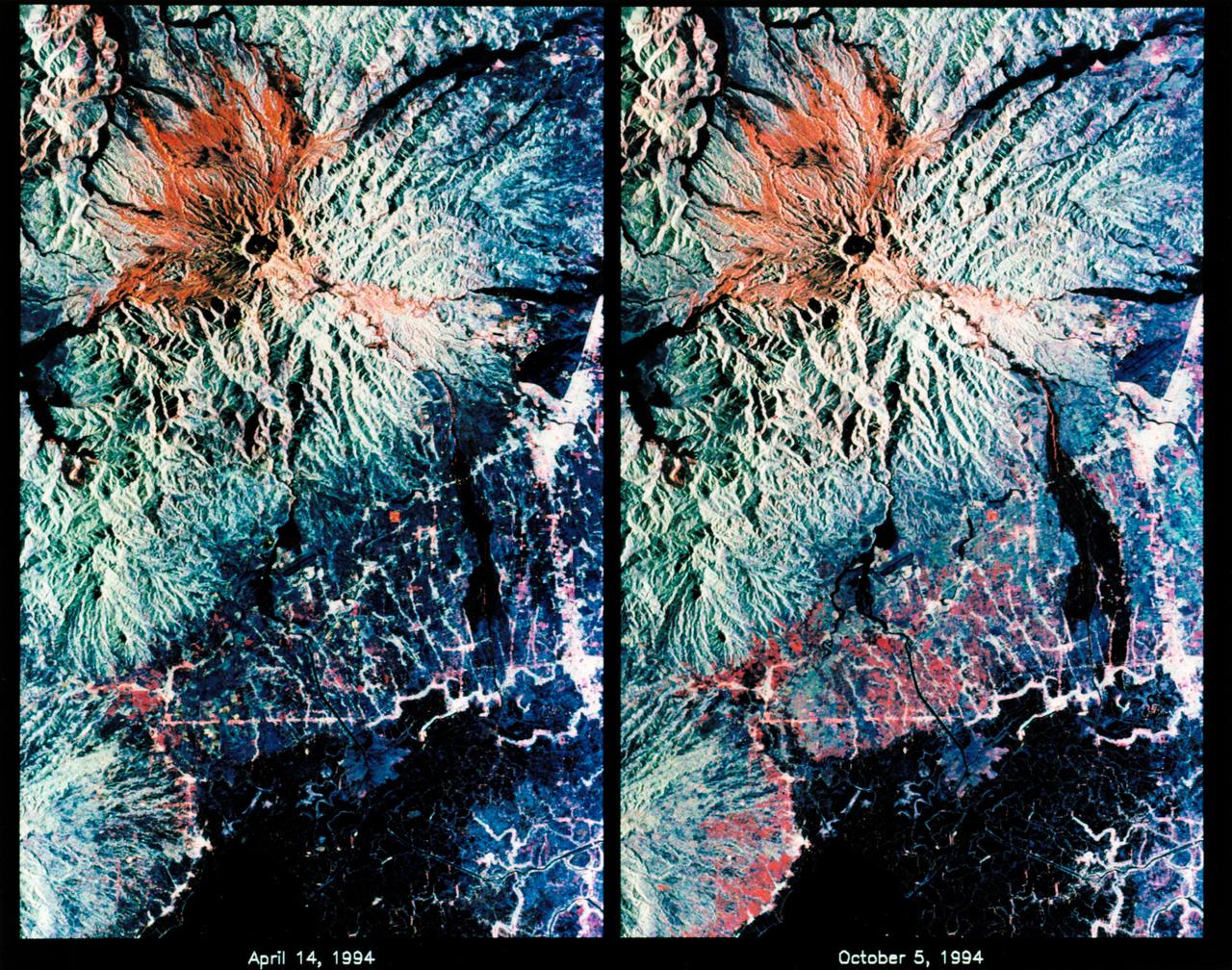
STS068-S-053 (7 October 1994) --- These are color composite radar images showing the area around Mount Pinatubo in the Philippines. The images were acquired by the Spaceborne Imaging Radar-C/X-Band Synthetic Aperture Radar (SIR-C/X-SAR) aboard the Space Shuttle Endeavour on April 14, 1994 (left image) and October 5, 1994 (right image). The images are centered at about 15 degrees north latitude and 120.5 degrees east longitude. Both images were obtained with the same viewing geometry. The color composites were made by displaying the L-Band (horizontally transmitted and received) in red; the L-Band (horizontally transmitted and vertically received) in green; and the C-Band (horizontally transmitted and vertically received) in blue. The area shown is approximately 40 by 65 kilometers (25 by 40 miles). The main volcanic crater on Mount Pinatubo produced by the June 1991 eruptions and the steep slopes on the upper flanks of the volcano are easily seen in these images. Red on the high slopes shows the distribution of the ash deposited during the 1991 eruption, which appears red because of the low cross-polarized radar returns at C and L Bands. The dark drainage's radiating away from the summit are smooth mud flows, which even three years after the eruption continue to flood the river valleys after heavy rain. Comparing the two images shows that significant changes have occurred in the intervening five months along the Pasig-Potero rivers (the dark area in the lower right of the images). Mud flows, called "lahars", that occurred during the 1994 monsoon season filled the river valleys, allowing the lahars to spread over the surrounding countryside. Three weeks before the second image was obtained, devastating lahars more than doubled the area affected in the Pasig-Potero rivers, which is clearly visible as the increase in dark area on the lower right of the images. Migration of deposition to the east (right) has affected many communities. Newly affected areas included the community of Bacolor, Pampanga, where thousands of homes were buried in meters of hot mud and rock as 80,000 people fled the lahar-stricken area. The 1991 Mount Pinatubo eruption is well known for its near-global effects on the atmosphere and short-term climate due to the large amount of sulfur dioxide that was injected into the upper atmosphere. Locally, however, the effects will most likely continue to impact surrounding areas for as long as the next 10 to 15 years. Mud flows, quite certainly, will continue to pose severe hazards to adjacent areas. Radar observations like those obtained by SIR-C/X-SAR will play a key role in monitoring these changes because of the radar's ability to see daylight or darkness and even in the worst weather conditions. Radar imaging will be particularly useful during the monsoon season, when the lahars form. Frequent imaging of these lahar fields will allow scientists to better predict when they are likely to begin flowing again and which communities might be at risk. Spaceborne Imaging Radar-C/X-Band Synthetic Aperture Radar (SIR-C/X-SAR) is part of NASA's Mission to Planet Earth. (P-44729)
STS068-S-027 (30 September 1994) --- The Space Shuttle Endeavour, with six NASA astronauts and a battery of Earth-monitoring systems aboard, heads toward Earth orbit. Launch occurred at 7:16 a.m. (EDT), September 30, 1994. The view was photographed from the Shuttle Training Aircraft (STA) by astronaut Robert D. Cabana, who was piloting the aircraft and monitoring environmental conditions for launch.
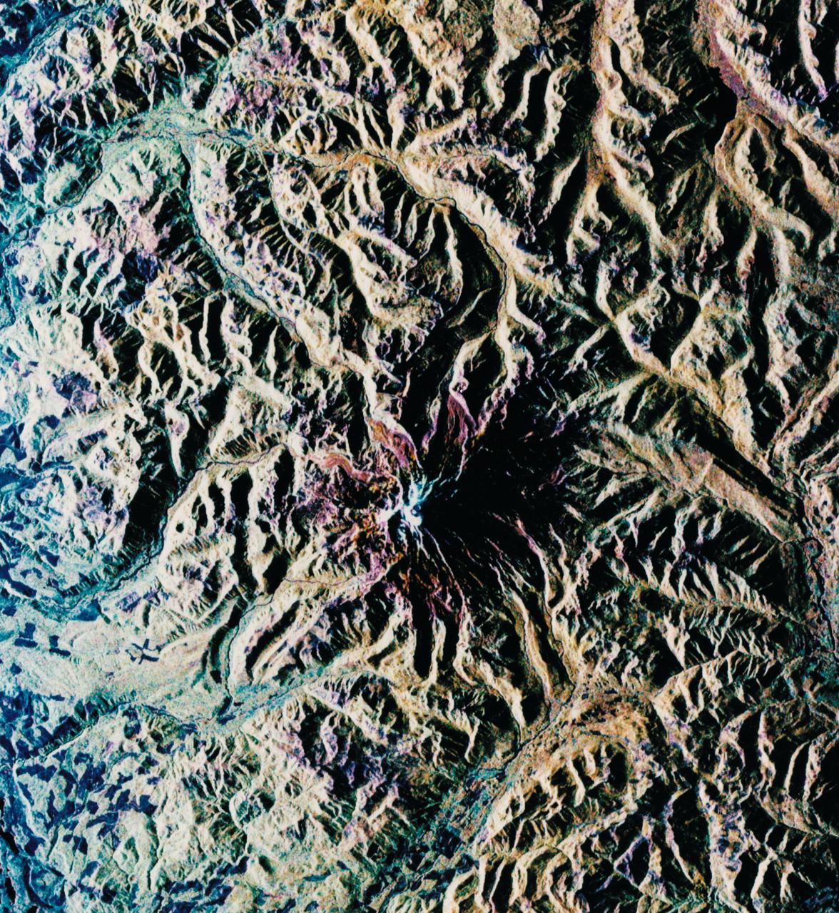
STS068-S-052 (3 October 1994) --- This is a radar image of Mount Rainier in Washington state. The volcano last erupted about 150 years ago and numerous large floods and debris flows have originated on its slopes during the last century. Today the volcano is heavily mantled with glaciers and snow fields. More than 100,000 people live on young volcanic mud flows less than 10,000 years old and, are within the range of future, devastating mud slides. This image was acquired by the Spaceborne Imaging Radar-C/X-Band Synthetic Aperture Radar (SIR-C/X-SAR) aboard the Space Shuttle Endeavour on its 20th orbit on October 1, 1994. The area shown in the image is approximately 59 by 60 kilometers (36.5 by 37 miles). North is toward the top left of the image, which was composed by assigning red and green colors to the L-Band, horizontally transmitted and vertically, and the L-Band, horizontally transmitted and vertically received. Blue indicates the C-Band, horizontally transmitted and vertically received. In addition to highlighting topographic slopes facing the Space Shuttle, SIR-C records rugged areas as brighter and smooth areas as darker. The scene was illuminated by the Shuttle's radar from the northwest so that northwest-facing slopes are brighter and southeast-facing slopes are dark. Forested regions are pale green in color, clear cuts and bare ground are bluish or purple; ice is dark green and white. The round cone at the center of the image is the 14,435 feet (4,399 meters) active volcano, Mount Rainier. On the lower slopes is a zone of rock ridges and rubble (purple to reddish) above coniferous forests (in yellow/green). The western boundary of Mount Rainier National Park is seen as a transition from protected, old-growth forest to heavily logged private land, a mosaic of recent clear cuts (bright purple/blue) and partially re-grown timber plantations (pale blue). The prominent river seen curving away from the mountain at the top of the image (to the northwest) is the White River, and the river leaving the mountain at the bottom right of the image (south) is the Nisqually River, which flows out of the Nisqually glacier on the mountain. The river leaving to the left of the mountain is the Carbon River, leading west and north toward heavily populated regions near Tacoma. The dark patch at the top right of the image is Bumping Lake. Other dark areas seen to the right of ridges throughout the image are radar shadow zones. Radar images can be used to study the volcanic structure and the surrounding regions with linear rock boundaries and faults. In addition, the recovery of forested lands from natural disasters and the success of re-forestation programs can also be monitored. Ultimately this data may be used to study the advance and retreat of glaciers and other forces of global change. Spaceborne Imaging Radar-C/X-Band Synthetic Aperture Radar (SIR-C/X-SAR) is part of NASA's Mission to Planet Earth. (P-44703)
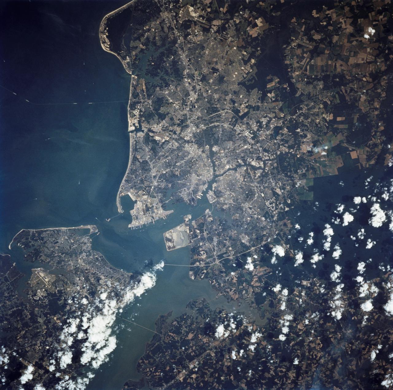
STS068-237-055 (30 September - 11 October 1994) --- This coastal area, considered home by astronaut Peter J. K. (Jeff) Wisoff, was photographed from the Space Shuttle Endeavour during the Space Radar Laboratory (SRL-2) mission. Wisoff, a native of Norfolk, talked about this area during a post-flight crew awards and presentation event at the Johnson Space Center (JSC). He pointed out that the waterways are heavily used for commercial, recreational and military purposes. Piers near the mouth of the Elizabeth River are associated with the U. S. Naval Base and those down river support the activities of the city of Norfolk. Seashore State Park and the Ft. Story Military Reservation are visible at the mouth of the Chesapeake.
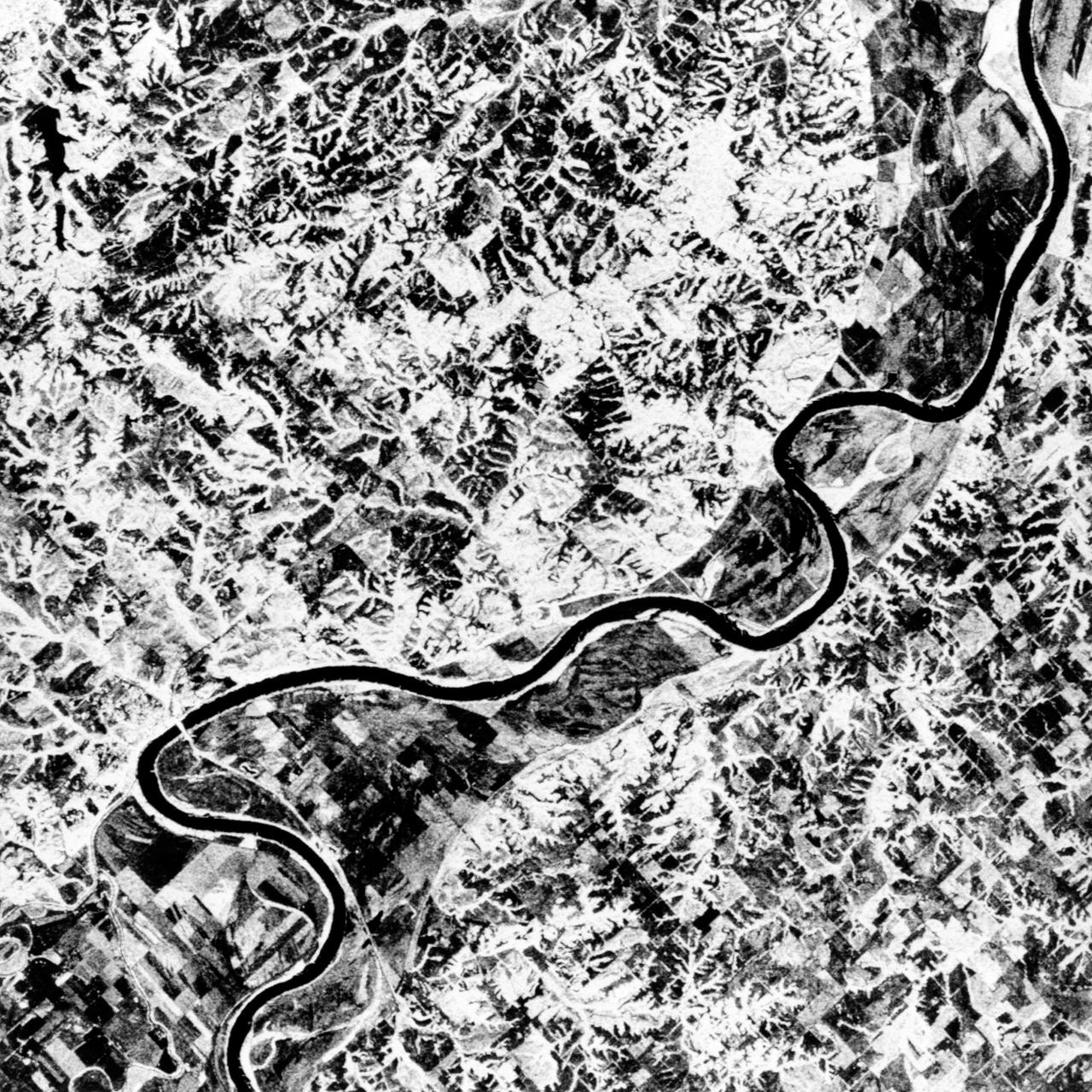
STS068-S-055 (7 October 1994) --- This is a false-color L-Band image of an area near Glasgow, Missouri, centered at about 39.2 degrees north latitude and 92.8 degrees west longitude. The image was acquired using the L-Band radar channel (horizontally transmitted and received and horizontally transmitted and vertically received) polarization's combined. The data were acquired by the Spaceborne Imaging Radar-C/X-Band Synthetic Aperture Radar (SIR-C/X-SAR) aboard the Space Shuttle Endeavour on orbit 50 on October 3, 1994. The area shown is approximately 37 by 25 kilometers (23 by 16 miles). The radar data, coupled with pre-flood aerial photography and satellite data and post-flood topographic and field data, are being used to evaluate changes associated with levee breaks in land forms, where deposits formed during the widespread flooding in 1993 along the Missouri and Mississippi Rivers. The distinct radar scattering properties of farmland, sand fields and scoured areas will be used to inventory flood plains along the Missouri River and determine the processes by which these areas return to preflood conditions. The image shows one such levee break near Glasgow, Missouri. In the upper center of the radar image, below the bend of the river, is a region covered by several meters of sand, shown as dark regions. West (left) of the dark areas, a gap in the levee tree canopy shows the area where the levee failed. Radar data such as these can help scientists more accurately assess the potential for future flooding in this region and how that might impact surrounding communities. Spaceborne Imaging Radar-C/X-Band Synthetic Aperture Radar (SIR-C/X-SAR) is part of NASA's Mission to Planet Earth. The radars illuminate Earth with microwaves, allowing detailed observations at any time, regardless of weather or sunlight conditions. SIR-C/X-SAR uses the three microwave wavelengths: the L-Band (24 centimeters), C-Band (6 centimeters) and X-Band (3 centimeters). The multi-frequency data will be used by the international scientific community to better understand the global environment and how it is changing. The SIR-C/X-SAR data, complemented by aircraft and ground studies, will give scientists clearer insights into those environmental changes which are caused by nature and those changes which are induced by human activity. SIR-C was developed by NASA's Jet Propulsion Laboratory (JPL). X-SAR was developed by the Dornier and Alenia Spazio companies for the German space agency, Deutsche Agentur fuer Raumfahrtangelegenheiten (DARA), and the Italian space agency, Agenzia Spaziale Italiana (ASI), with the Deutsche Forschungsanstalt fuer Luft und Raumfahrt e.v. (DLR), the major partner in science, operations and data processing of X-SAR. (P-44734)
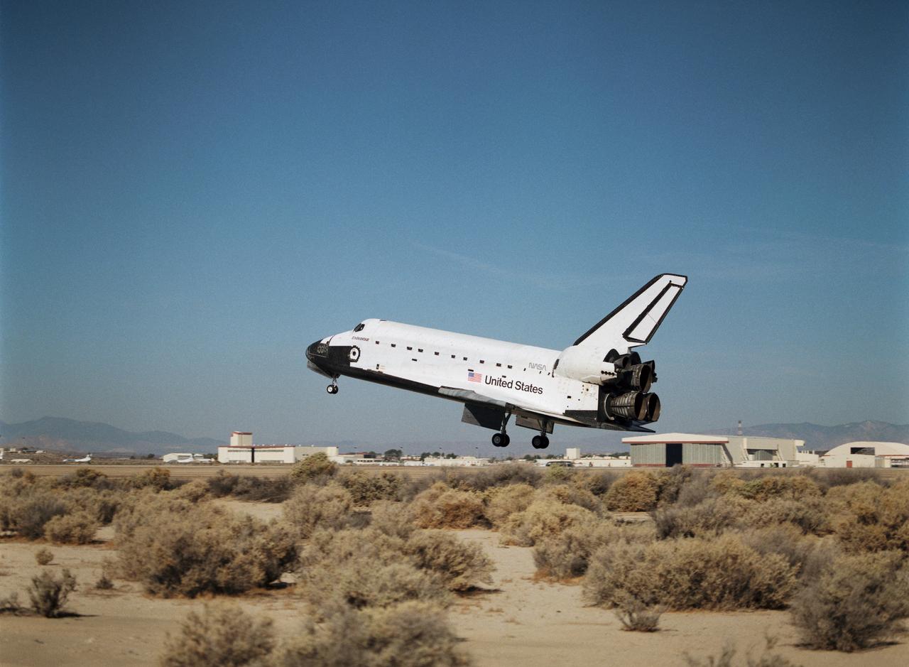
STS068-S-059 (11 October 1994) --- With its main landing gear not quite on the runway, the Space Shuttle Endeavour wraps up an eleven-day mission at Edwards Air Force Base, California. Landing occurred at 10:02 a.m. (PDT), October 11, 1994. Onboard were astronauts Michael A. Baker, mission commander; Terrence W. Wilcutt, pilot; Thomas D. Jones, payload commander; and Daniel W. Bursch, Peter J. K. (Jeff) Wisoff and Steven L. Smith, all mission specialists.

STS-89 Commander Terrence Wilcutt smiles as he completes the donning of his launch/entry suit in the Operations and Checkout (O&C) Building. A veteran of two space flights, he has logged more than 512 hours in space. He served as pilot on STS-68 and STS-79. He and six fellow crew members will soon depart the O&C and head for Launch Pad 39A, where the Space Shuttle Endeavour will lift off during a launch window that opens at 9:43 p.m. EST, Jan. 22. STS-89 is the eighth of nine planned missions to dock the Space Shuttle with Russia's Mir space station
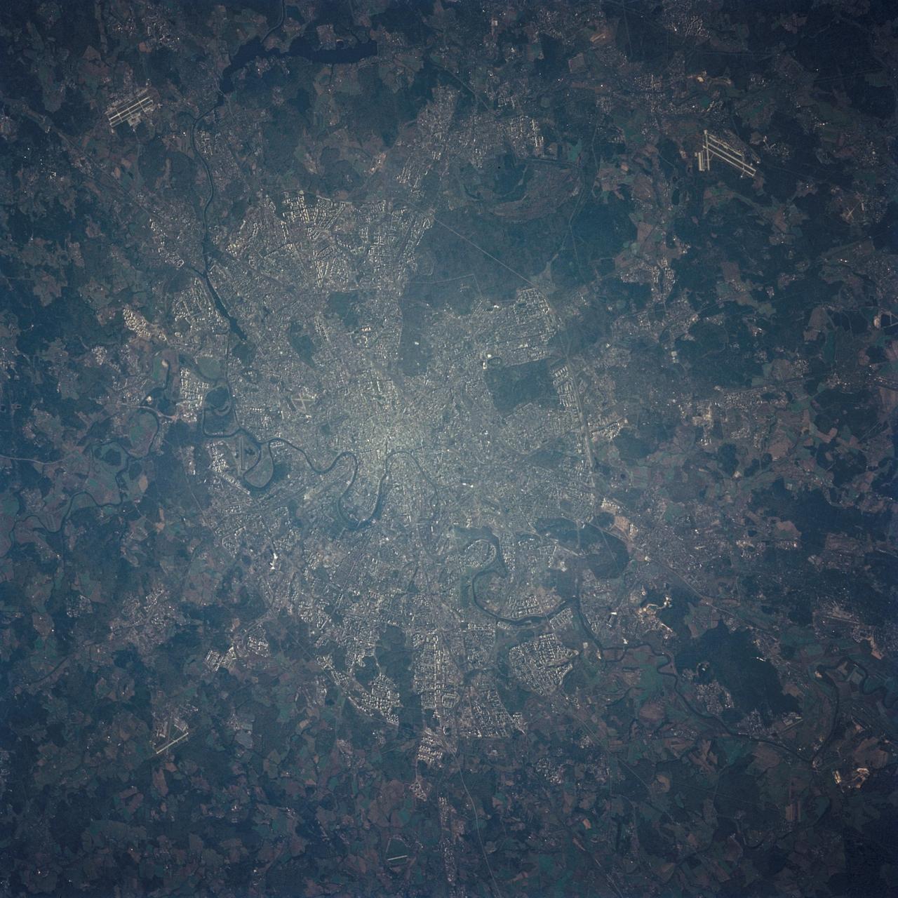
STS068-236-027 (30 September-11 October 1994) --- The STS-68 crewmembers used a 70mm camera to photograph this early morning nadir view of wheel-shaped Moscow. Star City, Russia facility, north of the city, is among the detail seen in the view, photographed from 115 nautical miles above Earth. Six NASA astronauts spent a week and a half aboard the Space Shuttle Endeavour in support of the Space Radar Laboratory 2 (SRL-2) mission.
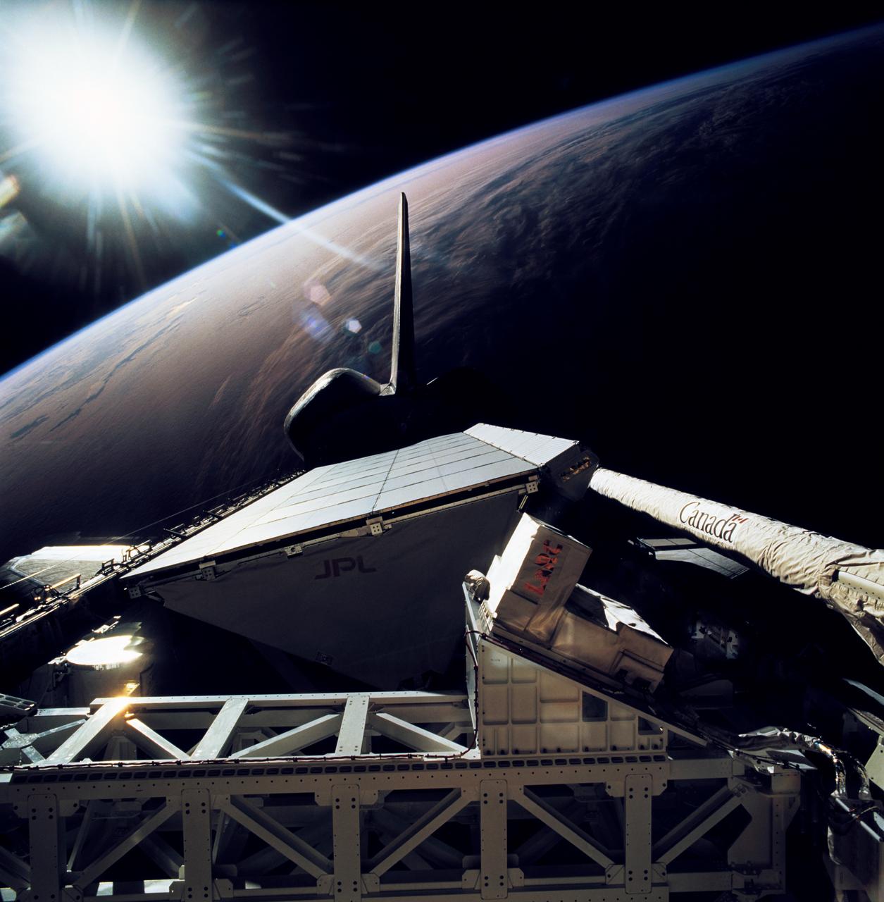
STS068-267-079 (30 September-11 October 1994) --- The rear windows of the Space Shuttle Endeavour reflect sunlight in this view of part of the cargo bay, 115 nautical miles above the Earth. The Space Radar Laboratory (SRL-2) Multipurpose Experiment Support Structure (MPESS) is seen at bottom frame. Also partially seen are other experiments including other components of the primary payload. They are the antenna for the Spaceborne Imaging Radar (SIR-C), the X-band Synthetic Aperture Radar (X-SAR), the device for Measurement of Air Pollution from Satellites (MAPS) and some Getaway Special (GAS) canisters.
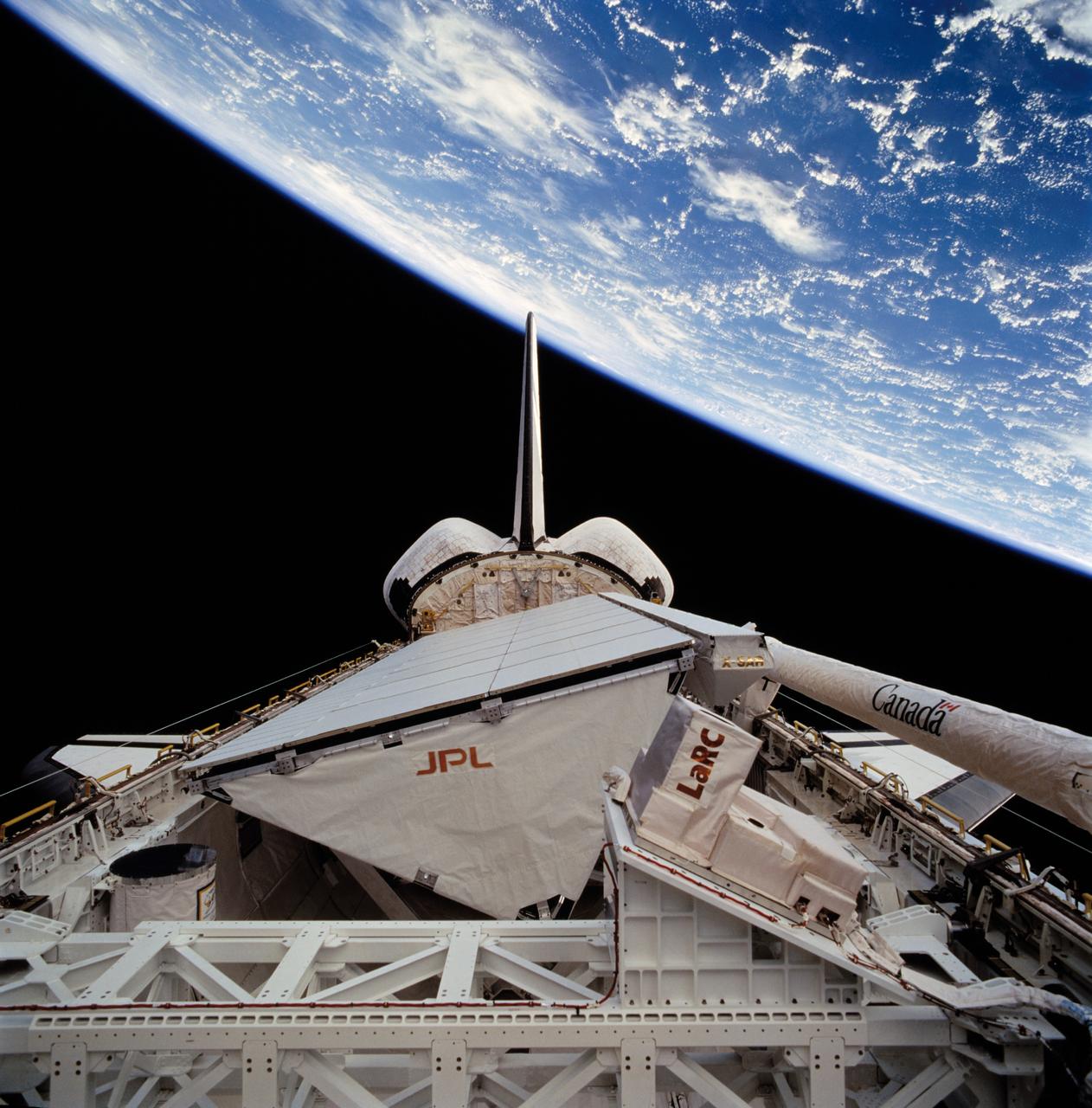
STS068-272-075 (30 September-11 October 1994) --- The darkness of space forms the backdrop for this scene of the Space Shuttle Endeavour's cargo bay, 115 nautical miles above a cloud covered Indian Ocean. The Space Radar Laboratory (SRL-2) Multipurpose Experiment Support Structure (MPESS) is seen at bottom frame. Also partially seen are other experiments including other components of the primary payload. They are the antenna for the Spaceborne Imaging Radar (SIR-C), the X-band Synthetic Aperture Radar (X-SAR), the device for Measurement of Air Pollution from Satellites (MAPS) and some Getaway Special (GAS) canisters.
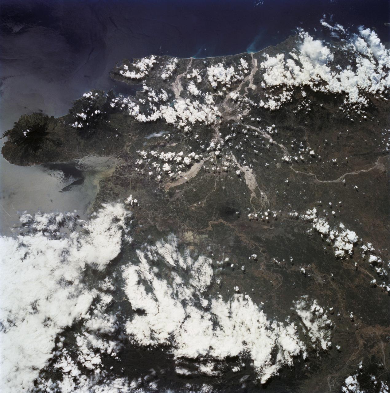
STS068-232-083 (30 September-11 October 1994) --- This is a view of Mount Pinatubo, Philippine Islands, orient with the coast to the top. View westward across central Luzon and Mount Pinatubo. Manilla Bay is in partial sunglint along the left edge of the frame. The extensive flows of volcanic ash (lahars) extending from the mountain are readily seen despite partial cloud cover. The ash is mobilized with every rain in this typhoon-ridden region, flowing down valleys, filling drainage channels, and covering fields and towns. The STS-68 crew obtained excellent photographs of the region, for comparison to the radar data also obtained on the mission. Photographs in sunglint have proven particularly helpful because they show the exact outlines of surface water, which provides a datum point for the radar returns.