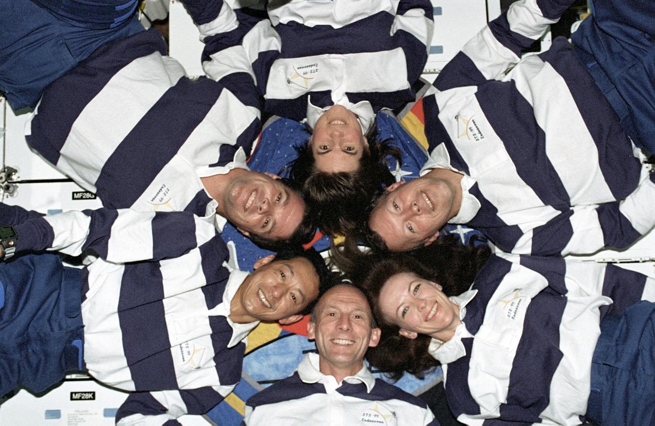
The STS-99 crew pose for a "star-burst" pose in celebration of a successful Shuttle Radar Topographic Mission (SRTM) aboard NASA's Space Shuttle Endeavor. Clockwise, around the circle, from top center are astronauts Janice Voss, Dominic L. Gorie, Janet L. Kavandi, Gerhard Thiele of the European Space Agency, Mamoru Mohri of the Japanese Space Agency, and Kevin Kregel. The STS-99 SRTM mission was the most ambitious Earth mapping mission to date. Orbiting at 233 kilometers (145 miles) above Earth, two radar anternas, one located in the Shuttle bay and the other located on the end of a 60-meter deployable mast, was used during the mission to map Earth's features. The goal was to provide a 3-dimensional topographic map of the world's surface up to the Arctic and Antarctic Circles. The mission completed 222 hours of around the clock radar mapping gathering enough information to fill more than 20,000 CDs.
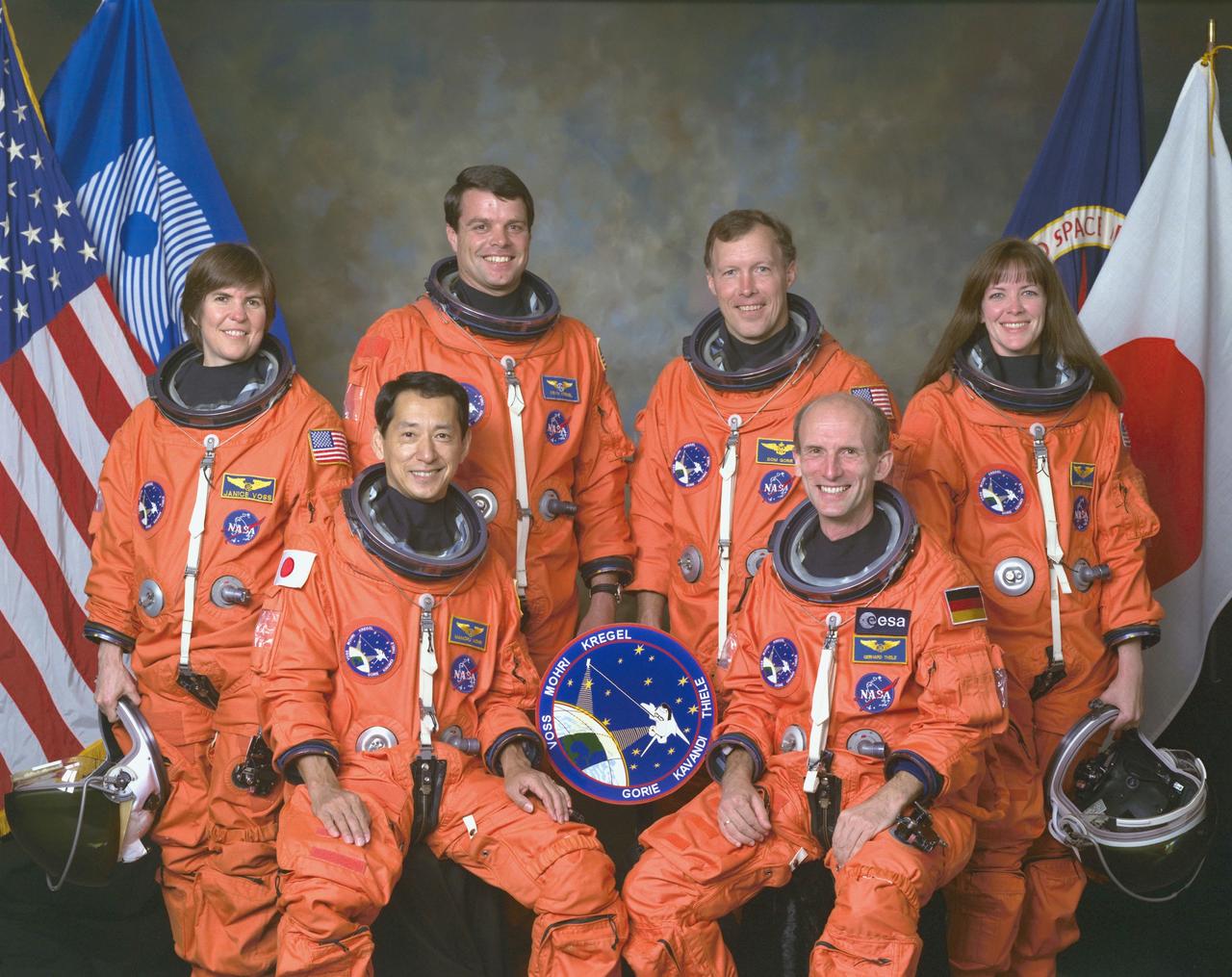
An international crew assigned to STS-99 takes a break from training to pose for the traditional crew portrait at NASA's Johnson Space Center (JSC). In front are international astronauts and mission specialists Mamoru Mohri, representing Japan's Space Agency (NASDA), and Gerhard P. J. Thiele of Germany, representing the European Space Agency (ESA). In back are astronauts Janice Voss, mission specialist; Kevin R. Kregel, mission commander; Dominic L. Gorie, pilot; and Janet L. Kavandi, mission specialist. STS-99 was a Shuttle Radar Topography Mission (SRTM), the most ambitious Earth mapping mission to date. Two radar anternas, one located in the Shuttle bay and the other located on the end of a 60-meter deployable mast, was used during the mission to map Earth's features. The goal was to provide a 3-dimensional topographic map of the world's surface up to the Arctic and Antarctic Circles. Launched aboard the Space Shuttle Endeavor on February 11, 2000, the 11-day mission provided enough information to fill more than 20,000 CDs.
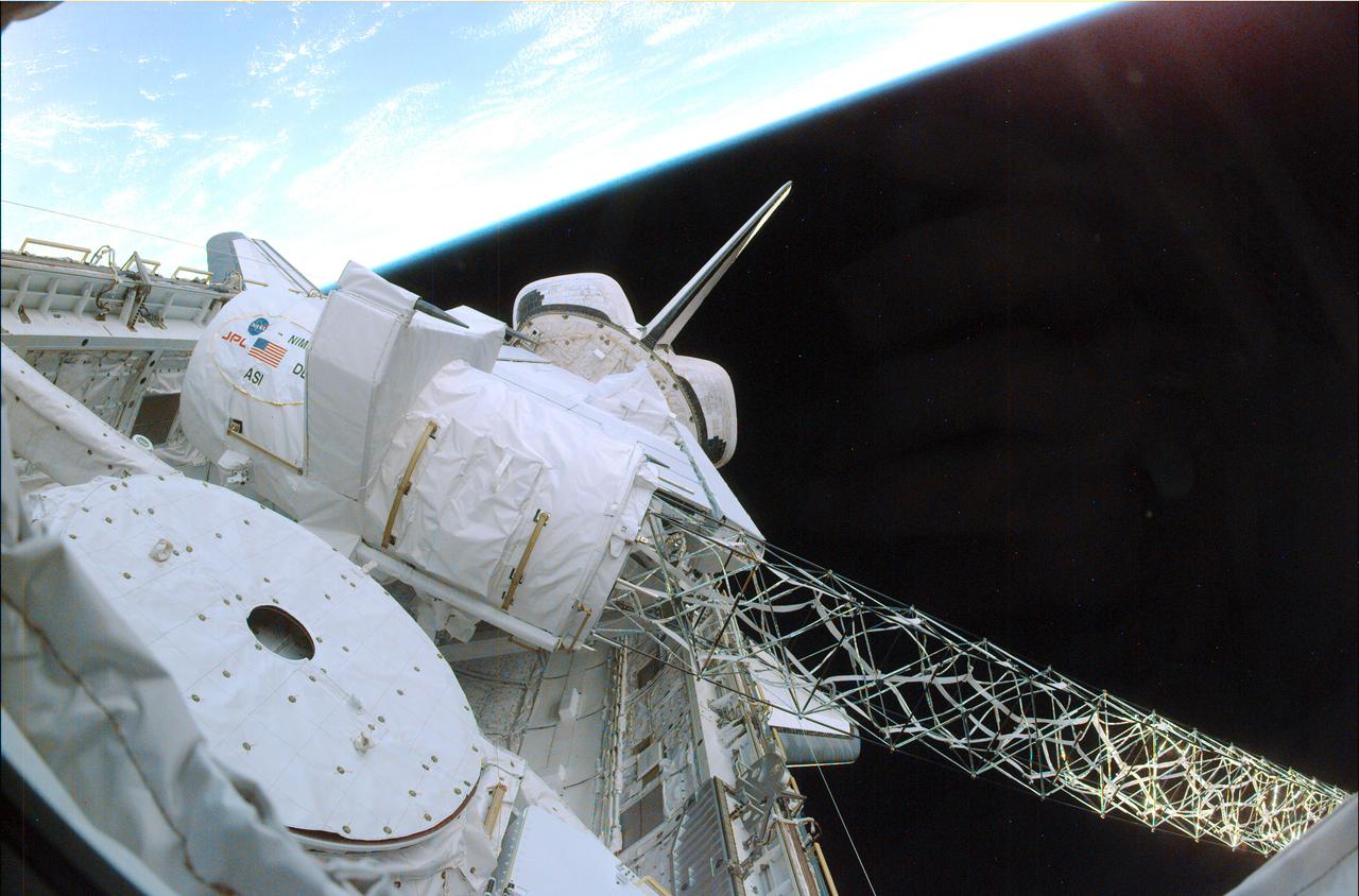
Launched February 11, 2000, the STS-99 Shuttle Radar Topographic Mission (SRTM) was the most ambitious Earth mapping mission to date. A 200-ft long (60 meter) mast supporting the SRTM where it jutted into space from the Space Shuttle Endeavour. In this photograph, part of the SRTM hardware is shown in the payload bay of the shuttle. Orbiting some 145 miles (233 kilometers) above Earth, the giant structure was deployed on February 12, 2000 and the C-band and X-band anternae mounted on it quickly went to work mapping parts of the Earth. The SRTM radar was able to penetrate clouds as well as provide its own illumination, independent of daylight, obtaining3-dimentional topographic images of the world's surface up to the Arctic and Antarctic Circles. The mission completed 222 hours of around the clock radar mapping gathering enough information to fill more than 20,000 CDs.
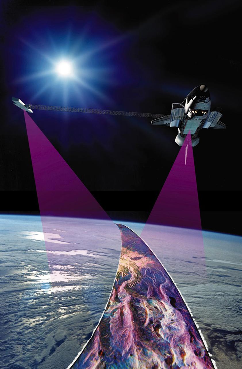
Launched February 11, 2000, the STS-99 Shuttle Radar Topographic Mission (SRTM) was the most ambitious Earth mapping mission to date. This illustration shows the Space Shuttle Endeavour orbiting some 145 miles (233 kilometers) above Earth. With C-band and X-band outboard anternae at work, one located in the Shuttle bay and the other located on the end of a 60-meter deployable mast, the SRTM radar was able to penetrate clouds as well as provide its own illumination, independent of daylight, obtaining 3-dimentional topographic images of the world's surface up to the Arctic and Antarctic Circles. The mission completed 222 hours of around the clock radar mapping, gathering enough information to fill more than 20,000 CDs.
The Space Shuttle Orbiter Endeavour blasts form the launch pad on February 11, 2000 carrying its crew of six for the STS-99 mission, a Shuttle Radar Topography Mission (SRTM), the most ambitious Earth mapping mission to date. Orbiting at 233 kilometers (145 miles) above Earth, two radar anternas, one located in the Shuttle bay and the other located on the end of a 60-meter deployable mast, was used during the mission to map Earth's features. The goal was to provide a 3-dimensional topographic map of the world's surface up to the Arctic and Antarctic Circles. The mission completed 222 hours of around the clock radar mapping gathering enough information to fill more than 20,000 CDs.
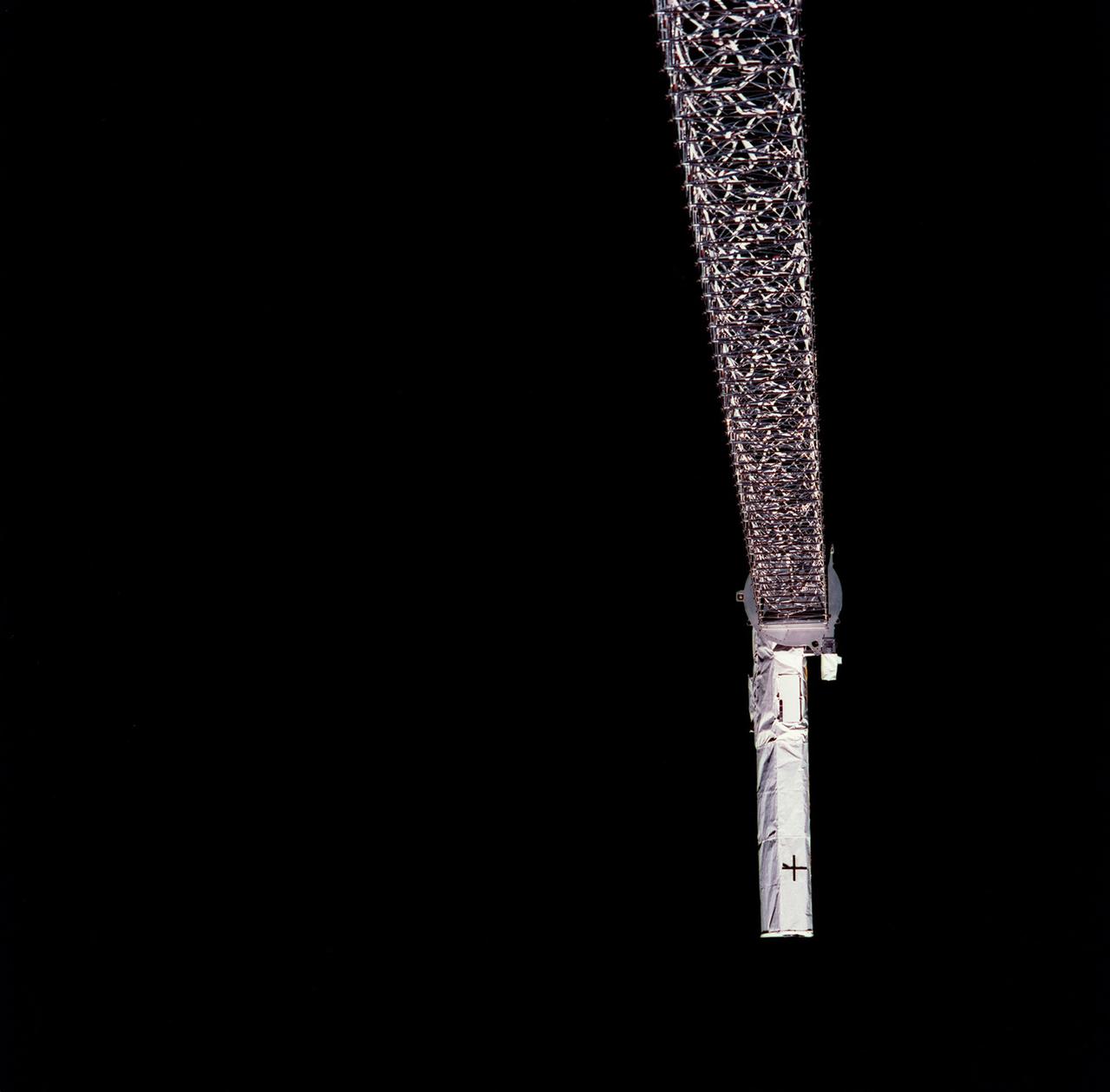
Launched February 11, 2000, the STS-99 Shuttle Radar Topographic Mission (SRTM) was the most ambitious Earth mapping mission to date. This photograph shows a 200-ft long (60 meter) mast supporting the SRTM jutted into space from the Space Shuttle Endeavour (out of frame). Orbiting some 145 miles (233 kilometers) above Earth, the giant structure was deployed on February 12, 2000 and its C-band and X-band anternae quickly went to work mapping parts of the Earth. The outboard antennae can be seen near bottom right. The SRTM radar was able to penetrate clouds as well as provide its own illumination, independent of daylight, and obtained 3-dimentional topographic images of the world's surface up to the Arctic and Antarctic Circles. The mission completed 222 hours of around the clock radar mapping, gathering enough information to fill more than 20,000 CDs.
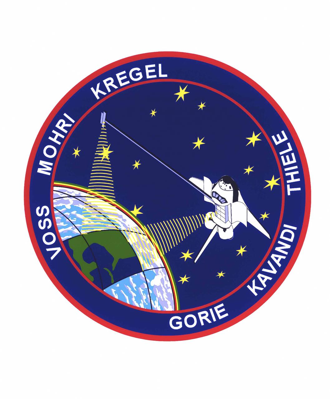
The STS-99 crew members designed the flight insignia for the Shuttle Radar Topography Mission (SRTM), the most ambitious Earth mapping mission to date. Two radar anternas, one located in the Shuttle bay and the other located on the end of a 60-meter deployable mast, was used during the mission to map Earth's features. The goal was to provide a 3-dimensional topographic map of the world's surface up to the Arctic and Antarctic Circles. In the patch, the clear portion of Earth illustrates the radar beams penetrating its cloudy atmosphere and the unique understanding of the home planet that is provided by space travel. The grid on Earth reflects the mapping character of the SRTM mission. The patch depicts the Space Shuttle Endeavour orbiting Earth in a star spangled universe. The rainbow along Earth's horizon resembles an orbital sunrise. The crew deems the bright colors of the rainbow as symbolic of the bright future ahead because of human beings' venturing into space. The crew of six launched aboard the Space Shuttle Endeavor on February 11, 2000 and completed 222 hours of around the clock radar mapping gathering enough information to fill more than 20,000 CDs.
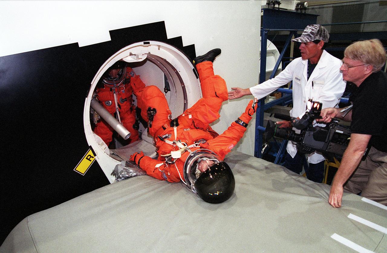
S99-05615 (19 May 1999) --- Astronaut Gerhard P.J. Thiele, mission specialist representing the European Space Agency (ESA), slides off the shuttle escape pole onto a soft surface during emergency bailout training for the STS-99 crew members. A second STS-99 crew member awaits his turn. Looking on are technician David Borjas (second right) and videographer Charles Clendaniel (right). The training took place at the crew compartment trainer (CCT) in the Systems Integration Facility at the Johnson Space Center (JSC).
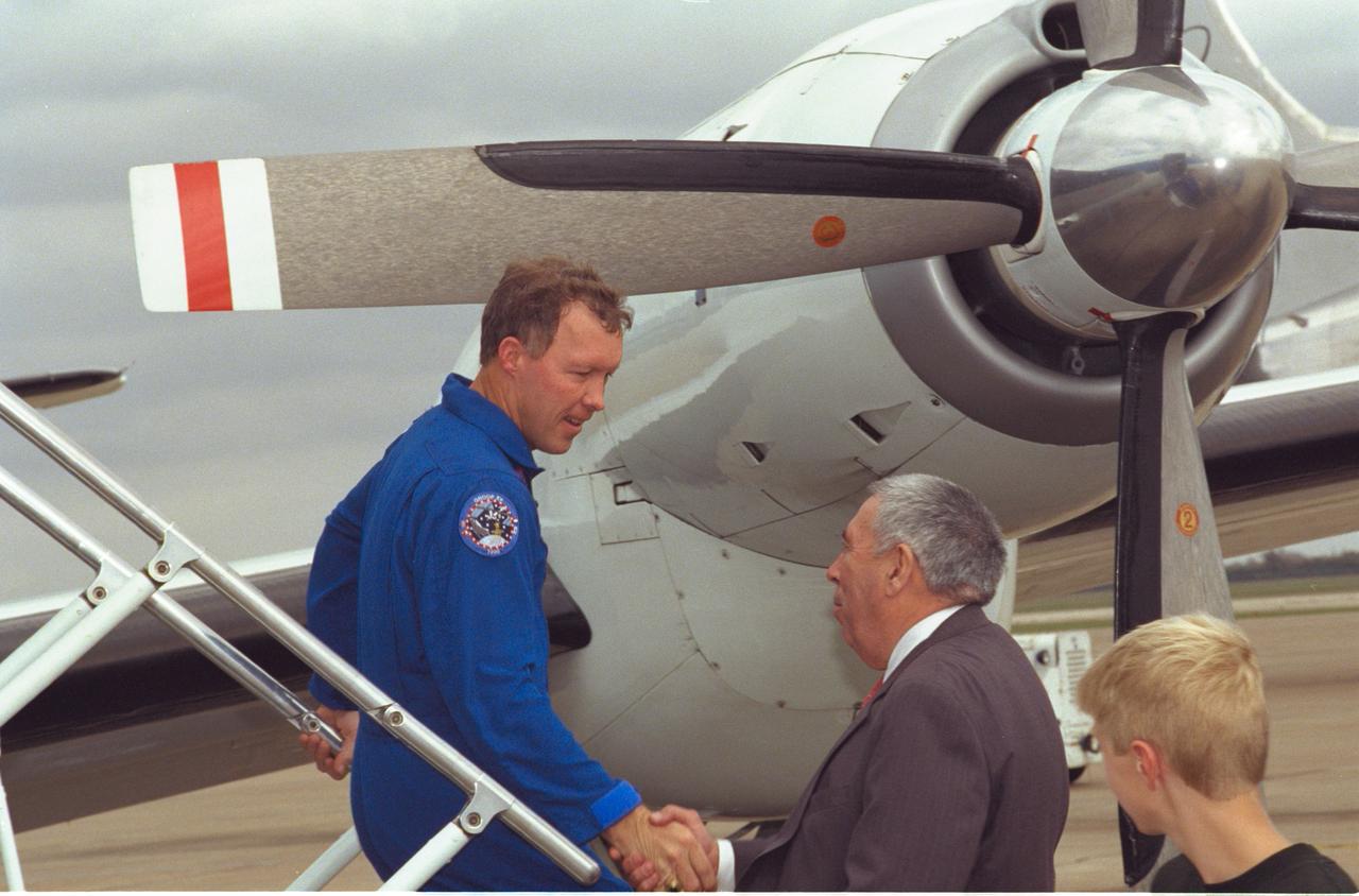
JSC2000-01643 (23 February 2000) --- JSC Director George W.S. Abbey greets astronaut Dominic L. Gorie, pilot, following the STS-99 crew's arrival at Ellington Field near the Johnson Space Center (JSC).
S99-05620 (19 May 1999) --- Astronaut Kevin R. Kregel (left), STS-99 mission commander, is briefed by a member of the crew training staff (out of frame at left) during emergency bailout training at the Johnson Space Center's Systems Integration Facility. Looking on is insertion technician George Britingham, United Space Alliance.
S99-05619 (19 May 1999) --- Astronauts Kevin R. Kregel (left) and Dominic L. Gorie, mission commander and pilot, respectively, for STS-99, are pictured during the briefing portion of emergency bailout training at the Johnson Space Center's Systems Integration Facility. Other members of the crew are out of frame at right.
S99-10569 (24 August 1999) --- Astronaut Janice Voss, STS-99 mission specialist, simulates a countdown during training at the Johnson Space Center's Systems Integration Facility. Voss is on the mid deck of a shuttle trainer to participate in a dress rehearsal for the pre-launch phase of her upcoming flight aboard the Space Shuttle Endeavour.
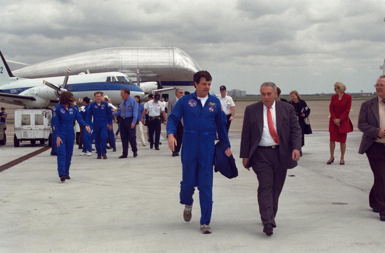
JSC2000-01671 (23 February 2000) --- Astronaut Kevin R. Kregel (left foreground), mission commander for STS-99, walks with JSC Director George W.S. Abbey toward Ellington Field's Hangar 990 following crew arrival on February 23. The six-member crew was welcomed by a crowd of supporters in the hangar.

S99-10566 (24 August 1999) --- Astronaut Janice Voss, STS-99 mission specialist, simulates a countdown during training at the Johnson Space Center's Systems Integration Facility. Voss is on the mid deck of a shuttle trainer to participate in a dress rehearsal for the pre-launch phase of her upcoming flight aboard the Space Shuttle Endeavour.
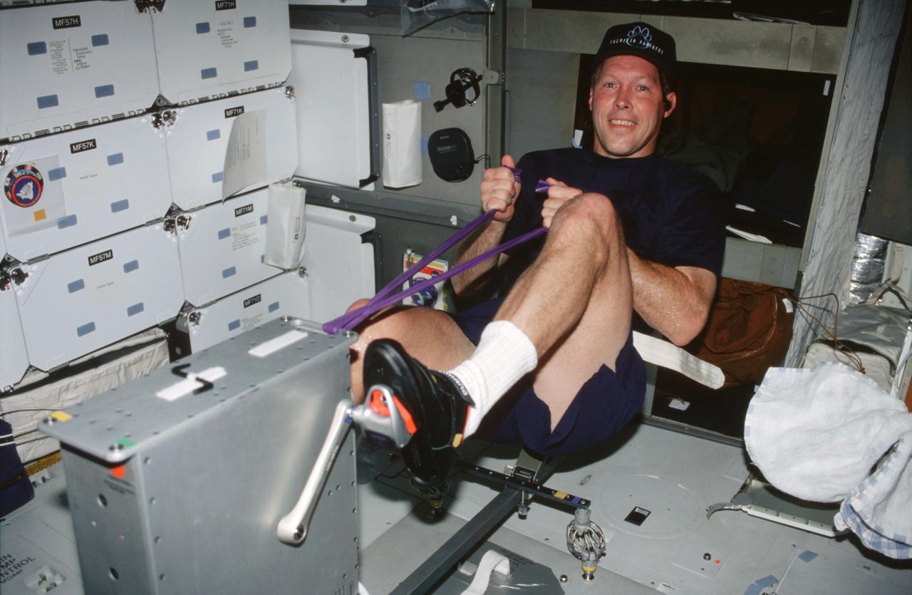
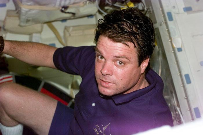
STS099-306-007 (11-22 February 2000) ---Astronaut Dominic L. Gorie, STS-99 pilot, works out on the ergometer device on the middeck of the Earth-orbiting Space Shuttle Endeavour.
S99-10565 (24 August 1999) --- Astronaut Mamoru Mohri, STS-99 mission specialist, goes over a checklist on the mid deck of a shuttle trainer at the Johnson Space Center (JSC). Mohri represents Japan's National Space Development Agency (NASDA). He will be making his second flight in space and his second flight aboard the Space Shuttle Endeavour, having flown as a payload specialist on the STS-47 mission in 1992.

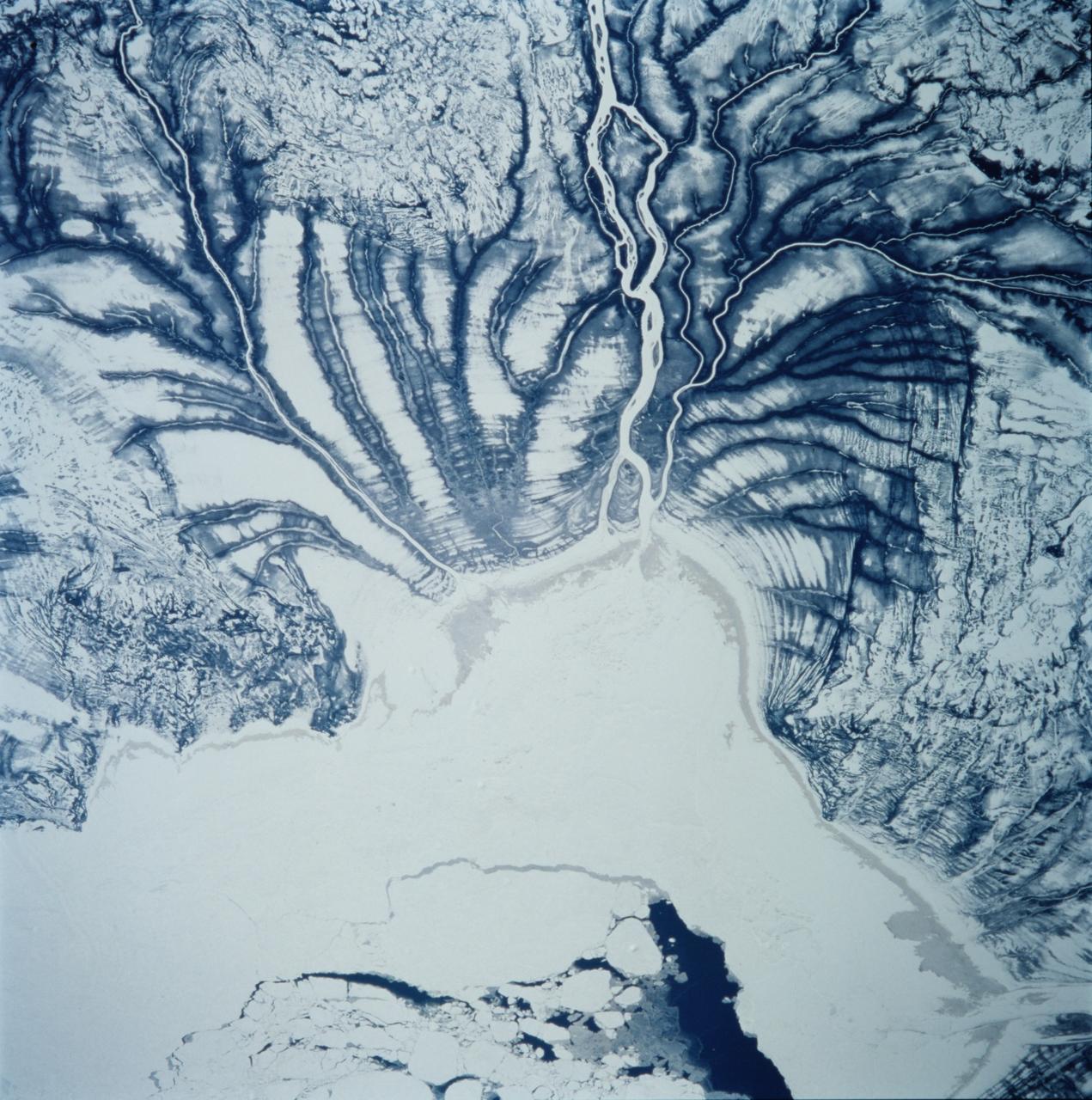
STS099-749-063 (11-22 February 2000) ---One of the astronauts aboard the Space Shuttle Endeavour for the STS-99 mission recorded this 70mm image of Manicouagan, one of the largest and most famous craters in Canada. Lake Manicouagan and Lake Mushalagan, frozen in this image, surround the central uplift of the crater. The original crater diameter was 100 kilometers and the age has been dated at 214 million years. Shattercones, striated features found in rocks deformed by the passage of shock waves, and shattered and brecciated rocks found in the central uplift confirm the crater's impact origin, according the NASA scientists studying the STS-99 photo collection.
S99-10573 (24 August 1999) --- Astronauts Mamoru Mohri (foreground) and Janice Voss participate in a simulation of pre-launch measures in one of the trainers at the Johnson Space Center's Systems Integration Facility. Mohri represents Japan's National Space Development Agency (NASDA). The four other STS-99 crew members were on the flight deck for this dress rehearsal.
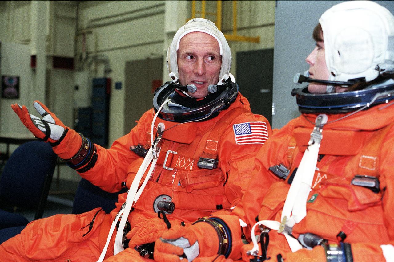
S99-05616 (19 May 1999) --- Astronauts Gerhard P.J. Thiele and Janet L. Kavandi await a briefing about emergency egress procedures during a training session at the Johnson Space Center's Systems Integration Facility. Thiele represents the European Space Agency (ESA). Other STS-99 crew members are out of frame at right.
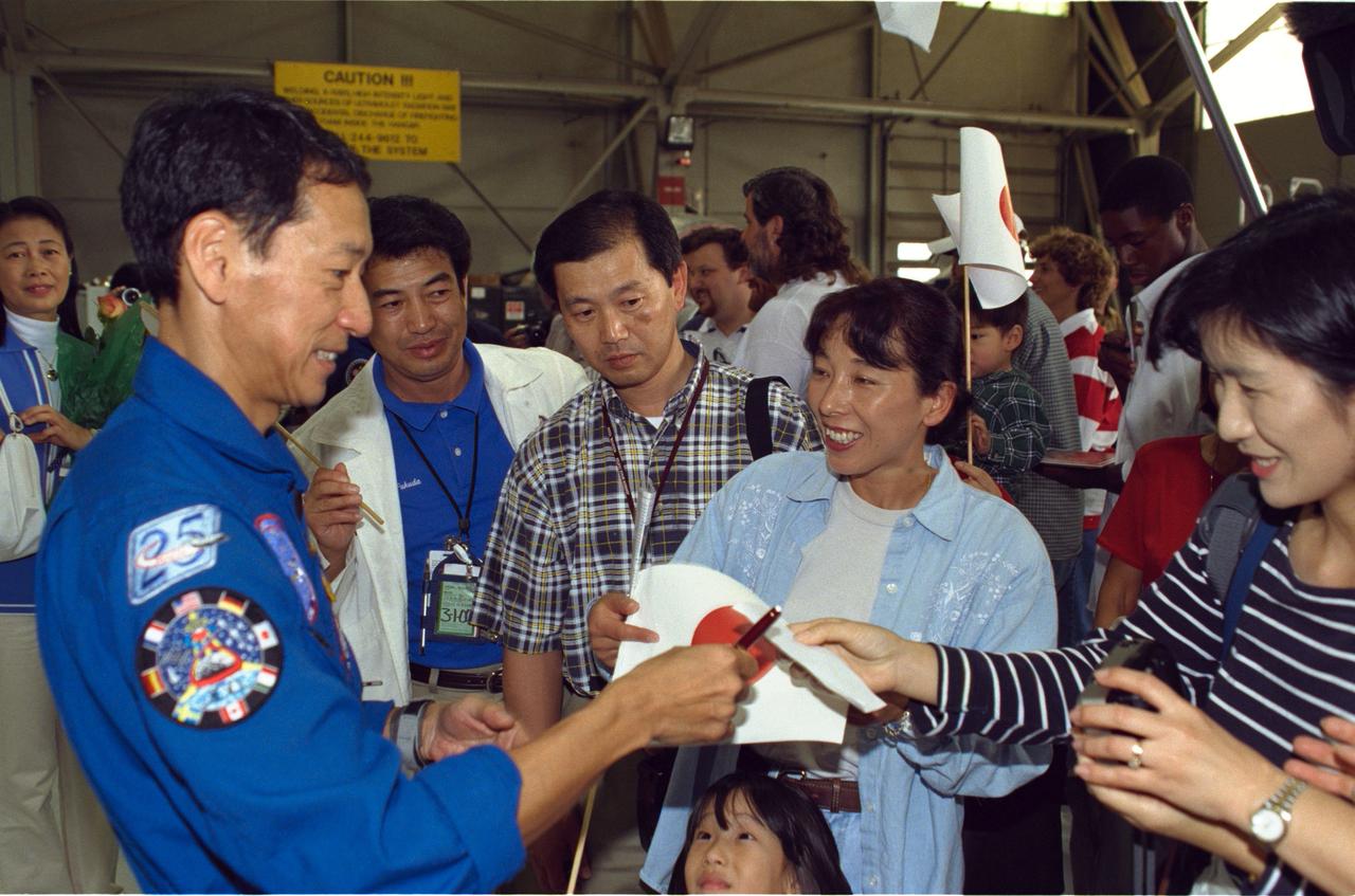
JSC2000-01638 (23 February 2000) --- Astronaut Mamoru Mohri signs autographs for some members of the crowd who turned out for the STS-99 crew arrival at Ellington Field, near the Johnson Space Center (JSC). After spending their first night back from space in Florida, the six astronauts flew to Houston, where they were greeted by the crowd of supporters at Ellington's Hangar 990.
JSC2000-01646 (23 February 2000) --- Three members of the STS-99 crew are greeted by JSC Director George W.S. Abbey following their arrival at Ellington Field, near the Johnson Space Center (JSC). From the left are astronauts Janet L. Kavandi, Janice Voss and Gerhard P.J. Thiele, all mission specialists. Thiele represents the European Space Agency (ESA).

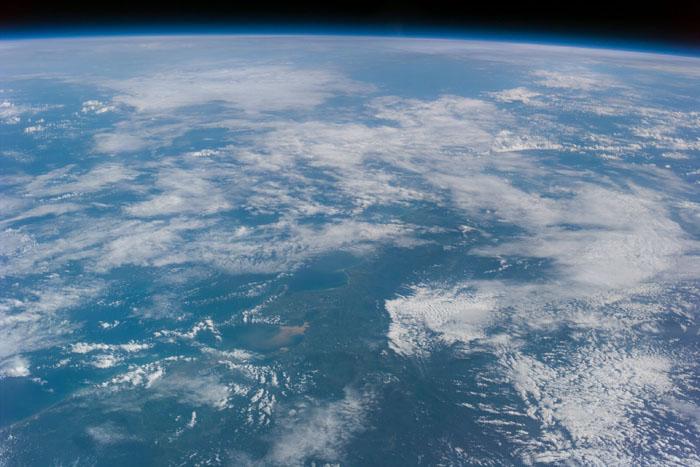
STS099-723-054 (11-22 February 2000) --- A wide-sweeping occlusion in the South Pacific Ocean caught the eye of one of the STS-99 crew members during the 11-day SRTM mission. The astronaut used a 70mm handheld camera to record the oblique scene.
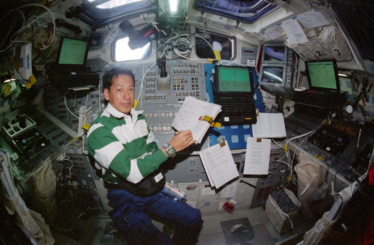
STS099-330-036 (11-22 February 2000) ---Astronaut Mamoru Mohri, mission specialist, on the aft flight deck of the Space Shuttle Endeavour, checks a data checklist for the STS-99 mission. Mohri represents Japan’s National Space Development Agency (NASDA).
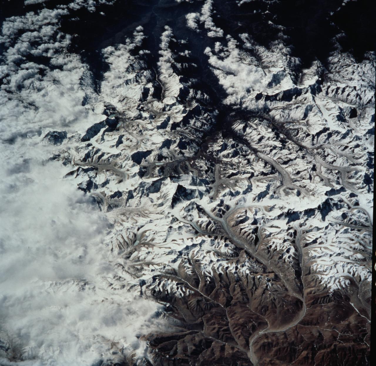
STS099-735-046 (11-22 February 2000) ---Mt. Everest (29,028 feet or 8,848 meters), is featured in the center of this 70mm frame photographed by one of the STS-99 crew members. Everest, also called Qomolangma Feng, is just north of the border between Nepal and China. The Himalayas and the Tibetan Plateau are products of the collision of the Indian and Eurasian tectonic plates. With the continuing northward march of India, the crust of the Earth has become thicker and the Tibetan Plateau has been uplifted to an average elevation of about 15,000 feet. According to NASA scientists studying the STS-99 imagery, fossil-bearing limestones are at the summit of the mountain. The scientists say that these limestones were deposited beneath the sea around 510 million years ago (Cambrian to Ordovician time). Glaciers, moraines, and outwash plains are spectacularly displayed. Glacial meltwaters in this area feed the Arun River, eventually reaching the Ganges on the plains of India.
STS099-330-019 (11-22 February 2000) ---Astronaut Dominic L. Gorie, STS-99 pilot, works with camera equipment on the middeck of the Earth-orbiting Space Shuttle Endeavour.
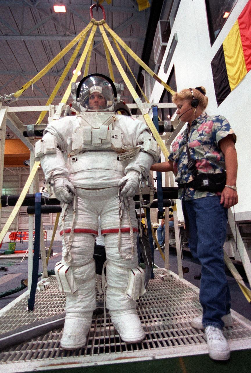
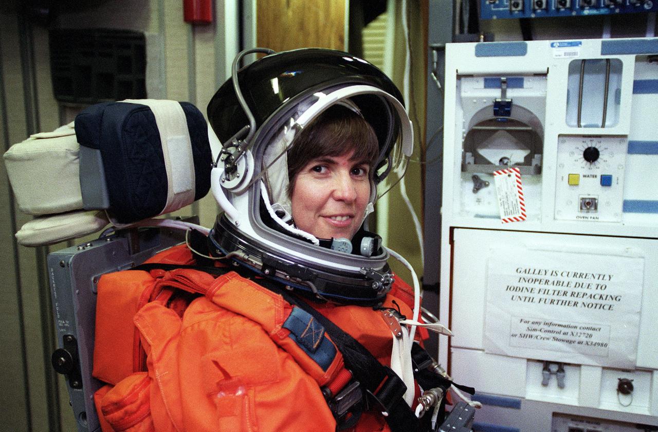
S99-05726 (26 May 1999) --- Astronaut Janet L. Kavandi, mission specialist, is about to be lowered into a deep pool for an underwater training session. The training took place at the Johnson Space Center's Neutral Buoyancy Laboratory (NBL), part of the Sonny Carter Training Center. Kavandi has weights on the training version of her extravehicular mobility unit (EMU) which help to provide neutral buoyancy in the pool. Astronauts Kavandi and Gerhard P.J. Thiele were participating in a rehearsal of a contingency space walk for the STS-99 mission.
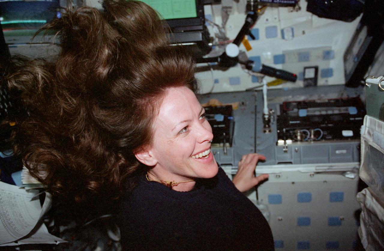
S99-E-5716 (18 February 2000) --- Astronaut Janet L. Kavandi on the mid deck of the Space Shuttle Endeavour. A series of electronic stills was taken of the STS-99 individual crew members on the day they got the good news from flight controllers in Houston that Shuttle Radar Topography Mission (SRTM) mapping time had been extended.

JSC2000-01065 (31 January 2000) --- Flight Director John Shannon, with his back to the FD console, waits patiently for the "go" or "no go" decision from the Kennedy Space Center (KSC). This attempt of the STS-99 Endeavour launch was eventually scrubbed, and managers quickly huddled to decide options for the next opportunity.
S99-09470 (11 August 1999) --- Three mission specialists participate in a STS-99 flight crew equipment (FCE) bench review. From the left (in the blue lab coats), astronauts Mamoru Mohri, Janice Voss and Janet L. Kavandi look over equipment and supplies for their assigned mission aboard the Space Shuttle Endeavour later this year. Mohri represents Japan's National Space Development Agency (NASDA). Such bench reviews are routine procedure for crews preparing for shuttle missions.

JSC2000-01071 (31 January 2000) --- Astronaut Joe F. Edwards, Jr., spacecraft communicator (CAPCOM), looks over notes at his console in Houston's Mission Control Center (MCC) while awaiting word regarding STS-99's launch status at Florida's Kennedy Space Center (KSC), several hundred miles away.
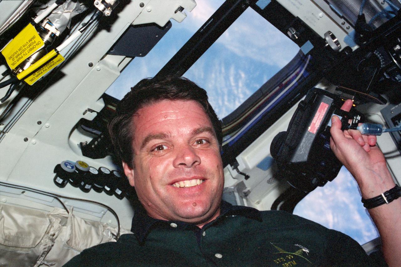
S99-E-5719 (18 February 2000) --- Astronaut Kevin R. Kregel, mission commander, on the mid deck of the Space Shuttle Endeavour. A series of electronic stills was taken of the STS-99 indiviaul crew members on the day they got the good news from flight controllers in Houston that Shuttle Radar Topograpy Mission (SRTM) mapping time had been extended.
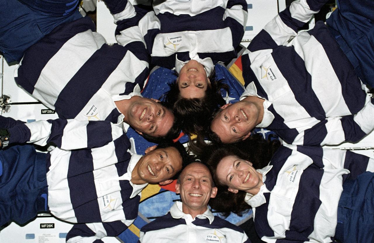
STS099-318-015 (11-22 February 2000) --- A "star-burst" pose by the STS-99 crew members helps to celebrate a successful Shuttle Radar Topographic Mission (SRTM) aboard NASA's Space Shuttle Endeavour. Astronaut Janice Voss is at top center. Clockwise, around the circle from her position, are astronauts Dominic L. Gorie, Janet L. Kavandi, Gerhard Thiele, Mamoru Mohri and Kevin R. Kregel. Mohri is with the Japanese Space Agency and Thiele represents the European Space Agency (ESA).
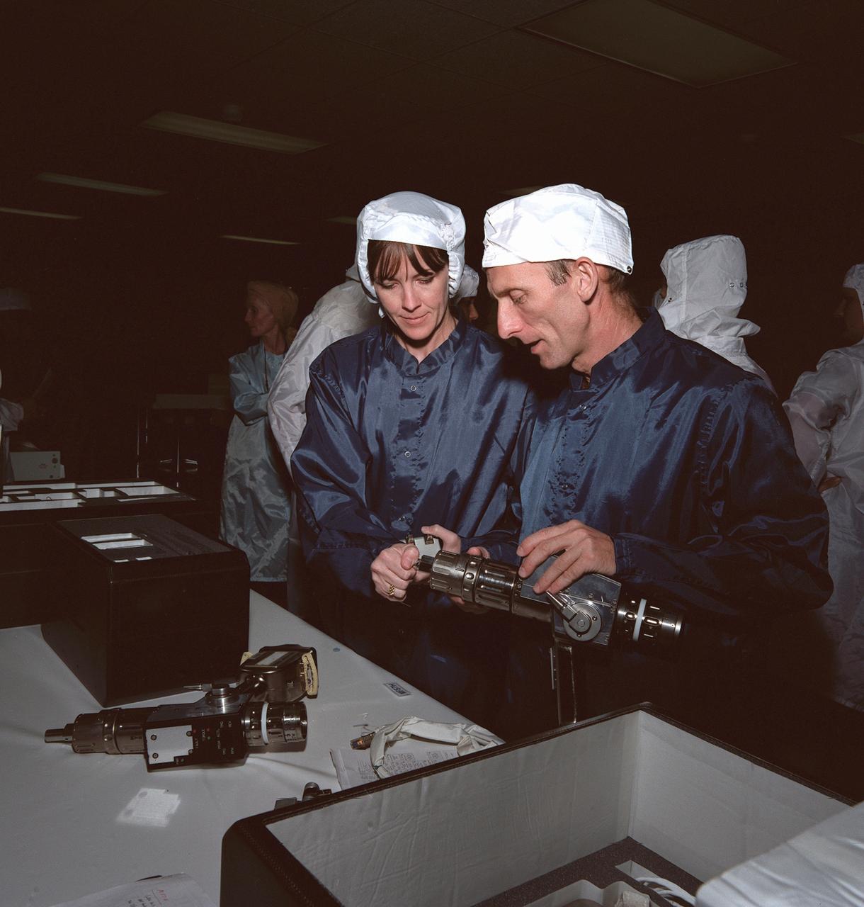
S99-09460 (11 August 1999) --- Astronauts Janet L. Kavandi and Gerhard P.J. Thiele, mission specialists, participate in a flight crew equipment (FCE) bench review of STS-99 hardware. The two are preparing for a mission aboard the Space Shuttle Endeavour later this year. Thiele, who represents the European Space Agency (ESA), is one of two international mission specialists on the crew.
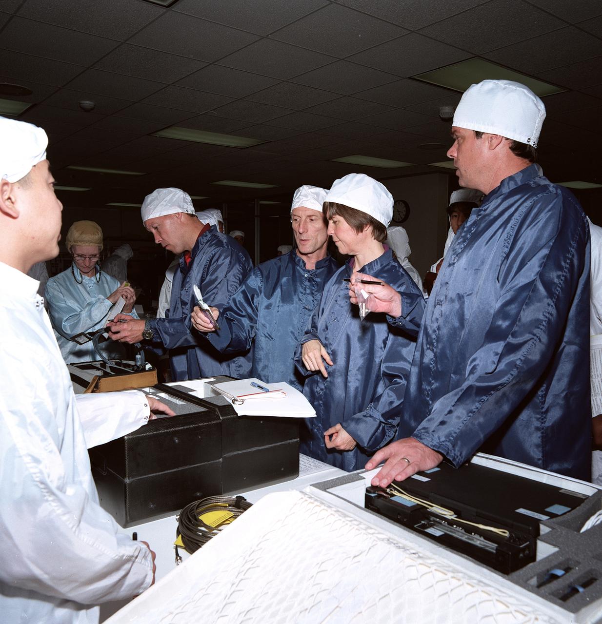
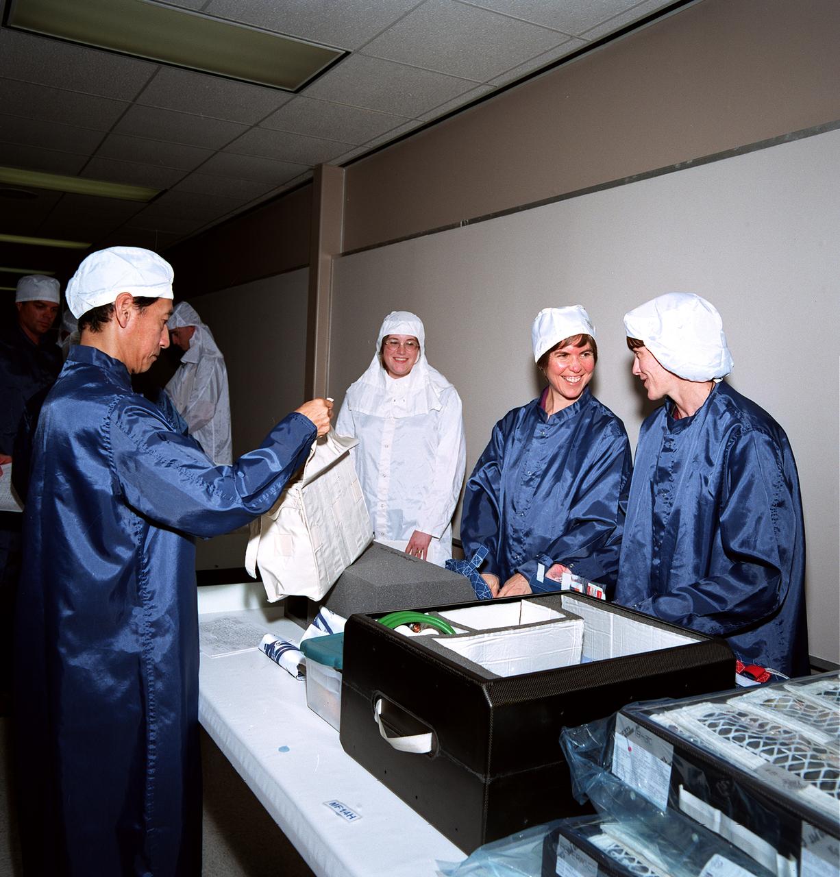
S99-09457 (11 August 1999) --- Wearing clean room suits, members of the STS-99 crew inspect some of the gear they will be using on their upcoming space mission. From the left (in blue lab coats) are astronauts Dominic L. Gorie, pilot; Gerhard P.J. Thiele, mission specialist representing the European Space Agency (ESA); Janice Voss, mission specialist; and Kevin R. Kregel, mission commander. This type flight crew equipment (FCE) bench review is routine preflight procedure for all shuttle crews.
STS099-734-012 (11-22 February 2000) ---As photographed by one of the STS-99 crew members aboard the Space Shuttle Endeavour, a shallow atmosphere displays the various layers by color. The layer that holds the gases we breathe are under the yellow band called the tropopause.
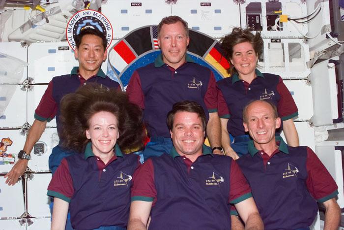
S99-E-5731 (18 February 2000) --- Not often seen together on the STS-99 flight which provides around-the-clock coverage for the Shuttle Radar Topography Mission (SRTM), the six astronauts pose for one of the traditional inflight crew portraits on Endeavour's mid deck. In the rear are the Blue Team members (from left), Mamoru Mohri, Dominic L. Gorie and Janice Voss. In front are Red Team members Janet L. Kavandi, Kevin R. Kregel and Gerhard P.J. Thiele. Mohri is with Japan's National Space Development Agency (NASDA) and Thiele represents the European Space Agency (ESA).
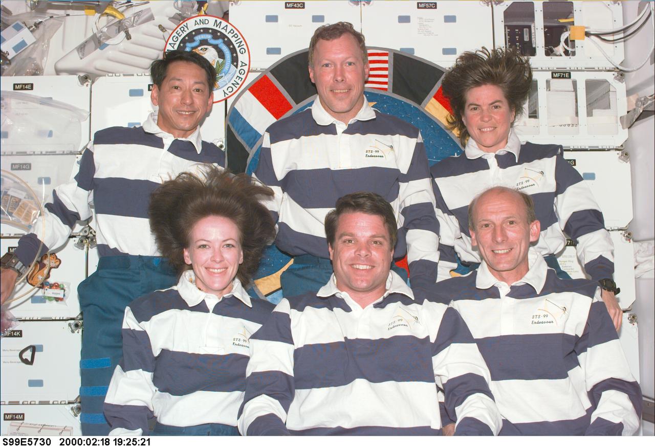
S99-E-5730 (18 February 2000) --- Not often seen together on the STS-99 flight which provides around-the-clock coverage for the Shuttle Radar Topography Mission (SRTM), the six astronauts pose for the traditional inflight crew portrait on Endeavour's mid deck. In the rear are the Blue Team members (from left), Mamoru Mohri, Dominic L. Gorie and Janice Voss. In front are Red Team members Janet L. Kavandi, Kevin R. Kregel and Gerhard P.J. Thiele. Mohri is with Japan's National Space Development Agency (NASDA) and Thiele represents the European Space Agency (ESA).

STS099-729-086 (11-22 February 2000) ---In this 70mm frame photographed by one of the STS-99 crew members, the city of Miami encroaches the eastern edge of the Everglades in Florida. The Everglades is an International Biosphere Reserve World Heritage Site. This subtropical wilderness encompasses a relatively flat (does not exceed 2.4 meters above sea level) saw-grass marsh region of 10,000 square kilometers (4,000 square miles). The only source of water in the Everglades is from rainfall. The flow of water is detectable in this image, slowly moving from Lake Okeechobee to Florida Bay; the light blue, shallow area (less than 3 meters) between the mainland and the Keys; and the southwestern Florida coast.
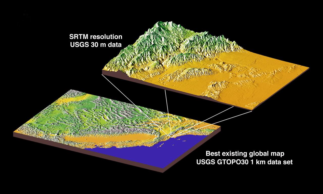
JSC2000E01552 (January 2000) --- This chart compares currently available global map data with the data which will be provided by SRTM during STS-99. The area depicted is the California coast. The SRTM mission will have approximately 1,000 scheduled data takes (every time Endeavour is over land). Data acquisition will be conducted in excess of 80 hours. The recording rate for data will be 180 Mbits/sec for C-band, 90 Mbits/sec for X-band. Total raw radar data will be approximately 9.8 terabytes (15,000 CDs). The mission will utilize some 300 high-density tapes (each tape records 30 min. of C-band, or 60 min. of X-band data).
S99-09469 (11 August 1999) --- Wearing clean room suits, all six members of the STS-99 crew inspect some of the gear they will be using on their upcoming space shuttle mission. From the left (in blue lab coats) are astronauts Mamoru Mohri, mission specialist representing Japan's National Development Space Agency (NASDA); Dominic L. Gorie (partially obscured), pilot; Kevin R. Kregel, mission commander; Janice Voss, mission specialist; Janet L. Kavandi, mission specialist; and Gerhard P.J. Thiele, mission specialist representing the European Space Agency (ESA). This type flight crew equipment (FCE) bench review is routine preflight procedure for all shuttle crews.
STS099-714-060 (11-22 February 2000) ---One of the STS-99 astronauts aboard the Space Shuttle Endeavour recorded this 70mm image of Cairo, one of the fastest growing cities in the world. The city is moving outside the dark-colored Nile valley into the surrounding desert. New developments are side by side with ancient monuments. The pyramids at Giza are highlighted by their shadows and the new development in the desert to the South is outlined by lighter-colored roads. Further south of the Giza pyramids on the west side of the Nile River are the Step and Bent Pyramids, respectively.

STS099-722-077 (11-22 February 2000) ---Both topography and bathymetry combine with wind and sea currents to produce a pattern of sea ice in the extreme southern Sea of Okhotsk, in this scene photographed by one of the STS-99 crew members aboard the Space Shuttle Endeavour. The rugged shoreline of north Hokkaido and the Kurile Archipelago have channeled northerly winds and surface waters into a gyre here, clearly depicted in the pattern of sea ice.
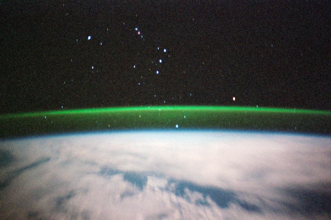
STS099-356-026 (11-22 February 2000) ---Because of its time exposure, this STS-99 35mm frame provides a view of several stars. The thin greenish band above the horizon is airglow; radiation emitted by the atmosphere from a layer about 30 kilometers thick and about 100 kilometers altitude. The predominant emission in airglow is the green 5577-Angstrom wavelength emission from atomic oxygen atoms. Airglow is always and everywhere present in the atmosphere; it results from the recombination of molecules that have been broken apart by solar radiation during the day. But airglow is so faint that it can only be seen at night by looking "edge on" at the emission layer, such as the view astronauts have in orbit.
STS099-329-019 (11-22 February 2000) --- Astronaut Janet L. Kavandi, mission specialist, appears joyous over the success of the Shuttle Radar Topography Mission (SRTM) and other experiments on the flight deck of the Space Shuttle Endeavour. The Red Team member is standing beneath an electronic still camera (ESC) mounted in Endeavour's overhead windows. The camera stayed busy throughout the ll-day mission taking vertical imagery of Earth points of opportunity for the EarthKAM project. Students across the United States and in France, Germany and Japan took photos throughout the STS-99 mission. And they are using these new photos, plus all the images already available in the EarthKAM system, to enhance their classroom learning in Earth and space science, social studies, geography, mathematics and more.
STS099-706-090 (11-22 February 2000) ---One of the astronauts aboard the Space Shuttle Endeavour for the STS-99 mission recorded this 70mm image of Hannah Bay, in the southern part of St. James Bay. The river is the Harricanaw River. Numerous shorelines around Hudson and St. James Bays are distinctive in winter because of snow cover. According to NASA scientists, shorelines were created when the overlying glaciers retreated and the land underneath rebounded causing the Hudson and St. James Bay waters to retreat northward. These ridges are 100 to 200 meters in width and heights can reach up to 7 meters. The land along St. James Bay consists mainly of tidal flats and salt marshes.
STS099-314-035 (11-22 February 2000) ---Astronaut Kevin R. Kregel, mission commander, works with camera equipment, which was used for the EarthKAM project. The camera stayed busy throughout the 11-day mission taking vertical imagery of the Earth points of opportunity for the project. Students across the United States and in France, Germany and Japan took photos throughout the STS-99 mission. And they are using these new photos, plus all the images already available in the EarthKAM system, to enhance their classroom learning in Earth and space science, social studies, geography, mathematics and more.
S99-E-5705 (18 February 2000) --- Astronauts Mamoru Mohri (left), mission specialist, and Dominic L. Gorie, pilot, on the flight deck of the Space Shuttle Endeavour. Mohri, representing Japan's National Space Development Agency (NASDA), and Gorie serve on the Blue Team for the scheduled 11-day mission along with astronaut Janice Voss (out of frame). A series of electronic stills was taken of the STS-99 crew members on the day they got the good news from flight controllers in Houston that Shuttle Radar Topograpy Mission (SRTM) mapping time had been extended.
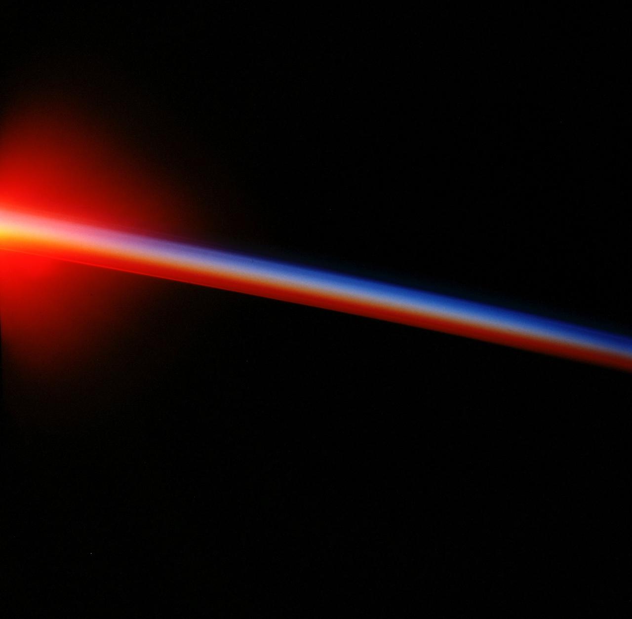
S99-E-5555 (17 February 2000) --- As photographed from the Space Shuttle Endeavour, this oblique electronic still image of Earth's horizon reveals a great deal of cloud cover. In the case of the electronic still camera (ESC), as well as film-bearing instruments, clouds naturally obscure views of recognizable land masses. Much of Earth is heavily cloud covered during the current mission and meteorlogists and oceanographers are interested in studying that aspect. However, the Shuttle Radar Topography Mission's other sensing equipment, X-SAR and C-band antennae, are able to penetrate cloud cover and record important topographic data for mapmakers and scientists of other disciplines. In addition to the sensing equipment mentioned above, this mission is supporting the EarthKAM project which utilizes the services of another electronic still camera mounted in Endeavour's windows. Unlike this oblique view, EarthKAM records strictly vertical or nadir imagery of points all over the world. Students across the United States and in France, Germany and Japan are taking photos throughout the STS-99 mission. And they are using these new photos, plus all the images already available in the EarthKAM system, to enhance their classroom learning in Earth and space science, social studies, geography, mathematics and more.
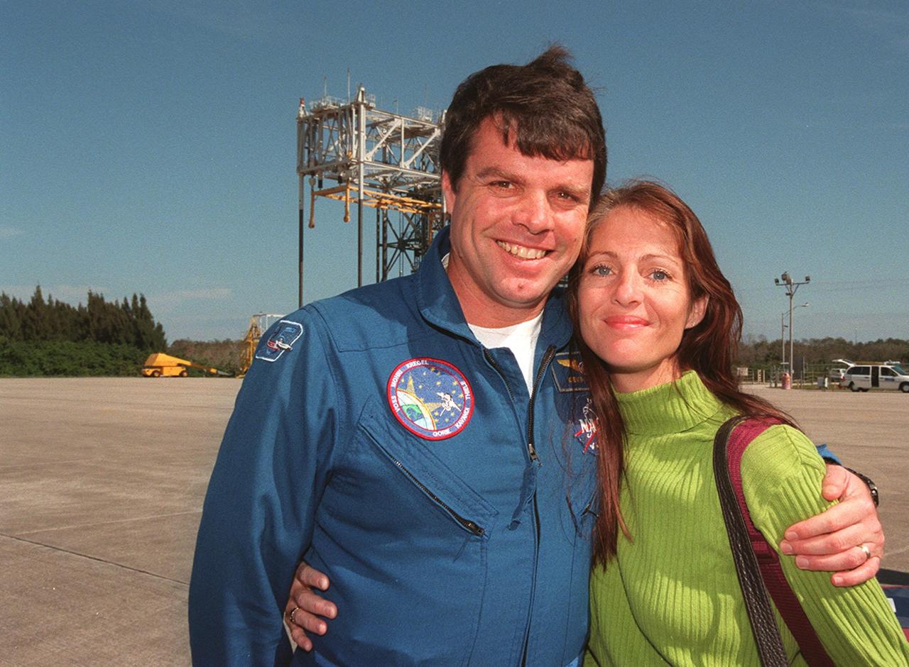
At the Shuttle Landing Facility, STS-99 Commander Kevin Kregel is joined by his wife, Jeanne, before their departure for Houston. The STS-99 crew completed a successful 11-day Shuttle Radar Topography Mission mapping 47 million square miles of the Earth's surface before landing at KSC Feb. 22

At the Shuttle Landing Facility, STS-99 Commander Kevin Kregel is joined by his wife, Jeanne, before their departure for Houston. The STS-99 crew completed a successful 11-day Shuttle Radar Topography Mission mapping 47 million square miles of the Earth's surface before landing at KSC Feb. 22

STS099-727-045 (11-22 February 2000) ---One of the astronauts aboard the Space Shuttle Endeavour for the STS-99 mission recorded this 70mm image of Long Island, New York. The entire length of Long Island is visible in partial sunglint from Lower Bay to Block Island Sound. According to geologists, the origin and shape of Long Island are due to continental collision and glaciers that once dominated the landscape. A collision between North America and Africa about 300 million years ago caused the Appalachian Mountains to rise, they say. Streams carried sediment from the eroding Appalachians and also carved a valley that would one day become Long Island Sound. The scientists went on to say that retreating ice sheets 22,000 years ago allowed the land to rebound with the highest points becoming Long Island.

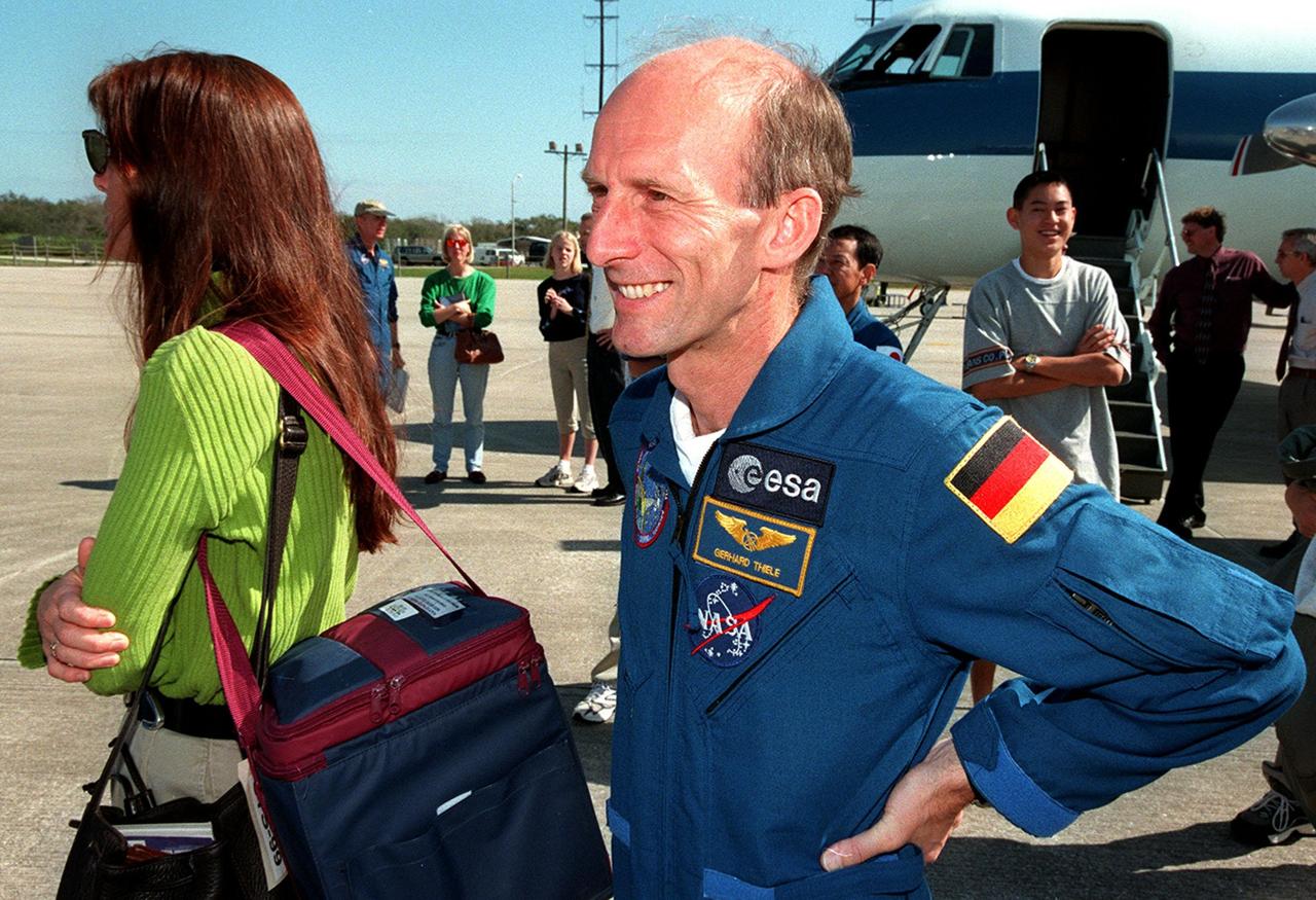
At the Shuttle Landing Facility, STS-99 Mission Specialist Gerhard Thiele (left) joins Mission Specialist Janet Kavandi with her daughter before their departure for Houston. The STS-99 crew completed a successful 11-day Shuttle Radar Topography Mission mapping 47 million square miles of the Earth's surface before landing at KSC Feb. 22
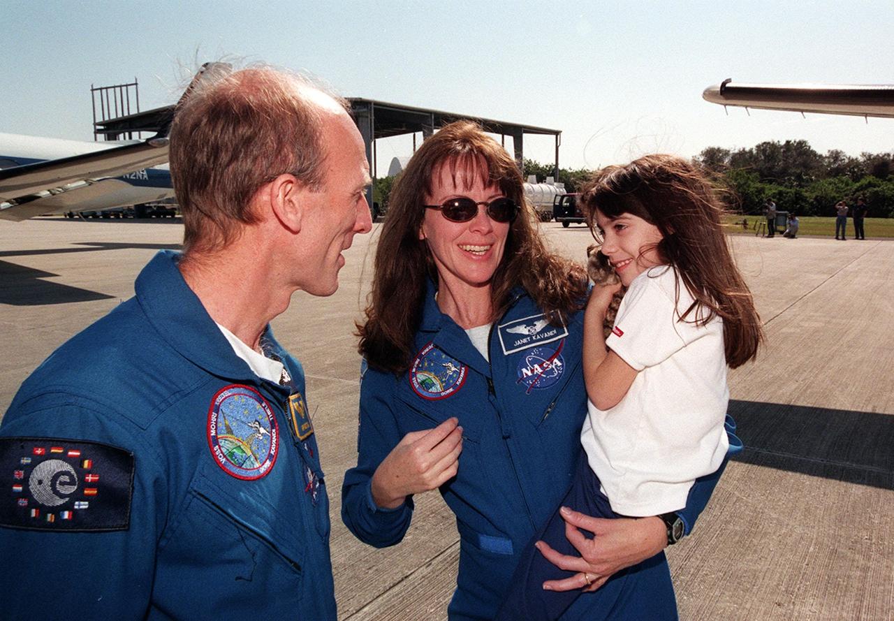
At the Shuttle Landing Facility, STS-99 Mission Specialist Gerhard Thiele (left) joins Mission Specialist Janet Kavandi with her daughter before their departure for Houston. The STS-99 crew completed a successful 11-day Shuttle Radar Topography Mission mapping 47 million square miles of the Earth's surface before landing at KSC Feb. 22
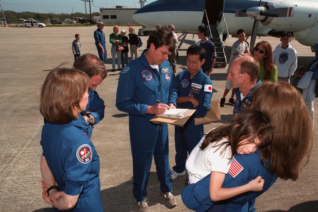
The STS-99 crew get ready to leave KSC with their families for a return trip to Houston. From left are Mission Specialist Janice Voss, Pilot Dominic Gorie, Commander Kevin Kregel, and Mission Specialists Mamoru Mohri of Japan, Gerhard Thiele of Germany, and Janet Kavandi, holding her daughter. The STS-99 crew completed a successful 11-day Shuttle Radar Topography Mission mapping 47 million square miles of the Earth's surface before landing at KSC Feb. 22

STS-99 Mission Specialist Mamoru Mohri (left) is joined by his son and wife, Akiko, at the Shuttle Landing Facility before their departure for Houston. The STS-99 crew completed a successful 11-day Shuttle Radar Topography Mission mapping 47 million square miles of the Earth's surface before landing at KSC Feb. 22

At the Shuttle Landing Facility, STS-99 crew members join family members for their return trip to Houston. At left is Jeanne Kregel, wife of Commander Kevin Kregel. At right is Mission Specialist Gerhard Thiele of Germany. The STS-99 crew completed a successful 11-day Shuttle Radar Topography Mission mapping 47 million square miles of the Earth's surface before landing at KSC Feb. 22
At the Shuttle Landing Facility, STS-99 crew members join family members for their return trip to Houston. At left is Jeanne Kregel, wife of Commander Kevin Kregel. At right is Mission Specialist Gerhard Thiele of Germany. The STS-99 crew completed a successful 11-day Shuttle Radar Topography Mission mapping 47 million square miles of the Earth's surface before landing at KSC Feb. 22
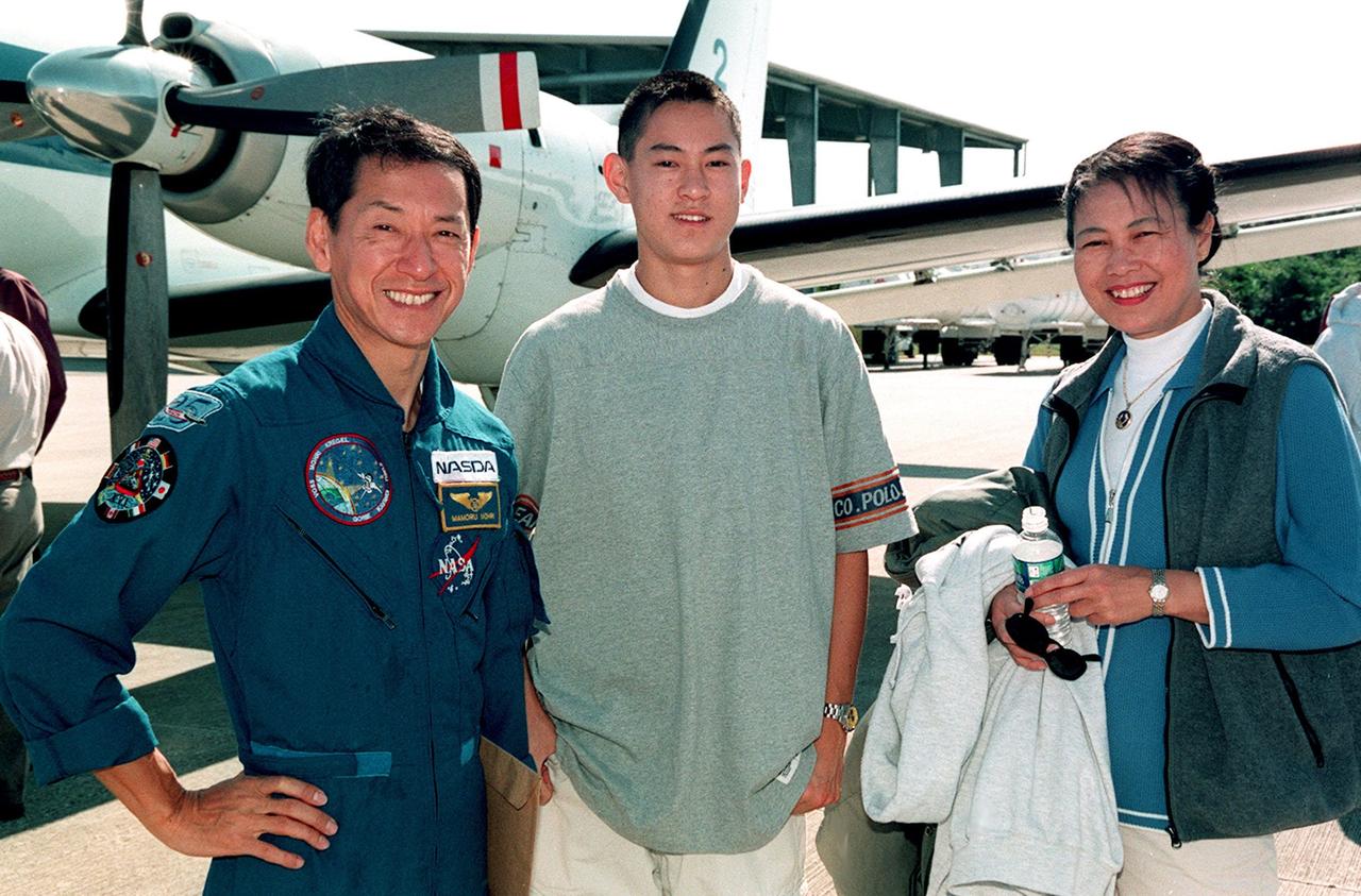
STS-99 Mission Specialist Mamoru Mohri (left) is joined by his son and wife, Akiko, at the Shuttle Landing Facility before their departure for Houston. The STS-99 crew completed a successful 11-day Shuttle Radar Topography Mission mapping 47 million square miles of the Earth's surface before landing at KSC Feb. 22

The STS-99 crew get ready to leave KSC with their families for a return trip to Houston. From left are Mission Specialist Janice Voss, Pilot Dominic Gorie, Commander Kevin Kregel, and Mission Specialists Mamoru Mohri of Japan, Gerhard Thiele of Germany, and Janet Kavandi, holding her daughter. The STS-99 crew completed a successful 11-day Shuttle Radar Topography Mission mapping 47 million square miles of the Earth's surface before landing at KSC Feb. 22
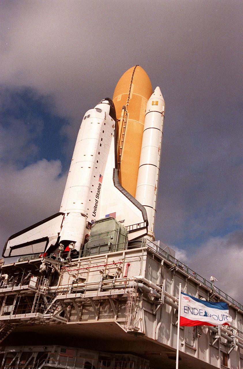
KENNEDY SPACE CENTER, Fla. -- Space Shuttle Endeavour is viewed atop the mobile launcher platform on its way to Launch Pad 39A for launch of mission STS-99. Named the Shuttle Radar Topography Mission (SRTM), STS-99 involves an international project spearheaded by the National Imagery and Mapping Agency and NASA, with participation of the German Aerospace Center DLR. SRTM will chart a new course, using two antennae and a 200-foot-long section of space station-derived mast protruding from its payload bay, to produce unrivaled 3-D images of the Earth's surface. The result of the Shuttle Radar Topography Mission could be close to 1 trillion measurements of the Earth's topography. Besides contributing to the production of better maps, these measurements could lead to improved water drainage modeling, more realistic flight simulators, better locations for cell phone towers, and enhanced navigation safety. STS-99 is scheduled for launch in January 2000
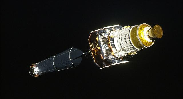
99-E-10028 (23 July 1999) --- The Chandra X-Ray observatory and its upper stage were captured during separation from the Space Shuttle Columbia with the STS-93 HDTV Camcorder inside the crew cabin.
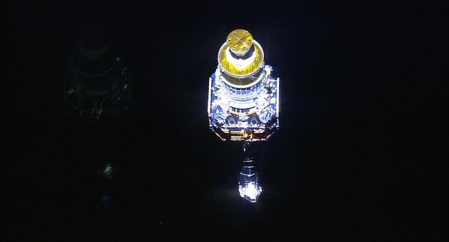
99-E-10027 (23 July 1999) --- The Chandra X-Ray observatory and its upper stage were captured during separation from the Space Shuttle Columbia with the STS-93 HDTV Camcorder inside the crew cabin.
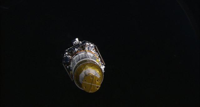
99-E-10026 (23 July 1999) --- The Chandra X-Ray observatory and its upper stage were captured during separation from the Space Shuttle Columbia with the STS-93 HDTV Camcorder inside the crew cabin.
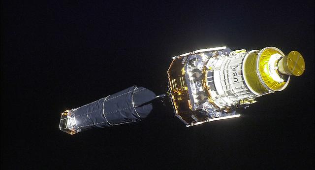
99-E-10020 (23 July 1999) --- The Chandra X-Ray observatory and its upper stage were captured during separation from the Space Shuttle Columbia with the STS-93 HDTV Camcorder inside the crew cabin.

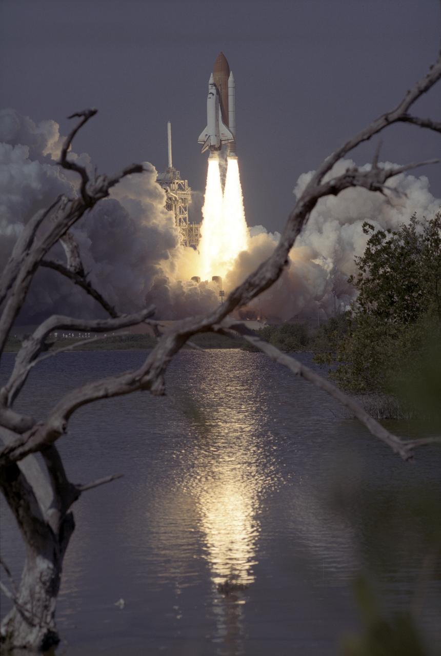
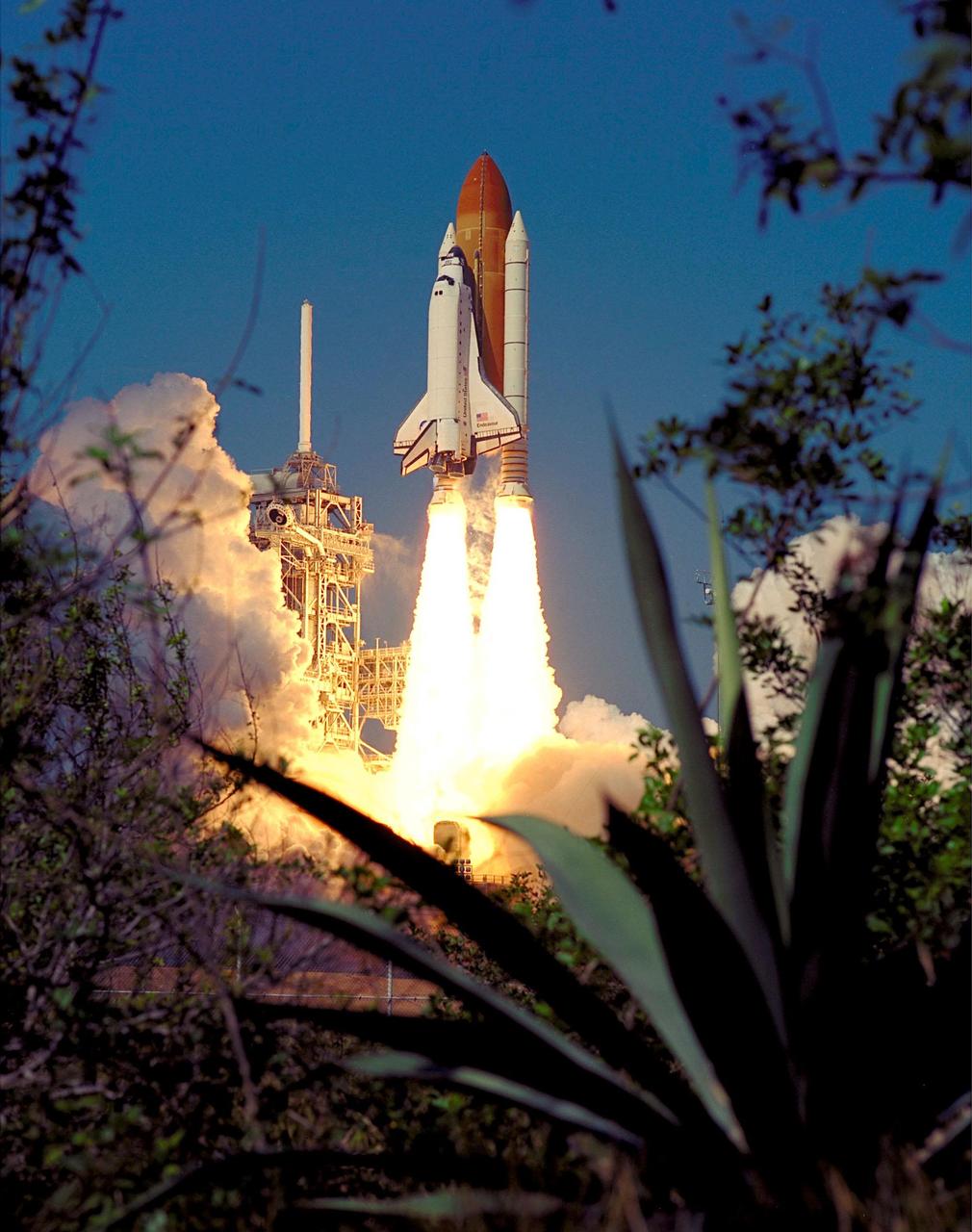
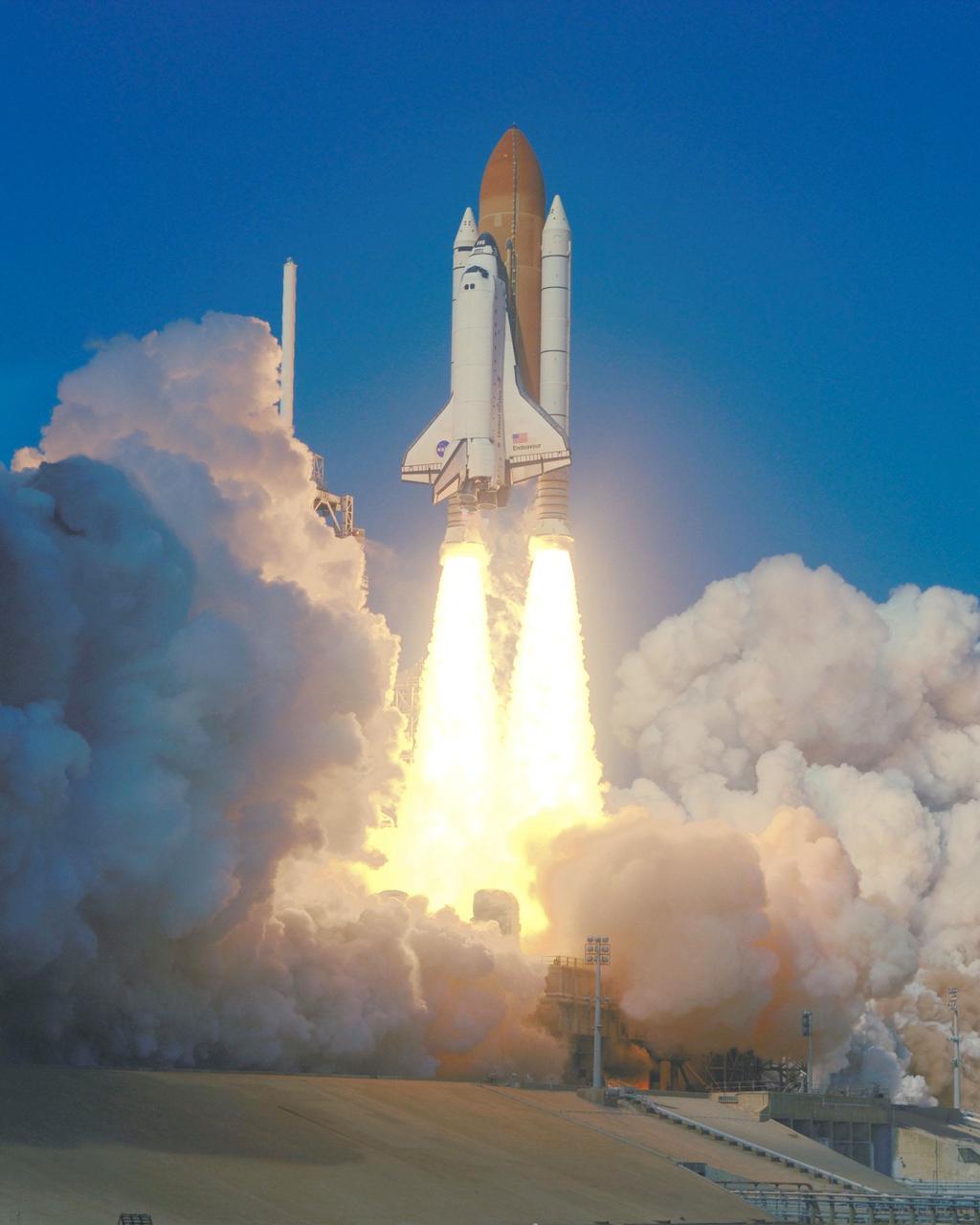
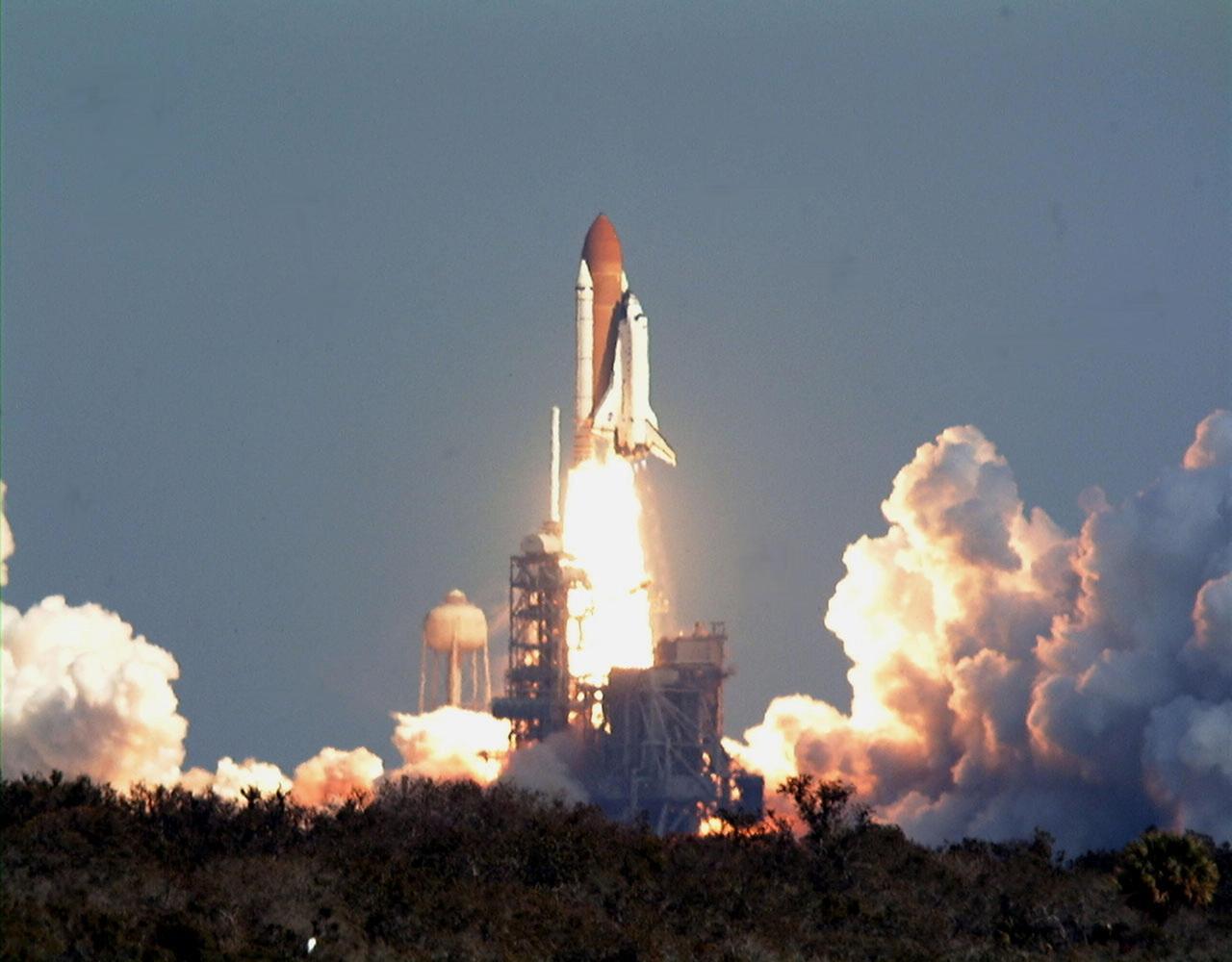
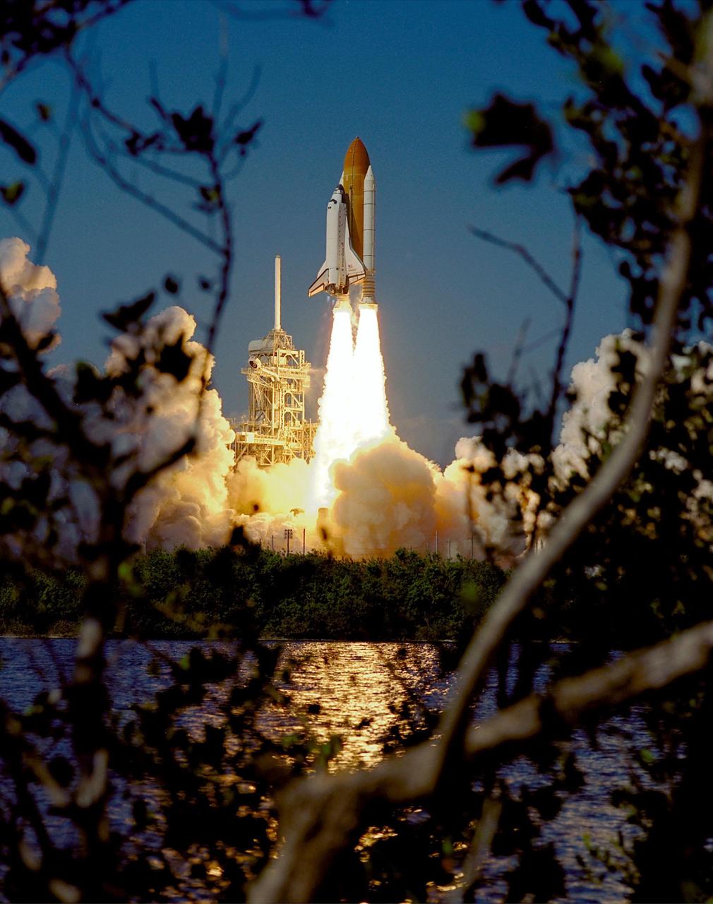
KENNEDY SPACE CENTER, Fla. -- After liftoff at 12:43:40 p.m. EST, the Space Shuttle Endeavour on mission STS-99 soars into a clear blue sky, trailed by flames and rolling billows of steam. The brilliant flames are reflected in the nearby waters. Known as the Shuttle Radar Topography Mission (SRTM), STS-99 will chart a new course to produce unrivaled 3-D images of the Earth's surface. The result of the SRTM could be close to 1 trillion measurements of the Earth's topography. The mission is expected to last 11days, with Endeavour landing at KSC Tuesday, Feb. 22, at 4:36 p.m. EST. This is the 97th Shuttle flight and 14th for Shuttle Endeavour
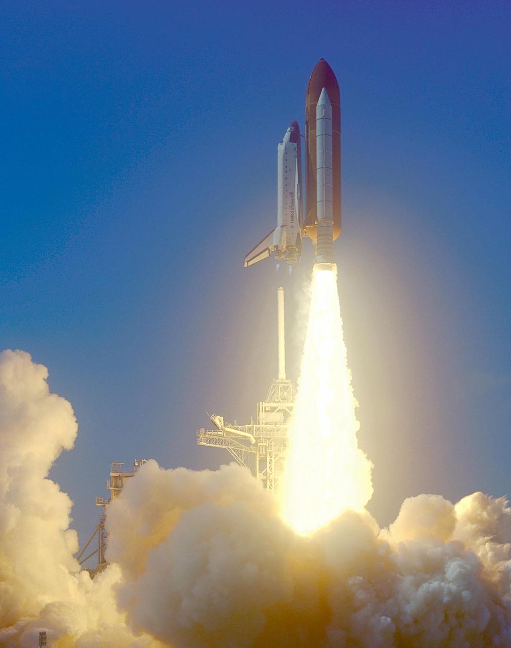
KENNEDY SPACE CENTER, Fla. -- A rainbow corona of light shimmers behind Space Shuttle Endeavour as a column of flame hurls it into space. Liftoff of the Shuttle on mission STS-99 occurred at 12:43:40 p.m. EST. Known as the Shuttle Radar Topography Mission (SRTM), STS-99 will chart a new course to produce unrivaled 3-D images of the Earth's surface. The result of the SRTM could be close to 1 trillion measurements of the Earth's topography. The mission is expected to last 11days, with Endeavour landing at KSC Tuesday, Feb. 22, at 4:36 p.m. EST. This is the 97th Shuttle flight and 14th for Shuttle Endeavour

In the Operations and Checkout Building, STS-99 Pilot Dominic Gorie has his helmet checked by Santos Medina, with United Space Alliance, during final launch preparations. Known as the Shuttle Radar Topography Mission (SRTM), STS-99 is scheduled for liftoff at 12:30 p.m. EST from Launch Pad 39A. The SRTM will chart a new course to produce unrivaled 3-D images of the Earth's surface. The result of the Shuttle Radar Topography Mission could be close to 1 trillion measurements of the Earth's topography. The mission is expected to last 11days, with Endeavour landing at KSC Tuesday, Feb. 22, at 4:36 p.m. EST. This is the 97th Shuttle flight and 14th for Shuttle Endeavour
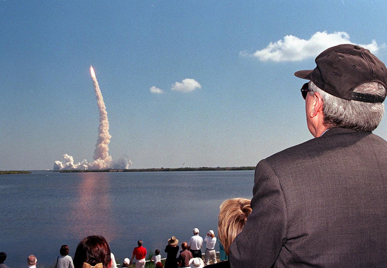
KENNEDY SPACE CENTER, FLA. -- NASA Administrator Dan Goldin (right) joins other spectators at the Banana Creek viewing site in cheering the successful launch of Space Shuttle Endeavour on mission STS-99. The perfect liftoff occurred at 12:43:40 p.m. EST. Known as the Shuttle Radar Topography Mission (SRTM), STS-99 will chart a new course to produce unrivaled 3-D images of the Earth's surface. The result of the SRTM could be close to 1 trillion measurements of the Earth's topography. The mission is expected to last 11days, with Endeavour landing at KSC Tuesday, Feb. 22, at 4:36 p.m. EST. This is the 97th Shuttle flight and 14th for Shuttle Endeavour
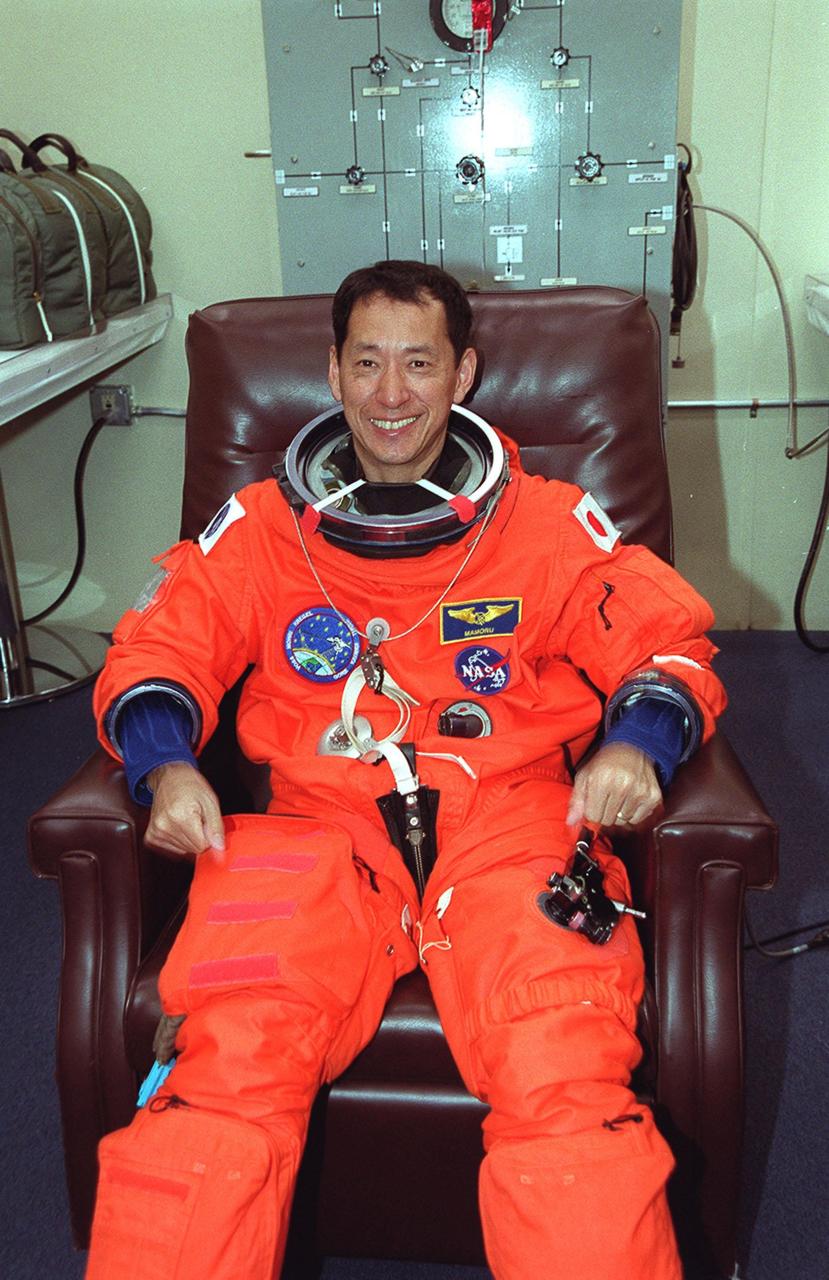
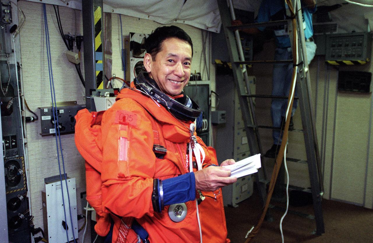
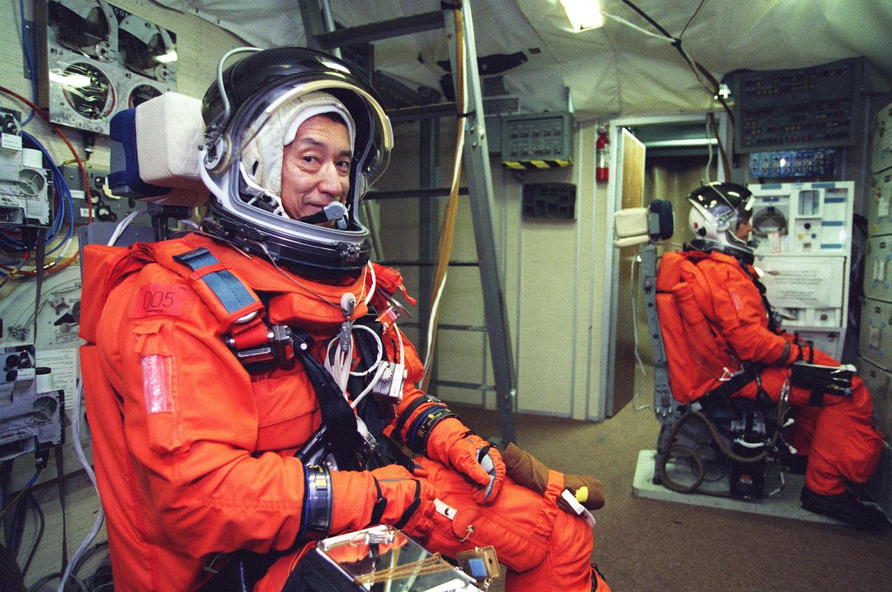
In the Operations and Checkout Building, STS-99 Mission Specialist Mamoru Mohri of Japan smiles as he dons his launch and entry suit during final launch preparations. Known as the Shuttle Radar Topography Mission (SRTM), STS-99 is scheduled for liftoff at 12:30 p.m. EST from Launch Pad 39A. The SRTM will chart a new course to produce unrivaled 3-D images of the Earth's surface. The result of the Shuttle Radar Topography Mission could be close to 1 trillion measurements of the Earth's topography. The mission is expected to last 11days, with Endeavour landing at KSC Tuesday, Feb. 22, at 4:36 p.m. EST. This is the 97th Shuttle flight and 14th for Shuttle Endeavour

In the Operations and Checkout Building, STS-99 Mission Specialist Mamoru Mohri of Japan smiles as he dons his launch and entry suit during final launch preparations. Known as the Shuttle Radar Topography Mission (SRTM), STS-99 is scheduled for liftoff at 12:30 p.m. EST from Launch Pad 39A. The SRTM will chart a new course to produce unrivaled 3-D images of the Earth's surface. The result of the Shuttle Radar Topography Mission could be close to 1 trillion measurements of the Earth's topography. The mission is expected to last 11days, with Endeavour landing at KSC Tuesday, Feb. 22, at 4:36 p.m. EST. This is the 97th Shuttle flight and 14th for Shuttle Endeavour

KENNEDY SPACE CENTER, Fla. -- Through the shrubs surrounding the water near Launch Pad 39A can be seen Space Shuttle Endeavour roaring into the clear blue Florida sky on mission STS-99. aunch of Endeavour occurred at 12:43:40 p.m. EST. Known as the Shuttle Radar Topography Mission (SRTM), STS-99 will chart a new course to produce unrivaled 3-D images of the Earth's surface. The result of the SRTM could be close to 1 trillion measurements of the Earth's topography. The mission is expected to last 11days, with Endeavour landing at KSC Tuesday, Feb. 22, at 4:36 p.m. EST. This is the 97th Shuttle flight and 14th for Shuttle Endeavour
KENNEDY SPACE CENTER, Fla. -- Space Shuttle Endeavour seems to leap from the among the palmettos on its launch into the clear blue Florida sky. Launch of Endeavour on mission STS-99 occurred at 12:43:40 p.m. EST. Known as the Shuttle Radar Topography Mission (SRTM), STS-99 will chart a new course to produce unrivaled 3-D images of the Earth's surface. The result of the SRTM could be close to 1 trillion measurements of the Earth's topography. The mission is expected to last 11days, with Endeavour landing at KSC Tuesday, Feb. 22, at 4:36 p.m. EST. This is the 97th Shuttle flight and 14th for Shuttle Endeavour

KENNEDY SPACE CENTER, FLA. -- NASA Administrator Dan Goldin (right) joins other spectators at the Banana Creek viewing site in cheering the successful launch of Space Shuttle Endeavour on mission STS-99. The perfect liftoff occurred at 12:43:40 p.m. EST. Known as the Shuttle Radar Topography Mission (SRTM), STS-99 will chart a new course to produce unrivaled 3-D images of the Earth's surface. The result of the SRTM could be close to 1 trillion measurements of the Earth's topography. The mission is expected to last 11days, with Endeavour landing at KSC Tuesday, Feb. 22, at 4:36 p.m. EST. This is the 97th Shuttle flight and 14th for Shuttle Endeavour
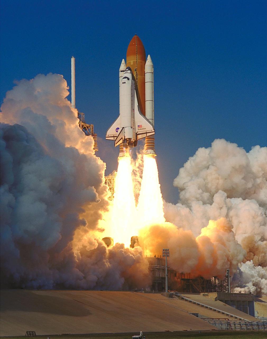
KENNEDY SPACE CENTER, Fla. -- Twin columns of flame flow from the solid rocket boosters, lighting the billows of steam behind them with an orange glow, as Space Shuttle Endeavour roars into space on mission STS-99. Liftoff occurred at 12:43:40 p.m. EST. Known as the Shuttle Radar Topography Mission (SRTM), STS-99 will chart a new course to produce unrivaled 3-D images of the Earth's surface. The result of the SRTM could be close to 1 trillion measurements of the Earth's topography. The mission is expected to last 11days, with Endeavour landing at KSC Tuesday, Feb. 22, at 4:36 p.m. EST. This is the 97th Shuttle flight and 14th for Shuttle Endeavour
KENNEDY SPACE CENTER, FLA. -- Workers in the Vehicle Assembly Building move orbiter Endeavour's replacement main engine No. 3 onto a work stand to prepare it for installation in the orbiter. Following routine testing procedures on a separate test engine, analysis revealed delamination on the wall of the engine's main combustion chamber. When data revealed that one of Endeavour's engines had undergone similar testing procedures, managers opted to replace the suspect engine as a precaution. Space Shuttle Endeavour is targeted for launch on mission STS-99 on Jan. 13, 2000, at 1:11 p.m. EST. STS-99 is the Shuttle Radar Topography Mission

KENNEDY SPACE CENTER, Fla. -- Twin columns of flame flow from the solid rocket boosters, lighting the billows of steam behind them with an orange glow, as Space Shuttle Endeavour roars into space on mission STS-99. Liftoff occurred at 12:43:40 p.m. EST. Known as the Shuttle Radar Topography Mission (SRTM), STS-99 will chart a new course to produce unrivaled 3-D images of the Earth's surface. The result of the SRTM could be close to 1 trillion measurements of the Earth's topography. The mission is expected to last 11days, with Endeavour landing at KSC Tuesday, Feb. 22, at 4:36 p.m. EST. This is the 97th Shuttle flight and 14th for Shuttle Endeavour
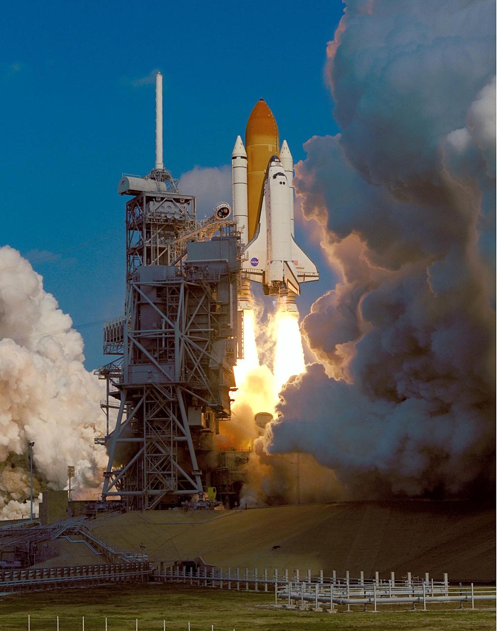
KENNEDY SPACE CENTER, Fla. -- Clouds of steam and smoke nearly surround Space Shuttle Endeavour as it rises past the launch tower on Launch Pad 39A. Liftoff of the Shuttle on mission STS-99 occurred at 12:43:40 p.m. EST. Known as the Shuttle Radar Topography Mission (SRTM), STS-99 will chart a new course to produce unrivaled 3-D images of the Earth's surface. The result of the SRTM could be close to 1 trillion measurements of the Earth's topography. The mission is expected to last 11days, with Endeavour landing at KSC Tuesday, Feb. 22, at 4:36 p.m. EST. This is the 97th Shuttle flight and 14th for Shuttle Endeavour
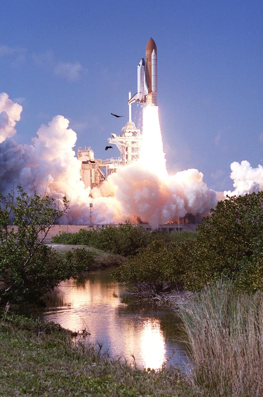
KENNEDY SPACE CENTER, Fla. -- After liftoff at 12:43:40 p.m. EST, the Space Shuttle Endeavour on mission STS-99 soars into a clear blue sky, trailed by flames and rolling billows of steam. The brilliant flames are reflected in the nearby waters. Known as the Shuttle Radar Topography Mission (SRTM), STS-99 will chart a new course to produce unrivaled 3-D images of the Earth's surface. The result of the SRTM could be close to 1 trillion measurements of the Earth's topography. The mission is expected to last 11days, with Endeavour landing at KSC Tuesday, Feb. 22, at 4:36 p.m. EST. This is the 97th Shuttle flight and 14th for Shuttle Endeavour
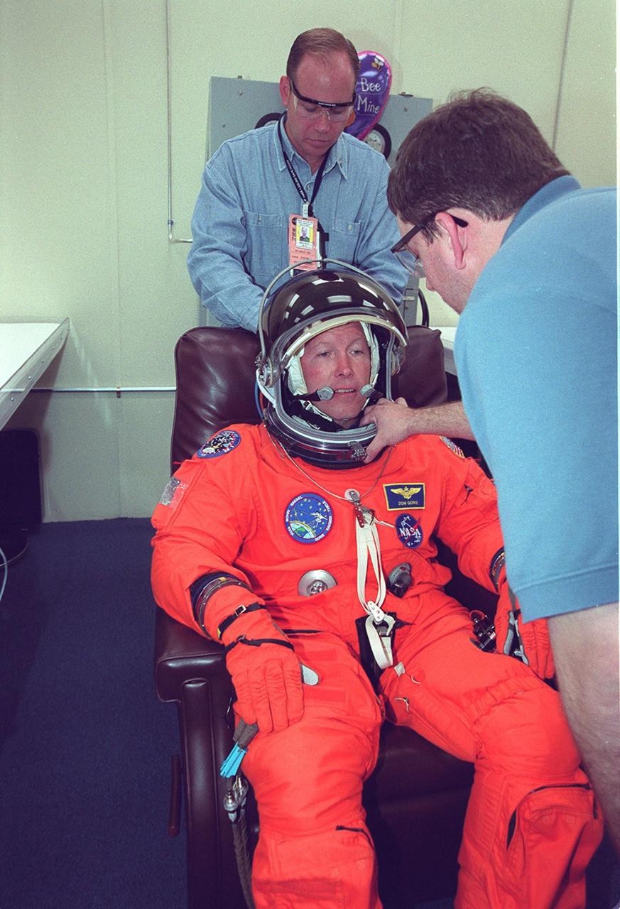
In the Operations and Checkout Building, STS-99 Pilot Dominic Gorie has his helmet checked by Santos Medina, with United Space Alliance, during final launch preparations. Known as the Shuttle Radar Topography Mission (SRTM), STS-99 is scheduled for liftoff at 12:30 p.m. EST from Launch Pad 39A. The SRTM will chart a new course to produce unrivaled 3-D images of the Earth's surface. The result of the Shuttle Radar Topography Mission could be close to 1 trillion measurements of the Earth's topography. The mission is expected to last 11days, with Endeavour landing at KSC Tuesday, Feb. 22, at 4:36 p.m. EST. This is the 97th Shuttle flight and 14th for Shuttle Endeavour
KENNEDY SPACE CENTER, Fla. -- Twin columns of flame flow from the solid rocket boosters, lighting the billows of steam behind them with an orange glow, as Space Shuttle Endeavour roars into space on mission STS-99. Liftoff occurred at 12:43:40 p.m. EST. Known as the Shuttle Radar Topography Mission (SRTM), STS-99 will chart a new course to produce unrivaled 3-D images of the Earth's surface. The result of the SRTM could be close to 1 trillion measurements of the Earth's topography. The mission is expected to last 11days, with Endeavour landing at KSC Tuesday, Feb. 22, at 4:36 p.m. EST. This is the 97th Shuttle flight and 14th for Shuttle Endeavour
KENNEDY SPACE CENTER, Fla. -- A perfect launch on a perfect Florida day! Framed by two immense billows of steam, Space Shuttle Endeavour breaks its Earthly tethers to soar into a clear blue sky. Liftoff of mission STS-99 occurred at 12:43:40 p.m. EST. Known as the Shuttle Radar Topography Mission (SRTM), STS-99 will chart a new course to produce unrivaled 3-D images of the Earth's surface. The result of the SRTM could be close to 1 trillion measurements of the Earth's topography. The mission is expected to last 11days, with Endeavour landing at KSC Tuesday, Feb. 22, at 4:36 p.m. EST. This is the 97th Shuttle flight and 14th for Shuttle Endeavour
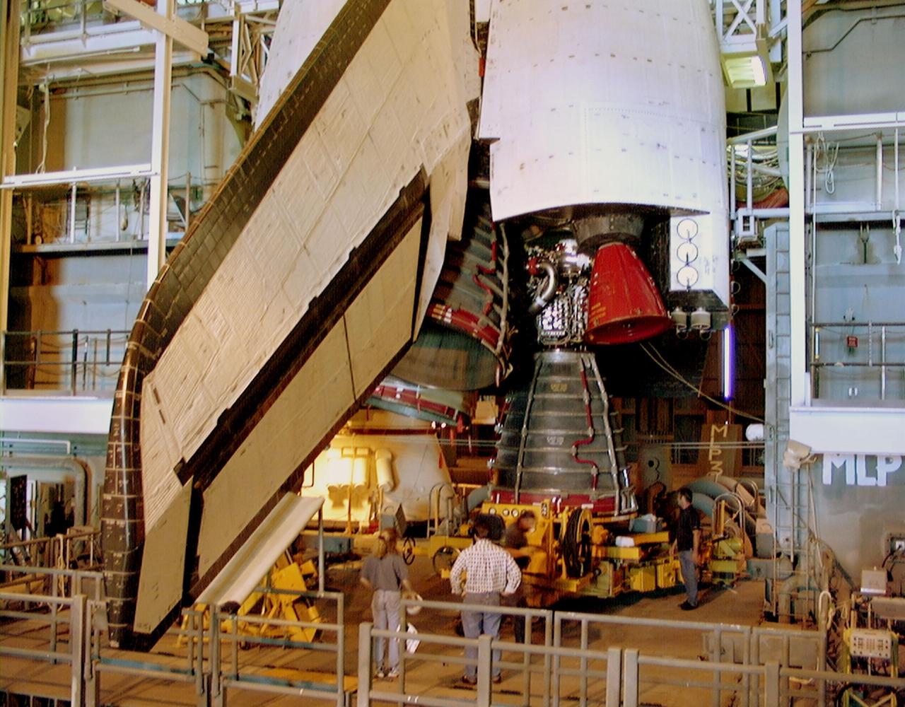
KENNEDY SPACE CENTER, FLA. -- Endeavour's replacement main engine No. 3 is moved underneath the orbiter for installation. Following routine testing procedures on a separate test engine, analysis revealed delamination on the wall of the engine's main combustion chamber. When data revealed that one of Endeavour's engines had undergone similar testing procedures, managers opted to replace the suspect engine as a precaution. Space Shuttle Endeavour is targeted for launch at 1:11 p.m. EST Jan. 13, 2000, on mission STS-99. It will be Endeavour's 14th flight. STS-99 is the Shuttle Radar Topography Mission

KENNEDY SPACE CENTER, Fla. -- Trailing a column of flame and smoke that dwarfs it, Space Shuttle Endeavour leaps into the clear blue Florida sky on mission STS-99. Liftoff occurred at 12:43:40 p.m. EST. Known as the Shuttle Radar Topography Mission (SRTM), STS-99 will chart a new course to produce unrivaled 3-D images of the Earth's surface. The result of the SRTM could be close to 1 trillion measurements of the Earth's topography. The mission is expected to last 11days, with Endeavour landing at KSC Tuesday, Feb. 22, at 4:36 p.m. EST. This is the 97th Shuttle flight and 14th for Shuttle Endeavour
KENNEDY SPACE CENTER, FLA. -- Workers in the Vehicle Assembly Building move orbiter Endeavour's main engine No. 3 (in front) out of the way before moving the replacement engine into place. Following routine testing procedures on a separate test engine, analysis revealed delamination on the wall of the engine's main combustion chamber. When data revealed that one of Endeavour's engines had undergone similar testing procedures, managers opted to replace the suspect engine as a precaution. Space Shuttle Endeavour is targeted for launch on mission STS-99 on Jan. 13, 2000, at 1:11 p.m. EST. STS-99 is the Shuttle Radar Topography Mission

KENNEDY SPACE CENTER, Fla. -- A perfect launch on a perfect Florida day! Framed by two immense billows of steam, Space Shuttle Endeavour breaks its Earthly tethers to soar into a clear blue sky. Liftoff of mission STS-99 occurred at 12:43:40 p.m. EST. Known as the Shuttle Radar Topography Mission (SRTM), STS-99 will chart a new course to produce unrivaled 3-D images of the Earth's surface. The result of the SRTM could be close to 1 trillion measurements of the Earth's topography. The mission is expected to last 11days, with Endeavour landing at KSC Tuesday, Feb. 22, at 4:36 p.m. EST. This is the 97th Shuttle flight and 14th for Shuttle Endeavour

KENNEDY SPACE CENTER, Fla. -- Space Shuttle Endeavour seems to leap from the among the palmettos on its launch into the clear blue Florida sky. Launch of Endeavour on mission STS-99 occurred at 12:43:40 p.m. EST. Known as the Shuttle Radar Topography Mission (SRTM), STS-99 will chart a new course to produce unrivaled 3-D images of the Earth's surface. The result of the SRTM could be close to 1 trillion measurements of the Earth's topography. The mission is expected to last 11days, with Endeavour landing at KSC Tuesday, Feb. 22, at 4:36 p.m. EST. This is the 97th Shuttle flight and 14th for Shuttle Endeavour

KENNEDY SPACE CENTER, Fla. -- A rainbow corona of light shimmers behind Space Shuttle Endeavour as a column of flame hurls it into space. Liftoff of the Shuttle on mission STS-99 occurred at 12:43:40 p.m. EST. Known as the Shuttle Radar Topography Mission (SRTM), STS-99 will chart a new course to produce unrivaled 3-D images of the Earth's surface. The result of the SRTM could be close to 1 trillion measurements of the Earth's topography. The mission is expected to last 11days, with Endeavour landing at KSC Tuesday, Feb. 22, at 4:36 p.m. EST. This is the 97th Shuttle flight and 14th for Shuttle Endeavour
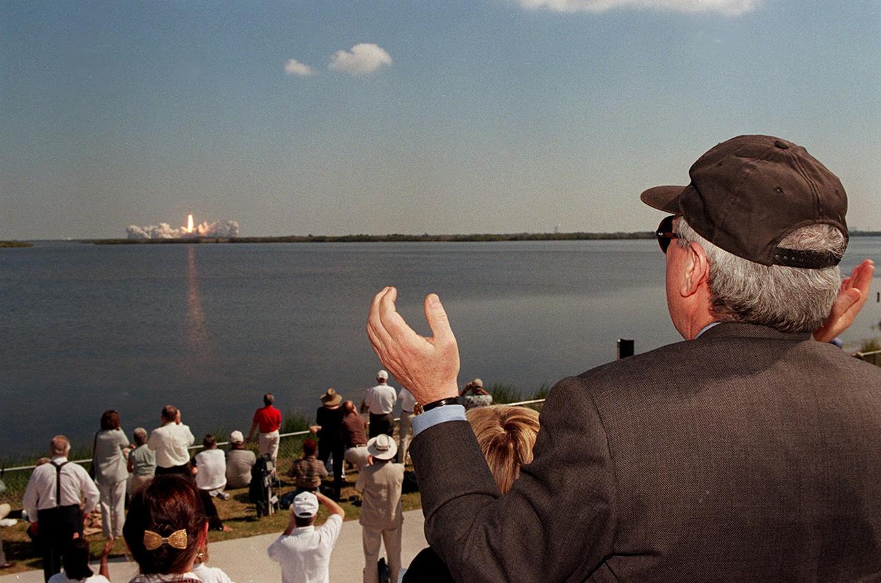
KENNEDY SPACE CENTER, FLA. -- NASA Administrator Dan Goldin (right) joins other spectators at the Banana Creek viewing site in cheering the successful launch of Space Shuttle Endeavour on mission STS-99. The perfect liftoff occurred at 12:43:40 p.m. EST. Known as the Shuttle Radar Topography Mission (SRTM), STS-99 will chart a new course to produce unrivaled 3-D images of the Earth's surface. The result of the SRTM could be close to 1 trillion measurements of the Earth's topography. The mission is expected to last 11days, with Endeavour landing at KSC Tuesday, Feb. 22, at 4:36 p.m. EST. This is the 97th Shuttle flight and 14th for Shuttle Endeavour

KENNEDY SPACE CENTER, FLA. -- This close-up of Space Shuttle Endeavour's main engines shows the replacement for main engine No. 3 (lower right) ready to be installed. Following routine testing procedures on a separate test engine, analysis revealed delamination on the wall of the engine's main combustion chamber. When data revealed that one of Endeavour's engines had undergone similar testing procedures, managers opted to replace the suspect engine as a precaution. Space Shuttle Endeavour is targeted for launch at 1:11 p.m. EST Jan. 13, 2000, on mission STS-99. It will be Endeavour's 14th flight. STS-99 is the Shuttle Radar Topography Mission

KENNEDY SPACE CENTER, FLA. -- NASA Administrator Dan Goldin (right) joins other spectators at the Banana Creek viewing site in cheering the successful launch of Space Shuttle Endeavour on mission STS-99. The perfect liftoff occurred at 12:43:40 p.m. EST. Known as the Shuttle Radar Topography Mission (SRTM), STS-99 will chart a new course to produce unrivaled 3-D images of the Earth's surface. The result of the SRTM could be close to 1 trillion measurements of the Earth's topography. The mission is expected to last 11days, with Endeavour landing at KSC Tuesday, Feb. 22, at 4:36 p.m. EST. This is the 97th Shuttle flight and 14th for Shuttle Endeavour
KENNEDY SPACE CENTER, Fla. -- Through the shrubs surrounding the water near Launch Pad 39A can be seen Space Shuttle Endeavour roaring into the clear blue Florida sky on mission STS-99. aunch of Endeavour occurred at 12:43:40 p.m. EST. Known as the Shuttle Radar Topography Mission (SRTM), STS-99 will chart a new course to produce unrivaled 3-D images of the Earth's surface. The result of the SRTM could be close to 1 trillion measurements of the Earth's topography. The mission is expected to last 11days, with Endeavour landing at KSC Tuesday, Feb. 22, at 4:36 p.m. EST. This is the 97th Shuttle flight and 14th for Shuttle Endeavour

KENNEDY SPACE CENTER, Fla. -- Twin columns of flame flow from the solid rocket boosters, lighting the billows of steam behind them with an orange glow, as Space Shuttle Endeavour roars into space on mission STS-99. Liftoff occurred at 12:43:40 p.m. EST. Known as the Shuttle Radar Topography Mission (SRTM), STS-99 will chart a new course to produce unrivaled 3-D images of the Earth's surface. The result of the SRTM could be close to 1 trillion measurements of the Earth's topography. The mission is expected to last 11days, with Endeavour landing at KSC Tuesday, Feb. 22, at 4:36 p.m. EST. This is the 97th Shuttle flight and 14th for Shuttle Endeavour
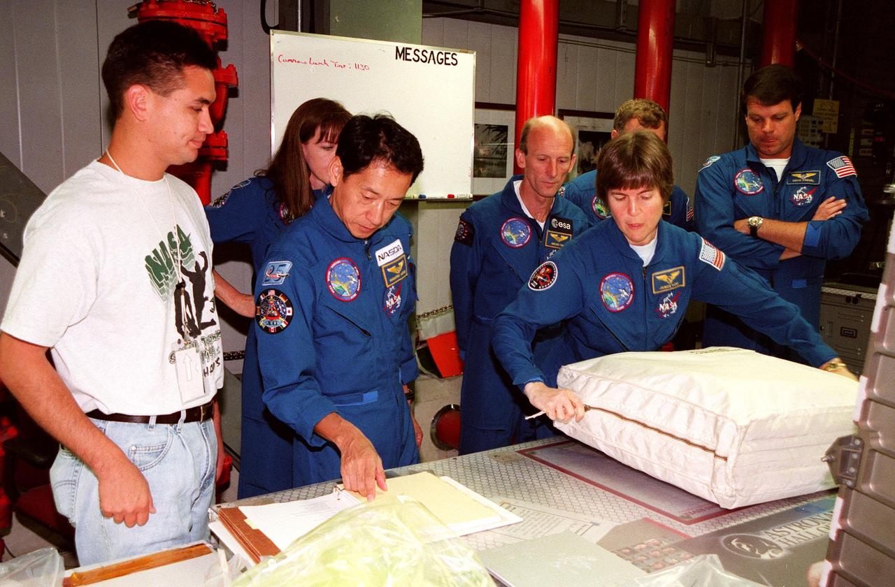
In the Orbiter Processing Facility (OPF) Bay 2, under the watchful eyes of a KSC worker (far left) the STS-99 crew look over equipment as part of a Crew Equipment Interface Test (CEIT). From left (second from right) are Mission Specialists Janet Lynn Kavandi (Ph.D.), Mamoru Mohri, Gerhard P.J. Thiele, and Janice Voss (Ph.D.); behind Voss are Pilot Dominic L. Pudwill Gorie and Commander Kevin R. Kregel. Mohri is with the National Space Development Agency (NASDA) of Japan, and Thiele is with the European Space Agency. The CEIT provides an opportunity for crew members to check equipment and facilities that will be aboard the orbiter during their mission. The STS-99 mission is the Shuttle Radar Topography Mission (SRTM), a specially modified radar system that will gather data for the most accurate and complete topographic map of the Earth's surface that has ever been assembled. SRTM will make use of radar interferometry, wherein two radar images are taken from slightly different locations. Differences between these images allow for the calculation of surface elevation, or change. The SRTM hardware will consist of one radar antenna in the shuttle payload bay and a second radar antenna attached to the end of a mast extended 60 meters (195 feet) out from the shuttle. STS-99 is scheduled to launch Sept. 16 at 8:47 a.m. from Launch Pad 39A

STS-99 Mission Specialist Mamoru Mohri of Japan and his wife, Akiko, wave before their departure from Patrick Air Force Base and return to Houston. With the postponement of the launch of STS-99 on Jan. 31, the crew have an opportunity for more training and time with their families. During the launch countdown, Endeavour's enhanced master events controller (E-MEC) No. 2 failed a standard preflight test. Launch was postponed and Shuttle managers decided to replace the E-MEC located in the orbiter's aft compartment. Launch controllers will be in a position to begin the STS-99 countdown the morning of Feb. 6 and ready to support a launch midto late next week pending availability of the Eastern Range. Known as the Shuttle Radar Topography Mission, it will chart a new course to produce unrivaled 3-D images of the Earth's surface, using two antennae and a 200-foot-long section of space station-derived mast protruding from the payload bay. The result could be close to 1 trillion measurements of the Earth's topography. Besides contributing to the production of better maps, these measurements could lead to improved water drainage modeling, more realistic flight simulators, better locations for cell phone towers, and enhanced navigation safety
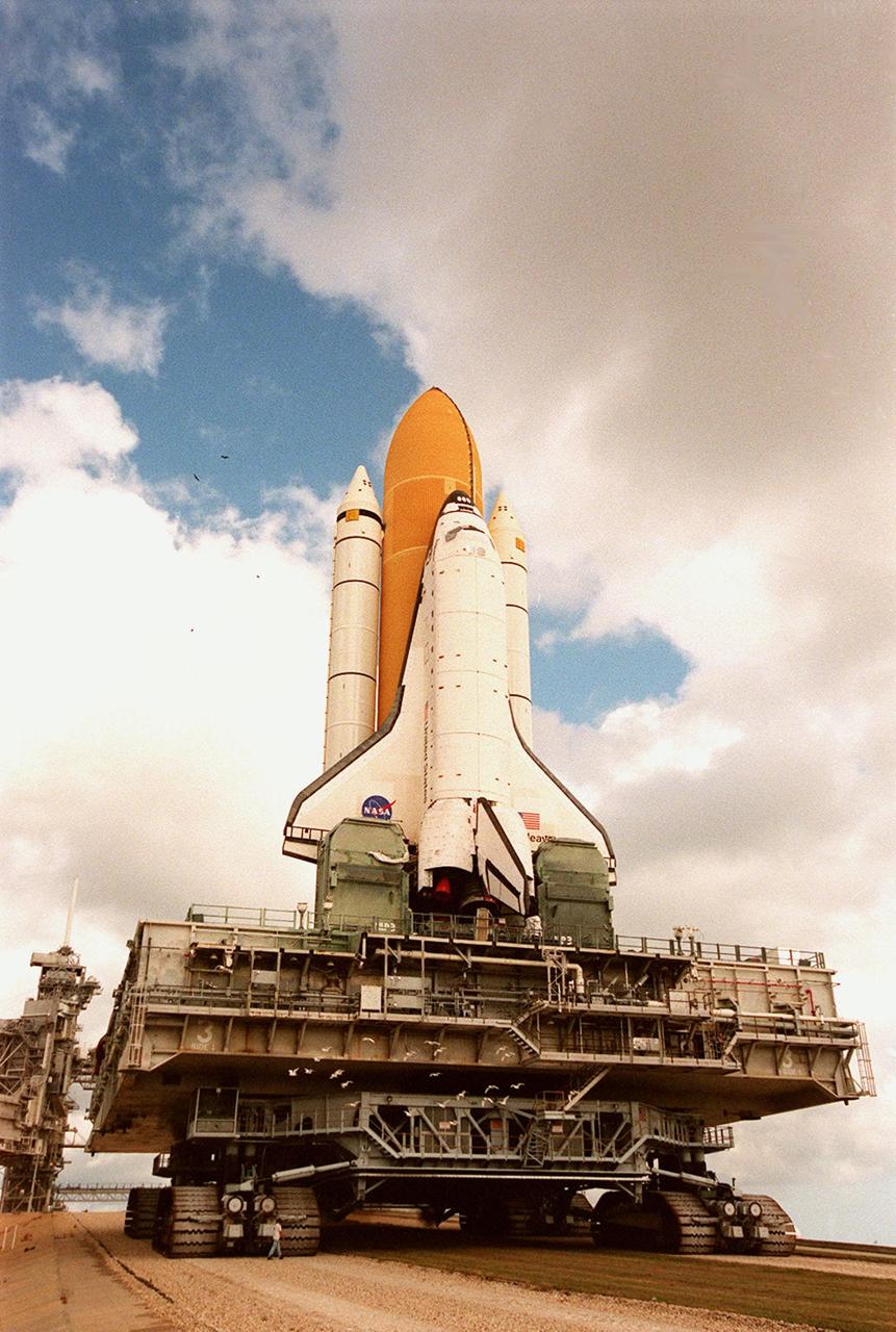
KENNEDY SPACE CENTER, Fla. -- Under breaking clouds, Space Shuttle Endeavour, atop the mobile launcher platform and crawler-transporter, crawls its way to Launch Pad 39A for mission STS-99. Named the Shuttle Radar Topography Mission (SRTM), STS-99 involves an international project spearheaded by the National Imagery and Mapping Agency and NASA, with participation of the German Aerospace Center DLR. SRTM will chart a new course, using two antennae and a 200-foot-long section of space station-derived mast protruding from its payload bay, to produce unrivaled 3-D images of the Earth's surface. The result of the Shuttle Radar Topography Mission could be close to 1 trillion measurements of the Earth's topography. Besides contributing to the production of better maps, these measurements could lead to improved water drainage modeling, more realistic flight simulators, better locations for cell phone towers, and enhanced navigation safety. STS-99 is scheduled for launch in January 2000
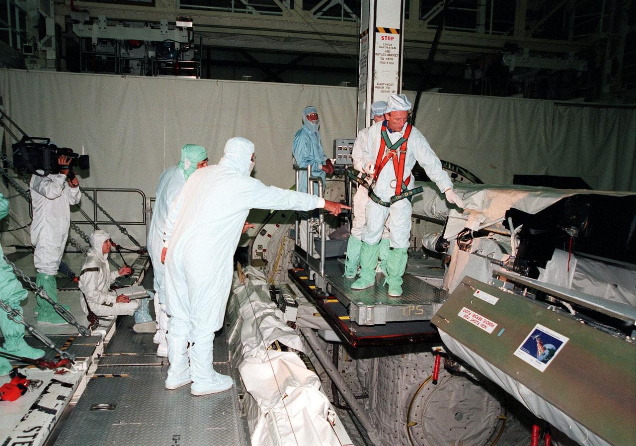
KENNEDY SPACE CENTER, FLA. -- In the Orbiter Processing Facility (OPF), the STS-99 crew take part in a Crew Equipment Interface Test (CEIT). Facing the camera and pointing is Mission Specialist Gerhard P.J. Thiele, who is with the European Space Agency. Other crew members in the OPF are Commander Kevin R. Kregel, Pilot Dominic L. Pudwill Gorie, and Mission Specialists Janet Lynn Kavandi (Ph.D.), Janice Voss (Ph.D.), and Mamoru Mohri, who is with the National Space Development Agency (NASDA) of Japan. The CEIT provides an opportunity for crew members to check equipment and facilities that will be aboard the orbiter during their mission. The STS-99 mission is the Shuttle Radar Topography Mission (SRTM), a specially modified radar system that will gather data for the most accurate and complete topographic map of the Earth's surface that has ever been assembled. SRTM will make use of radar interferometry, wherein two radar images are taken from slightly different locations. Differences between these images allow for the calculation of surface elevation, or change. The SRTM hardware will consist of one radar antenna in the shuttle payload bay and a second radar antenna attached to the end of a mast extended 60 meters (195 feet) out from the shuttle. STS-99 is scheduled to launch Sept. 16 at 8:47 a.m. from Launch Pad 39A

STS-99 Mission Specialist Mamoru Mohri of Japan and his wife, Akiko, wave before their departure from Patrick Air Force Base and return to Houston. With the postponement of the launch of STS-99 on Jan. 31, the crew have an opportunity for more training and time with their families. During the launch countdown, Endeavour's enhanced master events controller (E-MEC) No. 2 failed a standard preflight test. Launch was postponed and Shuttle managers decided to replace the E-MEC located in the orbiter's aft compartment. Launch controllers will be in a position to begin the STS-99 countdown the morning of Feb. 6 and ready to support a launch midto late next week pending availability of the Eastern Range. Known as the Shuttle Radar Topography Mission, it will chart a new course to produce unrivaled 3-D images of the Earth's surface, using two antennae and a 200-foot-long section of space station-derived mast protruding from the payload bay. The result could be close to 1 trillion measurements of the Earth's topography. Besides contributing to the production of better maps, these measurements could lead to improved water drainage modeling, more realistic flight simulators, better locations for cell phone towers, and enhanced navigation safety

STS-99 Mission Specialist Mamoru Mohri of Japan waves before his departure from Patrick Air Force Base and return to Houston. With the postponement of the launch of STS-99 on Jan. 31, the crew have an opportunity for more training and time with their families. During the launch countdown, Endeavour's enhanced master events controller (E-MEC) No. 2 failed a standard preflight test. Launch was postponed and Shuttle managers decided to replace the E-MEC located in the orbiter's aft compartment. Launch controllers will be in a position to begin the STS-99 countdown the morning of Feb. 6 and ready to support a launch midto late next week pending availability of the Eastern Range. Known as the Shuttle Radar Topography Mission, it will chart a new course to produce unrivaled 3-D images of the Earth's surface, using two antennae and a 200-foot-long section of space station-derived mast protruding from the payload bay. The result could be close to 1 trillion measurements of the Earth's topography. Besides contributing to the production of better maps, these measurements could lead to improved water drainage modeling, more realistic flight simulators, better locations for cell phone towers, and enhanced navigation safety
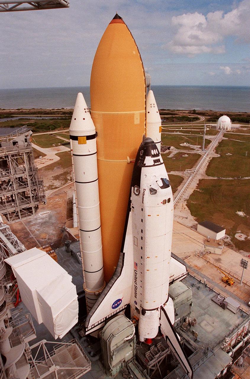
KENNEDY SPACE CENTER, Fla. -- Under partly cloudy skies and the Atlantic Ocean as a backdrop, Space Shuttle Endeavour, atop the mobile launcher platform, arrives at Launch Pad 39A for mission STS-99. The white cubicle at left is the environmental chamber, the White Room, that provides entry into the orbiter for the astronauts. It is at the outer end of the Orbiter Access Arm on the Fixed Service Structure. STS-99, named the Shuttle Radar Topography Mission (SRTM), involves an international project spearheaded by the National Imagery and Mapping Agency and NASA, with participation of the German Aerospace Center DLR. SRTM will chart a new course, using two antennae and a 200-foot-long section of space station-derived mast protruding from its payload bay, to produce unrivaled 3-D images of the Earth's surface. The result of the Shuttle Radar Topography Mission could be close to 1 trillion measurements of the Earth's topography. Besides contributing to the production of better maps, these measurements could lead to improved water drainage modeling, more realistic flight simulators, better locations for cell phone towers, and enhanced navigation safety. STS-99 is scheduled for launch in January 2000

STS-99 Mission Specialist Mamoru Mohri of Japan waves before his departure from Patrick Air Force Base and return to Houston. With the postponement of the launch of STS-99 on Jan. 31, the crew have an opportunity for more training and time with their families. During the launch countdown, Endeavour's enhanced master events controller (E-MEC) No. 2 failed a standard preflight test. Launch was postponed and Shuttle managers decided to replace the E-MEC located in the orbiter's aft compartment. Launch controllers will be in a position to begin the STS-99 countdown the morning of Feb. 6 and ready to support a launch midto late next week pending availability of the Eastern Range. Known as the Shuttle Radar Topography Mission, it will chart a new course to produce unrivaled 3-D images of the Earth's surface, using two antennae and a 200-foot-long section of space station-derived mast protruding from the payload bay. The result could be close to 1 trillion measurements of the Earth's topography. Besides contributing to the production of better maps, these measurements could lead to improved water drainage modeling, more realistic flight simulators, better locations for cell phone towers, and enhanced navigation safety