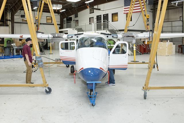
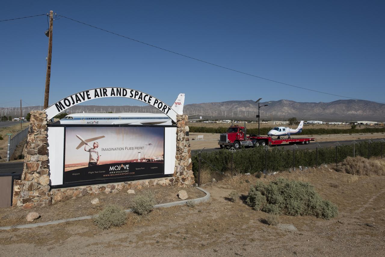
The Tecnam P2006T undergoes wing integration at Scaled Composites in Mojave, California, where the aircraft’s system will be converted to feature electric propulsion.

Scaled Composites' unique tandem-wing Proteus was the testbed for a series of UAV collision-avoidance flight demonstrations. An Amphitech 35GHz radar unit installed below Proteus' nose was the primary sensor for the Detect, See and Avoid tests.

Scaled Composites' unique tandem-wing Proteus was the testbed for a series of UAV collision-avoidance flight demonstrations. An Amphitech 35GHz radar unit installed below Proteus' nose was the primary sensor for the Detect, See and Avoid tests.
Scaled Composites' unique tandem-wing Proteus was the testbed for a series of UAV collision-avoidance flight demonstrations. An Amphitech 35GHz radar unit installed below Proteus' nose was the primary sensor for the Detect, See and Avoid tests.

Scaled Composites' Proteus aircraft and an F/A-18 Hornet from NASA's Dryden Flight Research Center at Mojave Airport in Southern California. The unique tandem-wing Proteus was the testbed for a series of UAV collision-avoidance flight demonstrations. An Amphitech 35GHz radar unit installed below Proteus' nose was the primary sensor for the Detect, See and Avoid tests. NASA Dryden's F/A-18 Hornet was one of many different aircraft used in the tests.

NASA Administrator Bridenstine talks to press at Scaled Composites hangar at Mojave Air & Space Port in California. He talks about X-planes and their future and the Flight Opportunities program as well as commercial space partnerships with the agency.

NASA Administrator Bridenstine talks to press at Scaled Composites hangar at Mojave Air & Space Port in California. He talks about X-planes and their future and the Flight Opportunities program as well as commercial space partnerships with the agency.
An Amphitech OASys Ka-band radar was the primary sensor installed on Scaled Composites' Proteus for the second phase of NASA-sponsored unmanned aerial vehicle Detect, See and Avoid flight tests.

Scaled Composites' Proteus aircraft with an F/A-18 Hornet and a Beechcraft KingAir from NASA's Dryden Flight Research Center during a low-level flyby at Mojave Airport in Southern California. The unique tandem-wing Proteus was the testbed for a series of UAV collision-avoidance flight demonstrations. An Amphitech 35GHz radar unit installed below Proteus' nose was the primary sensor for the Detect, See and Avoid tests.

Administrator Bridenstine receives X-57 program patch standing in front of the X-57 being modified from combustion Tecnam P2006T aircraft into all-electric aircraft in Scaled Composites hangar at Mojave Air & Space Port in California.

Scaled Composites' Proteus aircraft and an F/A-18 Hornet from NASA's Dryden Flight Research Center during a low-level flyby at Las Cruces Airport in New Mexico.
NASA Mars 2020 rover would have capabilities for nested-scale observations and localized composition identification down to microscopic scale.
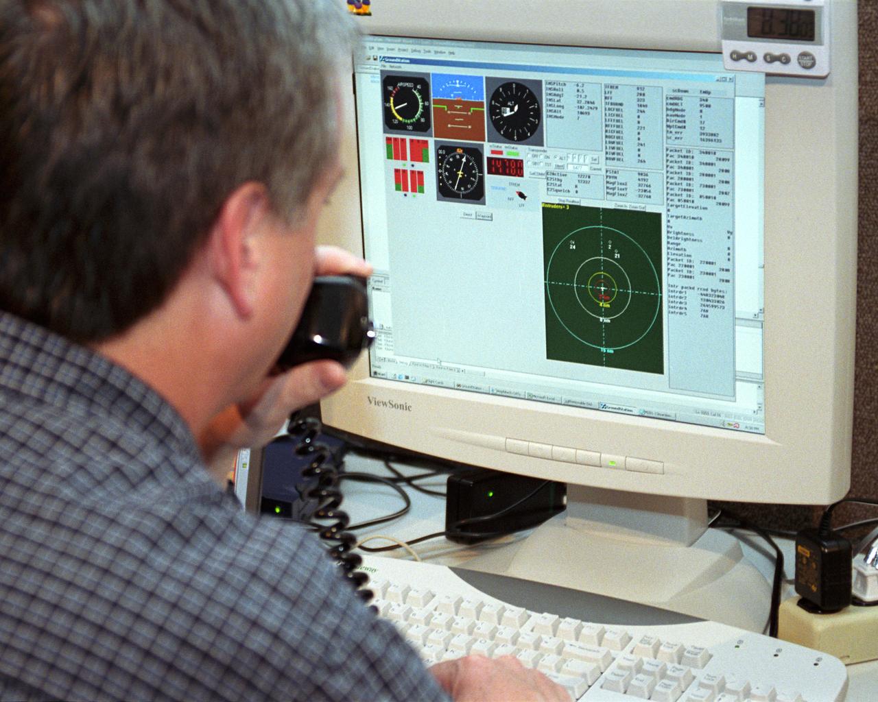
Scaled Composites' Doug Shane examines the screen of his ground control station during tests in New Mexico. Shane used this configuration as the ground control station to remotely pilot the Proteus aircraft during a NASA sponsored series of tests.

Proteus DSA control room in Mojave, CA (L to R) Jean-Pierre Soucy; Amphitech International Software engineer Craig Bomben; NASA Dryden Test Pilot Pete Siebold; (with headset, at computer controls) Scaled Composites pilot Bob Roehm; New Mexico State University (NMSU) UAV Technical Analysis Application Center (TAAC) Chuck Coleman; Scaled Composites Pilot Kari Sortland; NMSU TAAC Russell Wolfe; Modern Technology Solutions, Inc. Scaled Composites' unique tandem-wing Proteus was the testbed for a series of UAV collision-avoidance flight demonstrations. An Amphitech 35GHz radar unit installed below Proteus' nose was the primary sensor for the Detect, See and Avoid tests.

This photo composite shows an aerial view of FedEx Field in Landover, Md., home of the Washington Redskins, superimposed on Mars Victoria Crater to give a sense of the crater scale.
This composite image was made from NASA Cassini which captured a significant portion of the Moon during a Moon flyby imaging sequence.All three images have been scaled so that the brightness of Crisium basin, the dark circular region in the upper right,

NASA Ames Graphics of LARGE-SCALE TILTING PROP ROTOR HOVER PERFORMANCE TESTS AMES OARF COMPOSITE. (ref: XV-15 Metal Rotor AC84-0176-13, XV-15 Composite Rotor from AC84-0498 series, V-22 Osprey AC84-0059-11 testing at OARF)
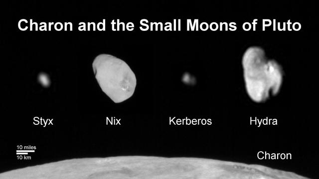
This composite image shows a sliver of Pluto large moon, Charon, and all four of Pluto small moons, as resolved by the Long Range Reconnaissance Imager (LORRI) on the New Horizons spacecraft. All the moons are displayed with a common intensity stretch and spatial scale (see scale bar). Charon is by far the largest of Pluto's moons, with a diameter of 751 miles (1,212 kilometers). Nix and Hydra have comparable sizes, approximately 25 miles (40 kilometers) across in their longest dimension above. Kerberos and Styx are much smaller and have comparable sizes, roughly 6-7 miles (10-12 kilometers) across in their longest dimension. All four small moons have highly elongated shapes, a characteristic thought to be typical of small bodies in the Kuiper Belt. http://photojournal.jpl.nasa.gov/catalog/PIA20033

Proteus and an F/A-18 Hornet from NASA's Dryden Flight Research Center are seen here in flight over Las Cruces, New Mexico.
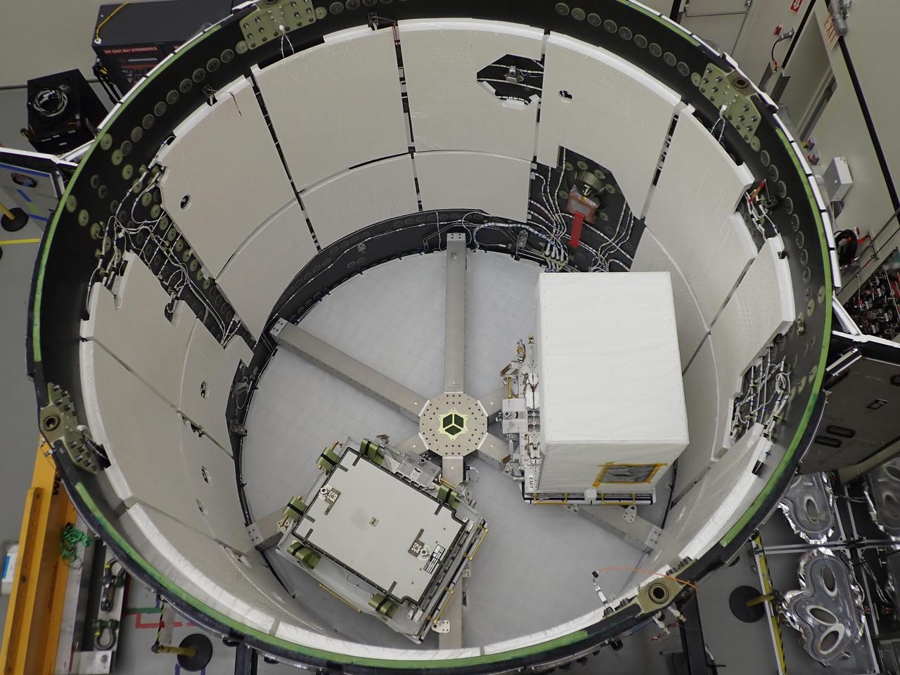
NASA’s all-electric X-57 Maxwell, in its Mod II configuration, departs Scaled Composites’ facility at Mojave Air and Space Port, en route to NASA’s Armstrong Flight Research Center in Edwards, California for delivery. The aircraft, shipped as two parts – the fuselage and the wing – was delivered to NASA Armstrong’s Research Aircraft Integration Facility, where it will be reintegrated to begin ground tests, to be followed by taxi tests, and eventually, flight tests. X-57’s Mod II configuration, the first of three primary modifications for the project, involves testing of the aircraft’s cruise electric propulsion system. The goal of the X-57 project is to share the aircraft’s electric-propulsion-focused design and airworthiness process with regulators, to advance certification approaches for distributed electric propulsion in general aviation.

NASA's all-electric X-57 Maxwell, in its Mod II configuration, departs Scaled Composites' facility at Mojave Air and Space Port, en route to NASA's Armstrong Flight Research Center in Edwards, California for delivery. The aircraft, shipped as two parts - the fuselage and the wing - was delivered to NASA Armstrong's Research Aircraft Integration Facility, where it will be reintegrated to begin ground tests, to be followed by taxi tests, and eventually, flight tests. X-57's Mod II configuration, the first of three primary modifications for the project, involves testing of the aircraft's cruise electric propulsion system. The goal of the X-57 project is to share the aircraft's electric-propulsion-focused design and airworthiness process with regulators, to advance certification approaches for distributed electric propulsion in general aviation.
NASA’s all-electric X-57 Maxwell, in its Mod II configuration, departs Scaled Composites’ facility at Mojave Air and Space Port, en route to NASA’s Armstrong Flight Research Center in Edwards, California for delivery. The aircraft, shipped as two parts – the fuselage and the wing – was delivered to NASA Armstrong’s Research Aircraft Integration Facility, where it will be reintegrated to begin ground tests, to be followed by taxi tests, and eventually, flight tests. X-57’s Mod II configuration, the first of three primary modifications for the project, involves testing of the aircraft’s cruise electric propulsion system. The goal of the X-57 project is to share the aircraft’s electric-propulsion-focused design and airworthiness process with regulators, to advance certification approaches for distributed electric propulsion in general aviation.
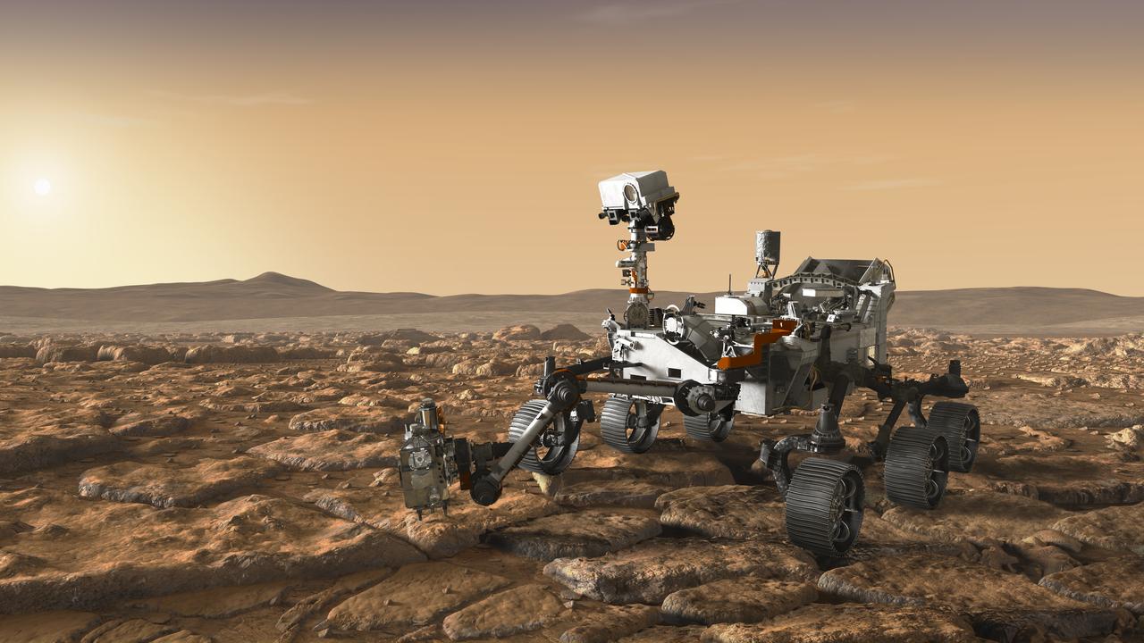
This artist's concept depicts NASA's Mars 2020 rover exploring Mars. The mission will not only seek out and study an area likely to have been habitable in the distant past, but it will take the next, bold step in robotic exploration of the Red Planet by seeking signs of past microbial life itself. Mars 2020 will use powerful instruments to investigate rocks on Mars down to the microscopic scale of variations in texture and composition. It will also acquire and store samples of the most promising rocks and soils that it encounters, and set them aside on the surface of Mars. A future mission could potentially return these samples to Earth. Mars 2020 is targeted for launch in July/August 2020 aboard an Atlas V-541 rocket from Space Launch Complex 41 at Cape Canaveral Air Force Station in Florida. https://photojournal.jpl.nasa.gov/catalog/PIA22107
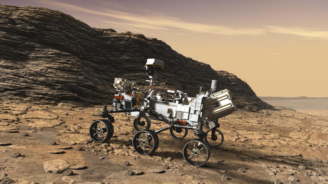
This artist's concept shows a close-up of NASA's Mars 2020 rover studying an outcrop. The mission will not only seek out and study an area likely to have been habitable in the distant past, but it will take the next, bold step in robotic exploration of the Red Planet by seeking signs of past microbial life itself. Mars 2020 will use powerful instruments to investigate rocks on Mars down to the microscopic scale of variations in texture and composition. It will also acquire and store samples of the most promising rocks and soils that it encounters, and set them aside on the surface of Mars. A future mission could potentially return these samples to Earth. Mars 2020 is targeted for launch in July/August 2020 aboard an Atlas V-541 rocket from Space Launch Complex 41 at Cape Canaveral Air Force Station in Florida. https://photojournal.jpl.nasa.gov/catalog/PIA22108
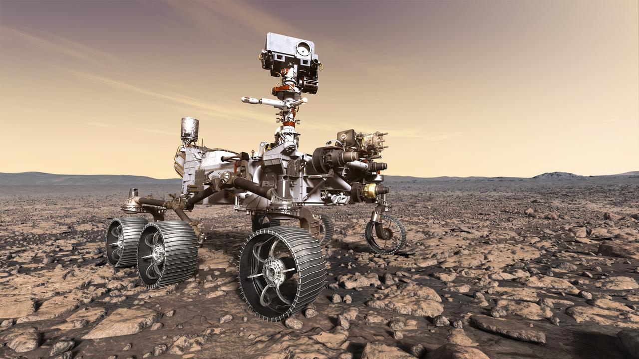
This artist's rendition depicts NASA's Mars 2020 rover studying its surroundings. The mission will not only seek out and study an area likely to have been habitable in the distant past, but it will take the next, bold step in robotic exploration of the Red Planet by seeking signs of past microbial life itself. Mars 2020 will use powerful instruments to investigate rocks on Mars down to the microscopic scale of variations in texture and composition. It will also acquire and store samples of the most promising rocks and soils that it encounters, and set them aside on the surface of Mars. A future mission could potentially return these samples to Earth. Mars 2020 is targeted for launch in July/August 2020 aboard an Atlas V-541 rocket from Space Launch Complex 41 at Cape Canaveral Air Force Station in Florida. https://photojournal.jpl.nasa.gov/catalog/PIA22109
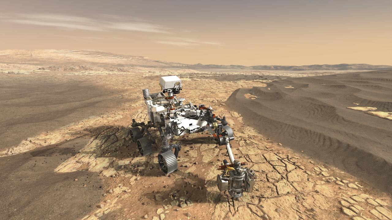
This artist's concept depicts NASA's Mars 2020 rover exploring Mars. The mission will not only seek out and study an area likely to have been habitable in the distant past, but it will take the next, bold step in robotic exploration of the Red Planet by seeking signs of past microbial life itself. Mars 2020 will use powerful instruments to investigate rocks on Mars down to the microscopic scale of variations in texture and composition. It will also acquire and store samples of the most promising rocks and soils that it encounters, and set them aside on the surface of Mars. A future mission could potentially return these samples to Earth. Mars 2020 is targeted for launch in July/August 2020 aboard an Atlas V-541 rocket from Space Launch Complex 41 at Cape Canaveral Air Force Station in Florida. https://photojournal.jpl.nasa.gov/catalog/PIA22111
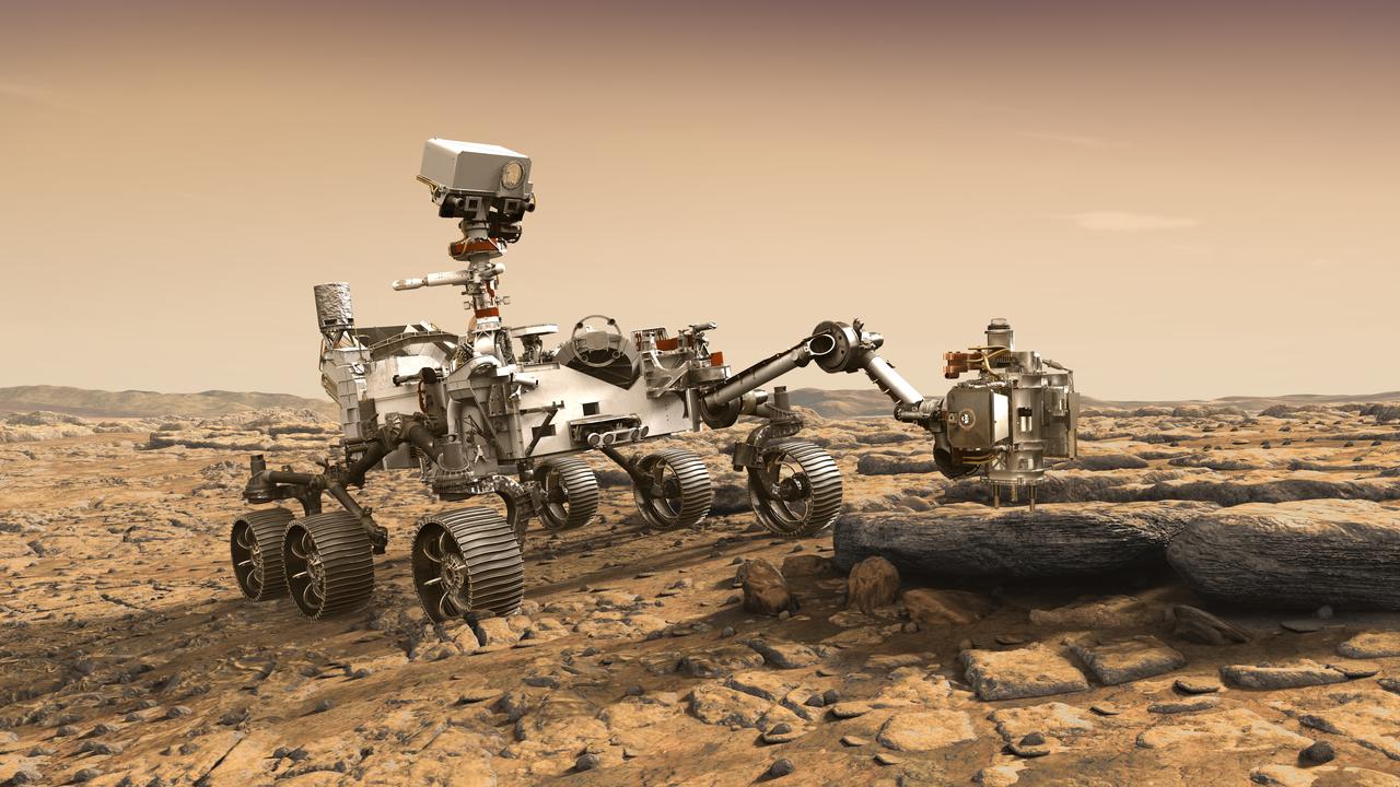
This artist's rendition depicts NASA's Mars 2020 rover studying a Mars rock outrcrop. The mission will not only seek out and study an area likely to have been habitable in the distant past, but it will take the next, bold step in robotic exploration of the Red Planet by seeking signs of past microbial life itself. Mars 2020 will use powerful instruments to investigate rocks on Mars down to the microscopic scale of variations in texture and composition. It will also acquire and store samples of the most promising rocks and soils that it encounters, and set them aside on the surface of Mars. A future mission could potentially return these samples to Earth. Mars 2020 is targeted for launch in July/August 2020 aboard an Atlas V-541 rocket from Space Launch Complex 41 at Cape Canaveral Air Force Station in Florida. https://photojournal.jpl.nasa.gov/catalog/PIA22105
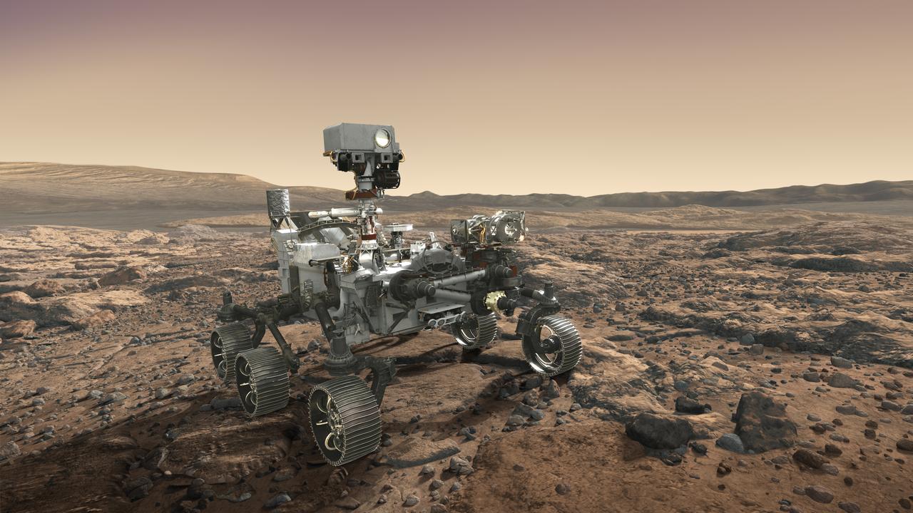
NASA's Mars 2020 rover looks at the horizon in this artist's concept. The mission will not only seek out and study an area likely to have been habitable in the distant past, but it will take the next, bold step in robotic exploration of the Red Planet by seeking signs of past microbial life itself. Mars 2020 will use powerful instruments to investigate rocks on Mars down to the microscopic scale of variations in texture and composition. It will also acquire and store samples of the most promising rocks and soils that it encounters, and set them aside on the surface of Mars. A future mission could potentially return these samples to Earth. Mars 2020 is targeted for launch in July/August 2020 aboard an Atlas V-541 rocket from Space Launch Complex 41 at Cape Canaveral Air Force Station in Florida. https://photojournal.jpl.nasa.gov/catalog/PIA22110
![Layers, probably sedimentary in origin, have undergone extensive erosion in this image from NASA's Mars Reconnaissance Orbiter (MRO) of Shalbatana Valles, a prominent channel that cuts through Xanthe Terra. This erosion has produced several small mesas and exposed light-toned material that may differ in composition from the surrounding material. The map is projected here at a scale of 25 centimeters (9.8 inches) per pixel. [The original image scale is 27.5 centimeters (10.8 inches) per pixel (with 1 x 1 binning); objects on the order of 82 centimeters (32.3 inches) across are resolved.] North is up. https://photojournal.jpl.nasa.gov/catalog/PIA22182](https://images-assets.nasa.gov/image/PIA22182/PIA22182~medium.jpg)
Layers, probably sedimentary in origin, have undergone extensive erosion in this image from NASA's Mars Reconnaissance Orbiter (MRO) of Shalbatana Valles, a prominent channel that cuts through Xanthe Terra. This erosion has produced several small mesas and exposed light-toned material that may differ in composition from the surrounding material. The map is projected here at a scale of 25 centimeters (9.8 inches) per pixel. [The original image scale is 27.5 centimeters (10.8 inches) per pixel (with 1 x 1 binning); objects on the order of 82 centimeters (32.3 inches) across are resolved.] North is up. https://photojournal.jpl.nasa.gov/catalog/PIA22182
The Proteus high-altitude aircraft on the ramp at the Mojave Airport in Mojave, California.

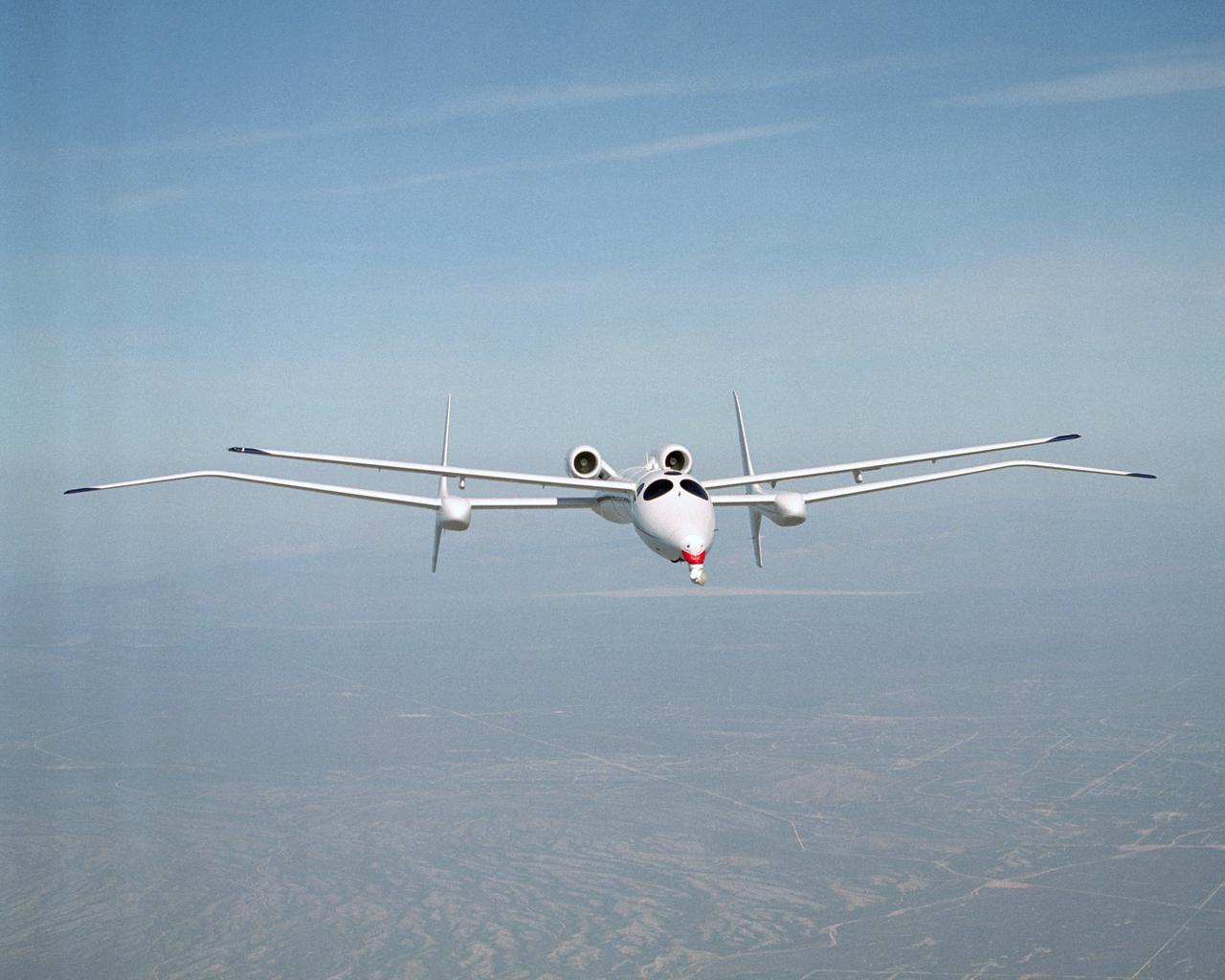
The unusual design of the Proteus high-altitude aircraft, incorporating a gull-wing shape for its main wing and a long, slender forward canard, is clearly visible in this view of the aircraft in flight over the Mojave Desert in California.

The uniquely shaped Proteus high-altitude aircraft soars over California’s Mojave Desert during a July 1999 flight.

The unusual design of the Proteus high-altitude aircraft, incorporating a gull-wing shape for its main wing and a long, slender forward canard, is clearly visible in this view of the aircraft in flight over the Mojave Desert in California.
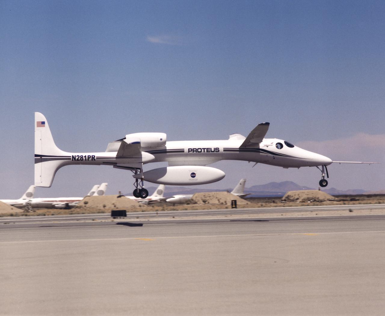
The uniquely-shaped Proteus high-altitude research aircraft lifts off from the runway at the Mojave Airport in Mojave, California.

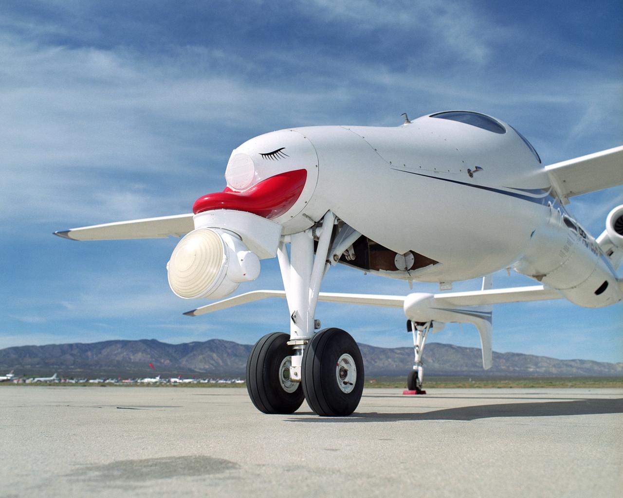
A frontal view of the Proteus high-altitude aircraft on the ramp at the Mojave Airport in Mojave, California in July 1999.
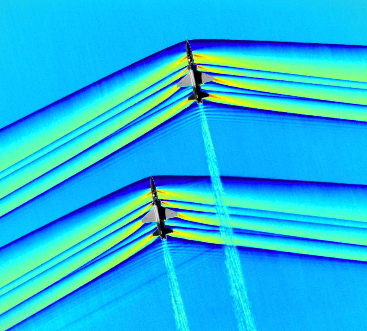
Composite image of Background Oriented Schlieren (BOS) data (contour) with a cut-out images of the T-38’s during a Mach Number 1.01 pass. This data is the first time shockwave interactions between two full scale aircraft traveling faster than the speed of sound have been imaged and shown with schlieren visualization. Original recording of the pass taken in the Black Mountain Supersonic Corridor at near Edwards AFB in December of 2018. Image acquired by JT Heineck, schlieren data processed by Neal Smith

Composite image of Background Oriented Schlieren (BOS) data (contour) with a cut-out images of the T-38’s during a Mach Number 1.01 pass. This data is the first time shockwave interactions between two full scale aircraft traveling faster than the speed of sound have been imaged and shown with schlieren visualization. Original recording of the pass taken in the Black Mountain Supersonic Corridor at near Edwards AFB in December of 2018. Image acquired by JT Heineck, schlieren data processed by Neal Smith.
S72-53470 (November 1972) --- The Far-Ultraviolet Spectrometer, Experiment S-169, one of the lunar orbital science experiments which will be mounted in the SIM bay of the Apollo 17 Service Module. Controls for activating and deactivating the experiment and for opening and closing a protective cover are located in the Command Module. Atomic composition, density and scale height for several constituents of the lunar atmosphere will be measured by the far-ultraviolet spectrometer. Solar far-UV radiation reflected from the lunar surface as well as UV radiation emitted by galactic sources also will be detected by the instrument.

Composite image of Background Oriented Schlieren (BOS) data (contour) with a cut-out images of the T-38’s during a Mach Number 1.01 pass. This data is the first time shockwave interactions between two full scale aircraft traveling faster than the speed of sound have been imaged and shown with schlieren visualization. Original recording of the pass taken in the Black Mountain Supersonic Corridor at near Edwards AFB in December of 2018. Image acquired by JT Heineck, schlieren data processed by Neal Smith

Administrator Bridenstine hears about the progress to modify the Tecnam P2006T from a combustion aircraft to an all-electric aircraft. Armstrong's X-57 team and ESAero, the prime contractor for the plane, are doing the briefing. The final configuration model of X-57 stands in front of group.

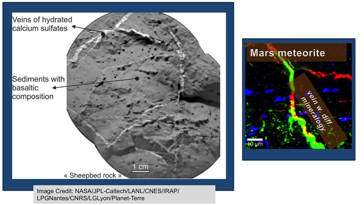
NASA's Curiosity Mars rover examined both the "Greenhorn" and "Big Sky" targets with the rover's Alpha Particle X-ray Spectrometer (APXS) instrument. Greenhorn is located within an altered fracture zone and has an elevated concentration of silica (about 60 percent by weight). Big Sky is the unaltered counterpart for comparison. The bar plot on the left shows scaled concentrations as analyzed by Curiosity's APXS. The bar plot on the right shows what the Big Sky composition would look like if silica (SiO2) and calcium-sulfate (both abumdant in Greenhorn) were added. The similarity in the resulting composition suggests that much of the chemistry of Greenhorn could be explained by the addition of silica. Ongoing research aims to distinguish between that possible explanation for silicon enrichment and an alternative of silicon being left behind when some other elements were removed by acid weathering. http://photojournal.jpl.nasa.gov/catalog/PIA20275
![This image from NASA's Mars Reconnaissance Orbiter (MRO) shows the eastern rim of a small 3.5-kilometer crater which appears to have collapsed into a much larger crater (about 14-kilometers wide). The larger crater has a large ice flow around its central peak, and is non-circular, with large blocks further suggesting structural collapse of the terrain due to what are called periglacial processes. Understanding the composition of this small crater may inform us of the ice content of the surrounding terrain. The map is projected here at a scale of 50 centimeters (19.7 inches) per pixel. [The original image scale is 50.8 centimeters (20 inches) per pixel (with 2 x 2 binning); objects on the order of 152 centimeters (59.8 inches) across are resolved.] North is up. https://photojournal.jpl.nasa.gov/catalog/PIA22116](https://images-assets.nasa.gov/image/PIA22116/PIA22116~medium.jpg)
This image from NASA's Mars Reconnaissance Orbiter (MRO) shows the eastern rim of a small 3.5-kilometer crater which appears to have collapsed into a much larger crater (about 14-kilometers wide). The larger crater has a large ice flow around its central peak, and is non-circular, with large blocks further suggesting structural collapse of the terrain due to what are called periglacial processes. Understanding the composition of this small crater may inform us of the ice content of the surrounding terrain. The map is projected here at a scale of 50 centimeters (19.7 inches) per pixel. [The original image scale is 50.8 centimeters (20 inches) per pixel (with 2 x 2 binning); objects on the order of 152 centimeters (59.8 inches) across are resolved.] North is up. https://photojournal.jpl.nasa.gov/catalog/PIA22116
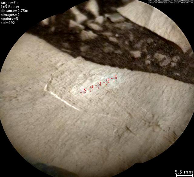
This image from the Chemistry and Camera (ChemCam) instrument on NASA's Curiosity Mars rover shows detailed texture of a rock target called "Elk" on Mars' Mount Sharp, revealing laminations that are present in much of the Murray Formation geological unit of lower Mount Sharp. Researchers also used ChemCam's laser and spectrometers to assess Elk's composition and found it to be rich in silica. The image covers a patch of rock surface about 2.8 inches (7 centimeters) across. It was taken on May 22, 2015, during the mission's 992nd Martian day, or sol. ChemCam's Remote Micro-Imager camera, on top of Curiosity's mast, captured the image from a distance of about 9 feet (2.75 meters). Annotations in red identify five points on Elk that were hit with ChemCam's laser. Each of the highlighted points is a location where ChemCam fired its laser 30 times to ablate a tiny amount of target material. By analyzing the light emitted from this laser-ablation, researchers can deduce the composition of that point. For some purposes, composition is presented as a combination of the information from multiple points on the same rock. However, using the points individually can track fine-scale variations in targets. http://photojournal.jpl.nasa.gov/catalog/PIA20267
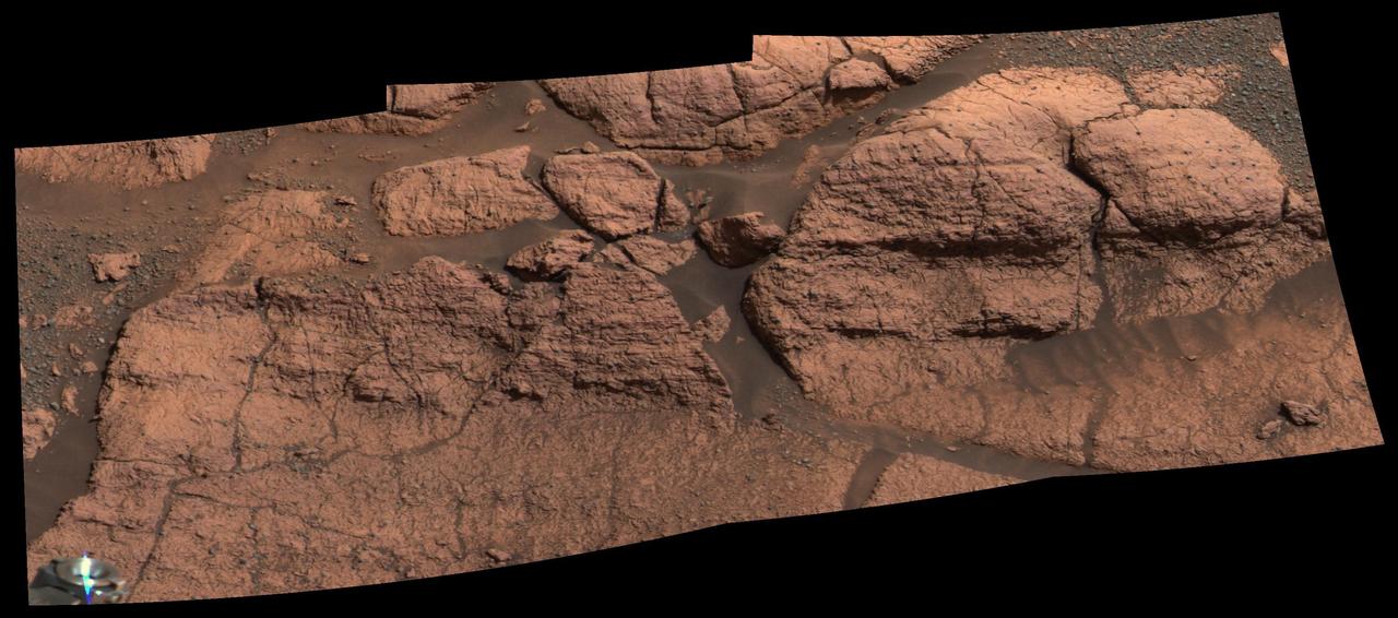
This mosaic of images taken by the panoramic camera onboard the Mars Exploration Rover Opportunity shows the rock region dubbed "El Capitan," which lies within the larger outcrop near the rover's landing site. "El Capitan" is being studied in great detail using the scientific instruments on the rover's arm; images from the panoramic camera help scientists choose the locations for this compositional work. The millimeter-scale detail of the lamination covering these rocks can be seen. The face of the rock to the right of the mosaic may be a future target for grinding with the rover's rock abrasion tool. http://photojournal.jpl.nasa.gov/catalog/PIA05492
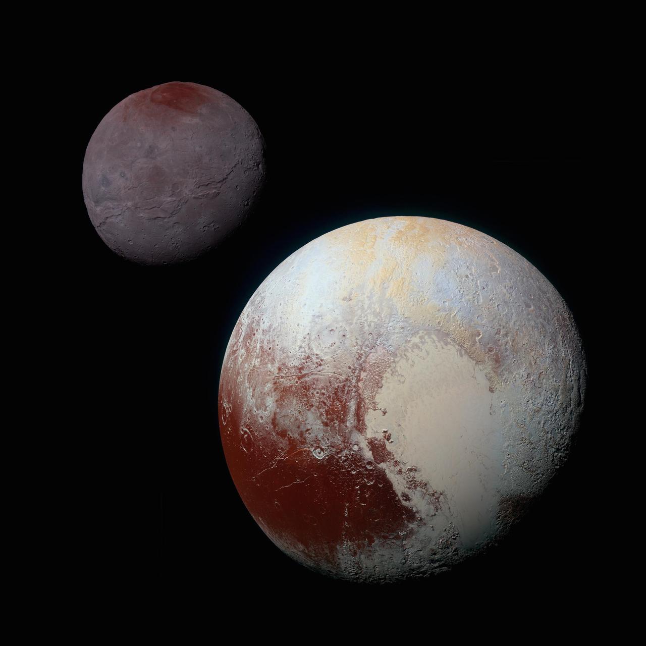
A composite of enhanced color images of Pluto (lower right) and Charon (upper left), taken by NASA's New Horizons spacecraft as it passed through the Pluto system on July 14, 2015. This image highlights the striking differences between Pluto and Charon. The color and brightness of both Pluto and Charon have been processed identically to allow direct comparison of their surface properties, and to highlight the similarity between Charon's polar red terrain and Pluto's equatorial red terrain. Pluto and Charon are shown with approximately correct relative sizes, but their true separation is not to scale. The image combines blue, red and infrared images taken by the spacecraft's Ralph/Multispectral Visual Imaging Camera (MVIC). http://photojournal.jpl.nasa.gov/catalog/PIA19966
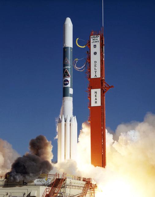
The Near Earth Asteroid Rendezvous (NEAR) spacecraft embarks on a journey that will culminate in a close encounter with an asteroid. The launch of NEAR inaugurates NASA's irnovative Discovery program of small-scale planetary missions with rapid, lower-cost development cycles and focused science objectives. NEAR will rendezvous in 1999 with the asteroid 433 Eros to begin the first long-term, close-up look at an asteroid's surface composition and physical properties. NEAR's science payload includes an x-ray/gamma ray spectrometer, an near-infrared spectrograph, a laser rangefinder, a magnetometer, a radio science experiment and a multi-spectral imager.
This mosaic is composed of about 100 red- and violet- filter Viking Orbiter images, digitally mosaiced in an orthographic projection at a scale of 1 km/pixel. The images were acquired in 1980 during mid northern summer on Mars (Ls = 89 degrees). The center of the image is near the impact crater Schiaparelli (latitude -3 degrees, longitude 343 degrees). The limits of this mosaic are approximately latitude -60 to 60 degrees and longitude 280 to 30 degrees. The color variations have been enhanced by a factor of two, and the large-scale brightness variations (mostly due to sun-angle variations) have been normalized by large-scale filtering. The large circular area with a bright yellow color (in this rendition) is known as Arabia. The boundary between the ancient, heavily-cratered southern highlands and the younger northern plains occurs far to the north (latitude 40 degrees) on this side of the planet, just north of Arabia. The dark streaks with bright margins emanating from craters in the Oxia Palus region (to the left of Arabia) are caused by erosion and/or deposition by the wind. The dark blue area on the far right, called Syrtis Major Planum, is a low-relief volcanic shield of probable basaltic composition. Bright white areas to the south, including the Hellas impact basin at the lower right, are covered by carbon dioxide frost. http://photojournal.jpl.nasa.gov/catalog/PIA00004
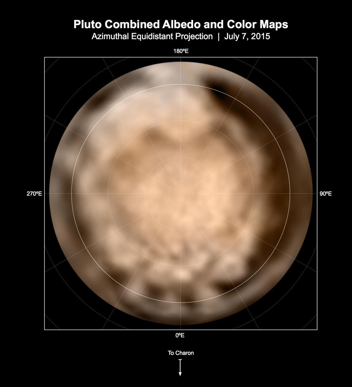
These circular maps shows the distribution of Pluto's dark and bright terrains as revealed by NASA's New Horizons mission prior to July 4, 2015. Each map is an azimuthal equidistant projection centered on the north pole, with latitude and longitude indicated. Both a gray-scale and color version are shown. The gray-scale version is based on 7 days of panchromatic imaging from the Long Range Reconnaissance Imager (LORRI), whereas the color version uses the gray-scale base and incorporates lower-resolution color information from the Multi-spectral Visible Imaging Camera (MVIC), part of the Ralph instrument. The color version is also shown in a simple cylindrical projection in PIA19700. In these maps, the polar bright terrain is surrounded by a somewhat darker polar fringe, one whose latitudinal position varies strongly with longitude. Especially striking are the much darker regions along the equator. A broad dark swath ("the whale") stretches along the equator from approximately 20 to 160 degrees of longitude. Several dark patches appear in a regular sequence centered near 345 degrees of longitude. A spectacular bright region occupies Pluto's mid-latitudes near 180 degrees of longitude, and stretches southward over the equator. New Horizons' closest approach to Pluto will occur near this longitude, which will permit high-resolution visible imaging and compositional mapping of these various regions. http://photojournal.jpl.nasa.gov/catalog/PIA19706
Data from NASA's Galileo spacecraft were used to produce this false-color composite of Jupiter's northern aurora on the night side of the planet. The height of the aurora, the thickness of the auroral arc, and the small-scale structure are revealed for the first time. Images in Galileo's red, green, and clear filters are displayed in red, green, and blue respectively. The smallest resolved features are tens of kilometers in size, which is a ten-fold improvement over Hubble Space Telescope images and a hundred-fold improvement over ground-based images. The glow is caused by electrically charged particles impinging on the atmosphere from above. The particles travel along Jupiter's magnetic field lines, which are nearly vertical at this latitude. The auroral arc marks the boundary between the "closed" field lines that are attached to the planet at both ends and the "open" field lines that extend out into interplanetary space. At the boundary the particles have been accelerated over the greatest distances, and the glow is especially intense. The latitude-longitude lines refer to altitudes where the pressure is 1 bar. The image shows that the auroral emissions originate about 500 kilometers (about 310 miles) above this surface. The colored background is light scattered from Jupiter's bright crescent, which is out of view to the right. North is at the top. The images are centered at 57 degrees north and 184 degrees west and were taken on April 2, 1997 at a range of 1.7 million kilometers (1.05 million miles) by Galileo's Solid State Imaging (SSI) system. http://photojournal.jpl.nasa.gov/catalog/PIA00603
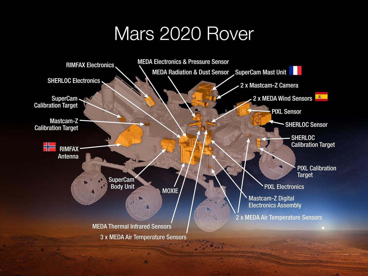
This 2015 diagram shows components of the investigations payload for NASA's Mars 2020 rover mission. Mars 2020 will re-use the basic engineering of NASA's Mars Science Laboratory to send a different rover to Mars, with new objectives and instruments, launching in 2020. The rover will carry seven instruments to conduct its science and exploration technology investigations. They are: Mastcam-Z, an advanced camera system with panoramic and stereoscopic imaging capability and the ability to zoom. The instrument also will determine mineralogy of the Martian surface and assist with rover operations. The principal investigator is James Bell, Arizona State University in Tempe. SuperCam, an instrument that can provide imaging, chemical composition analysis, and mineralogy. The instrument will also be able to detect the presence of organic compounds in rocks and regolith from a distance. The principal investigator is Roger Wiens, Los Alamos National Laboratory, Los Alamos, New Mexico. This instrument also has a significant contribution from the Centre National d'Etudes Spatiales, Institut de Recherche en Astrophysique et Planétologie (CNES/IRAP) France. Planetary Instrument for X-ray Lithochemistry (PIXL), an X-ray fluorescence spectrometer that will also contain an imager with high resolution to determine the fine-scale elemental composition of Martian surface materials. PIXL will provide capabilities that permit more detailed detection and analysis of chemical elements than ever before. The principal investigator is Abigail Allwood, NASA's Jet Propulsion Laboratory, Pasadena, California. Scanning Habitable Environments with Raman & Luminescence for Organics and Chemicals (SHERLOC), a spectrometer that will provide fine-scale imaging and uses an ultraviolet (UV) laser to determine fine-scale mineralogy and detect organic compounds. SHERLOC will be the first UV Raman spectrometer to fly to the surface of Mars and will provide complementary measurements with other instruments in the payload. SHERLOC includes a high-resolution color camera for microscopic imaging of Mars' surface. The principal investigator is Luther Beegle, JPL. The Mars Oxygen ISRU Experiment (MOXIE), an exploration technology investigation that will produce oxygen from Martian atmospheric carbon dioxide. The principal investigator is Michael Hecht, Massachusetts Institute of Technology, Cambridge, Massachusetts. Mars Environmental Dynamics Analyzer (MEDA), a set of sensors that will provide measurements of temperature, wind speed and direction, pressure, relative humidity and dust size and shape. The principal investigator is Jose Rodriguez-Manfredi, Centro de Astrobiologia, Instituto Nacional de Tecnica Aeroespacial, Spain. The Radar Imager for Mars' Subsurface Experiment (RIMFAX), a ground-penetrating radar that will provide centimeter-scale resolution of the geologic structure of the subsurface. The principal investigator is Svein-Erik Hamran, the Norwegian Defence Research Establishment, Norway. http://photojournal.jpl.nasa.gov/catalog/PIA19672
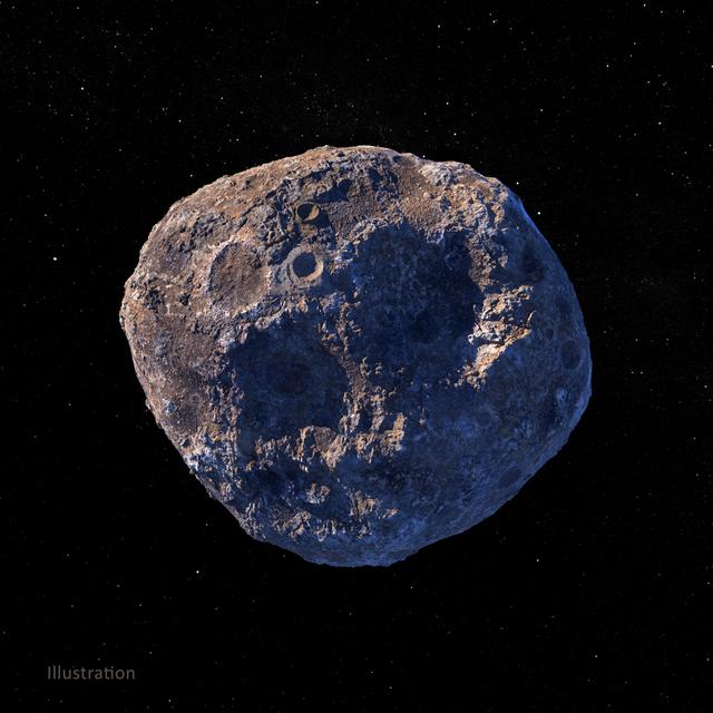
This illustration, created in March 2021, depicts the 140-mile-wide (226-kilometer-wide) asteroid Psyche, which lies in the main asteroid belt between Mars and Jupiter. Psyche is the focal point of NASA's mission of the same name. The Psyche spacecraft is set to launch in August 2022 and arrive at the asteroid in 2026, where it will orbit for 21 months and investigate its composition. Based on data obtained from Earth, scientists believe Psyche is a mixture of metal and rock. The rock and metal may be in large provinces, or areas, on the asteroid — as depicted in an illustration here: PIA24471. Another possibility is that rock and metal may be intimately mixed on a scale too small to detect from orbit — as depicted in the illustration above. Observing and measuring how the metal and rock are mixed will help scientists determine how Psyche formed. Exploring the asteroid could also give valuable insight into how our own planet and others formed. The Psyche team will use a magnetometer to measure the asteroid's magnetic field. A multispectral imager will capture images of the surface, as well as data about the Psyche's composition and topography. Spectrometers will analyze the neutrons and gamma rays coming from the surface to reveal the elements that make up the asteroid itself. The image was created by Peter Rubin. https://photojournal.jpl.nasa.gov/catalog/PIA24472
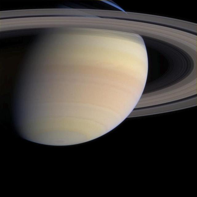
As Cassini coasts into the final month of its nearly seven-year trek, the serene majesty of its destination looms ahead. The spacecraft's cameras are functioning beautifully and continue to return stunning views from Cassini's position, 1.2 billion kilometers (750 million miles) from Earth and now 15.7 million kilometers (9.8 million miles) from Saturn. In this narrow angle camera image from May 21, 2004, the ringed planet displays subtle, multi-hued atmospheric bands, colored by yet undetermined compounds. Cassini mission scientists hope to determine the exact composition of this material. This image also offers a preview of the detailed survey Cassini will conduct on the planet's dazzling rings. Slight differences in color denote both differences in ring particle composition and light scattering properties. Images taken through blue, green and red filters were combined to create this natural color view. The image scale is 132 kilometers (82 miles) per pixel. http://photojournal.jpl.nasa.gov/catalog/PIA06060
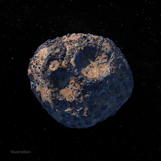
This illustration, created in March 2021, depicts the 140-mile-wide (226-kilometer-wide) asteroid Psyche, which lies in the main asteroid belt between Mars and Jupiter. Psyche is the focal point of NASA's mission of the same name. The Psyche spacecraft is set to launch in August 2022 and arrive at the asteroid in 2026, where it will orbit for 21 months and investigate its composition. Based on data obtained from Earth, scientists believe Psyche is a mixture of metal and rock. The rock and metal may be in large provinces, or areas, on the asteroid — as illustrated in this rendering. Another possibility is that rock and metal may be intimately mixed on a scale too small to detect from orbit — as depicted in an illustration here: PIA24472. Observing and measuring how the metal and rock are mixed will help scientists determine how Psyche formed. Exploring the asteroid could also give valuable insight into how our own planet and others formed. The Psyche team will use a magnetometer to measure the asteroid's magnetic field. A multispectral imager will capture images of the surface, as well as data about the Psyche's composition and topography. Spectrometers will analyze the neutrons and gamma rays coming from the surface to reveal the elements that make up the asteroid itself. The image was created by Peter Rubin. https://photojournal.jpl.nasa.gov/catalog/PIA24471
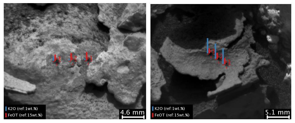
These images and overlay bar charts from the Chemistry and Camera (ChemCam) instrument on NASA's Curiosity Mars rover indicate where some high-potassium material is localized within mineral veins at "Garden City." The two images are from ChemCam's Remote Micro-Imager. Each covers an area just over an inch wide (scale bars are in millimeters) in veins at the Garden City site on lower Mount Sharp. The overlay charts show comparisons of potassium (blue) and iron (red) in the mineral veins' compositions determined by reading the spectra of light induced by zapping points in each area with ChemCam's laser. Mineral veins such as these form where fluids move through fractured rocks, depositing minerals in the fractures and affecting chemistry of the surrounding rock. The thin layer of dark fracture-filling material in the image on the right contains much more potassium than the other local material on the left, indicating either different fluid compositions or local variations in the rock. The image on the left was taken on April 4, 2015, during the 946th Martian day, or sol, of Curiosity's work on Mars. The image on the right was taken on Sol 936, on March 25, 2015. A broader view of the prominent mineral veins at Garden City is at PIA19161. http://photojournal.jpl.nasa.gov/catalog/PIA19923
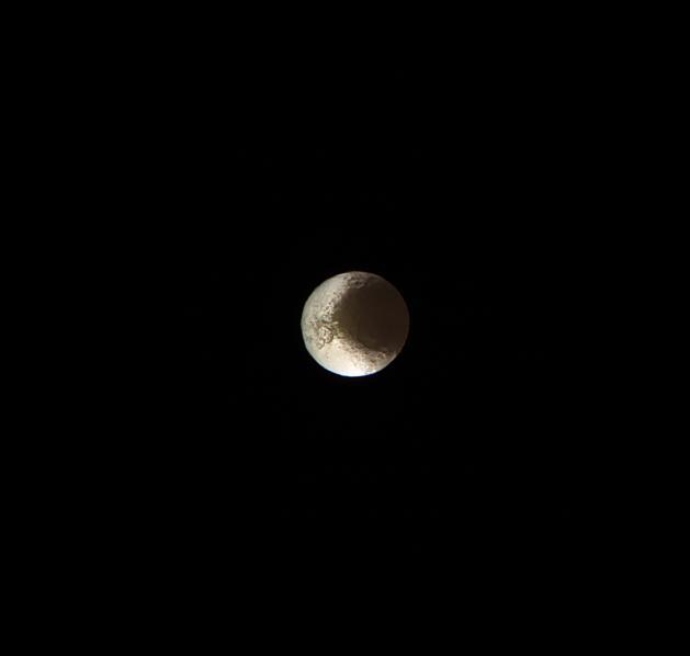
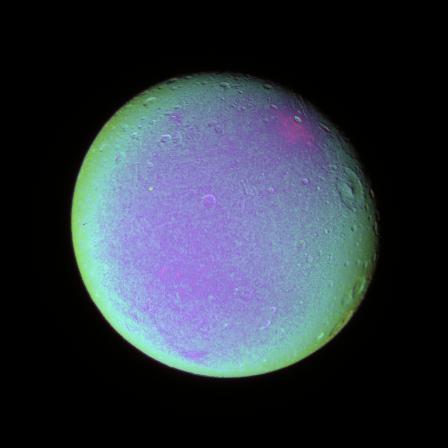
Cassini bids farewell to Saturn's yin-and-yang moon, Iapetus. This image is from the last set of observations Cassini made of this world of striking contrasts. The spacecraft helped scientists better understand Iapetus, solving a centuries-old mystery of why it should be bright on one side and dark on the other. Cassini observations of Iapetus (914 mile or 1471 kilometers across) support the prevailing theory that led to the understanding that the dichotomy of the surface is due to a combination of infalling dust from outside of the moon followed by a migration of water ice from the darker (therefore warmer) areas to the cold, brighter surfaces. See PIA11690 for more details. This false-color view is a composite of individual frames obtained using filters sensitive to ultraviolet (centered at 338 nanometers), green (centered at 568 nanometers) and infrared light (centered at 930 nanometers). The view has been enhanced to accentuate subtle color differences and fine-scale surface features. This view looks toward the Saturn-facing hemisphere of Iapetus. North on Iapetus is up and rotated 12 degrees to the left. The view was acquired on May 30, 2017, at a distance of approximately 1.5 million miles (2.5 million kilometers) from Iapetus. Image scale is 9 miles (15 kilometers) per pixel. https://photojournal.jpl.nasa.gov/catalog/PIA21347
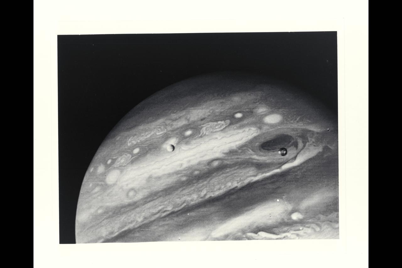
Voyager 1 Image of Jupiter and two of its satellites (Io, left, and Europa). Io is about 350,000 kilometers (220,000 miles) above Jupiter's Great Red Spot; Europa is about 600,000 kilometers (375,000 miles) above Jupiter's clouds. Although both satellites have about the same brightness, Io's color is very different from Europa's. Io's equatorial region show two types of material -- dark orange, broken by several bright spots -- producing a mottled appearance. The poles are darker and reddish. Preliminary evidence suggests color variations within and between the polar regions. Io's surface composition is unknown, but scientists believe it may be a mixture of salts and sulfur. Erupoa is less strongly colored, although still relatively dark at short wavelengths. Markings on Eruopa are less evident that on the other satellites, although this picture shows darker regions toward the trailing half of the visible disk. Jupiter at this point is about 20 million kilometers (12.4 million miles) from the spacecraft. At this resolution (about 400 kimometers or 250 miles) there is evidence of circular motion in Jupiter's atmosphere. While the dominant large-scale motions are west-to-east, small-scale movement includes eddy-like circulation within and between the bands. (JPL ref: P-21082)
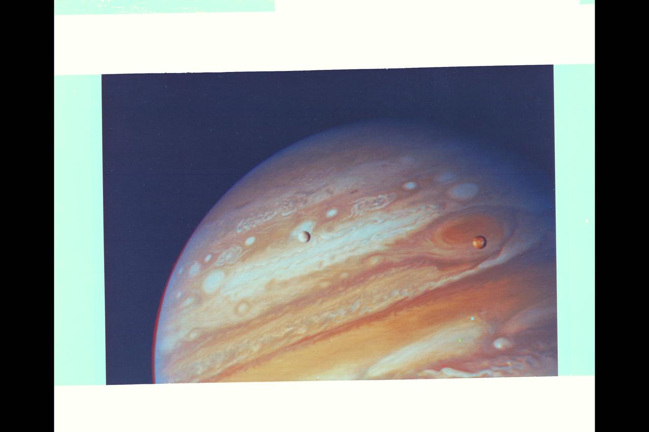
Voyager 1 Image of Jupiter and two of its satellites (Io, left, and Europa). Io is about 350,000 kilometers (220,000 miles) above Jupiter's Great Red Spot; Europa is about 600,000 kilometers (375,000 miles) above Jupiter's clouds. Although both satellites have about the same brightness, Io's color is very different from Europa's. Io's equatorial region show two types of material -- dark orange, broken by several bright spots -- producing a mottled appearance. The poles are darker and reddish. Preliminary evidence suggests color variations within and between the polar regions. Io's surface composition is unknown, but scientists believe it may be a mixture of salts and sulfur. Erupoa is less strongly colored, although still relatively dark at short wavelengths. Markings on Eruopa are less evident that on the other satellites, although this picture shows darker regions toward the trailing half of the visible disk. Jupiter at this point is about 20 million kilometers (12.4 million miles) from the spacecraft. At this resolution (about 400 kimometers or 250 miles) there is evidence of circular motion in Jupiter's atmosphere. While the dominant large-scale motions are west-to-east, small-scale movement includes eddy-like circulation within and between the bands. (JPL ref: P-21082)

This scale model depicts the Materials Science Research Rack-1 (MSRR-1) being developed by NASA's Marshall Space Flight Center and the European Space Agency (ESA) for placement in the Destiny laboratory module aboard the International Space Station. The rack is part of the plarned Materials Science Research Facility (MSRF) and is expected to include two furnace module inserts, a Quench Module Insert (being developed by NASA's Marshall Space Flight Center) to study directional solidification in rapidly cooled alloys and a Diffusion Module Insert (being developed by the European Space Agency) to study crystal growth, and a transparent furnace (being developed by NASA's Space Product Development program). Multi-user equipment in the rack is being developed under the auspices of NASA's Office of Biological and Physical Research (OBPR) and ESA. Key elements are labeled in other images (0101754, 0101829, and TBD). This composite is from a digital still camera; higher resolution is not available.

KENNEDY SPACE CENTER, FLA. - (From left, backs to the camera) Pilot Steve Fossett, Sir Richard Branson and Jon Karkow talk with the media about the reason the takeoff of the Virgin Atlantic GlobalFlyer was postponed. Branson is chairman and founder of Virgin Atlantic. Karkow, with Scaled Composites, is chief engineer for the GlobalFlyer. Fossett will pilot the GlobalFlyer on a record-breaking attempt by flying solo, non-stop without refueling, to surpass the current record for the longest flight of any aircraft. Fossett was expected to take off from the KSC SLF before the takeoff was postponed due to the fuel leak that appeared in the last moments of loading. The next planned takeoff attempt is 7 a.m. Feb. 8 from the SLF. Photo credit: NASA/Kim Shiflett

From its vantage point aboard the International Space Station (ISS), NASA's Earth Surface Mineral Dust Source Investigation (EMIT) mission will map the world's mineral-dust sources, gathering information about particle color and composition as the instrument, designed at NASA's Jet Propulsion Laboratory in Southern California, orbits over the planet's dry, sparsely vegetated regions. EMIT will collect measurements of 10 important surface minerals – hematite, goethite, illite, vermiculite, calcite, dolomite, montmorillonite, kaolinite, chlorite, and gypsum – in arid regions between 50-degree south and north latitudes in Africa, Asia, North and South America, and Australia. The data EMIT collects will help scientists better understand the role of airborne dust particles in heating and cooling Earth's atmosphere on global and regional scales. https://photojournal.jpl.nasa.gov/catalog/PIA25145

KENNEDY SPACE CENTER, FLA. - Pilot Steve Fossett (far right), Sir Richard Branson (center) and Jon Karkow (far left) talk to the media about the reason the takeoff of the Virgin Atlantic GlobalFlyer was postponed. Branson is chairman and founder of Virgin Atlantic. Karkow, with Scaled Composites, is chief engineer for the GlobalFlyer. Fossett will pilot the GlobalFlyer on a record-breaking attempt by flying solo, non-stop without refueling, to surpass the current record for the longest flight of any aircraft. Fossett was expected to take off from the KSC SLF before the takeoff was postponed due to the fuel leak that appeared in the last moments of loading. The next planned takeoff attempt is 7 a.m. Feb. 8 from the SLF. Photo credit: NASA/Kim Shiflett
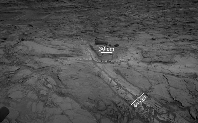
Pale zones called "halos" border bedrock fractures visible in this 2015 image from NASA's Curiosity Mars rover which has been darkened (a previously released image can be seen at PIA20268). Measurements overlaid on the image offer a sense of scale for the size of these fractures. The rover team determined that the halos are rich in silica, a clue to the duration of wet environmental conditions long ago. The location is on the lower slope of Mars' Mount Sharp. Curiosity's Navigation Camera (Navcam) acquired the component images of this mosaic on Aug. 23, 2015, during the 1.083rd Martian day, or sol, of the mission. The location is along the rover's path between "Marias Pass" and "Bridger Basin." In this region, the rover has found fracture zones to be associated with rock compositions enriched in silica, relative to surrounding bedrock. https://photojournal.jpl.nasa.gov/catalog/PIA21649
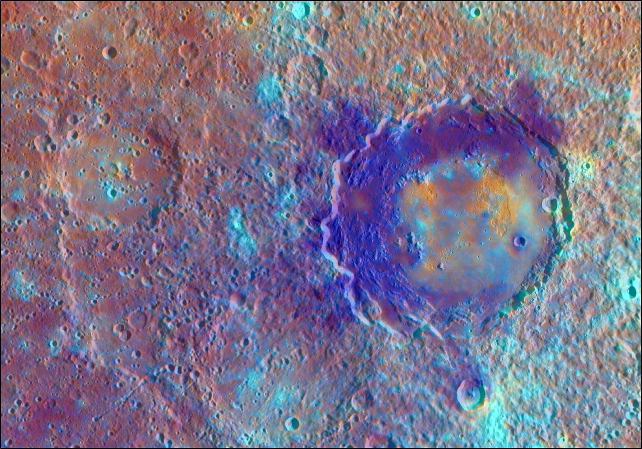
In this enhanced color view from NASA MESSENGER spacecraft of the peak-ring basin Derain, the different colors accentuate the different rocks associated with the basin. The smooth, interior volcanic fill of the basin, in addition to the large pits on the floor of Derain, are brighter and redder. This view was created by draping a color composite from the MDIS Wide Angle Camera (WAC) over an MDIS monochrome Narrow Angle Camera (NAC) image mosaic. The WAC enhanced color image was created with the following image channels: red = Principal Component 2, green = Principal Component 1, and blue = 430 nm to 1000 nm band ratio. Instrument: Mercury Dual Imaging System (MDIS) Latitude: -9.0° Longitude: 17.3° E Scale: Derain peak-ring basin has a diameter of 167 km (104 miles) http://photojournal.jpl.nasa.gov/catalog/PIA19412

Scientists believe that under the icy surface of Jupiter's moon Europa a saltwater ocean exists that may contain more than twice as much liquid water as all of Earth's oceans combined. This artist's concept (not to scale) depicts what Europa's internal structure could look like: an outer shell of ice, perhaps with plumes of material venting from beneath the surface; a deep, global layer of liquid water; and a rocky interior, potentially with hydrothermal vents on the seafloor. The true nature of Europa's inner structure will be examined by NASA's Europa Clipper mission, which is scheduled to arrive at Jupiter in 2030. Europa Clipper's three main science objectives are to determine the thickness of the moon's icy shell and its interactions with the ocean below, to investigate its composition, and to characterize its geology. The mission's detailed exploration of Europa will help scientists better understand the astrobiological potential for habitable worlds beyond our planet. https://photojournal.jpl.nasa.gov/catalog/PIA26438
P-34668 Range : 2.8 million km. ( 1.7 million miles ) Smallest Resolvable Feature : 50 km or 31 miles This Voyager 2 image shows the last face on view of the Great Dark Spot that Voyager 2 will take with the narrow angle camera. It was made 45 hours before the closest approach to Neptune. the image shows feathery white clouds that overlie the boundary of the dark and light blue regions. the pinwheel ( spiral ) structure of both the dark boundary and the white cirrus suggest a storm system rotating counterclockwise. Periodic, small-scale patterns in the white clouds, possibly waves, are short-lived and do not persist from one Neptunian rotation to the next. This color composite was made from the clear and green filter images.
The leading hemisphere of Dione displays subtle variations in color across its surface in this false color view. To create this view, ultraviolet, green and infrared images were combined into a single black and white picture that isolates and maps regional color differences. This "color map" was then superposed over a clear-filter image. The origin of the color differences is not yet understood, but may be caused by subtle differences in the surface composition or the sizes of grains making up the icy soil. Terrain visible here is on the moon's leading hemisphere. North on Dione (1,126 kilometers, or 700 miles across) is up and rotated 17 degrees to the right. All images were acquired with the Cassini spacecraft narrow-angle camera on Dec. 24, 2005 at a distance of approximately 597,000 kilometers (371,000 miles) from Dione and at a Sun-Dione-spacecraft, or phase, angle of 21 degrees. Image scale is 4 kilometers (2 miles) per pixel. http://photojournal.jpl.nasa.gov/catalog/PIA07688

This photograph shows the last face on view of the Great Dark Spot that Voyager will make with the narrow angle camera. The image was shuttered 45 hours before closest approach at a distance of 2.8 million kilometers (1.7 million miles). The smallest structures that can be seen are of an order of 50 kilometers (31 miles). The image shows feathery white clouds that overlie the boundary of the dark and light blue regions. The pinwheel (spiral) structure of both the dark boundary and the white cirrus suggest a storm system rotating counterclockwise. Periodic small scale patterns in the white cloud, possibly waves, are short lived and do not persist from one Neptunian rotation to the next. This color composite was made from the clear and green filters of the narrow-angle camera. http://photojournal.jpl.nasa.gov/catalog/PIA00052
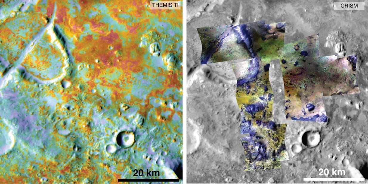
Researchers estimating the amount of carbon held in the ground at the largest known carbonate-containing deposit on Mars utilized data from three different NASA Mars orbiters. Each image in this pair covers the same area about 36 miles (58 kilometers) wide in the Nili Fossae plains region of Mars' northern hemisphere. The tally of carbon content in the rocks of this region is a key piece in solving a puzzle of how the Martian atmosphere has changed over time. Carbon dioxide from the atmosphere on early Mars reacted with surface rocks to form carbonate, thinning the atmosphere. The image on the left presents data from the Thermal Emission Imaging System (THEMIS) instrument on NASA's Mars Odyssey orbiter. The color coding indicates thermal inertia -- the property of how quickly a surface material heats up or cools off. Sand, for example (blue hues), cools off quicker after sundown than bedrock (red hues) does. The color coding in the image on the right presents data from the Compact Reconnaissance Imaging Spectrometer for Mars (CRISM) instrument on NASA's Mars Reconnaissance Orbiter. From the brightness at many different wavelengths, CRISM data can indicate what minerals are present on the surface. In the color coding used here, green hues are consistent with carbonate-bearing materials, while brown or yellow hues are olivine-bearing sands and locations with purple hues are basaltic in composition. The gray scale base map is a mosaic of daytime THEMIS infrared images. Annotations point to areas with different surface compositions. The scale bar indicates 20 kilometers (12.4 miles). http://photojournal.jpl.nasa.gov/catalog/PIA19816
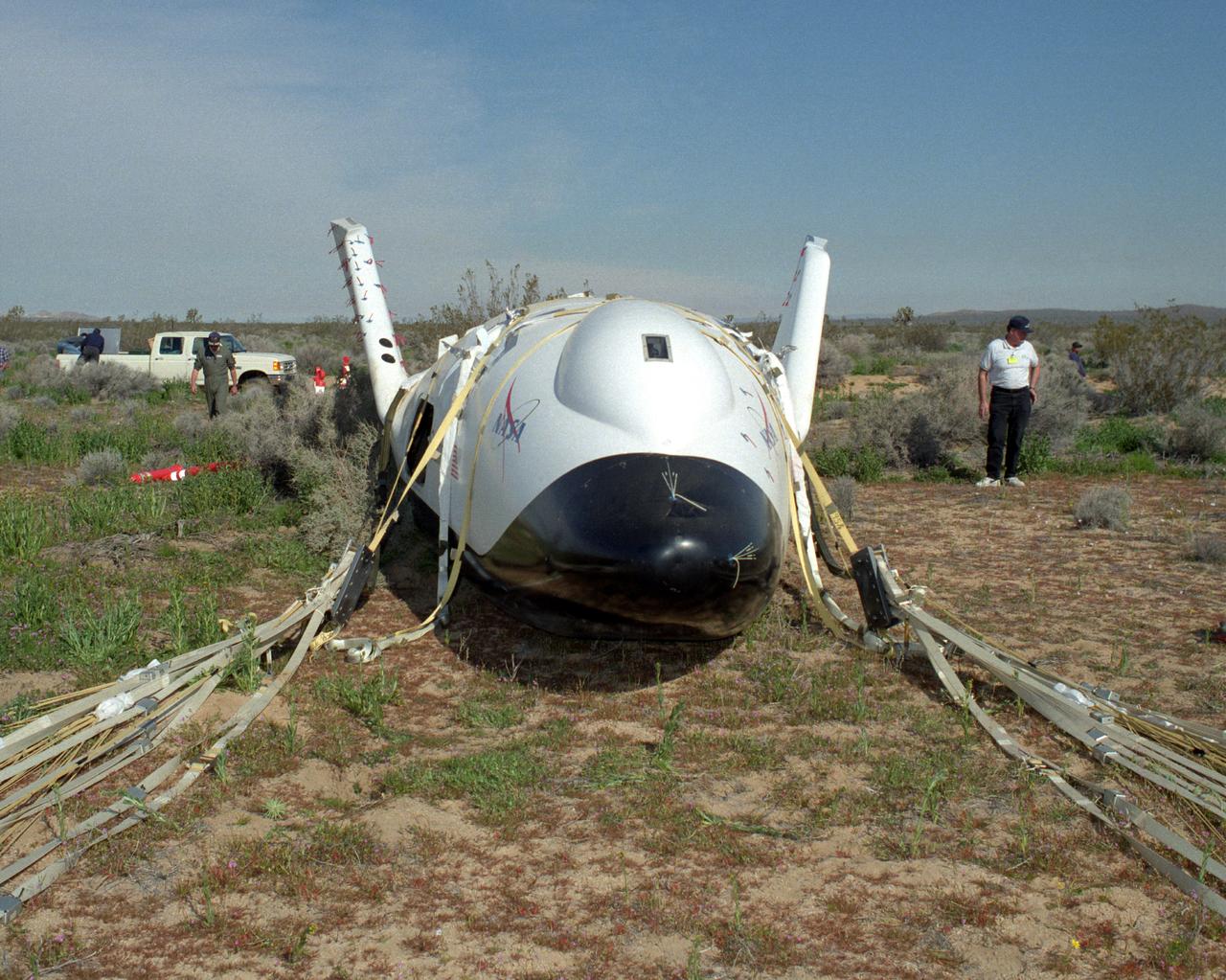
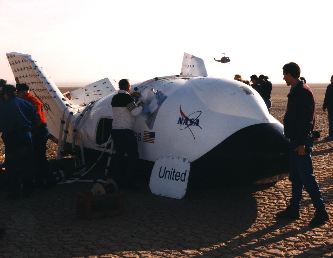
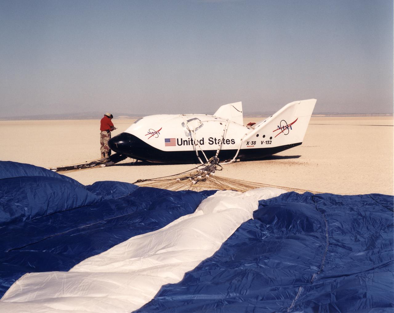
The X-38 Crew Return Vehicle touches down amidst the California desert scrubbrush at the end of its first free flight at the Dryden Flight Research Center, Edwards, California, in March 1998.
The X-38, a research vehicle built to help develop technology for an emergency Crew Return Vehicle from the International Space Station, is seen just before touchdown on a lakebed near the Dryden Flight Research Center, Edwards California, at the end of a March 2000 test flight.
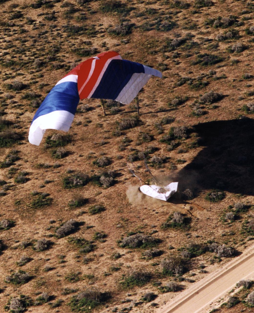
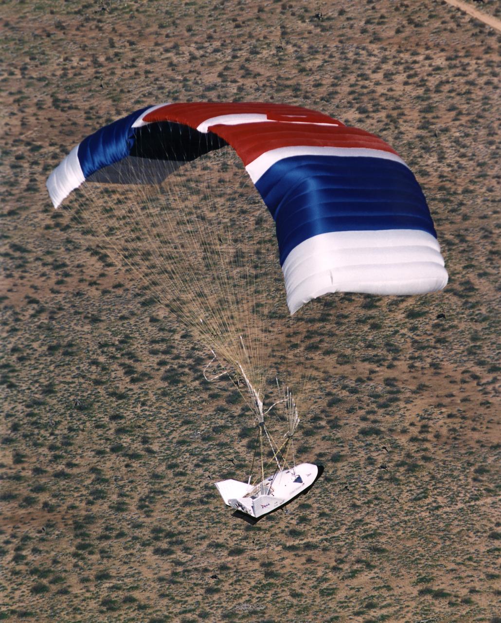
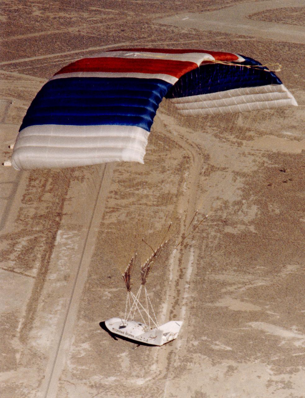
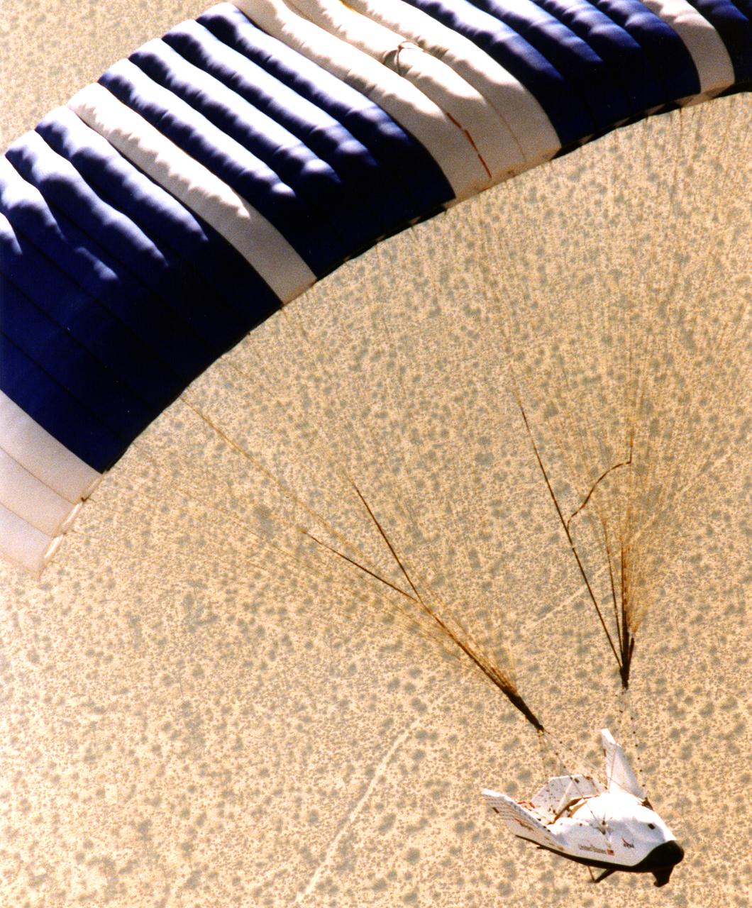
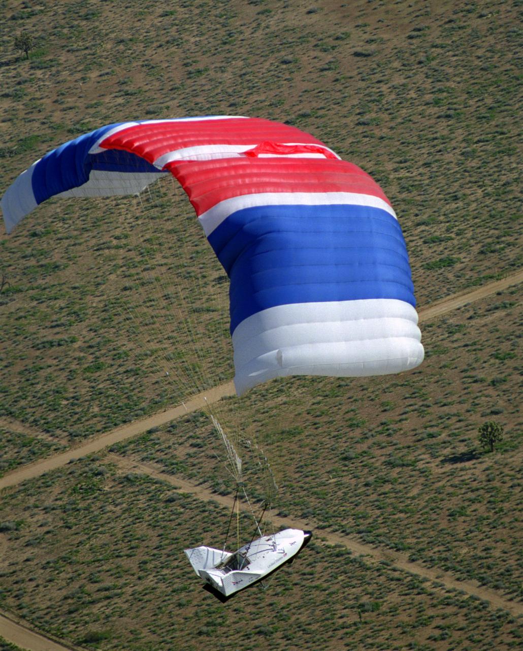
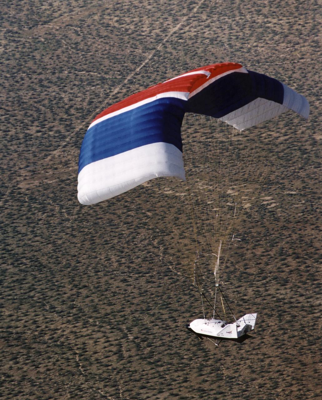
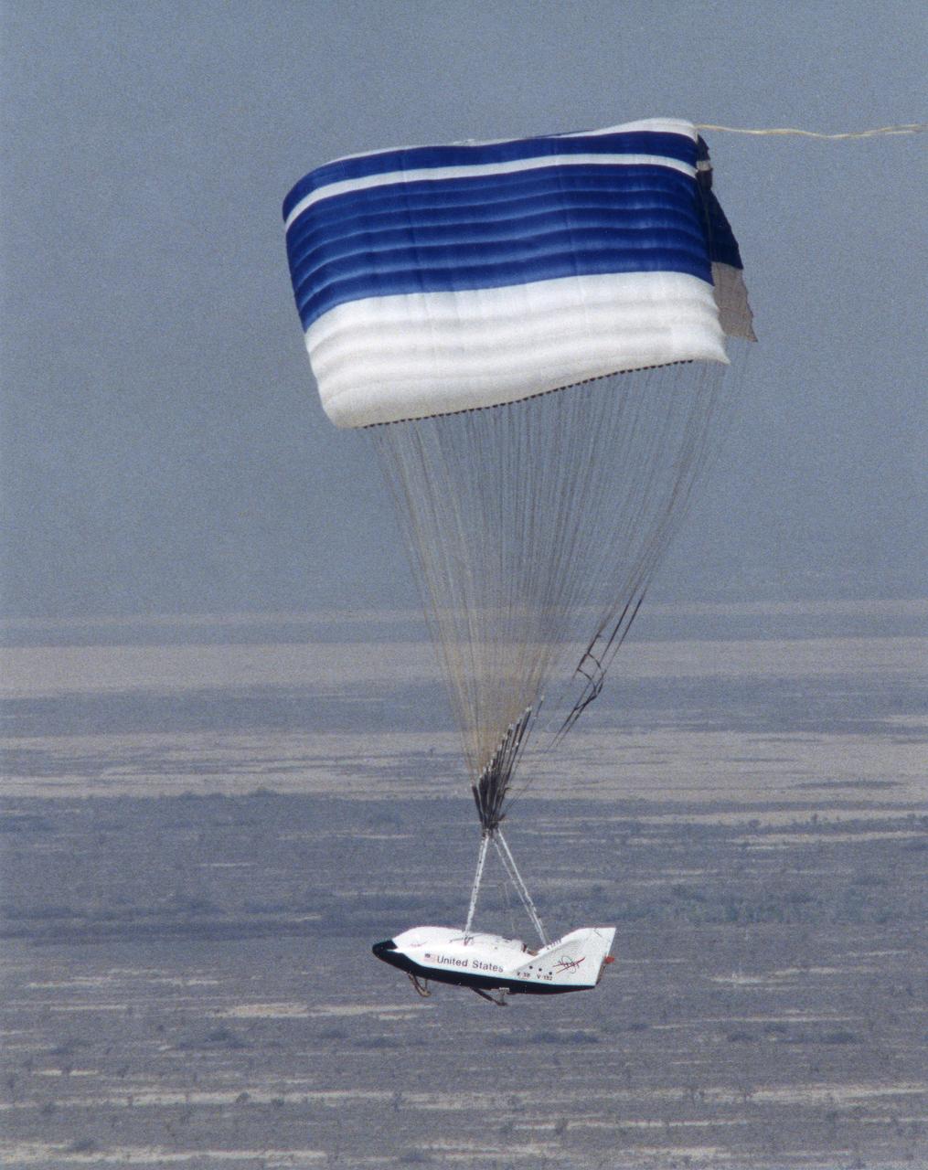
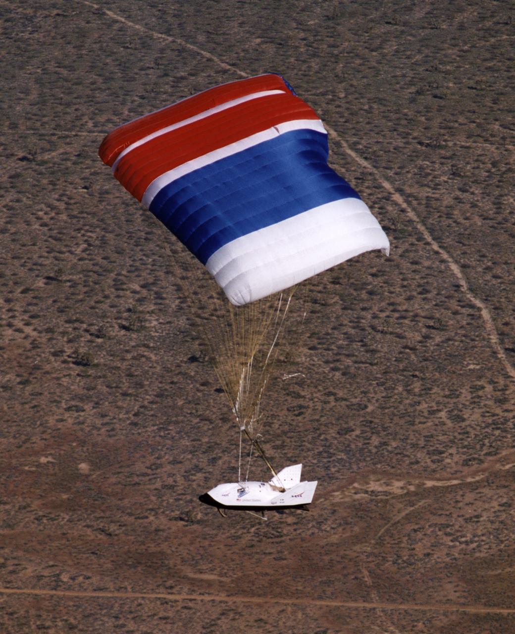
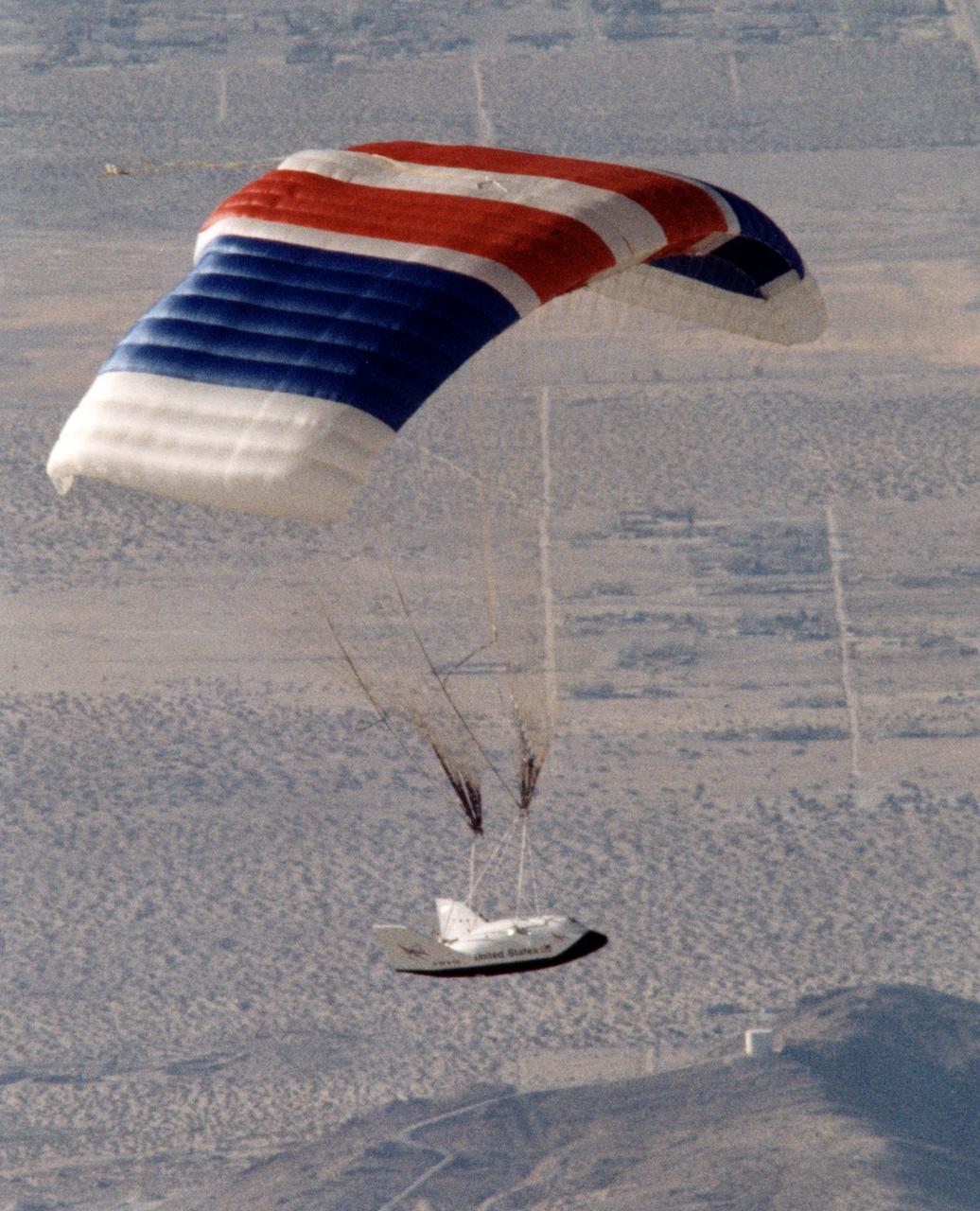
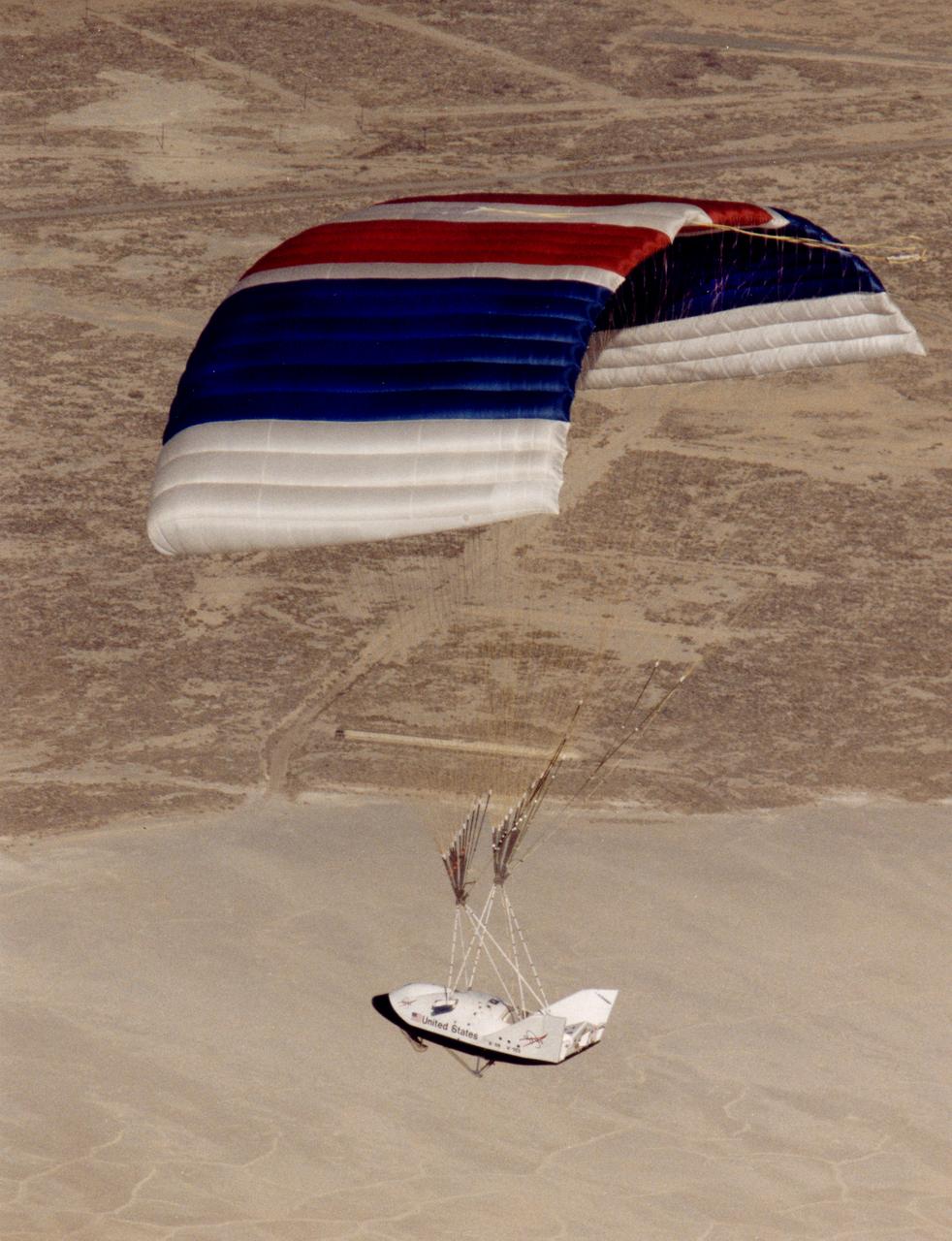
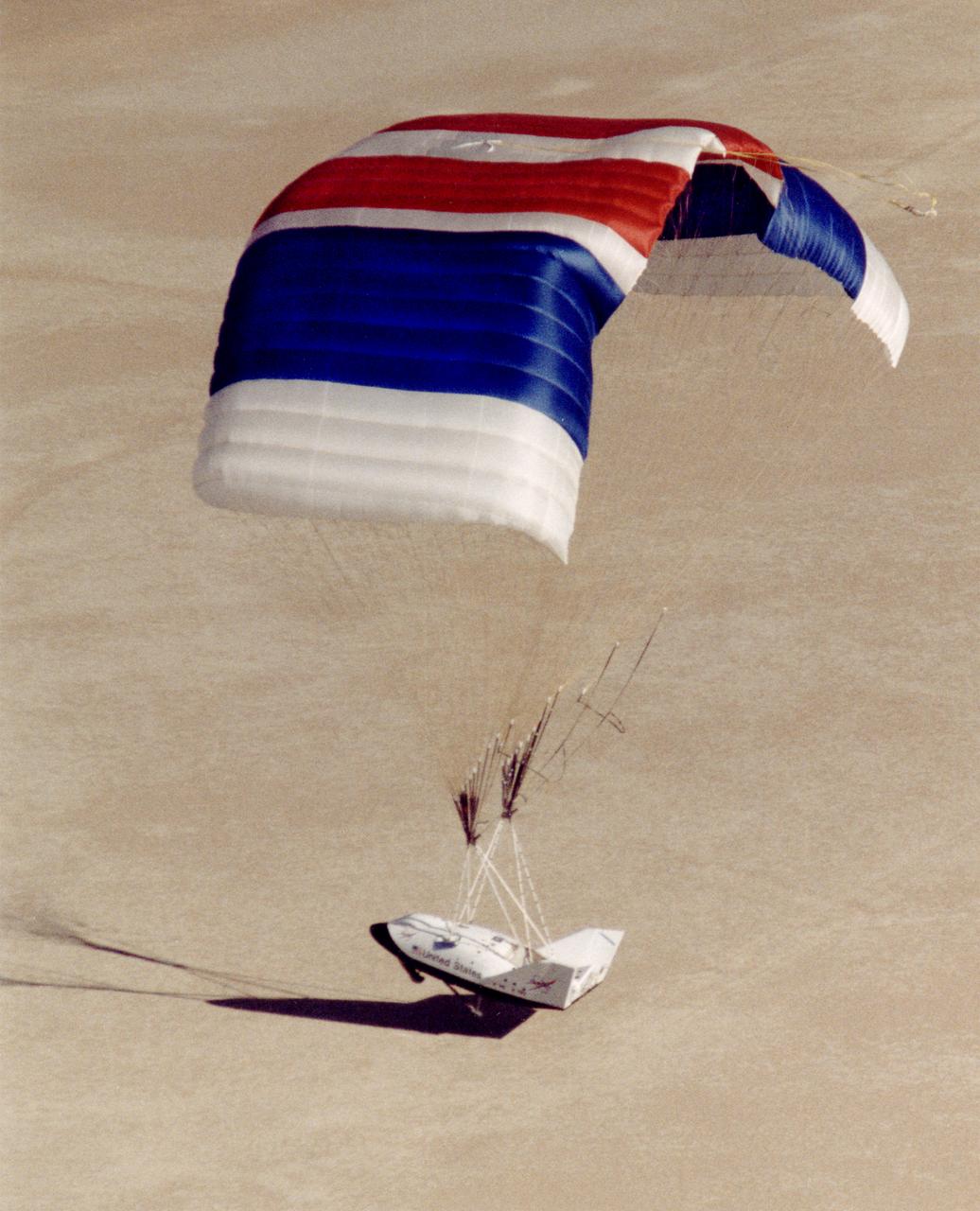
The X-38 prototypes are intended to perfect a "crew lifeboat" for the International Space Station. The X-38 vehicle 131R demonstrates a huge 7,500 square-foot parafoil that will that will enable the Crew Return Vehicle (CRV) to land on the length of a football field after returning from space. The CRV is intended to serve as an emergency transport to carry a crew to safety in the event of problems with the International Space Station.
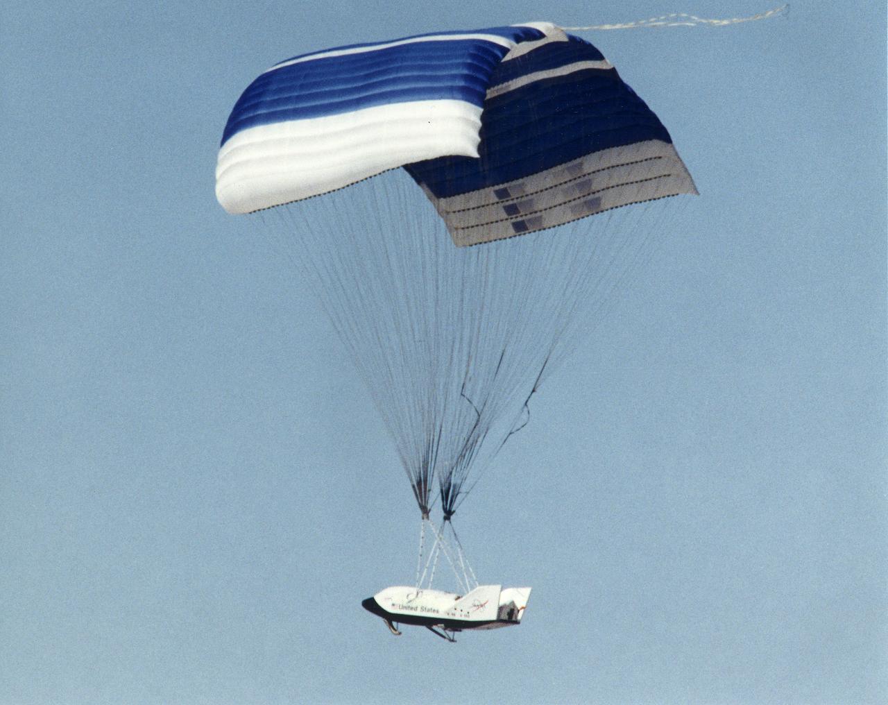
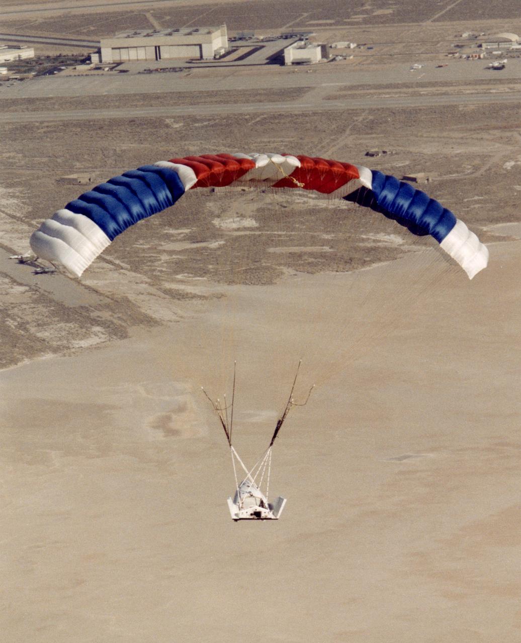
The X-38 Crew Return Vehicle descends under its steerable parafoil over the California desert in its first free flight at the Dryden Flight Research Center, Edwards, California. The flight took place March 12, 1998.
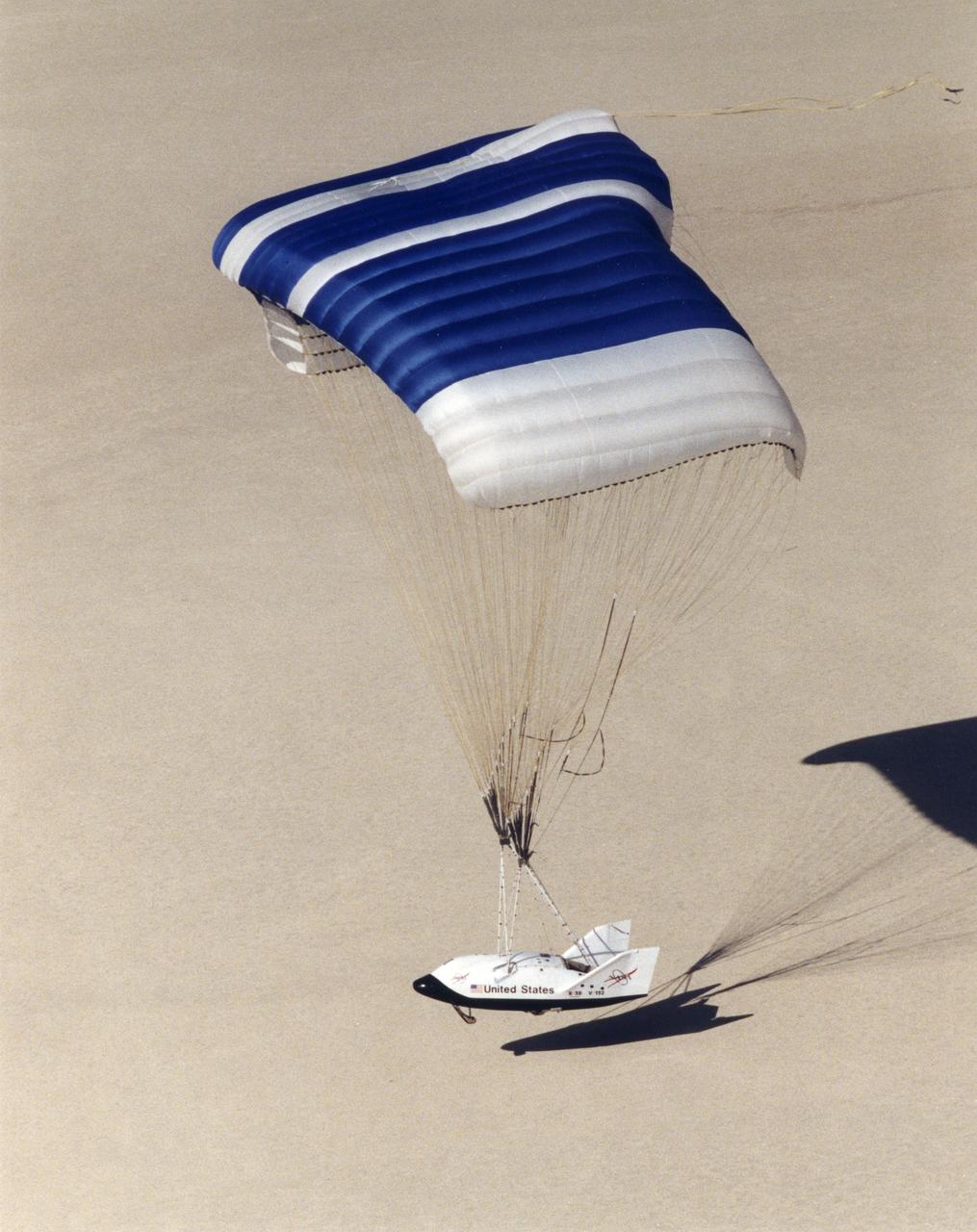
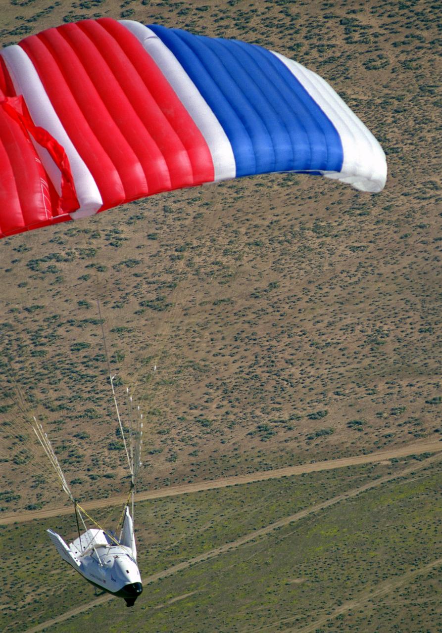
NASA's X-38, a research vehicle developed as part of an effort to build an emergency Crew Return Vehicle (CRV) for the International Space Station, descends toward the desert floor under its steerable parafoil on its second free flight. The X-38 was launched from NASA Dryden's B-52 Mothership on Saturday, February 6, 1999, from an altitude of approximately 23,000 feet.
The X-38, a research vehicle built to help develop technology for an emergency Crew Return Vehicle (CRV), descends under its steerable parafoil on a March 1999 test flight at the Dryden Flight Research Center, Edwards, California.
NASA's X-38, a research vehicle developed as part of an effort to build an emergency Crew Return Vehicle (CRV) for the International Space Station, descends toward the desert floor under its steerable parafoil on its second free flight. The X-38 was launched from NASA Dryden's B-52 Mothership on Saturday, February 6, 1999, from an altitude of approximately 23,000 feet.
The X-38 Crew Return Vehicle descends under its steerable parafoil over the California desert in its first free flight at the Dryden Flight Research Center, Edwards, California. The flight took place March 12, 1998.
The X-38 Crew Return Vehicle descends under its steerable parafoil over the California desert in its first free flight at the Dryden Flight Research Center, Edwards, California. The flight took place March 12, 1998.
Crew members surround the X-38 lifting body research vehicle after a successful test flight and landing in March 1998. The flight was the first free flight for the vehicle and took place at the Dryden Flight Research Center, Edwards, California.
The X-38 technology demonstrator descends under its steerable parafoil toward a lakebed landing in a March 2000 test flight.
The X-38 Crew Return Vehicle descends under its steerable parafoil over the California desert during its first free flight in March 1998 at the Dryden Flight Research Center, Edwards, California.
The X-38 technology demonstrator descends under its steerable parafoil toward a lakebed landing in a March 2000 test flight.

The latest version of the X-38, V-131R, touches down on Rogers Dry Lake adjacent to NASAÕs Dryden Flight Research Center at Edwards, California, at the end of its first free flight under a giant parafoil on Nov. 2, 2000. The X-38 prototypes are intended to perfect technology for a planned Crew Return Vehicle (CRV) ÒlifeboatÓ to carry a crew to safety in the event of an emergency on the International Space Station. Free-flight tests of X-38 V-131R are evaluating upgraded avionics and control systems and the aerodynamics of the modified upper body, which is more representative of the final design of the CRV than the two earlier X-38 test craft, including a simulated hatch atop the body. The huge 7,500 square-foot parafoil will enable the CRV to land in the length of a football field after returning from space. The first three X-38Õs are air-launched from NASAÕs venerable NB-52B mother ship, while the last version, V-201, will be carried into space by a Space Shuttle and make a fully autonomous re-entry and landing.

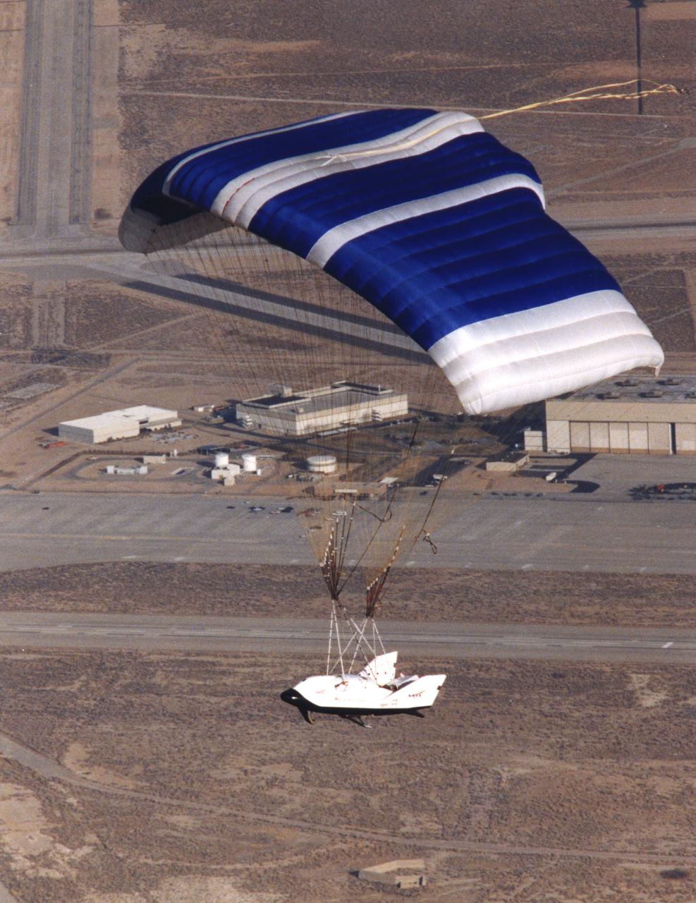
The X-38, a research vehicle built to help develop technology for an emergency Crew Return Vehicle (CRV), descends under its steerable parachute during a July 1999 test flight at the Dryden Flight Research Center, Edwards, California. It was the fourth free flight of the test vehicles in the X-38 program, and the second free flight test of Vehicle 132 or Ship 2. The goal of this flight was to release the vehicle from a higher altitude -- 31,500 feet -- and to fly the vehicle longer -- 31 seconds -- than any previous X-38 vehicle had yet flown. The project team also conducted aerodynamic verification maneuvers and checked improvements made to the drogue parachute.
NASA's X-38, a prototype of a Crew Return Vehicle (CRV) resting on the lakebed near the Dryden Flight Research Center after the completion of its second free flight. The X-38 was launched from NASA Dryden's B-52 Mothership on Saturday, February 6, 1999, from an altitude of approximately 23,000 feet.

Dale Reed, a NASA engineer who worked on the original lifting-body research programs in the 1960s and 1970s, stands with a scale-model X-38 that was used in 1995 research flights, with a full-scale X-38 (80 percent of the size of a potential Crew Return Vehicle) behind him.
The X-38, a research vehicle built to help develop technology for an emergency Crew Return Vehicle (CRV), maneuvers toward landing at the end of a March 1999 test flight at the Dryden Flight Research Center, Edwards, California.
The X-38 Crew Return Vehicle descends under its steerable parafoil over the California desert in its first free flight at the Dryden Flight Research Center, Edwards, California. The flight took place March 12, 1998.
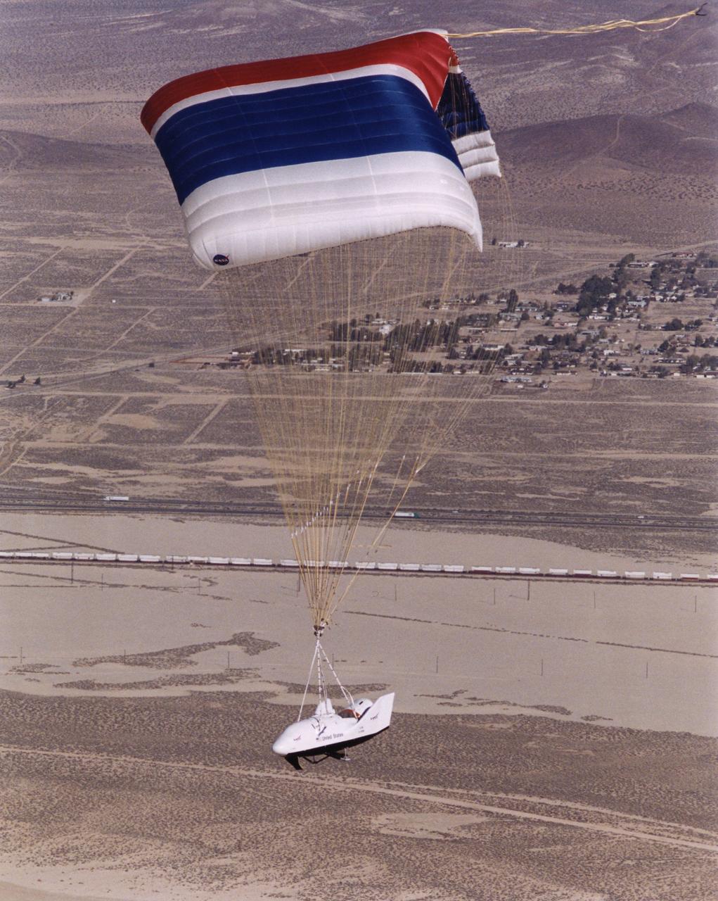
The third iteration of the X-38, V-131R, glides down under a giant parafoil towards a landing on Rogers Dry Lake near NASAÕs Dryden Flight Research Center during its first free flight Nov. 2, 2000. The X-38 prototypes are intended to perfect technology for a planned Crew Return Vehicle (CRV) ÒlifeboatÓ to carry a crew to safety in the event of an emergency on the International Space Station. Free-flight tests of X-38 V-131R are evaluating upgraded avionics and control systems and the aerodynamics of the modified upper body, which is more representative of the final design of the CRV than the two earlier X-38 test craft, including a simulated hatch atop the body. The huge 7,500 square-foot parafoil will enable the CRV to land in the length of a football field after returning from space. The first three X-38Õs are air-launched from NASAÕs venerable NB-52B mother ship, while the last version, V-201, will be carried into space by a Space Shuttle and make a fully autonomous re-entry and landing.
The X-38, a research vehicle built to help develop technology for an emergency Crew Return Vehicle (CRV), descends under its steerable parafoil on a March 1999 test flight at the Dryden Flight Research Center, Edwards, California.
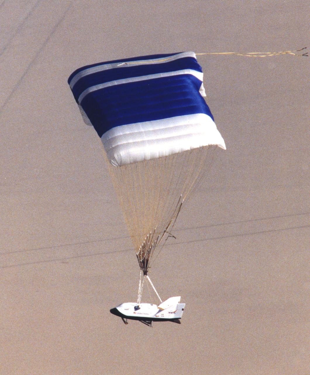
The X-38's blue and white parafoil spreads out in front of the research vehicle as it sits on a lakebed near the Dryden Flight Research Center after a March 2000 test flight.
The X-38, a research vehicle built to help develop technology for an emergency Crew Return Vehicle (CRV), descends under its steerable parafoil on a March 1999 test flight at the Dryden Flight Research Center, Edwards, California.
NASA's X-38, a research vehicle developed as part of an effort to build an emergency Crew Return Vehicle (CRV) for the International Space Station, descends toward a desert lakebed under its steerable parafoil on its second free flight. The X-38 was launched from NASA Dryden's B-52 Mothership on Saturday, February 6, 1999, from an altitude of approximately 23,000 feet.
The X-38, a research vehicle built to help develop technology for an emergency Crew Return Vehicle (CRV), flares for its lakebed landing at the end of a March 1999 test flight at the Dryden Flight Research Center, Edwards, California.
This view combines information from two instruments on NASA's Mars Reconnaissance Orbiter to map color-coded composition over the shape of the ground in a small portion of the Nili Fossae plains region of Mars' northern hemisphere. This site is part of the largest known carbonate-rich deposit on Mars. In the color coding used for this map, green indicates a carbonate-rich composition, brown indicates olivine-rich sands, and purple indicates basaltic composition. Carbon dioxide from the atmosphere on early Mars reacted with surface rocks to form carbonate, thinning the atmosphere by sequestering the carbon in the rocks. An analysis of the amount of carbon contained in Nili Fossae plains estimated the total at no more than twice the amount of carbon in the modern atmosphere of Mars, which is mostly carbon dioxide. That is much more than in all other known carbonate on Mars, but far short of enough to explain how Mars could have had a thick enough atmosphere to keep surface water from freezing during a period when rivers were cutting extensive valley networks on the Red Planet. Other possible explanations for the change from an era with rivers to dry modern Mars are being investigated. This image covers an area approximately 1.4 miles (2.3 kilometers) wide. A scale bar indicates 500 meters (1,640 feet). The full extent of the carbonate-containing deposit in the region is at least as large as Delaware and perhaps as large as Arizona. The color coding is from data acquired by the Compact Reconnaissance Imaging Spectrometer for Mars (CRISM), in observation FRT0000C968 made on Sept. 19, 2008. The base map showing land shapes is from the High Resolution Imaging Science Experiment (HiRISE) camera. It is one product from HiRISE observation ESP_010351_2020, made July 20, 2013. http://photojournal.jpl.nasa.gov/catalog/PIA19817
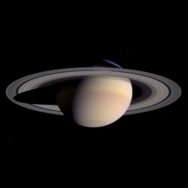
Saturn and its rings completely fill the field of view of Cassini's narrow angle camera in this natural color image taken on March 27, 2004. This is the last single 'eyeful' of Saturn and its rings achievable with the narrow angle camera on approach to the planet. From now until orbit insertion, Saturn and its rings will be larger than the field of view of the narrow angle camera. Color variations between atmospheric bands and features in the southern hemisphere of Saturn, as well as subtle color differences across the planet's middle B ring, are now more distinct than ever. Color variations generally imply different compositions. The nature and causes of any compositional differences in both the atmosphere and the rings are major questions to be investigated by Cassini scientists as the mission progresses. The bright blue sliver of light in the northern hemisphere is sunlight passing through the Cassini Division in Saturn's rings and being scattered by the cloud-free upper atmosphere. Two faint dark spots are visible in the southern hemisphere. These spots are close to the latitude where Cassini saw two storms merging in mid-March. The fate of the storms visible here is unclear. They are getting close and will eventually merge or squeeze past each other. Further analysis of such dynamic systems in Saturn's atmosphere will help scientists understand their origins and complex interactions. Moons visible in this image are (clockwise from top right): Enceladus (499 kilometers or 310 miles across), Mimas (398 kilometers or 247 miles across), Tethys (1060 kilometers or 659 miles across) and Epimetheus (116 kilometers or 72 miles across). Epimetheus is dim and appears just above the left edge of the rings. Brightnesses have been exaggerated to aid visibility. The image is a composite of three exposures, in red, green and blue, taken when the spacecraft was 47.7 million kilometers (29.7 million miles) from the planet. The image scale is 286 kilometers (178 miles) per pixel. http://photojournal.jpl.nasa.gov/catalog/PIA05389

These are the highest-resolution color images of any part of Saturn's rings, to date, showing a portion of the inner-central part of the planet's B Ring. The view is a mosaic of two images that show a region that lies between 61,300 and 65,600 miles (98,600 and 105,500 kilometers) from Saturn's center. This image is a natural color composite, created using images taken with red, green and blue spectral filters. The pale tan color is generally not perceptible with the naked eye in telescope views, especially given that Saturn has a similar hue. The material responsible for bestowing this color on the rings -- which are mostly water ice and would otherwise appear white -- is a matter of intense debate among ring scientists that will hopefully be settled by new in-situ observations before the end of Cassini's mission. The different ringlets seen here are part of what is called the "irregular structure" of the B ring. Cassini radio occultations of the rings have shown that these features have extremely sharp boundaries on even smaller scales (radially, or along the direction outward from Saturn) than the camera can resolve here. Closer to Saturn, the irregular structures become fuzzier and more rounded, less opaque, and their color contrast diminishes. The narrow ringlets in the middle of this scene are each about 25 miles (40 kilometers) wide, and the broader bands at right are about 200 to 300 miles (300 to 500 kilometers) across. It remains unclear exactly what causes the variable brightness of these ringlets and bands -- the basic brightness of the ring particles themselves, shadowing on their surfaces, their absolute abundance, and how densely the particles are packed, may all play a role. The second image (Figure 1) is a color-enhanced version. Blue colors represent areas where the spectrum at visible wavelengths is less reddish (meaning the spectrum is flatter toward red wavelengths), while red colors represent areas that are spectrally redder (meaning the spectrum has a steeper spectrum toward red wavelengths). Observations from the Voyager mission and Cassini's visual and infrared mapping spectrometer previously showed these color variations at lower resolution, but it was not known that such well-defined color contrasts would be this sharply defined down to the scale (radial scale) of a couple of miles or kilometers, as seen here. Analysis of additional images from this observation, taken using infrared spectral filters sensitive to absorption of light by water ice, indicates that the areas that appear more visibly reddish in the color-enhanced version are also richer in water ice. The third image (Figure 2) is a composite of the "true" and "enhanced" color images for easy comparison. This image was taken on July 6, 2017, with the Cassini spacecraft narrow-angle camera. The image was acquired on the sunlit side of the rings from a distance of 47,000 miles (76,000 kilometers) away from the area pictured. The image scale is about 2 miles (3 kilometers) per pixel. The phase angle, or sun-ring-spacecraft angle, is 90 degrees. https://photojournal.jpl.nasa.gov/catalog/PIA21628

In this rare image taken on July 19, 2013, the wide-angle camera on NASA's Cassini spacecraft has captured Saturn's rings and our planet Earth and its moon in the same frame. It is only one footprint in a mosaic of 33 footprints covering the entire Saturn ring system (including Saturn itself). At each footprint, images were taken in different spectral filters for a total of 323 images: some were taken for scientific purposes and some to produce a natural color mosaic. This is the only wide-angle footprint that has the Earth-moon system in it. The dark side of Saturn, its bright limb, the main rings, the F ring, and the G and E rings are clearly seen; the limb of Saturn and the F ring are overexposed. The "breaks" in the brightness of Saturn's limb are due to the shadows of the rings on the globe of Saturn, preventing sunlight from shining through the atmosphere in those regions. The E and G rings have been brightened for better visibility. Earth, which is 898 million miles (1.44 billion kilometers) away in this image, appears as a blue dot at center right; the moon can be seen as a fainter protrusion off its right side. An arrow indicates their location in the annotated version. (The two are clearly seen as separate objects in the accompanying composite image PIA14949.) The other bright dots nearby are stars. This is only the third time ever that Earth has been imaged from the outer solar system. The acquisition of this image, along with the accompanying composite narrow- and wide-angle image of Earth and the moon and the full mosaic from which both are taken, marked the first time that inhabitants of Earth knew in advance that their planet was being imaged. That opportunity allowed people around the world to join together in social events to celebrate the occasion. This view looks toward the unilluminated side of the rings from about 20 degrees below the ring plane. Images taken using red, green and blue spectral filters were combined to create this natural color view. The images were obtained with the Cassini spacecraft wide-angle camera on July 19, 2013 at a distance of approximately 753,000 miles (1.212 million kilometers) from Saturn, and approximately 898.414 million miles (1.445858 billion kilometers) from Earth. Image scale on Saturn is 43 miles (69 kilometers) per pixel; image scale on the Earth is 53,820 miles (86,620 kilometers) per pixel. The illuminated areas of neither Earth nor the Moon are resolved here. Consequently, the size of each "dot" is the same size that a point of light of comparable brightness would have in the wide-angle camera. http://photojournal.jpl.nasa.gov/catalog/PIA17171

If your eyes could only see the color red, this is how Saturn's rings would look. Many Cassini color images, like this one, are taken in red light so scientists can study the often subtle color variations of Saturn's rings. These variations may reveal clues about the chemical composition and physical nature of the rings. For example, the longer a surface is exposed to the harsh environment in space, the redder it becomes. Putting together many clues derived from such images, scientists are coming to a deeper understanding of the rings without ever actually visiting a single ring particle. This view looks toward the sunlit side of the rings from about 11 degrees above the ringplane. The image was taken in red light with the Cassini spacecraft narrow-angle camera on Dec. 6, 2014. The view was acquired at a distance of approximately 870,000 miles (1.4 million kilometers) from Saturn and at a Sun-Saturn-spacecraft, or phase, angle of 27 degrees. Image scale is 5 miles (8 kilometers) per pixel. http://photojournal.jpl.nasa.gov/catalog/PIA18301
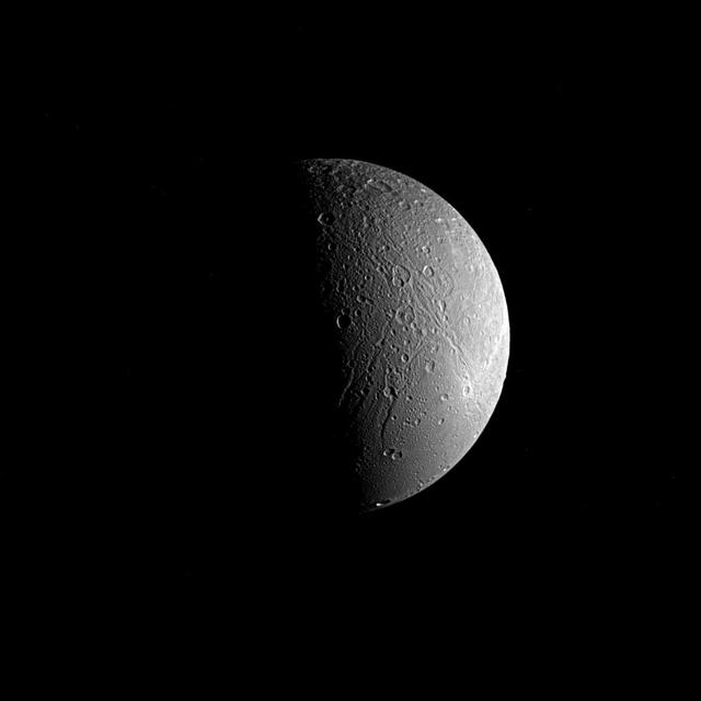
Saturn's moon Dione is captured in this view from NASA's Cassini spacecraft, half in shadow and half in light. Sinuous canyons carve interconnected paths across the moon's icy landscape. Subtle variations in brightness hint at differences in composition, as well as the size and shape of grains in Dione's surface material, or regolith. Cassini spent more than a decade at Saturn studying Dione (698 miles or 1,123 kilometers across) and the planet's many other moons as part of the quest to understand how the moons formed and evolved, and how they are connected. This view looks toward the side of Dione that faces away from Saturn. North is up and rotated 59 degrees to the right. The image was taken in visible light with the Cassini spacecraft narrow-angle camera on June 22, 2017. The view was obtained at a distance of approximately 224,000 miles (360,000 kilometers) from Dione. Image scale is 1.4 mile (2.2 kilometers) per pixel. The Cassini spacecraft ended its mission on Sept. 15, 2017. https://photojournal.jpl.nasa.gov/catalog/PIA21349
The Earth Surface Mineral Dust Source Investigation (EMIT) mission instrument (right) sits in the "trunk" that will travel aboard SpaceX's 25th cargo resupply mission – planned for June 7, 2022 – to the International Space Station. This image was taken May 3, 2022, at SpaceX's Dragonland facility in Florida. Developed at NASA's Jet Propulsion Laboratory in Southern California and launching from Kennedy Space Center in Florida, EMIT will map the world's mineral-dust sources, gathering information about particle color and composition as it orbits over the planet's dry, sparsely vegetated regions. After being mounted on the space station, EMIT will collect measurements of 10 important surface minerals – hematite, goethite, illite, vermiculite, calcite, dolomite, montmorillonite, kaolinite, chlorite, and gypsum – in arid regions between 50-degree south and north latitudes in Africa, Asia, North and South America, and Australia. The data EMIT collects will help scientists better understand the role of airborne dust particles in heating and cooling Earth's atmosphere on global and regional scales. The white covering will prevent the spread of the heat the instrument generates, keeping it from affecting the space station and nearby instruments. EMIT will be one of two pieces of equipment transported to the space station in the external cargo "trunk" on SpaceX's Falcon 9 rocket. The other (left) is a Battery Charge/Discharge Unit. https://photojournal.jpl.nasa.gov/catalog/PIA25148