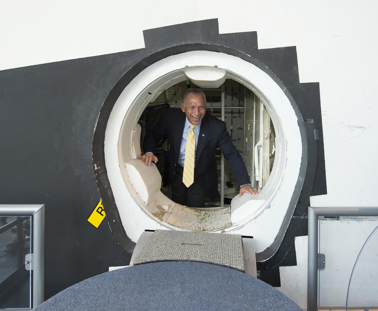
NASA Administrator Charles Bolden is seen as he peers through the hatch opening of the Space Shuttle Trainer Crew Compartment while on a tour of the Museum of Flight, Tuesday, Jan. 15, 2013 in Seattle, Washington. Photo Credit: (NASA/Carla Cioffi)
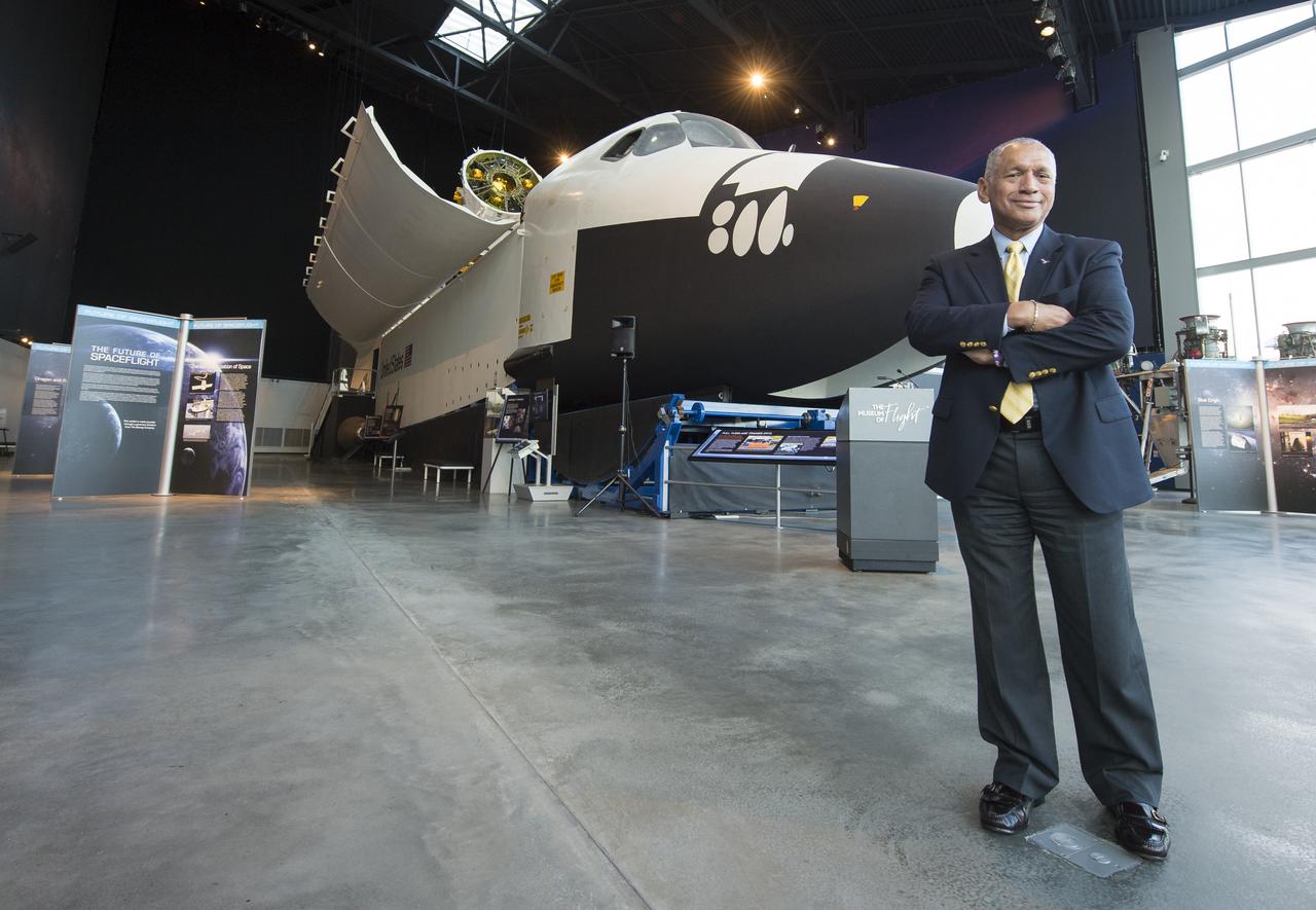
NASA Administrator Charles Bolden poses in front of the Space Shuttle Trainer Crew Compartment in the Charles Simonyi Space Gallery while on a tour at the Museum of Flight on Tuesday, Jan. 15, 2013 in Seattle, Washington. Photo Credit: (NASA/Carla Cioffi)
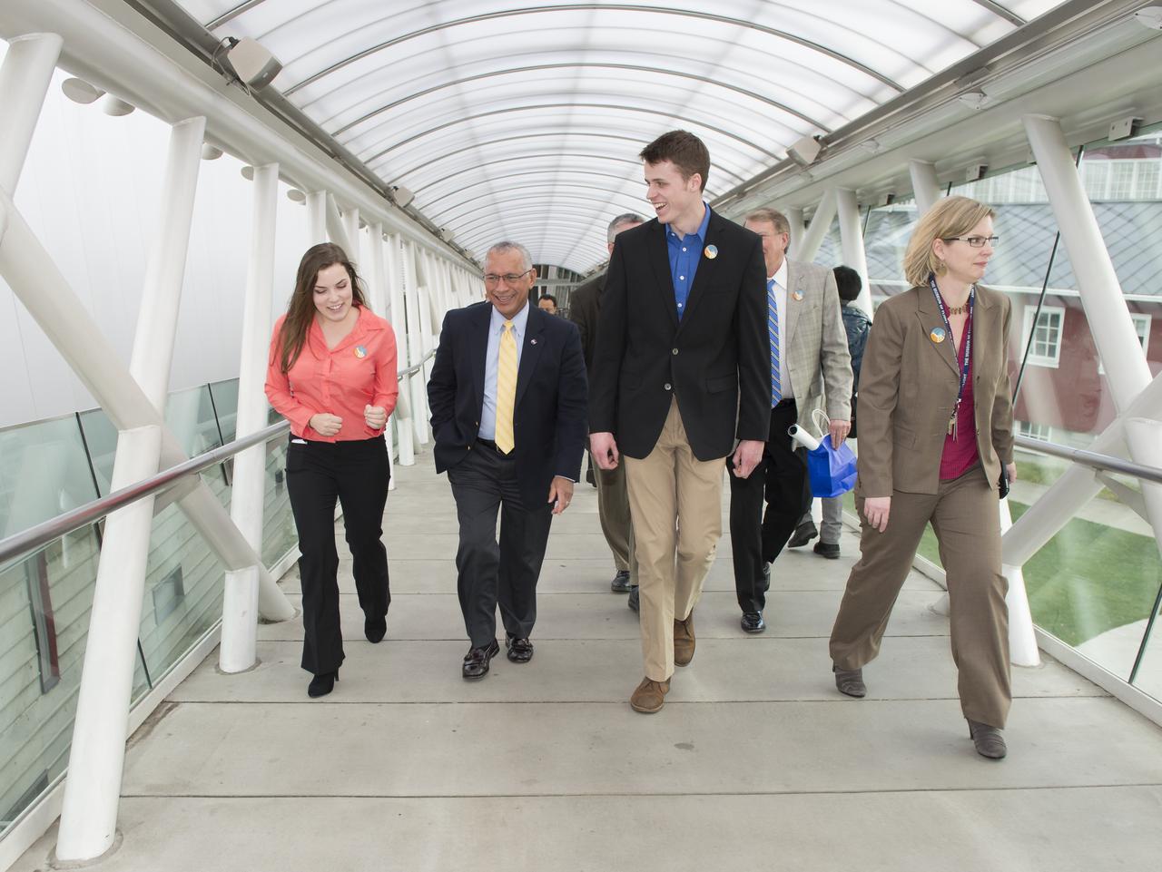
NASA Administrator Charles Bolden, second from left, is seen with Washington Aerospace Scholars Brenna Tuller-Ross, far left, and Alec Lindsey as they escort him on a tour of the Museum of Flight, Tuesday, Jan. 15, 2013 in Seattle, Washington. Photo Credit: (NASA/Carla Cioffi)
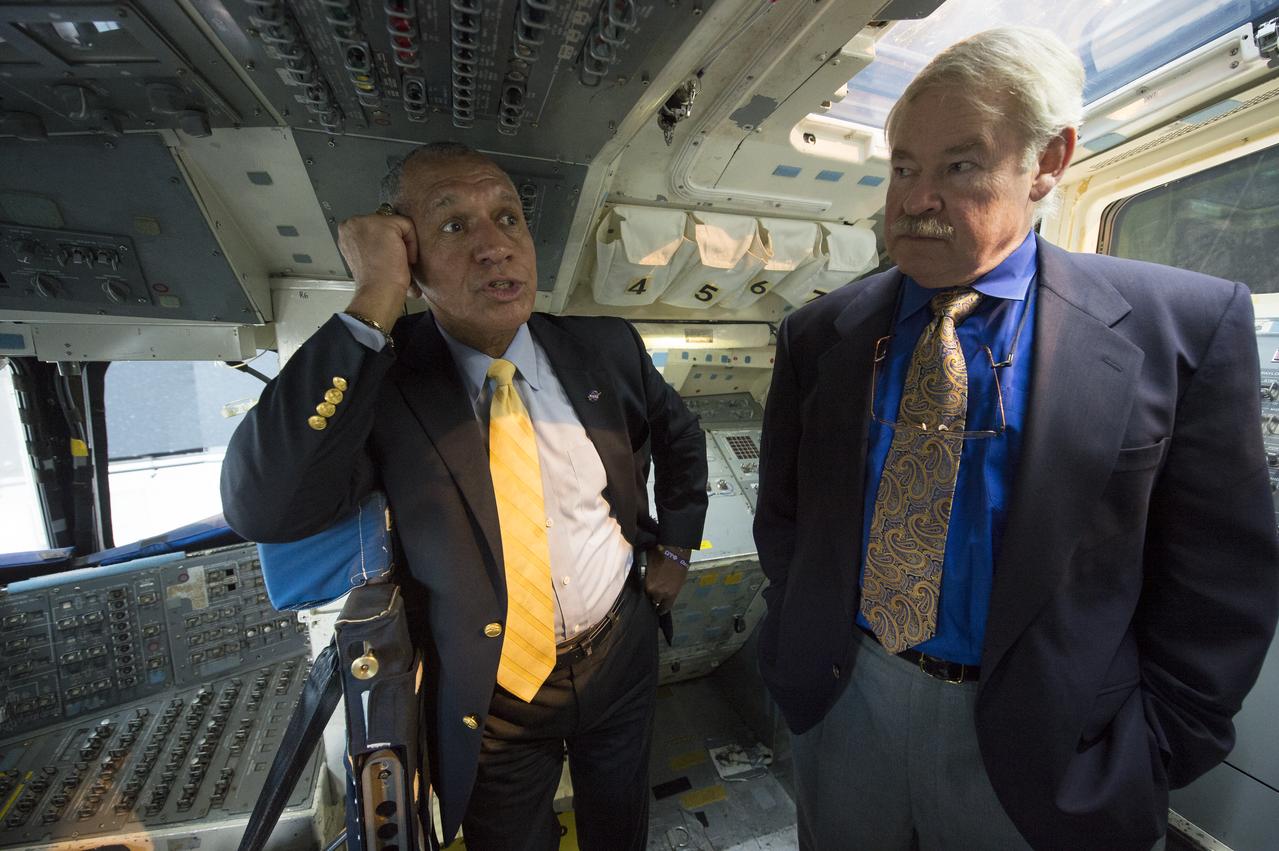
NASA Administrator Charles Bolden, left, is seen with former NASA astronaut John Creighton in the Space Shuttle Trainer Crew Compartment in the Charles Simonyi Space Gallery while on a tour at the Museum of Flight on Tuesday, Jan. 15, 2013 in Seattle, Washington. Photo Credit: (NASA/Carla Cioffi)
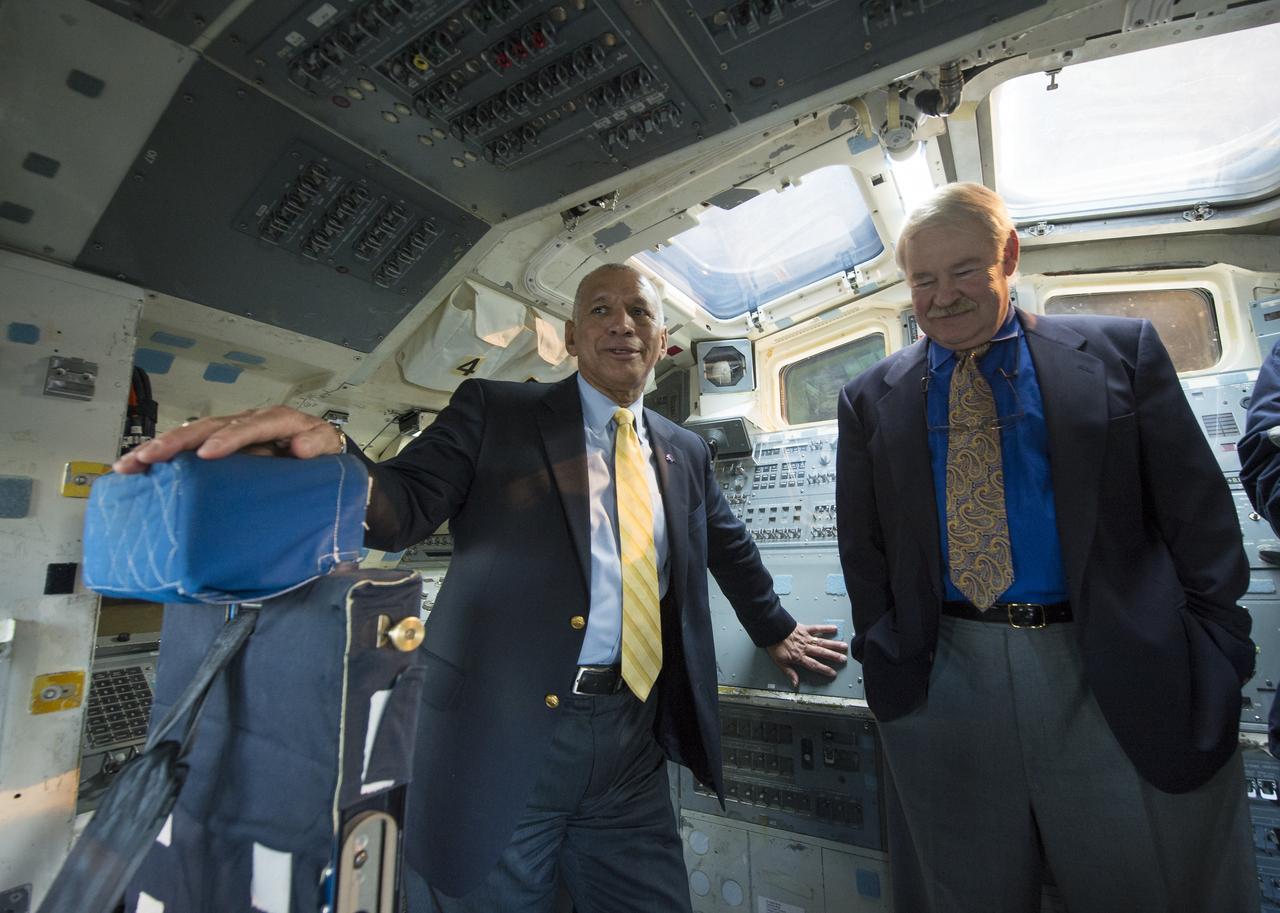
NASA Administrator Charles Bolden, left, is seen with former NASA astronaut John Creighton in the Space Shuttle Trainer Crew Compartment in the Charles Simonyi Space Gallery while on a tour at the Museum of Flight on Tuesday, Jan. 15, 2013 in Seattle, Washington. Photo Credit: (NASA/Carla Cioffi)
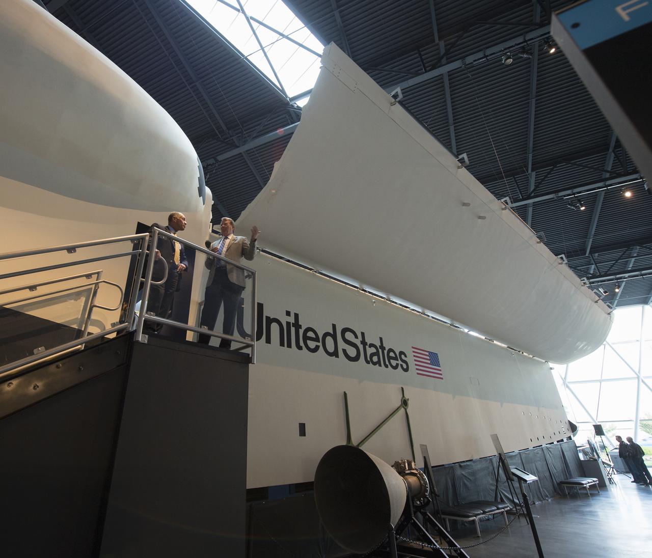
NASA Administrator Charles Bolden, left, is seen with Doug King, president and CEO of the Museum of Flight in Seattle, Washington on Tuesday, Jan. 15, 2013. Bolden toured the Space Shuttle Trainer Crew Compartment in the Charles Simonyi Space Gallery at the museum. Photo Credit: (NASA/Carla Cioffi)
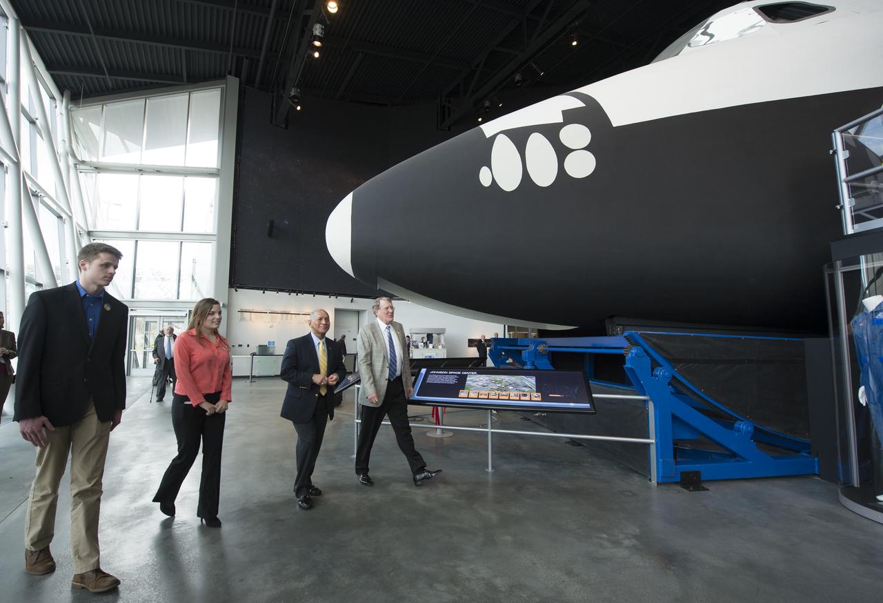
NASA Administrator Charles Bolden, third from left, is seen as he is escorted on a tour of the Space Shuttle Trainer Crew Compartment in the Charles Simonyi Space Gallery at the Museum of Flight, Tuesday, Jan. 15, 2013 in Seattle, Washington. Bolden is joined by Washington Aerospace Scholars Alec Lindsey, far left, Brenna Tuller-Ross and Doug King, far right, president and CEO of the museum. Photo Credit: (NASA/Carla Cioffi)
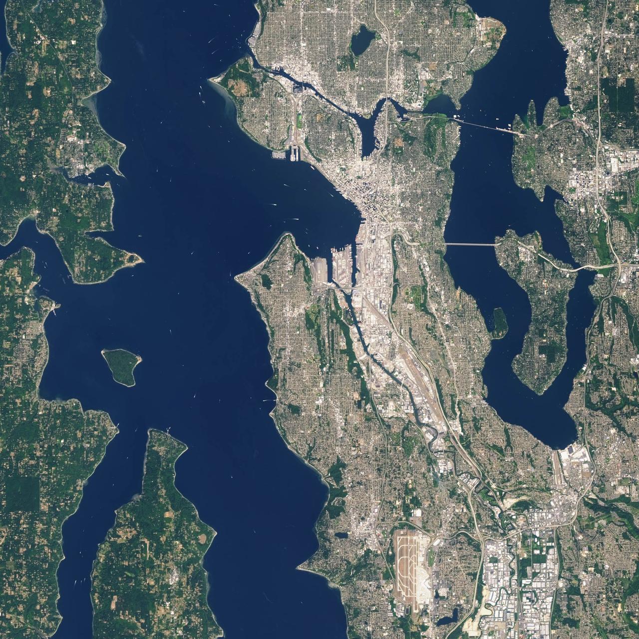
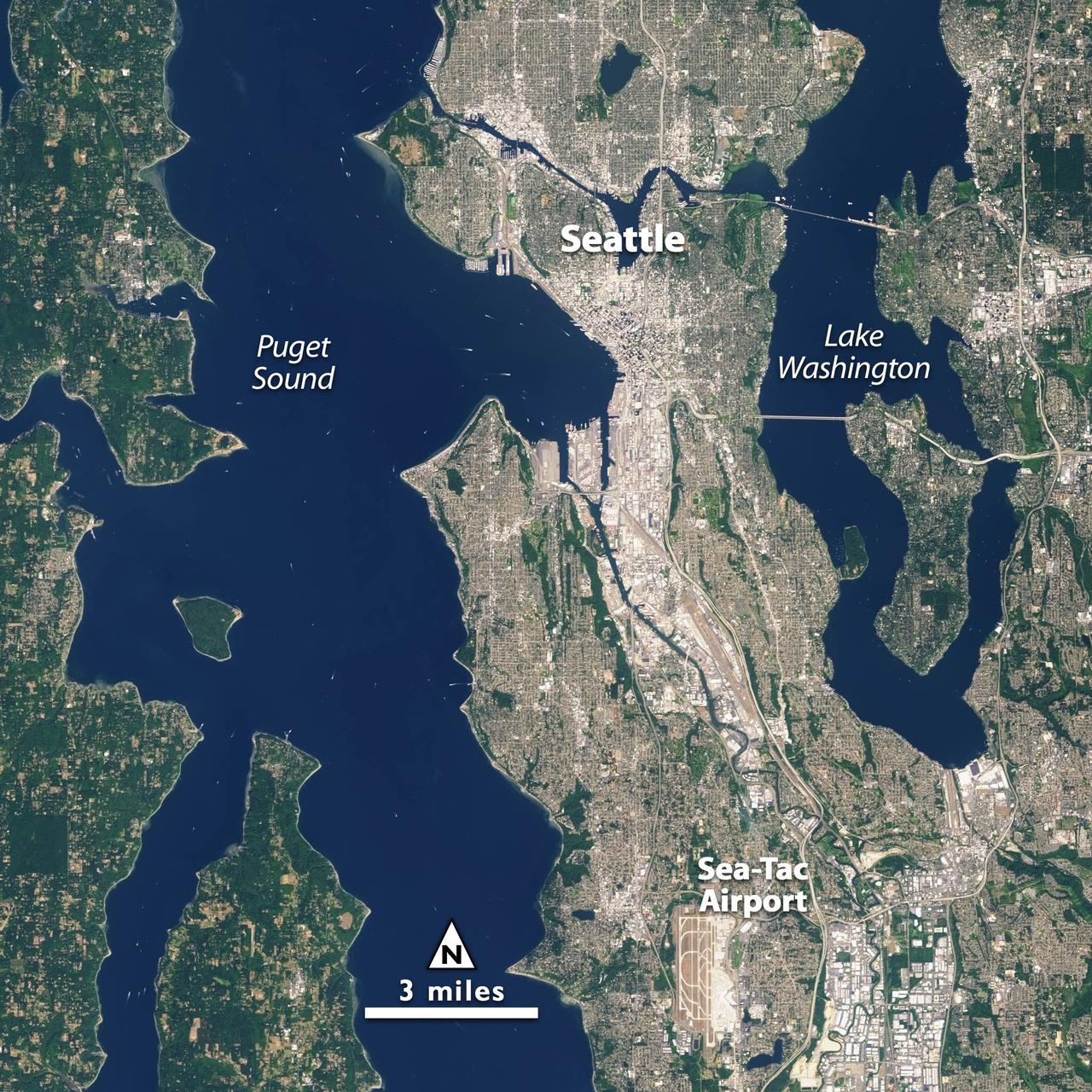
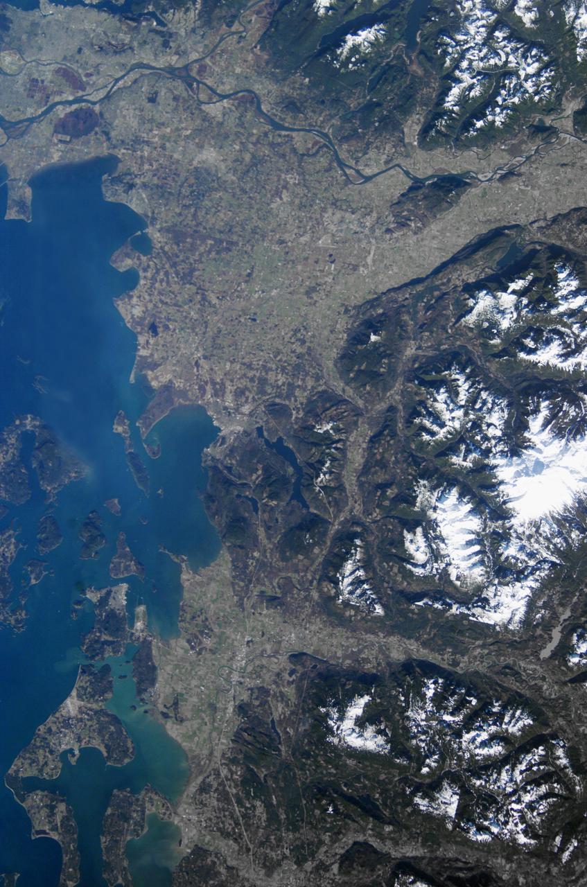
Landsat 7 image of Seattle, Washington acquired August 23, 2014. Landsat 7 is a U.S. satellite used to acquire remotely sensed images of the Earth's land surface and surrounding coastal regions. It is maintained by the Landsat 7 Project Science Office at the NASA Goddard Space Flight Center in Greenbelt, MD. Landsat satellites have been acquiring images of the Earth’s land surface since 1972. Currently there are more than 2 million Landsat images in the National Satellite Land Remote Sensing Data Archive. For more information visit: <a href="http://landsat.usgs.gov/" rel="nofollow">landsat.usgs.gov/</a>..To learn more about the Landsat satellite go to:.<a href="http://landsat.gsfc.nasa.gov/" rel="nofollow">landsat.gsfc.nasa.gov/</a> Credit: NASA/GSFC/Landsat 7 <b><a href="http://www.nasa.gov/audience/formedia/features/MP_Photo_Guidelines.html" rel="nofollow">NASA image use policy.</a></b> <b><a href="http://www.nasa.gov/centers/goddard/home/index.html" rel="nofollow">NASA Goddard Space Flight Center</a></b> enables NASA’s mission through four scientific endeavors: Earth Science, Heliophysics, Solar System Exploration, and Astrophysics. Goddard plays a leading role in NASA’s accomplishments by contributing compelling scientific knowledge to advance the Agency’s mission. <b>Follow us on <a href="http://twitter.com/NASAGoddardPix" rel="nofollow">Twitter</a></b> <b>Like us on <a href="http://www.facebook.com/pages/Greenbelt-MD/NASA-Goddard/395013845897?ref=tsd" rel="nofollow">Facebook</a></b> <b>Find us on <a href="http://instagrid.me/nasagoddard/?vm=grid" rel="nofollow">Instagram</a></b>
Landsat 7 image of Seattle, Washington acquired August 23, 2014. Landsat 7 is a U.S. satellite used to acquire remotely sensed images of the Earth's land surface and surrounding coastal regions. It is maintained by the Landsat 7 Project Science Office at the NASA Goddard Space Flight Center in Greenbelt, MD. Landsat satellites have been acquiring images of the Earth’s land surface since 1972. Currently there are more than 2 million Landsat images in the National Satellite Land Remote Sensing Data Archive. For more information visit: <a href="http://landsat.usgs.gov/" rel="nofollow">landsat.usgs.gov/</a>..To learn more about the Landsat satellite go to:.<a href="http://landsat.gsfc.nasa.gov/" rel="nofollow">landsat.gsfc.nasa.gov/</a> Credit: NASA/GSFC/Landsat 7 <b><a href="http://www.nasa.gov/audience/formedia/features/MP_Photo_Guidelines.html" rel="nofollow">NASA image use policy.</a></b> <b><a href="http://www.nasa.gov/centers/goddard/home/index.html" rel="nofollow">NASA Goddard Space Flight Center</a></b> enables NASA’s mission through four scientific endeavors: Earth Science, Heliophysics, Solar System Exploration, and Astrophysics. Goddard plays a leading role in NASA’s accomplishments by contributing compelling scientific knowledge to advance the Agency’s mission. <b>Follow us on <a href="http://twitter.com/NASAGoddardPix" rel="nofollow">Twitter</a></b> <b>Like us on <a href="http://www.facebook.com/pages/Greenbelt-MD/NASA-Goddard/395013845897?ref=tsd" rel="nofollow">Facebook</a></b> <b>Find us on <a href="http://instagrid.me/nasagoddard/?vm=grid" rel="nofollow">Instagram</a></b>
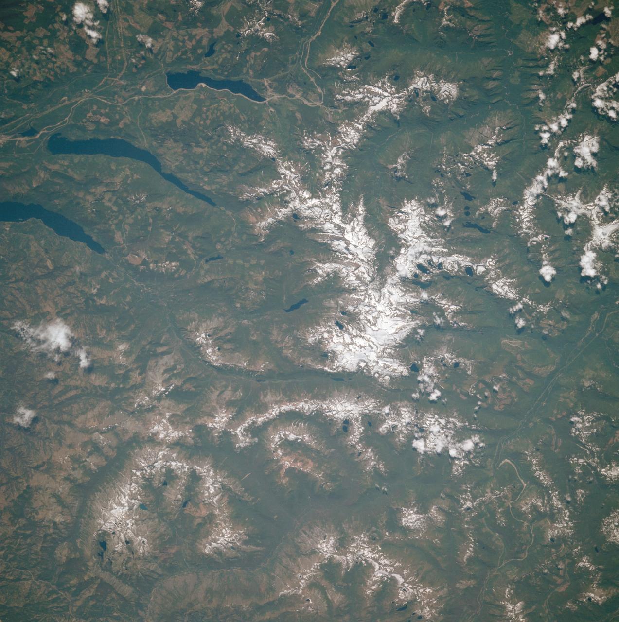
AST-30-2601 (20 July 1975) --- An area of the Cascade Mountains southeast of Seattle in the State of Washington, as photographed from the Apollo spacecraft in Earth orbit during the joint U.S.-USSR Apollo-Soyuz Test Project mission. The view includes Snoqualmie Pass, Cle Elum Lake, Kachess Lake and Keechelus Lake. The picture was taken at an altitude of 228 kilometers (141 statute miles) with a 70mm Hasselblad camera using medium-speed Ektachrome QX-807 type film.
Back by popular demand: THEMIS ART IMAGE #63 Seattle Seahawk fans may recognize their team emblem in the collapse region around this crater
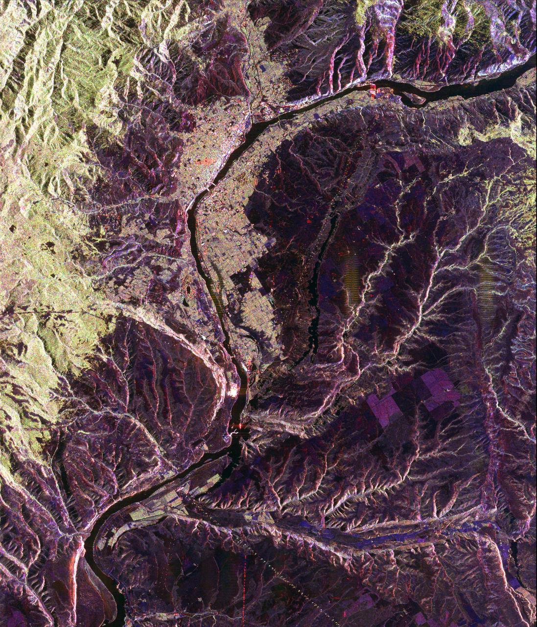
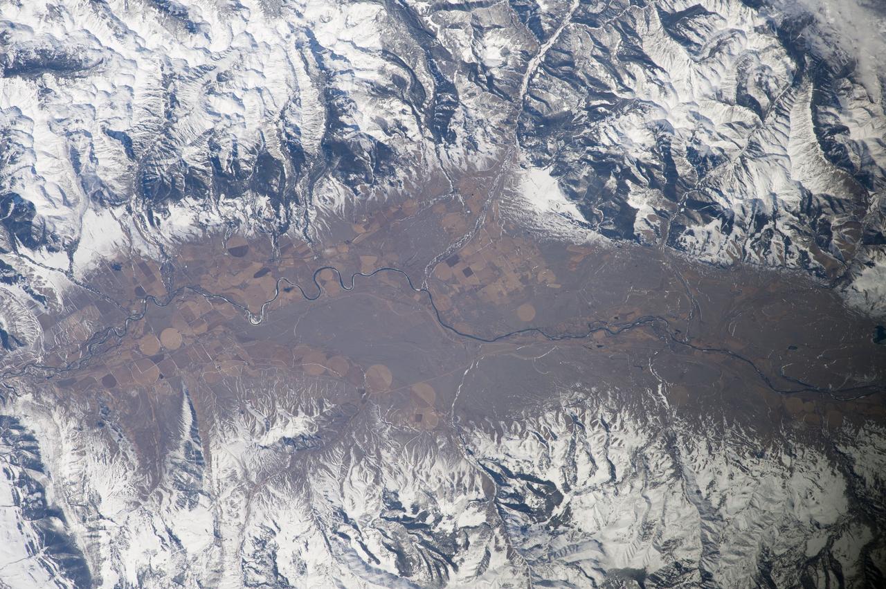
This spaceborne radar image shows a segment of the Columbia River as it passes through the area of Wenatchee, Washington, about 220 kilometers 136 miles east of Seattle.
STS047-151-488 (12 - 20 Sept 1992) --- In this large format camera image, the forested Cascade Range appears along the left side; the Pacific Ocean, on the right. The frame was photographed as the Space Shuttle Endeavour flew north to south over Vancouver and Seattle. Many peaks in the Cascades reach altitudes greater than 9,000 feet and remain snowcapped even in mid-summer. The Strait of Juan de Fuca separates the Olympic Peninsula (top right) from Vancouver Island (bottom right). Snowcapped Mt. Olympus (7,965 feet) is one of the wettest places in the continental United States, with rainfall in excess of 120 inches per year. The port cities of Seattle and Tacoma occupy the heavily indented coastline of Puget Sound (top center). They appear as light-colored areas on the left side of the Sound. The angular street pattern of Tacoma is visible at the top of the picture. The international boundary between Canada and the United States of America runs across the middle of the view. The city of Victoria (center) is the light patch on the tip of Vancouver Island. Canada's Fraser River Delta provides flat topography on which the cities of Vancouver, Burnaby, and New Westminster were built. These cities appear as the light-colored area just left of center. The Fraser River can be seen snaking its way out of the mountains at the apex of the delta. Numerous ski resorts dot the slopes of the mountains (bottom left) that rise immediately to the north of Vancouver. In the same area the blue water of Harrison and other, smaller lakes fills some of the valleys that were excavated by glaciers in the "recent" geological past, according to NASA scientists studying the photography. A Linhof camera was used to expose the frame.

iss065e376897 (Sept. 13, 2021) --- The International Space Station orbits 266 miles above the north Pacific Ocean off the coast of British Columbia, Canada, looking across the city lights of northwest America into a sunrise highlighted by an aurora.
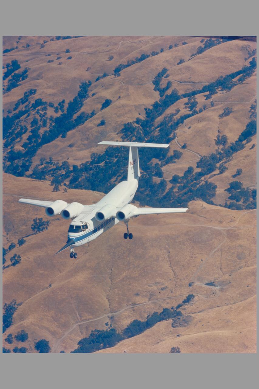
Air to air of the QSRA (NASA 715). on maiden flight to Ames from Seattle, Washington after coversion
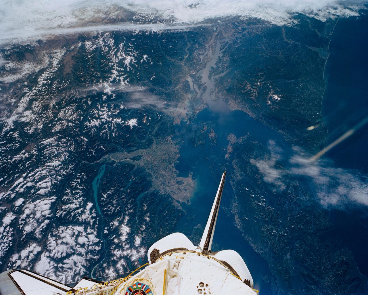
Earth observation taken by the Expedition 39 crew aboard the ISS. Image downlinked in folder: Seattle to Florida. and released by astronaut on Twitter.
Earth observation taken by the Expedition 39 crew aboard the ISS. Image downlinked in folder: Seattle to Florida, and released by astronaut on Twitter.
Earth observation taken by the Expedition 39 crew aboard the ISS. Image downlinked in folder: Seattle to Florida, and released by astronaut on Twitter.
Earth observation taken by the Expedition 39 crew aboard the ISS. Image downlinked in folder: Seattle, Galveston, etc., and released by astronaut on Twitter.
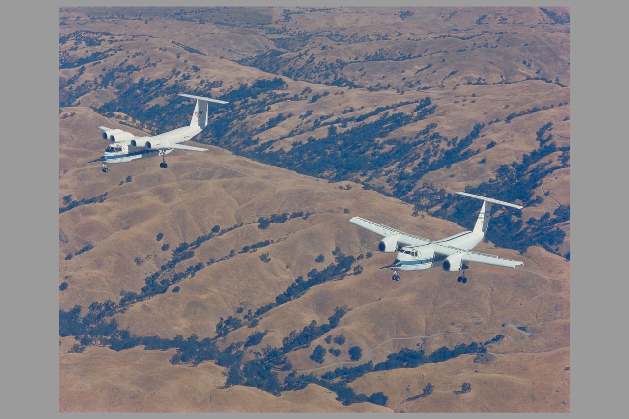
Air to air of the QSRA (NASA 715) and C-8A (NASA 716) on maiden flight to Ames from Seattle, Washington after coversion
Earth Observation taken during a day pass by the Expedition 40 crew aboard the International Space Station (ISS). Folder lists this only as: Seattle area.
ISS008-E-15493 (12 February 2004) --- A regional picture of Mount Baker, Washington, showing its proximity to Seattle and Vancouver, is featured in this image photographed by an Expedition 8 crewmember on the International Space Station (ISS). The Cascade Range is an arc of volcanoes that extends from southwestern British Columbia to northern California. One of the six major composite volcanoes is Mount Baker in northern Washington close to the Canadian border, about 85 miles north-northeast of Seattle and 65 miles southeast of Vancouver, British Columbia.
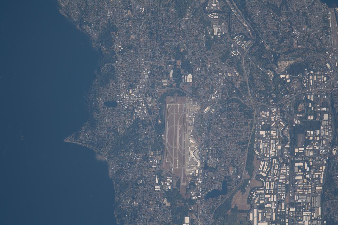
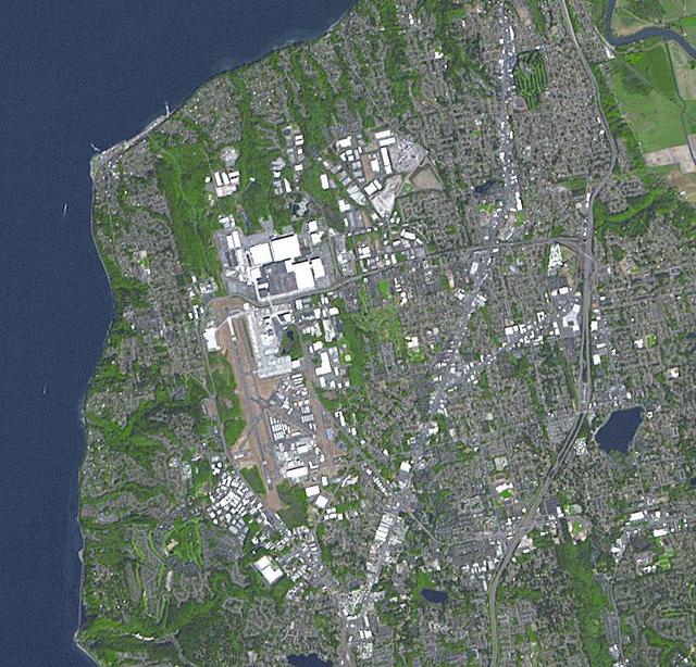
iss069e061160 (Aug. 16, 2023) --- Seattle-Tacoma International Airport near the Puget Sound in northwest Washington is pictured from the International Space Station as it orbited 264 miles above the Evergreen State.

iss068e011266 (Oct. 1, 2022) --- Vancouver in British Columbia, Canada (at top), and Seattle, Washington (lower right) are pictured from the International Space Station as it orbited 262 miles above North America. Credit: NASA/Bob Hines
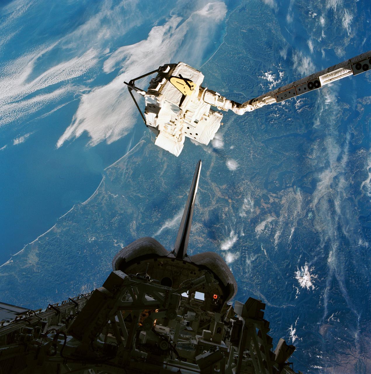
STS085-722-087 (7 - 19 August 1997) --- The Cryogenic Infrared Spectrometers and Telescopes for the Atmosphere-Shuttle Pallet Satellite-2 (CRISTA-SPAS-2) having just been grappled by the Space Shuttle Discovery's Remote Manipulator System (RMS), is backdropped against Puget Sound and the Seattle, Washington area. A short while later, the satellite was re-berthed in the cargo bay, silhouetted in this 70mm frame. This image was exposed through the aft flight deck windows of Discovery.
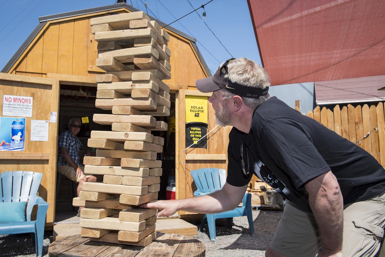
Eirik Olsen, of Seattle, Washington, plays giant Jenga while waiting to watch the total solar eclipse in Madras, Oregon on Saturday, August 19, 2017. The eclipse will be sweeping across a narrow portion of the contiguous United States from Lincoln Beach, Oregon to Charleston, South Carolina on August 21. A partial solar eclipse will be visible across the entire North American continent along with parts of South America, Africa, and Europe. Photo Credit: (NASA/Aubrey Gemignani)
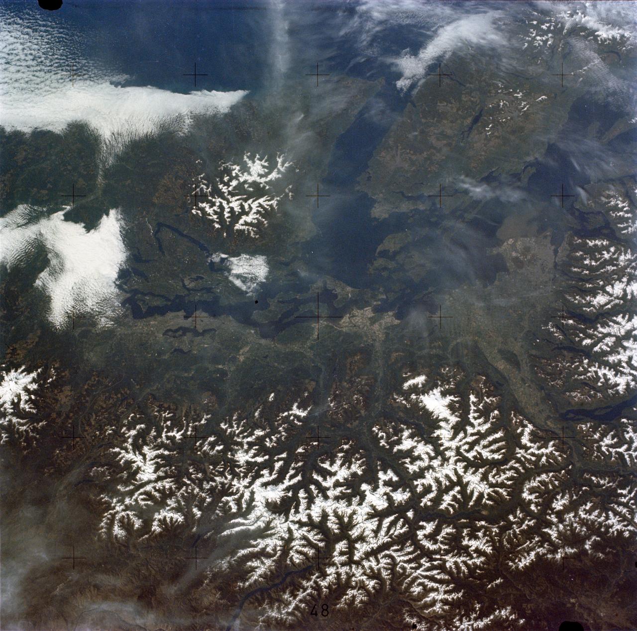
SL2-05-458 (22 June 1973) --- Portions of northwest Washington State (48.0N, 122.5) can be seen in this view as well as portions of British Columbia, Canada. The snow covered Cascade Mountains are on the eastern side of the scene. Vancouver Island is visible in the northeast corner of the photo. The strait of Juan de Fuca separates Vancouver Island from the northwest corner of Washington. Seattle is near the center and the snow covered Olympic Mountains are to the east. Photo credit: NASA
When Boeing decided to build the 747, they had to build a factory large enough to construct several at the same time. They started building the factory in 1967, in Everett, Washington, 35 km north of Seattle. The main building covers 39 hectares (98 acres), and encloses 13.3 million cubic meters (472 million cubic feet). This is the largest building in the world. The image was acquired September 15, 2017, covers an area of 10.8 by 11.3 kilometers, and is located at 47.9 degrees north, 122.3 degrees west. https://photojournal.jpl.nasa.gov/catalog/PIA23000
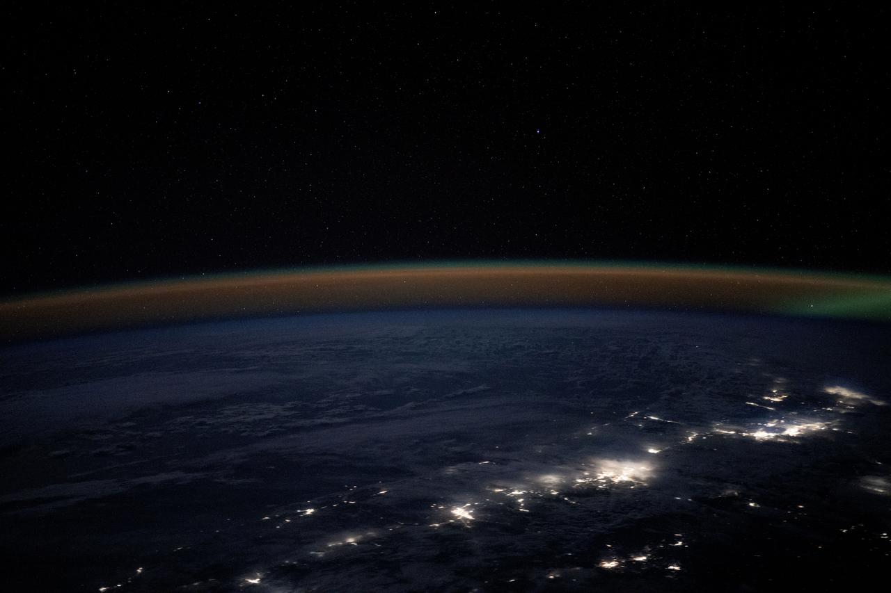
iss072e725029 (March 5, 2025) --- An atmospheric glow blankets Earth's horizon as city lights outline the northwestern coast of the United States and Canada highlighting major urban areas including Portland, Oregon; Seattle, Washington; and Vancouver, BC, Canada. The International Space Station was orbiting 261 miles above North America at approximately 10:12 p.m. local time.
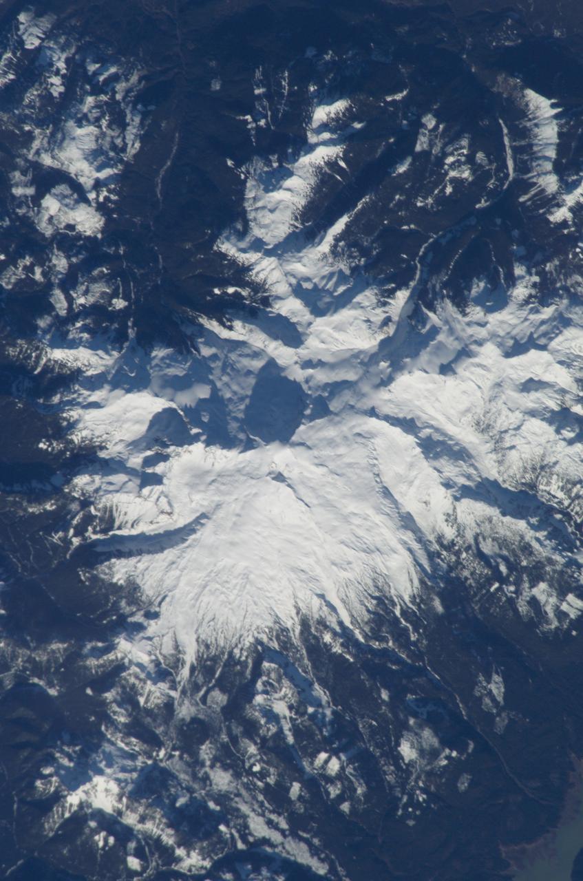
ISS008-E-15491 (12 February 2004) --- This scene featuring Mount Baker, Washington, was photographed by an Expedition 8 crewmember on the International Space Station (ISS). The high-resolution image provides details of the rough terrain near the summit and on the upper flanks. The Cascade Range is an arc of volcanoes that extends from southwestern British Columbia to northern California. One of the six major composite volcanoes is Mount Baker in northern Washington close to the Canadian border, about 85 miles north-northeast of Seattle and 65 miles southeast of Vancouver, British Columbia.

Gary Lagerloef, left, Aquarius Principal Investigator, Earth & Space Research, Seattle, speaks at a press conference on NASA's Aquarius/SAC-D mission to study the salinity of Earth's oceans from space on Tuesday, May 17, 2011 at NASA Headquarters in Washington. The mission is a collaboration between NASA and Argentina's space agency Comision Nacional de Actividades Especiales (CONAE), with participation from Brazil, Canada, France and Italy. The Aquarius/SAC-D observatory will launch June 9, 2011 from Vandenberg Air Force Base in California. Photo Credit: (NASA/Carla Cioffi)

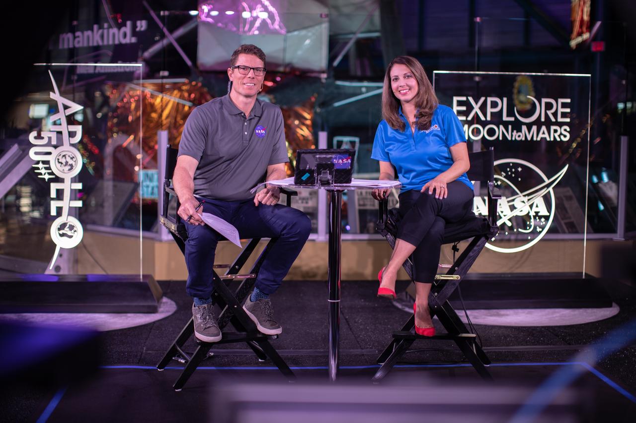
Derrol Nail, left, and Marie Lewis, NASA Office of Communications, host a special Apollo 11 show titled “NASA’s Giant Leaps: Past and Future” on July 19, 2019. The show, which honored the heroes of Apollo and examined NASA’s future plans, was broadcast live from Kennedy Space Center’s Apollo/Saturn V Center in Florida. It featured segments from across the nation, including The National Mall in Washington, NASA’s Johnson Space Center in Houston, Neil Armstrong’s hometown of Wapakoneta, Ohio, and the Apollo 11 command module on display at the Museum of Flight in Seattle.
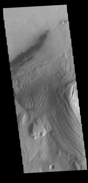
Today's VIS image is located in Gale Crater. Home to the Curiosity Rover since August of 2012, Gale crater is 154km in diameter (96 miles). Multiple features within the crater are visible in this image, including dunes, wind and water etched rock, layered central mound (Aeolis Mons — common name Mount Sharp), and small channels. Aeolis Mons rises 18,000 ft (5,500 m) from the crater floor, higher than Mount Rainier rises above Seattle. Orbit Number: 81879 Latitude: -4.7719 Longitude: 137.564 Instrument: VIS Captured: 2020-05-30 05:35 https://photojournal.jpl.nasa.gov/catalog/PIA24085
Gary Lagerloef, right, Aquarius Principal Investigator, Earth & Space Research, Seattle, speaks at a press conference on NASA's Aquarius/SAC-D mission to study the salinity of Earth's oceans from space on Tuesday, May 17, 2011 at NASA Headquarters in Washington. The mission is a collaboration between NASA and Argentina's space agency Comision Nacional de Actividades Especiales (CONAE), with participation from Brazil, Canada, France and Italy. The Aquarius/SAC-D observatory will launch June 9, 2011 from Vandenberg Air Force Base in California. Photo Credit: (NASA/Carla Cioffi)
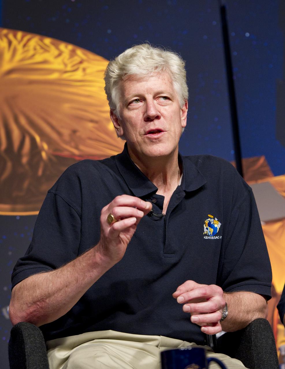
Gary Lagerloef, Aquarius Principal Investigator, Earth & Space Research, Seattle, speaks at a press conference on NASA's Aquarius/SAC-D mission to study the salinity of Earth's oceans from space on Tuesday, May 17, 2011 at NASA Headquarters in Washington. The mission is a collaboration between NASA and Argentina's space agency Comision Nacional de Actividades Especiales (CONAE), with participation from Brazil, Canada, France and Italy. The Aquarius/SAC-D observatory will launch June 9, 2011 from Vandenberg Air Force Base in California. Photo Credit: (NASA/Carla Cioffi)
Derrol Nail, left, and Marie Lewis, NASA Office of Communications, host a special Apollo 11 show titled “NASA’s Giant Leaps: Past and Future” on July 19, 2019. The show, which honored the heroes of Apollo and examined NASA’s future plans, was broadcast live from Kennedy Space Center’s Apollo/Saturn V Center in Florida. It featured segments from across the nation, including The National Mall in Washington, NASA’s Johnson Space Center in Houston, Neil Armstrong’s hometown of Wapakoneta, Ohio, and the Apollo 11 command module on display at the Museum of Flight in Seattle.
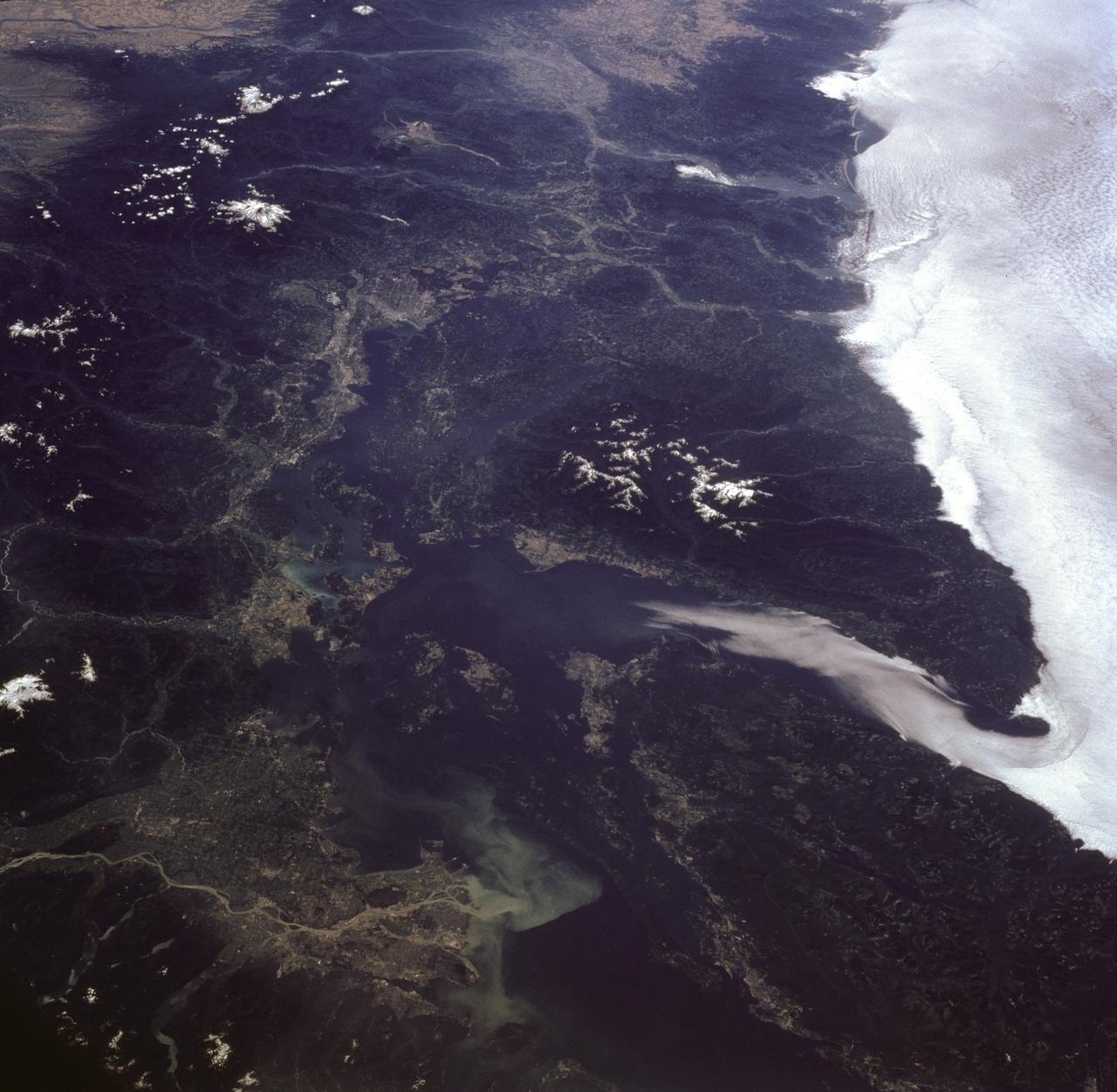
STS085-716-081 (7-19 August 1997) --- This photograph provides a southerly view from Vancouver, B. C. in the foreground, to Portland, Oregon near the top. Coastal stratus, a common occurrence, hugs the Pacific coastline and laps into Puget sound. The silty Fraser River cuts through Vancouver and empties into Puget Sound with a large, milky plume of sediment (bottom). Near the top of the image, the Columbia River runs across the Cascades (between Mt. Adams and Mt. Hood) and the Coast Ranges to the Pacific Ocean. Snow caps the highest peaks of the Olympic Mountains (near center), and the Cascade volcanoes of Rainier (closest to Seattle), Adams and Hood (top). The smaller, gray mountain just south (above and right) of Rainier is Mt. St. Helens.
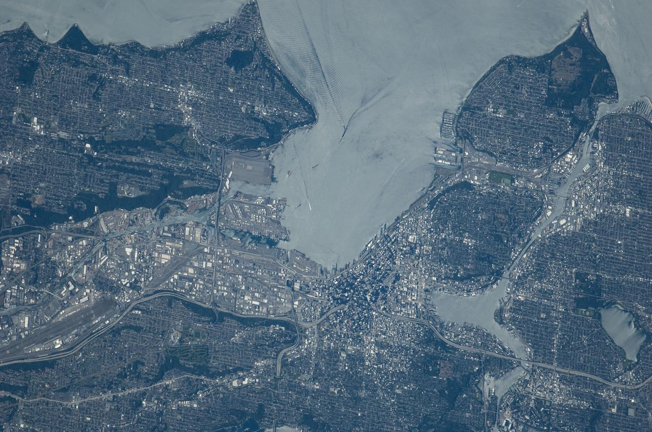
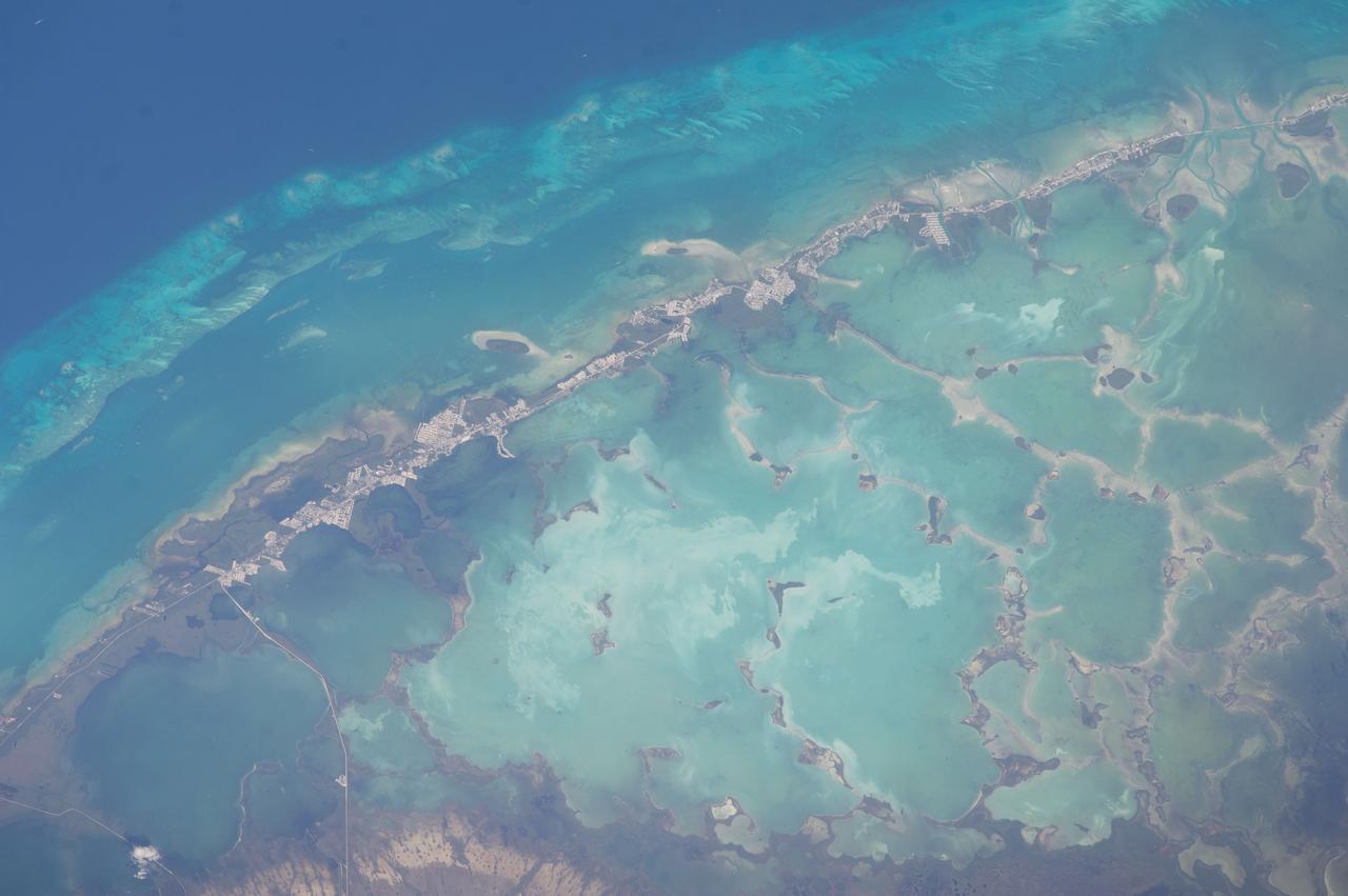
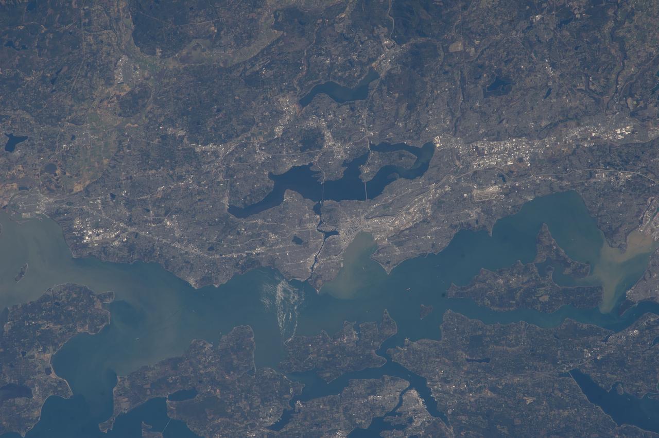
ISS040-E-124198 (6 Sept. 2014) --- Puget Sound is partly reflecting the sun in this detailed image taken by an Expedition 40 crew member on the International Space Station. Patterns of boat wakes are prominent in the sun’s partial reflection zone. The difference between the boat wakes in this view relates to the speed of the boat and the particular patterns (of several) that happen to be captured in the specific light reflection angles at the time the image was taken. The land areas show parts of Seattle. The darkest areas with rectangular grids are suburbs richly covered with trees. The broadly gray zones of the central city (bottom center) are brighter where structures are lower, as in the harbor zone (Harbor Island), and darker where the shadows of high-rise buildings downtown cast black shadows. Interstate Highway 5 bisects downtown.
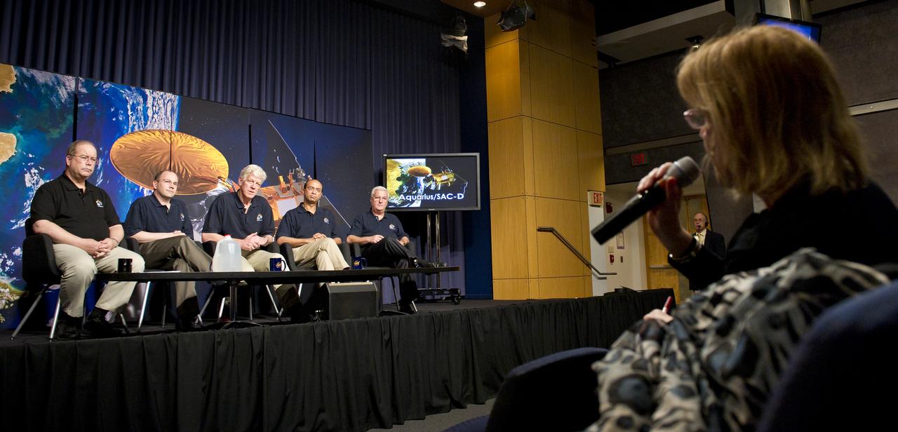
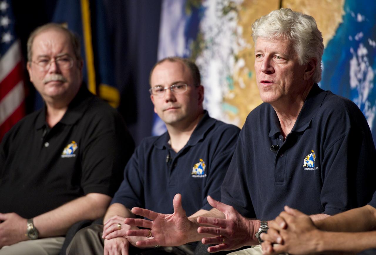
A reporter asks a question to the panel of scientists assembled at the Aquarius/SAC-D press conference on Tuesday, May 17, 2011 at NASA Headquarters in Washington. Seated from left are Eric Lindstrom, Aquarius Program Scientist, NASA Headquarters; Eric Ianson, Aquarius Program Executive, NASA Headquarters; Gary Lagerloef, Aquarius Principal Investigator, Earth & Space Research, Seattle; Amit Sen, Aquarius Project Manager, NASA Jet Propulsion Laboratory and Daniel Caruso, SAC-D Project Manager, CONAE, Argentina. The mission will study the salinity of the Earth's oceans from space. Aquarius/SAC-D is a collaboration between NASA and Argentina's space agency Comision Nacional de Actividades Especiales (CONAE), with participation from Brazil, Canada, France and Italy. The Aquarius/SAC-D observatory will launch June 9, 2011 from Vandenberg Air Force Base in California. Photo Credit: (NASA/Carla Cioffi)
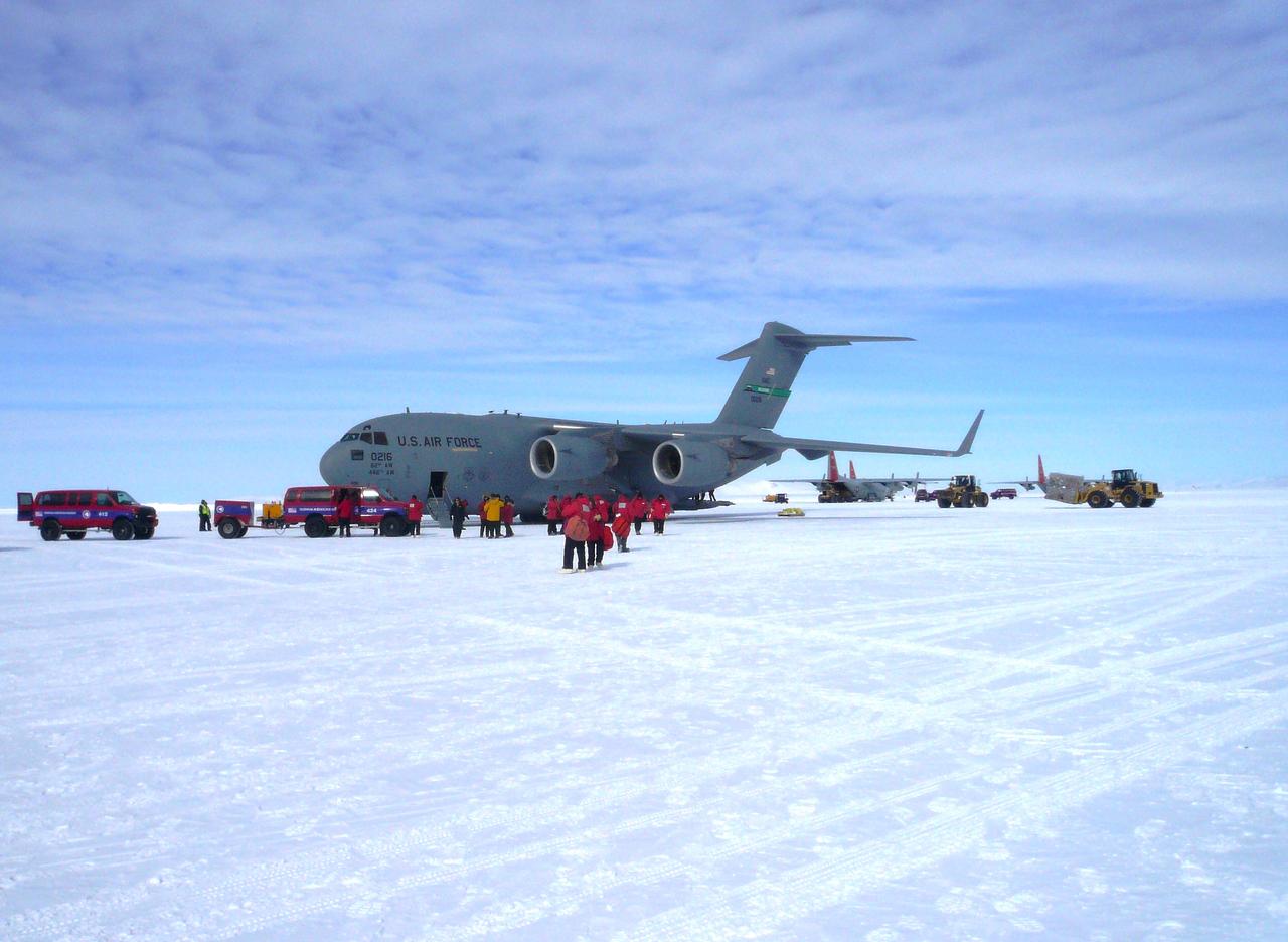
A U.S. Air Force C-17 transport aircraft sits on the sea ice runway at the National Science Foundation's McMurdo Station in Antarctica following a transit flight from Christchurch, New Zealand that transported IceBridge personnel and gear on Nov. 12, 2013. The C-17 aircraft that fly to Antarctica are operated by the U.S. Air Force's 62nd and 446th Airlift Wings based at Joint Base Lewis-McChord near Seattle, Wash. Credit: NASA/Goddard/George Hale NASA's Operation IceBridge is an airborne science mission to study Earth's polar ice. For more information about IceBridge, visit: <a href="http://www.nasa.gov/icebridge" rel="nofollow">www.nasa.gov/icebridge</a> <b><a href="http://www.nasa.gov/audience/formedia/features/MP_Photo_Guidelines.html" rel="nofollow">NASA image use policy.</a></b> <b><a href="http://www.nasa.gov/centers/goddard/home/index.html" rel="nofollow">NASA Goddard Space Flight Center</a></b> enables NASA’s mission through four scientific endeavors: Earth Science, Heliophysics, Solar System Exploration, and Astrophysics. Goddard plays a leading role in NASA’s accomplishments by contributing compelling scientific knowledge to advance the Agency’s mission. <b>Follow us on <a href="http://twitter.com/NASA_GoddardPix" rel="nofollow">Twitter</a></b> <b>Like us on <a href="http://www.facebook.com/pages/Greenbelt-MD/NASA-Goddard/395013845897?ref=tsd" rel="nofollow">Facebook</a></b> <b>Find us on <a href="http://instagram.com/nasagoddard?vm=grid" rel="nofollow">Instagram</a></b>

NASA Operation IceBridge pilot Michael Anderson chats with Lt. Colonel Brent Keenan aboard a U.S. Air Force C-17 transport aircraft during a flight from Christchurch, New Zealand, to the U.S. Antarctic Program's McMurdo Station in Antarctica on Nov. 12, 2013. The C-17s that ferry people, equipment and supplies to Antarctica are operated by the U.S. Air Force's 62nd and 446th Airlift Wings based at Joint Base Lewis-McChord near Seattle, Wash. NASA's Operation IceBridge is an airborne science mission to study Earth's polar ice. In 2013, IceBridge is conducting its first field campaign directly from Antarctica. For more information about IceBridge, visit: <a href="http://www.nasa.gov/icebridge" rel="nofollow">www.nasa.gov/icebridge</a> Credit: NASA/Goddard/Jefferson Beck <b><a href="http://www.nasa.gov/audience/formedia/features/MP_Photo_Guidelines.html" rel="nofollow">NASA image use policy.</a></b> <b><a href="http://www.nasa.gov/centers/goddard/home/index.html" rel="nofollow">NASA Goddard Space Flight Center</a></b> enables NASA’s mission through four scientific endeavors: Earth Science, Heliophysics, Solar System Exploration, and Astrophysics. Goddard plays a leading role in NASA’s accomplishments by contributing compelling scientific knowledge to advance the Agency’s mission. <b>Follow us on <a href="http://twitter.com/NASA_GoddardPix" rel="nofollow">Twitter</a></b> <b>Like us on <a href="http://www.facebook.com/pages/Greenbelt-MD/NASA-Goddard/395013845897?ref=tsd" rel="nofollow">Facebook</a></b> <b>Find us on <a href="http://instagram.com/nasagoddard?vm=grid" rel="nofollow">Instagram</a></b>
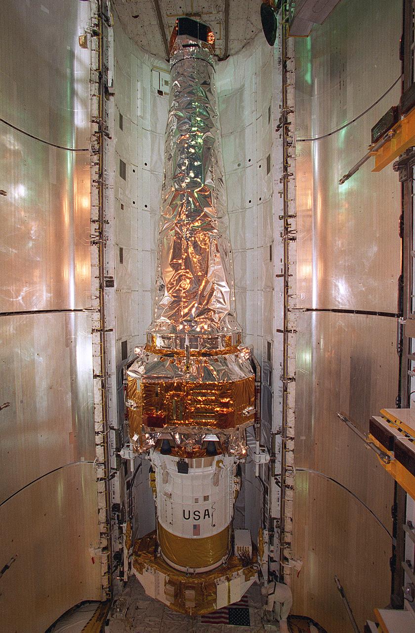
In this photograph, the Chandra X-Ray Observatory (CXO) was installed and mated to the Inertial Upper Stage (IUS) inside the Shuttle Columbia's cargo bay at the Kennedy Space Center. The CXO will help astronomers world-wide better understand the structure and evolution of the universe by studying powerful sources of x-rays such as exploding stars, matter falling into black holes, and other exotic celestial objects. X-ray astronomy can only be done from space because Earth's atmosphere blocks x-rays from reaching the surface. The Observatory provides images that are 50 times more detailed than previous x-ray missions. At more than 45 feet in length and weighing more than 5 tons, the CXO was carried into low-Earth orbit by the Space Shuttle Columbia (STS-93 mission) on July 22, 1999. The Observatory was deployed from the Shuttle's cargo bay at 155 miles above the Earth. Two firings of an attached IUS rocket, and several firings of its own onboard rocket motors, after separating from the IUS, placed the Observatory into its working orbit. The IUS is a solid rocket used to place spacecraft into orbit or boost them away from the Earth on interplanetary missions. Since its first use by NASA in 1983, the IUS has supported a variety of important missions, such as the Tracking and Data Relay Satellite, Galileo spacecraft, Magellan spacecraft, and Ulysses spacecraft. The IUS was built by the Boeing Aerospace Co., at Seattle, Washington and managed by the Marshall Space Flight Center.
These IceBridge team members aboard a huge U.S. Air Force C-17 transport aircraft are ready to step out into the cold Antarctic air. The C-17 aircraft that fly to Antarctica are operated by the U.S. Air Force's 62nd and 446th Airlift Wings based at Joint Base Lewis-McChord near Seattle, Wash. Credit: NASA/Goddard/Michael Studinger NASA's Operation IceBridge is an airborne science mission to study Earth's polar ice. For more information about IceBridge, visit: <a href="http://www.nasa.gov/icebridge" rel="nofollow">www.nasa.gov/icebridge</a> <b><a href="http://www.nasa.gov/audience/formedia/features/MP_Photo_Guidelines.html" rel="nofollow">NASA image use policy.</a></b> <b><a href="http://www.nasa.gov/centers/goddard/home/index.html" rel="nofollow">NASA Goddard Space Flight Center</a></b> enables NASA’s mission through four scientific endeavors: Earth Science, Heliophysics, Solar System Exploration, and Astrophysics. Goddard plays a leading role in NASA’s accomplishments by contributing compelling scientific knowledge to advance the Agency’s mission. <b>Follow us on <a href="http://twitter.com/NASA_GoddardPix" rel="nofollow">Twitter</a></b> <b>Like us on <a href="http://www.facebook.com/pages/Greenbelt-MD/NASA-Goddard/395013845897?ref=tsd" rel="nofollow">Facebook</a></b> <b>Find us on <a href="http://instagram.com/nasagoddard?vm=grid" rel="nofollow">Instagram</a></b>
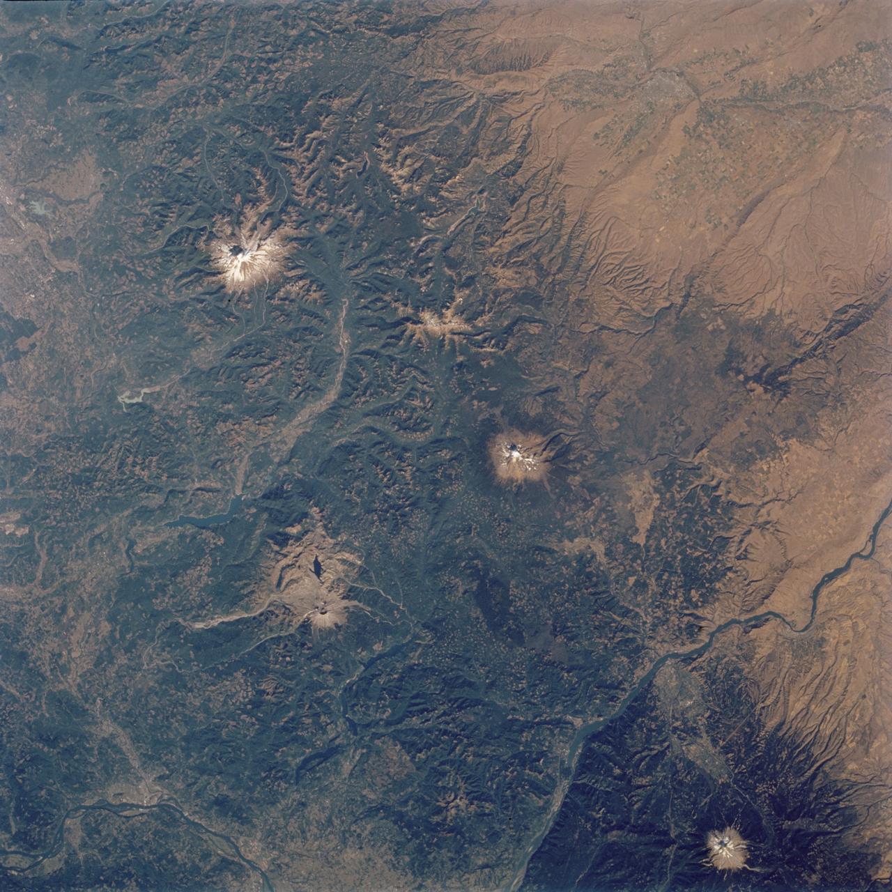
STS112-704-142 (7-18 October 2002) --- (For orientation purposes, north is toward the top left corner). Green colors of the forests of the Cascade Mountains dominate this view, photographed from the Earth-orbiting Space Shuttle Atlantis. Browner colors (top right) are the semiarid plains of the Columbia Basin, in the rain shadow of the Cascades. The highest peaks in this part of the Cascades are four volcanoes. The amount of snow is a good indication of their altitude. The highest is Mt. Rainier (14,410 feet) with the greatest amount of white snow (top left). Seattle lies immediately downslope (top left margin). Mt. Adams (12,276) lies due south in the middle of the view. Mt. Hood (11,235 feet) in the lower right corner, lies south of the great gorge of the Columbia River (which crosses the lower right and then the lower left corners of the view). The river flows broadly west (left) to the Pacific Ocean (out of the picture left). Mt. St Helens (8,364 feet), the snow-free brown patch lower left, was too low to retain snow after the recent fall. According to geologists studying the STS-112 photography, even from the altitude of the Space Shuttle, the intact south half of the cone can be discerned. The geologists point out that the famous blast of 1980 not only destroyed the north side of the cone but blew down the green forest for many square miles on the north side (brown signature).

Photo taken aboard a U.S. Air Force C-17 transport aircraft during a flight from Christchurch, New Zealand, to the U.S. Antarctic Program's McMurdo Station in Antarctica on Nov. 12, 2013. The C-17s that ferry people, equipment and supplies to Antarctica are operated by the U.S. Air Force's 62nd and 446th Airlift Wings based at Joint Base Lewis-McChord near Seattle, Wash. NASA's Operation IceBridge is an airborne science mission to study Earth's polar ice. In 2013, IceBridge is conducting its first field campaign directly from Antarctica. For more information about IceBridge, visit: <a href="http://www.nasa.gov/icebridge" rel="nofollow">www.nasa.gov/icebridge</a> Credit: NASA/Goddard/Jefferson Beck <b><a href="http://www.nasa.gov/audience/formedia/features/MP_Photo_Guidelines.html" rel="nofollow">NASA image use policy.</a></b> <b><a href="http://www.nasa.gov/centers/goddard/home/index.html" rel="nofollow">NASA Goddard Space Flight Center</a></b> enables NASA’s mission through four scientific endeavors: Earth Science, Heliophysics, Solar System Exploration, and Astrophysics. Goddard plays a leading role in NASA’s accomplishments by contributing compelling scientific knowledge to advance the Agency’s mission. <b>Follow us on <a href="http://twitter.com/NASA_GoddardPix" rel="nofollow">Twitter</a></b> <b>Like us on <a href="http://www.facebook.com/pages/Greenbelt-MD/NASA-Goddard/395013845897?ref=tsd" rel="nofollow">Facebook</a></b> <b>Find us on <a href="http://instagram.com/nasagoddard?vm=grid" rel="nofollow">Instagram</a></b>

Operation IceBridge team members board a U.S. Air Force C-17 transport aircraft for a flight from Christchurch, New Zealand, to the U.S. Antarctic Program's McMurdo Station in Antarctica on Nov. 12, 2013. The C-17s that ferry people, equipment and supplies to Antarctica are operated by the U.S. Air Force's 62nd and 446th Airlift Wings based at Joint Base Lewis-McChord near Seattle, Wash. NASA's Operation IceBridge is an airborne science mission to study Earth's polar ice. In 2013, IceBridge is conducting its first field campaign directly from Antarctica. For more information about IceBridge, visit: <a href="http://www.nasa.gov/icebridge" rel="nofollow">www.nasa.gov/icebridge</a> Credit: NASA/Goddard/Jefferson Beck <b><a href="http://www.nasa.gov/audience/formedia/features/MP_Photo_Guidelines.html" rel="nofollow">NASA image use policy.</a></b> <b><a href="http://www.nasa.gov/centers/goddard/home/index.html" rel="nofollow">NASA Goddard Space Flight Center</a></b> enables NASA’s mission through four scientific endeavors: Earth Science, Heliophysics, Solar System Exploration, and Astrophysics. Goddard plays a leading role in NASA’s accomplishments by contributing compelling scientific knowledge to advance the Agency’s mission. <b>Follow us on <a href="http://twitter.com/NASA_GoddardPix" rel="nofollow">Twitter</a></b> <b>Like us on <a href="http://www.facebook.com/pages/Greenbelt-MD/NASA-Goddard/395013845897?ref=tsd" rel="nofollow">Facebook</a></b> <b>Find us on <a href="http://instagram.com/nasagoddard?vm=grid" rel="nofollow">Instagram</a></b>
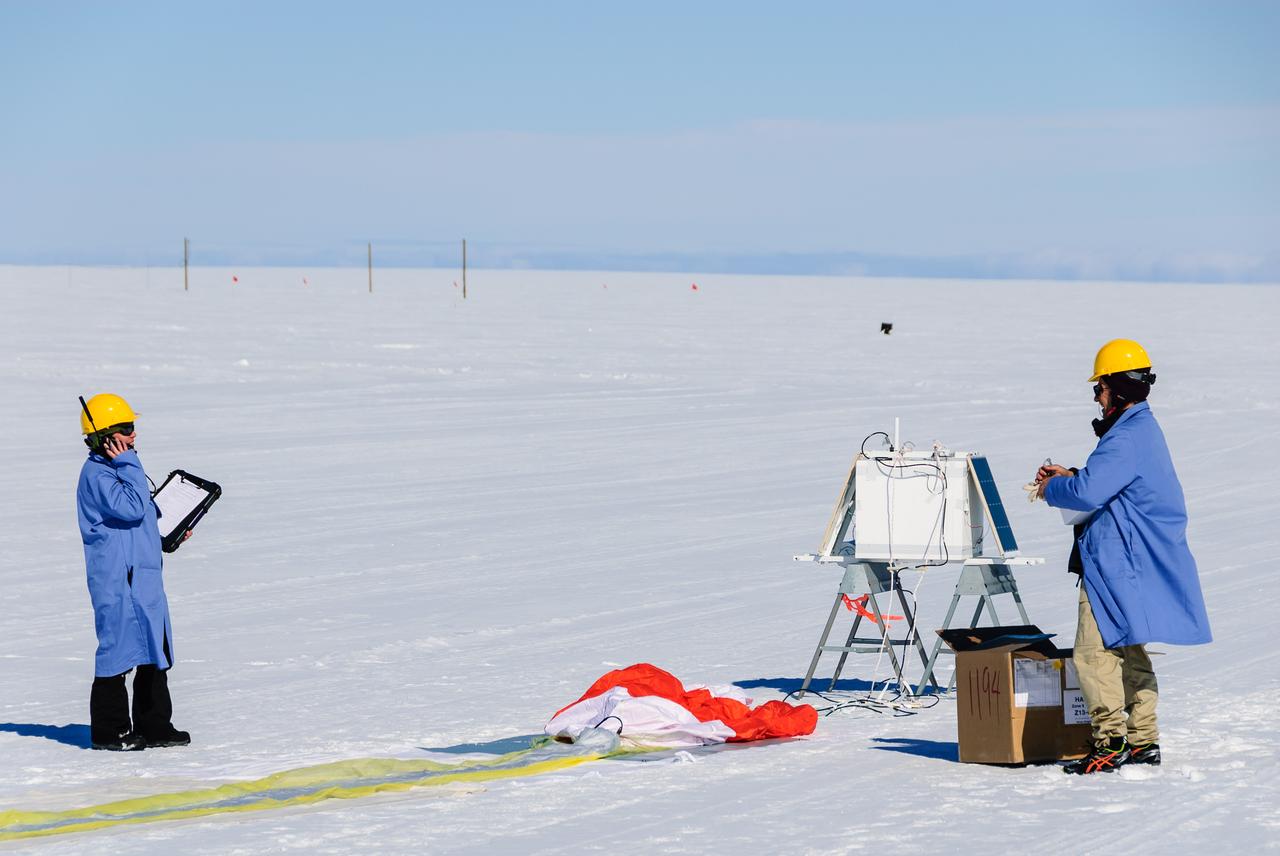
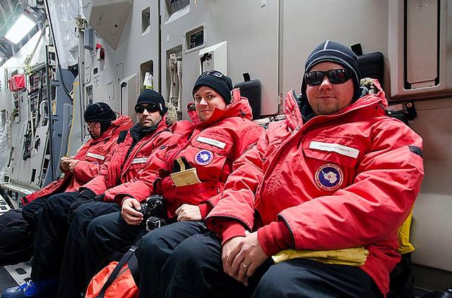
Researchers communicate with the BARREL ground station during preparations for launch. The white box in the background is the science payload and the orange and white parachute can be seen on the ground in front of it. On the left is BARREL Principal Investigator Robyn Millan of Dartmouth College in Hanover, N.H.; on the right is BARREL Co-Investigator Michael McCarthy of the University of Washington in Seattle. Credit: NASA/Goddard/BARREL/M. Krzysztofowicz Read more: <a href="http://www.nasa.gov/content/goddard/nasas-barrel-returns-successful-from-antarctica" rel="nofollow">www.nasa.gov/content/goddard/nasas-barrel-returns-success...</a> -- Three months, 20 balloons, and one very successful campaign. The team for NASA's BARREL – short for Balloon Array for Radiation belt Relativistic Electron Losses -- mission returned from Antarctica in March 2014. BARREL's job is to help unravel the mysterious Van Allen belts, two gigantic donuts of radiation that surround Earth, which can shrink and swell in response to incoming energy and particles from the sun and sometimes expose satellites to harsh radiation. While in Antarctica, the team launched 20 balloons carrying instruments that sense charged particles that are scattered into the atmosphere from the belts, spiraling down the magnetic fields near the South Pole. Each balloon traveled around the pole for up to three weeks. The team will coordinate the BARREL data with observations from NASA's two Van Allen Probes to better understand how occurrences in the belts relate to bursts of particles funneling down toward Earth. BARREL team members will be on hand at the USA Science and Engineering Festival in DC on April 26 and 27, 2014 for the exhibit Space Balloons: Exploring the Extremes of Space Weather. <b><a href="http://www.nasa.gov/audience/formedia/features/MP_Photo_Guidelines.html" rel="nofollow">NASA image use policy.</a></b> <b><a href="http://www.nasa.gov/centers/goddard/home/index.html" rel="nofollow">NASA Goddard Space Flight Center</a></b> enables NASA’s mission through four scientific endeavors: Earth Science, Heliophysics, Solar System Exploration, and Astrophysics. Goddard plays a leading role in NASA’s accomplishments by contributing compelling scientific knowledge to advance the Agency’s mission. <b>Follow us on <a href="http://twitter.com/NASAGoddardPix" rel="nofollow">Twitter</a></b> <b>Like us on <a href="http://www.facebook.com/pages/Greenbelt-MD/NASA-Goddard/395013845897?ref=tsd" rel="nofollow">Facebook</a></b> <b>Find us on <a href="http://instagram.com/nasagoddard?vm=grid" rel="nofollow">Instagram</a></b>