
Ship tracks above the northern Pacific Ocean. NASA image captured July 3, 2010. Satellite: Aqua NASA/GSFC/Jeff Schmaltz/MODIS Land Rapid Response Team To learn more about MODIS go to: <a href="http://rapidfire.sci.gsfc.nasa.gov/gallery/?latest" rel="nofollow">rapidfire.sci.gsfc.nasa.gov/gallery/?latest</a> To learn more about ship tracks go to: <a href="http://visibleearth.nasa.gov/view_rec.php?id=2370" rel="nofollow">visibleearth.nasa.gov/view_rec.php?id=2370</a> To watch a video on ship tracks go to: <a href="http://www.youtube.com/watch?v=Vsri2sOAjWo&feature=player_embedded#" rel="nofollow">www.youtube.com/watch?v=Vsri2sOAjWo&feature=player_em...</a>! <b><a href="http://www.nasa.gov/centers/goddard/home/index.html" rel="nofollow">NASA Goddard Space Flight Center</a></b> is home to the nation's largest organization of combined scientists, engineers and technologists that build spacecraft, instruments and new technology to study the Earth, the sun, our solar system, and the universe.
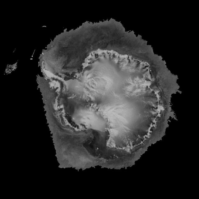
NASA QuikScat satellite instrument kept an eye on an iceberg the size of Rhode Island, the first time this space technology had been used to track a potential threat to international shipping.

STS071-745-006 (27 June-7 July 1995) --- This view shows a ship track, probably in the northern Pacific Ocean, where a ship has caused clouds to form more thickly directly above the path of this ship. This track is therefore visible even though the ship itself is not. Ship tracks are thought to be caused by particles thrown up into the air by the ship, from smokestack emissions and from water particles generated by the ship moving through the sea. Under favorable weather conditions, water condenses around these particles to form clouds, in this case thicker "popcorn" clouds than already exists in the area. Ongoing studies are attempting to understand this phenomenon better.

These images, taken by the MISR instrument aboard NASA Terra spacecraft , are centered over the Pacific Ocean, about 1600 kilometers west of San Francisco. 3D glasses are necessary to view this image.
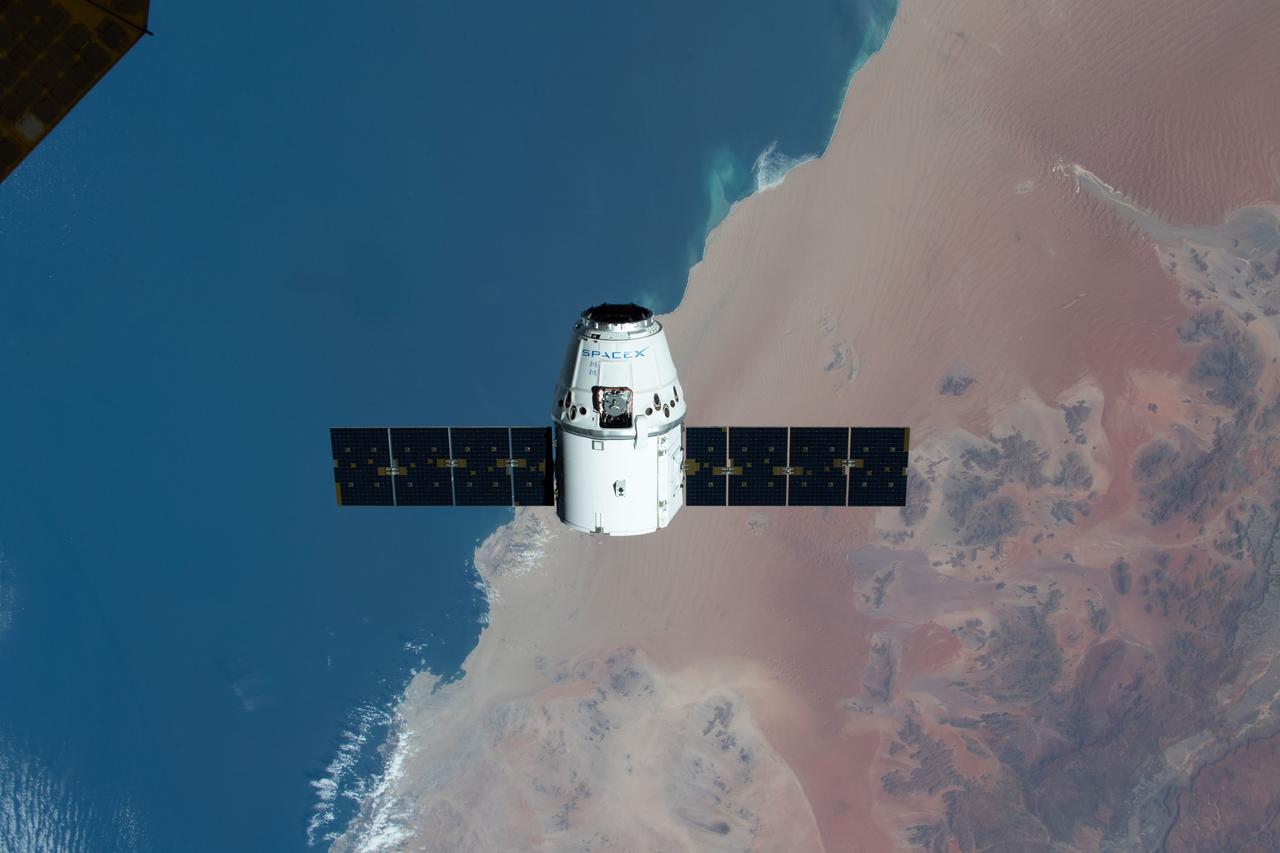
iss062e085660 (March 9, 2020) --- The SpaceX Dragon resupply ship is pictured approaching the International Space Station as both spacecraft were soaring on a southeastern orbital track 267 miles above the Atlantic coast of Namibia .
![CAPE CANAVERAL, Fla. – The shipping crate is being removed from the STSS Demonstrator SV-1 spacecraft in the Astrotech payload processing facility in Titusville, Fla. The spacecraft is a midcourse tracking technology demonstrator, part of an evolving ballistic missile defense system. STSS is capable of tracking objects after boost phase and provides trajectory information to other sensors. It will be launched by NASA for the Missile Defense Agency in late summer. Photo credit: NASA/Tim Jacobs (Approved for Public Release 09-MDA-4800 [30 July 09] )](https://images-assets.nasa.gov/image/KSC-2009-4619/KSC-2009-4619~medium.jpg)
CAPE CANAVERAL, Fla. – The shipping crate is being removed from the STSS Demonstrator SV-1 spacecraft in the Astrotech payload processing facility in Titusville, Fla. The spacecraft is a midcourse tracking technology demonstrator, part of an evolving ballistic missile defense system. STSS is capable of tracking objects after boost phase and provides trajectory information to other sensors. It will be launched by NASA for the Missile Defense Agency in late summer. Photo credit: NASA/Tim Jacobs (Approved for Public Release 09-MDA-4800 [30 July 09] )
![CAPE CANAVERAL, Fla. – In the Astrotech payload processing facility in Titusville, Fla. , the STSS Demonstrator SV-1 spacecraft is lifted from its shipping crate. The spacecraft is a midcourse tracking technology demonstrator, part of an evolving ballistic missile defense system. STSS is capable of tracking objects after boost phase and provides trajectory information to other sensors. It will be launched by NASA for the Missile Defense Agency in late summer. Photo credit: NASA/Tim Jacobs (Approved for Public Release 09-MDA-4800 [30 July 09] )](https://images-assets.nasa.gov/image/KSC-2009-4620/KSC-2009-4620~medium.jpg)
CAPE CANAVERAL, Fla. – In the Astrotech payload processing facility in Titusville, Fla. , the STSS Demonstrator SV-1 spacecraft is lifted from its shipping crate. The spacecraft is a midcourse tracking technology demonstrator, part of an evolving ballistic missile defense system. STSS is capable of tracking objects after boost phase and provides trajectory information to other sensors. It will be launched by NASA for the Missile Defense Agency in late summer. Photo credit: NASA/Tim Jacobs (Approved for Public Release 09-MDA-4800 [30 July 09] )
![CAPE CANAVERAL, Fla. – In the Astrotech payload processing facility in Titusville, Fla. , the STSS Demonstrator SV-1 spacecraft is lifted clear from its shipping crate. The spacecraft is a midcourse tracking technology demonstrator, part of an evolving ballistic missile defense system. STSS is capable of tracking objects after boost phase and provides trajectory information to other sensors. It will be launched by NASA for the Missile Defense Agency in late summer. Photo credit: NASA/Tim Jacobs (Approved for Public Release 09-MDA-4800 [30 July 09] )](https://images-assets.nasa.gov/image/KSC-2009-4621/KSC-2009-4621~medium.jpg)
CAPE CANAVERAL, Fla. – In the Astrotech payload processing facility in Titusville, Fla. , the STSS Demonstrator SV-1 spacecraft is lifted clear from its shipping crate. The spacecraft is a midcourse tracking technology demonstrator, part of an evolving ballistic missile defense system. STSS is capable of tracking objects after boost phase and provides trajectory information to other sensors. It will be launched by NASA for the Missile Defense Agency in late summer. Photo credit: NASA/Tim Jacobs (Approved for Public Release 09-MDA-4800 [30 July 09] )
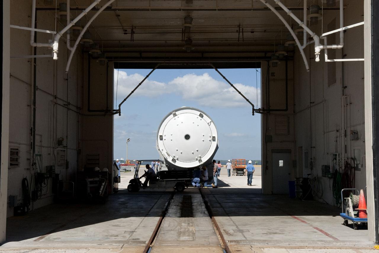
TITUSVILLE, Fla. - Technicians begin the process of removing the Tracking and Data Relay Satellite, TDRS-K, from the shipping container after arrival at the Astrotech payload processing facility in Titusville, Fla. near NASA’s Kennedy Space Center. Launch of the TDRS-K on the Atlas V rocket is planned for January 29, 2013. The TDRS-K spacecraft is part of the next-generation series in the Tracking and Data Relay Satellite System, a constellation of space-based communication satellites providing tracking, telemetry, command and high-bandwidth data return services. For more information, visit http://www.nasa.gov/mission_pages/tdrs/index.html Photo credit: NASA/Kim Shiflett
TITUSVILLE, Fla. - Technicians begin the process of removing the Tracking and Data Relay Satellite, TDRS-K, from the shipping container after arrival at the Astrotech payload processing facility in Titusville, Fla. near NASA’s Kennedy Space Center. Launch of the TDRS-K on the Atlas V rocket is planned for January 29, 2013. The TDRS-K spacecraft is part of the next-generation series in the Tracking and Data Relay Satellite System, a constellation of space-based communication satellites providing tracking, telemetry, command and high-bandwidth data return services. For more information, visit http://www.nasa.gov/mission_pages/tdrs/index.html Photo credit: NASA/Kim Shiflett
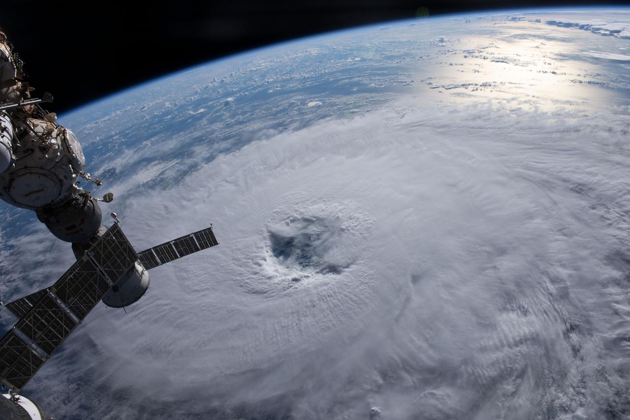
iss069e090103 (Sept. 19, 2023) --- Category 1 Hurricane Nigel is pictured on a northeasterly track in the Atlantic Ocean as the International Space Station orbited 259 miles above. At left, is the Soyuz MS-23 crew ship docked to the Prichal docking module.
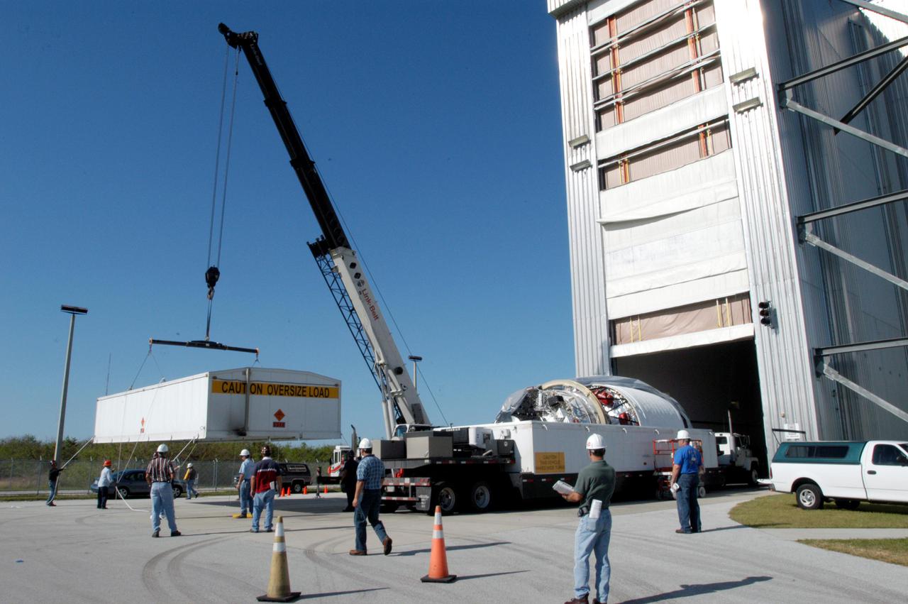
![CAPE CANAVERAL, Fla. – At NASA Kennedy Space Center's Shuttle Landing Facility, the shipping container with the STSS Demonstrator SV-2spacecraft waits to be offloaded from the U.S. Air Force C-17 aircraft. The spacecraft will be transferred to the Astrotech payload processing facility in Titusville, Fla. The spacecraft is a midcourse tracking technology demonstrator, part of an evolving ballistic missile defense system. STSS is capable of tracking objects after boost phase and provides trajectory information to other sensors. It will be launched by NASA for the Missile Defense Agency in late summer. Photo credit: NASA/Jack Pfaller (Approved for Public Release 09-MDA-4616 [27 May 09])](https://images-assets.nasa.gov/image/KSC-2009-3661/KSC-2009-3661~medium.jpg)
CAPE CANAVERAL, Fla. – At NASA Kennedy Space Center's Shuttle Landing Facility, the shipping container with the STSS Demonstrator SV-2spacecraft waits to be offloaded from the U.S. Air Force C-17 aircraft. The spacecraft will be transferred to the Astrotech payload processing facility in Titusville, Fla. The spacecraft is a midcourse tracking technology demonstrator, part of an evolving ballistic missile defense system. STSS is capable of tracking objects after boost phase and provides trajectory information to other sensors. It will be launched by NASA for the Missile Defense Agency in late summer. Photo credit: NASA/Jack Pfaller (Approved for Public Release 09-MDA-4616 [27 May 09])
![CAPE CANAVERAL, Fla. – At NASA Kennedy Space Center's Shuttle Landing Facility, the shipping container with the STSS Demonstrator SV-2spacecraft has been moved out of the U.S. Air Force C-17 aircraft. The spacecraft will be transferred to the Astrotech payload processing facility in Titusville, Fla. The spacecraft is a midcourse tracking technology demonstrator, part of an evolving ballistic missile defense system. STSS is capable of tracking objects after boost phase and provides trajectory information to other sensors. It will be launched by NASA for the Missile Defense Agency in late summer. Photo credit: NASA/Jack Pfaller (Approved for Public Release 09-MDA-4616 [27 May 09])](https://images-assets.nasa.gov/image/KSC-2009-3663/KSC-2009-3663~medium.jpg)
CAPE CANAVERAL, Fla. – At NASA Kennedy Space Center's Shuttle Landing Facility, the shipping container with the STSS Demonstrator SV-2spacecraft has been moved out of the U.S. Air Force C-17 aircraft. The spacecraft will be transferred to the Astrotech payload processing facility in Titusville, Fla. The spacecraft is a midcourse tracking technology demonstrator, part of an evolving ballistic missile defense system. STSS is capable of tracking objects after boost phase and provides trajectory information to other sensors. It will be launched by NASA for the Missile Defense Agency in late summer. Photo credit: NASA/Jack Pfaller (Approved for Public Release 09-MDA-4616 [27 May 09])
![CAPE CANAVERAL, Fla. – At NASA Kennedy Space Center's Shuttle Landing Facility, the shipping container with the STSS Demonstrator SV-2spacecraft is secured on a trailer for transfer to the Astrotech payload processing facility in Titusville, Fla. The spacecraft is a midcourse tracking technology demonstrator, part of an evolving ballistic missile defense system. STSS is capable of tracking objects after boost phase and provides trajectory information to other sensors. It will be launched by NASA for the Missile Defense Agency in late summer. Photo credit: NASA/Jack Pfaller (Approved for Public Release 09-MDA-4616 [27 May 09])](https://images-assets.nasa.gov/image/KSC-2009-3665/KSC-2009-3665~medium.jpg)
CAPE CANAVERAL, Fla. – At NASA Kennedy Space Center's Shuttle Landing Facility, the shipping container with the STSS Demonstrator SV-2spacecraft is secured on a trailer for transfer to the Astrotech payload processing facility in Titusville, Fla. The spacecraft is a midcourse tracking technology demonstrator, part of an evolving ballistic missile defense system. STSS is capable of tracking objects after boost phase and provides trajectory information to other sensors. It will be launched by NASA for the Missile Defense Agency in late summer. Photo credit: NASA/Jack Pfaller (Approved for Public Release 09-MDA-4616 [27 May 09])
![CAPE CANAVERAL, Fla. – At NASA Kennedy Space Center's Shuttle Landing Facility, the shipping container with the STSS Demonstrator SV-2spacecraft moves out of the U.S. Air Force C-17 aircraft. The spacecraft will be transferred to the Astrotech payload processing facility in Titusville, Fla. The spacecraft is a midcourse tracking technology demonstrator, part of an evolving ballistic missile defense system. STSS is capable of tracking objects after boost phase and provides trajectory information to other sensors. It will be launched by NASA for the Missile Defense Agency in late summer. Photo credit: NASA/Jack Pfaller (Approved for Public Release 09-MDA-4616 [27 May 09])](https://images-assets.nasa.gov/image/KSC-2009-3662/KSC-2009-3662~medium.jpg)
CAPE CANAVERAL, Fla. – At NASA Kennedy Space Center's Shuttle Landing Facility, the shipping container with the STSS Demonstrator SV-2spacecraft moves out of the U.S. Air Force C-17 aircraft. The spacecraft will be transferred to the Astrotech payload processing facility in Titusville, Fla. The spacecraft is a midcourse tracking technology demonstrator, part of an evolving ballistic missile defense system. STSS is capable of tracking objects after boost phase and provides trajectory information to other sensors. It will be launched by NASA for the Missile Defense Agency in late summer. Photo credit: NASA/Jack Pfaller (Approved for Public Release 09-MDA-4616 [27 May 09])
![CAPE CANAVERAL, Fla. – At NASA Kennedy Space Center's Shuttle Landing Facility, the shipping container with the STSS Demonstrator SV-2spacecraft is secured on a trailer for transfer to the Astrotech payload processing facility in Titusville, Fla. The spacecraft is a midcourse tracking technology demonstrator, part of an evolving ballistic missile defense system. STSS is capable of tracking objects after boost phase and provides trajectory information to other sensors. It will be launched by NASA for the Missile Defense Agency in late summer. Photo credit: NASA/Jack Pfaller (Approved for Public Release 09-MDA-4616 [27 May 09])](https://images-assets.nasa.gov/image/KSC-2009-3664/KSC-2009-3664~medium.jpg)
CAPE CANAVERAL, Fla. – At NASA Kennedy Space Center's Shuttle Landing Facility, the shipping container with the STSS Demonstrator SV-2spacecraft is secured on a trailer for transfer to the Astrotech payload processing facility in Titusville, Fla. The spacecraft is a midcourse tracking technology demonstrator, part of an evolving ballistic missile defense system. STSS is capable of tracking objects after boost phase and provides trajectory information to other sensors. It will be launched by NASA for the Missile Defense Agency in late summer. Photo credit: NASA/Jack Pfaller (Approved for Public Release 09-MDA-4616 [27 May 09])
KENNEDY SPACE CENTER, FLA. - An X-band Doppler radar array is lowered toward the deck of the Liberty Star, one of the two SRB Retrieval Ships, at Hangar AF at Cape Canaveral Air Force Station. The other retrieval ship, Freedom Star, is aft of the Liberty Star. The radar will be used for tracking support on NASA’s Return to Flight mission, STS-114, on Space Shuttle Discovery. Launch is targeted for May 15 with a launch window that extends to June 3. During its 12-day mission, Discovery’s seven-member crew will test new hardware and techniques to improve Shuttle safety, as well as deliver supplies to the International Space Station.
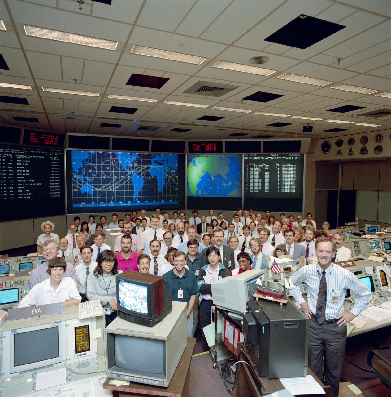
S92-36606 (20 May 1992) --- STS-49 Endeavour, Orbiter Vehicle (OV) 105, Planning Team with Flight Director (FD) James M. Heflin, Jr. (front right next to ship model) poses in Johnson Space Center?s (JSC) Mission Control Center (MCC) Bldg 30 Flight Control Room (FCR). The group stands in front of visual displays projecting STS-49 data and ground track map.
Members of NASA’s Landing and Recovery Team review wave data during Underway Recovery Test-8 off the coast of California. By tracking wave direction and length, the team will ensure a smoother recovery of the Orion spacecraft into the well deck of a Navy ship. During the test, the team practiced to ensure recovery procedure timelines are validated as NASA plans to send Artemis I around the Moon and splashdown in the Pacific Ocean.
ISS045E033806 (09/25/2015) --- NASA astronaut Kjell Lindgren loads a deployer device filled with 16 CubeSats into a small airlock in the Japanese Kibo Module on the International Space Station. Among the 16 satellites are 14 Dove satellites from Planet Labs that will be used for Earth observation, one for testing space based radios and another that will be used to track ships on the open ocean.
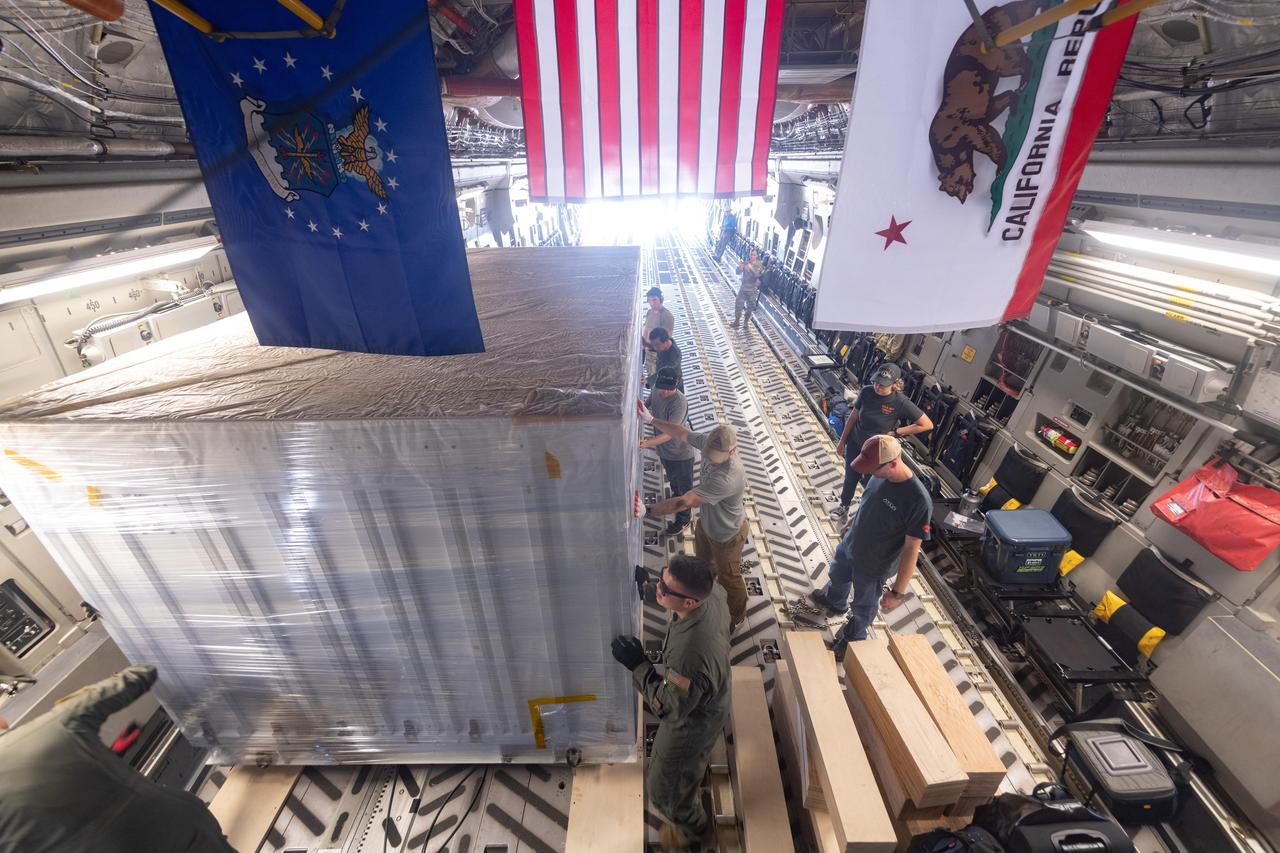
On June 27, 2021, teams from NASA's Jet Propulsion Laboratory in Southern California and the March Air Reserve Base in Riverside County, California, loaded the scientific heart of the Surface Water and Ocean Topography (SWOT) mission into a C-17 airplane. The hardware – which includes research instruments – was headed to a clean room facility near Cannes, France, where engineers and technicians completed assembly of the satellite over the next year. The satellite was subsequently shipped back to California for its December 2022 launch from Vandenberg Space Force Base. SWOT will make global surveys of the water on Earth's surface. By measuring its height, researchers can track the volume and location of the finite resource around the world. The data will help with monitoring changes in floodplains and wetlands, measure how much fresh water flows into and out of lakes and rivers and back to the ocean, and track regional shifts in sea level. https://photojournal.jpl.nasa.gov/catalog/PIA25624
On June 27, 2021, teams from NASA's Jet Propulsion Laboratory in Southern California and the March Air Reserve Base in Riverside County, California, loaded the scientific heart of the Surface Water and Ocean Topography (SWOT) mission into a C-17 airplane. The hardware – which includes research instruments – was headed to a clean room facility near Cannes, France, where engineers and technicians completed assembly of the satellite over the next year. The satellite was subsequently shipped back to California for its December 2022 launch from Vandenberg Space Force Base. SWOT will make global surveys of the water on Earth's surface. By measuring its height, researchers can track the volume and location of the finite resource around the world. The data will help with monitoring changes in floodplains and wetlands, measure how much fresh water flows into and out of lakes and rivers and back to the ocean, and track regional shifts in sea level. https://photojournal.jpl.nasa.gov/catalog/PIA25625
KENNEDY SPACE CENTER, FLA. - An X-band Doppler radar array is being prepared for lifting onto the Liberty Star, one of the two SRB Retrieval Ships, at Hangar AF at Cape Canaveral Air Force Station. The radar will be used for tracking support on NASA’s Return to Flight mission, STS-114, on Space Shuttle Discovery. Launch is targeted for May 15 with a launch window that extends to June 3. During its 12-day mission, Discovery’s seven-member crew will test new hardware and techniques to improve Shuttle safety, as well as deliver supplies to the International Space Station.

At Port Canaveral in Florida, a United Launch Alliance Atlas V rocket booster is transported from the company's Mariner ship to the Atlas Spaceflight Operations Center at Cape Canaveral Air Force Station. The rocket is scheduled to launch the Tracking and Data Relay Satellite, TDRS-M. It will be the latest spacecraft destined for the agency's constellation of communications satellites that allows nearly continuous contact with orbiting spacecraft ranging from the International Space Station and Hubble Space Telescope to the array of scientific observatories. Liftoff atop the ULA Atlas V rocket is scheduled to take place from Cape Canaveral's Space Launch Complex 41 on Aug. 3, 2017 at 9:02 a.m. EDT.
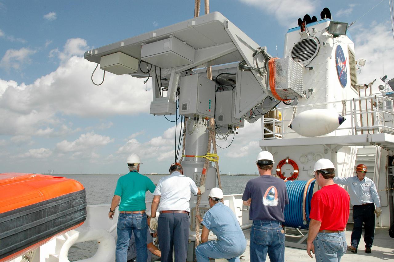
KENNEDY SPACE CENTER, FLA. - At Hangar AF at Cape Canaveral Air Force Station, workers on the Liberty Star, one of the two SRB Retrieval Ships, oversee the safe placement of an X-band Doppler radar array onto the deck. The radar will be used for tracking support on NASA’s Return to Flight mission, STS-114, on Space Shuttle Discovery. Launch is targeted for May 15 with a launch window that extends to June 3. During its 12-day mission, Discovery’s seven-member crew will test new hardware and techniques to improve Shuttle safety, as well as deliver supplies to the International Space Station.
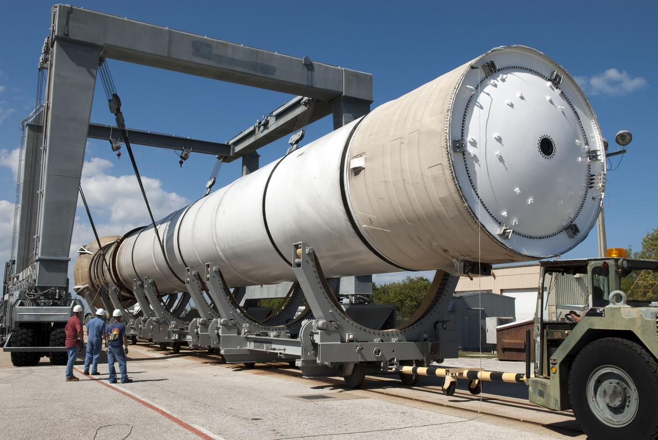
KENNEDY SPACE CENTER, FLA. - At the Boeing Delta Operations Center, a crane lifts the top off the shipping container with the Boeing Delta IV second stage inside. The Delta IV rocket will be used for the 2005 launching of the GOES-N weather satellite for NASA and NOAA (National Oceanic and Atmospheric Administration). The first in a series of three advanced weather satellites including GOES-O and GOES-P, the GOES-N will provide continuous monitoring necessary for intensive data analysis. It will provide a constant vigil for the atmospheric “triggers” of severe weather conditions such as tornadoes, flash floods, hail storms and hurricanes. When these conditions develop, GOES-N will be able to monitor storm development and track their movements.
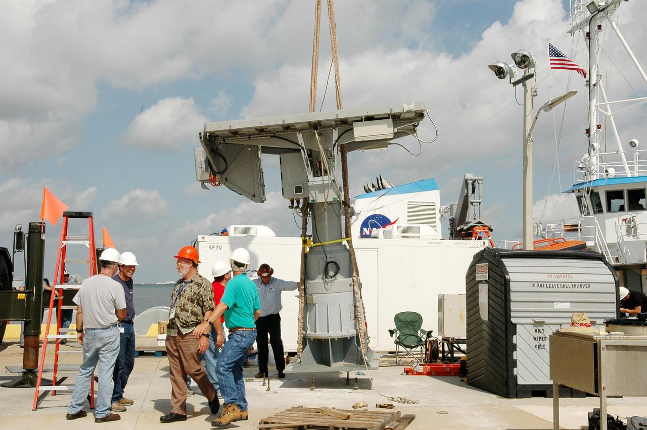
KENNEDY SPACE CENTER, FLA. - An X-band Doppler radar array is ready for lifting onto the Liberty Star, one of the two SRB Retrieval Ships, at Hangar AF at Cape Canaveral Air Force Station. The radar will be used for tracking support on NASA’s Return to Flight mission, STS-114, on Space Shuttle Discovery. Launch is targeted for May 15 with a launch window that extends to June 3. During its 12-day mission, Discovery’s seven-member crew will test new hardware and techniques to improve Shuttle safety, as well as deliver supplies to the International Space Station.
At Port Canaveral in Florida, a United Launch Alliance Centaur uppoer stage is transported from the company's Mariner ship to the Atlas Spaceflight Operations Center at Cape Canaveral Air Force Station. The rocket is scheduled to launch the Tracking and Data Relay Satellite, TDRS-M. It will be the latest spacecraft destined for the agency's constellation of communications satellites that allows nearly continuous contact with orbiting spacecraft ranging from the International Space Station and Hubble Space Telescope to the array of scientific observatories. Liftoff atop the ULA Atlas V rocket is scheduled to take place from Cape Canaveral's Space Launch Complex 41 on Aug. 3, 2017 at 9:02 a.m. EDT.
At Port Canaveral in Florida, a United Launch Alliance Atlas V rocket booster is transported from the company's Mariner ship to the Atlas Spaceflight Operations Center at Cape Canaveral Air Force Station. The rocket is scheduled to launch the Tracking and Data Relay Satellite, TDRS-M. It will be the latest spacecraft destined for the agency's constellation of communications satellites that allows nearly continuous contact with orbiting spacecraft ranging from the International Space Station and Hubble Space Telescope to the array of scientific observatories. Liftoff atop the ULA Atlas V rocket is scheduled to take place from Cape Canaveral's Space Launch Complex 41 on Aug. 3, 2017 at 9:02 a.m. EDT.
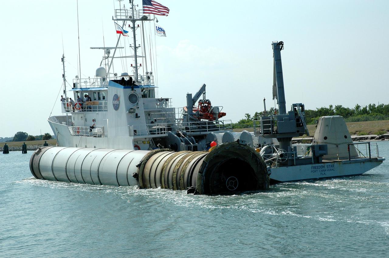
KENNEDY SPACE CENTER, FLA. - Kennedy Space Center employees on the solid rocket booster recovery ship Freedom Star acknowledge photographers awaiting their arrival at Port Canaveral. The ship, with a spent solid rocket booster (SRB) from the STS-114 launch on July 26 in tow, is headed for Hangar AF on Cape Canaveral Air Force Station. The SRBs are the largest solid propellant motors ever flown and the first designed for reuse. After a Shuttle is launched, the SRBs are jettisoned at two minutes, seven seconds into the flight. At six minutes and 44 seconds after liftoff, the spent SRBs, weighing about 165,000 lb., have slowed their descent speed to about 62 mph and splashdown takes place in a predetermined area. They are retrieved from the Atlantic Ocean by special recovery vessels and returned for refurbishment and eventual reuse on future Shuttle flights. Once at Hangar AF, the SRBs are unloaded onto a hoisting slip and mobile gantry cranes lift them onto tracked dollies where they are safed and undergo their first washing.
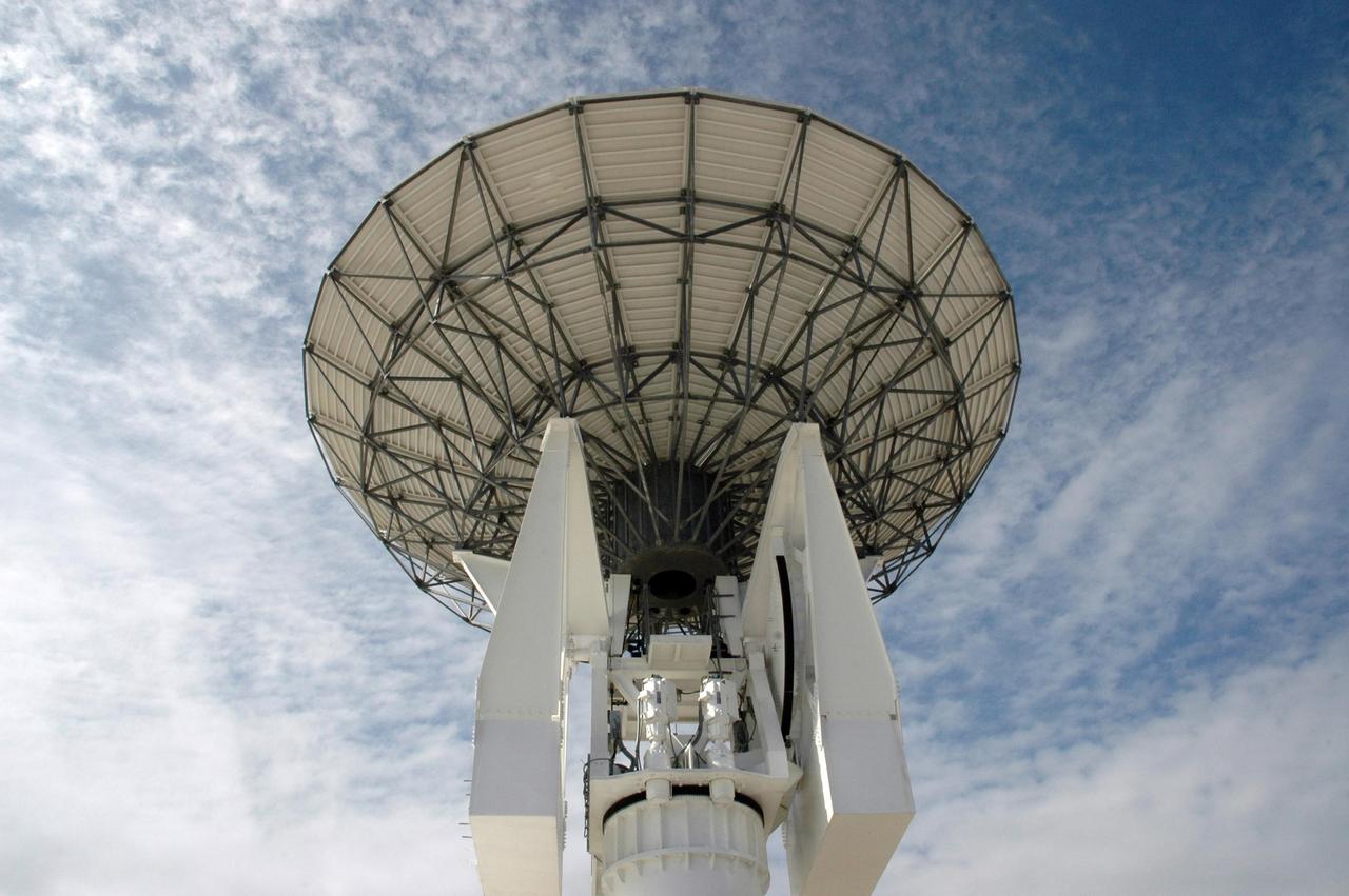
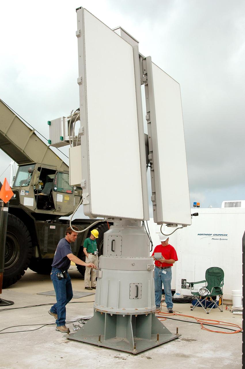
KENNEDY SPACE CENTER, FLA. - Stretching into the cloud-streaked sky is this new C-band, 3 megawatt radar with a 50-foot dish antenna recently installed on north Kennedy Space Center. It is one of the largest of its kind in the world, providing higher definition imagery than has ever been available before. Working in concert with two new NASA-owned X-band radars mounted on the solid rocket booster retrieval ships, tracking the space shuttle and expendable launch vehicles with this new capability will provide more detail than NASA has ever observed by radar before. The first use of this C-band radar will be for the launch of the Atlas V rocket sending the New Horizons probe toward Pluto. The radar is operated under a NASA contract with the U.S. Navy who owns the radar.
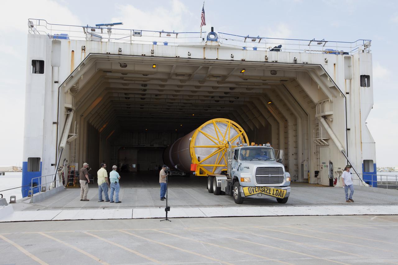
CAPE CANAVERAL, Fla. -- At the Solid Rocket Booster Disassembly Facility at Hangar AF on Cape Canaveral Air Force Station in Florida, one of the solid rocket boosters used during space shuttle Discovery's STS-133 launch is moved for processing atop a tracked dolly. Following the launch from NASA Kennedy Space Center's Launch Pad 39A on Feb. 24, the shuttle's two boosters fell into the Atlantic Ocean. There, the booster casings and associated flight hardware were recovered by Liberty Star and Freedom Star. The boosters impact the Atlantic about seven minutes after liftoff and the retrieval ships are stationed about 10 miles from the impact area at the time of splashdown. After the spent segments are processed, they will be transported to Utah, where they will be refurbished and stored, if needed. Photo credit: NASA/Jim Grossmann
KENNEDY SPACE CENTER, FLA. - At the Boeing Delta Operations Center, a crane moves to the ground the top of the shipping container at right. The container holds the Boeing Delta IV second stage inside. The Delta IV rocket will be used for the 2005 launching of the GOES-N weather satellite for NASA and NOAA (National Oceanic and Atmospheric Administration). The first in a series of three advanced weather satellites including GOES-O and GOES-P, the GOES-N will provide continuous monitoring necessary for intensive data analysis. It will provide a constant vigil for the atmospheric “triggers” of severe weather conditions such as tornadoes, flash floods, hail storms and hurricanes. When these conditions develop, GOES-N will be able to monitor storm development and track their movements.
KENNEDY SPACE CENTER, FLA. - A Boeing Delta IV first stage spans the entire roadway as it approaches a Security gate at Cape Canaveral Air Force Station. Two rockets were shipped by barge to Port Canaveral and offloaded onto an Elevating Platform Transporter for the journey to the Horizontal Integration Facility at Launch Complex 37, CCAFS. The rocket will be used for the December launching of the GOES-N weather satellite for NASA and NOAA. The GOES-N is the first in a series of three advanced weather satellites including GOES-O and GOES-P. This satellite will provide continuous monitoring necessary for intensive data analysis. It will provide a constant vigil for the atmospheric “triggers” of severe weather conditions such as tornadoes, flash floods, hail storms and hurricanes. When these conditions develop, GOES-N will be able to monitor storm development and track their movements.

KENNEDY SPACE CENTER, FLA. - Chuck Demming, with Northrop Grumman, works the console responsible for operation of the C-band, 3 megawatt radar and 50-foot dish antenna recently installed on north Kennedy Space Center. The radar is is one of the largest of its kind in the world, providing higher definition imagery than has ever been available before. Working in concert with two new NASA-owned X-band radars mounted on the solid rocket booster retrieval ships, tracking the space shuttle and expendable launch vehicles with this new capability will provide more detail than NASA has ever observed by radar before. The first use of this C-band radar will be for the launch of the Atlas V rocket sending the New Horizons probe toward Pluto. The radar is operated under a NASA contract with the U.S. Navy, who owns the radar. Photo credit: NASA/George Shelton/Demitrius Gerondidakas
At Port Canaveral in Florida, a United Launch Alliance Atlas V rocket booster and Centaur upper stage are about to be transported from the company's Mariner ship to the Atlas Spaceflight Operations Center at Cape Canaveral Air Force Station. The rocket is scheduled to launch the Tracking and Data Relay Satellite, TDRS-M. It will be the latest spacecraft destined for the agency's constellation of communications satellites that allows nearly continuous contact with orbiting spacecraft ranging from the International Space Station and Hubble Space Telescope to the array of scientific observatories. Liftoff atop the ULA Atlas V rocket is scheduled to take place from Cape Canaveral's Space Launch Complex 41 on Aug. 3, 2017 at 9:02 a.m. EDT.
CAPE CANAVERAL, Fla. -- At the Solid Rocket Booster Disassembly Facility at Hangar AF on Cape Canaveral Air Force Station in Florida, one of the solid rocket boosters used during space shuttle Discovery's STS-133 launch is moved to a tracked dolly for processing. Following the launch from NASA Kennedy Space Center's Launch Pad 39A on Feb. 24, the shuttle's two boosters fell into the Atlantic Ocean. There, the booster casings and associated flight hardware were recovered by Liberty Star and Freedom Star. The boosters impact the Atlantic about seven minutes after liftoff and the retrieval ships are stationed about 10 miles from the impact area at the time of splashdown. After the spent segments are processed, they will be transported to Utah, where they will be refurbished and stored, if needed. Photo credit: NASA/Jim Grossmann

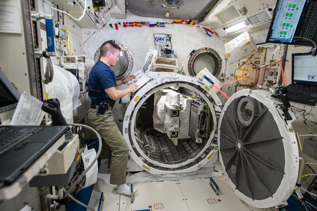
S129-E-007227 (21 Nov. 2009) --- Astronaut Randy Bresnik (near the Columbus laboratory), STS-129 mission specialist, participates in the mission's second session of extravehicular activity (EVA) as construction and maintenance continue on the International Space Station. During the six-hour, eight-minute spacewalk, Bresnik and astronaut Mike Foreman (out of frame), mission specialist, installed a Grappling Adaptor to On-Orbit Railing Assembly, or GATOR, on the Columbus laboratory. GATOR contains a ship-tracking antenna system and a HAM radio antenna. They relocated a floating potential measurement unit that gauges electric charges that build up on the station, deployed a Payload Attach System on the space-facing side of the Starboard 3 truss segment and installed a wireless video system that allows spacewalkers to transmit video to the station and relay it to Earth.
CAPE CANAVERAL, Fla. – At the Solid Rocket Booster Disassembly Facility at Hangar AF on Cape Canaveral Air Force Station in Florida, one of the solid rocket boosters used during space shuttle Atlantis' STS-132 launch, atop a tracked dolly, undergoes its first washing. The booster was used during space shuttle Atlantis' STS-132 launch from NASA Kennedy Space Center's Launch Pad 39A on May 14. The shuttle’s two solid rocket boosters' casings and associated flight hardware are recovered from the Atlantic Ocean shortly after launch by special recovery ships, the Liberty Star and Freedom Star, and returned for refurbishment and reuse on future shuttle flights, if needed. Hangar AF was originally used to support Project Mercury, the first U.S. human space program. Photo credit: NASA_Jim Grossmann
CAPE CANAVERAL, Fla. -- At the Solid Rocket Booster Disassembly Facility at Hangar AF on Cape Canaveral Air Force Station in Florida, one of the solid rocket boosters used during space shuttle Discovery's STS-133 launch is moved to a tracked dolly for processing. Following the launch from NASA Kennedy Space Center's Launch Pad 39A on Feb. 24, the shuttle's two boosters fell into the Atlantic Ocean. There, the booster casings and associated flight hardware were recovered by Liberty Star and Freedom Star. The boosters impact the Atlantic about seven minutes after liftoff and the retrieval ships are stationed about 10 miles from the impact area at the time of splashdown. After the spent segments are processed, they will be transported to Utah, where they will be refurbished and stored, if needed. Photo credit: NASA/Jim Grossmann
KENNEDY SPACE CENTER, FLA. - This new C-band, 3 megawatt radar with a 50-foot dish antenna has recently been installed on north Kennedy Space Center. It is one of the largest of its kind in the world, providing higher definition imagery than has ever been available before. Working in concert with two new NASA-owned X-band radars mounted on the solid rocket booster retrieval ships, tracking the space shuttle and expendable launch vehicles with this new capability will provide more detail than NASA has ever observed by radar before. The first use of this C-band radar will be for the launch of the Atlas V rocket sending the New Horizons probe toward Pluto. The radar is operated under a NASA contract with the U.S. Navy who owns the radar.
KENNEDY SPACE CENTER, FLA. - A Security escort leads the way as this Boeing Delta IV first stage heads to the Horizontal Integration Facility at Launch Complex 37, Cape Canaveral Air Force Station. Two of the launch pads on Cape Canaveral’s coast can be seen in the background. Two rockets were shipped by barge from Decatur, Ala., to Port Canaveral and offloaded onto Elevating Platform Transporters. A Boeing Delta IV will be used for the December launching of the GOES-N weather satellite for NASA and NOAA. The GOES-N is the first in a series of three advanced weather satellites including GOES-O and GOES-P. This satellite will provide continuous monitoring necessary for intensive data analysis. It will provide a constant vigil for the atmospheric “triggers” of severe weather conditions such as tornadoes, flash floods, hail storms and hurricanes. When these conditions develop, GOES-N will be able to monitor storm development and track their movements.

KENNEDY SPACE CENTER, FLA. - This new C-band, 3 megawatt radar with a 50-foot dish antenna has recently been installed on north Kennedy Space Center. It is one of the largest of its kind in the world, providing higher definition imagery than has ever been available before. Working in concert with two new NASA-owned X-band radars mounted on the solid rocket booster retrieval ships, tracking the space shuttle and expendable launch vehicles with this new capability will provide more detail than NASA has ever observed by radar before. The first use of this C-band radar will be for the launch of the Atlas V rocket sending the New Horizons probe toward Pluto. The radar is operated under a NASA contract with the U.S. Navy who owns the radar.

KENNEDY SPACE CENTER, FLA. - This new C-band, 3 megawatt radar with a 50-foot dish antenna has recently been installed on north Kennedy Space Center. It is one of the largest of its kind in the world, providing higher definition imagery than has ever been available before. Working in concert with two new NASA-owned X-band radars mounted on the solid rocket booster retrieval ships, tracking the space shuttle and expendable launch vehicles with this new capability will provide more detail than NASA has ever observed by radar before. The first use of this C-band radar will be for the launch of the Atlas V rocket sending the New Horizons probe toward Pluto. The radar is operated under a NASA contract with the U.S. Navy who owns the radar.
CAPE CANAVERAL, Fla. -- Workers at the Solid Rocket Booster Disassembly Facility at Hangar AF on Cape Canaveral Air Force Station in Florida, inspect the left spent booster used during space shuttle Discovery's final launch, after it was lowered onto a tracked dolly for processing. The shuttle's two solid rocket booster casings and associated flight hardware are recovered in the Atlantic Ocean after every launch by Freedom Star and Liberty Star. The boosters impact the Atlantic about seven minutes after liftoff and the retrieval ships are stationed about 10 miles from the impact area at the time of splashdown. After the spent segments are processed, they will be transported to Utah, where they will be refurbished and stored, if needed. Photo credit: NASA/Jim Grossmann
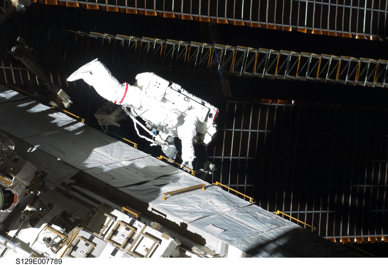
S129-E-007789 (21 Nov. 2009) --- Astronaut Mike Foreman, STS-129 mission specialist, participates in the mission's second session of extravehicular activity (EVA) as construction and maintenance continue on the International Space Station. During the six-hour, eight-minute spacewalk, Foreman and astronaut Randy Bresnik (out of frame), mission specialist, installed a Grappling Adaptor to On-Orbit Railing Assembly, or GATOR, on the Columbus laboratory. GATOR contains a ship-tracking antenna system and a HAM radio antenna. They relocated a floating potential measurement unit that gauges electric charges that build up on the station, deployed a Payload Attach System on the space-facing side of the Starboard 3 truss segment and installed a wireless video system that allows spacewalkers to transmit video to the station and relay it to Earth.
KENNEDY SPACE CENTER, FLA. - The solid rocket booster recovery ship Freedom Star makes its way through Port Canaveral with a spent solid rocket booster (SRB) from the STS-114 launch on July 26 in tow. The SRBs are the largest solid propellant motors ever flown and the first designed for reuse. After a Shuttle is launched, the SRBs are jettisoned at two minutes, seven seconds into the flight. At six minutes and 44 seconds after liftoff, the spent SRBs, weighing about 165,000 lb., have slowed their descent speed to about 62 mph and splashdown takes place in a predetermined area. They are retrieved from the Atlantic Ocean by special recovery vessels and returned for refurbishment and eventual reuse on future Shuttle flights. Once at Hangar AF, the SRBs are unloaded onto a hoisting slip and mobile gantry cranes lift them onto tracked dollies where they are safed and undergo their first washing.
KENNEDY SPACE CENTER, FLA. - Two Boeing Delta IV first stages are being shipped on the Delta Mariner, heading for Cape Canaveral Air Force Station. After arrival at Port Canaveral, they will be transported to the Horizontal Integration Facility at Launch Complex 37, CCAFS. The rocket will be used for the December launching of the GOES-N weather satellite for NASA and NOAA. The GOES-N is the first in a series of three advanced weather satellites including GOES-O and GOES-P. This satellite will provide continuous monitoring necessary for intensive data analysis. It will provide a constant vigil for the atmospheric “triggers” of severe weather conditions such as tornadoes, flash floods, hail storms and hurricanes. When these conditions develop, GOES-N will be able to monitor storm development and track their movements.
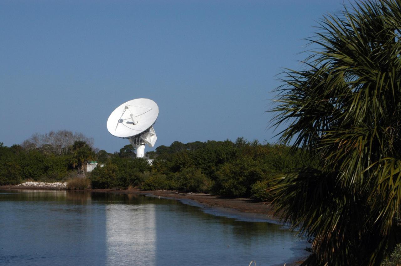
KENNEDY SPACE CENTER, FLA. - This new C-band, 3 megawatt radar with a 50-foot dish antenna reflects on the marsh water nearby. The antenna has recently been installed on north Kennedy Space Center. It is one of the largest of its kind in the world, providing higher definition imagery than has ever been available before. Working in concert with two new NASA-owned X-band radars mounted on the solid rocket booster retrieval ships, tracking the space shuttle and expendable launch vehicles with this new capability will provide more detail than NASA has ever observed by radar before. The first use of this C-band radar will be for the launch of the Atlas V rocket sending the New Horizons probe toward Pluto. The radar is operated under a NASA contract with the U.S. Navy who owns the radar.
CAPE CANAVERAL, Fla. -- At the Solid Rocket Booster Disassembly Facility at Hangar AF on Cape Canaveral Air Force Station in Florida, the left spent booster, used during space shuttle Discovery's final launch, is lowered onto a tracked dolly for processing. The shuttle's two solid rocket booster casings and associated flight hardware are recovered in the Atlantic Ocean after every launch by Freedom Star and Liberty Star. The boosters impact the Atlantic about seven minutes after liftoff and the retrieval ships are stationed about 10 miles from the impact area at the time of splashdown. After the spent segments are processed, they will be transported to Utah, where they will be refurbished and stored, if needed. Photo credit: NASA/Jim Grossmann
KENNEDY SPACE CENTER, FLA. - The solid rocket booster recovery ship Freedom Star enters Port Canaveral with a spent solid rocket booster (SRB) from the STS-114 launch on July 26 in tow. The SRBs are the largest solid propellant motors ever flown and the first designed for reuse. After a Shuttle is launched, the SRBs are jettisoned at two minutes, seven seconds into the flight. At six minutes and 44 seconds after liftoff, the spent SRBs, weighing about 165,000 lb., have slowed their descent speed to about 62 mph and splashdown takes place in a predetermined area. They are retrieved from the Atlantic Ocean by special recovery vessels and returned for refurbishment and eventual reuse on future Shuttle flights. Once at Hangar AF, the SRBs are unloaded onto a hoisting slip and mobile gantry cranes lift them onto tracked dollies where they are safed and undergo their first washing.
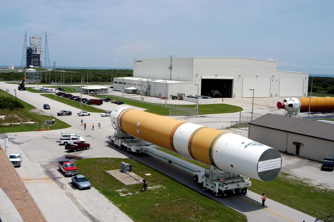
KENNEDY SPACE CENTER, FLA. - Two Boeing Delta IV first stages head to the Horizontal Integration Facility (upper right) at Launch Complex 37, Cape Canaveral Air Force Station. The rockets were shipped by barge from Decatur, Ala., to Port Canaveral and offloaded onto Elevating Platform Transporters. A Boeing Delta IV will be used for the December launching of the GOES-N weather satellite for NASA and NOAA. The GOES-N is the first in a series of three advanced weather satellites including GOES-O and GOES-P. This satellite will provide continuous monitoring necessary for intensive data analysis. It will provide a constant vigil for the atmospheric “triggers” of severe weather conditions such as tornadoes, flash floods, hail storms and hurricanes. When these conditions develop, GOES-N will be able to monitor storm development and track their movements.
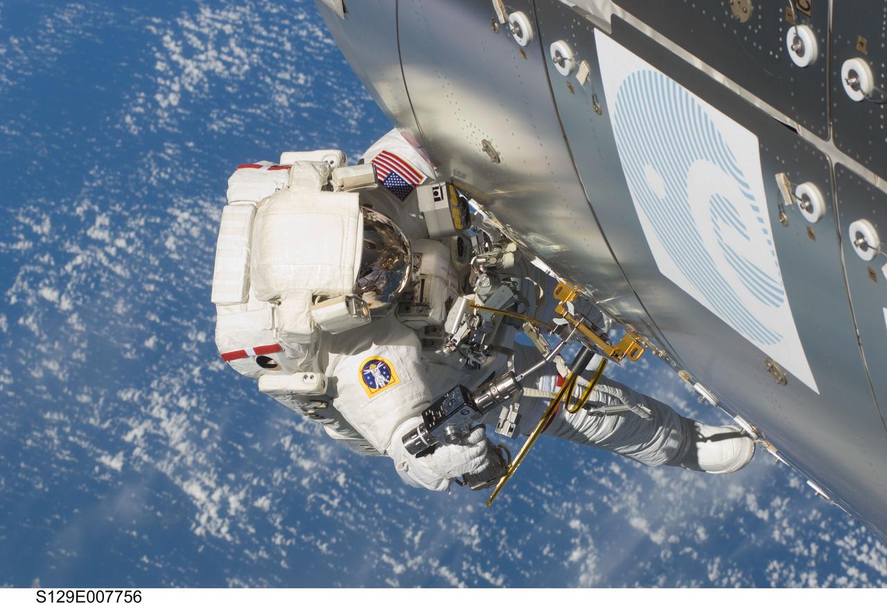
S129-E-007756 (21 Nov. 2009) --- Astronaut Randy Bresnik (near the Columbus laboratory), STS-129 mission specialist, participates in the mission's second session of extravehicular activity (EVA) as construction and maintenance continue on the International Space Station. During the six-hour, eight-minute spacewalk, Bresnik and astronaut Mike Foreman (out of frame), mission specialist, installed a Grappling Adaptor to On-Orbit Railing Assembly, or GATOR, on the Columbus laboratory. GATOR contains a ship-tracking antenna system and a HAM radio antenna. They relocated a floating potential measurement unit that gauges electric charges that build up on the station, deployed a Payload Attach System on the space-facing side of the Starboard 3 truss segment and installed a wireless video system that allows spacewalkers to transmit video to the station and relay it to Earth.
KENNEDY SPACE CENTER, FLA. - The first of two Boeing Delta IV first stages is moved inside the Horizontal Integration Facility at Launch Complex 37, Cape Canaveral Air Force Station. The rockets were shipped by barge from Decatur, Ala., to Port Canaveral and offloaded onto Elevating Platform Transporters. . A Boeing Delta IV will be used for the December launching of the GOES-N weather satellite for NASA and NOAA. The GOES-N is the first in a series of three advanced weather satellites including GOES-O and GOES-P. This satellite will provide continuous monitoring necessary for intensive data analysis. It will provide a constant vigil for the atmospheric “triggers” of severe weather conditions such as tornadoes, flash floods, hail storms and hurricanes. When these conditions develop, GOES-N will be able to monitor storm development and track their movements.
KENNEDY SPACE CENTER, FLA. - A Boeing Delta IV first stage, called a Common Booster Core, is offloaded from the Delta Mariner at Port Canaveral. It is one of two shipped from Decatur, Ala., and is being transported to the Horizontal Integration Facility at Launch Complex 37, Cape Canaveral Air Force Station. The rocket will be used for the December launching of the GOES-N weather satellite for NASA and NOAA. The GOES-N is the first in a series of three advanced weather satellites including GOES-O and GOES-P. This satellite will provide continuous monitoring necessary for intensive data analysis. It will provide a constant vigil for the atmospheric “triggers” of severe weather conditions such as tornadoes, flash floods, hail storms and hurricanes. When these conditions develop, GOES-N will be able to monitor storm development and track their movements.
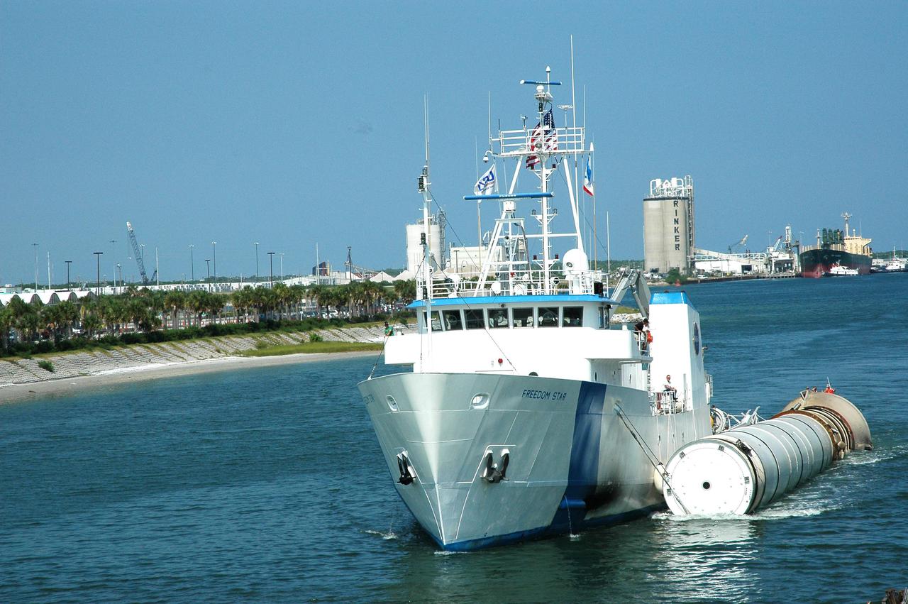
KENNEDY SPACE CENTER, FLA. - The solid rocket booster recovery ship Freedom Star travels through Port Canaveral with a spent solid rocket booster (SRB) from the STS-114 launch on July 26 in tow. The SRBs are the largest solid propellant motors ever flown and the first designed for reuse. After a Shuttle is launched, the SRBs are jettisoned at two minutes, seven seconds into the flight. At six minutes and 44 seconds after liftoff, the spent SRBs, weighing about 165,000 lb., have slowed their descent speed to about 62 mph and splashdown takes place in a predetermined area. They are retrieved from the Atlantic Ocean by special recovery vessels and returned for refurbishment and eventual reuse on future Shuttle flights. Once at Hangar AF, the SRBs are unloaded onto a hoisting slip and mobile gantry cranes lift them onto tracked dollies where they are safed and undergo their first washing.
CAPE CANAVERAL, Fla. -- At the Solid Rocket Booster Disassembly Facility at Hangar AF on Cape Canaveral Air Force Station in Florida, one of the solid rocket boosters used during space shuttle Discovery's STS-133 launch is moved to a tracked dolly for processing. Following the launch from NASA Kennedy Space Center's Launch Pad 39A on Feb. 24, the shuttle's two boosters fell into the Atlantic Ocean. There, the booster casings and associated flight hardware were recovered by Liberty Star and Freedom Star. The boosters impact the Atlantic about seven minutes after liftoff and the retrieval ships are stationed about 10 miles from the impact area at the time of splashdown. After the spent segments are processed, they will be transported to Utah, where they will be refurbished and stored, if needed. Photo credit: NASA/Jim Grossmann

KENNEDY SPACE CENTER, FLA. - This new C-band, 3 megawatt radar with a 50-foot dish antenna has recently been installed on north Kennedy Space Center. It is one of the largest of its kind in the world, providing higher definition imagery than has ever been available before. Working in concert with two new NASA-owned X-band radars mounted on the solid rocket booster retrieval ships, tracking the space shuttle and expendable launch vehicles with this new capability will provide more detail than NASA has ever observed by radar before. The first use of this C-band radar will be for the launch of the Atlas V rocket sending the New Horizons probe toward Pluto. The radar is operated under a NASA contract with the U.S. Navy who owns the radar.
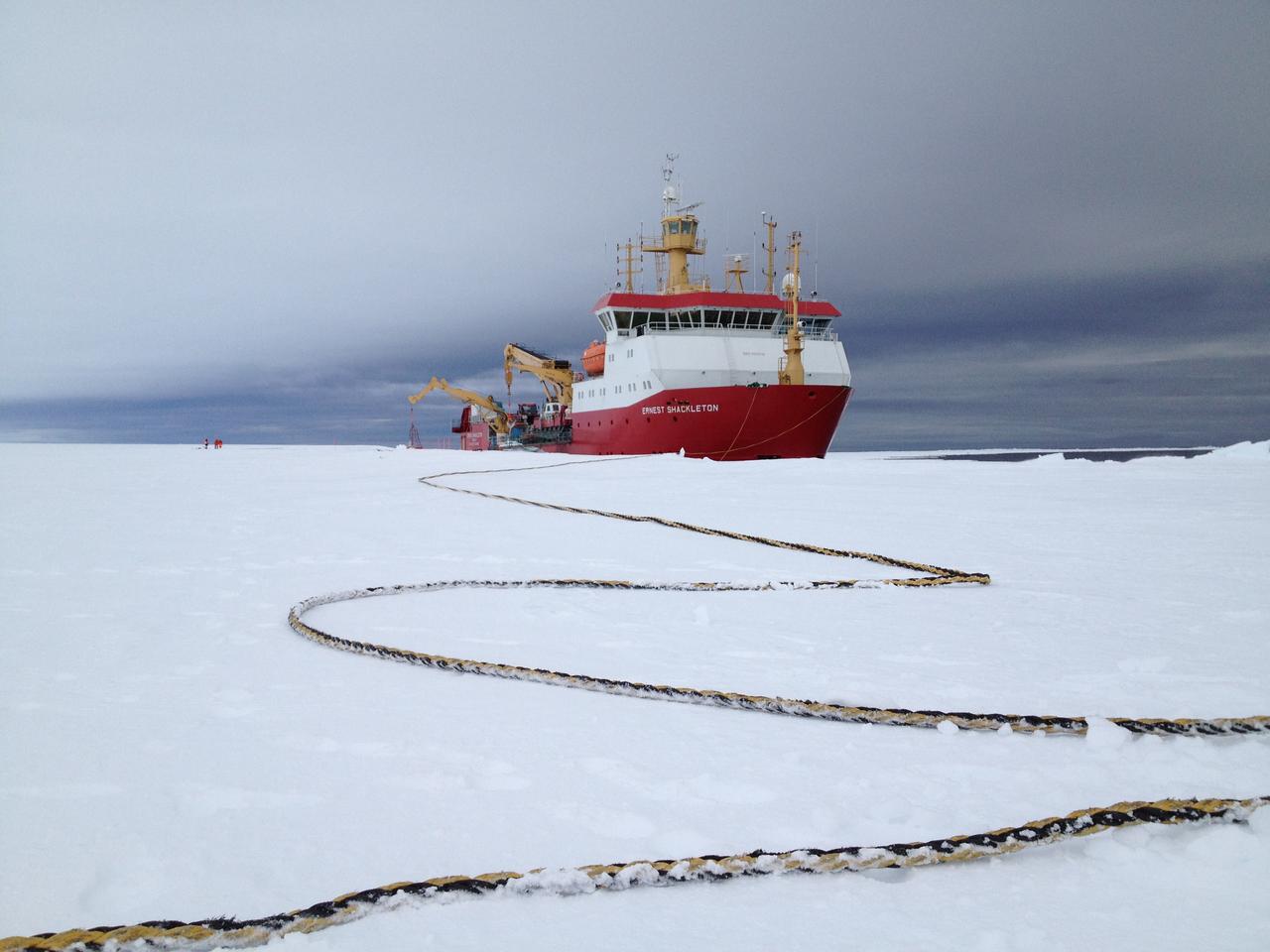
Arrival of the RRS Ernest Shackleton near Halley Research Station in Antarctica. The Shackleton is the regular resupply ship for the station and it also brought in some of the BARREL team scientists. The long tether is for the ship’s mooring. Credit: NASA --- In Antarctica in January, 2013 – the summer at the South Pole – scientists launched 20 balloons up into the air to study an enduring mystery of space weather: when the giant radiation belts surrounding Earth lose material, where do the extra particles actually go? The mission is called BARREL (Balloon Array for Radiation belt Relativistic Electron Losses) and it is led by physicist Robyn Millan of Dartmouth College in Hanover, NH. Millan provided photographs from the team’s time in Antarctica. The team launched a balloon every day or two into the circumpolar winds that circulate around the pole. Each balloon floated for anywhere from 3 to 40 days, measuring X-rays produced by fast-moving electrons high up in the atmosphere. BARREL works hand in hand with another NASA mission called the Van Allen Probes, which travels through the Van Allen radiation belts surrounding Earth. The belts wax and wane over time in response to incoming energy and material from the sun, sometimes intensifying the radiation through which satellites must travel. Scientists wish to understand this process better, and even provide forecasts of this space weather, in order to protect our spacecraft. As the Van Allen Probes were observing what was happening in the belts, BARREL tracked electrons that precipitated out of the belts and hurtled down Earth’s magnetic field lines toward the poles. By comparing data, scientists will be able to track how what’s happening in the belts correlates to the loss of particles – information that can help us understand this mysterious, dynamic region that can impact spacecraft. Having launched balloons in early 2013, the team is back at home building the next set of payloads. They will launch 20 more balloons in 2014. <b><a href="http://www.nasa.gov/audience/formedia/features/MP_Photo_Guidelines.html" rel="nofollow">NASA image use policy.</a></b> <b><a href="http://www.nasa.gov/centers/goddard/home/index.html" rel="nofollow">NASA Goddard Space Flight Center</a></b> enables NASA’s mission through four scientific endeavors: Earth Science, Heliophysics, Solar System Exploration, and Astrophysics. Goddard plays a leading role in NASA’s accomplishments by contributing compelling scientific knowledge to advance the Agency’s mission. <b>Follow us on <a href="http://twitter.com/NASA_GoddardPix" rel="nofollow">Twitter</a></b> <b>Like us on <a href="http://www.facebook.com/pages/Greenbelt-MD/NASA-Goddard/395013845897?ref=tsd" rel="nofollow">Facebook</a></b> <b>Find us on <a href="http://instagram.com/nasagoddard?vm=grid" rel="nofollow">Instagram</a></b>
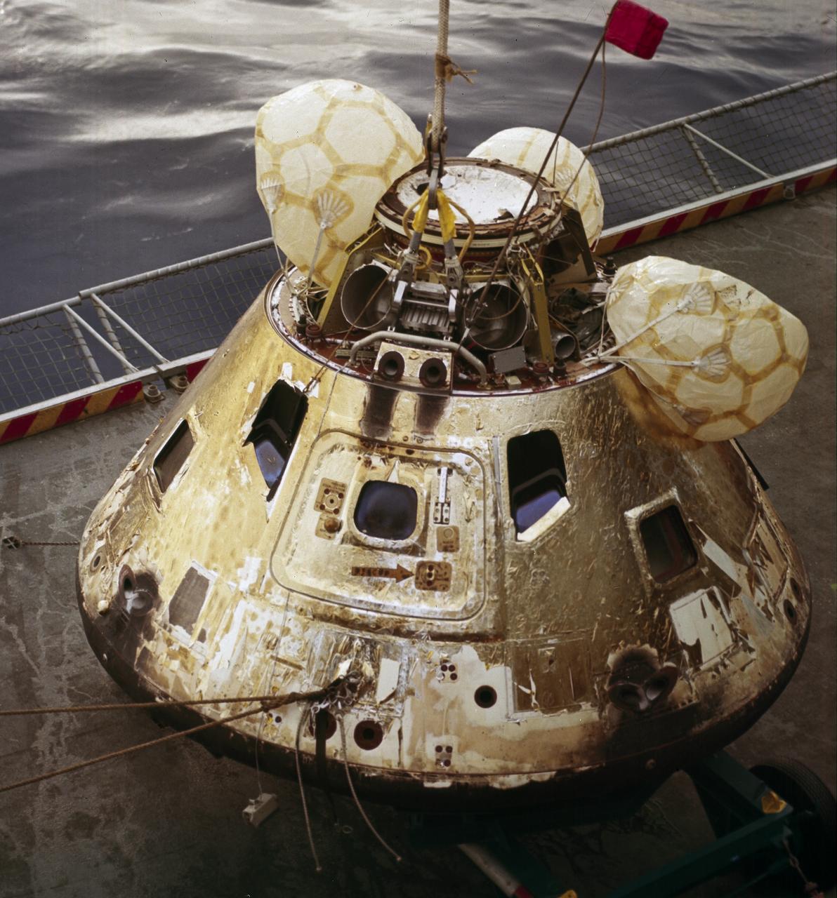
This is a photograph of the Apollo 8 Capsule being hoisted onto the recovery ship following splashdown on December 27, 1968. The first manned Apollo mission to escape Earth’s gravity and travel to the lunar vicinity, the Saturn V, SA-503, Apollo 8 mission liftoff occurred seven days prior, on December 21, 1968. Aboard were astronauts William Anders, Lunar Module (LM) Pilot; James Lovell, Command Module (CM) pilot; and Frank Borman, commander. The mission achieved operational experience and tested the Apollo command module systems, including communications, tracking, and life-support, in cis-lunar space and lunar orbit, and allowed evaluation of crew performance on a lunar orbiting mission. The crew photographed the lunar surface, both far side and near side, obtaining information on topography and landmarks as well as other scientific information necessary for future Apollo landings. All systems operated within allowable parameters and all objectives of the mission were achieved.
KENNEDY SPACE CENTER, FLA. - Photographers capture the solid rocket booster recovery ship Freedom Star, with a spent solid rocket booster (SRB) from the STS-114 launch on July 26 in tow, as it makes it way through Port Canaveral to Hangar AF on the Cape Canaveral Air Force Station. The SRBs are the largest solid propellant motors ever flown and the first designed for reuse. After a Shuttle is launched, the SRBs are jettisoned at two minutes, seven seconds into the flight. At six minutes and 44 seconds after liftoff, the spent SRBs, weighing about 165,000 lb., have slowed their descent speed to about 62 mph and splashdown takes place in a predetermined area. They are retrieved from the Atlantic Ocean by special recovery vessels and returned for refurbishment and eventual reuse on future Shuttle flights. Once at Hangar AF, the SRBs are unloaded onto a hoisting slip and mobile gantry cranes lift them onto tracked dollies where they are safed and undergo their first washing.
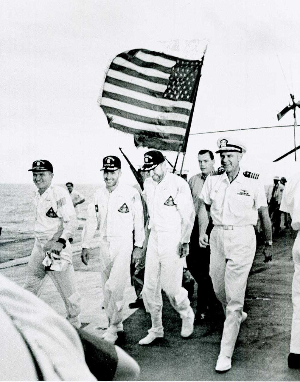
Apollo 8 astronauts and commanding officer of the recovery ship U.S.S. Yorktown walk the red carpet of the flight deck after splashdown recovery in the Pacific Ocean. Apollo 8 served as the first manned lunar orbit mission and the first manned flight of the Saturn V space vehicle, developed by the Marshall Space Flight Center (MSFC). Liftoff occurred on December 21, 1968, carrying astronauts Frank Borman, commander; William Anders, Lunar Module (LM) Pilot; and James Lovell, Command Module (CM) pilot. The three safely returned to Earth on December 27, 1968. The mission achieved operational experience and tested the Apollo command module systems, including communications, tracking, and life-support, in cis-lunar space and lunar orbit, and allowed evaluation of crew performance on a lunar orbiting mission. The crew photographed the lunar surface, both far side and near side, obtaining information on topography and landmarks as well as other scientific information necessary for future Apollo landings. All systems operated within allowable parameters and all objectives of the mission were achieved.
KENNEDY SPACE CENTER, FLA. -- Seen carrying a spent solid rocket booster (SRB) from the STS-87 launch on Nov. 19 is the solid rocket booster recovery ship Liberty Star as it reenters the Hangar AF area at Cape Canaveral Air Station. Hangar AF is a building originally used for Project Mercury, the first U.S. manned space program. The SRBs are the largest solid propellant motors ever flown and the first designed for reuse. After a Shuttle is launched, the SRBs are jettisoned at two minutes, seven seconds into the flight. At six minutes and 44 seconds after liftoff, the spent SRBs, weighing about 165,000 lb., have slowed their descent speed to about 62 mph and splashdown takes place in a predetermined area. They are retrieved from the Atlantic Ocean by special recovery vessels and returned for refurbishment and eventual reuse on future Shuttle flights. Once at Hangar AF, the SRBs are unloaded onto a hoisting slip and mobile gantry cranes lift them onto tracked dollies where they are safed and undergo their first washing
KENNEDY SPACE CENTER, FLA. -- Seen carrying a spent solid rocket booster (SRB) from the STS-87 launch on Nov. 19 is the solid rocket booster recovery ship Liberty Star as it reenters the Hangar AF area at Cape Canaveral Air Station. Hangar AF is a building originally used for Project Mercury, the first U.S. manned space program. The SRBs are the largest solid propellant motors ever flown and the first designed for reuse. After a Shuttle is launched, the SRBs are jettisoned at two minutes, seven seconds into the flight. At six minutes and 44 seconds after liftoff, the spent SRBs, weighing about 165,000 lb., have slowed their descent speed to about 62 mph and splashdown takes place in a predetermined area. They are retrieved from the Atlantic Ocean by special recovery vessels and returned for refurbishment and eventual reuse on future Shuttle flights. Once at Hangar AF, the SRBs are unloaded onto a hoisting slip and mobile gantry cranes lift them onto tracked dollies where they are safed and undergo their first washing
The new international satellite mission called Surface Water and Ocean Topography (SWOT) — slated for launch in late 2022 — will measure the height of Earth's surface water. The data the spacecraft will collect will help researchers understand and track the volume and location of water around the world. The satellite will assist with monitoring changes in floodplains and wetlands, measuring how much fresh water flows into and out of lakes and rivers and back to the ocean, and tracking regional shifts in sea level at scales never seen before. The satellite will also provide information on small-scale ocean currents that will support real-time marine operations affected by tides, currents, storm surge, sediment transport, and water quality issues. The payload is taking shape in a clean room at NASA's Jet Propulsion Laboratory in Southern California before being shipped to France. There, technicians and engineers from the French space agency Centre National d'Etudes Spatial (CNES), their prime contractor Thales Alenia Space, and JPL will complete the build and prepare the satellite for shipment to its California launch site at Vandenberg Air Force Base. JPL project manager Parag Vaze (pronounced vah-zay) is central to ensuring the handoff to his CNES counterpart Thierry Lafon goes smoothly. SWOT is being jointly developed by NASA and CNES, with contributions from the Canadian Space Agency (CSA) and United Kingdom Space Agency (UKSA). JPL, which is managed for NASA by Caltech in Pasadena, California, leads the U.S. component of the project. For the flight system, NASA is providing the Ka-band Radar Interferometer (KaRIn) instrument, a GPS science receiver, a laser retroreflector, and a two-beam microwave radiometer. CNES is providing the Doppler Orbitography and Radioposition Integrated by Satellite (DORIS) system, nadir altimeter, and the KaRIn RF subsystem (with support from the UKSA). CSA is providing the KaRIn high-power transmitter assembly. NASA is providing associated launch services. https://photojournal.jpl.nasa.gov/catalog/PIA24531
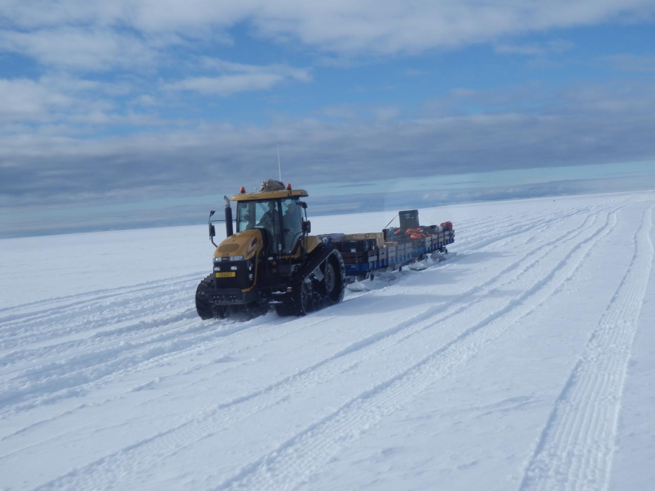
The BARREL cargo on its four-hour journey from the supply ship to the research station. Credit: NASA --- In Antarctica in January, 2013 – the summer at the South Pole – scientists launched 20 balloons up into the air to study an enduring mystery of space weather: when the giant radiation belts surrounding Earth lose material, where do the extra particles actually go? The mission is called BARREL (Balloon Array for Radiation belt Relativistic Electron Losses) and it is led by physicist Robyn Millan of Dartmouth College in Hanover, NH. Millan provided photographs from the team’s time in Antarctica. The team launched a balloon every day or two into the circumpolar winds that circulate around the pole. Each balloon floated for anywhere from 3 to 40 days, measuring X-rays produced by fast-moving electrons high up in the atmosphere. BARREL works hand in hand with another NASA mission called the Van Allen Probes, which travels through the Van Allen radiation belts surrounding Earth. The belts wax and wane over time in response to incoming energy and material from the sun, sometimes intensifying the radiation through which satellites must travel. Scientists wish to understand this process better, and even provide forecasts of this space weather, in order to protect our spacecraft. As the Van Allen Probes were observing what was happening in the belts, BARREL tracked electrons that precipitated out of the belts and hurtled down Earth’s magnetic field lines toward the poles. By comparing data, scientists will be able to track how what’s happening in the belts correlates to the loss of particles – information that can help us understand this mysterious, dynamic region that can impact spacecraft. Having launched balloons in early 2013, the team is back at home building the next set of payloads. They will launch 20 more balloons in 2014. <b><a href="http://www.nasa.gov/audience/formedia/features/MP_Photo_Guidelines.html" rel="nofollow">NASA image use policy.</a></b> <b><a href="http://www.nasa.gov/centers/goddard/home/index.html" rel="nofollow">NASA Goddard Space Flight Center</a></b> enables NASA’s mission through four scientific endeavors: Earth Science, Heliophysics, Solar System Exploration, and Astrophysics. Goddard plays a leading role in NASA’s accomplishments by contributing compelling scientific knowledge to advance the Agency’s mission. <b>Follow us on <a href="http://twitter.com/NASA_GoddardPix" rel="nofollow">Twitter</a></b> <b>Like us on <a href="http://www.facebook.com/pages/Greenbelt-MD/NASA-Goddard/395013845897?ref=tsd" rel="nofollow">Facebook</a></b> <b>Find us on <a href="http://instagram.com/nasagoddard?vm=grid" rel="nofollow">Instagram</a></b>
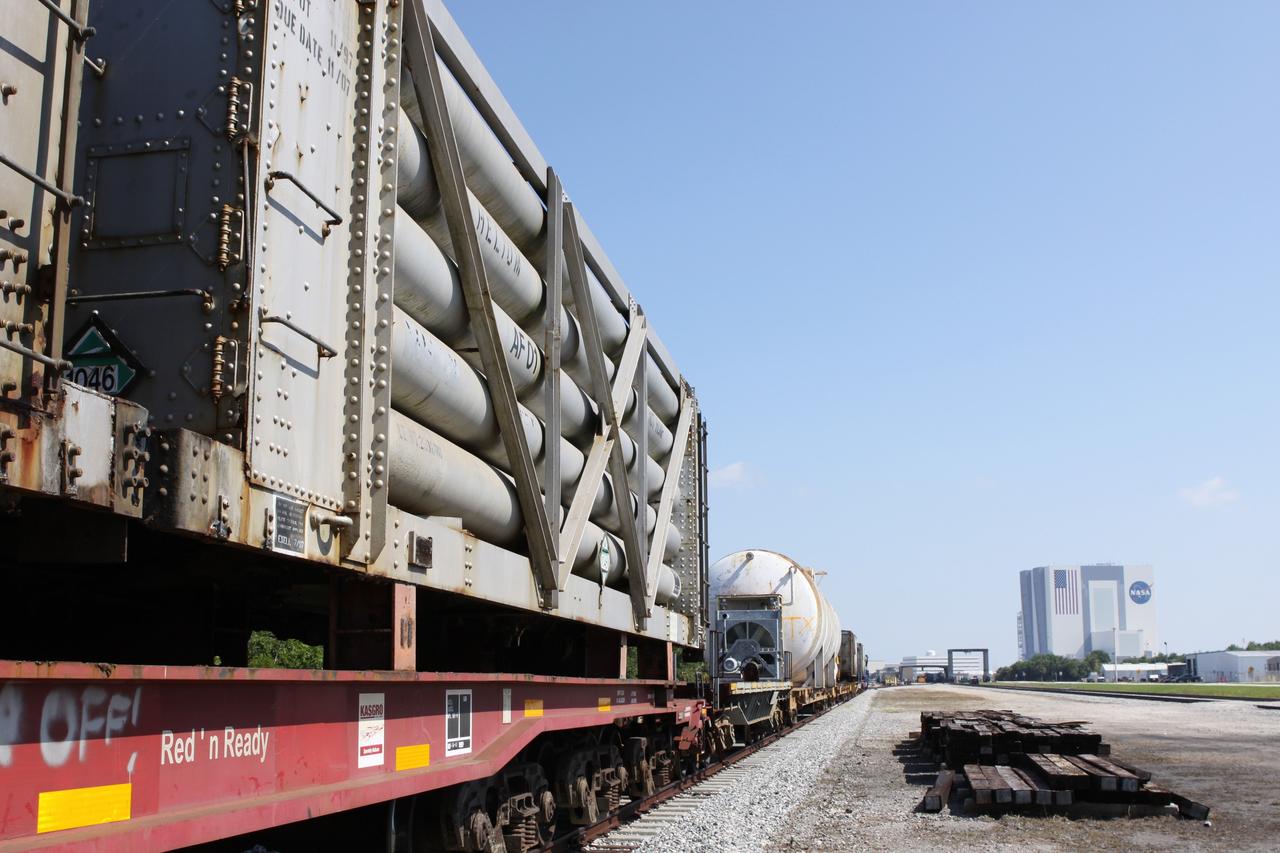
CAPE CANAVERAL, Fla. – At the NASA Railroad Yard at NASA’s Kennedy Space Center in Florida, preparations are under way for the departure of a train made up of tank cars. The railroad’s track runs past Kennedy’s 525-foot-tall Vehicle Assembly Building in the background. The train is headed for the Florida East Coast Railway interchange in Titusville, Fla., where the train’s helium tank cars, a liquid oxygen tank car, and a liquid hydrogen dewar or tank car will be transferred for delivery to the SpaceX engine test complex outside McGregor, Texas. The railroad cars were needed in support of the Space Shuttle Program but currently are not in use by NASA following the completion of the program in 2011. Originally, the tankers belonged to the U.S. Bureau of Mines. At the peak of the shuttle program, there were approximately 30 cars in the fleet. About half the cars were returned to the bureau as launch activity diminished. Five tank cars are being loaned to SpaceX and repurposed to support their engine tests in Texas. Eight cars previously were shipped to California on loan to support the SpaceX Falcon 9 rocket launches from Space Launch Complex-4 on Vandenberg Air Force Base. SpaceX already has three helium tank cars previously used for the shuttle program at Space Launch Complex-40 on Cape Canaveral Air Force Station in Florida. For more information, visit http://www.nasa.gov/spacex. Photo credit: NASA/Jim Grossmann
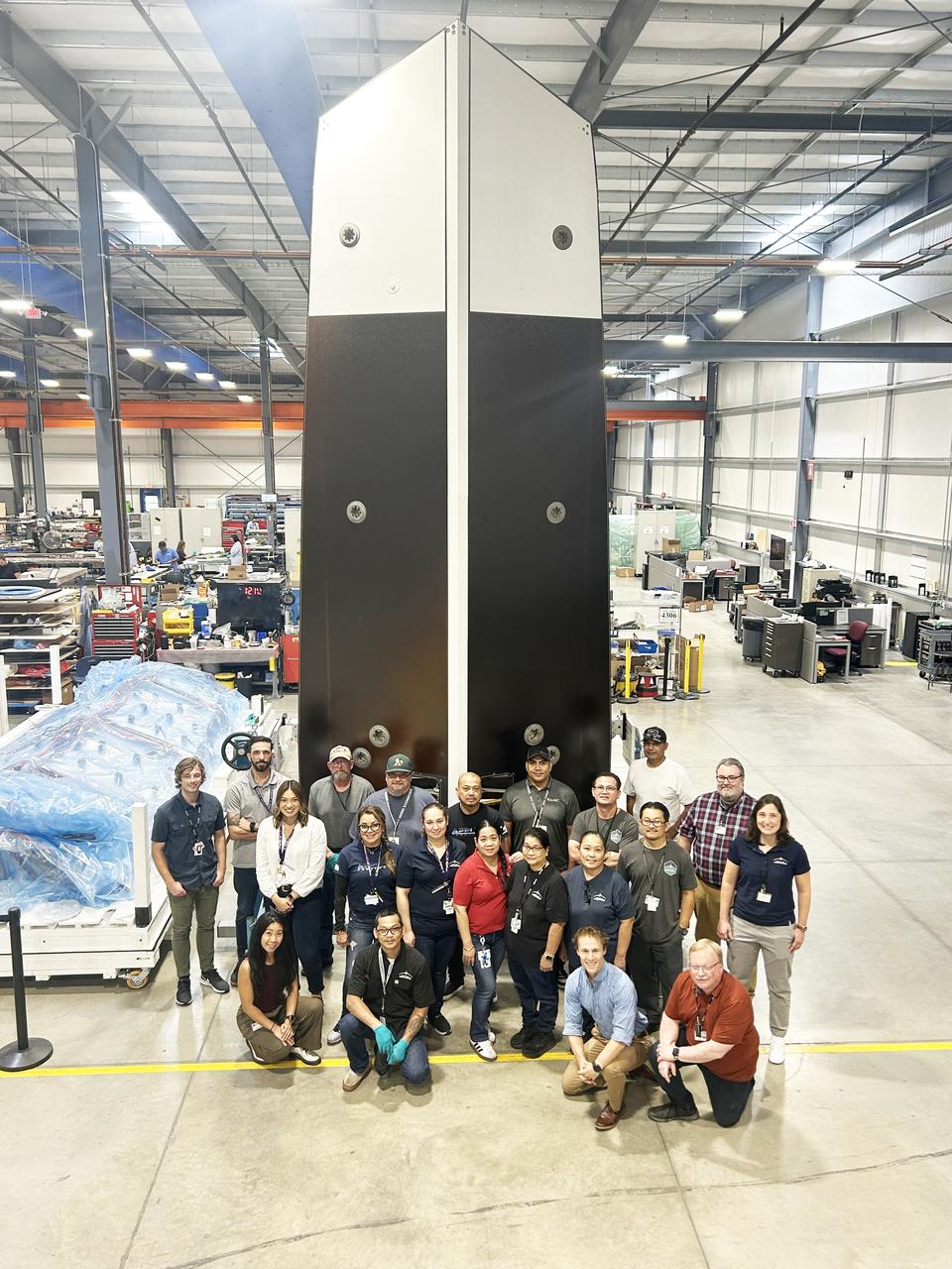
The sunshade for NASA’s Near-Earth Object (NEO) Surveyor mission towers above a fixture at supplier Applied Aerospace in Stockton, California, in September 2025. Standing at over 20 feet (6 meters) high, the sunshade is the largest component of spacecraft. The structure was next shipped to BAE Systems in Boulder, Colorado, for a “fit check” with the spacecraft bus. For scale, technicians and engineers from the project in front of the sunshade. The sunshade’s Sun-facing surface (visible here) will next be fitted with solar panels that will generate power for the spacecraft after launch. The spacecraft’s instrument enclosure, which houses the telescope and sensitive infrared cameras, will be located behind the sunshade, allowing the spacecraft to detect and track near-Earth objects that would otherwise be hidden by the Sun’s glare. Targeting launch in late 2027, the NEO Surveyor mission is led by Professor Amy Mainzer at the University of California, Los Angeles for NASA’s Planetary Defense Coordination Office and is being managed by the agency’s Jet Propulsion Laboratory in Southern California for the Planetary Missions Program Office at NASA’s Marshall Space Flight Center in Huntsville, Alabama. BAE Systems and the Space Dynamics Laboratory in Logan, Utah, and Teledyne are among the companies that were contracted to build the spacecraft and its instrumentation. The Laboratory for Atmospheric and Space Physics at the University of Colorado Boulder will support operations, and IPAC at Caltech in Pasadena, California, is responsible for producing some of the mission’s data products. Caltech manages JPL for NASA. More information about NEO Surveyor is available at: https://science.nasa.gov/mission/neo-surveyor/

A truck arrives at NASA's Jet Propulsion Laboratory in Southern California on June 3, 2024, to deliver the Medium Articulating Transportation System (MATS), which will be used during the construction and transportation of components for NASA's Near-Earth Object Surveyor mission. Originating at the aerospace company Beyond Gravity in Vienna, Austria, the MATS traveled via ship through the Panama Canal to Port Hueneme, California, before arriving by road at JPL. Construction has begun on NEO Surveyor's instrument enclosure in the High Bay 1 clean room at JPL's Spacecraft Assembly Facility. When the enclosure is complete later this year, it will be moved inside the MATS to NASA's Johnson Space Center in Houston for environmental testing. The MATS is a transportable clean room with its own filtration and climate control systems that keep the spacecraft and components clean, stable, and safe while being moved between facilities. NEO Surveyor's instrument enclosure contains the spacecraft's telescope, mirrors, and infrared sensors that will be used to detect, track, and characterize the most hazardous near-Earth objects. BAE Systems, Space Dynamics Laboratory, and Teledyne are among the aerospace and engineering companies contracted to build the spacecraft and its instrumentation. The Laboratory for Atmospheric and Space Physics at the University of Colorado, Boulder will support operations, and IPAC at Caltech in Pasadena, California, is responsible for processing survey data and producing the mission's data products. JPL manages the project; Caltech manages JPL for NASA. Launching no earlier than 2027, NEO Surveyor supports the objectives of NASA's Planetary Defense Coordination Office (PDCO) at NASA Headquarters in Washington. The NASA Authorization Act of 2005 directed NASA to discover and characterize at least 90% of the near-Earth objects more than 140 meters (460 feet) across that come within 30 million miles (48 million kilometers) of our planet's orbit. Objects of this size can cause significant regional damage, or worse, should they impact the Earth. https://photojournal.jpl.nasa.gov/catalog/PIA26381
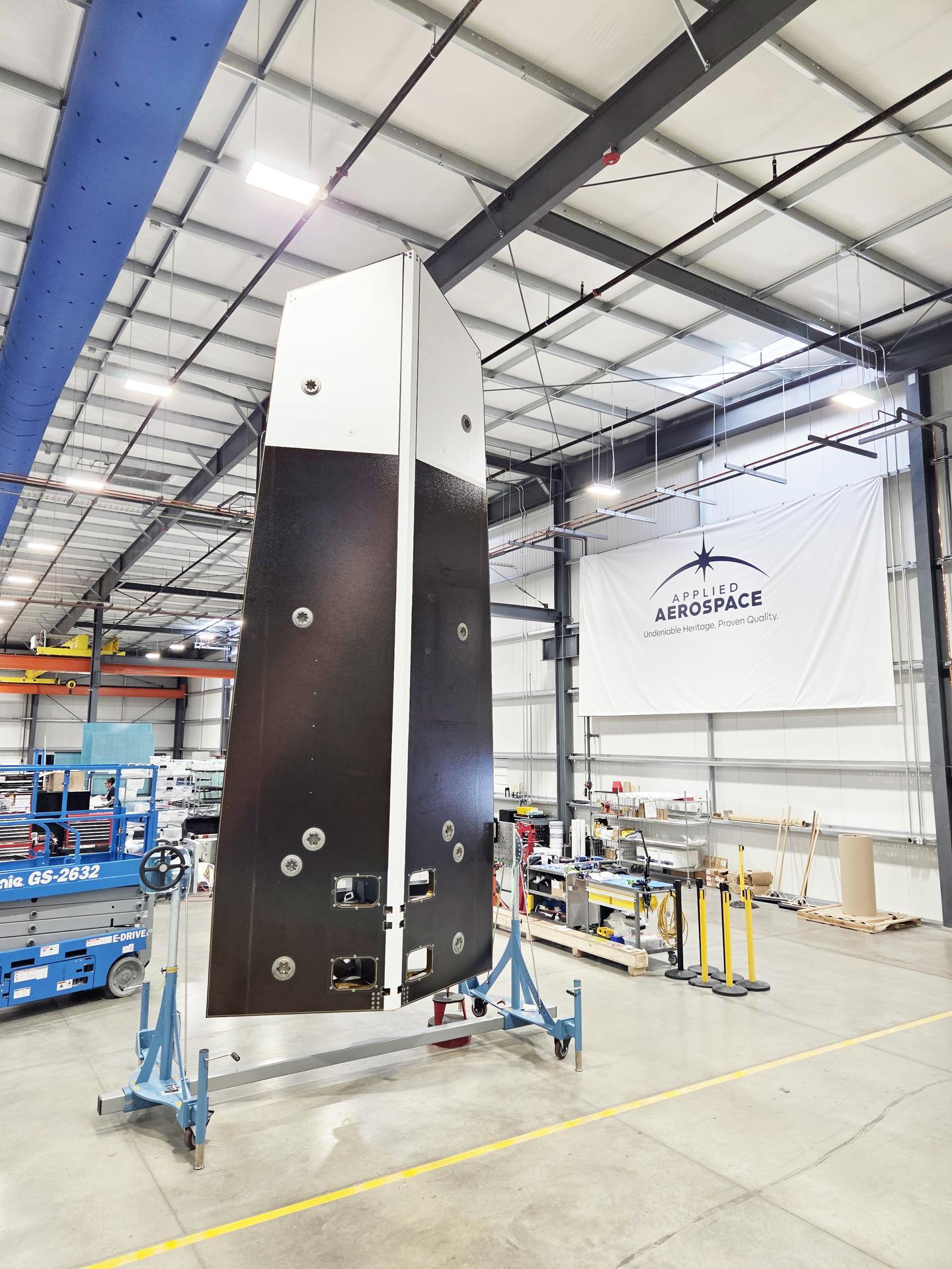
The sunshade for NASA’s Near-Earth Object (NEO) Surveyor mission towers above a fixture at supplier Applied Aerospace in Stockton, California, in September 2025. Standing at over 20 feet (6 meters) high, the sunshade is the largest component of spacecraft. The structure was next shipped to BAE Systems in Boulder, Colorado, for a “fit check” with the spacecraft bus. The sunshade’s Sun-facing surface (visible here) will next be fitted with solar panels that will generate power for the spacecraft after launch. The spacecraft’s instrument enclosure, which houses the telescope and sensitive infrared cameras, will be located behind the sunshade, allowing the spacecraft to detect and track near-Earth objects that would otherwise be hidden by the Sun’s glare. Targeting launch in late 2027, the NEO Surveyor mission is led by Professor Amy Mainzer at the University of California, Los Angeles for NASA’s Planetary Defense Coordination Office and is being managed by the agency’s Jet Propulsion Laboratory in Southern California for the Planetary Missions Program Office at NASA’s Marshall Space Flight Center in Huntsville, Alabama. BAE Systems and the Space Dynamics Laboratory in Logan, Utah, and Teledyne are among the companies that were contracted to build the spacecraft and its instrumentation. The Laboratory for Atmospheric and Space Physics at the University of Colorado Boulder will support operations, and IPAC at Caltech in Pasadena, California, is responsible for producing some of the mission’s data products. Caltech manages JPL for NASA. More information about NEO Surveyor is available at: https://science.nasa.gov/mission/neo-surveyor/
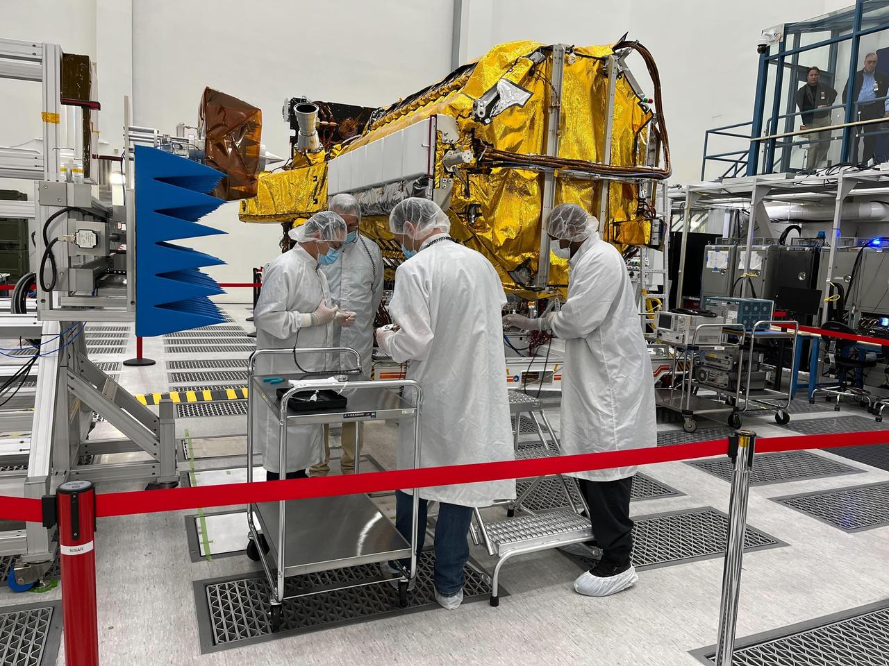
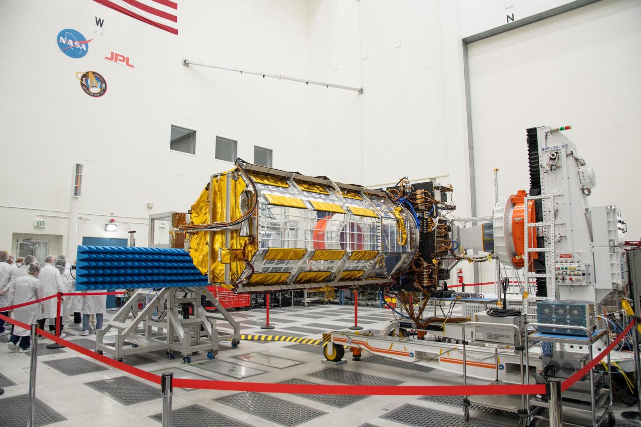
Engineers and technicians from NASA's Jet Propulsion Laboratory work on the NASA-ISRO Synthetic Aperture Radar (NISAR) science instrument payload in a clean room at JPL on Feb. 3, 2023. The payload is scheduled to ship to India in March 2023. The NISAR mission – a joint effort between NASA and ISRO – will measure changes to Earth's land ice surfaces down to fractions of an inch. Data collected by this satellite will help researchers monitor a wide range of changes critical to life on Earth in unprecedented detail. This includes spotting warning signs of imminent volcanic eruptions, helping to monitor groundwater supplies, tracking the melt rate of ice sheets tied to sea level rise, and observing shifts in the distribution of vegetation around the world. The data will inform humanity's responses to urgent challenges posed by natural disasters and climate change, and help communities prepare for and manage hazards. There are two instruments on the satellite that will send and receive radar signals to and from Earth's surface to make the mission's measurements. An L-band synthetic aperture radar (SAR), which uses a signal wavelength of around 9 inches (24 centimeters), and an S-band SAR with a signal wavelength of nearly 5 inches (12 centimeters). Both will bounce their microwave signal off of the planet's surface and record how long it takes the signal to make one roundtrip, as well as the strength of that return signal. This enables the researchers to calculate the distance from the spacecraft to Earth's surface and thereby determine how the land or ice is changing. An antenna reflector nearly 40 feet (12 meters) in diameter, supported by a deployable boom, will focus the microwave signals sent and received by the SARs. JPL, which is managed for NASA by Caltech in Pasadena, leads the U.S. component of NISAR and is providing the mission's L-band SAR instrument. NASA is also providing the radar reflector antenna, the deployable boom, a high-rate communication subsystem for science data, GPS receivers, a solid-state recorder, and payload data subsystem. ISRO is providing the spacecraft bus, the S-band SAR, the launch vehicle, and associated launch services and satellite mission operations. https://photojournal.jpl.nasa.gov/catalog/PIA25771
Image acquired October 30, 2012 Scientists watched the Arctic with particular interest in the summer of 2012, when Arctic sea ice set a new record low. The behavior of sea ice following such a low extent also interests scientists, but as Arctic sea ice was advancing in the autumn of 2012, so was polar darkness. Fortunately, the Visible Infrared Imaging Radiometer Suite (VIIRS) on the Suomi NPP satellite can see in the dark. The VIIRS “day-night band” detects light in a range of wavelengths from green to near-infrared and uses filtering techniques to observe signals such as gas flares, auroras, wildfires, city lights, and reflected moonlight. VIIRS acquired this nighttime view of sea ice north of Russia and Alaska on October 30, 2012. The day-night band takes advantage of moonlight, airglow (the atmosphere’s self-illumination through chemical reactions), zodiacal light (sunlight scattered by interplanetary dust), and starlight from the Milky Way. By using these dim light sources, the day-night band can detect changes in clouds, snow cover, and sea ice. The VIIRS day-night band offers a unique perspective because once polar night has descended, satellite sensors relying on visible light can no longer produce photo-like images. And although passive microwave sensors can monitor sea ice through the winter, they offer much lower resolution. Steve Miller of the Cooperative Institute for Research in the Atmosphere at Colorado State University has used the day-night band to study nighttime behavior of weather systems and sees advantages in studying the polar regions. “There’s a lot of use with these measurements as we look back at a season of record ice melt in the Arctic,” Miller says. “We can observe areas where there is ice melt and reformation, where there’s clear water and ships can pass through—especially as the ‘great darkness’ approaches with winter.” Ted Scambos of the National Snow and Ice Data Center at the University of Colorado concurs. “Things start changing rapidly in the late fall: sea ice formation and snow cover extent at the highest latitudes. This lets us see rapid-growth areas in detail.” The day-night band is also useful for following weather systems, including severe storms, which can develop and strike populous areas at night as well as day. Geostationary Operational Environmental Satellites orbit the Earth’s equator. The satellites offer uninterrupted observations of North America, but high-latitude areas such as Alaska may benefit more from polar-orbiting satellites. Miller explains, “In the high latitudes, the orbits begin to overlap considerably, which gives you a lot more passes in Alaska. If you start to look at multiple passes and stitch them together, you can get a version of a poor man’s geostationary time loop of the weather.” Day-night band imagery at high latitudes has already proven useful for tracking rapid ice movement and diagnosing Gulf of Alaska circulations. The day-night band is even useful at tracking ship movement at high latitudes. NASA Earth Observatory image by Jesse Allen and Robert Simmon, using VIIRS Day-Night Band data from the Suomi National Polar-orbiting Partnership. Suomi NPP is the result of a partnership between NASA, the National Oceanic and Atmospheric Administration, and the Department of Defense. Caption by Michon Scott. Instrument: Suomi NPP - VIIRS Credit: <b><a href="http://www.earthobservatory.nasa.gov/" rel="nofollow"> NASA Earth Observatory</a></b> <b>Click here to view all of the <a href="http://earthobservatory.nasa.gov/Features/NightLights/" rel="nofollow"> Earth at Night 2012 images </a></b> <b>Click here to <a href="http://earthobservatory.nasa.gov/NaturalHazards/view.php?id=79825" rel="nofollow"> read more </a> about this image </b> <b><a href="http://www.nasa.gov/audience/formedia/features/MP_Photo_Guidelines.html" rel="nofollow">NASA image use policy.</a></b> <b><a href="http://www.nasa.gov/centers/goddard/home/index.html" rel="nofollow">NASA Goddard Space Flight Center</a></b> enables NASA
Officials from NASA, the Indian Space Research Organisation, and the Indian Embassy, grouped at left, visit a clean room at NASA's Jet Propulsion Laboratory in Southern California on Feb. 3, 2023, to view the scientific instrument payload for the NASA-ISRO Synthetic Aperture Radar (NISAR) mission. The payload is scheduled to be shipped to India in March 2023. The NISAR mission – a joint effort between NASA and ISRO – will measure changes to Earth's land ice surfaces down to fractions of an inch. Data collected by this satellite will help researchers monitor a wide range of changes critical to life on Earth in unprecedented detail. This includes spotting warning signs of imminent volcanic eruptions, helping to monitor groundwater supplies, tracking the melt rate of ice sheets tied to sea level rise, and observing shifts in the distribution of vegetation around the world. The data will inform humanity's responses to urgent challenges posed by natural disasters and climate change, and help communities prepare for and manage hazards. There are two instruments on the satellite that will send and receive radar signals to and from Earth's surface to make the mission's measurements. An L-band synthetic aperture radar (SAR), which uses a signal wavelength of around 9 inches (24 centimeters), and an S-band SAR with a signal wavelength of nearly 5 inches (12 centimeters). Both will bounce their microwave signal off of the planet's surface and record how long it takes the signal to make one roundtrip, as well as the strength of that return signal. This enables the researchers to calculate the distance from the spacecraft to Earth's surface and thereby determine how the land or ice is changing. An antenna reflector nearly 40 feet (12 meters) in diameter, supported by a deployable boom, will focus the microwave signals sent and received by the SARs. JPL, which is managed for NASA by Caltech in Pasadena, leads the U.S. component of NISAR and is providing the mission's L-band SAR instrument. NASA is also providing the radar reflector antenna, the deployable boom, a high-rate communication subsystem for science data, GPS receivers, a solid-state recorder, and payload data subsystem. ISRO is providing the spacecraft bus, the S-band SAR, the launch vehicle, and associated launch services and satellite mission operations. https://photojournal.jpl.nasa.gov/catalog/PIA25599
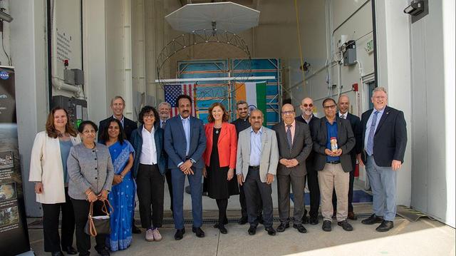
Officials from NASA, the Indian Space Research Organization (ISRO), and the Embassy of India hold a send-off ceremony for the NASA-ISRO Synthetic Aperture Radar (NISAR) science instrument payload on Feb. 3, 2023, outside a clean room at NASA's Jet Propulsion Laboratory in Southern California. The payload is scheduled to be shipped to India in March. Pictured left to right: Karen St. Germain, director, Earth Science Division, NASA; Mitra Dutta, NISAR program executive, NASA; Sripriya Ranganathan, ambassador and deputy chief of mission, Indian Embassy; Larry James, deputy director, JPL; Bhavya Lal, associate administrator for technology, policy, and strategy, NASA; Jim Graf, director, Earth Science and Technology Directorate, JPL; S. Somanath, chairman, ISRO; Laurie Leshin, director, JPL; Krunal Joshi, counselor, space and ISRO technical liaison officer, Indian Embassy; M. Sankaran, director, U R Rao Satellite Centre, ISRO; Shantanu Bhatawdekar, scientific secretary, ISRO; Paul Rosen, NISAR project scientist, JPL; CV Shrikant, NISAR project director, ISRO; Phil Barela, NISAR project manager, JPL; and Gerald Bawden, NISAR program scientist, NASA. NISAR – a joint effort between NASA and ISRO – will measure changes to Earth's land ice surfaces down to fractions of an inch. Data collected by this satellite will help researchers monitor a wide range of changes critical to life on Earth in unprecedented detail. This includes spotting warning signs of imminent volcanic eruptions, helping to monitor groundwater supplies, tracking the melt rate of ice sheets tied to sea level rise, and observing shifts in the distribution of vegetation around the world. The data will inform humanity's responses to urgent challenges posed by natural disasters and climate change, and help communities prepare for and manage hazards. There are two instruments on the satellite that will send and receive radar signals to and from Earth's surface to make the mission's measurements. An L-band synthetic aperture radar (SAR), which uses a signal wavelength of around 9 inches (24 centimeters), and an S-band SAR with a signal wavelength of nearly 5 inches (12 centimeters). Both will bounce their microwave signal off of the planet's surface and record how long it takes the signal to make one roundtrip, as well as the strength of that return signal. This enables the researchers to calculate the distance from the spacecraft to Earth's surface and thereby determine how the land or ice is changing. An antenna reflector nearly 40 feet (12 meters) in diameter, supported by a deployable boom, will focus the microwave signals sent and received by the SARs. JPL, which is managed for NASA by Caltech in Pasadena, leads the U.S. component of NISAR and is providing the mission's L-band SAR instrument. NASA is also providing the radar reflector antenna, the deployable boom, a high-rate communication subsystem for science data, GPS receivers, a solid-state recorder, and payload data subsystem. ISRO is providing the spacecraft bus, the S-band SAR, the launch vehicle, and associated launch services and satellite mission operations. https://photojournal.jpl.nasa.gov/catalog/PIA25600

Situated between the Black Sea and the Aegean Sea, the Sea of Marmara is full of a rich soup of nutrients and life and surrounded by a rich history of civilization. Like the Black Sea to its northeast, the Marmara has an unusual layered structure with fresher water near the surface and much saltier water near the bottom. That fresh surface is fed by exchanges with the Black Sea and by flows from the Susurluk, Biga, and Gonen Rivers. The fresh water (just two thirds the salinity of the ocean) makes it easier for floating, plant-like organisms—phytoplankton—to grow, as does the abundance of nutrients pouring into the seas from European and Turkish rivers. The Operational Land Imager on the Landsat 8 satellite captured this image of a phytoplankton bloom in the Sea of Marmara on May 17, 2015. The sea is surrounded on all sides by the nation of Turkey. The swirling shapes on the water are phytoplankton, with the yellow-green and red-purple filaments likely (but not necessarily) representing different species. Those wavy colored lines not only show where the densest concentrations of plankton are floating, but also reveal the eddies and currents within the small sea. Waters rushing in through the narrow Bosphorous Strait (at Istanbul) and Dardanelles Strait (off the left side of the image), as well as a jagged coastline and tectonically fractured seafloor on this edge of the Asian and European continents, all conspire to create intricate mixing patterns. If you download the large image and open it in full resolution, you also can see ship tracks crossing the bloom lines. “I often see features in imagery and wonder: what could be causing that?” said Norman Kuring, an ocean color specialist at NASA Goddard. “Remote sensing is great for the big picture, but it still needs data from the surface for validation and interpretation.” According to scientists Baris Salihoglu of Turkey’s Institute of Marine Sciences and Ahsen Yuksek of Istanbul University, the blooms in the satellite image are mostly Prorocentrum micans and Noctiluca scintillans. They recently sampled the waters of the Marmara and found that Prorocentrum bloomed first, though Noctiluca eventually dominated. According to Ajit Subramaniam of the Lamont Doherty Earth Observatory, both species are dinoflagellates, known to discolor the water (red tides). Neither is directly toxic to humans, but they can kill marine life by becoming caught in fish gills, depleting the sea of oxygen, or excreting ammonia into the water. “Noctiluca is phagotrophic—a really interesting beast since it eats other phytoplankton that can then change its color,” Subramaniam noted. “It switches from being photosynthetic to becoming heterotrophic.” The Moderate Resolution Imaging Spectroradiometer (MODIS) on NASA’s Terra satellite captured wider views of bloom events in the Sea of Marmara on on May 23 and May 25. Credit: <b><a href="http://www.earthobservatory.nasa.gov/" rel="nofollow"> NASA Earth Observatory</a></b> Read more: <a href="http://earthobservatory.nasa.gov/IOTD/view.php?id=85947" rel="nofollow">earthobservatory.nasa.gov/IOTD/view.php?id=85947</a> <b><a href="http://www.nasa.gov/audience/formedia/features/MP_Photo_Guidelines.html" rel="nofollow">NASA image use policy.</a></b> <b><a href="http://www.nasa.gov/centers/goddard/home/index.html" rel="nofollow">NASA Goddard Space Flight Center</a></b> enables NASA’s mission through four scientific endeavors: Earth Science, Heliophysics, Solar System Exploration, and Astrophysics. Goddard plays a leading role in NASA’s accomplishments by contributing compelling scientific knowledge to advance the Agency’s mission. <b>Follow us on <a href="http://twitter.com/NASAGoddardPix" rel="nofollow">Twitter</a></b> <b>Like us on <a href="http://www.facebook.com/pages/Greenbelt-MD/NASA-Goddard/395013845897?ref=tsd" rel="nofollow">Facebook</a></b> <b>Find us on <a href="http://instagrid.me/nasagoddard/?vm=grid" rel="nofollow">Instagram</a></b>