This 1989 artist's rendering shows how a Shuttle-C would look during launch. As envisioned by Marshall Space Flight Center plarners, the Shuttle-C would be an unmanned heavy-lift cargo vehicle derived from Space Shuttle elements. The vehicle would utilize the basic Shuttle propulsion units (Solid Rocket Boosters, Space Shuttle Main Engine, External Tank), but would replace the Orbiter with an unmanned Shuttle-C Cargo Element (SCE). The SCE would have a payload bay lenght of eighty-two feet, compared to sixty feet for the Orbiter cargo bay, and would be able to deliver 170,000 pound payloads to low Earth orbit, more than three times the Orbiter's capacity.
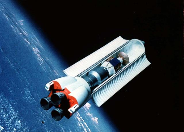
In this 1989 artist's concept, the Shuttle-C floats in space with its cargo bay doors open. As envisioned by Marshall Space Flight Center plarners, the Shuttle-C would be an unmanned heavy lift cargo vehicle derived from Space Shuttle elements. The vehicle would utilize the basic Shuttle propulsion units (Solid Rocket Boosters, Space Shuttle Main Engine, External Tank), but would replace the Oribiter with an unmanned Shuttle-C Cargo Element (SCE). The SCE would have a payload bay length of eighty-two feet, compared to sixty feet for the Orbiter cargo bay, and would be able to deliver 170,000 pound payloads to low Earth orbit, more than three times the Orbiter's capacity.
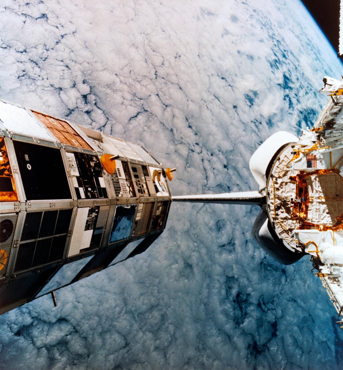
Photo from Space Shuttle Mission 41-C of the Long Duration Exposure Facility (LDEF) deploy by CHALLENGER and a Langley Research Center (LRC) supplied art concept of the LDEF recovery by COLUMBIA during Space Shuttle Mission STS-32. LRC # L-89-11-720 for JSC # S89-50779
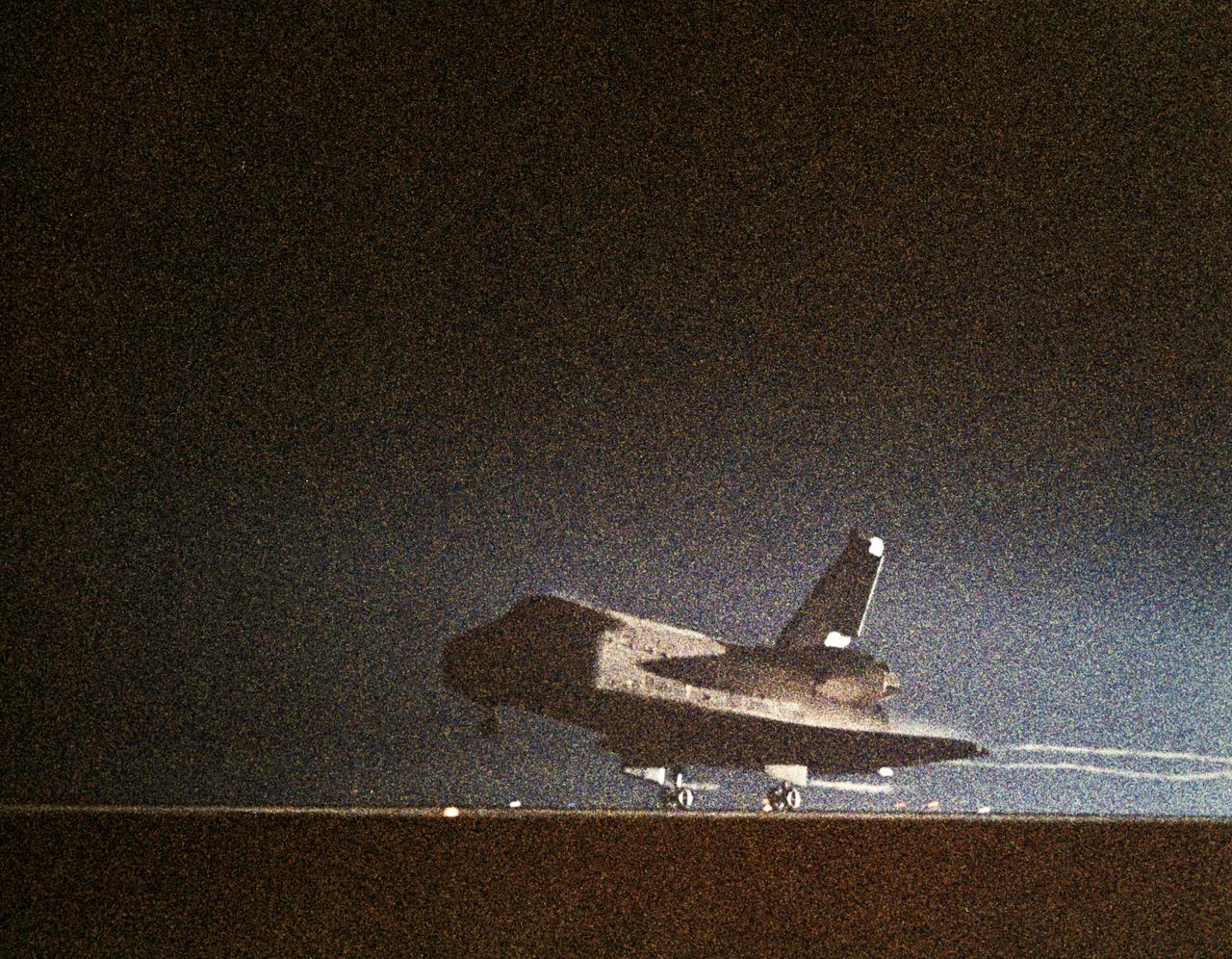
61C-S-050 (18 Jan 1986) --- This NASA photo records the night landing of space shuttle Columbia at Edwards Air Force Base and end of the STS 61-C mission. View is of the shuttle's main landing gear touching down, with streams of light trailing behind the orbiter. Photo credit: NASA
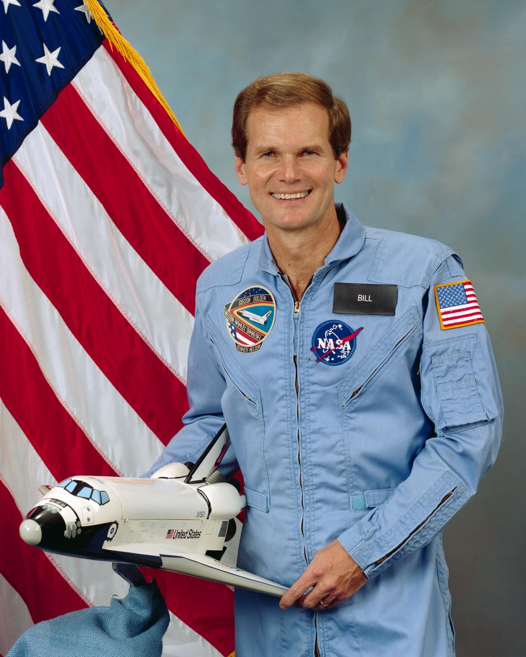
S85-43440 (25 Oct. 1985) --- Official portrait of Congressman Bill Nelson, U.S. House of Representatives - Florida, STS 61-C payload specialist. He is in the blue shuttle flight suit, holding a model of the shuttle with an American flag behind him.
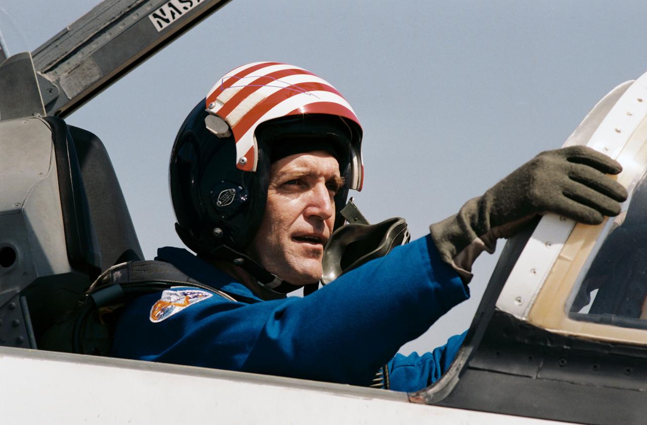
41C-3002 (3 April 1984) --- Astronaut Francis R. (Dick) Scobee, 41-C pilot, is only minutes away from leaving Ellington Air Base in a T-38. Scobee and four other 41-C crewmembers, along with Astronaut John W. Young, are headed for Florida, site of a launch in three days of the Space Shuttle Challenger. Scobee, an experienced pilot, is responsible for helping a number of other NASA astronauts learn to fly. The eleventh Space Shuttle mission will mark his first experience in space. This photograph was taken by Otis Imboden.

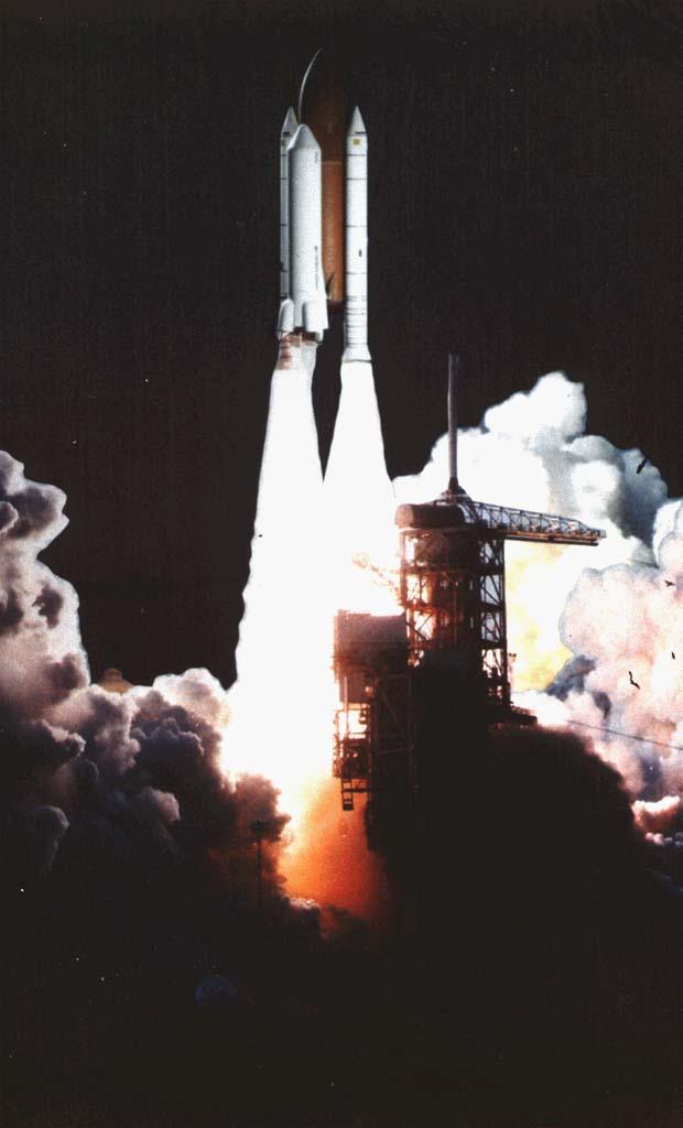
41C-3029 (6 April 1984) --- The space shuttle Challenger and its five-member astronaut crew leave the launch pad at the Kennedy Space Center to begin a six-day stay in space. Astronaut John W. Young, a veteran of two shuttle missions and six spaceflights overall, recorded the image with a handheld 70mm camera from the shuttle training aircraft which he was using to monitor environmental conditions around Florida. This is the eighth mission on which Young photographed one of NASA's orbiter vehicles beginning its orbital stay. Photo credit: NASA
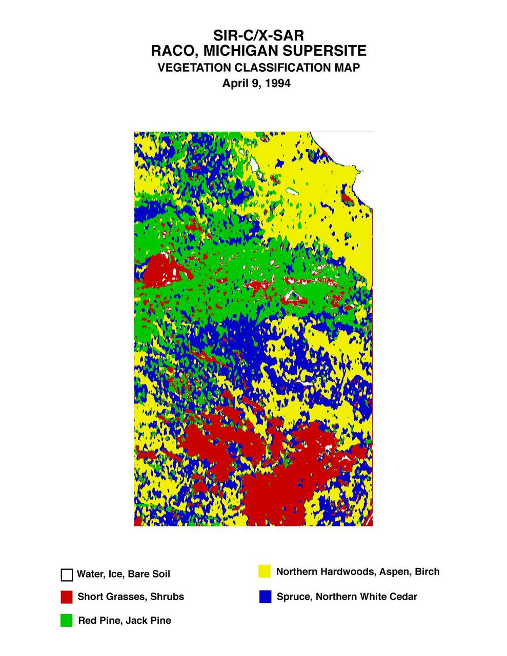
This is a vegetation map of the Raco, Michigan area produced from data acquired by NASA Spaceborne Imaging Radar C/X-Band Synthetic Aperture Radar SIR-C/X-SAR onboard space shuttle Endeavour.
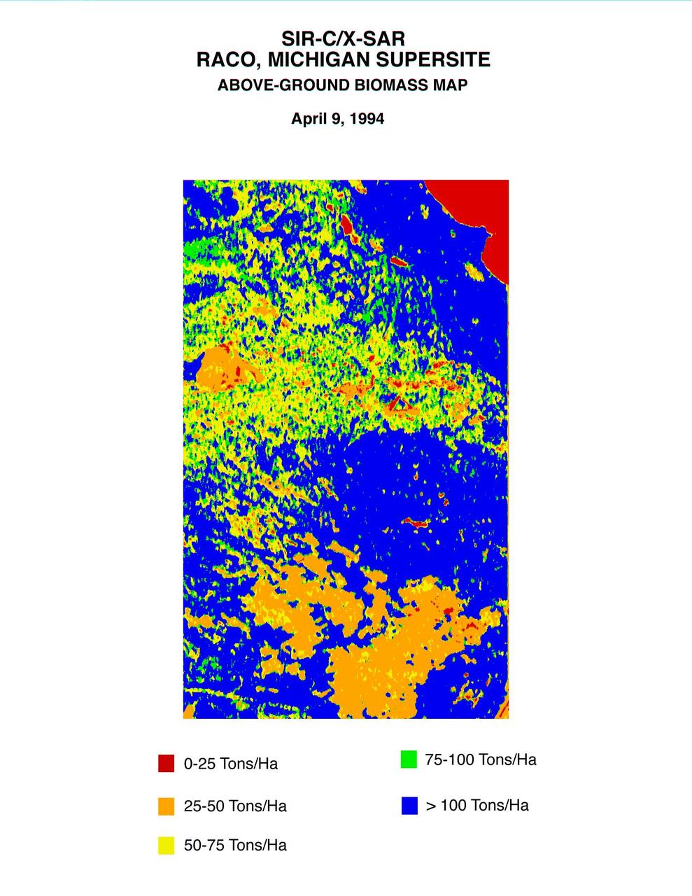
This biomass map of the Raco, Michigan, area was produced from data acquired by NASA Spaceborne Imaging Radar C/X-Band Synthetic Aperture Radar SIR-C/X-SAR onboard space shuttle Endeavour.
This color composite C-band and L-band image of the Kilauea volcano on the Big Island of Hawaii was acquired by NASA Spaceborne Imaging Radar-C/X-band Synthetic Aperture Radar SIR-C/X-SAR flying on space shuttle Endeavour.
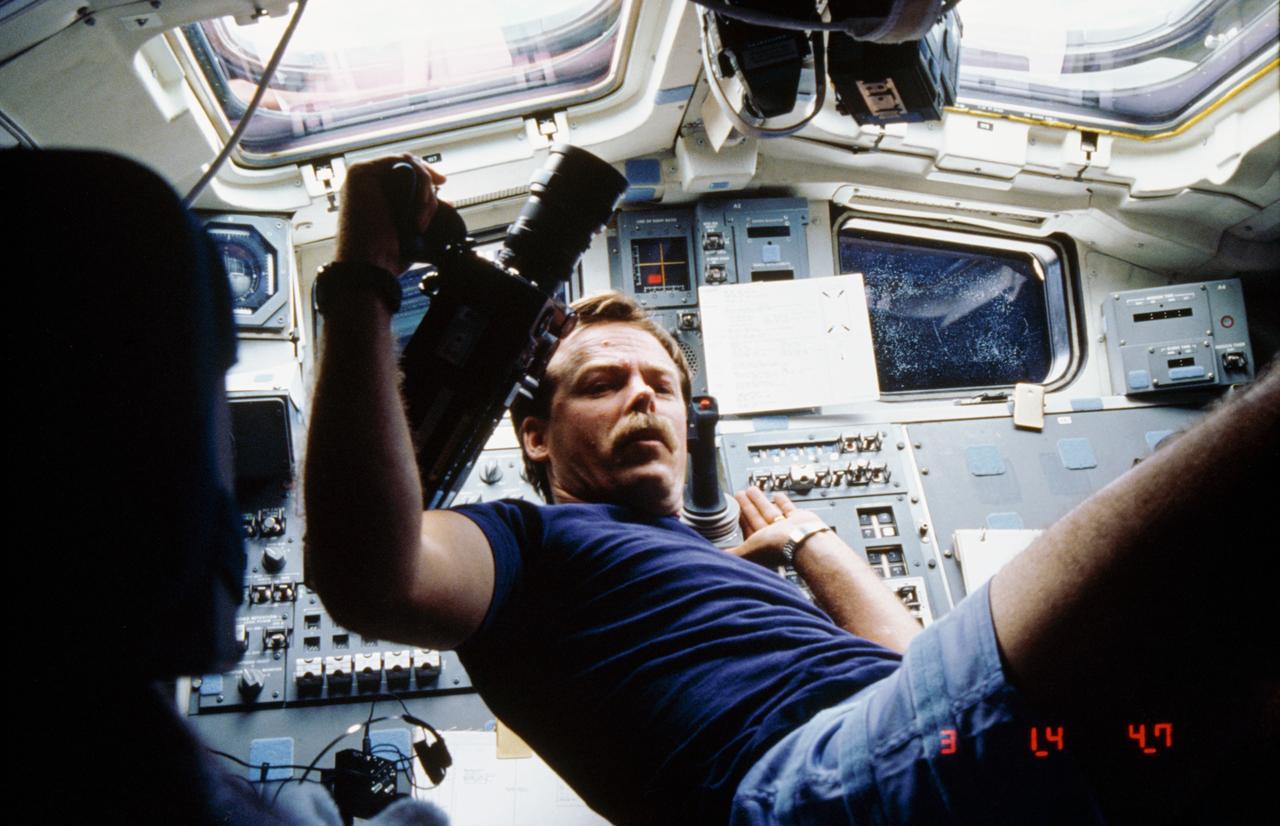
61C-07-030 (15 Jan 1986) --- Astronaut Robert L. Gibson, STS 61-C mission commander, partially floats on the aft flight deck of the earth-orbiting Space Shuttle Columbia while preparing to use a motion picture camera. The windows overlooking the cargo bay are visible in the background.
STS61C-S-046 (12 Jan. 1986) --- Although many miles away from the launch pad, the space shuttle Columbia can still be seen in this distant scene. The scene was recorded around 7 a.m. (EST), Jan. 12, 1986. Photo credit: NASA
STS61C-S-047 (12 Jan. 1986) --- A remote camera records the early morning launch at Florida?s Kennedy Space Center of the space shuttle Columbia and the STS-61C crew on Jan. 12, 1986. Onboard were the following crew members -- Mission Commander Robert L. Gibson and Pilot Charles F. Bolden, along with Mission Specialists Franklin R. Chang-Diaz, Steven A. Hawley and George D. Nelson and Payload Specialists Robert J. Cenker of RCA and U.S. Rep. Bill Nelson. Photo credit: NASA
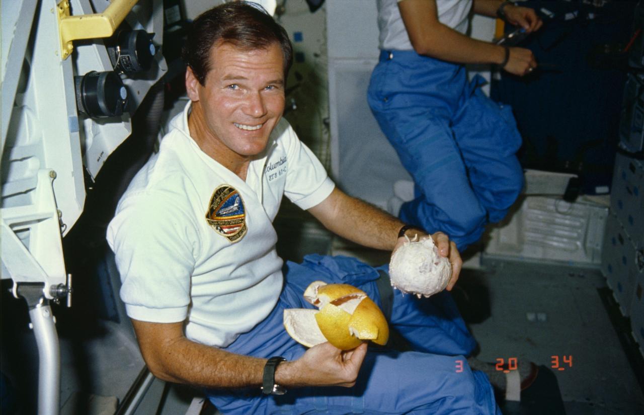
61C-09-005 (15 Jan 1986) --- U.S. Representative Bill Nelson, (D. Florida), STS 61-C payload specialist, prepares to enjoy a freshly peeled grapefruit on the middeck of the earth-orbiting Space Shuttle Columbia.
In addition to an elevation model of most of Earth landmass, NASA Shuttle Radar Topography Mission will produce C-band radar imagery of the same area.
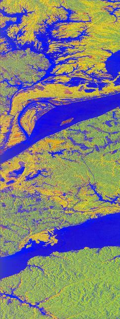
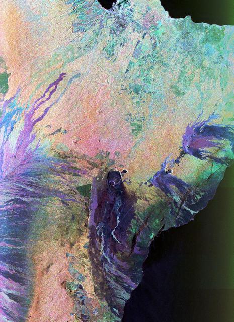
This false-color L-band image of the Manaus region of Brazil was acquired by NASA Spaceborne Imaging Radar-C and X-Band Synthetic Aperture Radar SIR-C/X-SAR aboard the space shuttle Endeavour on orbit 46 of the mission.
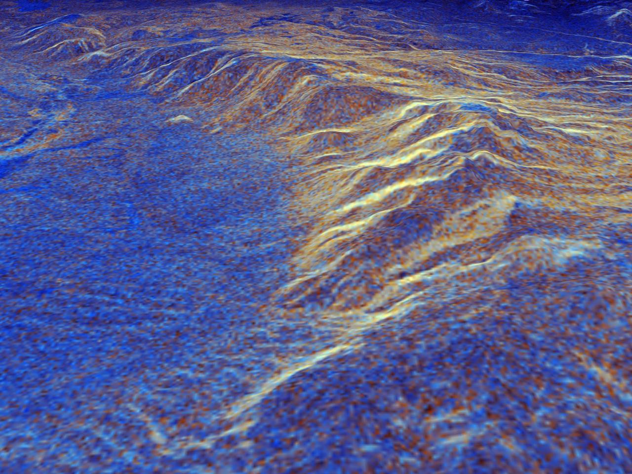
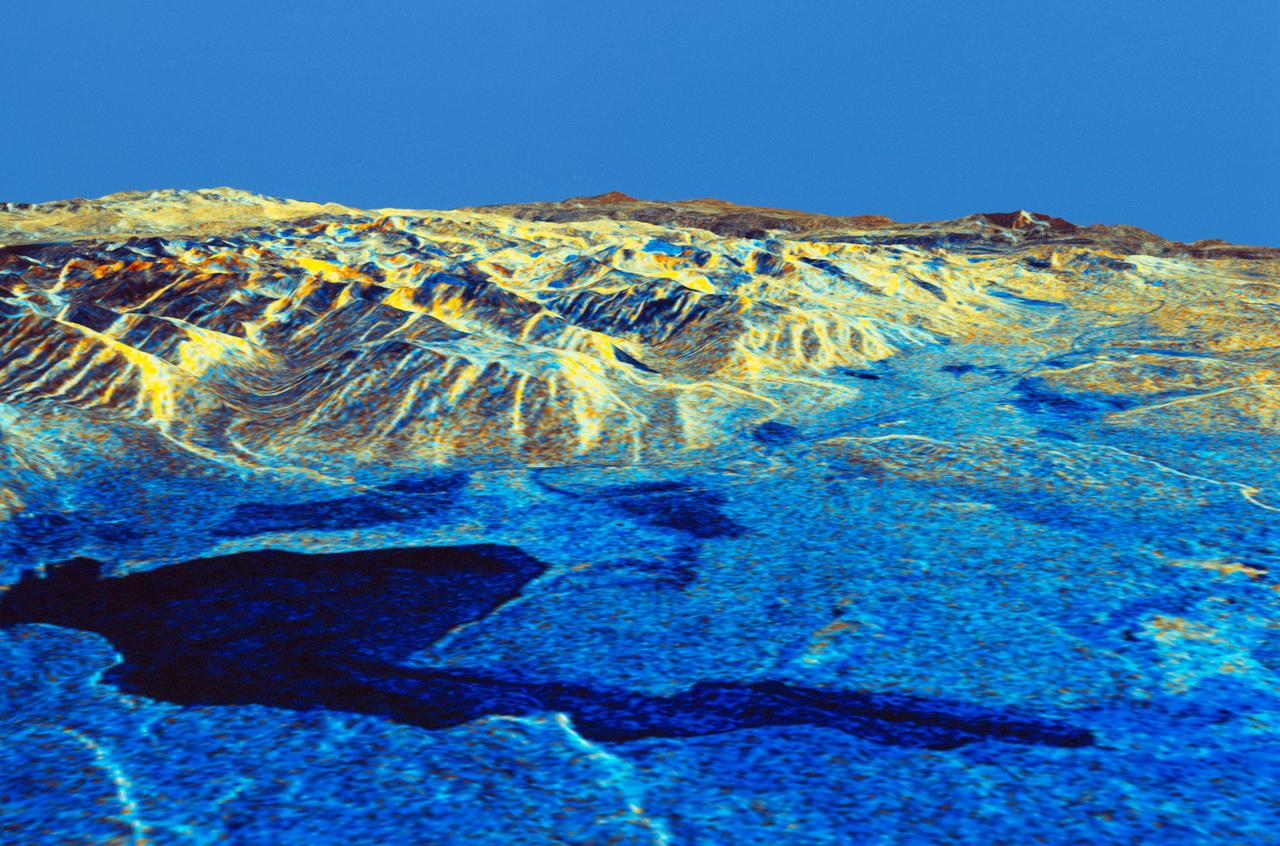
This is a three-dimensional perspective view of Long Valley, California by the Spaceborne Imaging Radar-C/X-band Synthetic Aperture Radar on board the space shuttle Endeavour. This view was constructed by overlaying a color composite SIR-C image on a digital elevation map. The digital elevation map was produced using radar interferometry, a process by which radar data are acquired on different passes of the space shuttle and, which then, are compared to obtain elevation information. The data were acquired on April 13, 1994 and on October 3, 1994, during the first and second flights of the SIR-C/X-SAR radar instrument. The color composite radar image was produced by assigning red to the C-band (horizontally transmitted and vertically received) polarization; green to the C-band (vertically transmitted and received) polarization; and blue to the ratio of the two data sets. Blue areas in the image are smooth and yellow areas are rock outcrops with varying amounts of snow and vegetation. The view is looking north along the northeastern edge of the Long Valley caldera, a volcanic collapse feature created 750,000 years ago and the site of continued subsurface activity. Crowley Lake is off the image to the left. http://photojournal.jpl.nasa.gov/catalog/PIA01757
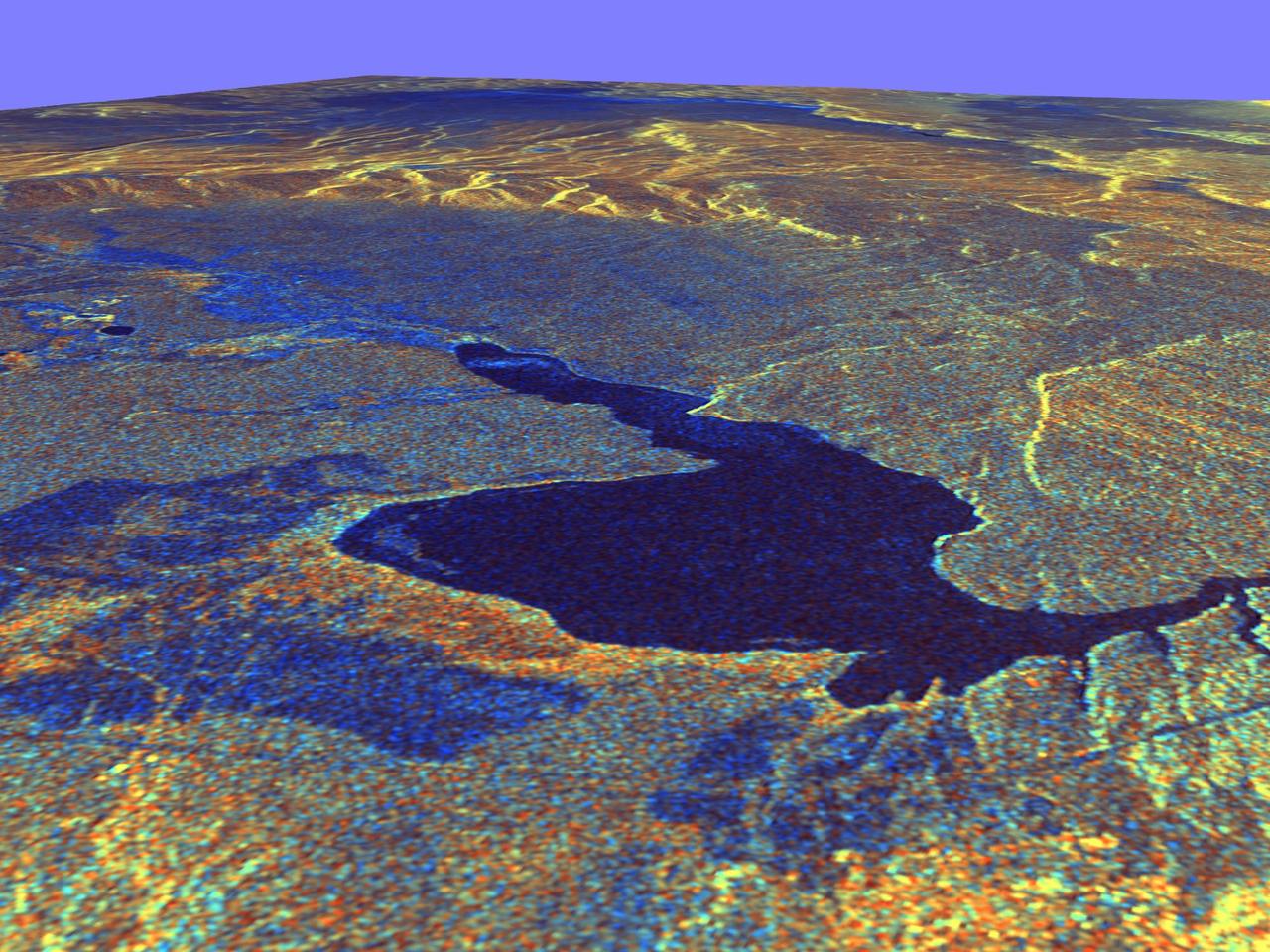
This three-dimensional perspective view of Long Valley, California was created from data taken by the Spaceborne Imaging Radar-C/X-band Synthetic Aperture Radar on board the space shuttle Endeavour. This image was constructed by overlaying a color composite SIR-C radar image on a digital elevation map. The digital elevation map was produced using radar interferometry, a process by which radar data are acquired on different passes of the space shuttle. The two data passes are compared to obtain elevation information. The interferometry data were acquired on April 13,1994 and on October 3, 1994, during the first and second flights of the SIR-C/X-SAR instrument. The color composite radar image was taken in October and was produced by assigning red to the C-band (horizontally transmitted and vertically received) polarization; green to the C-band (vertically transmitted and received) polarization; and blue to the ratio of the two data sets. Blue areas in the image are smooth and yellow areas are rock outcrops with varying amounts of snow and vegetation. The view is looking north along the northeastern edge of the Long Valley caldera, a volcanic collapse feature created 750,000 years ago and the site of continued subsurface activity. Crowley Lake is the large dark feature in the foreground. http://photojournal.jpl.nasa.gov/catalog/PIA01769
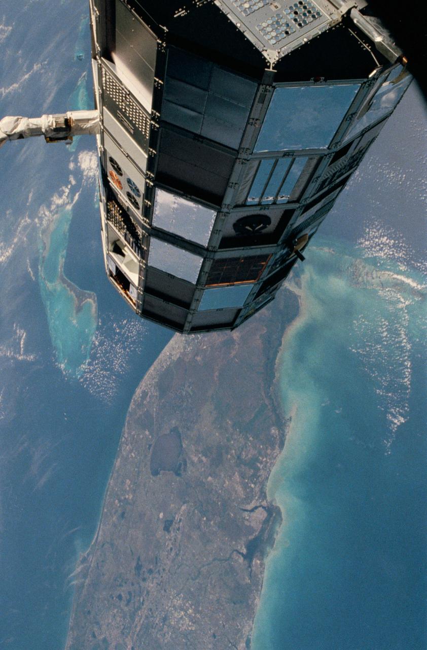
NASA SIR-C/X-SAR is shown here in the payload bay of the orbiting space shuttle Endeavour STS-59, with an area of the Pacific Ocean northeast of Hawaii in the background.
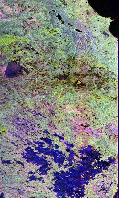
This image is a false-color composite of Raco, Michigan, centered at 46.39 degrees north latitude, 84.88 degrees west longitude. This image was acquired by the Spaceborne Imaging Radar-C and X-Band Synthetic Aperture Radar (SIR-C/X-SAR) aboard the space shuttle Endeavour on its sixth orbit and during the first full-capability test of the instrument on April 9, 1994. This image was produced using both L-band and C-band data. The area shown is approximately 20 kilometers by 50 kilometers (12 by 30 miles). Raco is located at the eastern end of Michigan's upper peninsula, west of Sault Ste. Marie and south of Whitefish Bay on Lake Superior. The site is located at the boundary between the boreal forests and the northern temperate forests, a transitional zone that is expected to be ecologically sensitive to anticipated global changes resulting from climatic warming. On any given day, there is a 60 percent chance that this area will be obscured to some extent by cloud clover which makes it difficult to image using optical sensors. http://photojournal.jpl.nasa.gov/catalog/PIA01700
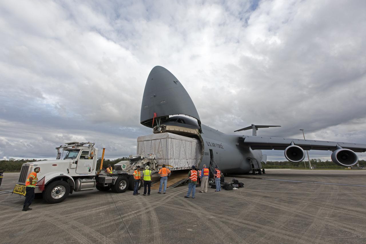
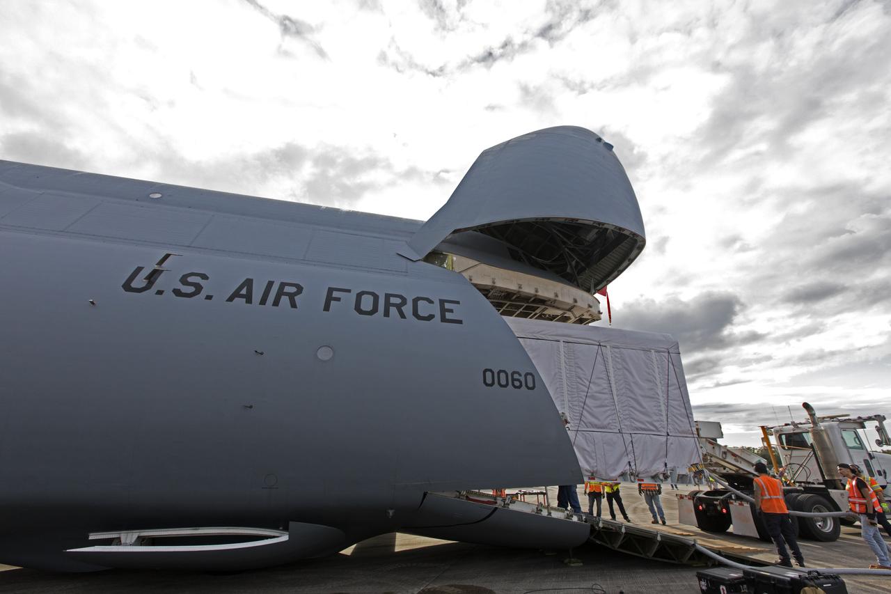
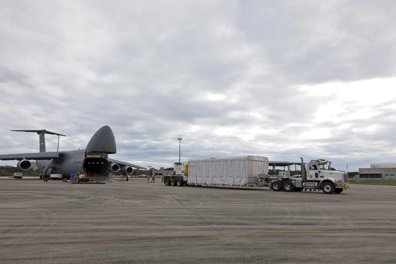
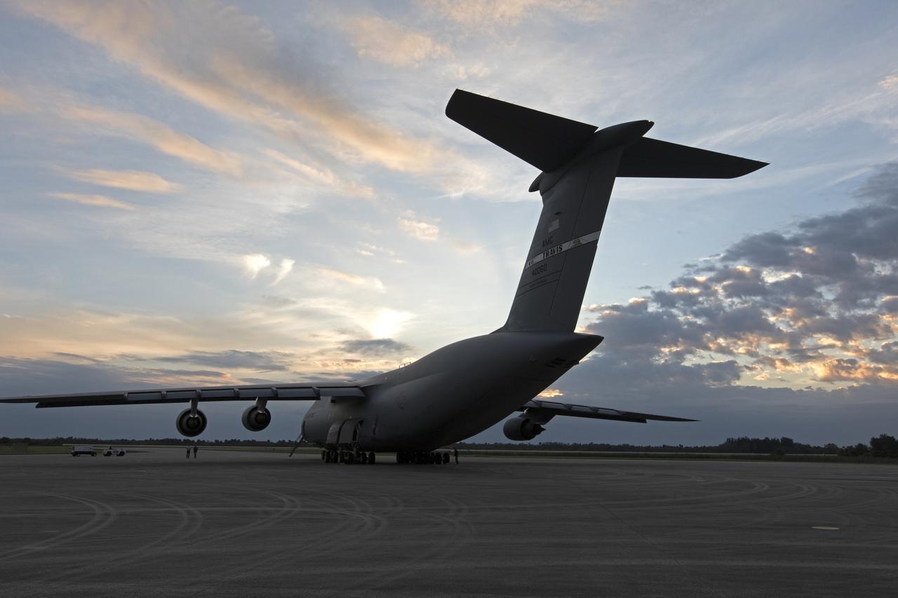
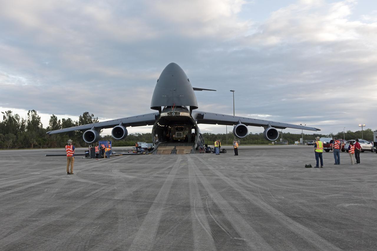
NOAA's Geostationary Operation Environmental Satellite-S (GOES-S) has been offloaded from a C-5 transport aircraft and secured onto the flatbed of a heavy-lift truck at the Shuttle Landing Facility at NASA's Kennedy Space Center in Florida. The satellite will be transported to the Astrotech Space Operations facility in Titusville, Florida to prepare it for launch. GOES-S is the second in a series of four advanced geostationary weather satellites. The GOES-R series - consisting of the GOES-R, GOES-S, GOES-T and GOES-U spacecraft - will significantly improve the detection and observation of environmental phenomena that directly affect public safety, protection of property and the nation's economic health and prosperity. GOES-S is slated to launch March 1, 2018 aboard a United Launch Alliance Atlas V rocket from Cape Canaveral Air Force Station in Florida.
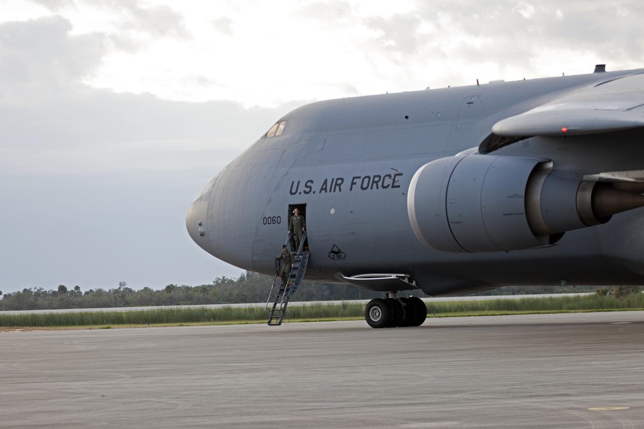
A C-5 transport aircraft arrives at the Shuttle Landing Facility at NASA's Kennedy Space Center in Florida, carrying the Geostationary Operation Environmental Satellite-S (GOES-S). The satellite will be offloaded and transported to the Astrotech Space Operations facility in Titusville, Florida. GOES-S is the second in a series of four advanced geostationary weather satellites. The GOES-R series - consisting of the GOES-R, GOES-S, GOES-T and GOES-U spacecraft - will significantly improve the detection and observation of environmental phenomena that directly affect public safety, protection of property and the nation's economic health and prosperity. GOES-S is slated to launch March 1, 2018 aboard a United Launch Alliance Atlas V rocket from Cape Canaveral Air Force Station in Florida.
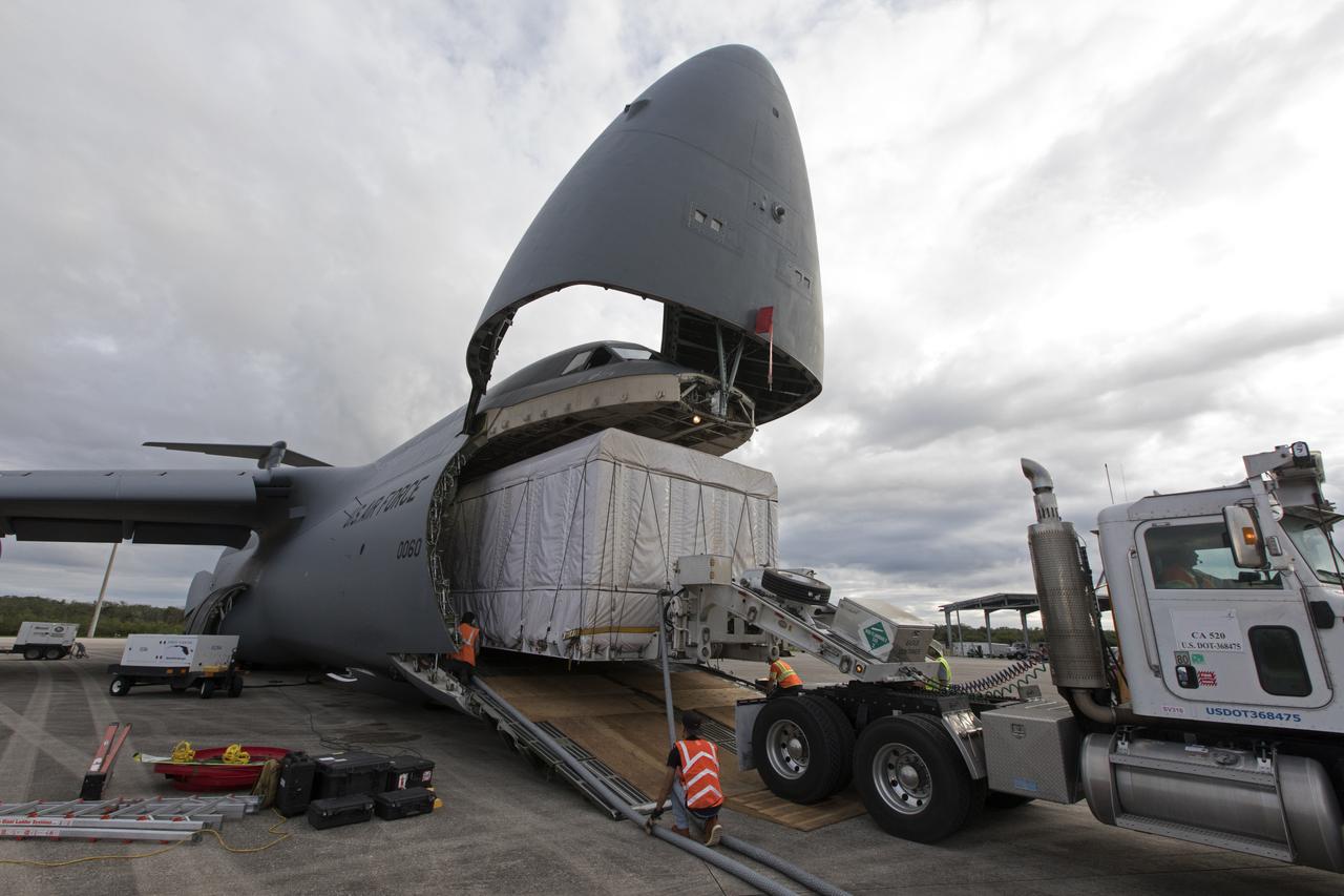
NOAA's Geostationary Operation Environmental Satellite-S (GOES-S) is being offloaded from a C-5 transport aircraft at the Shuttle Landing Facility at NASA's Kennedy Space Center in Florida. The satellite will be transported to the Astrotech Space Operations facility in Titusville, Florida to prepare it for launch. GOES-S is the second in a series of four advanced geostationary weather satellites. The GOES-R series - consisting of the GOES-R, GOES-S, GOES-T and GOES-U spacecraft - will significantly improve the detection and observation of environmental phenomena that directly affect public safety, protection of property and the nation's economic health and prosperity. GOES-S is slated to launch March 1, 2018 aboard a United Launch Alliance Atlas V rocket from Cape Canaveral Air Force Station in Florida.
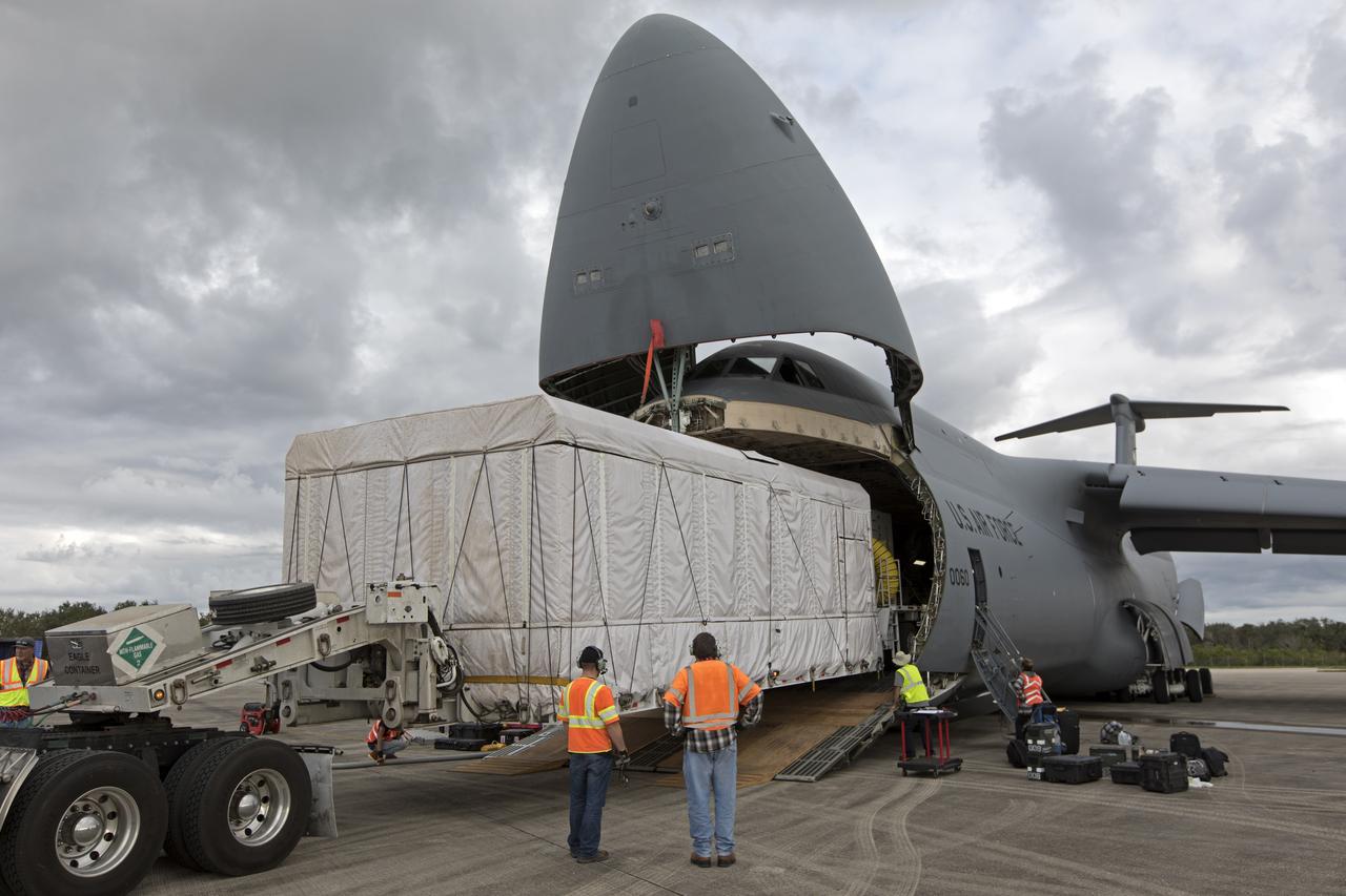
NOAA's Geostationary Operation Environmental Satellite-S (GOES-S) is being offloaded from a C-5 transport aircraft onto the flatbed of a heavy-lift truck at the Shuttle Landing Facility at NASA's Kennedy Space Center in Florida. The satellite will be transported to the Astrotech Space Operations facility in Titusville, Florida to prepare it for launch. GOES-S is the second in a series of four advanced geostationary weather satellites. The GOES-R series - consisting of the GOES-R, GOES-S, GOES-T and GOES-U spacecraft - will significantly improve the detection and observation of environmental phenomena that directly affect public safety, protection of property and the nation's economic health and prosperity. GOES-S is slated to launch March 1, 2018 aboard a United Launch Alliance Atlas V rocket from Cape Canaveral Air Force Station in Florida.
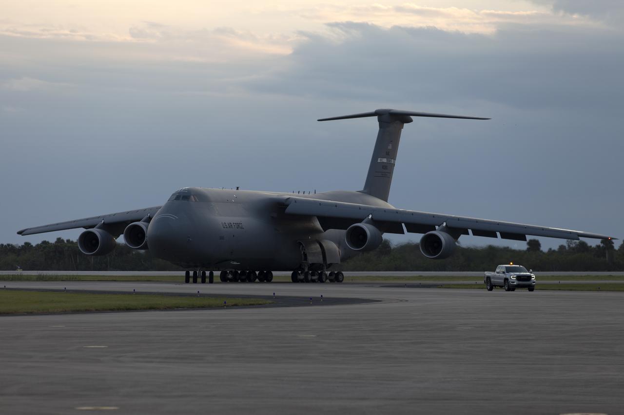
A C-5 transport aircraft arrives at the Shuttle Landing Facility at NASA's Kennedy Space Center in Florida, carrying the Geostationary Operation Environmental Satellite-S (GOES-S). The satellite will be offloaded and transported to the Astrotech Space Operations facility in Titusville, Florida. GOES-S is the second in a series of four advanced geostationary weather satellites. The GOES-R series - consisting of the GOES-R, GOES-S, GOES-T and GOES-U spacecraft - will significantly improve the detection and observation of environmental phenomena that directly affect public safety, protection of property and the nation's economic health and prosperity. GOES-S is slated to launch March 1, 2018 aboard a United Launch Alliance Atlas V rocket from Cape Canaveral Air Force Station in Florida.
NOAA's Geostationary Operation Environmental Satellite-S (GOES-S) is being offloaded from a C-5 transport aircraft onto the flatbed of a heavy-lift truck at the Shuttle Landing Facility at NASA's Kennedy Space Center in Florida. The satellite will be transported to the Astrotech Space Operations facility in Titusville, Florida to prepare it for launch. GOES-S is the second in a series of four advanced geostationary weather satellites. The GOES-R series - consisting of the GOES-R, GOES-S, GOES-T and GOES-U spacecraft - will significantly improve the detection and observation of environmental phenomena that directly affect public safety, protection of property and the nation's economic health and prosperity. GOES-S is slated to launch March 1, 2018 aboard a United Launch Alliance Atlas V rocket from Cape Canaveral Air Force Station in Florida.
A C-5 transport aircraft arrives at the Shuttle Landing Facility at NASA's Kennedy Space Center in Florida, carrying the Geostationary Operation Environmental Satellite-S (GOES-S). The satellite will be offloaded and transported to the Astrotech Space Operations facility in Titusville, Florida. GOES-S is the second in a series of four advanced geostationary weather satellites. The GOES-R series - consisting of the GOES-R, GOES-S, GOES-T and GOES-U spacecraft - will significantly improve the detection and observation of environmental phenomena that directly affect public safety, protection of property and the nation's economic health and prosperity. GOES-S is slated to launch March 1, 2018 aboard a United Launch Alliance Atlas V rocket from Cape Canaveral Air Force Station in Florida.
NOAA's Geostationary Operation Environmental Satellite-S (GOES-S) is being offloaded from a C-5 transport aircraft at the Shuttle Landing Facility at NASA's Kennedy Space Center in Florida. The satellite will be transported to the Astrotech Space Operations facility in Titusville, Florida to prepare it for launch. GOES-S is the second in a series of four advanced geostationary weather satellites. The GOES-R series - consisting of the GOES-R, GOES-S, GOES-T and GOES-U spacecraft - will significantly improve the detection and observation of environmental phenomena that directly affect public safety, protection of property and the nation's economic health and prosperity. GOES-S is slated to launch March 1, 2018 aboard a United Launch Alliance Atlas V rocket from Cape Canaveral Air Force Station in Florida.
NOAA's Geostationary Operation Environmental Satellite-S (GOES-S) has been offloaded from a C-5 transport aircraft and secured onto the flatbed of a heavy-lift truck at the Shuttle Landing Facility at NASA's Kennedy Space Center in Florida. The satellite will be transported to the Astrotech Space Operations facility in Titusville, Florida to prepare it for launch. GOES-S is the second in a series of four advanced geostationary weather satellites. The GOES-R series - consisting of the GOES-R, GOES-S, GOES-T and GOES-U spacecraft - will significantly improve the detection and observation of environmental phenomena that directly affect public safety, protection of property and the nation's economic health and prosperity. GOES-S is slated to launch March 1, 2018 aboard a United Launch Alliance Atlas V rocket from Cape Canaveral Air Force Station in Florida.
A C-5 transport aircraft arrives at the Shuttle Landing Facility at NASA's Kennedy Space Center in Florida, carrying the Geostationary Operation Environmental Satellite-S (GOES-S). The satellite will be offloaded and transported to the Astrotech Space Operations facility in Titusville, Florida. GOES-S is the second in a series of four advanced geostationary weather satellites. The GOES-R series - consisting of the GOES-R, GOES-S, GOES-T and GOES-U spacecraft - will significantly improve the detection and observation of environmental phenomena that directly affect public safety, protection of property and the nation's economic health and prosperity. GOES-S is slated to launch March 1, 2018 aboard a United Launch Alliance Atlas V rocket from Cape Canaveral Air Force Station in Florida.
NOAA's Geostationary Operation Environmental Satellite-S (GOES-S) is being offloaded from a C-5 transport aircraft at the Shuttle Landing Facility at NASA's Kennedy Space Center in Florida. The satellite will be transported to the Astrotech Space Operations facility in Titusville, Florida to prepare it for launch. GOES-S is the second in a series of four advanced geostationary weather satellites. The GOES-R series - consisting of the GOES-R, GOES-S, GOES-T and GOES-U spacecraft - will significantly improve the detection and observation of environmental phenomena that directly affect public safety, protection of property and the nation's economic health and prosperity. GOES-S is slated to launch March 1, 2018 aboard a United Launch Alliance Atlas V rocket from Cape Canaveral Air Force Station in Florida.
41C-02-067 (6-13 April 1984) --- One of the first major accomplishments of Flight 41-C?s crew aboard the Challenger was to place this giant satellite into Earth orbit. Still attached to the remote manipulator system (RMS) end effector, the Long-Duration Exposure Facility (LDEF) is backdropped against Florida, the Bahama Bank, the Gulf of Mexico and Atlantic waters. The multi-colored cylinder carries 50-odd passive scientific experiments representing 194 investigators from around world. The LDEF program is directed by the Langley Research Center in Hampton, Virginia. The facility will be retrieved in a little less than a year by a Space Shuttle crew. This frame was one of the visuals used by the 41-C astronauts for their April 24, 1984 post-flight press conference. Cape Canaveral, where this seven-day mission got its start, and Lake Okeechobee, are easily recognized in the frame, photographed shortly before 11:30 a.m. (CST), April 7, 1984.
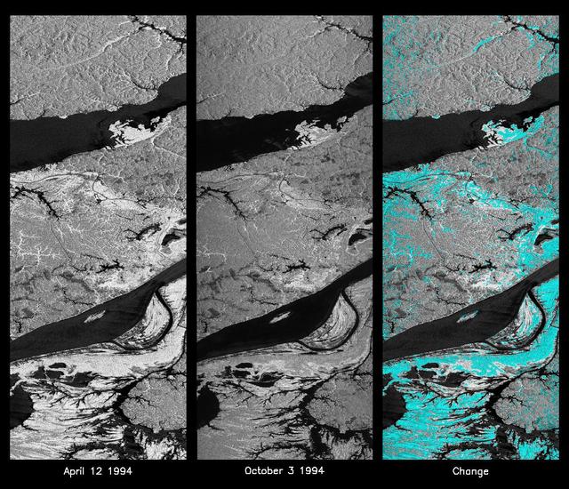
These L-band images of the Manaus region of Brazil were acquired by the Spaceborne Imaging Radar-C and X-band Synthetic Aperture Radar (SIR-C/X-SAR) aboard the space shuttle Endeavour. The left image was acquired on April 12, 1994, and the middle image was acquired on October 3, 1994. The area shown is approximately 8 kilometers by 40 kilometers (5 miles by 25 miles). The two large rivers in this image, the Rio Negro (top) and the Rio Solimoes (bottom), combine at Manaus (west of the image) to form the Amazon River. The image is centered at about 3 degrees south latitude and 61 degrees west longitude. North is toward the top left of the images. The differences in brightness between the images reflect changes in the scattering of the radar channel. In this case, the changes are indicative of flooding. A flooded forest has a higher backscatter at L-band (horizontally transmitted and received) than an unflooded river. The extent of the flooding is much greater in the April image than in the October image, and corresponds to the annual, 10-meter (33-foot) rise and fall of the Amazon River. A third image at right shows the change in the April and October images and was created by determining which areas had significant decreases in the intensity of radar returns. These areas, which appear blue on the third image at right, show the dramatic decrease in the extent of flooded forest, as the level of the Amazon River falls. The flooded forest is a vital habitat for fish and floating meadows are an important source of atmospheric methane. This demonstrates the capability of SIR-C/X-SAR to study important environmental changes that are impossible to see with optical sensors over regions such as the Amazon, where frequent cloud cover and dense forest canopies obscure monitoring of floods. Field studies by boat, on foot and in low-flying aircraft by the University of California at Santa Barbara, in collaboration with Brazil's Instituto Nacional de Pesguisas Estaciais, during the first and second flights of the SIR-C/X-SAR system have validated the interpretation of the radar images. http://photojournal.jpl.nasa.gov/catalog/PIA01740
This is an image showing part of Isla Isabella in the western Galapagos Islands. It was taken by the L-band radar in HH polarization from the Spaceborne Imaging Radar C/X-Band Synthetic Aperture Radar on the 40th orbit of NASA’s space shuttle Endeavour.

S84-43708 (11 Oct 1984) --- These five crewmembers are scheduled to fly aboard the Space Shuttle Challenger for Mission STS-51C, scheduled for January of next year. Astronauts Thomas K. (Ken) Mattingly II (kneeling right) and Loren J. Shriver (kneeling left) are commander and pilot, respectively. Astronauts James F. Buchli (standing center) and Ellison L. Onizuka (right) are mission specialists. Gary E. Payton of the U.S. Air Force, left, is payload specialist. The crewmembers, holding their launch and entry helmets, were photographed with their crew insignia.
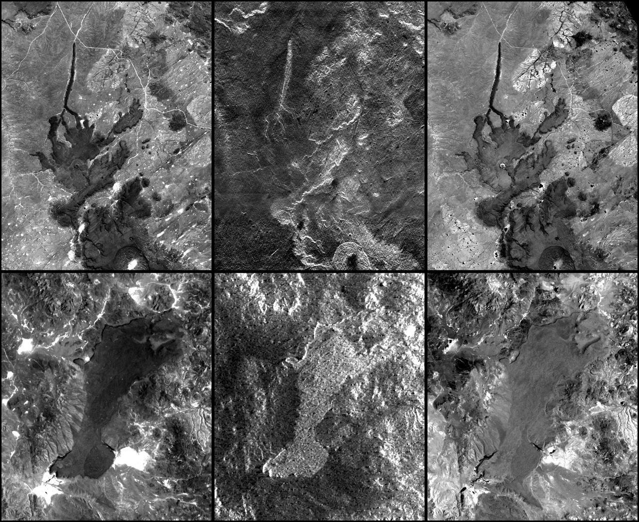
This false-color composite radar image of the Mammoth Mountain area in the Sierra Nevada Mountains, California, was acquired by the Spaceborne Imaging Radar-C and X-band Synthetic Aperture Radar aboard the space shuttle Endeavour on its 67th orbit on October 3, 1994. The image is centered at 37.6 degrees north latitude and 119.0 degrees west longitude. The area is about 39 kilometers by 51 kilometers (24 miles by 31 miles). North is toward the bottom, about 45 degrees to the right. In this image, red was created using L-band (horizontally transmitted/vertically received) polarization data; green was created using C-band (horizontally transmitted/vertically received) polarization data; and blue was created using C-band (horizontally transmitted and received) polarization data. Crawley Lake appears dark at the center left of the image, just above or south of Long Valley. The Mammoth Mountain ski area is visible at the top right of the scene. The red areas correspond to forests, the dark blue areas are bare surfaces and the green areas are short vegetation, mainly brush. The purple areas at the higher elevations in the upper part of the scene are discontinuous patches of snow cover from a September 28 storm. New, very thin snow was falling before and during the second space shuttle pass. In parallel with the operational SIR-C data processing, an experimental effort is being conducted to test SAR data processing using the Jet Propulsion Laboratory's massively parallel supercomputing facility, centered around the Cray Research T3D. These experiments will assess the abilities of large supercomputers to produce high throughput Synthetic Aperture Radar processing in preparation for upcoming data-intensive SAR missions. The image released here was produced as part of this experimental effort. http://photojournal.jpl.nasa.gov/catalog/PIA01746

KENNEDY SPACE CENTER, FLA. - The Return To Flight Task Group (RTFTG) holds the first public meeting at the Debus Center, KSC Visitor Complex. Shown at the table on the left are Dr. Amy K. Donahue, James D. Lloyd, Robert Sieck, retired Air Force Lt. Gen. Forrest C. McCartney, Richard Kohrs, Sy Rubenstein and Dr. Charles C. Daniel. The group is co-chaired by former Shuttle commander Richard O. Covey and retired Air Force Lt. Gen. Thomas P. Stafford, who was an Apollo commander. The RTFTG was at KSC to conduct organizational activities, tour Space Shuttle facilities and receive briefings on Shuttle-related topics. The task group was chartered by NASA Administrator Sean O’Keefe to perform an independent assessment of NASA’s implementation of the final recommendations of the Columbia Accident Investigation Board.
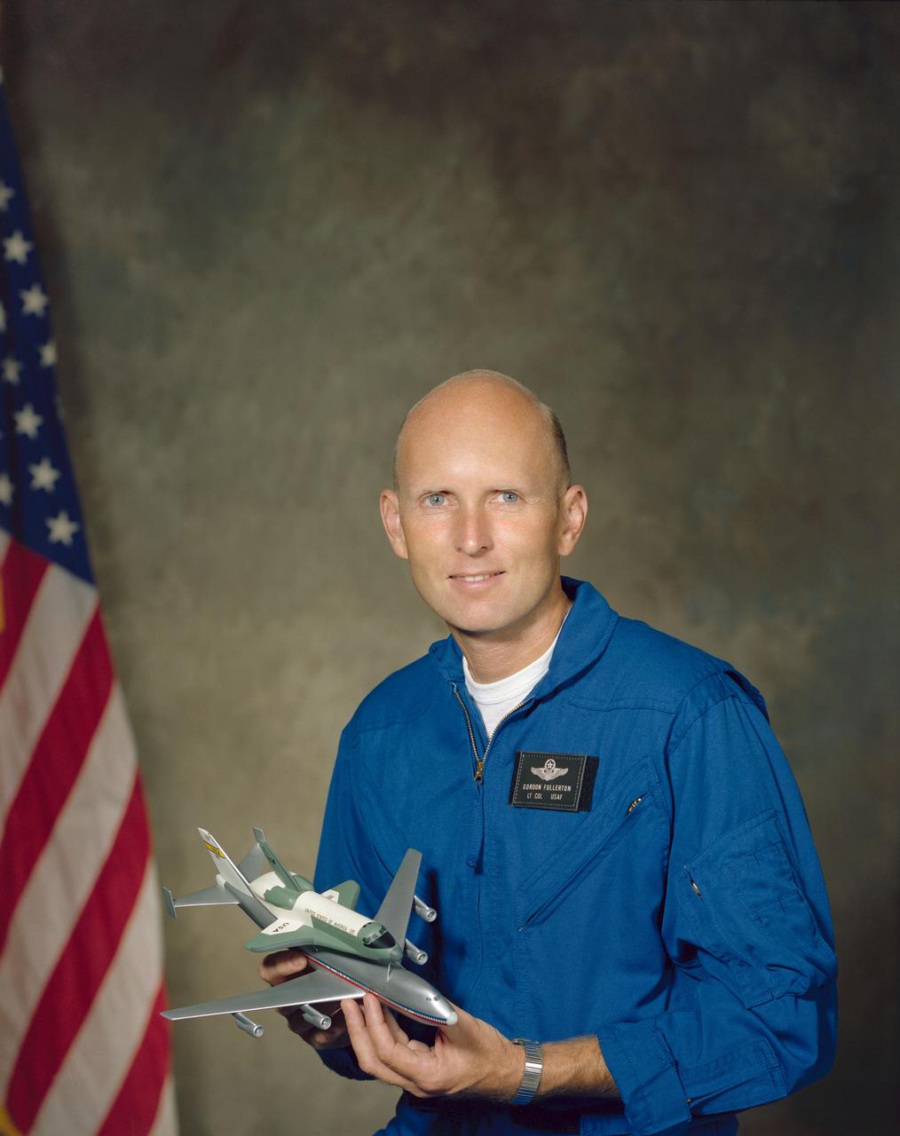
S76-28476 (8 Sept 1976) --- Astronaut C. Gordon Fullerton in flight suit holding a model of the space shuttle.

View of astronaut candidates Daniel C. Brandenstein and Frederick H. Hauck, posed behind model of the Space shuttle orbiter.
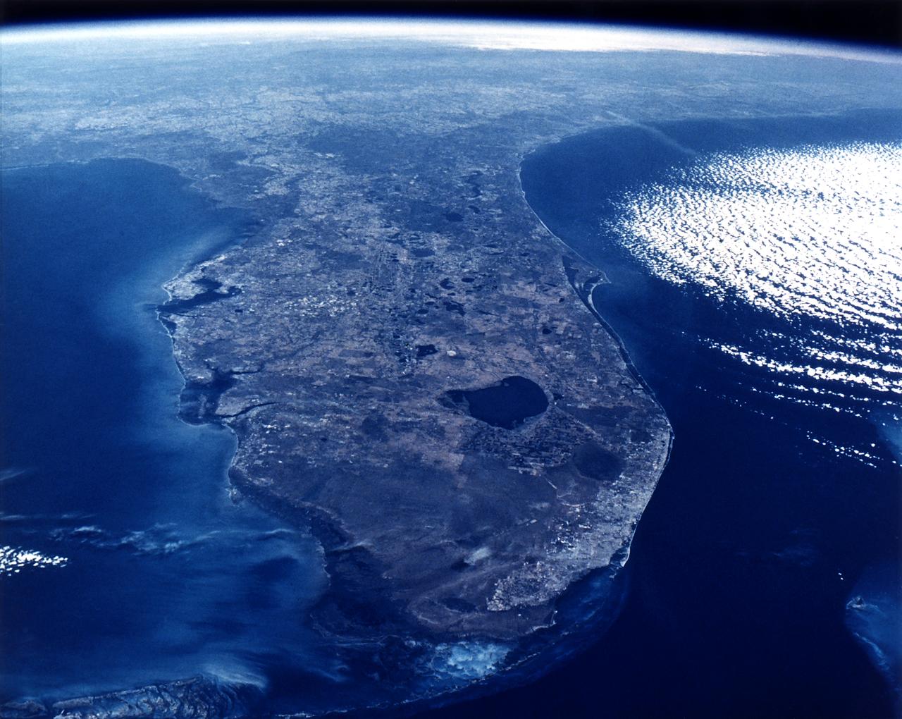
The state of Florida is clearly visible in this photo taken by the crew of space shuttle mission 51-C.
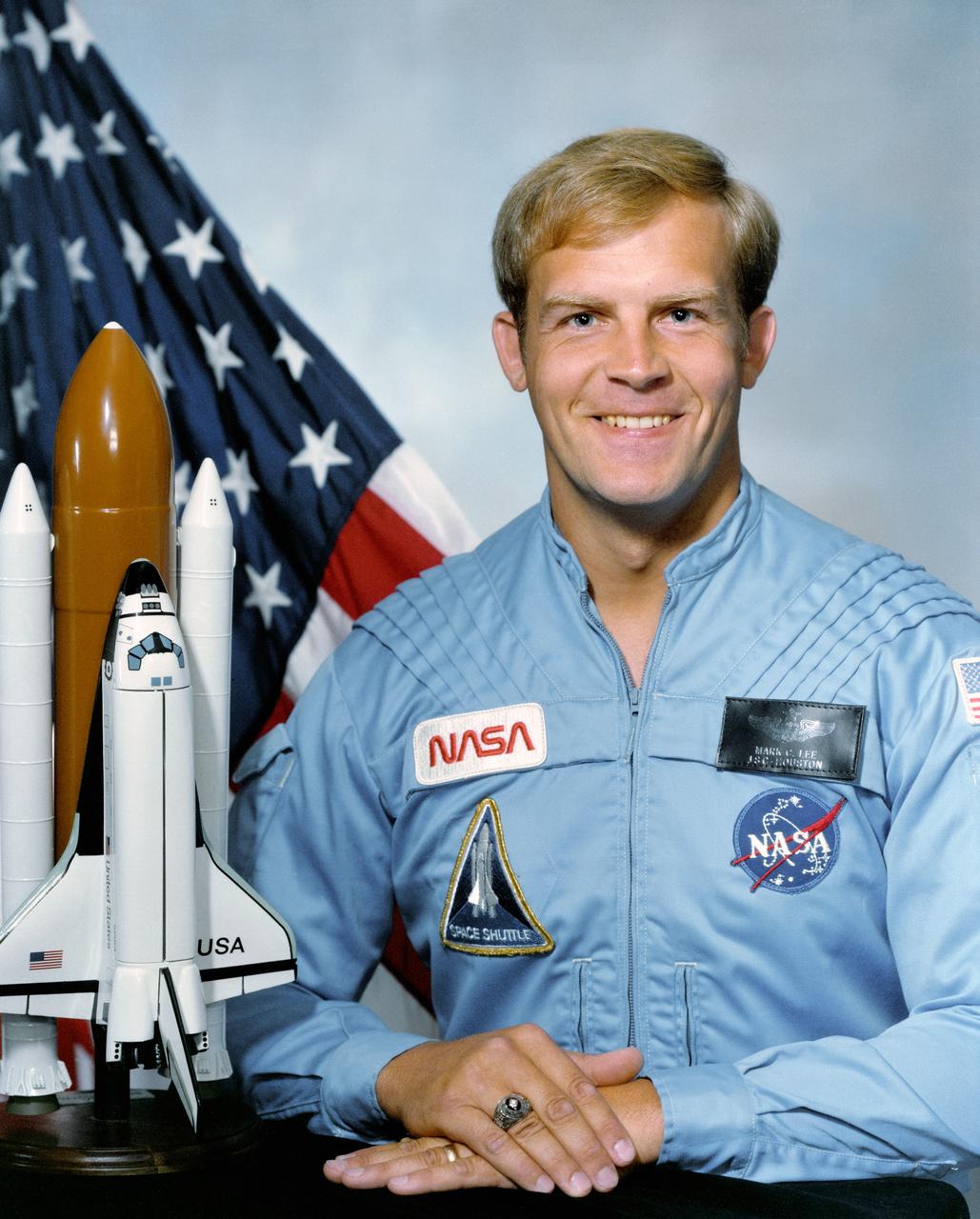
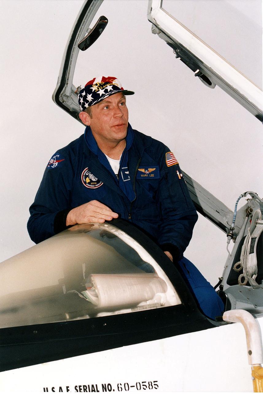
Official portrait photograph of Astronaut Mark C. Lee dressed in blue flight suit, with Flag and a Space Shuttle model (left).
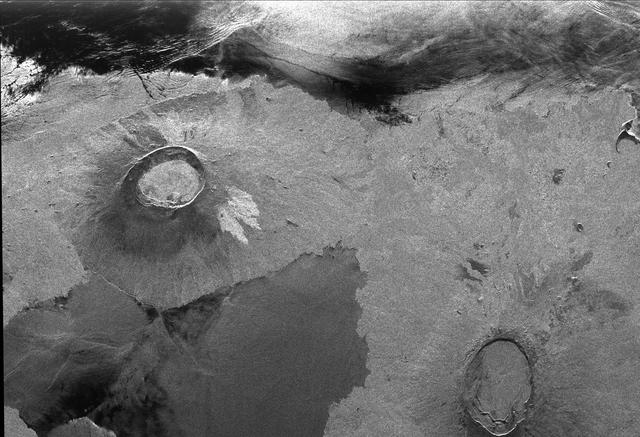
This is a radar image of a little known volcano in northern Colombia. The image was acquired on orbit 80 of space shuttle Endeavour on April 14, 1994, by NASA Spaceborne Imaging Radar C/X-Band Synthetic Aperture Radar SIR-C/X-SAR. The volcano near the center of the image is located at 5.6 degrees north latitude, 75.0 degrees west longitude, about 100 kilometers (65 miles) southeast of Medellin, Colombia. The conspicuous dark spot is a lake at the bottom of an approximately 3-kilometer-wide (1.9-mile) volcanic collapse depression or caldera. A cone-shaped peak on the bottom left (northeast rim) of the caldera appears to have been the source for a flow of material into the caldera. This is the northern-most known volcano in South America and because of its youthful appearance, should be considered dormant rather than extinct. The volcano's existence confirms a fracture zone proposed in 1985 as the northern boundary of volcanism in the Andes. The SIR-C/X-SAR image reveals another, older caldera further south in Colombia, along another proposed fracture zone. Although relatively conspicuous, these volcanoes have escaped widespread recognition because of frequent cloud cover that hinders remote sensing imaging in visible wavelengths. Four separate volcanoes in the Northern Andes nations of Colombia and Ecuador have been active during the last 10 years, killing more than 25,000 people, including scientists who were monitoring the volcanic activity. Detection and monitoring of volcanoes from space provides a safe way to investigate volcanism. The recognition of previously unknown volcanoes is important for hazard evaluations because a number of major eruptions this century have occurred at mountains that were not previously recognized as volcanoes. http://photojournal.jpl.nasa.gov/catalog/PIA01722
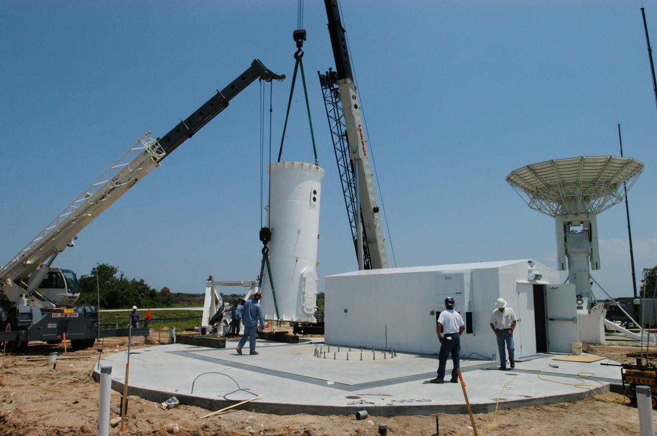
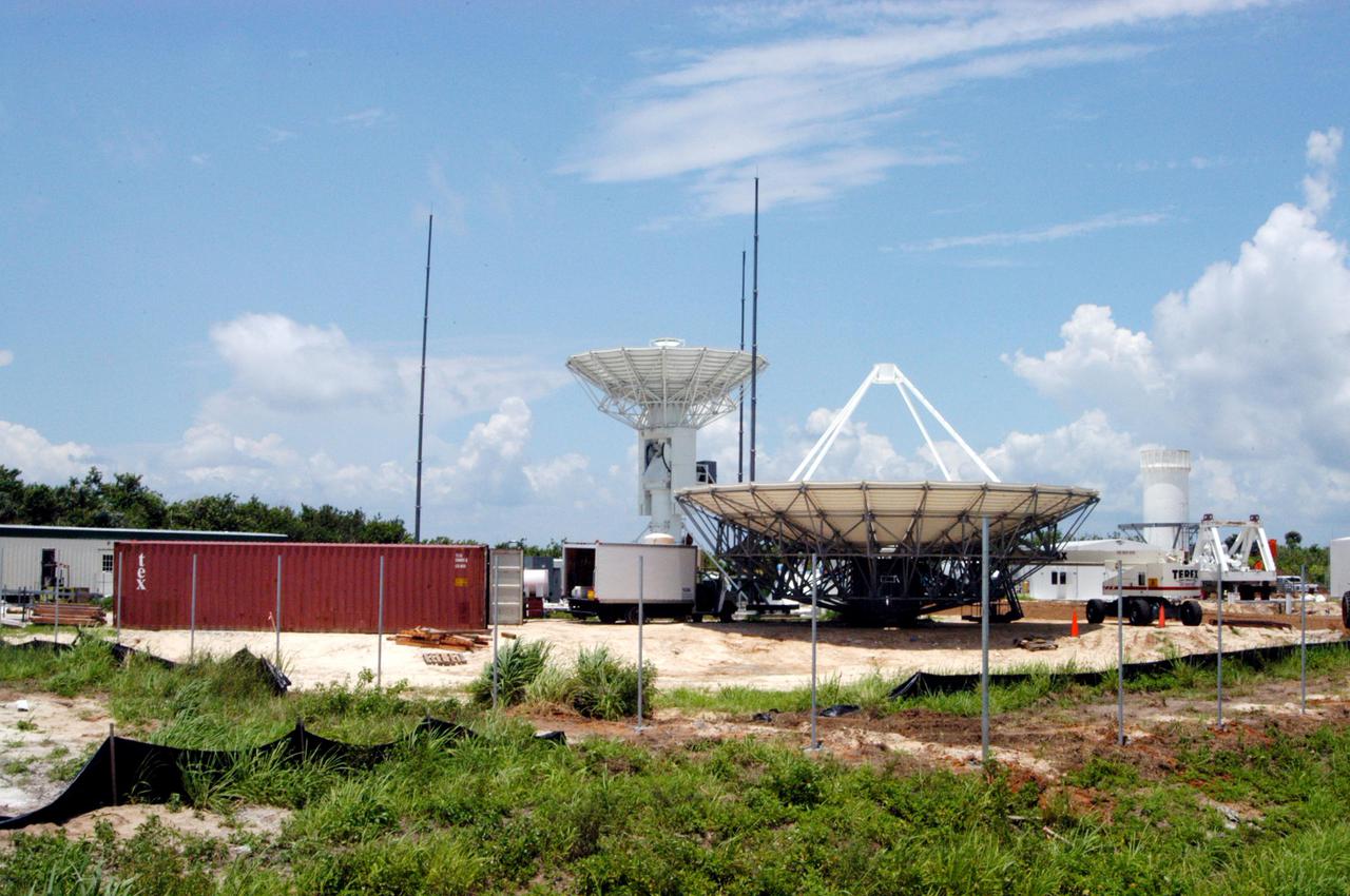
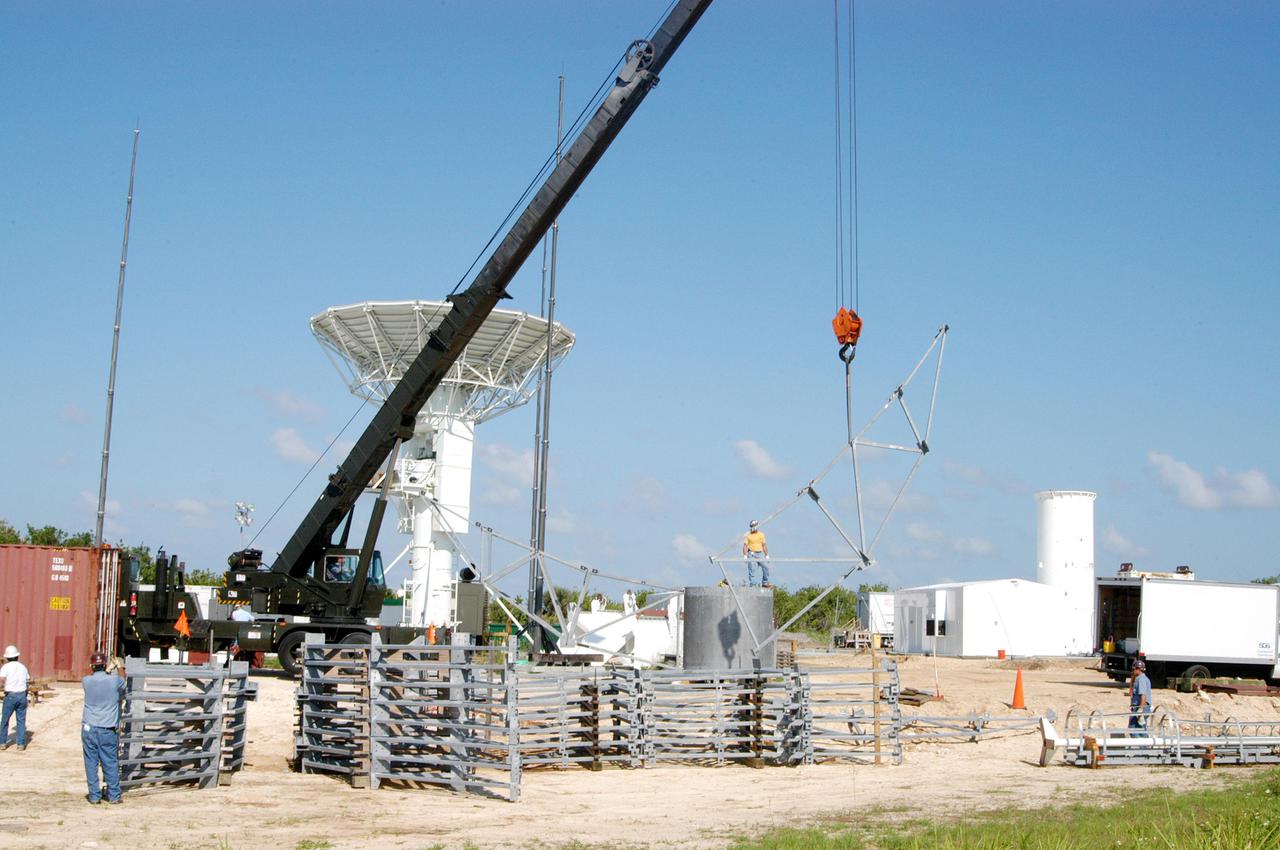
KENNEDY SPACE CENTER, FLA. - Equipment is delivered for installation of another NASA C-band radar at a radar site on North Merritt Island, Fla. The 50-foot C-band radar will be used for long-term Shuttle missions to track the launches and observe possible debris coming from the Shuttle. In the background is an existing 30-foot C-band Pathfinder radar whose use was demonstrated on the Delta Messenger launch. It will be used on the upcoming two Return to Flight missions. The launch window for the first Return to Flight mission, STS-114, is July 13 to July 31.
KENNEDY SPACE CENTER, FLA. - Equipment is delivered for installation of another NASA C-band radar at a radar site on North Merritt Island, Fla. The 50-foot C-band radar will be used for long-term Shuttle missions to track the launches and observe possible debris coming from the Shuttle. In the background is an existing 30-foot C-band Pathfinder radar whose use was demonstrated on the Delta Messenger launch. It will be used on the upcoming two Return to Flight missions. The launch window for the first Return to Flight mission, STS-114, is July 13 to July 31.
KENNEDY SPACE CENTER, FLA. - Equipment is delivered for installation of another NASA C-band radar at a radar site on North Merritt Island, Fla. The 50-foot C-band radar will be used for long-term Shuttle missions to track the launches and observe possible debris coming from the Shuttle. In the background is an existing 30-foot C-band Pathfinder radar whose use was demonstrated on the Delta Messenger launch. It will be used on the upcoming two Return to Flight missions. The launch window for the first Return to Flight mission, STS-114, is July 13 to July 31.
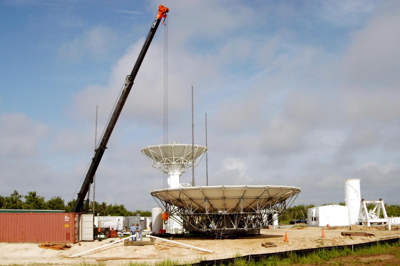
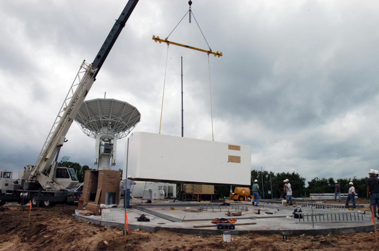
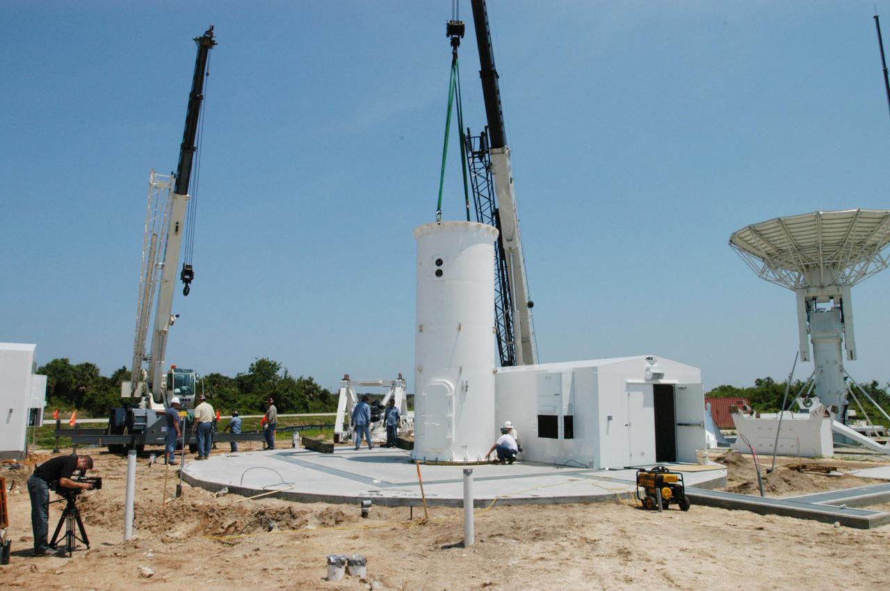
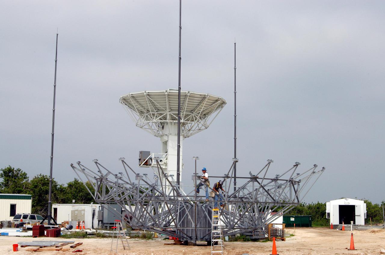
KENNEDY SPACE CENTER, FLA. - On June 6, progress is made in the erection of a C-band radar antenna at a radar site on North Merritt Island, Fla. The 50-foot C-band radar will be used for long-term Shuttle missions to track the launches and observe possible debris coming from the Shuttle. In the background is an existing 30-foot C-band Pathfinder radar whose use was demonstrated on the Delta Messenger launch. It will be used on the upcoming two Return to Flight missions. The launch window for the first Return to Flight mission, STS-114, is July 13 to July 31.

KENNEDY SPACE CENTER, FLA. - On June 13, the base for a C-band radar antenna (seen at left) can be seen under construction (at right) on a radar site on North Merritt Island, Fla. The 50-foot C-band radar will be used for long-term Shuttle missions to track the launches and observe possible debris coming from the Shuttle. In the background (center) is an existing 30-foot C-band Pathfinder radar whose use was demonstrated on the Delta Messenger launch. It will be used on the upcoming two Return to Flight missions. The launch window for the first Return to Flight mission, STS-114, is July 13 to July 31.
KENNEDY SPACE CENTER, FLA. - On June 8, further progress is made in the erection of a C-band radar antenna at a radar site on North Merritt Island, Fla. The 50-foot C-band radar will be used for long-term Shuttle missions to track the launches and observe possible debris coming from the Shuttle. In the background is an existing 30-foot C-band Pathfinder radar whose use was demonstrated on the Delta Messenger launch. It will be used on the upcoming two Return to Flight missions. The launch window for the first Return to Flight mission, STS-114, is July 13 to July 31.
KENNEDY SPACE CENTER, FLA. - Equipment is delivered for installation of another NASA C-band radar at a radar site on North Merritt Island, Fla. The 50-foot C-band radar will be used for long-term Shuttle missions to track the launches and observe possible debris coming from the Shuttle. In the background is an existing 30-foot C-band Pathfinder radar whose use was demonstrated on the Delta Messenger launch. It will be used on the upcoming two Return to Flight missions. The launch window for the first Return to Flight mission, STS-114, is July 13 to July 31.
KENNEDY SPACE CENTER, FLA. - On June 14, work is underway on a radar site on North Merritt Island, Fla., constructing a C-band radar antenna (seen at left) and its base. The 50-foot C-band radar will be used for long-term Shuttle missions to track the launches and observe possible debris coming from the Shuttle. In the background (center) is an existing 30-foot C-band Pathfinder radar whose use was demonstrated on the Delta Messenger launch. It will be used on the upcoming two Return to Flight missions. The launch window for the first Return to Flight mission, STS-114, is July 13 to July 31.
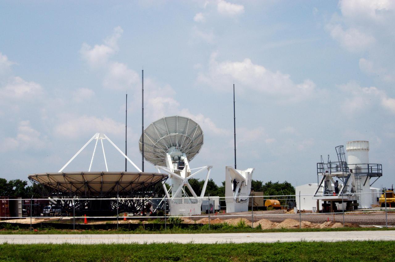
KENNEDY SPACE CENTER, FLA. - On June 16, work is underway on a radar site on North Merritt Island, Fla., constructing a C-band radar antenna (seen at left) and its base. The 50-foot C-band radar will be used for long-term Shuttle missions to track the launches and observe possible debris coming from the Shuttle. In the background (center) is an existing 30-foot C-band Pathfinder radar whose use was demonstrated on the Delta Messenger launch. It will be used on the upcoming two Return to Flight missions. The launch window for the first Return to Flight mission, STS-114, is July 13 to July 31.
KENNEDY SPACE CENTER, FLA. - Equipment is delivered for installation of another NASA C-band radar at a radar site on North Merritt Island, Fla. The 50-foot C-band radar will be used for long-term Shuttle missions to track the launches and observe possible debris coming from the Shuttle. In the background is an existing 30-foot C-band Pathfinder radar whose use was demonstrated on the Delta Messenger launch. It will be used on the upcoming two Return to Flight missions. The launch window for the first Return to Flight mission, STS-114, is July 13 to July 31.

KENNEDY SPACE CENTER, FLA. - Equipment is delivered for installation of another NASA C-band radar at a radar site on North Merritt Island, Fla. The 50-foot C-band radar will be used for long-term Shuttle missions to track the launches and observe possible debris coming from the Shuttle. In the background is an existing 30-foot C-band Pathfinder radar whose use was demonstrated on the Delta Messenger launch. It will be used on the upcoming two Return to Flight missions. The launch window for the first Return to Flight mission, STS-114, is July 13 to July 31.
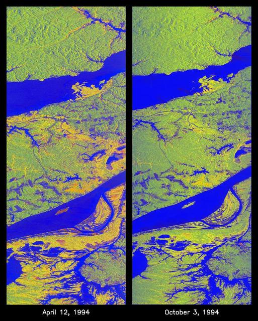
These two false-color images of the Manaus region of Brazil in South America were acquired by the Spaceborne Imaging Radar-C and X-band Synthetic Aperture Radar on board the space shuttle Endeavour. The image at left was acquired on April 12, 1994, and the image at right was acquired on October 3, 1994. The area shown is approximately 8 kilometers by 40 kilometers (5 miles by 25 miles). The two large rivers in this image, the Rio Negro (at top) and the Rio Solimoes (at bottom), combine at Manaus (west of the image) to form the Amazon River. The image is centered at about 3 degrees south latitude and 61 degrees west longitude. North is toward the top left of the images. The false colors were created by displaying three L-band polarization channels: red areas correspond to high backscatter, horizontally transmitted and received, while green areas correspond to high backscatter, horizontally transmitted and vertically received. Blue areas show low returns at vertical transmit/receive polarization; hence the bright blue colors of the smooth river surfaces can be seen. Using this color scheme, green areas in the image are heavily forested, while blue areas are either cleared forest or open water. The yellow and red areas are flooded forest or floating meadows. The extent of the flooding is much greater in the April image than in the October image and appears to follow the 10-meter (33-foot) annual rise and fall of the Amazon River. The flooded forest is a vital habitat for fish, and floating meadows are an important source of atmospheric methane. These images demonstrate the capability of SIR-C/X-SAR to study important environmental changes that are impossible to see with optical sensors over regions such as the Amazon, where frequent cloud cover and dense forest canopies block monitoring of flooding. Field studies by boat, on foot and in low-flying aircraft by the University of California at Santa Barbara, in collaboration with Brazil's Instituto Nacional de Pesguisas Estaciais, during the first and second flights of the SIR-C/X-SAR system have validated the interpretation of the radar images. http://photojournal.jpl.nasa.gov/catalog/PIA01735
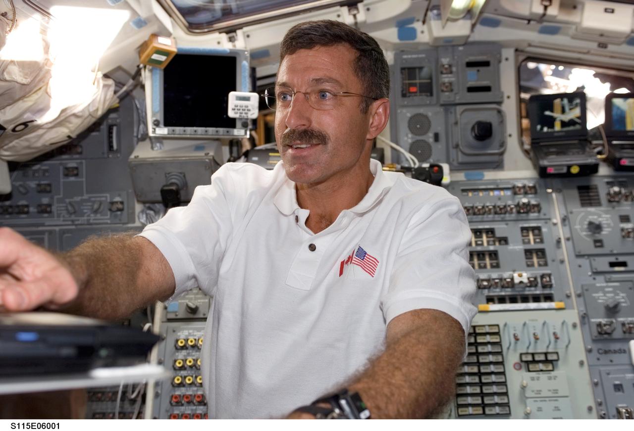
S115-E-06001 (14 Sept. 2006) --- Astronaut Daniel C. Burbank, STS-115 mission specialist, works on the aft flight deck of the Space Shuttle Atlantis during the sixth day in space for the shuttle crew.
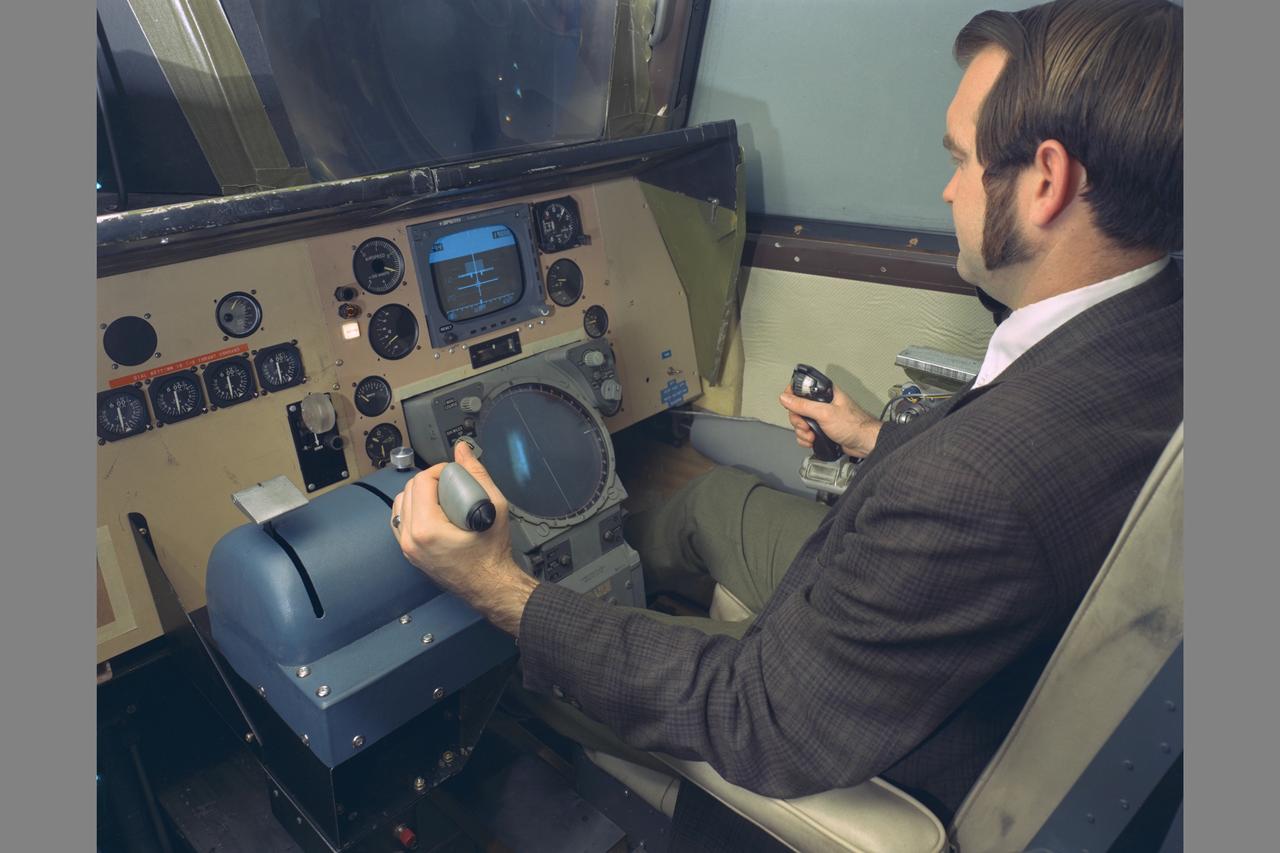
PILOT KENNETH C. WHITE IN CHAIR. Space Shuttle Vehicle Simulation. SSV COCKPIT IN THE MOVING-CAB TRANSPORT SIMULATOR (S.16)

As white room closeout members look on, STS-82 Payload Commander Mark. C. Lee prepares to enter the Space Shuttle Discovery at Launch Pad 39A
KENNEDY SPACE CENTER, FLA. - On June 8, the base for a C-band radar antenna is being constructed at a radar site on North Merritt Island, Fla. The 50-foot C-band radar will be used for long-term Shuttle missions to track the launches and observe possible debris coming from the Shuttle. The launch window for the first Return to Flight mission, STS-114, is July 13 to July 31.
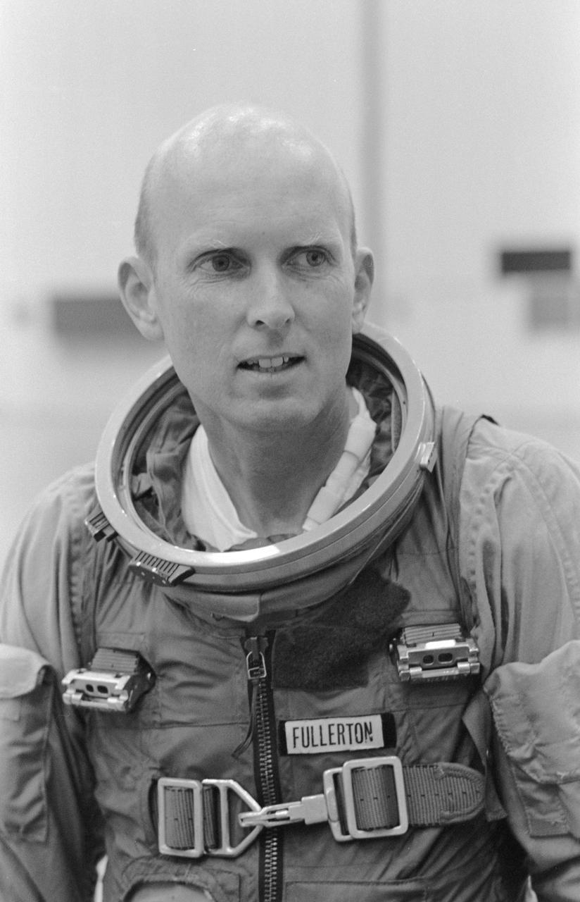
S78-34917 (31 Aug. 1978) --- Just about to don his helmet and enter JSC?s shuttle engineering mock-up/trainer is astronaut C. Gordon Fullerton, one of eight NASA astronauts recently named to man the space shuttle Columbia on a series of orbital flight tests in the early 1980s. Photo credit: NASA NOTE: Since this photograph was made, astronaut C. Gordon Fullerton was named pilot for STS-3, scheduled for launch in early spring of 1982.
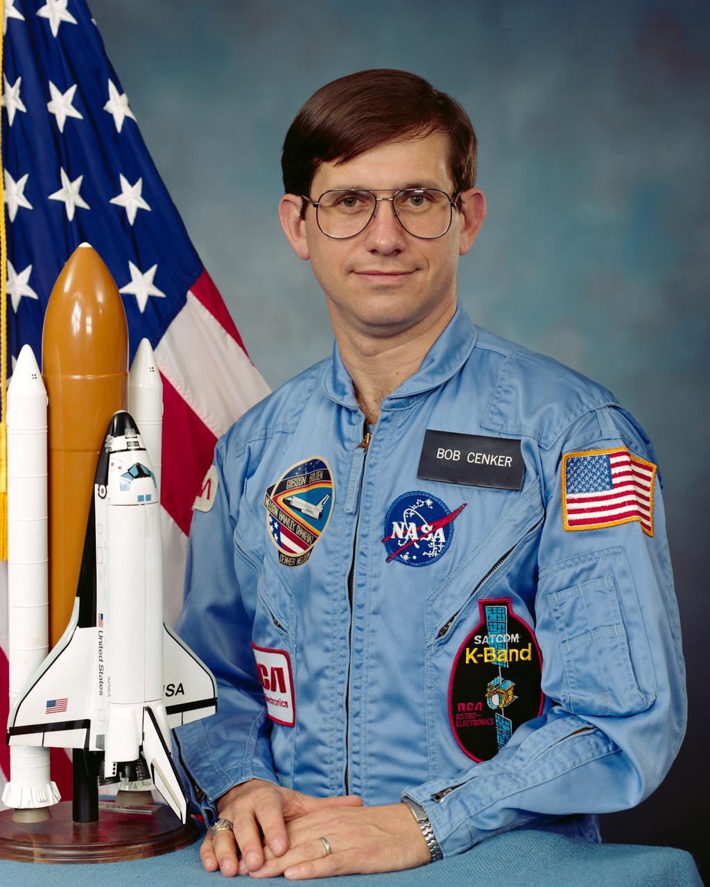
S85-45499 (2 Dec 1985) --- Payload specialist Robert J. Cenker.
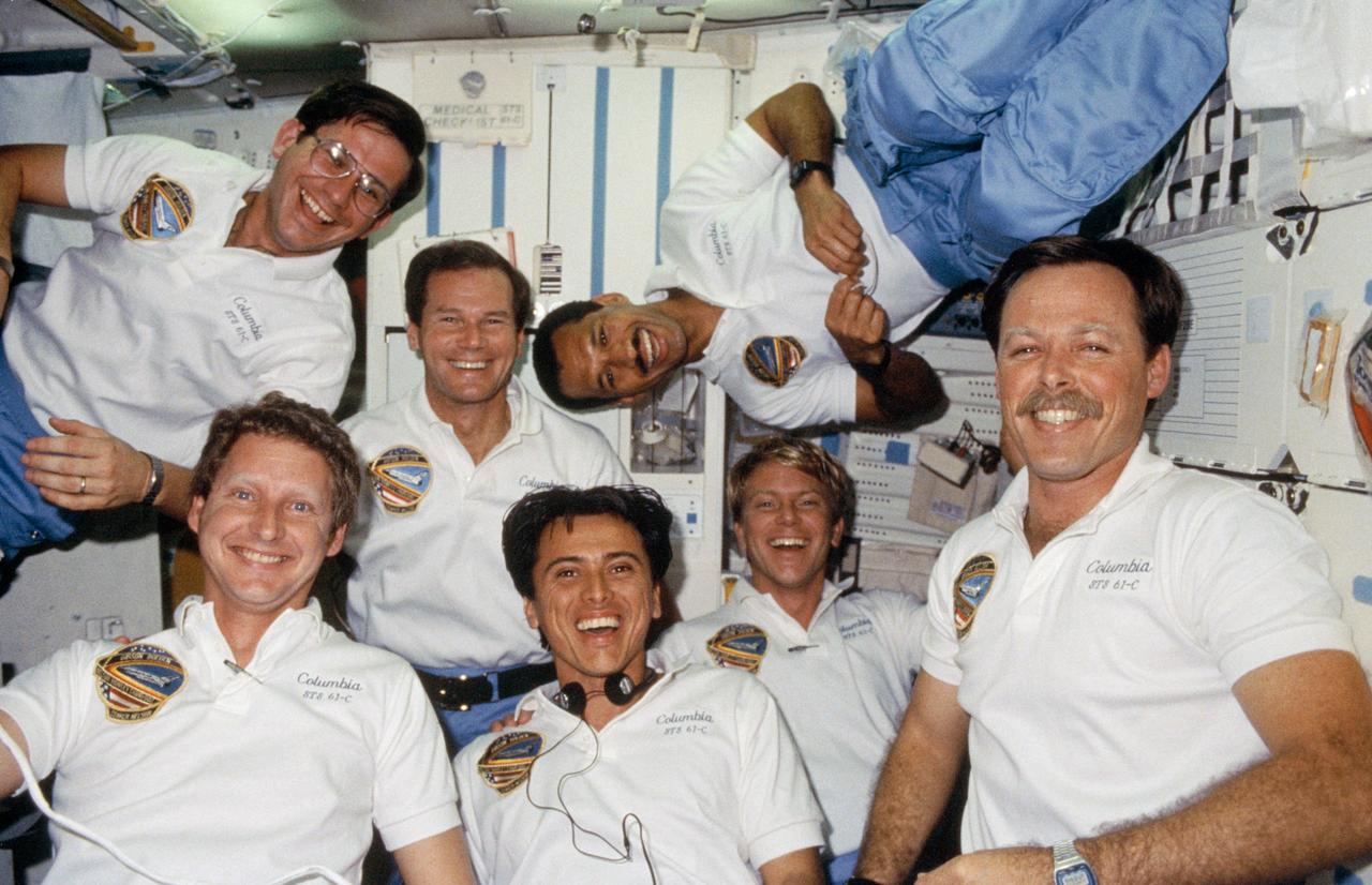
61C-14-008 (12-18 Jan. 1986) --- The seven crew members for STS-61C mission use the space shuttle Columbia's middeck for the traditional in-flight group portrait. Astronaut Robert L. Gibson (lower right corner), commander, is surrounded by fellow crew members, counter-clockwise from upper right: astronaut Charles F. Bolden, pilot; U.S. Representative Bill Nelson (D., Florida), payload specialist; Robert J. Cenker, RCA payload specialist; and astronauts Steven A. Hawley, Franklin R. Chang-Diaz and George D. Nelson, all mission specialists. Photo credit: NASA
51C-08-017 (24-27 Jan 1985) --- Astronaut Ellison S. Onizuka, mission specialist, (left) turns 180 degrees near airlock hatch, while Loren J. Shriver, pilot, records verbal mission - pertinent notes. For orientation hold the picture with lockers on right.
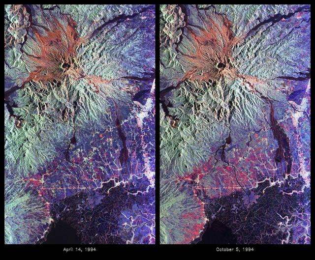
These are color composite radar images showing the area around Mount Pinatubo in the Philippines. The images were acquired by the Spaceborne Imaging Radar-C and X-band Synthetic Aperture Radar (SIR-C/X-SAR) aboard the space shuttle Endeavour on April 14, 1994 (left image) and October 5,1994 (right image). The images are centered at about 15 degrees north latitude and 120.5 degrees east longitude. Both images were obtained with the same viewing geometry. The color composites were made by displaying the L-band (horizontally transmitted and received) in red; the L-band (horizontally transmitted and vertically received) in green; and the C-band (horizontally transmitted and vertically received) in blue. The area shown is approximately 40 kilometers by 65 kilometers (25 miles by 40 miles). The main volcanic crater on Mount Pinatubo produced by the June 1991 eruptions and the steep slopes on the upper flanks of the volcano are easily seen in these images. Red on the high slopes shows the distribution of the ash deposited during the 1991 eruption, which appears red because of the low cross-polarized radar returns at C and L bands. The dark drainages radiating away from the summit are the smooth mudflows, which even three years after the eruptions continue to flood the river valleys after heavy rain. Comparing the two images shows that significant changes have occurred in the intervening five months along the Pasig-Potrero rivers (the dark area in the lower right of the images). Mudflows, called "lahars," that occurred during the 1994 monsoon season filled the river valleys, allowing the lahars to spread over the surrounding countryside. Three weeks before the second image was obtained, devastating lahars more than doubled the area affected in the Pasig-Potrero rivers, which is clearly visible as the increase in dark area on the lower right of the images. Migration of deposition to the east (right) has affected many communities. Newly affected areas included the community of Bacolor, Pampanga, where thousands of homes were buried in meters of hot mud and rock as 80,000 people fled the lahar-stricken area. Scientists are closely monitoring the westward migration ( toward the left in this image) of the lahars as the Pasig-Potrero rivers seek to join with the Porac River, an area that has not seen laharic activity since the eruption. This could be devastating because the Pasig-Potrero rivers might be permanently redirected to lower elevations along the Porac River where communities are located. Ground saturation with water during the rainy season reveals inactive channels that were dry in the April image. A small lake has turned into a pond in the lower reaches of the Potrero River because the channels are full of lahar deposits and the surface runoff has no where to flow. Changes in the degree of erosion in ash and pumice deposits from the 1991 eruption can also be seen in the channels that deliver the mudflow material to the Pasig-Potrero rivers. The 1991 Mount Pinatubo eruption is well known for its near-global effects on the atmosphere and short-term climate due to the large amount of sulfur dioxide that was injected into the upper atmosphere. Locally, however, the effects will most likely continue to impact surrounding areas for as long as the next 10 to 15 years. Mudflows, quite certainly, will continue to pose severe hazards to adjacent areas. Radar observations like those obtained by SIR-C/X-SAR will play a key role in monitoring these changes because of the radar's ability to see in daylight or darkness and even in the worst weather conditions. Radar imaging will be particularly useful, for example, during the monsoon season, when the lahars form. Frequent imaging of these lahar fields will allow scientists to better predict when they are likely to begin flowing again and which communities might be at risk. http://photojournal.jpl.nasa.gov/catalog/PIA01743
STS059-S-084 (17 April 1994) --- This is a three-dimensional perspective of Mammoth Mountain, California. This view was constructed by overlaying a SIR-C radar image on a U.S. Geological Survey digital elevation map. Vertical exaggeration is 2x. The image is centered at 37.6 degrees north, 119.0 degrees west. It was acquired from the Spaceborne Imaging Radar-C and X-Band Synthetic Aperture Radar (SIR-C/X-SAR) onboard the Space Shuttle Endeavour on its 67th orbit, April 13, 1994. In this color representation, red is C-Band HV-polarization, green is C-Band VV-polarization and blue is the ratio of C-Band VV to C-Band HV. Blue areas are smooth and yellow areas are rock outcrops with varying amounts of snow and vegetation. Crowley Lake is in the foreground and Highway 395 crosses in the middle of the image. Mammoth Mountain is shown in the upper right. SIR-C/X-SAR is part of NASA's Mission to Planet Earth (MTPE). SIR-C/X-SAR radars illuminate Earth with microwaves allowing detailed observations at any time, regardless of weather or sunlight conditions. SIR-C/X-SAR uses three microwave wavelengths: L-Band (24 cm), C-Band (6 cm), and X-Band (3 cm). The multi-frequency data will be used by the international scientific community to better understand the global environment and how it is changing. The SIR-C/X-SAR data, complemented by aircraft and ground studies, will give scientists clearer insights into those environmental changes which are caused by nature and those changes which are induced by human activity. SIR-C was developed by NASA's Jet Propulsion Laboratory (JPL). X-SAR was developed by the Dornire and Alenia Spazio Companies for the German Space Agency, Deutsche Agentur fuer Raumfahrtangelegenheiten (DARA), and the Italian Space Agency, Agenzia Spaziale Italiana (ASI). JPL Photo ID: P-43933
KENNEDY SPACE CENTER, FLA. - STS-82 Payload Commander Mark C. Lee prepares to step down from the T-38 jet he flew from an air field serving the astronauts' home base at Johnson Space Center, Houston, Texas, to KSC's Shuttle Landing Facility. Lee and the other six members of the STS-82 crew will spend the last few days before launch at KSC. STS-82 is scheduled for liftoff on Feb. 11 during a 65-minute launch window that opens at 3:56 a.m. EST. The 10-day flight aboard the Space Shuttle Discovery will be the second Hubble Space Telescope (HST) servicing mission.
JSC2009-E-084158 (16 April 2009) --- Astronaut Gregory C. Johnson, STS-125 pilot, flies a Shuttle Training Aircraft (STA) over Edwards Air Force Base, California, during a training session.
STS106-375-008 (8-20 September 2000) --- Astronaut Daniel C. Burbank, mission specialist, prepares to photograph the departing International Space Station through the overhead windows on the aft flight deck of the Space Shuttle Atlantis.
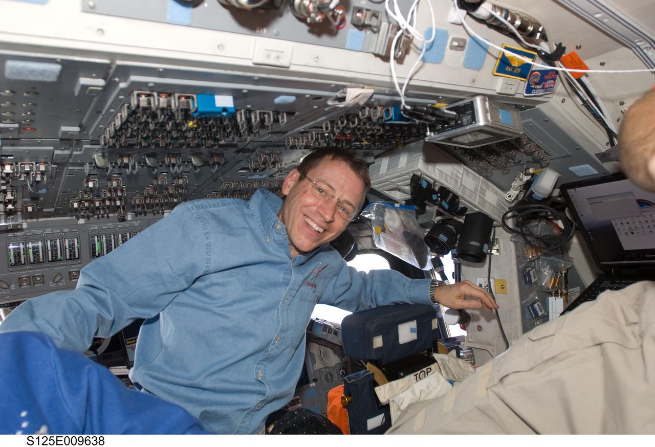
S125-E-009638 (18 May 2009) --- Astronaut Gregory C. Johnson, STS-125 pilot, is pictured on the flight deck of the Earth-orbiting Space Shuttle Atlantis during flight day eight activities.
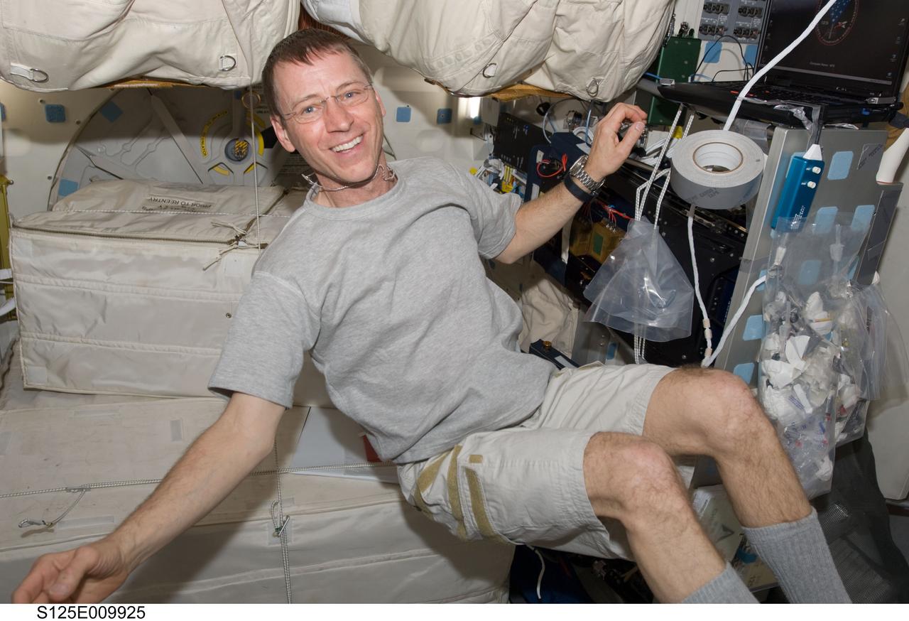
S125-E-009925 (18 May 2009) --- Astronaut Gregory C. Johnson, STS-125 pilot, is pictured on the middeck of the Earth-orbiting Space Shuttle Atlantis during flight day eight activities.
S125-E-013369 (21 May 2009) --- Astronaut Gregory C. Johnson, STS-125 pilot, uses a vacuum cleaner to remove dust particles from the air filter system on the flight deck of Space Shuttle Atlantis.
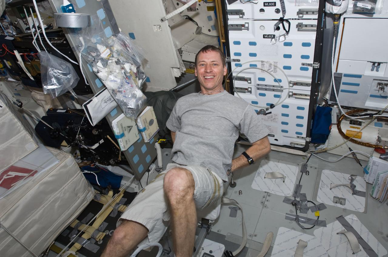
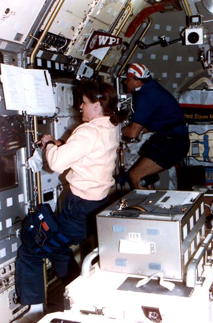
S125-E-009943 (18 May 2009) --- Astronaut Gregory C. Johnson, STS-125 pilot, exercises on the bicycle ergometer on the middeck of the Earth-orbiting Space Shuttle Atlantis.

S106-E-5226 (15 September 2000) --- Astronaut Daniel C. Burbank, mission specialist, temporarily occupies the commander's station on the flight deck of the Space Shuttle Atlantis during late Flight Day 6 activity.
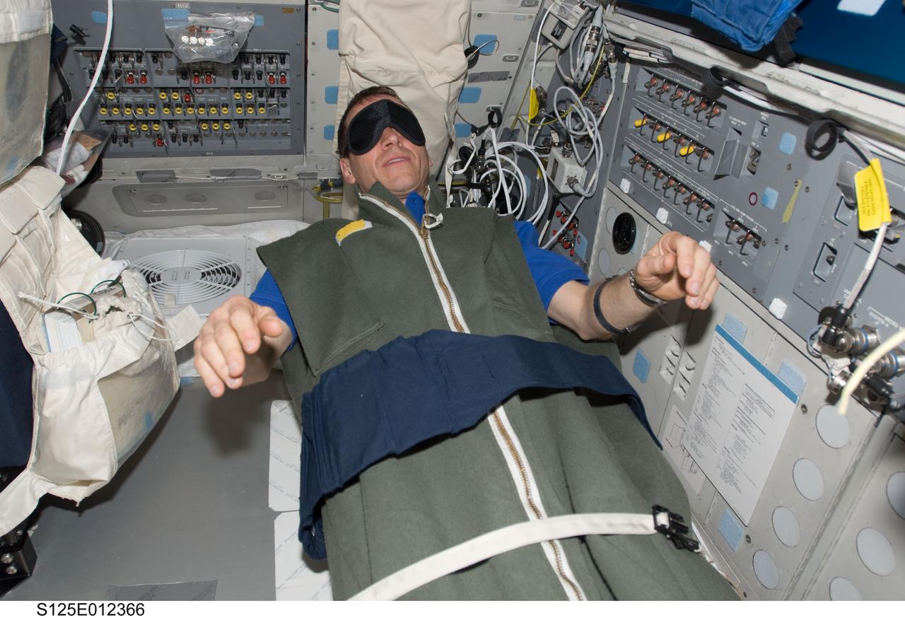
S125-E-012366 (20 May 2009) --- Astronaut Gregory C. Johnson, STS-125 pilot, rests in his sleeping bag on the flight deck of the Earth-orbiting Space Shuttle Atlantis at the end of flight day 10.
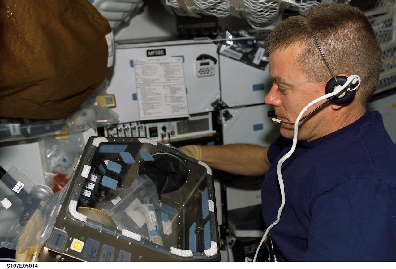
STS107-E-05014 (17 January 2003) --- Astronaut William C. McCool, STS-107 pilot, works with supportive gear for experiments on the SPACEHAB Research Double Module aboard the Space Shuttle Columbia.
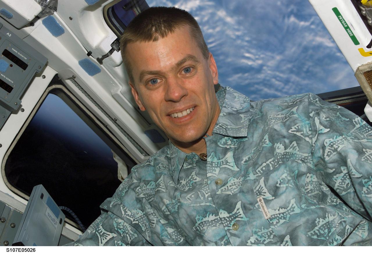
STS107-E-05026 (18 January 2003) --- Astronaut William C. McCool, STS-107 pilot, is pictured on the aft flight deck of the Earth-orbiting Space Shuttle Columbia.
S115-E-05317 (10 Sept. 2006) --- Astronaut Daniel C. Burbank, STS-115 mission specialist, works with controls on the aft flight deck of the Space Shuttle Atlantis during activities on the second flight day.
Astronaut Kathryn C. Thornton, payload commander for STS-73, works at the drop physics module (DPM) on the portside of the science module aboard the Space Shuttle Columbia in Earth orbit.
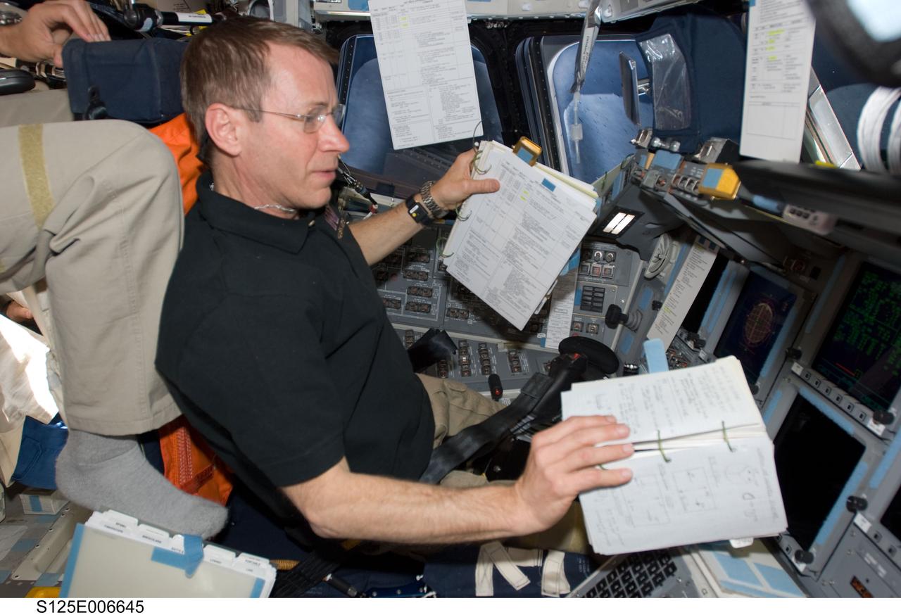
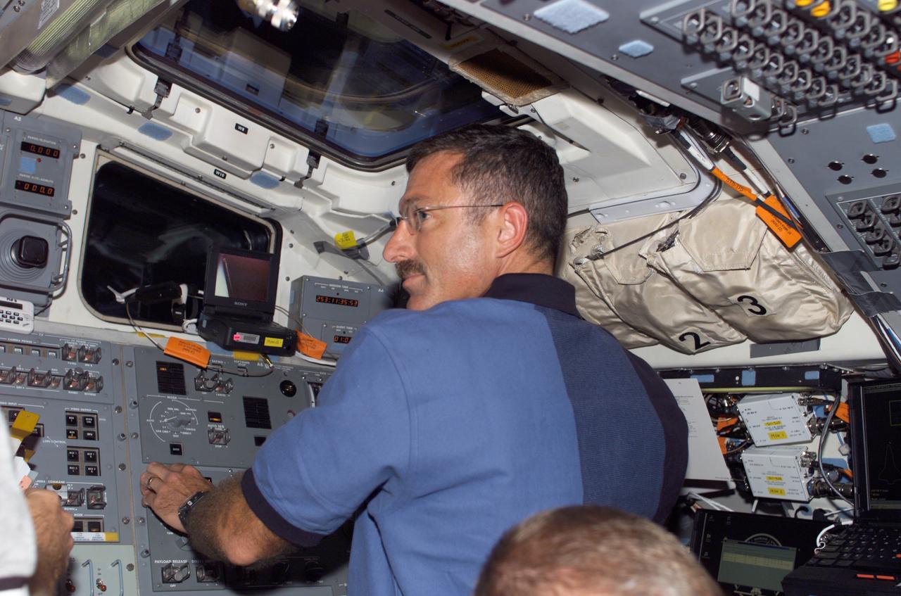
S125-E-006645 (13 May 2009) --- Astronaut Gregory C. Johnson, STS-125 pilot, occupies the commander?s station on the flight deck of Space Shuttle Atlantis during flight day three activities.

JSC2009-E-084157 (16 April 2009) --- Astronaut Gregory C. Johnson, STS-125 pilot, flies a Shuttle Training Aircraft (STA) over Edwards Air Force Base, California, during a training session.
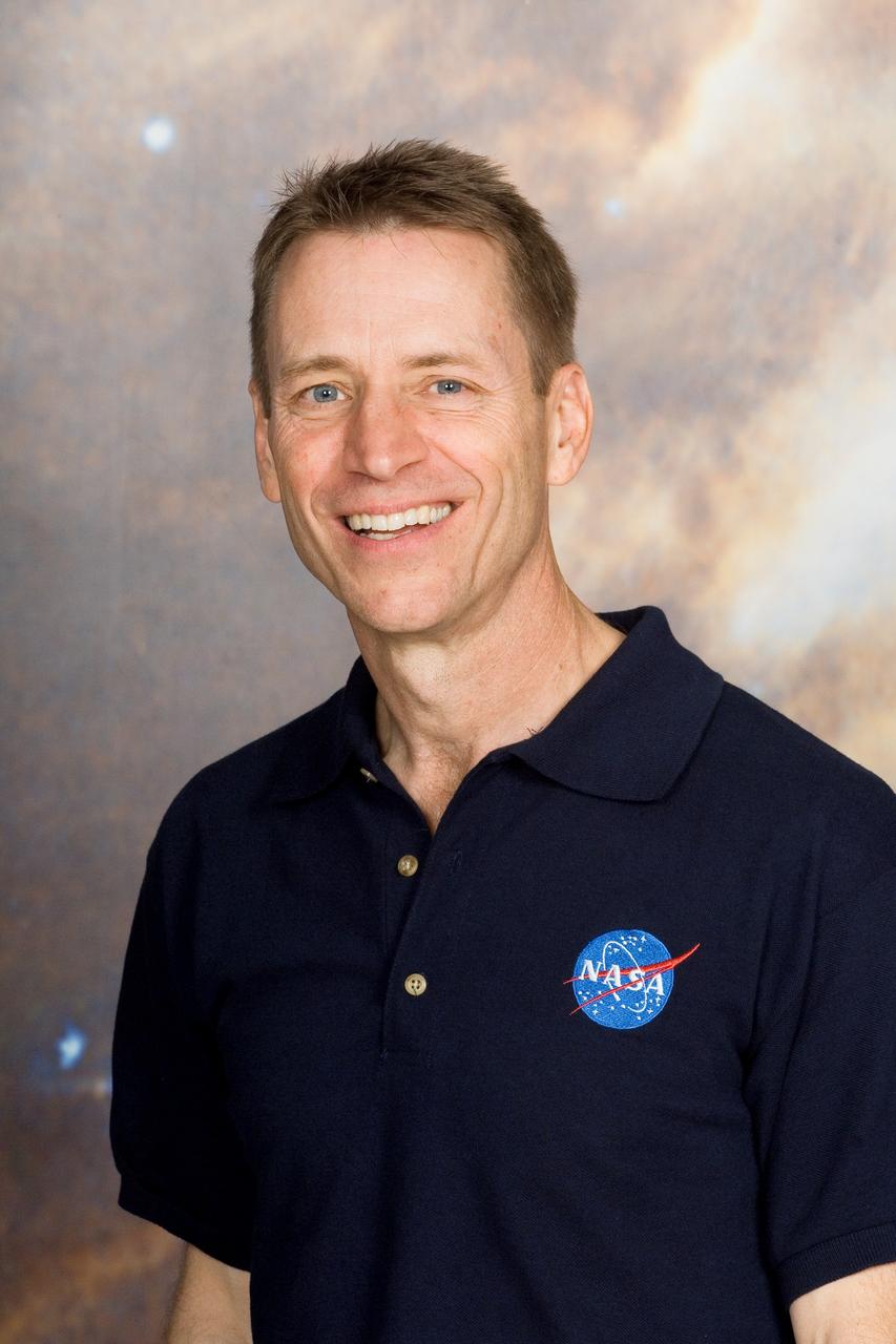
JSC2006-E-47126 (31 Oct. 2006) --- Astronaut Gregory C. Johnson, STS-125 pilot for the newly announced final shuttle crew to visit and work on the Hubble Space Telescope.

S115-E-05942 (13 Sept. 2006) --- Astronaut Daniel C. Burbank, STS-115 mission specialist, participates in the second of three scheduled sessions of extravehicular activity for the shuttle crew.
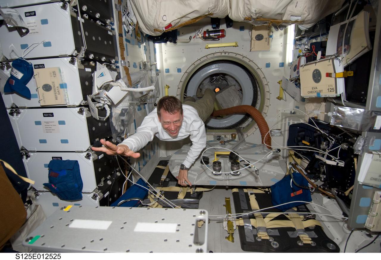
S125-E-012525 (19 May 2009) --- Astronaut Gregory C. Johnson, STS-125 pilot, floats on the middeck of the Earth-orbiting Space Shuttle Atlantis during flight day nine activities.
S125-E-012523 (19 May 2009) --- Astronaut Gregory C. Johnson, STS-125 pilot, floats through a hatch on the middeck of the Earth-orbiting Space Shuttle Atlantis during flight day nine activities.
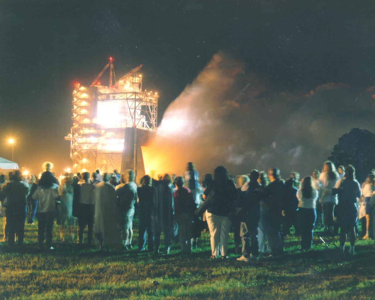
Thousands of people watch the first-ever evening public engine test of a Space Shuttle Main Engine at NASA's John C. Stennis Space Center. The spectacular test marked Stennis Space Center's 20th anniversary celebration of the first Space Shuttle mission.
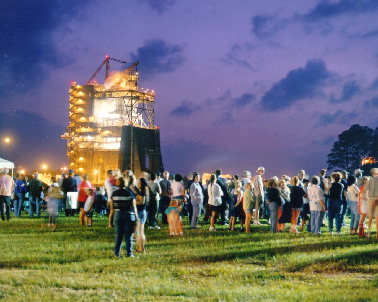
Approximately 13,000 people fill the grounds at NASA's John C. Stennis Space Center for the first-ever evening public engine test of a Space Shuttle Main Engine. The test marked Stennis Space Center's 20th anniversary celebration of the first Space Shuttle mission.

STS049-S-002 (16 Jan. 1992) --- These seven NASA astronauts are currently training for the first flight of the Space Shuttle Endeavour, seen in the background. Daniel C. Brandenstein, center, is mission commander; and Kevin P. Chilton, third from right, is pilot. Mission specialists are, left to right, Kathryn C. Thornton, Bruce E. Melnick, Pierre J. Thout, Thomas D. Akers and Richard J. Hieb.
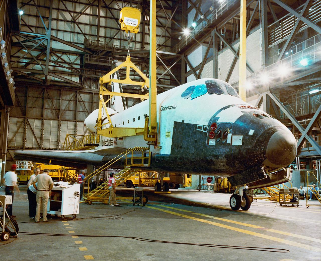
S89-39624 (3 July 1989) --- Following rollover from the Orbiter Processing Facility, the orbiter Columbia is prepared for mating with the ET/SRB stack in the Vehicle Assembly Building transfer aisle as work continues toward an early August launch of Space Shuttle Mission STS-28. STS-28 is a Department of Defense dedicated mission. Crew members for the mission are: Commander Brewster H. Shaw, Pilot Richard N. Richards, and Mission Specialists Mark N. Brown, James C. Adamson, and David C. Leestma.
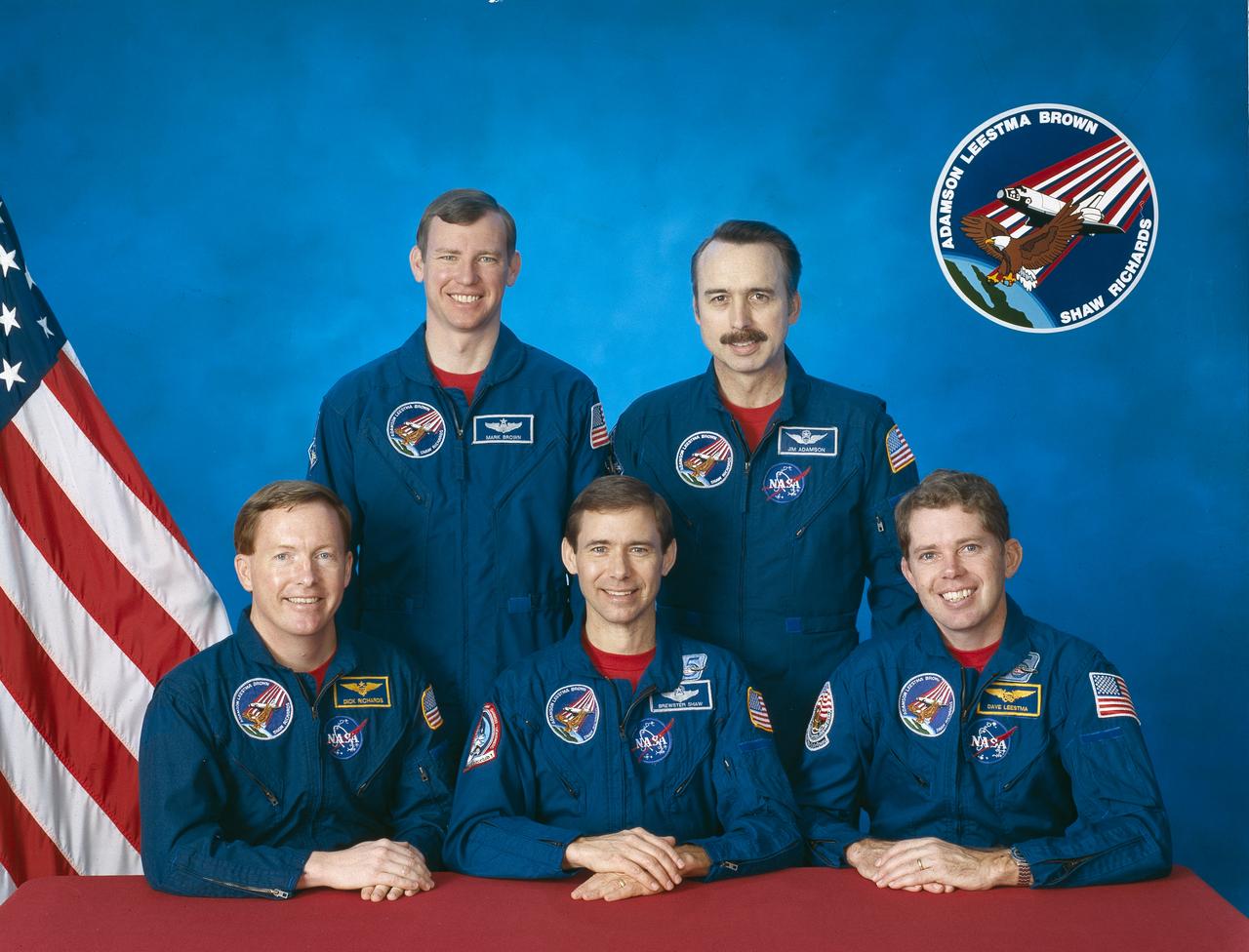
Five astronauts composed the STS-28 crew. Seated from left to right are Richard N. (Dick) Richards, pilot; Brewster H. Shaw, commander; and David C. Leestma, mission specialist 2. Standing, from left to right , are Mark N. Brown, mission specialist 3; and James C. (Jim) Adamson, mission specialist 1. Launched aboard the Space Shuttle Columbia on August 8, 1989, the STS-28 mission was the 4th mission dedicated to the Department of Defense.
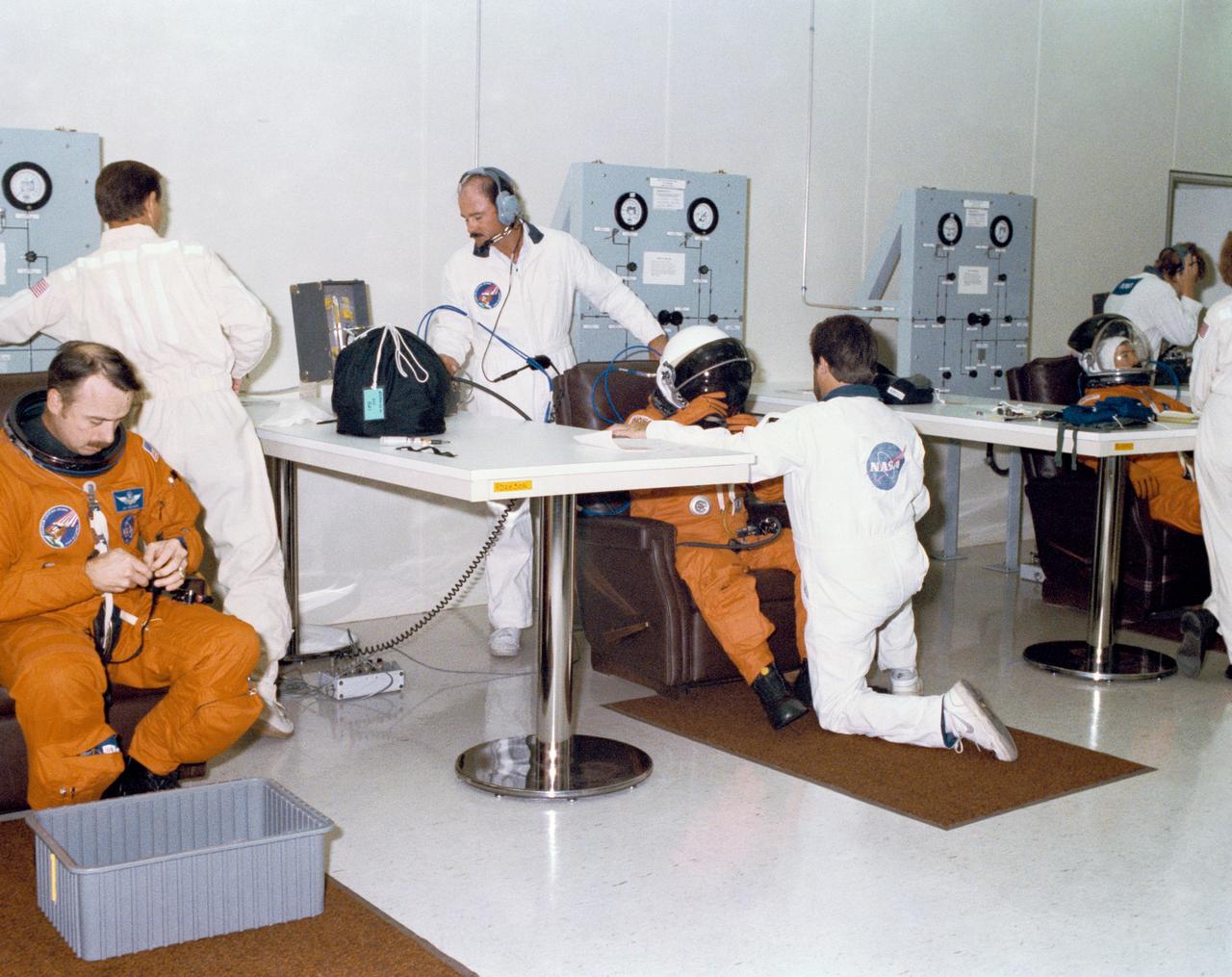
S89-41091 (18 July 1989) --- During the Terminal Countdown Demonstration Test (TCDT), STS-28 crew members are assisted with suiting up in the Operations and Checkout Building prior to departing for pad 39-B. STS-28 and the Space Shuttle Columbia are scheduled to be launched in early August on a Department of Defense dedicated mission. The crew for STS-28 are Commander Brewster H. Shaw; Pilot Richard N. Richards; and Mission Specialists Mark N. Brown, James C. Adamson, and David C. Leestma.
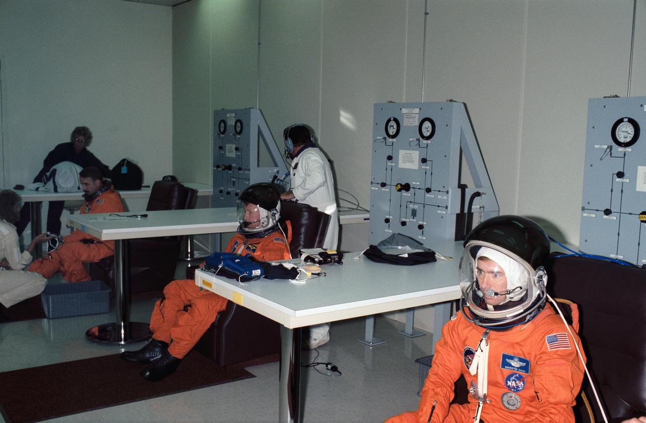
STS028-S-005 (8 Aug 1989) --- Three of five STS-28 astronaut crewmembers are pictured during their suiting up process in preparation for spending several days aboard space shuttle Columbia in earth orbit. Astronaut Brewster H. Shaw Jr., mission commander, is in the foreground. Others pictured in the orange suits used for ascent and entry are Richard N. Richards (center), pilot; and James C. Adamson, one of three mission specialists. Out of the frame are David C. Leestma and Mark N. Brown, mission specialists.
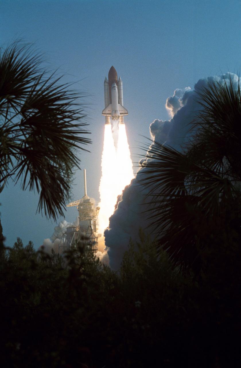
STS028-S-004 (8 Aug. 1989) --- Framed by Florida vegetation, Space Shuttle Columbia soars toward space for the STS-28 mission from Launch Pad 39-B. The spacecraft renews flight after a period of three and a half years, this time with five crewmembers aboard. Onboard the spacecraft are astronauts Brewster H. Shaw Jr., Richard N. Richards, David C. Leestma, James C. Adamson and Mark N. Brown. The last time Columbia was in space was in January of 1986.
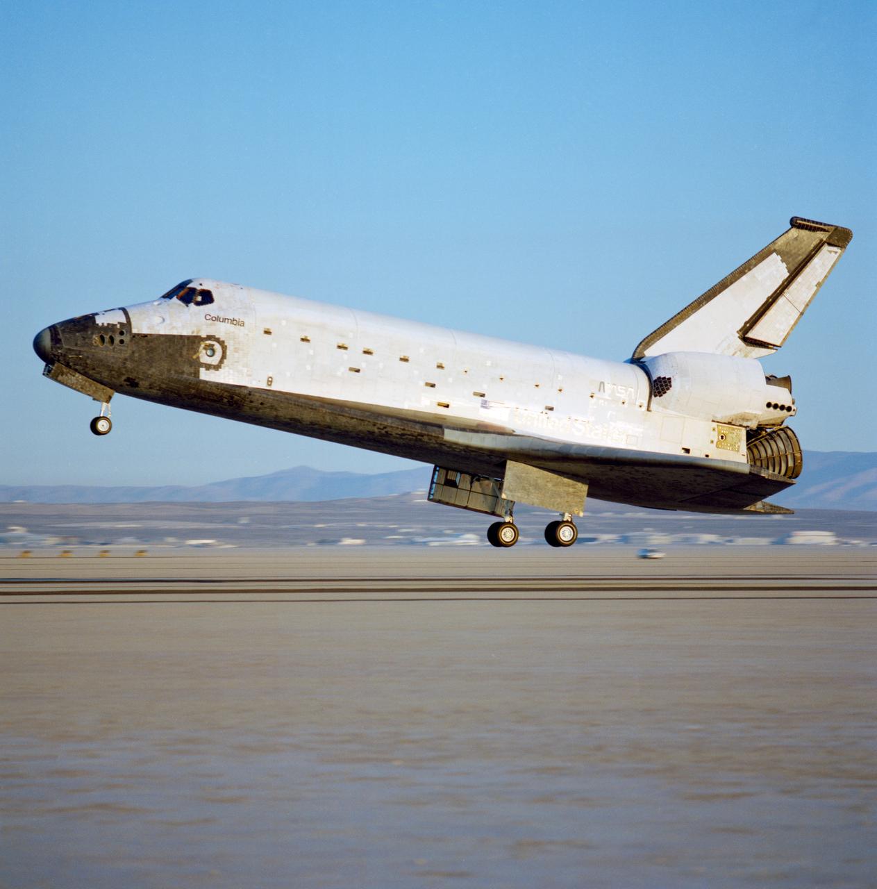
STS028-S-018 (13 Aug 1989) --- The Space shuttle Columbia is captured on film just prior to main gear touchdown at Edwards Air Force Base in Southern California. The landing marked a successful end to a five-day Department of Defense (DOD)-devoted mission. Onboard the spacecraft were astronauts Brewster H. Shaw Jr., Richard N. Richards, David C. Leestma, James C. Adamson and Mark N. Brown.
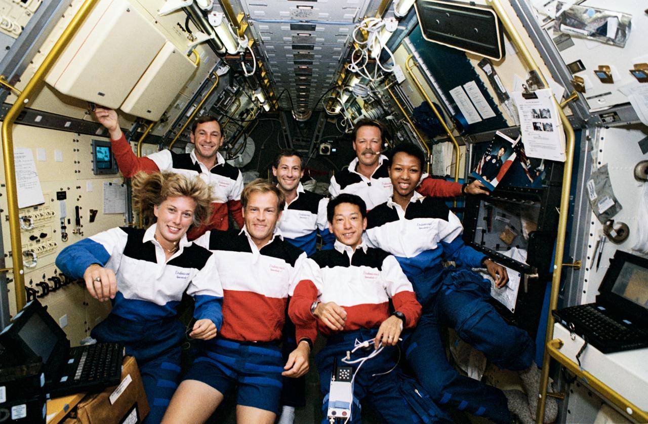
STS047-12-002 (12 - 20 Sept 1992) --- The crew members assemble for their traditional in-flight portrait in this 35mm frame photographed in the Science Module aboard the Earth-orbiting Space Shuttle Endeavour. Left to right (front) are N. Jan Davis, Mark C. Lee and Mamoru Mohri; and (rear) Curtis L. Brown, Jr., Jerome (Jay) Apt, Robert L. Gibson and Mae C. Jemison. The seven spent eight days in space in support of the Spacelab-J mission.
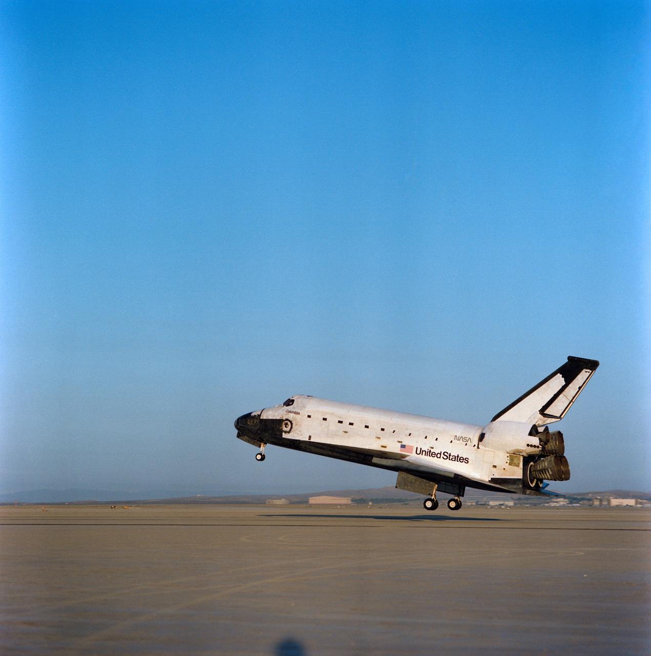
STS028-S-013 (13 Aug 1989) --- The Space Shuttle Columbia is captured on film just prior to main gear touchdown at Edwards Air Force Base in Southern California. The landing marked a successful end to a five-day DOD-devoted mission. Onboard the spacecraft were Astronauts Brewster H. Shaw Jr., Richard N. Richards, David C. Leestma, James C. Adamson and Mark N. Brown.
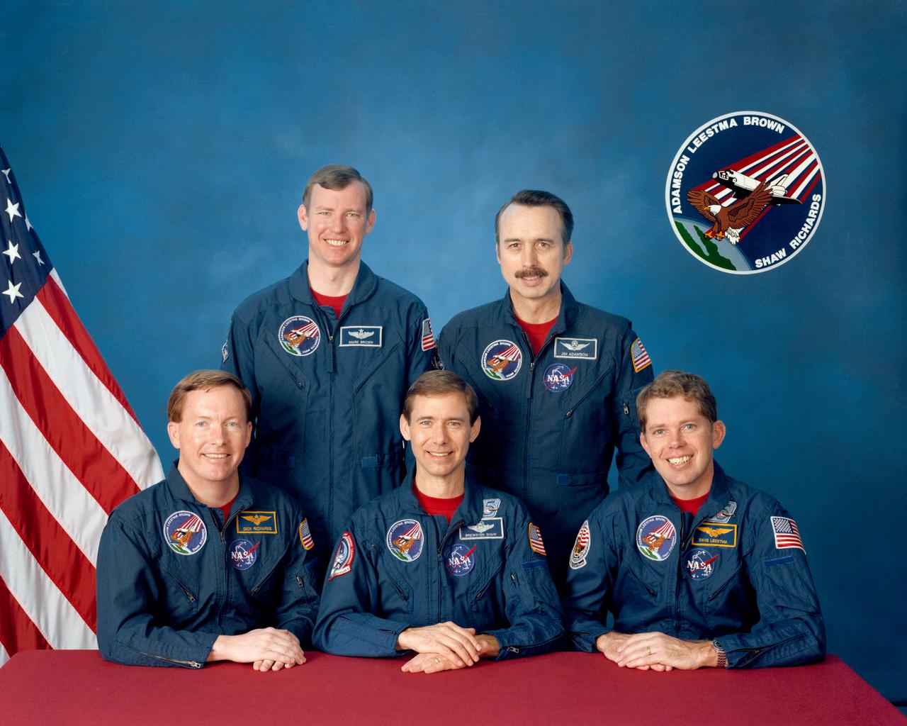
S89-29370 (March 1989) --- These five astronauts have been assigned to man the Space Shuttle Columbia for STS-28, a Department of Defense-devoted mission scheduled for July of this year. Brewster H. Shaw (center, front) is mission commander; and Richard N. Richards (left) is pilot. Mission specialists are, left to right, Mark N. Brown, James C. Adamson and David C. Leestma (seated).
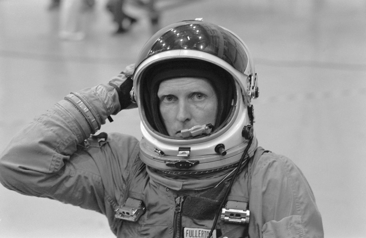
S78-34927 (31 Aug. 1978) --- Astronaut C. Gordon Fullerton, one of a group of eight astronauts named to fly the first few orbital flight tests of the space transportation system, gets ready to participate in a training session for emergency egress from a space shuttle vehicle at the launch pad. He is wearing a USAF modified high altitude pressure garment like those to be worn by shuttle crew members at takeoff and landing. Photo credit: NASA NOTE: Since this photograph was made, astronaut C. Gordon Fullerton was named pilot of STS-3, scheduled for launch in early spring of 1982.
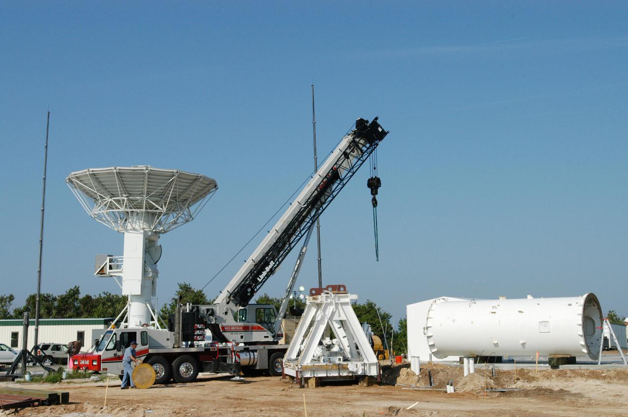
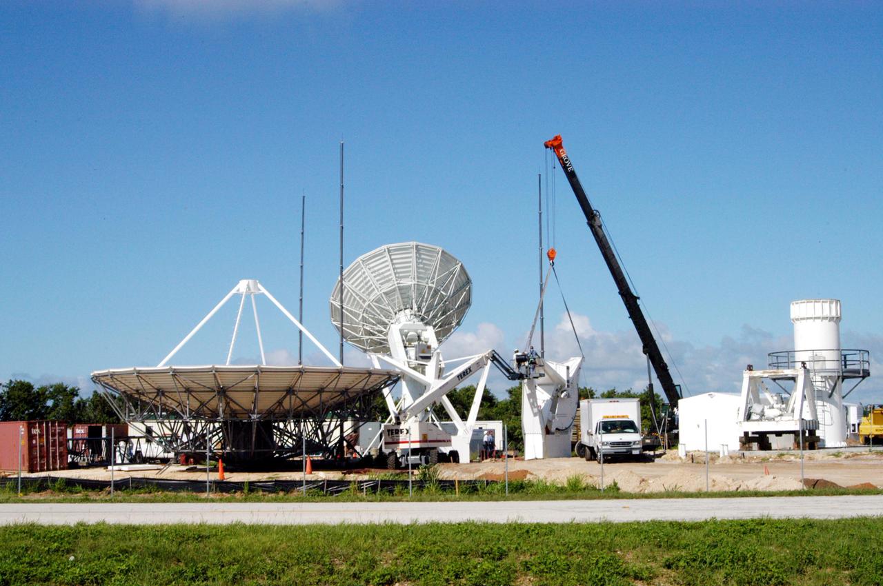
KENNEDY SPACE CENTER, FLA. - At a radar site on North Merritt Island, Fla., north of the Haulover Canal, workers continue assembling a 50-foot C-band radar. The radar will be used for long-term Shuttle missions to track the launches and observe possible debris coming from the Shuttle. In the background is an existing 30-foot C-band Pathfinder radar whose use was demonstrated on the Delta Messenger launch. It will be used on the upcoming two Return to Flight missions. The launch window for the first Return to Flight mission, STS-114, is July 13 to July 31.
KENNEDY SPACE CENTER, FLA. - At a radar site on North Merritt Island, Fla., north of the Haulover Canal, a 50-foot dish for NASA’s C-band radar is being assembled. The radar will be used for long-term Shuttle missions to track the launches and observe possible debris coming from the Shuttle. Behind the dish is an existing 30-foot C-band Pathfinder radar whose use was demonstrated on the Delta Messenger launch. It will be used on the upcoming two Return to Flight missions. The launch window for the first Return to Flight mission, STS-114, is July 13 to July 31.
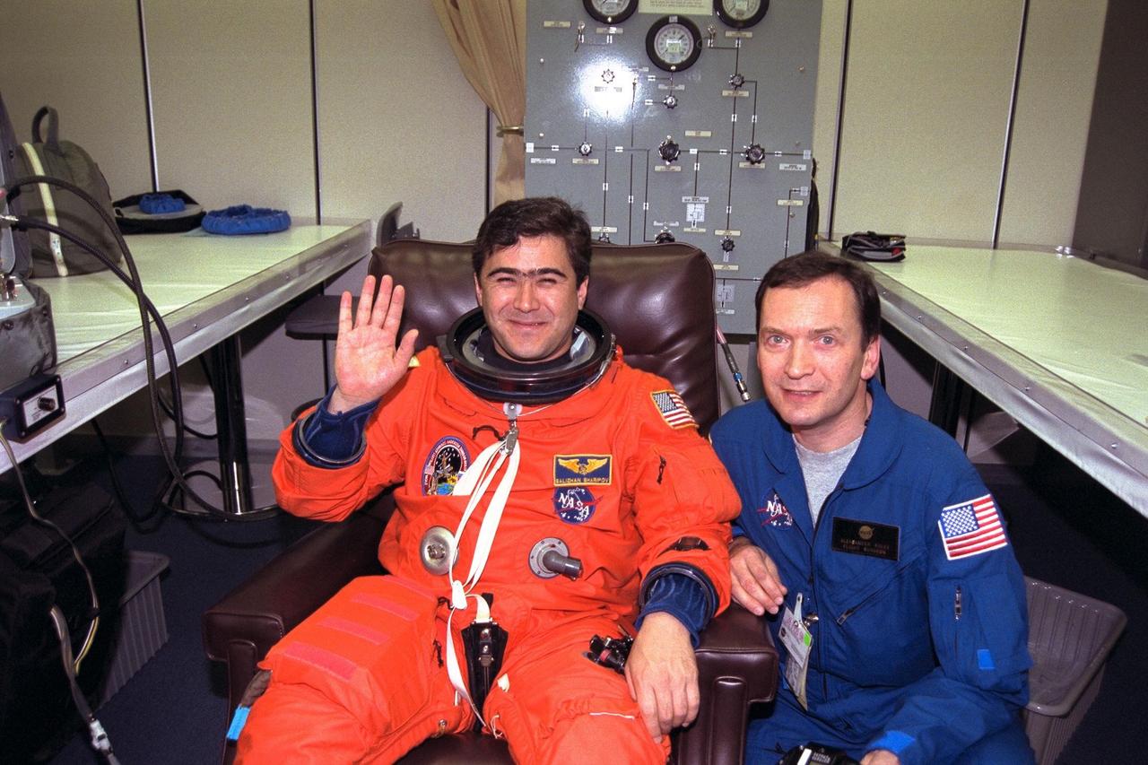
STS-89 Mission Specialist Salizhan Sharipov of the Russian Space Agency, at left, waves as he and his flight surgeon, Alexander Kulev, complete the donning of Sharipov’s launch/entry suit in the Operations and Checkout (O&C) Building. In 1994, Sharipov graduated from Moscow State University with a degree in cartography. He and six fellow crew members will soon depart the O&C and head for Launch Pad 39A, where the Space Shuttle Endeavour will lift off during a launch window that opens at 9:43 p.m. EST, Jan. 22. STS-89 is the eighth of nine planned missions to dock the Space Shuttle with Russia's Mir space station
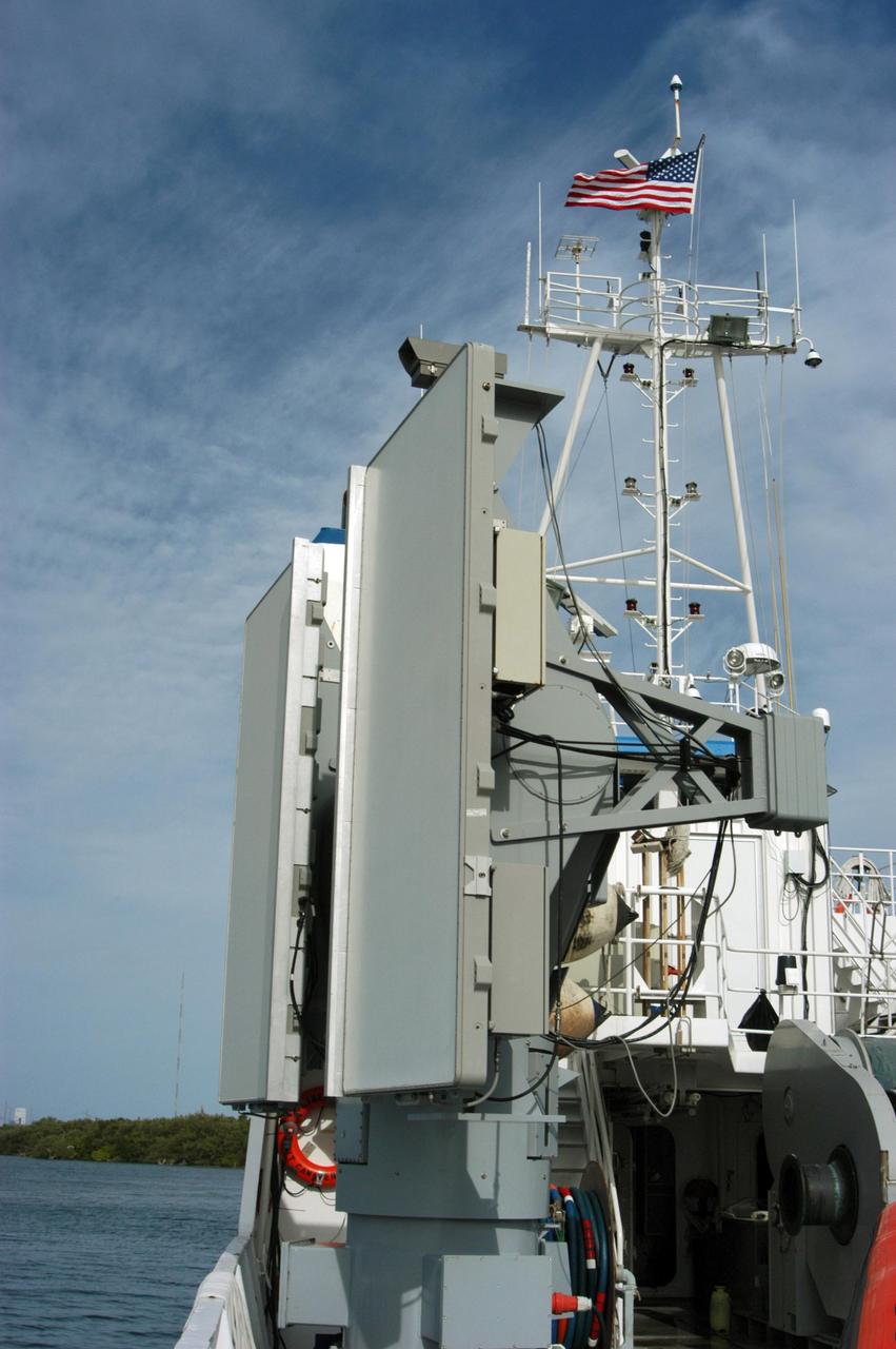
KENNEDY SPACE CENTER, FLA. -- The X-band radar array is installed on the solid rocket booster retrieval ship Liberty before launch of Space Shuttle Discovery. It is one of two Weibel Continuous Pulse Doppler X-band radars located on each of the two SRB retrieval ships. This one will be located downrange of the launch site. Working with the land-based C-band radar, the X-band radars provide velocity and differential shuttle/debris motion information during launch. The radar data will be sent from the ships via satellite link and analyzed at the C-band radar site located on north Kennedy Space Center. Photo credit: NASA/George Shelton