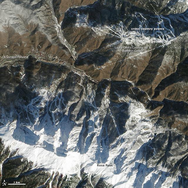
High res here: <a href="http://www.flickr.com/photos/gsfc/12640339235/in/photostream/">www.flickr.com/photos/gsfc/12640339235/in/photostream/</a> While Sochi is a coastal town on the Black Sea, the skiing events for the XXII Olympic Games are taking place about 40 kilometers (25 miles) inland. The venues are clustered around Krasnaya Polyana, a small town tucked between the Aibiga and Psekhako Ridges in the western Caucasus. This image—acquired by the Advanced Land Imager (ALI) on NASA’s Earth Observing-1 (EO-1) satellite on February 8, 2014—offers a view of the town and the ski facilities. The Rosa Khutor Alpine Center is the home to the downhill, snowboard, and freestyle events. The combined downhill skiing area measures about 20 kilometers (12 miles) in total, with the men’s downhill course stretching 3,500 meters (11,482 feet) and featuring a 1,075-meter (3,526 foot) change in elevation. The highest lift climbs to the summit of Rosa Peak, which rises 2,320 meters (7,612 feet). While not being used for the Olympics, the nearby Black Pyramid mountain has downhill skiing trails as well. The same steep slopes that make Rosa Peak good for skiing also elevate the risk of avalanches. To protect against falling snow, planners installed a series of gas pipes along the top of the ridge. The pipes emit bursts of oxygen and propane that create small, controlled avalanches. Event organizers also installed a series of earthen dams to steer snow away from infrastructure, and they have deployed two backhoes to the top of Aibiga Ridge to knock cornices away before they pose a risk. The Laura Cross-country Ski and Biathalon Center is located to the north on Psekhako Ridge. It includes two stadiums, each with their own start and finish zones, two track systems for skiing and biathlon, as well as shooting areas and warm-up zones. The center is named for the Laura River, a turbulent river that flows nearby. NASA Earth Observatory image by Jesse Allen and Robert Simmon, using EO-1 ALI data provided courtesy of the NASA EO-1 team. Caption by Adam Voiland. Instrument: EO-1 - ALI Read more: <a href="http://earthobservatory.nasa.gov/IOTD/view.php?id=83131&eocn=home&eoci=iotd_grid" rel="nofollow">earthobservatory.nasa.gov/IOTD/view.php?id=83131&eocn...</a> Credit: <b><a href="http://www.earthobservatory.nasa.gov/" rel="nofollow"> NASA Earth Observatory</a></b> <b><a href="http://www.nasa.gov/audience/formedia/features/MP_Photo_Guidelines.html" rel="nofollow">NASA image use policy.</a></b> <b><a href="http://www.nasa.gov/centers/goddard/home/index.html" rel="nofollow">NASA Goddard Space Flight Center</a></b> enables NASA’s mission through four scientific endeavors: Earth Science, Heliophysics, Solar System Exploration, and Astrophysics. Goddard plays a leading role in NASA’s accomplishments by contributing compelling scientific knowledge to advance the Agency’s mission. <b>Follow us on <a href="http://twitter.com/NASAGoddardPix" rel="nofollow">Twitter</a></b> <b>Like us on <a href="http://www.facebook.com/pages/Greenbelt-MD/NASA-Goddard/395013845897?ref=tsd" rel="nofollow">Facebook</a></b> <b>Find us on <a href="http://instagram.com/nasagoddard?vm=grid" rel="nofollow">Instagram</a></b>
While Sochi is a coastal town on the Black Sea, the skiing events for the XXII Olympic Games are taking place about 40 kilometers (25 miles) inland. The venues are clustered around Krasnaya Polyana, a small town tucked between the Aibiga and Psekhako Ridges in the western Caucasus. This image—acquired by the Advanced Land Imager (ALI) on NASA’s Earth Observing-1 (EO-1) satellite on February 8, 2014—offers a view of the town and the ski facilities. The Rosa Khutor Alpine Center is the home to the downhill, snowboard, and freestyle events. The combined downhill skiing area measures about 20 kilometers (12 miles) in total, with the men’s downhill course stretching 3,500 meters (11,482 feet) and featuring a 1,075-meter (3,526 foot) change in elevation. The highest lift climbs to the summit of Rosa Peak, which rises 2,320 meters (7,612 feet). While not being used for the Olympics, the nearby Black Pyramid mountain has downhill skiing trails as well. The same steep slopes that make Rosa Peak good for skiing also elevate the risk of avalanches. To protect against falling snow, planners installed a series of gas pipes along the top of the ridge. The pipes emit bursts of oxygen and propane that create small, controlled avalanches. Event organizers also installed a series of earthen dams to steer snow away from infrastructure, and they have deployed two backhoes to the top of Aibiga Ridge to knock cornices away before they pose a risk. The Laura Cross-country Ski and Biathalon Center is located to the north on Psekhako Ridge. It includes two stadiums, each with their own start and finish zones, two track systems for skiing and biathlon, as well as shooting areas and warm-up zones. The center is named for the Laura River, a turbulent river that flows nearby. NASA Earth Observatory image by Jesse Allen and Robert Simmon, using EO-1 ALI data provided courtesy of the NASA EO-1 team. Caption by Adam Voiland. Instrument: EO-1 - ALI Read more: <a href="http://earthobservatory.nasa.gov/IOTD/view.php?id=83131&eocn=home&eoci=iotd_grid" rel="nofollow">earthobservatory.nasa.gov/IOTD/view.php?id=83131&eocn...</a> Credit: <b><a href="http://www.earthobservatory.nasa.gov/" rel="nofollow"> NASA Earth Observatory</a></b> <b><a href="http://www.nasa.gov/audience/formedia/features/MP_Photo_Guidelines.html" rel="nofollow">NASA image use policy.</a></b> <b><a href="http://www.nasa.gov/centers/goddard/home/index.html" rel="nofollow">NASA Goddard Space Flight Center</a></b> enables NASA’s mission through four scientific endeavors: Earth Science, Heliophysics, Solar System Exploration, and Astrophysics. Goddard plays a leading role in NASA’s accomplishments by contributing compelling scientific knowledge to advance the Agency’s mission. <b>Follow us on <a href="http://twitter.com/NASAGoddardPix" rel="nofollow">Twitter</a></b> <b>Like us on <a href="http://www.facebook.com/pages/Greenbelt-MD/NASA-Goddard/395013845897?ref=tsd" rel="nofollow">Facebook</a></b> <b>Find us on <a href="http://instagram.com/nasagoddard?vm=grid" rel="nofollow">Instagram</a></b>
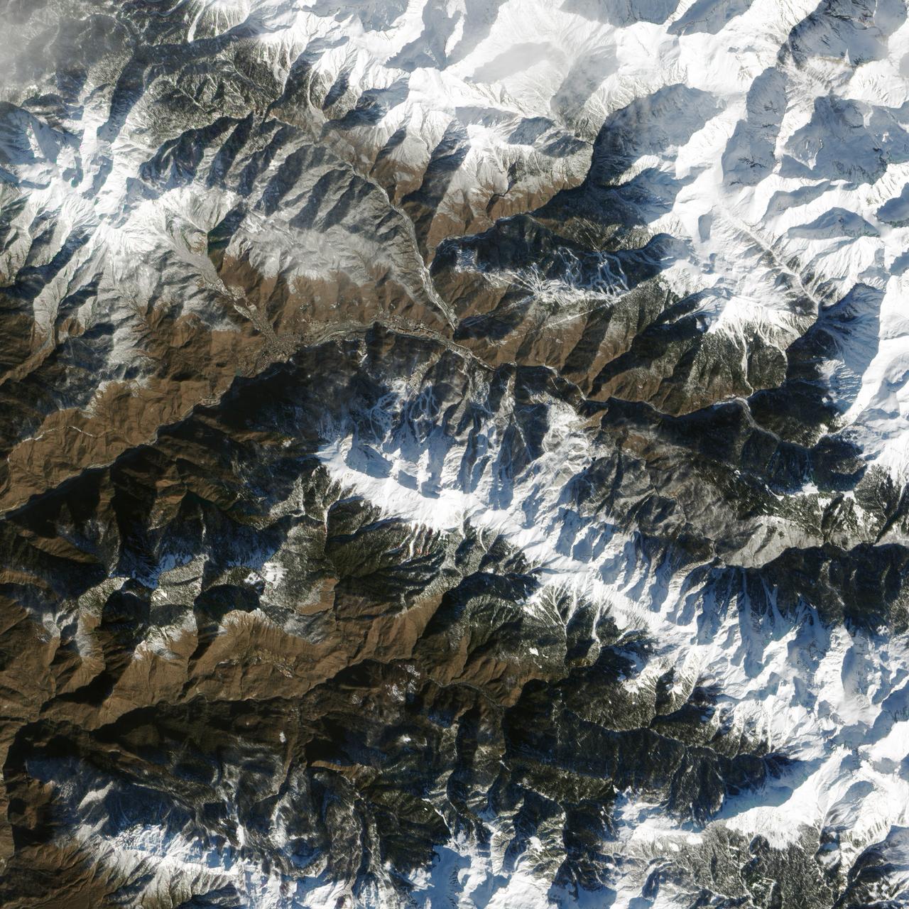
The 2014 Winter Olympic ski runs may be rated double black diamond, but theyre not quite as steep as they appear in this image acquired by NASA Terra spacecraft, of the skiing and snowboarding sites for the Sochi Winter Olympic Games.

Sochi, Russia Winter Olympic Sites (Mountain Cluster) The 2014 Winter Olympic ski runs may be rated double black diamond, but they're not quite as steep as they appear in this image of the skiing and snowboarding sites for the Sochi Winter Olympic Games, acquired on Jan. 4, 2014, by the Advanced Spaceborne Thermal Emission and Reflection Radiometer (ASTER) instrument on NASA's Terra spacecraft. Rosa Khutar ski resort near Sochi, Russia, is in the valley at center, and the runs are visible on the shadowed slopes on the left-hand side of the valley. Height has been exaggerated 1.5 times to bring out topographic details. The games, which begin on Feb. 7 and continue for 17 days, feature six new skiing and boarding events plus the return of the legendary Jamaican bobsled team to the winter games for the first time since 2002. In this southwest-looking image, red indicates vegetation, white is snow, and the resort site appears in gray. The area imaged is about 11 miles (18 kilometers) across in the foreground and 20 miles (32 kilometers) from front to back. The image was created from the ASTER visible and near-infrared bands, draped over ASTER-derived digital elevation data. With its 14 spectral bands from the visible to the thermal infrared wavelength region and its high spatial resolution of 15 to 90 meters (about 50 to 300 feet), ASTER images Earth to map and monitor the changing surface of our planet. ASTER is one of five Earth-observing instruments launched Dec. 18, 1999, on Terra. The instrument was built by Japan's Ministry of Economy, Trade and Industry. A joint U.S./Japan science team is responsible for validation and calibration of the instrument and data products. The broad spectral coverage and high spectral resolution of ASTER provides scientists in numerous disciplines with critical information for surface mapping and monitoring of dynamic conditions and temporal change. Example applications are: monitoring glacial advances and retreats; monitoring potentially active volcanoes; identifying crop stress; determining cloud morphology and physical properties; wetlands evaluation; thermal pollution monitoring; coral reef degradation; surface temperature mapping of soils and geology; and measuring surface heat balance. The U.S. science team is located at NASA's Jet Propulsion Laboratory, Pasadena, Calif. The Terra mission is part of NASA's Science Mission Directorate, Washington, D.C. More information about ASTER is available at <a href="http://asterweb.jpl.nasa.gov/" rel="nofollow">asterweb.jpl.nasa.gov/</a>. credit:NASA/GSFC/METI/ERSDAC/JAROS, and U.S./Japan ASTER Science Team <b><a href="http://www.nasa.gov/audience/formedia/features/MP_Photo_Guidelines.html" rel="nofollow">NASA image use policy.</a></b> <b><a href="http://www.nasa.gov/centers/goddard/home/index.html" rel="nofollow">NASA Goddard Space Flight Center</a></b> enables NASA’s mission through four scientific endeavors: Earth Science, Heliophysics, Solar System Exploration, and Astrophysics. Goddard plays a leading role in NASA’s accomplishments by contributing compelling scientific knowledge to advance the Agency’s mission. <b>Follow us on <a href="http://twitter.com/NASAGoddardPix" rel="nofollow">Twitter</a></b> <b>Like us on <a href="http://www.facebook.com/pages/Greenbelt-MD/NASA-Goddard/395013845897?ref=tsd" rel="nofollow">Facebook</a></b> <b>Find us on <a href="http://instagram.com/nasagoddard?vm=grid" rel="nofollow">Instagram</a></b>