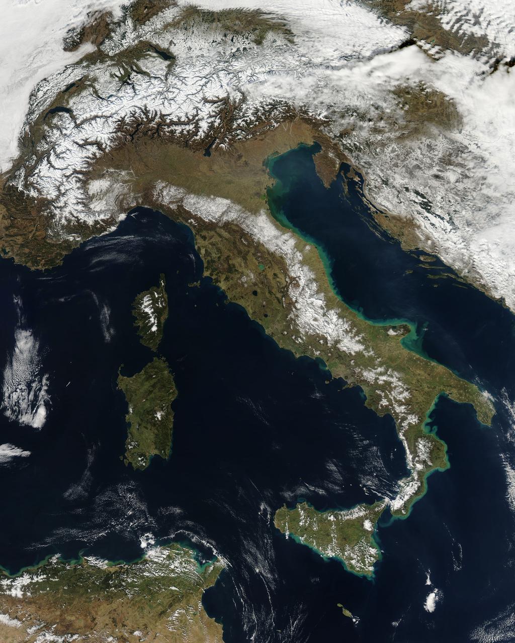
NASA image acquired February 24, 2012 By late February, 2012, the great European cold wave had begun to loosen its frigid grip, but significant snow still remained in the region. The Moderate Resolution Imaging Spectroradiometer (MODIS) aboard the Aqua satellite captured this true-color image of snow in Italy on February 24 at 12:35 UTC (1:30 p.m. local time). In the north of the image, bright white clouds blanket the region in a broad arc. Snow, which tends to be generally less bright that clouds, covers the Alps in the north of Italy. The Apennine Mountains, which form the backbone of the Italian peninsula, also carry a blanket of snow. Although clouds and snow can, at times, be distinguished visually in a true-color image, sometimes they can appear very similar. When it is important to clearly define snow from cloud, false color images are often helpful. Rome, which can be seen as a gray smudge on the southwestern coast of the peninsula, recorded highs of a spring-like 50°F the day this image was captured, but earlier in the month the temperatures dove as low as 26°F on February 5. During that cold snap a rare intense snowfall blanketed Rome, causing the closure of the Colosseum, the Roman Forum and the Palatine Hill due to concerns of the risk of icy footing for tourists, and roads became impassible. Further north, temperatures plummeted to −21 °C (−6 °F) on 7 February. On February 11, news media reported over 2 meters (6.5 feet) of snow had fallen in Urbino, a walled town situated on a high sloping hillside on the eastern side of the Apennine Mountains. That same snowfall cut access to many remote towns in the Apennines, blocking roads and trapping some people in the homes. Credit: NASA/GSFC/Jeff Schmaltz/MODIS Land Rapid Response Team <b><a href="http://www.nasa.gov/centers/goddard/home/index.html" rel="nofollow">NASA Goddard Space Flight Center</a></b> enables NASA’s mission through four scientific endeavors: Earth Science, Heliophysics, Solar System Exploration, and Astrophysics. Goddard plays a leading role in NASA’s accomplishments by contributing compelling scientific knowledge to advance the Agency’s mission. <b>Follow us on <a href="http://twitter.com/NASA_GoddardPix" rel="nofollow">Twitter</a></b> <b>Like us on <a href="http://www.facebook.com/pages/Greenbelt-MD/NASA-Goddard/395013845897?ref=tsd" rel="nofollow">Facebook</a></b> <b>Find us on <a href="http://instagrid.me/nasagoddard/?vm=grid" rel="nofollow">Instagram</a></b>
This image from NASA KidSat spans the region of Venetia from the city of Venice, Italy, on the coast of the Adriatic Sea north to the snow-capped Alps. Venice appears in the lower left part of the image, and the Alps appear in the lower right.
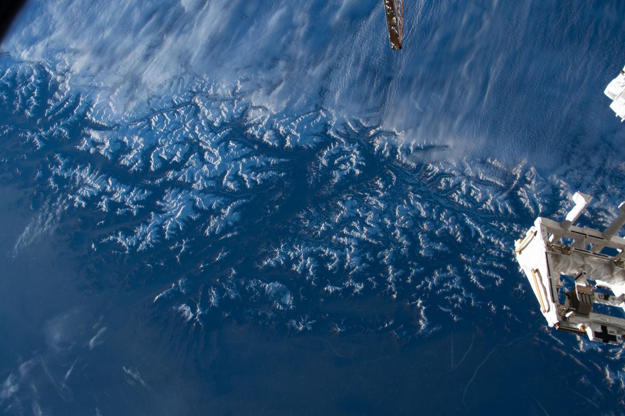
iss070e080294 (Jan. 23, 2024) --- Clouds stop on the peaks of the snow-capped Alps that separate Italy's Po Valley from Austria in this photograph from the International Space Station as it orbited 261 miles above.
SL3-121-2438 (July-September 1973) --- The Alps of Switzerland, France and Italy are featured in this exceptional photograph taken by a hand-held camera from the Skylab space station during the second manned Skylab mission. Also visible in the out-the-window 70mm Hasselblad view are Lake Geneva, Lake of Lucerne, Rhone River and many other features. The Skylab 3 crewmen, astronauts Alan L. Bean, Owen K. Garriott and Jack R. Lousma completed a 59-day mission with a successful splashdown on Sept. 25, 1973. Photo credit: NASA
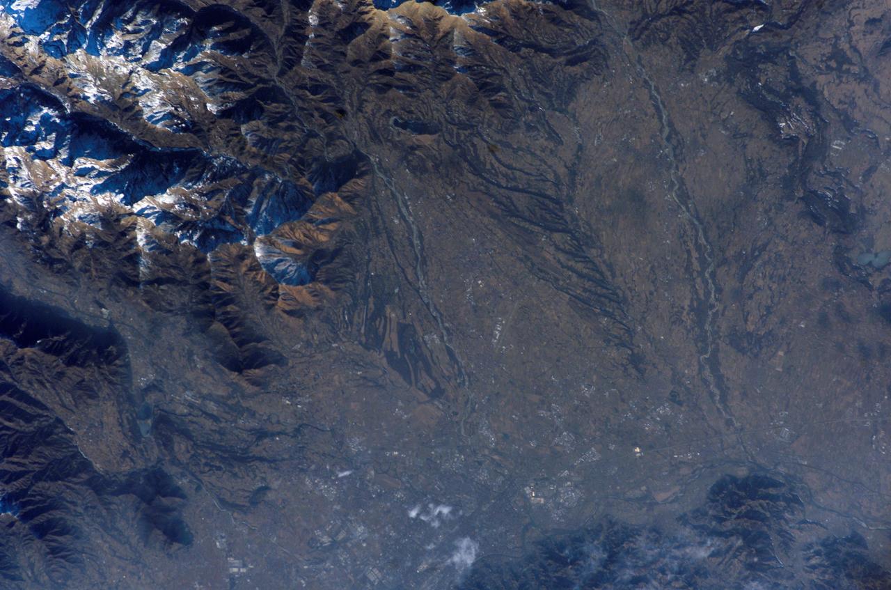
ISS012-E-15598 (21 Jan. 2006) --- PLEASE ORIENT PHOTO WITH SNOW-COVERED MOUNTAINS AT LOWER RIGHT CORNER. NORTH WILL THEN BE TOWARD BOTTOM. Turin (Torino), Italy is featured in this image photographed by an Expedition 12 crewmember on the International Space Station (ISS). Located in the Piemonte region of northwestern Italy, Torino is host of the Twentieth Olympic Winter Games. Venues for the Games include several locations within downtown Torino and the nearby Alps to the west. In this image, the built area of Turin appears dark grayish brown with large building complexes indicated by white roofs (above center of frame). Also shown are the snow-capped Alps visible to the west and north and two tributaries of the Po River, Stura di Lanzo and the Malone River.
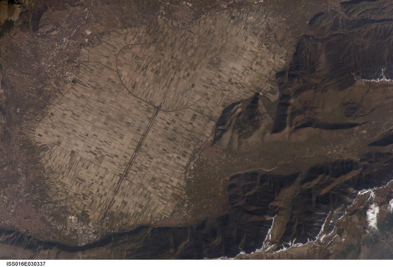
ISS016-E-030337 (26 Feb. 2008) --- Fucine Lake, central Italy is featured in this image photographed by an Expedition 16 crewmember on the International Space Station. The light tan oval in this image is the floor of a lake in central Italy that has been drained by a tunnel dug through the surrounding hills. Numerous rectangular fields can be seen on this former lake bottom--now one of the most fertile regions of Italy. The existence of a former lake explains the name of the area. The town of Avezzano (bottom left), near the drainage outlet of the basin, lies 80 kilometers east of Rome. The "circumference road" can be detected tracking around the edge of the lake; it roughly follows the boundary between green, vegetated fields around the basin and tan fallow fields within. This recent photograph shows a dusting of snow along mountain ridges to the south (image upper and lower right). The basin of Fucine Lake has no natural outlet. Consequently the level of the original lake fluctuated widely with any higher-than-average rainfall.
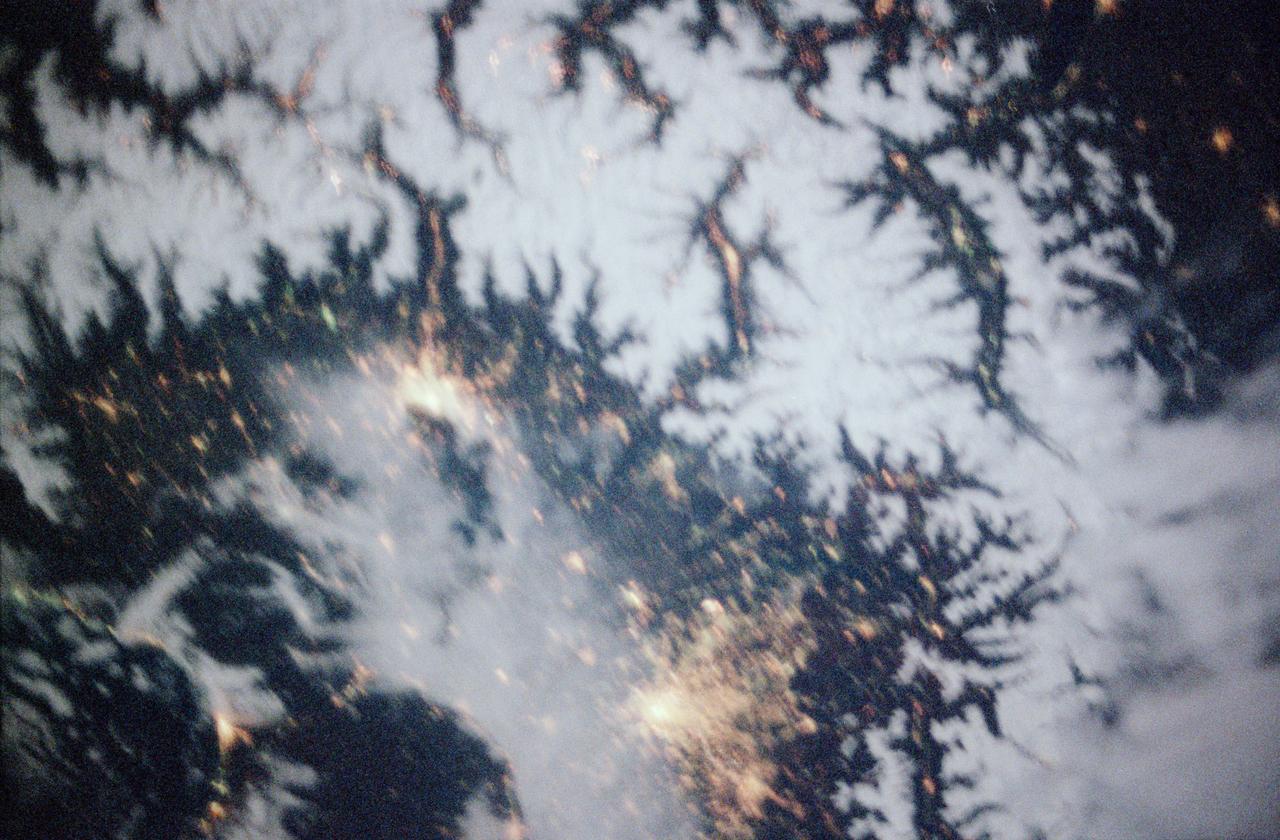
STS097-355-011 (30 Nov. -11 Dec. 2000) --- This vertical scene showing Torino and Milano, Italy, at night, was photographed with a 35mm camera by one of the STS-97 crew members aboard the Earth-orbiting Space Shuttle Endeavour. The night lights of Torino and Milano (two larger illuminated areas) are visible in the view, which covers the western end of the Po River Valley. Torino is the bright spot slightly left of center and Milano is the larger bright spot towards the bottom center of the image. The deeply eroded flanks of the snow-covered Alps Mountains (serrated-looking, light-colored terrain top half of the image) is visible north of the two large cities. Several mountain passes that connect the Po River Valley with France and Switzerland can be identified by the string of lights in the narrow, linear valleys. A translucent-looking cloud (bottom center) somewhat obscures the nighttime landscape south of Torino and Milano. The northwest coast of Italy, including the Italian city of Genova, can be identified in the lower left corner of the image. This photography was taken by astronauts using high speed film and long exposure on a night with a full moon illuminating the surface of the Earth.
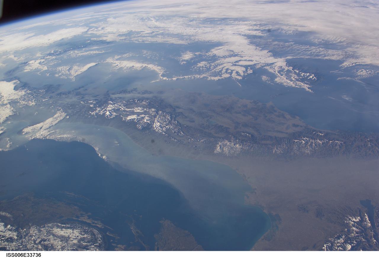
ISS006-E-33736 (25 February 2003) --- The boot of Italy crosses the image in this southwest-looking view taken by an Expedition Six crewmember onboard the International Space Station (ISS). The spine of Italy is highlighted with snow and the largely cloud-covered Mediterranean Sea is at the top. The Adriatic Sea transverses most of the bottom of the image and Sicily appears top left beyond the toe of the boot. The heel lies out of the left side of the image. Corsica and Sardinia appear right of center partly under cloud. The floor of the Po River valley, lower right, is obscured by haze. Experience gained from similar haze events, in which atmospheric pressure, humidity and visibility and atmospheric chemistry were known, suggests that the haze as industrial smog. Industrial haze from the urban region of the central and upper Po valley accumulates to visible concentrations under conditions of high atmospheric pressure and the surrounding mountains prevent easy dispersal. This view illustrates the markedly different color and texture of cloud versus industrial aerosol haze.
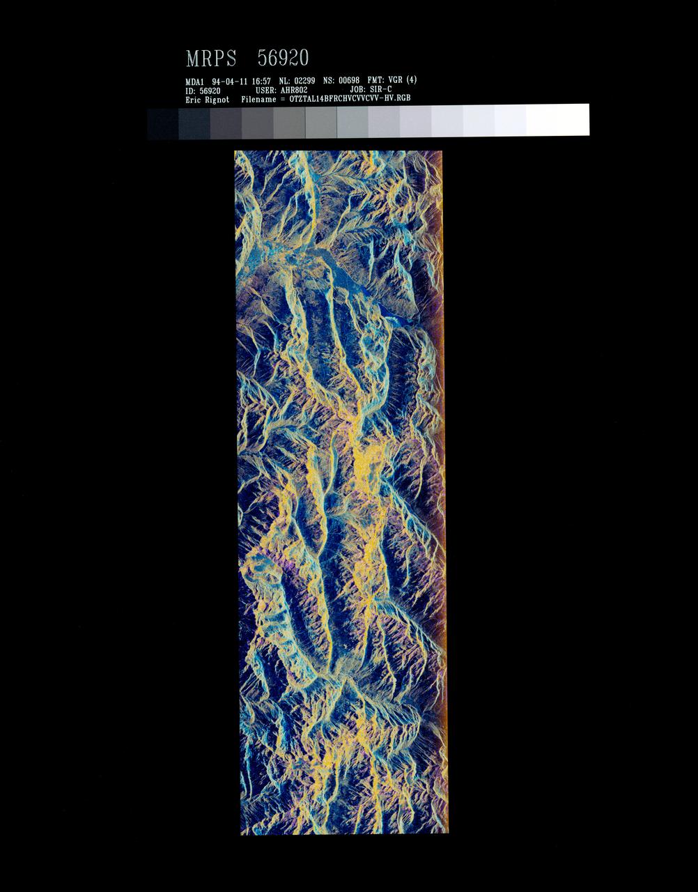
STS059-S-072 (13 April 1994) --- This image is a false-color composite of Oetztal, Austria located in the Central Alps, centered at 46.8 degrees north latitude, and 10.70 degrees east longitude, at the border between Switzerland (top), Italy (left) and Austria (right and bottom). The area shown is 50 kilometers (30 miles) south of Innsbruck, Austria. This image was acquired by the Spaceborne Imaging Radar-C and X-Band Synthetic Aperture Radar (SIR-C/X-SAR) aboard the Space Shuttle Endeavour on its 14th orbit. Oetztal is a SIR-C/X-SAR hydrology supersite. Approximately one quarter of this image is covered by glaciers, the largest of which, Gepatschferner, is visible as a triangular yellow patch in the center of the scene. The summits of the main peaks reach elevations between 3,500 and 3,768 meters (11,500 and 12,362 feet) above sea level. The tongues of the glaciers are descending from elevated plateaus down into narrow valleys which were formed during the last ice age. This color image was produced in C-Band using multi-polarization information (Red=CHV, Green=CVV, Blue=CVV/CHV). The blue areas are lakes (Gepatsch Dam at center right; Lake Muta at top right) and glacier ice. The yellow areas are slopes facing the radar and areas of dry snow. Purple corresponds to slopes facing away from the radar. Yellow in the valley bottom corresponds to tree covered areas. There is 30 to 50 centimeters (12 to 20 inches) of dry, fresh snow on the glaciers, and about 10 centimeters (4 inches) in the valley at the city of Vent, Austria (center). At these data were taken, the weather was cold, with snow and thick fog. The entire area would appear white to an optical sensor because it is all covered under a winter snowpack. Researchers are interested in Oetztal because knowing how glaciers shrink and grow over time is an important indication of climatic change. SIR-C/X-SAR is part of NASA's Mission to Planet Earth (MTPE). SIR-C/X-SAR radars illuminate Earth with microwaves allowing detailed observations at any time, regardless of weather or sunlight conditions. SIR-C/X-SAR uses three microwave wavelengths: L-Band (24 cm), C-Band (6 cm), and X-Band (3 cm). The multi-frequency data will be used by the international scientific community to better understand the global environment and how it is changing. The SIR-C/X-SAR data, complemented by aircraft and ground studies, will give scientists clearer insights into those environmental changes which are caused by nature and those changes which are induced by human activity. SIR-C was developed by NASA's Jet Propulsion Laboratory (JPL). X-SAR was developed by the Dornire and Alenia Spazio Companies for the German Space Agency, Deutsche Agentur fuer Raumfahrtangelegenheiten (DARA), and the Italian Space Agency, Agenzia Spaziale Italiana (ASI). JPL Photo ID: P-43890