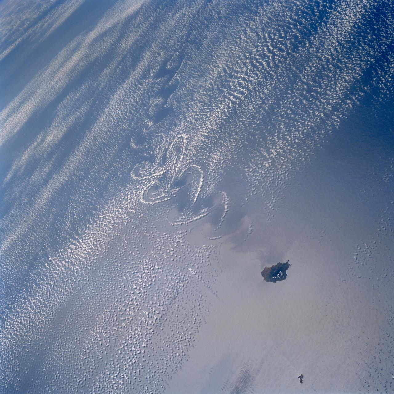
STS099-703-007 (11-22 February 2000) ---A distinct cumulus cloud pattern marks the island wake within a weak northerly wind field in the vicinity of Isla Socorro, south of the Baja Peninsula of Mexico. The photo was taken by one of the astronauts aboard the Space Shuttle Endeavour as it orbited Earth in February 2000. A smaller companion island, San Benedicto, is visible to the north-northeast. Socorro rises to just over 3,400 feet and disrupts the winds which apparently are not strong or persistent enough to form closed vortices.
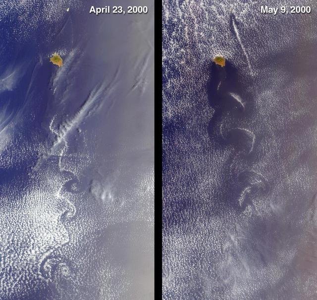
Socorro, Mexico was captured by NASA Terra satellite in 2000 showing cloud swirls, like delicate lace, forming patterns known as von Karman vortex streets.
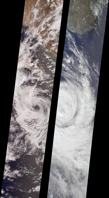
Like dancers pirouetting in opposite directions, the rotational patterns of two different tropical storms are contrasted in this pair of MISR nadir-camera images. The left-hand image is of Tropical Storm Bud, acquired on June 17, 2000 (Terra orbit 2656) as the storm was dissipating. Bud was situated in the eastern Pacific Ocean between Socorro Island and the southern tip of Baja California. South of the storm's center is a vortex pattern caused by obstruction of the prevailing flow by tiny Socorro Island. Sonora, Mexico and Baja California are visible at the top of the image. The right-hand image is of Tropical Cyclone Dera, acquired on March 12, 2001 (Terra orbit 6552). Dera was located in the Indian Ocean, south of Madagascar. The southern end of this large island is visible in the top portion of this image. Northern hemisphere tropical storms, like Bud, rotate in a counterclockwise direction, whereas those in the southern hemisphere, such as Dera, rotate clockwise. The opposite spins are a consequence of Earth's rotation. Each image covers a swath approximately 380 kilometers wide. http://photojournal.jpl.nasa.gov/catalog/PIA03400
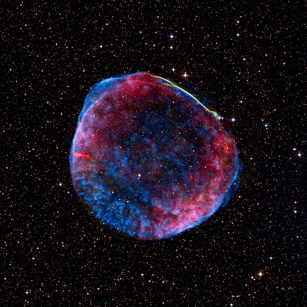
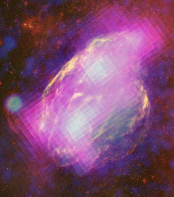
Release date: July 1, 2008 This image is a composite of visible (or optical), radio, and X-ray data of the full shell of the supernova remnant from SN 1006. The radio data show much of the extent that the X-ray image shows. In contrast, only a small linear filament in the northwest corner of the shell is visible in the optical data. The object has an angular size of roughly 30 arcminutes (0.5 degree, or about the size of the full moon), and a physical size of 60 light-years (18 parsecs) based on its distance of nearly 7,000 light-years. The small green box along the bright filament at the top of the image corresponds to the dimensions of the Hubble release image. The optical data was obtained at the University of Michigan's 0.9-meter Curtis Schmidt telescope at the National Science Foundation's Cerro Tololo Inter-American Observatory (CTIO) near La Serena, Chile. H-alpha, continuum-subtracted data were provided by F. Winkler (Middlebury COllege) et al. The X-ray data were acquired from the Chandra X-ray Observatory's AXAF CCD Imaging Spectrometer (ACIS) at 0.5-3keV, and were provided by J. Hughes (Rutgers University) et al. The radio data, supplied by K. Dyer (NRAO, Socorro) et al., were a composite from the National Radio Astronomy Observatory's Very Large Array (NRAO/VLA) in Socorro, New Mexico, along with the Green Bank Telescope (GBT) in Green Bank, West Virginia. Data of the supernova remnant were blended on a visible-light stellar background created using the Digitized Sky Survey's Anglo-Australian Observatory (AAO2) blue and red plates. Photo Credit: NASA, ESA, and Z. Levay (STScI) Science Credit: Radio: NRAO/AUI/NSF GBT+VLA 1.4 GHz mosaic (Dyer, Maddalena and Cornwell, NRAO); X-ray: NASA/CXC/Rutgers/G. Cassam-Chenai and J. Hughes et al.; Optical: F.Winkler/Middlebury College and NOAO/AURA/NSF; and DSS To learn more about the Hubble Space Telescope go here: <a href="http://www.nasa.gov/mission_pages/hubble/main/index.html" rel="nofollow">www.nasa.gov/mission_pages/hubble/main/index.html</a> <b><a href="http://www.nasa.gov/centers/goddard/home/index.html" rel="nofollow">NASA Goddard Space Flight Center</a></b> is home to the nation's largest organization of combined scientists, engineers and technologists that build spacecraft, instruments and new technology to study the Earth, the sun, our solar system, and the universe. <b>Follow us on <a href="http://twitter.com/NASAGoddardPix" rel="nofollow">Twitter</a></b> <b>Join us on <a href="http://www.facebook.com/pages/Greenbelt-MD/NASA-Goddard/395013845897?ref=tsd" rel="nofollow">Facebook</a><b> </b></b>
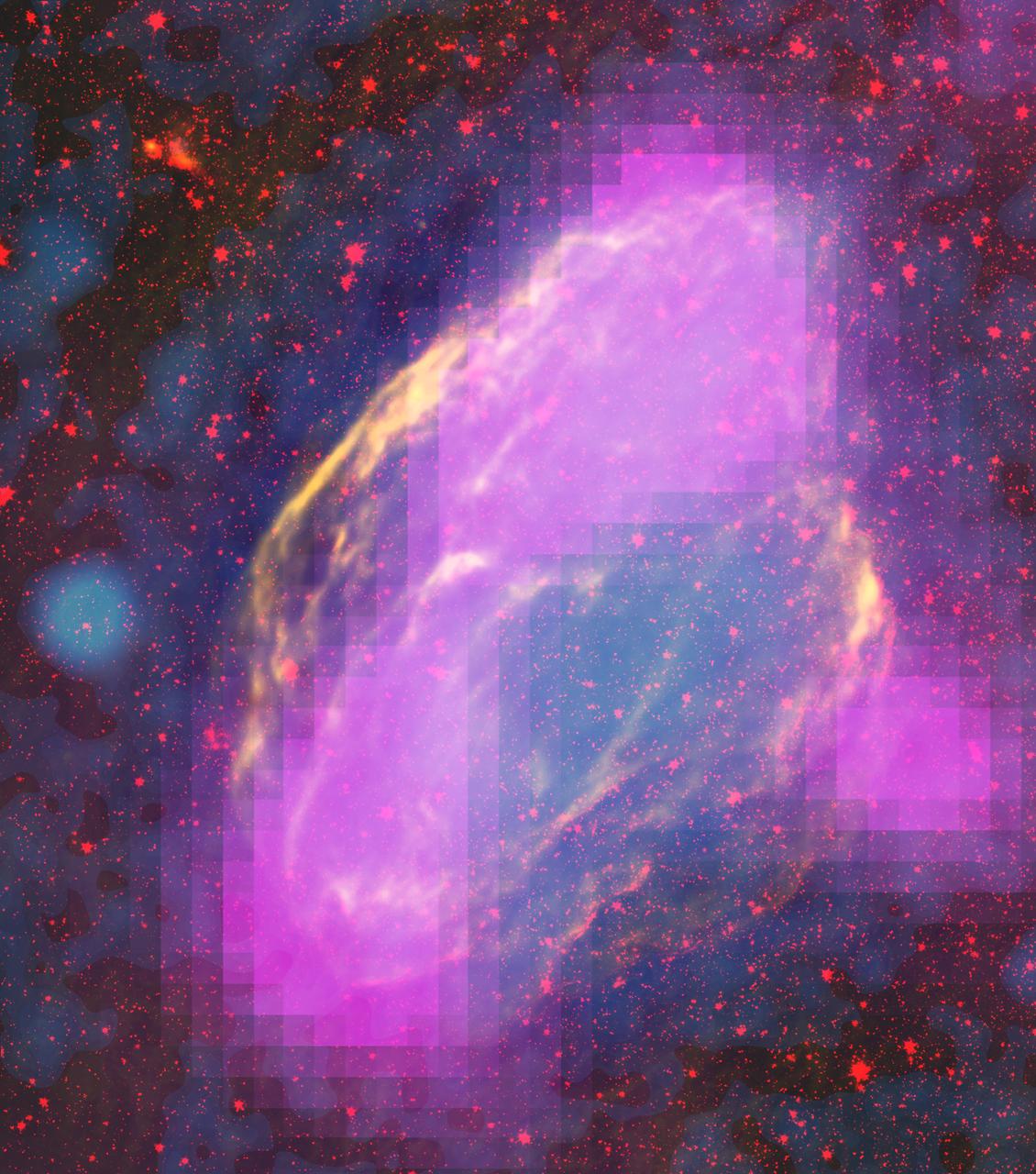
NASA's Fermi Closes on Source of Cosmic Rays New images from NASA's Fermi Gamma-ray Space Telescope show where supernova remnants emit radiation a billion times more energetic than visible light. The images bring astronomers a step closer to understanding the source of some of the universe's most energetic particles -- cosmic rays. Fermi mapped GeV-gamma-ray emission regions (magenta) in the W44 supernova remnant. The features clearly align with filaments detectable in other wavelengths. This composite merges X-rays (blue) from the Germany-led ROSAT mission, infrared (red) from NASA's Spitzer Space Telescope, and radio (orange) from the Very Large Array near Socorro, N.M. Credit: NASA/DOE/Fermi LAT Collaboration, ROSAT, JPL-Caltech, and NRAO/AUI For more information: <a href="http://www.nasa.gov/mission_pages/GLAST/news/cosmic-rays-source.html" rel="nofollow">www.nasa.gov/mission_pages/GLAST/news/cosmic-rays-source....</a>
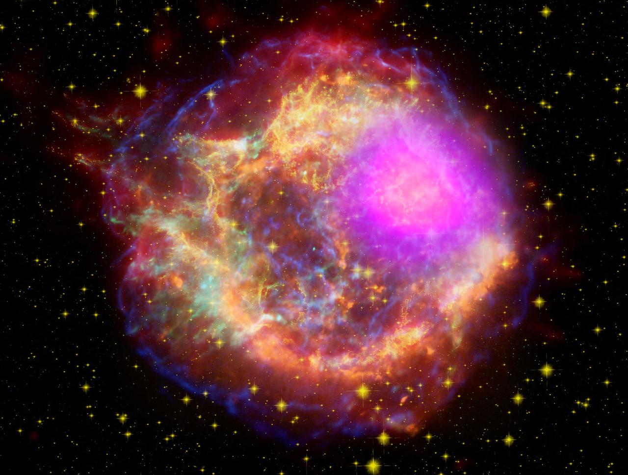
NASA's Fermi Closes on Source of Cosmic Rays New images from NASA's Fermi Gamma-ray Space Telescope show where supernova remnants emit radiation a billion times more energetic than visible light. The images bring astronomers a step closer to understanding the source of some of the universe's most energetic particles -- cosmic rays. This composite shows the Cassiopeia A supernova remnant across the spectrum: Gamma rays (magenta) from NASA's Fermi Gamma-ray Space Telescope; X-rays (blue, green) from NASA's Chandra X-ray Observatory; visible light (yellow) from the Hubble Space Telescope; infrared (red) from NASA's Spitzer Space Telescope; and radio (orange) from the Very Large Array near Socorro, N.M. Credit: NASA/DOE/Fermi LAT Collaboration, CXC/SAO/JPL-Caltech/Steward/O. Krause et al., and NRAO/AUI For more information: <a href="http://www.nasa.gov/mission_pages/GLAST/news/cosmic-rays-source.html" rel="nofollow">www.nasa.gov/mission_pages/GLAST/news/cosmic-rays-source....</a> <b><a href="http://www.nasa.gov/centers/goddard/home/index.html" rel="nofollow">NASA Goddard Space Flight Center</a></b> is home to the nation's largest organization of combined scientists, engineers and technologists that build spacecraft, instruments and new technology to study the Earth, the sun, our solar system, and the universe. <b>Follow us on <a href="http://twitter.com/NASA_GoddardPix" rel="nofollow">Twitter</a></b> <b>Join us on <a href="http://www.facebook.com/pages/Greenbelt-MD/NASA-Goddard/395013845897?ref=tsd" rel="nofollow">Facebook</a><b> </b></b>
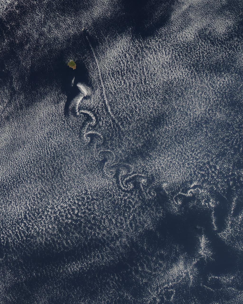
Theodore von Kármán, a Hungarian-American physicist, was the first to describe the physical processes that create long chains of spiral eddies like the one shown above. Known as von Kármán vortices the patterns can form nearly anywhere that fluid flow is disturbed by an object. Since the atmosphere behaves like a fluid, the wing of an airplane, a bridge, even an island can trigger the distinctive phenomenon. On May 22, 2013, the Moderate Resolution Imaging Spectroradiometer (MODIS) on NASA’s Terra satellite captured this natural-color image of cloud vortices behind Isla Socorro, a volcanic island located in the Pacific Ocean. The island, which is located a few hundred kilometers off the west coast of Mexico and the southern tip of Baja California, is part of the Revillagigedo Archipelago. Satellite sensors have spotted von Kármán vortices around the globe, including off of Guadalupe Island, near the coast of Chile, in the Greenland Sea, in the Arctic, and even next to a tropical storm. NASA image courtesy Jeff Schmaltz, LANCE/EOSDIS MODIS Rapid Response Team at NASA GSFC. Caption by Adam Voiland. Instrument: Terra - MODIS More info: <a href="http://1.usa.gov/14VSDQa" rel="nofollow">1.usa.gov/14VSDQa</a> Credit: <b><a href="http://www.earthobservatory.nasa.gov/" rel="nofollow"> NASA Earth Observatory</a></b> <b><a href="http://www.nasa.gov/audience/formedia/features/MP_Photo_Guidelines.html" rel="nofollow">NASA image use policy.</a></b> <b><a href="http://www.nasa.gov/centers/goddard/home/index.html" rel="nofollow">NASA Goddard Space Flight Center</a></b> enables NASA’s mission through four scientific endeavors: Earth Science, Heliophysics, Solar System Exploration, and Astrophysics. Goddard plays a leading role in NASA’s accomplishments by contributing compelling scientific knowledge to advance the Agency’s mission. <b>Follow us on <a href="http://twitter.com/NASA_GoddardPix" rel="nofollow">Twitter</a></b> <b>Like us on <a href="http://www.facebook.com/pages/Greenbelt-MD/NASA-Goddard/395013845897?ref=tsd" rel="nofollow">Facebook</a></b> <b>Find us on <a href="http://instagram.com/nasagoddard?vm=grid" rel="nofollow">Instagram</a></b>
The W44 supernova remnant is nestled within and interacting with the molecular cloud that formed its parent star. Fermi's LAT detects GeV gamma rays (magenta) produced when the gas is bombarded by cosmic rays, primarily protons. Radio observations (yellow) from the Karl G. Jansky Very Large Array near Socorro, N.M., and infrared (red) data from NASA's Spitzer Space Telescope reveal filamentary structures in the remnant's shell. Blue shows X-ray emission mapped by the Germany-led ROSAT mission. To read more go to: <a href="http://1.usa.gov/14V14qi" rel="nofollow">1.usa.gov/14V14qi</a> <b><a href="http://www.nasa.gov/audience/formedia/features/MP_Photo_Guidelines.html" rel="nofollow">NASA image use policy.</a></b> <b><a href="http://www.nasa.gov/centers/goddard/home/index.html" rel="nofollow">NASA Goddard Space Flight Center</a></b> enables NASA’s mission through four scientific endeavors: Earth Science, Heliophysics, Solar System Exploration, and Astrophysics. Goddard plays a leading role in NASA’s accomplishments by contributing compelling scientific knowledge to advance the Agency’s mission. <b>Follow us on <a href="http://twitter.com/NASA_GoddardPix" rel="nofollow">Twitter</a></b> <b>Like us on <a href="http://www.facebook.com/pages/Greenbelt-MD/NASA-Goddard/395013845897?ref=tsd" rel="nofollow">Facebook</a></b> <b>Find us on <a href="http://instagram.com/nasagoddard?vm=grid" rel="nofollow">Instagram</a></b> Credit: NASA/DOE/Fermi LAT Collaboration, NRAO/AUI, JPL-Caltech, ROSAT

NMTSat is a student-built satellite built by undergraduate and graduates students primarily from New Mexico Tech. NMTSat is designed to operate five sensors in four experiments in space for 3 months of data collection. The experiments will provide data on earth’s magnetic field, high altitude plasma density, atmospheric weather measurements, and an optical beacon experiment. Approximately 50 students have contributed to NMTSat and its design not including the students and groups who have developed the science instruments. NMTSat CubeSat is providing the opportunity for these science experiments to be conducted on orbit and demonstrates the collaborative nature of the Educational Launch of Nano Satellite (ELaNa) Program at NASA. The instruments have been contributed by New Mexico Tech, Turabo University in Puerto Rico, Los Alamos National Laboratory, and Atmospheric and Space Technology Research Associates (ASTRA) in Boulder, CO. Dr. Anders M. Jorgensen, Associate Professor at New Mexico Tech is the PI and Dr. Hien Vo from Vietnamese-German University in Ho Chi Minh University in Vietnam is a Co-Investigator. NMTSat is funded by the New Mexico NASA EPSCoR program as well as New Mexico Tech.

NMTSat is a student-built satellite built by undergraduate and graduates students primarily from New Mexico Tech. NMTSat is designed to operate five sensors in four experiments in space for 3 months of data collection. The experiments will provide data on earth’s magnetic field, high altitude plasma density, atmospheric weather measurements, and an optical beacon experiment. Approximately 50 students have contributed to NMTSat and its design not including the students and groups who have developed the science instruments. NMTSat CubeSat is providing the opportunity for these science experiments to be conducted on orbit and demonstrates the collaborative nature of the Educational Launch of Nano Satellite (ELaNa) Program at NASA. The instruments have been contributed by New Mexico Tech, Turabo University in Puerto Rico, Los Alamos National Laboratory, and Atmospheric and Space Technology Research Associates (ASTRA) in Boulder, CO. Dr. Anders M. Jorgensen, Associate Professor at New Mexico Tech is the PI and Dr. Hien Vo from Vietnamese-German University in Ho Chi Minh University in Vietnam is a Co-Investigator. NMTSat is funded by the New Mexico NASA EPSCoR program as well as New Mexico Tech.

NMTSat is a student-built satellite built by undergraduate and graduates students primarily from New Mexico Tech. NMTSat is designed to operate five sensors in four experiments in space for 3 months of data collection. The experiments will provide data on earth’s magnetic field, high altitude plasma density, atmospheric weather measurements, and an optical beacon experiment. Approximately 50 students have contributed to NMTSat and its design not including the students and groups who have developed the science instruments. NMTSat CubeSat is providing the opportunity for these science experiments to be conducted on orbit and demonstrates the collaborative nature of the Educational Launch of Nano Satellite (ELaNa) Program at NASA. The instruments have been contributed by New Mexico Tech, Turabo University in Puerto Rico, Los Alamos National Laboratory, and Atmospheric and Space Technology Research Associates (ASTRA) in Boulder, CO. Dr. Anders M. Jorgensen, Associate Professor at New Mexico Tech is the PI and Dr. Hien Vo from Vietnamese-German University in Ho Chi Minh University in Vietnam is a Co-Investigator. NMTSat is funded by the New Mexico NASA EPSCoR program as well as New Mexico Tech.
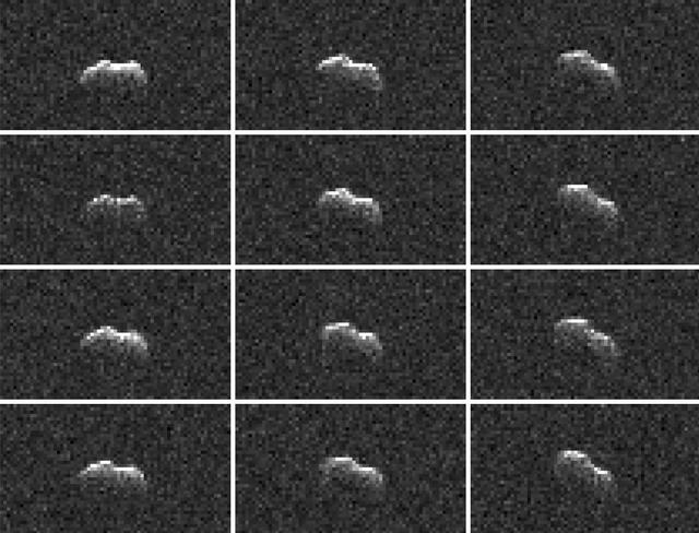
On March 21, 2021, the large asteroid 2001 FO32 made a close approach with our planet, passing at a distance of about 1.25 million miles (2 million kilometers) — or 5 1/4 times the distance from Earth to the Moon. While there was no risk of the near-Earth asteroid colliding with Earth as its orbit is very well known, scientists at NASA's Jet Propulsion Laboratory in Southern California took the opportunity to capture these radar images of the asteroid as it tumbled past. Using NASA's 34-meter (111.5-feet) Deep Space Station 13 (DSS-13) radio antenna at the Deep Space Network's Goldstone Deep Space Communication Complex near Barstow, California, radio signals were transmitted to 2001 FO32. The signals then bounced off the surface of the asteroid and were received by the 100-meter (328-feet) Green Bank Telescope in West Virginia. Such radar observations can offer additional insight into the asteroid's orbit, provide a better estimate of its dimensions and rotation rate, and help glimpse surface features (like large boulders or craters). Other radar observations were carried out by scientists using the 34-meter DSS-43 antenna at the Deep Space Network's Canberra Deep Space Communication Complex in Australia. Along with the Commonwealth Scientific and Industrial Research Organisation's Australia Telescope Compact Array near Narrabri in New South Wales, both antennas worked together to track 2001 FO32. Asteroid 2001 FO32 was discovered in March 2001 by the Lincoln Near-Earth Asteroid Research (LINEAR) program in Socorro, New Mexico, and had been estimated, based on optical measurements, to be roughly 3,000 feet (1 kilometer) wide. In more recent follow-up observations by NEOWISE, 2001 FO32 appears to be faint when observed in infrared wavelengths, which suggests the object is likely less than 1 kilometer in diameter. Analysis by the NEOWISE team shows that it is between 1,300 to 2,230 feet (440 to 680 meters) wide. Further analysis of data from the radar campaign will better refine the size of the asteroid and increase the precision of its orbital calculations. For more information about 2001 FO32 and observing campaign, read: https://www.jpl.nasa.gov/news/asteroid-2001-fo32-will-safely-pass-by-earth-march-21 https://photojournal.jpl.nasa.gov/catalog/PIA24561
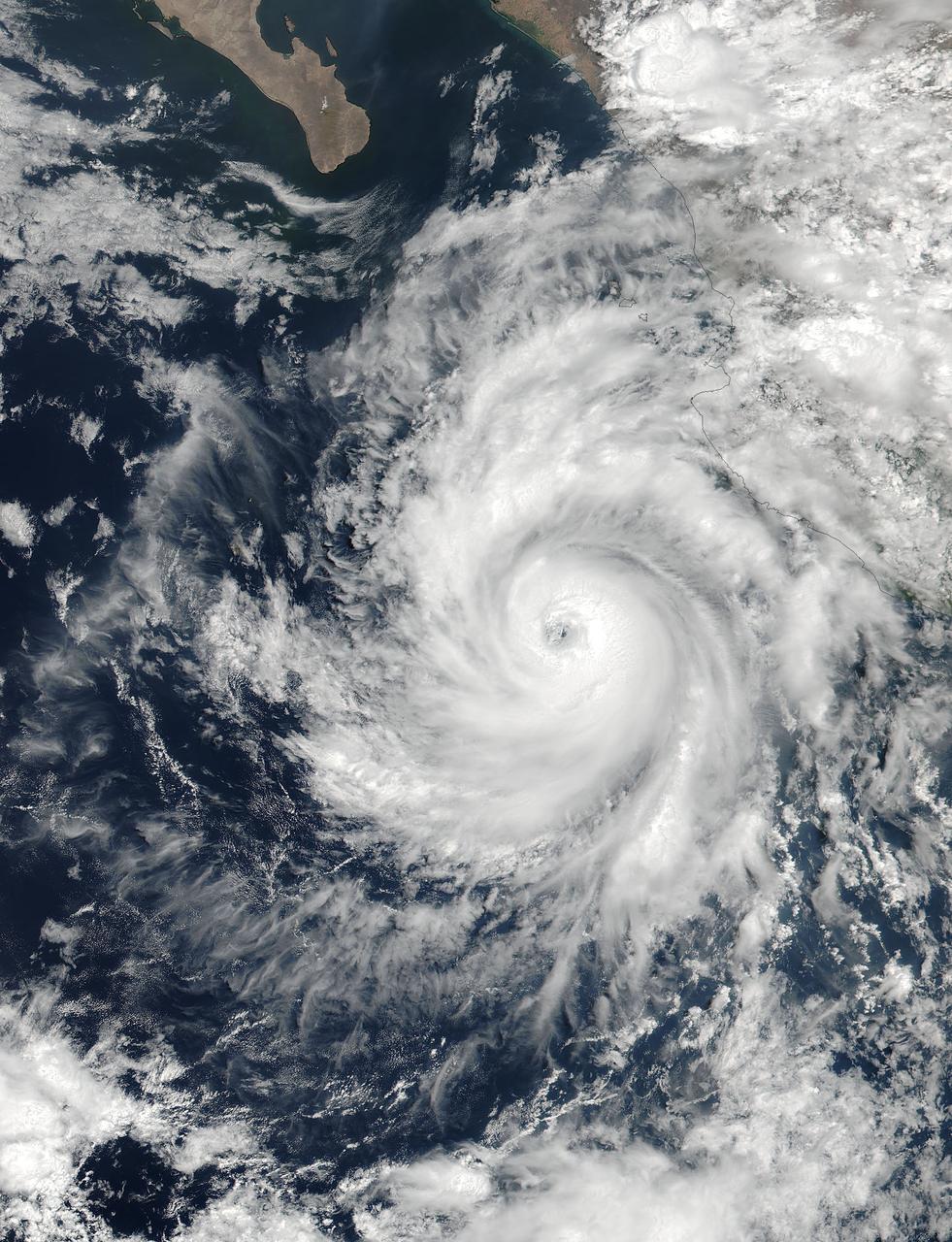
At 19:36 UTC (3:36 p.m. EDT) on June 26, the Visible Infrared Imaging Radiometer Suite (VIIRS) instrument aboard NASA-NOAA's Suomi NPP satellite provided a visible-light image of Hurricane Dora. The VIIRS imagery showed a small hurricane with a visible pinhole eye surrounded by a thick band of powerful thunderstorms. That strength didn't last long as Dora moved over cooler waters and began to weaken early on June 27. Dora appeared degraded in satellite imagery as strong convection and thunderstorms were diminishing, although the storm still maintained a visible eye. At 11 a.m. EDT (1500 UTC) on Tuesday, June 27, Dora's maximum sustained winds have decreased slightly to near 75 mph (120 kph) with higher gusts. Dora is a small tropical cyclone, as hurricane-force winds extended outward up to 15 miles (30 km) from the center. The NHC said the eye of Hurricane Dora was located near latitude 19.3 degrees north and longitude 110.2 degrees west. That's about 250 miles (400 km) south of the southern tip of Baja California, Mexico. Dora was moving toward the west-northwest near 13 mph (20 kph). The NHC said the center of Dora is expected to pass just north of Socorro Island later today, and remain well south of the Baja California Peninsula. Ocean swells generated by Dora are affecting portions of the coast of southwest Mexico and are expected to spread northwestward and begin affecting portions of the coast of the southern Baja California peninsula through Wednesday, June 28. Dora is moving over sea surface temperatures cooler than 26.6 degrees Celsius or 80 degrees Fahrenheit, which is the threshold to maintain a tropical cyclone. Temperatures cooler than that weaken tropical cyclones. The NHC said that the waters beneath Dora will continue to cool for the next couple of days so Dora is expected to weaken to a tropical storm later today, June 27, and degenerate to a remnant low pressure area over the next two days. For updated forecasts, visit: <a href="http://www.nhc.noaa.gov" rel="nofollow">www.nhc.noaa.gov</a>. Credit: NASA/NOAA <b><a href="http://www.nasa.gov/audience/formedia/features/MP_Photo_Guidelines.html" rel="nofollow">NASA image use policy.</a></b> <b><a href="http://www.nasa.gov/centers/goddard/home/index.html" rel="nofollow">NASA Goddard Space Flight Center</a></b> enables NASA’s mission through four scientific endeavors: Earth Science, Heliophysics, Solar System Exploration, and Astrophysics. Goddard plays a leading role in NASA’s accomplishments by contributing compelling scientific knowledge to advance the Agency’s mission. <b>Follow us on <a href="http://twitter.com/NASAGoddardPix" rel="nofollow">Twitter</a></b> <b>Like us on <a href="http://www.facebook.com/pages/Greenbelt-MD/NASA-Goddard/395013845897?ref=tsd" rel="nofollow">Facebook</a></b> <b>Find us on <a href="http://instagrid.me/nasagoddard/?vm=grid" rel="nofollow">Instagram</a></b>