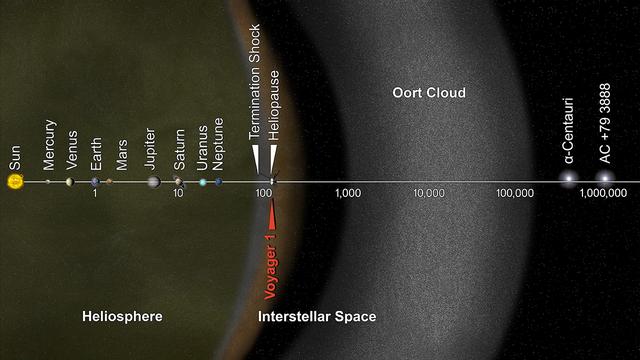
This artist's concept puts solar system distances in perspective. The scale bar is in astronomical units, with each set distance beyond 1 AU representing 10 times the previous distance. One AU is the distance from the sun to the Earth, which is about 93 million miles or 150 million kilometers. Neptune, the most distant planet from the sun, is about 30 AU. Informally, the term "solar system" is often used to mean the space out to the last planet. Scientific consensus, however, says the solar system goes out to the Oort Cloud, the source of the comets that swing by our sun on long time scales. Beyond the outer edge of the Oort Cloud, the gravity of other stars begins to dominate that of the sun. The inner edge of the main part of the Oort Cloud could be as close as 1,000 AU from our sun. The outer edge is estimated to be around 100,000 AU. NASA's Voyager 1, humankind's most distant spacecraft, is around 125 AU. Scientists believe it entered interstellar space, or the space between stars, on Aug. 25, 2012. Much of interstellar space is actually inside our solar system. It will take about 300 years for Voyager 1 to reach the inner edge of the Oort Cloud and possibly about 30,000 years to fly beyond it. Alpha Centauri is currently the closest star to our solar system. But, in 40,000 years, Voyager 1 will be closer to the star AC +79 3888 than to our own sun. AC +79 3888 is actually traveling faster toward Voyager 1 than the spacecraft is traveling toward it. The Voyager spacecraft were built and continue to be operated by NASA's Jet Propulsion Laboratory, in Pasadena, Calif. Caltech manages JPL for NASA. The Voyager missions are a part of NASA's Heliophysics System Observatory, sponsored by the Heliophysics Division of the Science Mission Directorate at NASA Headquarters in Washington. For more information about Voyager, visit: <a href="http://www.nasa.gov/voyager" rel="nofollow">www.nasa.gov/voyager</a> and <a href="http://voyager.jpl.nasa.gov" rel="nofollow">voyager.jpl.nasa.gov</a> . Image credit: NASA/JPL-Caltech <b><a href="http://www.nasa.gov/audience/formedia/features/MP_Photo_Guidelines.html" rel="nofollow">NASA image use policy.</a></b> <b><a href="http://www.nasa.gov/centers/goddard/home/index.html" rel="nofollow">NASA Goddard Space Flight Center</a></b> enables NASA’s mission through four scientific endeavors: Earth Science, Heliophysics, Solar System Exploration, and Astrophysics. Goddard plays a leading role in NASA’s accomplishments by contributing compelling scientific knowledge to advance the Agency’s mission. <b>Follow us on <a href="http://twitter.com/NASAGoddardPix" rel="nofollow">Twitter</a></b> <b>Like us on <a href="http://www.facebook.com/pages/Greenbelt-MD/NASA-Goddard/395013845897?ref=tsd" rel="nofollow">Facebook</a></b> <b>Find us on <a href="http://instagram.com/nasagoddard?vm=grid" rel="nofollow">Instagram</a></b>
This simulated view, made using NASA's Eyes on the Solar System app, approximates Voyager 1's perspective when it took its final series of images known as the "Family Portrait of the Solar System," including the "Pale Blue Dot" image. https://photojournal.jpl.nasa.gov/catalog/PIA23681
This frame from a video demonstrates how NASA Wide-field Infrared Survey Explorer surveys asteroids and comets in the solar system. Perspective shown here is looking down from high above Earth North Pole, a kind of bird eye view of the solar system.

This artist's concept puts solar system distances -- and the travels of NASA's Voyager 2 spacecraft -- in perspective. The scale bar is in astronomical units, with each set distance beyond 1 AU representing 10 times the previous distance. One AU is the distance from the Sun to Earth, which is about 93 million miles, or 150 million kilometers. Neptune, the most distant planet from the Sun, is about 30 AU. Much of the solar system is actually in interstellar space. Informally, the term "solar system" is often used to mean the space out to the last planet. Scientific consensus, however, says the solar system goes out to the Oort Cloud, the source of the comets that swing by our sun on long time scales. Beyond the outer edge of the Oort Cloud, the gravity of other stars begins to dominate that of the Sun. The inner edge of the main part of the Oort Cloud could be as close as 1,000 AU from our Sun. The outer edge is estimated to be around 100,000 AU. Voyager 2, the second farthest human-made object after Voyager 1, is around 119 AU from the Sun. Indications from the scientific instruments suggest Voyager 2 passed beyond our heliosphere (the bubble of plasma the Sun blows around itself) and into interstellar space (the space between stars) in November 2018. The heliosphere has a turbulent outer boundary known as the heliosheath. The termination shock is the inner boundary of the heliosheath and the heliopause is the outer boundary, beyond which lies interstellar space. Voyager 2 crossed the termination shock at 84 AU in August 2007. It will take about 300 years for Voyager 2 to reach the inner edge of the Oort Cloud and possibly about 30,000 years to fly beyond it. Voyager 2 is heading away from the Sun about 36 degrees out of the ecliptic plane (plane of the planets) to the south, toward the constellations of Sagittarius and Pavo. In about 40,000 years, Voyager 2 will be closer to another star than our own Sun, coming within about 1.7 light years of a star called Ross 248, a small star in the constellation of Andromeda. https://photojournal.jpl.nasa.gov/catalog/PIA22921
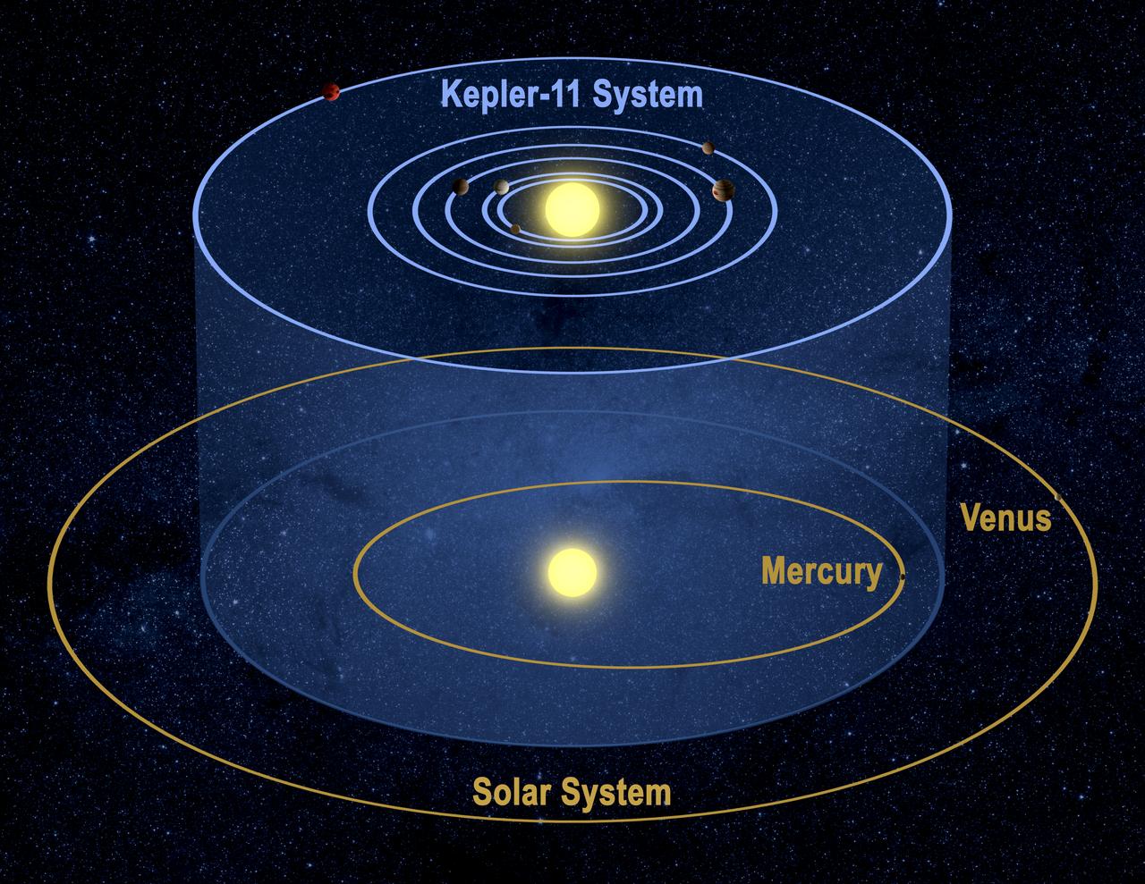
This artist's conception shows the Kepler-11 planetary system and our solar system from a tilted perspective to demonstrate that the orbits of each lie on similar planes. Image credit: NASA/Tim Pyle
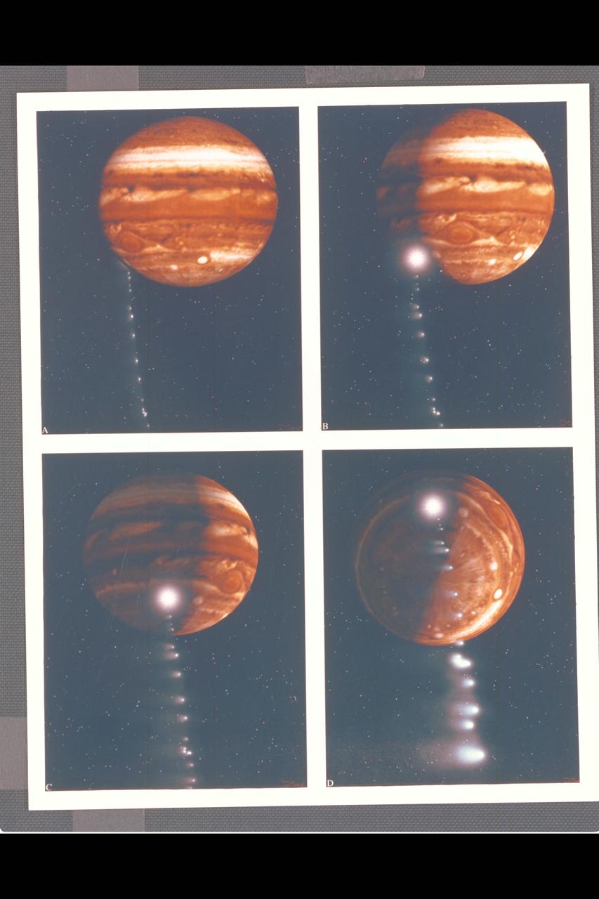
Photo Artwork composite by JPL This depiction of comet Shoemaker-Levy 9 impacting Jupiter is shown from several perspectives. IMAGE A is shown from the perspective of Earth based observers. IMAGE B shows the perspective from Galileo spacecraft which can observe the impact point directly. IMAGE C is shown from the Voyager 2 spacecraft, which may observe the event from its unique position at the outer reaches of the solar system. IMAGE D depicts a generic view from Jupiter's south pole. For visual appeal, most of the large cometary fragments are shown close to one another in this image. At the time of Jupiter impact, the fragments will be separated from one another by serveral times the distances shown. This image was created by D.A. Seal of JPL's Mission Design Section using orbital computations provIded by P.W. Chodas and D.K. Yeomans of JPL's Navigation Section.
S89-48714 (18 Oct 1989) --- This photograph was taken by the STS-34 crew aboard the Space Shuttle Atlantis and shows the Galileo spacecraft being deployed on Oct. 18, 1989 from the payload bay. Galileo is a scientific craft that will go into orbit around the planet Jupiter and drop a probe into its atmosphere in search of primordial solar system material believed to be present there. The 70mm motion picture film will be used in the forthcoming "Blue Planet," which will address Earth's environmental problems from the perspective of space-based observation and solar system exploration. The film is being produced by IMAX Space Technology Inc. for the sponsor, the Smithsonian Institution, with funding provided by the Lockheed Corporation. PHOTO CREDIT: NASA/Smithsonian Institution
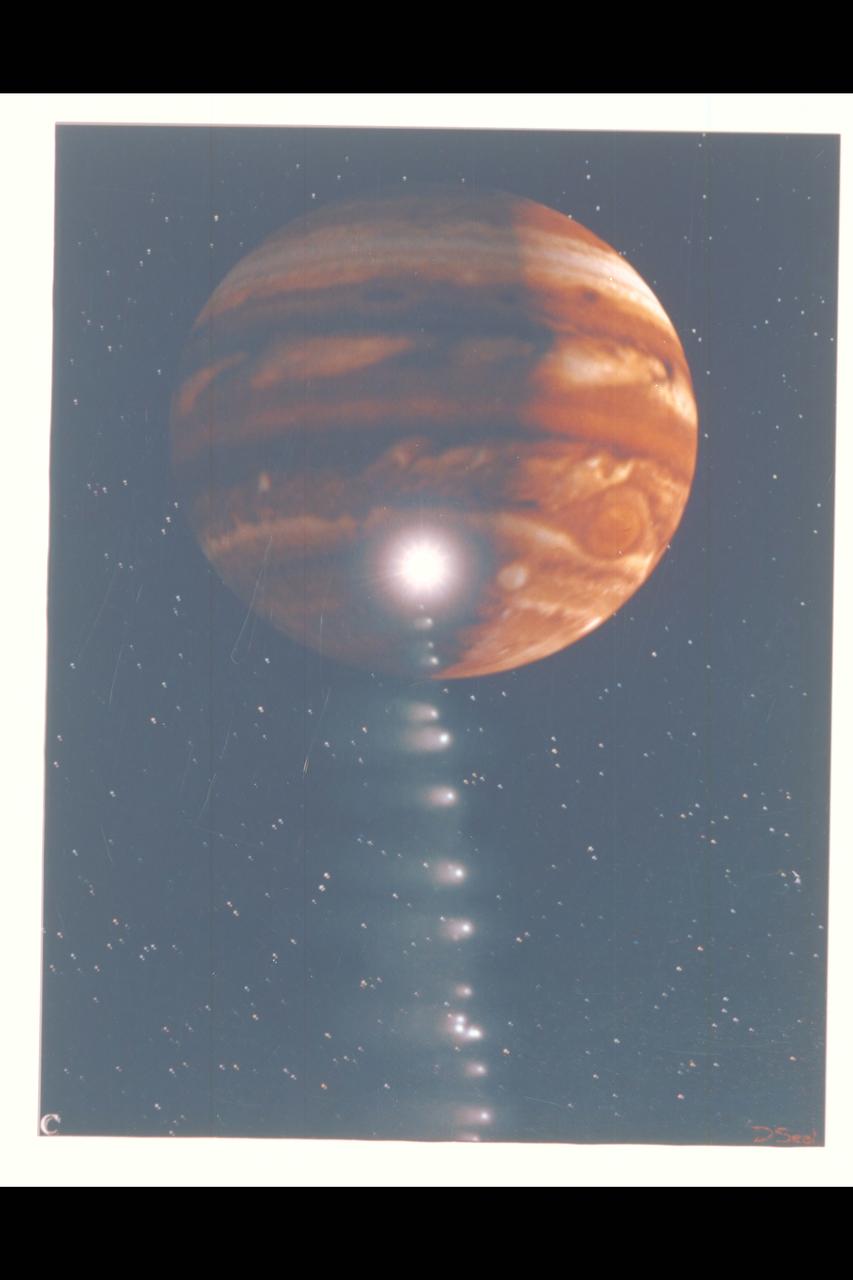
Photo Artwork composite by JPL This depiction of comet Shoemaker-Levy 9 impacting Jupiter is shown from several perspectives. IMAGE C is shown from the Voyager 2 spacecraft, which may observe the event from its unique position at the outer reaches of the solar system. For visual appeal, most of the large cometary fragments are shown close to one another in this image. At the time of Jupiter impact, the fragments will be separated from one another by serveral times the distances shown. This image was created by D.A. Seal of JPL's Mission Design Section using orbital computations provIded by P.W. Chodas and D.K. Yeomans of JPL's Navigation Section.
Date acquired: April 05, 2013 This striking image of Kuiper shows the crater in a new perspective. This image highlights the crater's smooth impact melt and central peaks. Kuiper, first seen by Mariner 10, is an easily identifiable feature on Mercury's surface due to its bright rays, similar to Hokusai. This image was acquired as a high-resolution targeted observation. Targeted observations are images of a small area on Mercury's surface at resolutions much higher than the 200-meter/pixel morphology base map. It is not possible to cover all of Mercury's surface at this high resolution, but typically several areas of high scientific interest are imaged in this mode each week. The MESSENGER spacecraft is the first ever to orbit the planet Mercury, and the spacecraft's seven scientific instruments and radio science investigation are unraveling the history and evolution of the Solar System's innermost planet. During the first two years of orbital operations, MESSENGER acquired over 150,000 images and extensive other data sets. MESSENGER is capable of continuing orbital operations until early 2015. Credit: NASA/Johns Hopkins University Applied Physics Laboratory/Carnegie Institution of Washington

This color image of the sun, Earth and Venus was taken by the Voyager 1 spacecraft Feb. 14, 1990, when it was approximately 32 degrees above the plane of the ecliptic and at a slant-range distance of approximately 4 billion miles. It is the first -- and may be the only -- time that we will ever see our solar system from such a vantage point. The image is a portion of a wide-angle image containing the sun and the region of space where the Earth and Venus were at the time with two narrow-angle pictures centered on each planet. The wide-angle was taken with the camera's darkest filter (a methane absorption band), and the shortest possible exposure (5 thousandths of a second) to avoid saturating the camera's vidicon tube with scattered sunlight. The sun is not large in the sky as seen from Voyager's perspective at the edge of the solar system but is still eight million times brighter than the brightest star in Earth's sky, Sirius. The image of the sun you see is far larger than the actual dimension of the solar disk. The result of the brightness is a bright burned out image with multiple reflections from the optics in the camera. The "rays" around the sun are a diffraction pattern of the calibration lamp which is mounted in front of the wide angle lens. The two narrow-angle frames containing the images of the Earth and Venus have been digitally mosaiced into the wide-angle image at the appropriate scale. These images were taken through three color filters and recombined to produce a color image. The violet, green and blue filters were used; exposure times were, for the Earth image, 0.72, 0.48 and 0.72 seconds, and for the Venus frame, 0.36, 0.24 and 0.36, respectively. Although the planetary pictures were taken with the narrow-angle camera (1500 mm focal length) and were not pointed directly at the sun, they show the effects of the glare from the nearby sun, in the form of long linear streaks resulting from the scattering of sunlight off parts of the camera and its sun shade. From Voyager's great distance both Earth and Venus are mere points of light, less than the size of a picture element even in the narrow-angle camera. Earth was a crescent only 0.12 pixel in size. Coincidentally, Earth lies right in the center of one of the scattered light rays resulting from taking the image so close to the sun. Detailed analysis also suggests that Voyager detected the moon as well, but it is too faint to be seen without special processing. Venus was only 0.11 pixel in diameter. The faint colored structure in both planetary frames results from sunlight scattered in the optics. http://photojournal.jpl.nasa.gov/catalog/PIA00450
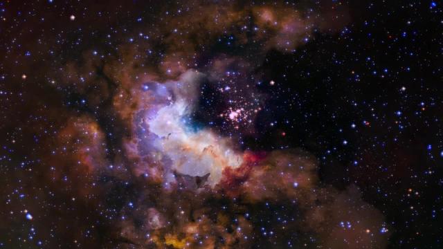
This visualization provides a three-dimensional perspective on Hubble's 25th anniversary image of the nebula Gum 29 with the star cluster Westerlund 2 at its core. The flight traverses the foreground stars and approaches the lower left rim of the nebula Gum 29. Passing through the wispy darker clouds on the near side, the journey reveals bright gas illuminated by the intense radiation of the newly formed stars of cluster Westerlund 2. Within the nebula, several pillars of dark, dense gas are being shaped by the energetic light and strong stellar winds from the brilliant cluster of thousands of stars. Note that the visualization is intended to be a scientifically reasonable interpretation and that distances within the model are significantly compressed. Download here: <a href="http://hubblesite.org/newscenter/archive/releases/2015/12/video/" rel="nofollow">hubblesite.org/newscenter/archive/releases/2015/12/video/</a> Credit: NASA, ESA, G. Bacon, L. Frattare, Z. Levay, and F. Summers (Viz3D Team, STScI), and J. Anderson (STScI) Acknowledgment: The Hubble Heritage Team (STScI/AURA), A. Nota (ESA/STScI), the Westerlund 2 Science Team, and ESO <b><a href="http://www.nasa.gov/audience/formedia/features/MP_Photo_Guidelines.html" rel="nofollow">NASA image use policy.</a></b> <b><a href="http://www.nasa.gov/centers/goddard/home/index.html" rel="nofollow">NASA Goddard Space Flight Center</a></b> enables NASA’s mission through four scientific endeavors: Earth Science, Heliophysics, Solar System Exploration, and Astrophysics. Goddard plays a leading role in NASA’s accomplishments by contributing compelling scientific knowledge to advance the Agency’s mission. <b>Follow us on <a href="http://twitter.com/NASAGoddardPix" rel="nofollow">Twitter</a></b> <b>Like us on <a href="http://www.facebook.com/pages/Greenbelt-MD/NASA-Goddard/395013845897?ref=tsd" rel="nofollow">Facebook</a></b> <b>Find us on <a href="http://instagrid.me/nasagoddard/?vm=grid" rel="nofollow">Instagram</a></b>
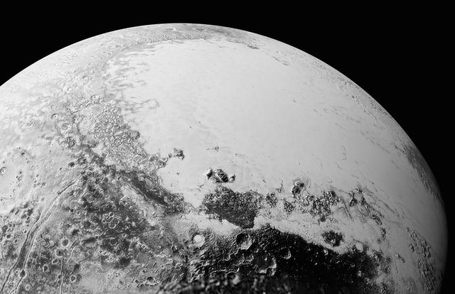
This synthetic perspective view of Pluto, based on the latest high-resolution images to be downlinked from NASA’s New Horizons spacecraft, shows what you would see if you were approximately 1,100 miles (1,800 kilometers) above Pluto’s equatorial area, looking northeast over the dark, cratered, informally named Cthulhu Regio toward the bright, smooth, expanse of icy plains informally called Sputnik Planum. The entire expanse of terrain seen in this image is 1,100 miles (1,800 kilometers) across. The images were taken as New Horizons flew past Pluto on July 14, 2015, from a distance of 50,000 miles (80,000 kilometers). Read more: <a href="http://1.usa.gov/1MgG7io" rel="nofollow">1.usa.gov/1MgG7io</a> Credit: NASA/Johns Hopkins University Applied Physics Laboratory/Southwest Research Institute <b><a href="http://www.nasa.gov/audience/formedia/features/MP_Photo_Guidelines.html" rel="nofollow">NASA image use policy.</a></b> <b><a href="http://www.nasa.gov/centers/goddard/home/index.html" rel="nofollow">NASA Goddard Space Flight Center</a></b> enables NASA’s mission through four scientific endeavors: Earth Science, Heliophysics, Solar System Exploration, and Astrophysics. Goddard plays a leading role in NASA’s accomplishments by contributing compelling scientific knowledge to advance the Agency’s mission. <b>Follow us on <a href="http://twitter.com/NASAGoddardPix" rel="nofollow">Twitter</a></b> <b>Like us on <a href="http://www.facebook.com/pages/Greenbelt-MD/NASA-Goddard/395013845897?ref=tsd" rel="nofollow">Facebook</a></b> <b>Find us on <a href="http://instagrid.me/nasagoddard/?vm=grid" rel="nofollow">Instagram</a></b>
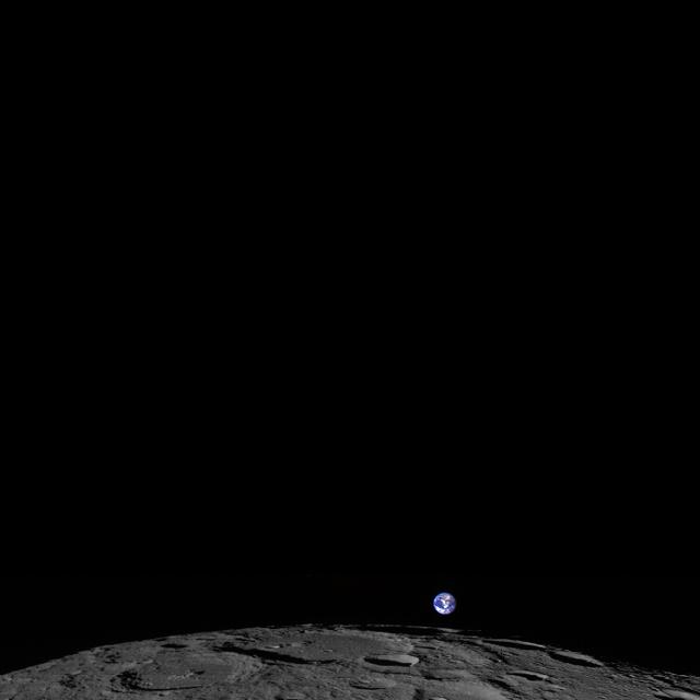
This image, captured Feb. 1, 2014, shows a colorized view of Earth from the moon-based perspective of NASA's Lunar Reconnaissance Orbiter. Credit: NASA/Goddard/Arizona State University -- NASA's Lunar Reconnaissance Orbiter (LRO) experiences 12 "earthrises" every day, however LROC (short for LRO Camera) is almost always busy imaging the lunar surface so only rarely does an opportunity arise such that LROC can capture a view of Earth. On Feb. 1, 2014, LRO pitched forward while approaching the moon's north pole allowing the LROC Wide Angle Camera to capture Earth rising above Rozhdestvenskiy crater (112 miles, or 180 km, in diameter). Read more: <a href="http://go.nasa.gov/1oqMlgu" rel="nofollow">go.nasa.gov/1oqMlgu</a> <b><a href="http://www.nasa.gov/audience/formedia/features/MP_Photo_Guidelines.html" rel="nofollow">NASA image use policy.</a></b> <b><a href="http://www.nasa.gov/centers/goddard/home/index.html" rel="nofollow">NASA Goddard Space Flight Center</a></b> enables NASA’s mission through four scientific endeavors: Earth Science, Heliophysics, Solar System Exploration, and Astrophysics. Goddard plays a leading role in NASA’s accomplishments by contributing compelling scientific knowledge to advance the Agency’s mission. <b>Follow us on <a href="http://twitter.com/NASAGoddardPix" rel="nofollow">Twitter</a></b> <b>Like us on <a href="http://www.facebook.com/pages/Greenbelt-MD/NASA-Goddard/395013845897?ref=tsd" rel="nofollow">Facebook</a></b> <b>Find us on <a href="http://instagram.com/nasagoddard?vm=grid" rel="nofollow">Instagram</a></b>

The greens and blues of the ocean color from NASA satellite data have provided new insights into how climate and ecosystem processes affect the growth cycles of phytoplankton—microscopic aquatic plants important for fish populations and Earth’s carbon cycle. At the bottom of the ocean’s food chain, phytoplankton account for roughly half of the net photosynthesis on Earth. Their photosynthesis consumes carbon dioxide and plays a key role in transferring carbon from the atmosphere to the ocean. Unlike the plant ecosystems on land, the amount of phytoplankton in the ocean is always followed closely by the abundance of organisms that eat phytoplankton, creating a perpetual dance between predators and prey. This new analysis shows how tiny imbalances in this predator-prey relationship, caused by environmental variability, give rise to massive phytoplankton blooms, having huge impacts on ocean productivity, fisheries and carbon cycling. The study was released Thursday, Sept. 25, in the journal Nature Climate Change. “The continuous year-in and year-out measurements provided by NASA’s ocean color satellites have dramatically changed our understanding of phytoplankton dynamics on the Earth,” said Mike Behrenfeld, author of the study and phytoplankton ecologist at Oregon State University, Corvallis, Oregon. “What we now see is a closely linked system of phytoplankton cell division and consumption lying at the heart of the plant’s annual cycle.” Behrenfeld calls this close predator-prey relationship the “Dance of the Plankton.” This view is different from previous perspectives that have simply focused on environmental resources used by phytoplankton to grow, such as nutrients and light. The new view is important because it reveals that tiny imbalances can greatly impact Earth’s ecology. Read more: <a href="http://1.usa.gov/ZkVMHG" rel="nofollow">1.usa.gov/ZkVMHG</a> Credit: NASA's Goddard Space Flight Center, Norman Kuring; USGS <b><a href="http://www.nasa.gov/audience/formedia/features/MP_Photo_Guidelines.html" rel="nofollow">NASA image use policy.</a></b> <b><a href="http://www.nasa.gov/centers/goddard/home/index.html" rel="nofollow">NASA Goddard Space Flight Center</a></b> enables NASA’s mission through four scientific endeavors: Earth Science, Heliophysics, Solar System Exploration, and Astrophysics. Goddard plays a leading role in NASA’s accomplishments by contributing compelling scientific knowledge to advance the Agency’s mission. <b>Follow us on <a href="http://twitter.com/NASAGoddardPix" rel="nofollow">Twitter</a></b> <b>Like us on <a href="http://www.facebook.com/pages/Greenbelt-MD/NASA-Goddard/395013845897?ref=tsd" rel="nofollow">Facebook</a></b> <b>Find us on <a href="http://instagram.com/nasagoddard?vm=grid" rel="nofollow">Instagram</a></b>
This sprinkle of cosmic glitter is a blue compact dwarf galaxy known as Markarian 209. Galaxies of this type are blue-hued, compact in size, gas-rich, and low in heavy elements. They are often used by astronomers to study star formation, as their conditions are similar to those thought to exist in the early Universe. Markarian 209 in particular has been studied extensively. It is filled with diffuse gas and peppered with star-forming regions towards its core. This image captures it undergoing a particularly dramatic burst of star formation, visible as the lighter blue cloudy region towards the top right of the galaxy. This clump is filled with very young and hot newborn stars. This galaxy was initially thought to be a young galaxy undergoing its very first episode of star formation, but later research showed that Markarian 209 is actually very old, with an almost continuous history of forming new stars. It is thought to have never had a dormant period — a period during which no stars were formed — lasting longer than 100 million years. The dominant population of stars in Markarian 209 is still quite young, in stellar terms, with ages of under 3 million years. For comparison, the sun is some 4.6 billion years old, and is roughly halfway through its expected lifespan. The observations used to make this image were taken using Hubble’s Wide Field Camera 3 and Advanced Camera for Surveys, and span the ultraviolet, visible, and infrared parts of the spectrum. A scattering of other bright galaxies can be seen across the frame, including the bright golden oval that could, due to a trick of perspective, be mistaken as part of Markarian 209 but is in fact a background galaxy. Credit: ESA/Hubble & NASA Acknowledgement: Nick Rose <b><a href="http://www.nasa.gov/audience/formedia/features/MP_Photo_Guidelines.html" rel="nofollow">NASA image use policy.</a></b> <b><a href="http://www.nasa.gov/centers/goddard/home/index.html" rel="nofollow">NASA Goddard Space Flight Center</a></b> enables NASA’s mission through four scientific endeavors: Earth Science, Heliophysics, Solar System Exploration, and Astrophysics. Goddard plays a leading role in NASA’s accomplishments by contributing compelling scientific knowledge to advance the Agency’s mission. <b>Follow us on <a href="http://twitter.com/NASAGoddardPix" rel="nofollow">Twitter</a></b> <b>Like us on <a href="http://www.facebook.com/pages/Greenbelt-MD/NASA-Goddard/395013845897?ref=tsd" rel="nofollow">Facebook</a></b> <b>Find us on <a href="http://instagram.com/nasagoddard?vm=grid" rel="nofollow">Instagram</a></b>
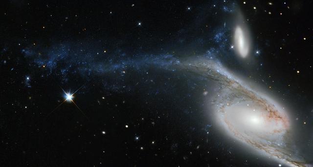
This picture, taken by the NASA/ESA Hubble Space Telescope’s Wide Field Planetary Camera 2 (WFPC2), shows a galaxy known as NGC 6872 in the constellation of Pavo (The Peacock). Its unusual shape is caused by its interactions with the smaller galaxy that can be seen just above NGC 6872, called IC 4970. They both lie roughly 300 million light-years away from Earth. From tip to tip, NGC 6872 measures over 500,000 light-years across, making it the second largest spiral galaxy discovered to date. In terms of size it is beaten only by NGC 262, a galaxy that measures a mind-boggling 1.3 million light-years in diameter! To put that into perspective, our own galaxy, the Milky Way, measures between 100,000 and 120,000 light-years across, making NGC 6872 about five times its size. The upper left spiral arm of NGC 6872 is visibly distorted and is populated by star-forming regions, which appear blue on this image. This may have been be caused by IC 4970 recently passing through this arm — although here, recent means 130 million years ago! Astronomers have noted that NGC 6872 seems to be relatively sparse in terms of free hydrogen, which is the basis material for new stars, meaning that if it weren’t for its interactions with IC 4970, NGC 6872 might not have been able to produce new bursts of star formation. Credit: Image credit: ESA/Hubble & NASA / Acknowledgement: Judy Schmidt <b><a href="http://www.nasa.gov/audience/formedia/features/MP_Photo_Guidelines.html" rel="nofollow">NASA image use policy.</a></b> <b><a href="http://www.nasa.gov/centers/goddard/home/index.html" rel="nofollow">NASA Goddard Space Flight Center</a></b> enables NASA’s mission through four scientific endeavors: Earth Science, Heliophysics, Solar System Exploration, and Astrophysics. Goddard plays a leading role in NASA’s accomplishments by contributing compelling scientific knowledge to advance the Agency’s mission. <b>Follow us on <a href="http://twitter.com/NASAGoddardPix" rel="nofollow">Twitter</a></b> <b>Like us on <a href="http://www.facebook.com/pages/Greenbelt-MD/NASA-Goddard/395013845897?ref=tsd" rel="nofollow">Facebook</a></b> <b>Find us on <a href="http://instagram.com/nasagoddard?vm=grid" rel="nofollow">Instagram</a></b>

This planetary nebula's simple, graceful appearance is thought to be due to perspective: our view from Earth looking straight into what is actually a barrel-shaped cloud of gas shrugged off by a dying central star. Hot blue gas near the energizing central star gives way to progressively cooler green and yellow gas at greater distances with the coolest red gas along the outer boundary. Credit: NASA/Hubble Heritage Team ---- The Ring Nebula's distinctive shape makes it a popular illustration for astronomy books. But new observations by NASA's Hubble Space Telescope of the glowing gas shroud around an old, dying, sun-like star reveal a new twist. "The nebula is not like a bagel, but rather, it's like a jelly doughnut, because it's filled with material in the middle," said C. Robert O'Dell of Vanderbilt University in Nashville, Tenn. He leads a research team that used Hubble and several ground-based telescopes to obtain the best view yet of the iconic nebula. The images show a more complex structure than astronomers once thought and have allowed them to construct the most precise 3-D model of the nebula. "With Hubble's detail, we see a completely different shape than what's been thought about historically for this classic nebula," O'Dell said. "The new Hubble observations show the nebula in much clearer detail, and we see things are not as simple as we previously thought." The Ring Nebula is about 2,000 light-years from Earth and measures roughly 1 light-year across. Located in the constellation Lyra, the nebula is a popular target for amateur astronomers. Read more: <a href="http://1.usa.gov/14VAOMk" rel="nofollow">1.usa.gov/14VAOMk</a> <b><a href="http://www.nasa.gov/audience/formedia/features/MP_Photo_Guidelines.html" rel="nofollow">NASA image use policy.</a></b> <b><a href="http://www.nasa.gov/centers/goddard/home/index.html" rel="nofollow">NASA Goddard Space Flight Center</a></b> enables NASA’s mission through four scientific endeavors: Earth Science, Heliophysics, Solar System Exploration, and Astrophysics. Goddard plays a leading role in NASA’s accomplishments by contributing compelling scientific knowledge to advance the Agency’s mission. <b>Follow us on <a href="http://twitter.com/NASAGoddardPix" rel="nofollow">Twitter</a></b> <b>Like us on <a href="http://www.facebook.com/pages/Greenbelt-MD/NASA-Goddard/395013845897?ref=tsd" rel="nofollow">Facebook</a></b> <b>Find us on <a href="http://instagram.com/nasagoddard?vm=grid" rel="nofollow">Instagram</a></b>
![This new NASA/ESA Hubble Space Telescope image shows a variety of intriguing cosmic phenomena. Surrounded by bright stars, towards the upper middle of the frame we see a small young stellar object (YSO) known as SSTC2D J033038.2+303212. Located in the constellation of Perseus, this star is in the early stages of its life and is still forming into a fully-grown star. In this view from Hubble’s Advanced Camera for Surveys(ACS) it appears to have a murky chimney of material emanating outwards and downwards, framed by bright bursts of gas flowing from the star itself. This fledgling star is actually surrounded by a bright disk of material swirling around it as it forms — a disc that we see edge-on from our perspective. However, this small bright speck is dwarfed by its cosmic neighbor towards the bottom of the frame, a clump of bright, wispy gas swirling around as it appears to spew dark material out into space. The bright cloud is a reflection nebula known as [B77] 63, a cloud of interstellar gas that is reflecting light from the stars embedded within it. There are actually a number of bright stars within [B77] 63, most notably the emission-line star LkHA 326, and it nearby neighbor LZK 18. These stars are lighting up the surrounding gas and sculpting it into the wispy shape seen in this image. However, the most dramatic part of the image seems to be a dark stream of smoke piling outwards from [B77] 63 and its stars — a dark nebula called Dobashi 4173. Dark nebulae are incredibly dense clouds of pitch-dark material that obscure the patches of sky behind them, seemingly creating great rips and eerily empty chunks of sky. The stars speckled on top of this extreme blackness actually lie between us and Dobashi 4173. Credit: ESA/NASA <b><a href="http://www.nasa.gov/audience/formedia/features/MP_Photo_Guidelines.html" rel="nofollow">NASA image use policy.</a></b> <b><a href="http://www.nasa.gov/centers/goddard/home/index.html" rel="nofollow">NASA Goddard Space Flight Center</a></b> enables NASA’s mission through four scientific endeavors: Earth Science, Heliophysics, Solar System Exploration, and Astrophysics. Goddard plays a leading role in NASA’s accomplishments by contributing compelling scientific knowledge to advance the Agency’s mission. <b>Follow us on <a href="http://twitter.com/NASAGoddardPix" rel="nofollow">Twitter</a></b> <b>Like us on <a href="http://www.facebook.com/pages/Greenbelt-MD/NASA-Goddard/395013845897?ref=tsd" rel="nofollow">Facebook</a></b> <b>Find us on <a href="http://instagram.com/nasagoddard?vm=grid" rel="nofollow">Instagram</a></b>](https://images-assets.nasa.gov/image/GSFC_20171208_Archive_e000999/GSFC_20171208_Archive_e000999~medium.jpg)
This new NASA/ESA Hubble Space Telescope image shows a variety of intriguing cosmic phenomena. Surrounded by bright stars, towards the upper middle of the frame we see a small young stellar object (YSO) known as SSTC2D J033038.2+303212. Located in the constellation of Perseus, this star is in the early stages of its life and is still forming into a fully-grown star. In this view from Hubble’s Advanced Camera for Surveys(ACS) it appears to have a murky chimney of material emanating outwards and downwards, framed by bright bursts of gas flowing from the star itself. This fledgling star is actually surrounded by a bright disk of material swirling around it as it forms — a disc that we see edge-on from our perspective. However, this small bright speck is dwarfed by its cosmic neighbor towards the bottom of the frame, a clump of bright, wispy gas swirling around as it appears to spew dark material out into space. The bright cloud is a reflection nebula known as [B77] 63, a cloud of interstellar gas that is reflecting light from the stars embedded within it. There are actually a number of bright stars within [B77] 63, most notably the emission-line star LkHA 326, and it nearby neighbor LZK 18. These stars are lighting up the surrounding gas and sculpting it into the wispy shape seen in this image. However, the most dramatic part of the image seems to be a dark stream of smoke piling outwards from [B77] 63 and its stars — a dark nebula called Dobashi 4173. Dark nebulae are incredibly dense clouds of pitch-dark material that obscure the patches of sky behind them, seemingly creating great rips and eerily empty chunks of sky. The stars speckled on top of this extreme blackness actually lie between us and Dobashi 4173. Credit: ESA/NASA <b><a href="http://www.nasa.gov/audience/formedia/features/MP_Photo_Guidelines.html" rel="nofollow">NASA image use policy.</a></b> <b><a href="http://www.nasa.gov/centers/goddard/home/index.html" rel="nofollow">NASA Goddard Space Flight Center</a></b> enables NASA’s mission through four scientific endeavors: Earth Science, Heliophysics, Solar System Exploration, and Astrophysics. Goddard plays a leading role in NASA’s accomplishments by contributing compelling scientific knowledge to advance the Agency’s mission. <b>Follow us on <a href="http://twitter.com/NASAGoddardPix" rel="nofollow">Twitter</a></b> <b>Like us on <a href="http://www.facebook.com/pages/Greenbelt-MD/NASA-Goddard/395013845897?ref=tsd" rel="nofollow">Facebook</a></b> <b>Find us on <a href="http://instagram.com/nasagoddard?vm=grid" rel="nofollow">Instagram</a></b>

February 2, 2012 <b>Go here to view an image that explains how composite images like these are created: <a href="http://www.flickr.com/photos/gsfc/6803619953">www.flickr.com/photos/gsfc/6803619953</a></b> Responding to public demand, NASA scientists created a companion image to the wildly popular 'Blue Marble' released last week (January 25, 2012). <a href="http://www.flickr.com/photos/gsfc/6760135001">www.flickr.com/photos/gsfc/6760135001</a> The new image is a composite of six separate orbits taken on January 23, 2012 by the Suomi National Polar-orbiting Partnership satellite. Both of these new 'Blue Marble' images are images taken by a new instrument flying aboard Suomi NPP, the Visible Infrared Imaging Radiometer Suite (VIIRS). Compiled by NASA Goddard scientist Norman Kuring, this image has the perspective of a viewer looking down from 7,918 miles (about 12,742 kilometers) above the Earth's surface from a viewpoint of 10 degrees South by 45 degrees East. The four vertical lines of 'haze' visible in this image shows the reflection of sunlight off the ocean, or 'glint,' that VIIRS captured as it orbited the globe. Suomi NPP is the result of a partnership between NASA, NOAA and the Department of Defense. Credit: NASA/NOAA For more information about Suomi NPP go to: <a href="http://www.nasa.gov/npp" rel="nofollow">www.nasa.gov/npp</a> <b><a href="http://www.nasa.gov/audience/formedia/features/MP_Photo_Guidelines.html" rel="nofollow">NASA image use policy.</a></b> <b><a href="http://www.nasa.gov/centers/goddard/home/index.html" rel="nofollow">NASA Goddard Space Flight Center</a></b> enables NASA’s mission through four scientific endeavors: Earth Science, Heliophysics, Solar System Exploration, and Astrophysics. Goddard plays a leading role in NASA’s accomplishments by contributing compelling scientific knowledge to advance the Agency’s mission. <b>Follow us on <a href="http://twitter.com/NASA_GoddardPix" rel="nofollow">Twitter</a></b> <b>Like us on <a href="http://www.facebook.com/pages/Greenbelt-MD/NASA-Goddard/395013845897?ref=tsd" rel="nofollow">Facebook</a></b> <b>Find us on <a href="http://instagrid.me/nasagoddard/?vm=grid" rel="nofollow">Instagram</a></b>
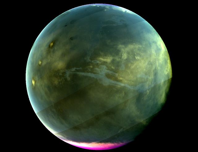
Caption: MAVEN's Imaging UltraViolet Spectrograph obtained this image of Mars on July 13, 2016, when the planet appeared nearly full when viewed from the highest altitudes in the MAVEN orbit. The ultraviolet colors of the planet have been rendered in false color, to show what we would see with ultraviolet-sensitive eyes. The ultraviolet (UV) view gives several new perspectives on Mars. Valles Marineris, a two-thousand-mile canyon system, appears prominently across the middle of the image as a blue gash. The deep canyon appears blue due to the scattering of ultraviolet light by the atmosphere, so strong that we cannot make out the bottom of the canyon. The greenish cast of the planet as a whole is a combination of the reflection of the surface plus the atmospheric scattering. The three tall Tharsis volcanoes appear near the left edge, dotted by white clouds forming as the winds flow over them. Bright white polar caps appear at both poles, typical for this season, in which there is a transition from southern-hemisphere winter to summer. The magenta-colored region visible at the south pole shows where ozone is absorbing ultraviolet light — the same property of ozone that protects life on Earth from harmful UV radiation. While ozone tends to be destroyed by chemical processes in the winter on Earth, different atmospheric chemistry at Mars caused it to build up in the winter there. A hint of ozone is also visible near the north pole; more will accumulate there as winter is coming. IUVS obtains images of Mars every orbit when the sunlit portion of the planet is visible from high altitude. Credits: NASA/Goddard/University of Colorado/LASP Read more: <a href="http://go.nasa.gov/2d9aU1N" rel="nofollow">go.nasa.gov/2d9aU1N</a> Today, NASA’s Mars Atmosphere and Volatile EvolutioN (MAVEN) mission completed one Mars year of science observations. One Mars year is just under two Earth years. MAVEN launched on Nov. 18, 2013, and went into orbit around Mars on Sept. 21, 2014. During its time at Mars, MAVEN has answered many questions about the Red Planet. “Taken together, the MAVEN results tell us that loss of gas from the atmosphere to space has been the major force behind the climate having changed from a warm, wet environment to the cold, dry one that we see today,” said Bruce Jakosky, MAVEN principal investigator, from the University of Colorado in Boulder. NASA recently declared that MAVEN had achieved mission success during its primary mission. Mission success means that the spacecraft operated as intended, made the expected science measurements, and achieved its proposed science objectives. <b><a href="http://www.nasa.gov/audience/formedia/features/MP_Photo_Guidelines.html" rel="nofollow">NASA image use policy.</a></b> <b><a href="http://www.nasa.gov/centers/goddard/home/index.html" rel="nofollow">NASA Goddard Space Flight Center</a></b> enables NASA’s mission through four scientific endeavors: Earth Science, Heliophysics, Solar System Exploration, and Astrophysics. Goddard plays a leading role in NASA’s accomplishments by contributing compelling scientific knowledge to advance the Agency’s mission. <b>Follow us on <a href="http://twitter.com/NASAGoddardPix" rel="nofollow">Twitter</a></b> <b>Like us on <a href="http://www.facebook.com/pages/Greenbelt-MD/NASA-Goddard/395013845897?ref=tsd" rel="nofollow">Facebook</a></b> <b>Find us on <a href="http://instagrid.me/nasagoddard/?vm=grid" rel="nofollow">Instagram</a></b>
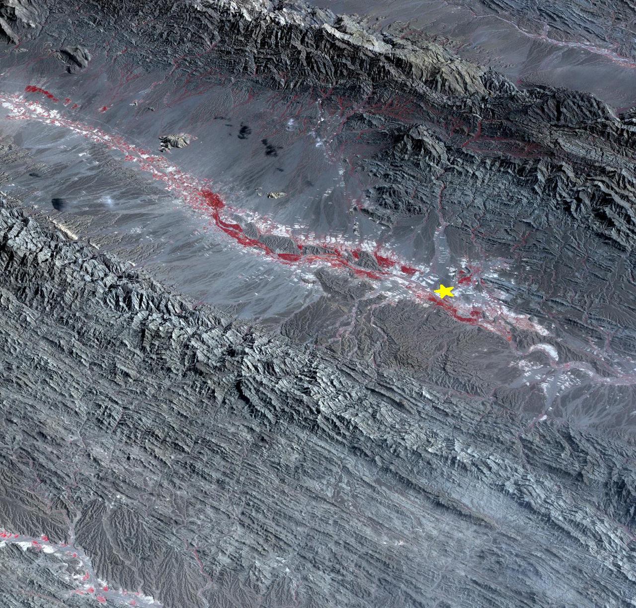
On September 24 at 11:29 GMT, a magnitude 7.7 earthquake struck in south-central Pakistan at a relatively shallow depth of 20 kilometers. The earthquake occurred as the result of oblique strike-slip motion, consistent with rupture within the Eurasian tectonic plate. Tremors were felt as far away as New Delhi as well as Karachi in Pakistan. Even though the immediate area to the epicenter is sparsely populated, the majority of houses are of mud brick construction and damage is expected to be extensive. The perspective view, looking to the east, shows the location of the epicenter in Pakistan's Makran fold belt. The image is centered near 27 degrees north latitude, 65.5 degrees east longitude, and was acquired December 13, 2012. With its 14 spectral bands from the visible to the thermal infrared wavelength region and its high spatial resolution of 15 to 90 meters (about 50 to 300 feet), ASTER images Earth to map and monitor the changing surface of our planet. ASTER is one of five Earth-observing instruments launched Dec. 18, 1999, on Terra. The instrument was built by Japan's Ministry of Economy, Trade and Industry. A joint U.S./Japan science team is responsible for validation and calibration of the instrument and data products. The broad spectral coverage and high spectral resolution of ASTER provides scientists in numerous disciplines with critical information for surface mapping and monitoring of dynamic conditions and temporal change. Example applications are: monitoring glacial advances and retreats; monitoring potentially active volcanoes; identifying crop stress; determining cloud morphology and physical properties; wetlands evaluation; thermal pollution monitoring; coral reef degradation; surface temperature mapping of soils and geology; and measuring surface heat balance. The U.S. science team is located at NASA's Jet Propulsion Laboratory, Pasadena, Calif. The Terra mission is part of NASA's Science Mission Directorate, Washington, D.C. More information about ASTER is available at <a href="http://asterweb.jpl.nasa.gov/" rel="nofollow">asterweb.jpl.nasa.gov/</a>. Image Credit: NASA/GSFC/METI/ERSDAC/JAROS, and U.S./Japan ASTER Science Team Image Addition Date: 2013-09-24 <b><a href="http://www.nasa.gov/audience/formedia/features/MP_Photo_Guidelines.html" rel="nofollow">NASA image use policy.</a></b> <b><a href="http://www.nasa.gov/centers/goddard/home/index.html" rel="nofollow">NASA Goddard Space Flight Center</a></b> enables NASA’s mission through four scientific endeavors: Earth Science, Heliophysics, Solar System Exploration, and Astrophysics. Goddard plays a leading role in NASA’s accomplishments by contributing compelling scientific knowledge to advance the Agency’s mission. <b>Follow us on <a href="http://twitter.com/NASA_GoddardPix" rel="nofollow">Twitter</a></b> <b>Like us on <a href="http://www.facebook.com/pages/Greenbelt-MD/NASA-Goddard/395013845897?ref=tsd" rel="nofollow">Facebook</a></b> <b>Find us on <a href="http://instagram.com/nasagoddard?vm=grid" rel="nofollow">Instagram</a></b>
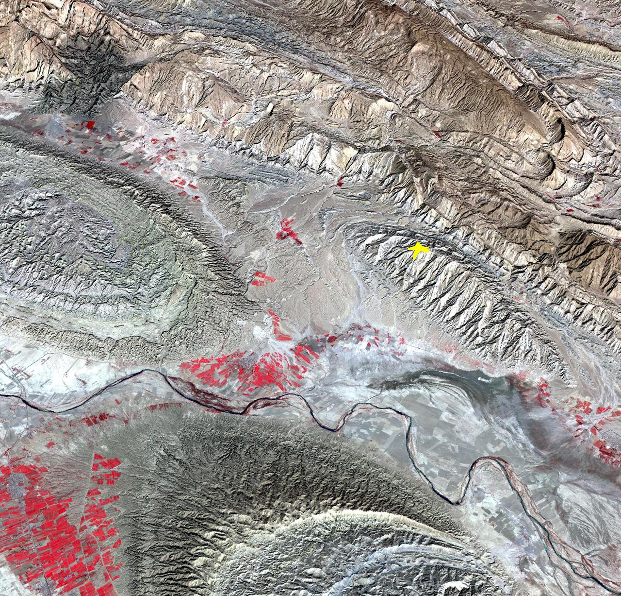
On April 9, 2013 at 11:52 GMT, a magnitude 6.3 earthquake hit southwestern Iran's Bushehr province near the town of Kaki. Preliminary information is that several villages have been destroyed and many people have died, as reported by BBC News. This perspective view of the region was acquired Nov. 17, 2012, by the Advanced Spaceborne Thermal Emission and Reflection Radiometer (ASTER) instrument on NASA's Terra spacecraft. The location of the earthquake's epicenter is marked with a yellow star. Vegetation is displayed in red; the vertical exaggeration of the topography is 2X. The image is centered near 28.5 degrees north latitude, 51.6 degrees east longitude. With its 14 spectral bands from the visible to the thermal infrared wavelength region and its high spatial resolution of 15 to 90 meters (about 50 to 300 feet), ASTER images Earth to map and monitor the changing surface of our planet. ASTER is one of five Earth-observing instruments launched Dec. 18, 1999, on Terra. The instrument was built by Japan's Ministry of Economy, Trade and Industry. A joint U.S./Japan science team is responsible for validation and calibration of the instrument and data products. The broad spectral coverage and high spectral resolution of ASTER provides scientists in numerous disciplines with critical information for surface mapping and monitoring of dynamic conditions and temporal change. Example applications are: monitoring glacial advances and retreats; monitoring potentially active volcanoes; identifying crop stress; determining cloud morphology and physical properties; wetlands evaluation; thermal pollution monitoring; coral reef degradation; surface temperature mapping of soils and geology; and measuring surface heat balance. The U.S. science team is located at NASA's Jet Propulsion Laboratory, Pasadena, Calif. The Terra mission is part of NASA's Science Mission Directorate, Washington, D.C. More information about ASTER is available at <a href="http://asterweb.jpl.nasa.gov/" rel="nofollow">asterweb.jpl.nasa.gov/</a>. Image Credit: NASA/GSFC/METI/ERSDAC/JAROS, and U.S./Japan ASTER Science Team Image Addition Date: 2013-04-10 <b><a href="http://www.nasa.gov/audience/formedia/features/MP_Photo_Guidelines.html" rel="nofollow">NASA image use policy.</a></b> <b><a href="http://www.nasa.gov/centers/goddard/home/index.html" rel="nofollow">NASA Goddard Space Flight Center</a></b> enables NASA’s mission through four scientific endeavors: Earth Science, Heliophysics, Solar System Exploration, and Astrophysics. Goddard plays a leading role in NASA’s accomplishments by contributing compelling scientific knowledge to advance the Agency’s mission. <b>Follow us on <a href="http://twitter.com/NASA_GoddardPix" rel="nofollow">Twitter</a></b> <b>Like us on <a href="http://www.facebook.com/pages/Greenbelt-MD/NASA-Goddard/395013845897?ref=tsd" rel="nofollow">Facebook</a></b> <b>Find us on <a href="http://instagram.com/nasagoddard?vm=grid" rel="nofollow">Instagram</a></b>