
NASA CTO Douglas Terrier is interviewed by NBC's Tom Costello during an Eclipse Across America broadcast aboard the USS Yorktown in Charleston, South Carolina on Aug. 21, 2017.

NASA CTO Douglas Terrier talks with the "Today Show's" Al Roker about NASA's science research during an Eclipse Across America broadcast aboard the USS Yorktown in Charleston, South Carolina on Aug. 21, 2017.

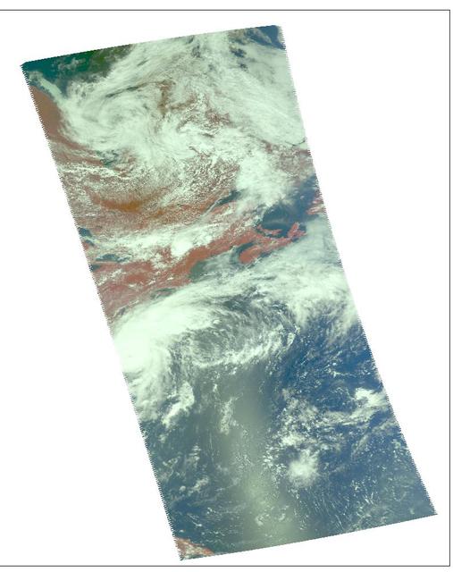
Damaging heavy rains fell on South Carolina in the southeastern United States at the beginning of October 2015. Much of that water had, by mid October, flowed into the Atlantic Ocean bringing with it heavy loads of sediment, nutrients, and dissolved organic material. The above VIIRS image shows the runoff as it interacts with ocean currents on October 15, 2015. Credit: NASA/Goddard/SuomiNPP/VIIRS via NASA's OceanColor
These images of hurricane Alex were captured on August 3, 2004 at 1:30pm EDT. Located in the Atlantic Ocean located about 80 miles south-southeast of Charleston, South Carolina, Alex is now a category 2 hurricane with maximum sustained winds were near 100 mph (161 kph). Alex's center was about 65 miles (104 kilometers) northeast of Cape Hatteras and moving away from the U.S. coast. http://photojournal.jpl.nasa.gov/catalog/PIA00440

Charleston is the largest city in South Carolina, with almost 1 million people. It was founded in 1670 by the English. By 1690, it was the 5th largest city in North America. The 1699 earthquake and fire destroyed 1/3 of town. Malaria and yellow fever were endemic. The location attracted pirates. In 1860, South Carolina became the first state to declare secession from US. In 1886 a major earthquake damaged 2000 bldgs. More recently, in 1989 Hurricane Hugo devastated ¾ of homes in the historic district. The image was acquired August 15, 2023, covers an area of 18.1 by 18.6 km, and is located at 32.8 degrees north, 79.9 degrees west. https://photojournal.jpl.nasa.gov/catalog/PIA26507

AS09-26A-3793A (12 March 1969) --- Color infrared photograph of the Atlantic Coast of South Carolina, Georgetown-Myrtle Beach-Conway area, taken on March 12, 1969, by one of the four synchronized cameras of the Apollo 9 Earth Resources Survey SO65 Experiment. At 10:00 a.m. (EST) when this picture was made the Apollo 9 spacecraft was at an altitude of 116 nautical miles, and the sun elevation was 39 degrees above the horizon. The location of the point on Earth's surface at which the four-camera combination was aimed was 33 degrees 35 minutes north latitude, and 79 degrees 3 minutes west longitude. The other three cameras used: (B) black and white film with a red filter; (C) black and white infrared film; and (D) black and white film with a green filter.

On Sept. 5, 2019 at about noon EDT, the Multi-angle Imaging SpectroRadiometer (MISR) instrument aboard NASA's Terra satellite passed over the eye of Hurricane Dorian as the storm tracked northeast along the Atlantic coast, about 50 miles from Charleston, South Carolina. During this time, Dorian was weakening from Category 3 to Category 2 following a second period of intensification. MISR carries nine cameras fixed at different angles, each of which viewed Dorian over a period of about seven minutes. The multi-camera views are used to calculate the heights of the cloud tops, and the motion of the clouds between the views provides information on wind speed and direction. The left side of the image shows the view from the downward-pointing (nadir) camera, with wind velocity vectors superimposed over it. The derived cloud-top heights are shown at the right, along with the color scale. The length of the wind arrows is proportional to wind speed and their colors show the altitude of the cloud tops in kilometers. MISR observed cyclonic (counterclockwise) wind speeds up to 35 meters per second (78 miles per hour) at altitudes of 3-4 kilometers (1.9 to 2.5 miles), consistent with maximal wind gusts reported by the National Hurricane Center based on data from local weather stations and buoys. At higher altitudes of 11-12 kms (6.8-7.5 miles), MISR observed anti-cyclonic (clockwise) wind speeds up to 55 meters per second (123 mph). The eye, spiral rainbands, and reversal of wind direction between low and high altitudes are typical features of a hurricane's anatomy. https://photojournal.jpl.nasa.gov/catalog/PIA23423
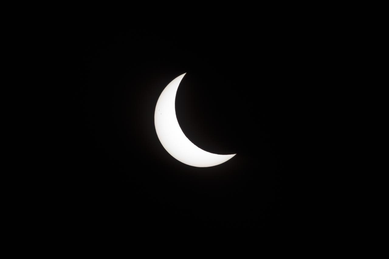
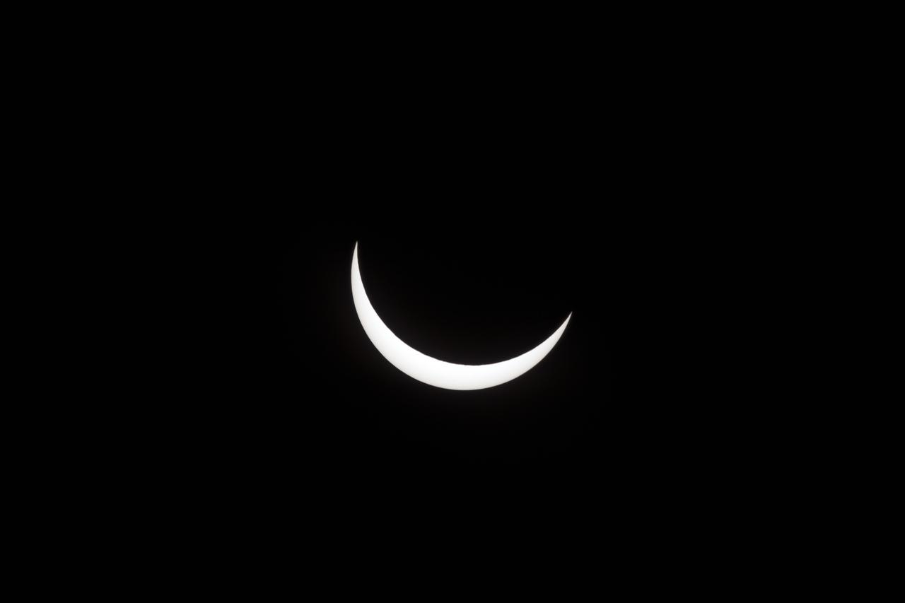
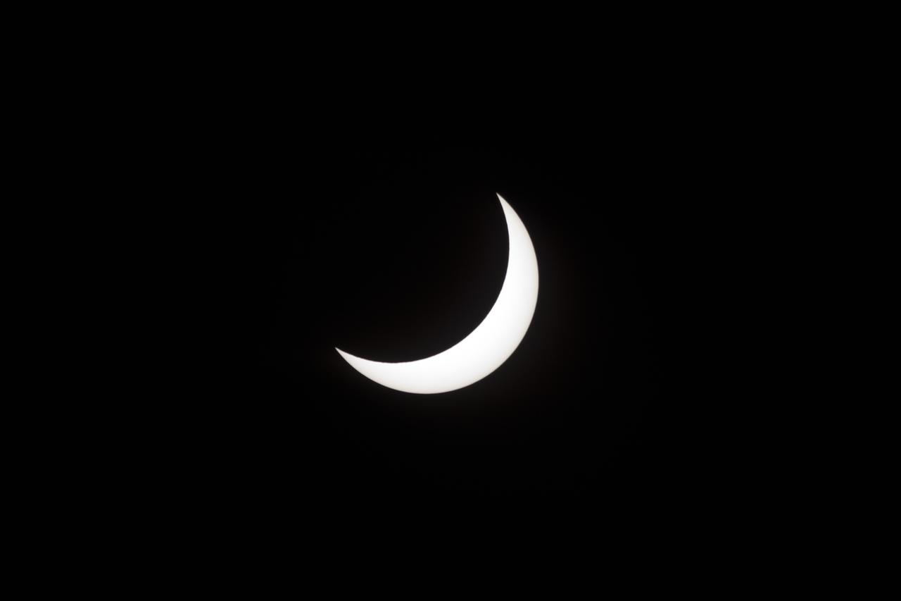
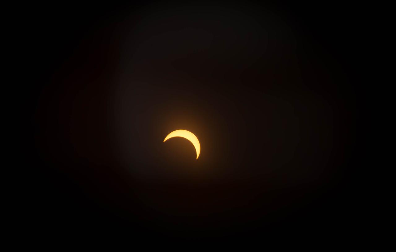
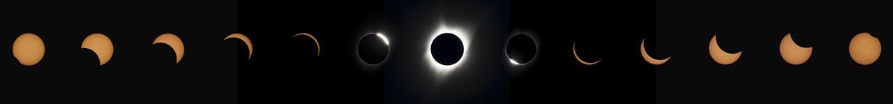
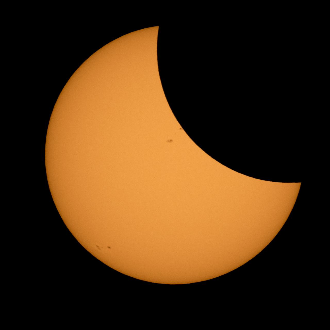
A partial eclipse on Florida's Space Coast, the rare astronomical event was photographed from the top of the Vehicle Assembly Building, as the Moon passed between Earth and the midafternoon Sun. The Moon's shadow moved across the landscape from Oregon to South Carolina. The 70-mile-wide totality path, or "umbral cone" -- where the entire Sun will vanish behind the Moon -- stretched across 14 states, from Oregon to South Carolina.
A partial eclipse on Florida's Space Coast, the rare astronomical event was photographed from the top of the Vehicle Assembly Building, as the Moon passed between Earth and the midafternoon Sun. The Moon's shadow moved across the landscape from Oregon to South Carolina. The 70-mile-wide totality path, or "umbral cone" -- where the entire Sun will vanish behind the Moon -- stretched across 14 states, from Oregon to South Carolina.
A partial eclipse on Florida's Space Coast, the rare astronomical event was photographed from the top of the Vehicle Assembly Building, as the Moon passed between Earth and the midafternoon Sun. The Moon's shadow moved across the landscape from Oregon to South Carolina. The 70-mile-wide totality path, or "umbral cone" -- where the entire Sun will vanish behind the Moon -- stretched across 14 states, from Oregon to South Carolina.
A partial eclipse on Florida's Space Coast, the rare astronomical event was photographed from the top of the Vehicle Assembly Building, as the Moon passed between Earth and the midafternoon Sun. The Moon's shadow moved across the landscape from Oregon to South Carolina. The 70-mile-wide totality path, or "umbral cone" -- where the entire Sun will vanish behind the Moon -- stretched across 14 states, from Oregon to South Carolina.
A partial eclipse on Florida's Space Coast, the rare astronomical event was photographed from the top of the Vehicle Assembly Building, as the Moon passed between Earth and the midafternoon Sun. The Moon's shadow moved across the landscape from Oregon to South Carolina. The 70-mile-wide totality path, or "umbral cone" -- where the entire Sun will vanish behind the Moon -- stretched across 14 states, from Oregon to South Carolina.
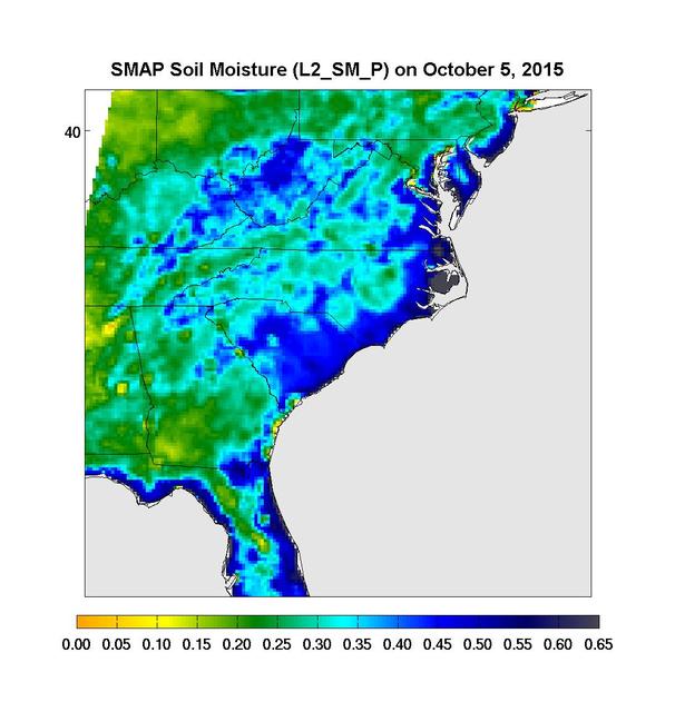
Surface soil moisture in the Southeastern United States as retrieved from NASA's Soil Moisture Active Passive (SMAP) satellite observatory at around 6 a.m. on Oct. 5, 2015. Large parts of South Carolina appear blue, representing the impact of heavy localized rains and flooding. Regions in blue indicate areas with saturated soil conditions and possible standing water. Large-scale flooding was experienced all over South Carolina on Oct. 5-6, 2015. As of Oct. 7, 17 deaths had been attributed to these floods, with heavy economic losses. In some regions, the intensity of these floods was described as a 1,000-year storm (1-in-1,000 chance of happening in any given year). At least 14 dams have already failed as a result of these floods. http://photojournal.jpl.nasa.gov/catalog/PIA20001
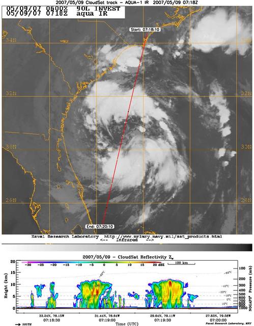
CloudSat's Cloud Profiling Radar captured a profile across Tropical Storm Andrea on Wednesday, May 9, 2007, near the South Carolina/Georgia/Florida Atlantic coast. The upper image shows an infrared view of Tropical Storm Andrea from the Moderate Resolution Imaging Spectroradiometer instrument on NASA's Aqua satellite, with CloudSat's ground track shown as a red line. The lower image is the vertical cross section of radar reflectivity along this path, where the colors indicate the intensity of the reflected radar energy. CloudSat orbits approximately one minute behind Aqua in a satellite formation known as the A-Train. http://photojournal.jpl.nasa.gov/catalog/PIA09379

iss070e043540 (Dec. 20, 2023) --- Charleston, South Carolina, and its sourrounding suburbs are split by rivers and creeks emptying into the Atlantic Ocean in this photograph from the International Space Station as it orbited 259 miles above.
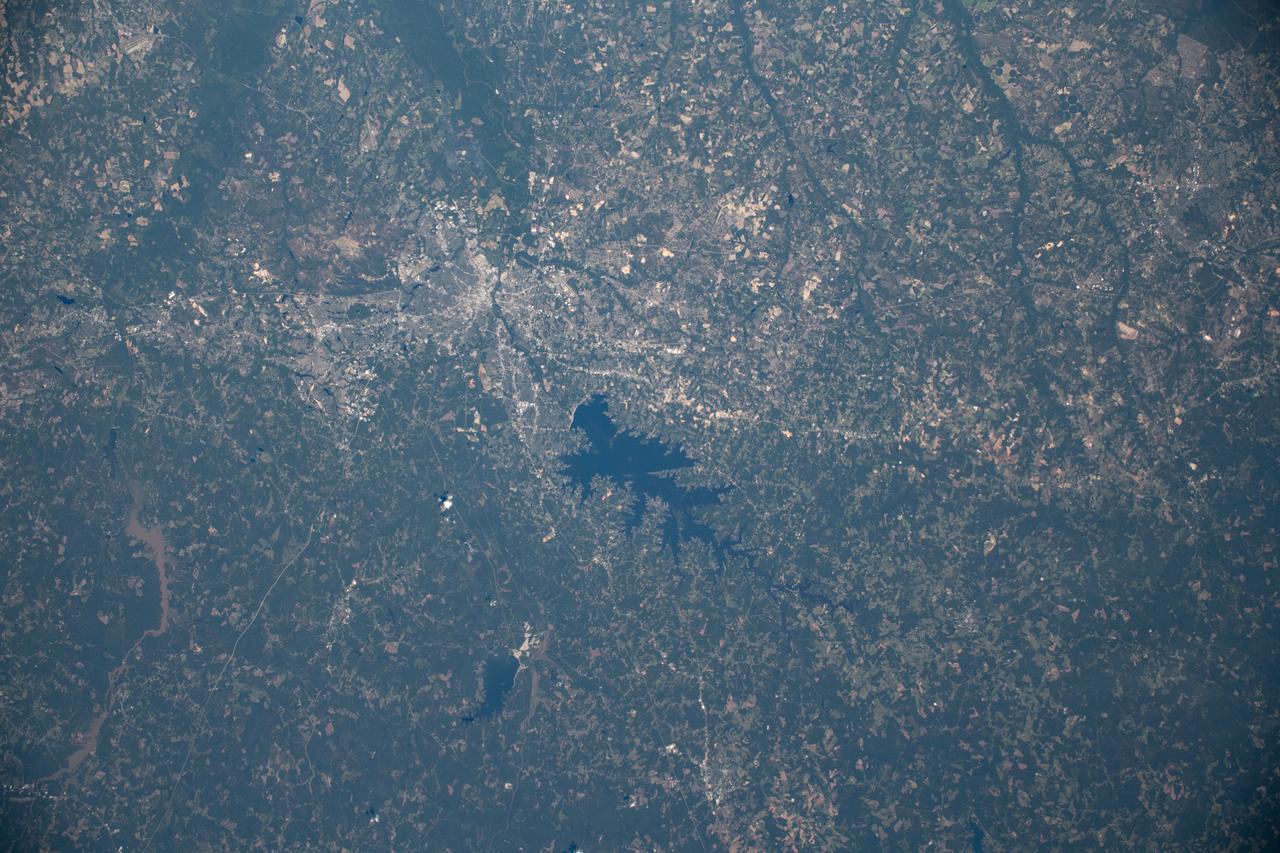
iss059e122299 (June 21, 2019) --- The Monticello Reservoir, Lake Murray and Columbia, South Carolina are pictured as the International Space Station orbited above the Atlantic Coastal Plain of the United States at an altitude of 256 miles.
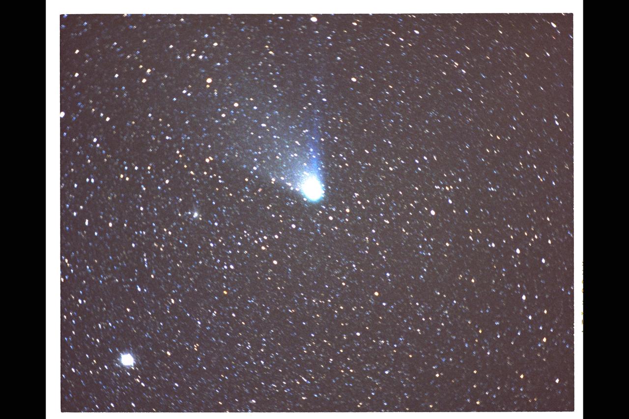
C-141 Kuiper Airborne Imagery of Comet Halley (New Zealand Expedition) PHOTO CREDIT Photo taken with equipment designed, mounted on the headring and operated by the Charleston (South Carolina) County School District CAN DO Project;

iss055e023210 (April 14, 2018) --- Chesapeake Bay, Delaware Bay and the east coast of the United States from South Carolina to Connecticut were pictured as the International Space Station orbited 250 miles above the Atlantic Ocean.

iss056e162187 (Sept. 12, 2018) --- Cameras outside the International Space Station captured a stark and sobering view of Hurricane Florence the morning of Sept. 12 as it churned across the Atlantic in a west-northwesterly direction with winds of 130 miles an hour. The National Hurricane Center forecasts additional strengthening for Florence before it reaches the coastline of North Carolina and South Carolina early Friday, Sept. 14.

iss056e162190 (Sept. 12, 2018) --- Cameras outside the International Space Station captured a stark and sobering view of Hurricane Florence the morning of Sept. 12 as it churned across the Atlantic in a west-northwesterly direction with winds of 130 miles an hour. The National Hurricane Center forecasts additional strengthening for Florence before it reaches the coastline of North Carolina and South Carolina early Friday, Sept. 14.

iss056e162202 (Sept. 12, 2018) --- Cameras outside the International Space Station captured a stark and sobering view of Hurricane Florence the morning of Sept. 12 as it churned across the Atlantic in a west-northwesterly direction with winds of 130 miles an hour. The National Hurricane Center forecasts additional strengthening for Florence before it reaches the coastline of North Carolina and South Carolina early Friday, Sept. 14.

ISS043E182257 (05/08/2015) --- Hurricane Anna moves onto the US east coast with 50 mile an hour winds and heavy rain. Anna moved first into just north of Myrtle Beach South Carolina and is moving toward North Carolina and later Virginia. This image was taken by the crew onboard the International Space Station, Expedition 43.

iss056e162175 (Sept. 12, 2018) --- Cameras outside the International Space Station captured a stark and sobering view of Hurricane Florence the morning of Sept. 12 as it churned across the Atlantic in a west-northwesterly direction with winds of 130 miles an hour. The National Hurricane Center forecasts additional strengthening for Florence before it reaches the coastline of North Carolina and South Carolina early Friday, Sept. 14.

iss056e162207 (Sept. 12, 2018) --- Cameras outside the International Space Station captured a stark and sobering view of Hurricane Florence the morning of Sept. 12 as it churned across the Atlantic in a west-northwesterly direction with winds of 130 miles an hour. The National Hurricane Center forecasts additional strengthening for Florence before it reaches the coastline of North Carolina and South Carolina early Friday, Sept. 14.

iss056e162178 (Sept. 12, 2018) --- Cameras outside the International Space Station captured a stark and sobering view of Hurricane Florence the morning of Sept. 12 as it churned across the Atlantic in a west-northwesterly direction with winds of 130 miles an hour. The National Hurricane Center forecasts additional strengthening for Florence before it reaches the coastline of North Carolina and South Carolina early Friday, Sept. 14.

KENNEDY SPACE CENTER, FLA. -- An immature -- therefore white -- Little Blue Heron (center, with black bill) joins Roseate Spoonbills and a pair of Great Egrets in a lake near Kennedy Space Center. The heron ranges along the east coast of the United States, from New York to Texas, inland to Oklahoma. It winters from South Carolina to South America. For habitat the Little Blue Heron prefers freshwater swamps and lagoons in the South, coastal thickets on islands in the North. The species is often observed in large mixed concentrations of herons and egrets

iss073e0149171 (May 21, 2025) --- City lights dot the southern United States' landscape from Louisiana (upper left), to Florida (lower center), to South Carolina (right), in this photograph from the International Space Station as it orbited 260 miles above Georgia at approximately 12:59 a.m. local time.
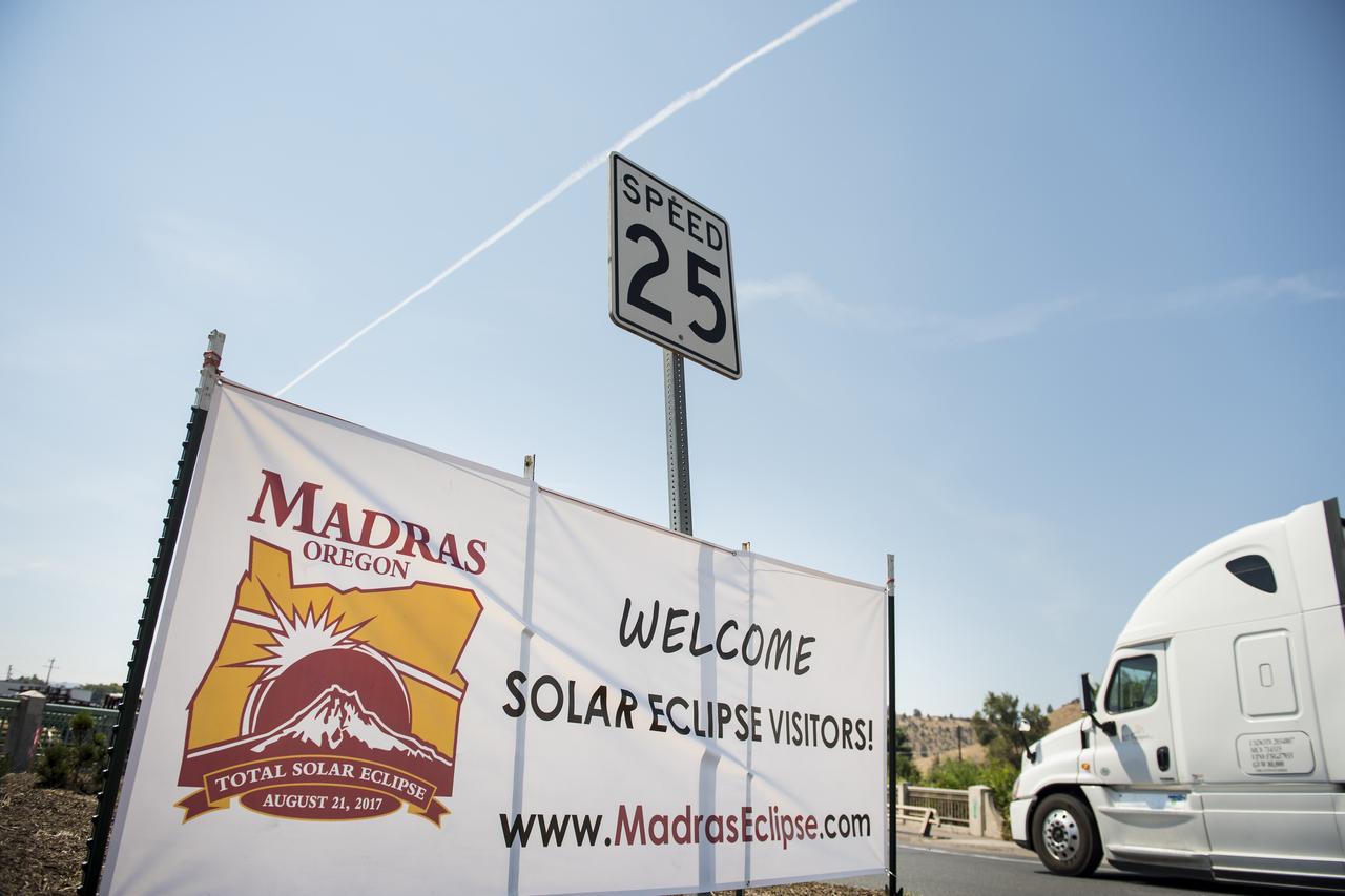
A welcome sign is seen along the roads in Madras, Oregon, where thousands of visitors are expected for the total solar eclipse, Saturday, August 19, 2017. The eclipse will be sweeping across a narrow portion of the contiguous United States from Lincoln Beach, Oregon to Charleston, South Carolina on August 21. A partial solar eclipse will be visible across the entire North American continent along with parts of South America, Africa, and Europe. Photo Credit: (NASA/Aubrey Gemignani)

A boy watches the total solar eclipse through protective glasses in Madras, Oregon on Monday, Aug. 21, 2017. A total solar eclipse swept across a narrow portion of the contiguous United States from Lincoln Beach, Oregon to Charleston, South Carolina. A partial solar eclipse was visible across the entire North American continent along with parts of South America, Africa, and Europe. Photo Credit: (NASA/Aubrey Gemignani)

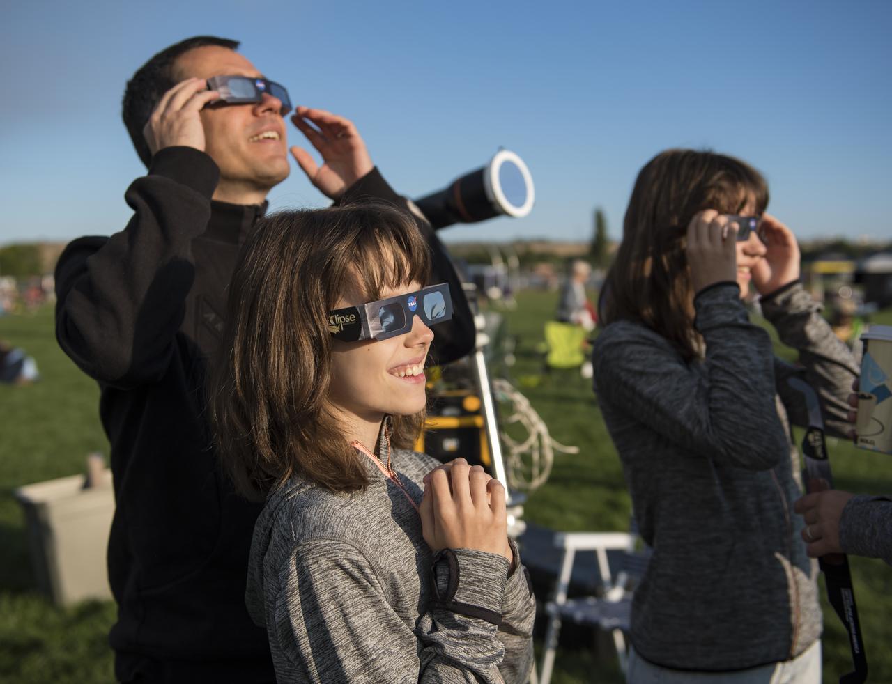
People are seen as they watch a total solar eclipse through protective glasses in Madras, Oregon on Monday, Aug. 21, 2017. A total solar eclipse swept across a narrow portion of the contiguous United States from Lincoln Beach, Oregon to Charleston, South Carolina. A partial solar eclipse was visible across the entire North American continent along with parts of South America, Africa, and Europe. Photo Credit: (NASA/Aubrey Gemignani)

People are seen as they watch a total solar eclipse through protective glasses in Madras, Oregon on Monday, Aug. 21, 2017. A total solar eclipse swept across a narrow portion of the contiguous United States from Lincoln Beach, Oregon to Charleston, South Carolina. A partial solar eclipse was visible across the entire North American continent along with parts of South America, Africa, and Europe. Photo Credit: (NASA/Aubrey Gemignani)
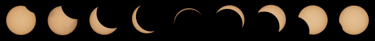
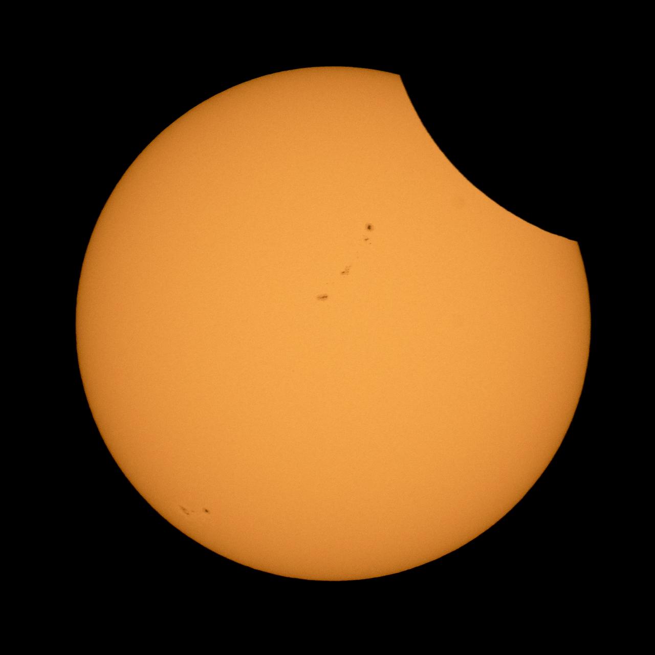
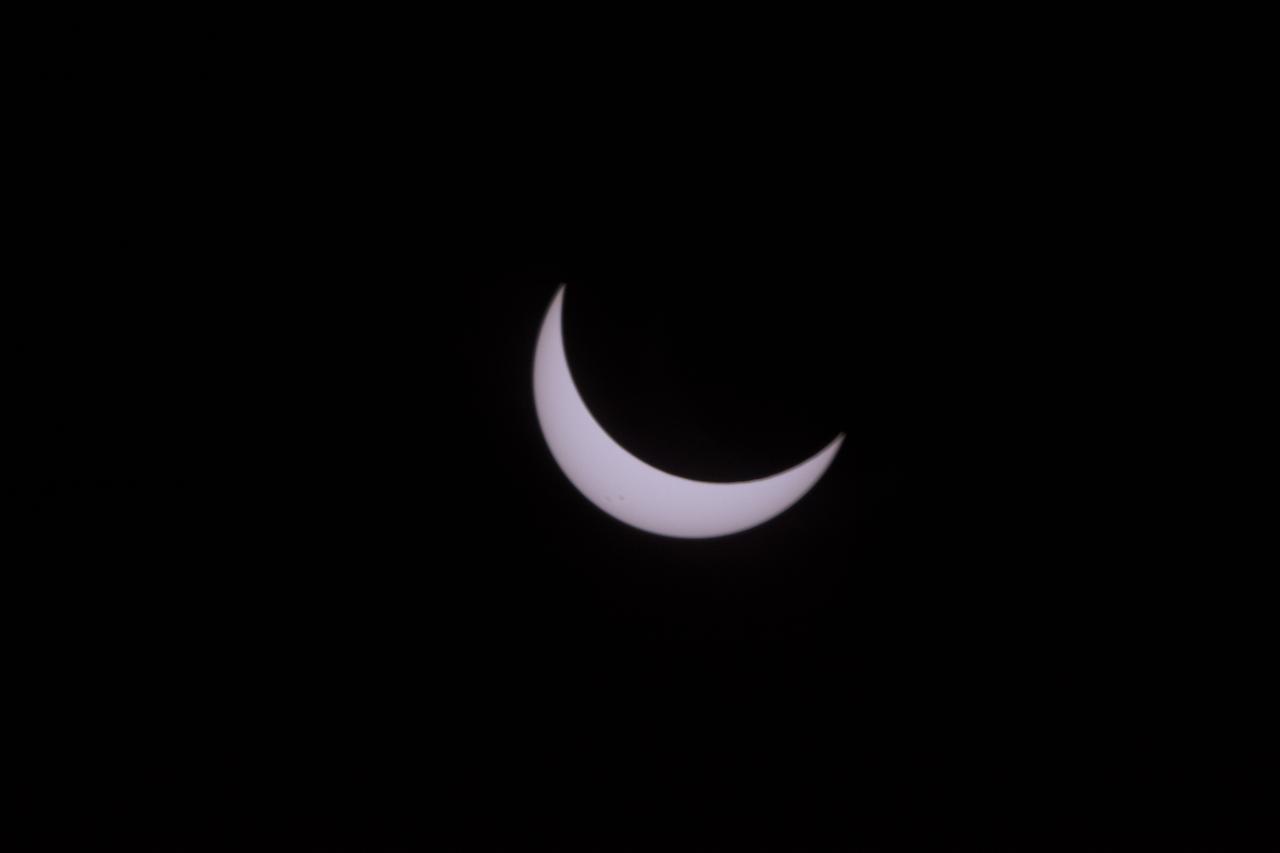
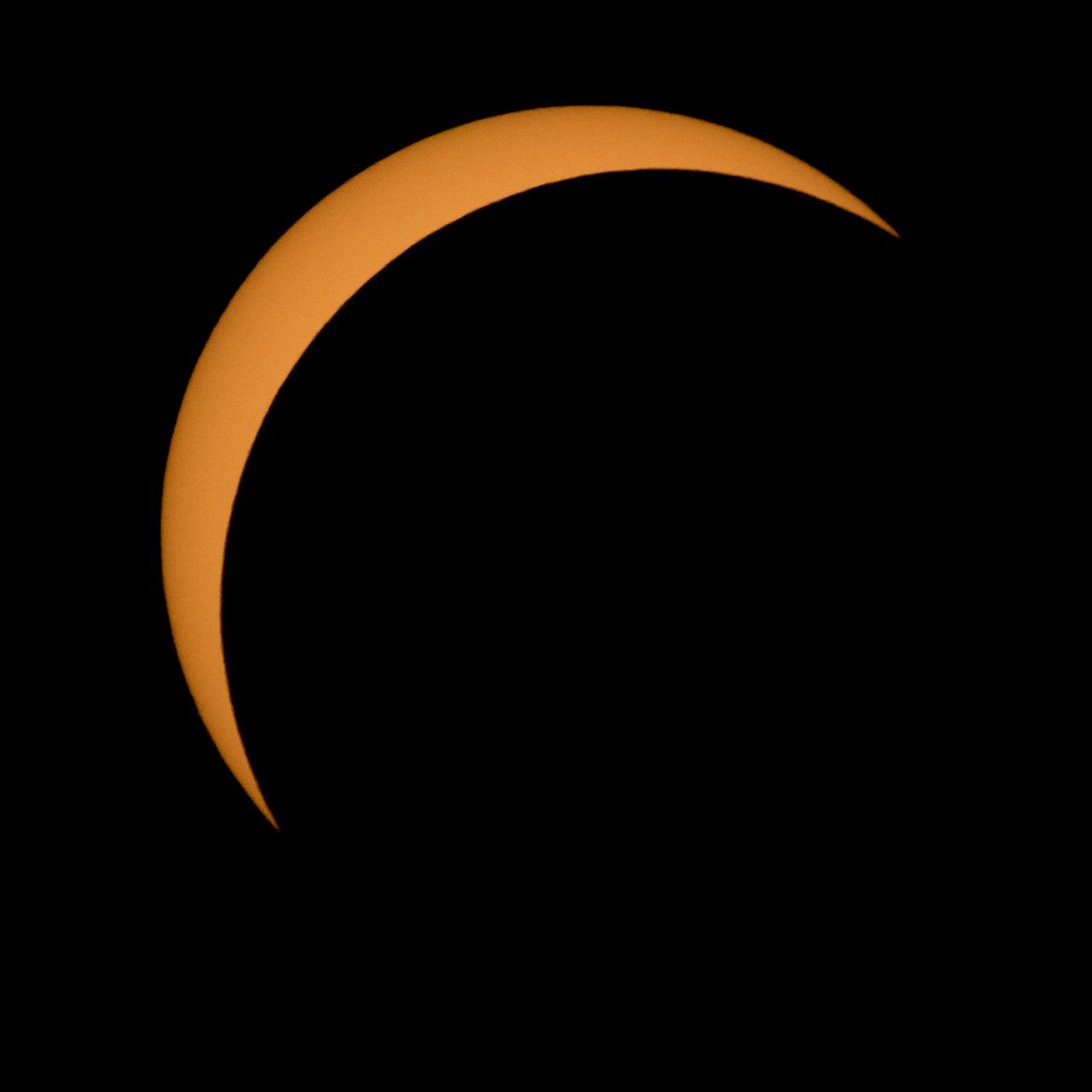
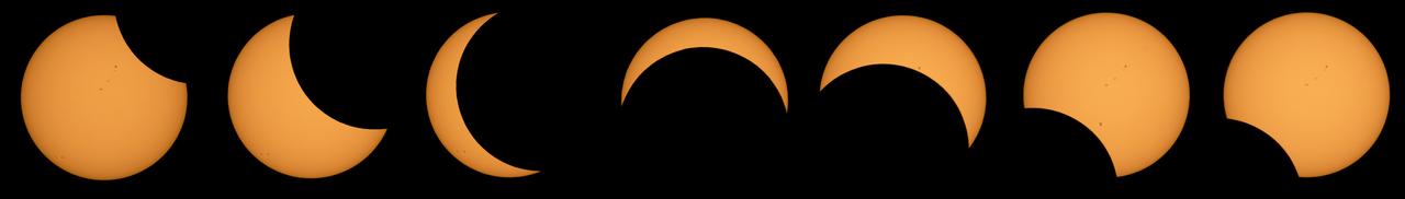
This composite image of nine pictures shows the progression of a partial solar eclipse near Banner, Wyoming on Monday, Aug. 21, 2017. A total solar eclipse swept across a narrow portion of the contiguous United States from Lincoln Beach, Oregon to Charleston, South Carolina. A partial solar eclipse was visible across the entire North American continent along with parts of South America, Africa, and Europe. Photo Credit: (NASA/Joel Kowsky)
View of the partial solar eclipse from NASA's Goddard Space Flight Center in Greenbelt, Md on Monday, August 21, 2017. A total solar eclipse swept across a narrow portion of the contiguous United States from Lincoln Beach, Oregon to Charleston, South Carolina. A partial solar eclipse was visible across the entire North American continent along with parts of South America, Africa, and Europe. Credit: NASA/Goddard/Rebecca Roth
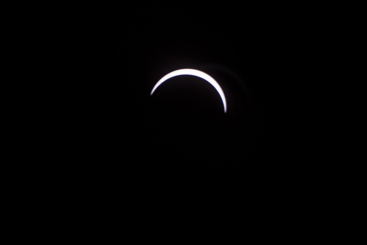
The Moon is seen as it starts passing in front of the Sun during a solar eclipse from Ross Lake, Northern Cascades National Park, Washington on Monday, Aug. 21, 2017. A total solar eclipse swept across a narrow portion of the contiguous United States from Lincoln Beach, Oregon to Charleston, South Carolina. A partial solar eclipse was visible across the entire North American continent along with parts of South America, Africa, and Europe. Photo Credit: (NASA/Bill Ingalls)

NASA employees and contractors use protective glasses to view a partial solar eclipse from NASA Headquarters Tuesday, Aug. 22, 2017 in Washington. A total solar eclipse swept across a narrow portion of the contiguous United States from Lincoln Beach, Oregon to Charleston, South Carolina. A partial solar eclipse was visible across the entire North American continent along with parts of South America, Africa, and Europe. Photo Credit: (NASA/Gwen Pitman)
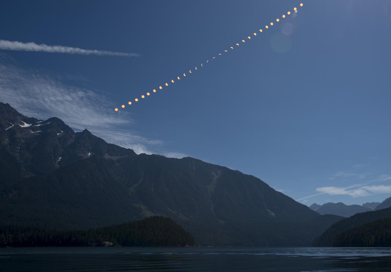
This composite image shows the progression of a partial solar eclipse over Ross Lake, in Northern Cascades National Park, Washington on Monday, Aug. 21, 2017. A total solar eclipse swept across a narrow portion of the contiguous United States from Lincoln Beach, Oregon to Charleston, South Carolina. A partial solar eclipse was visible across the entire North American continent along with parts of South America, Africa, and Europe. Photo Credit: (NASA/Bill Ingalls)

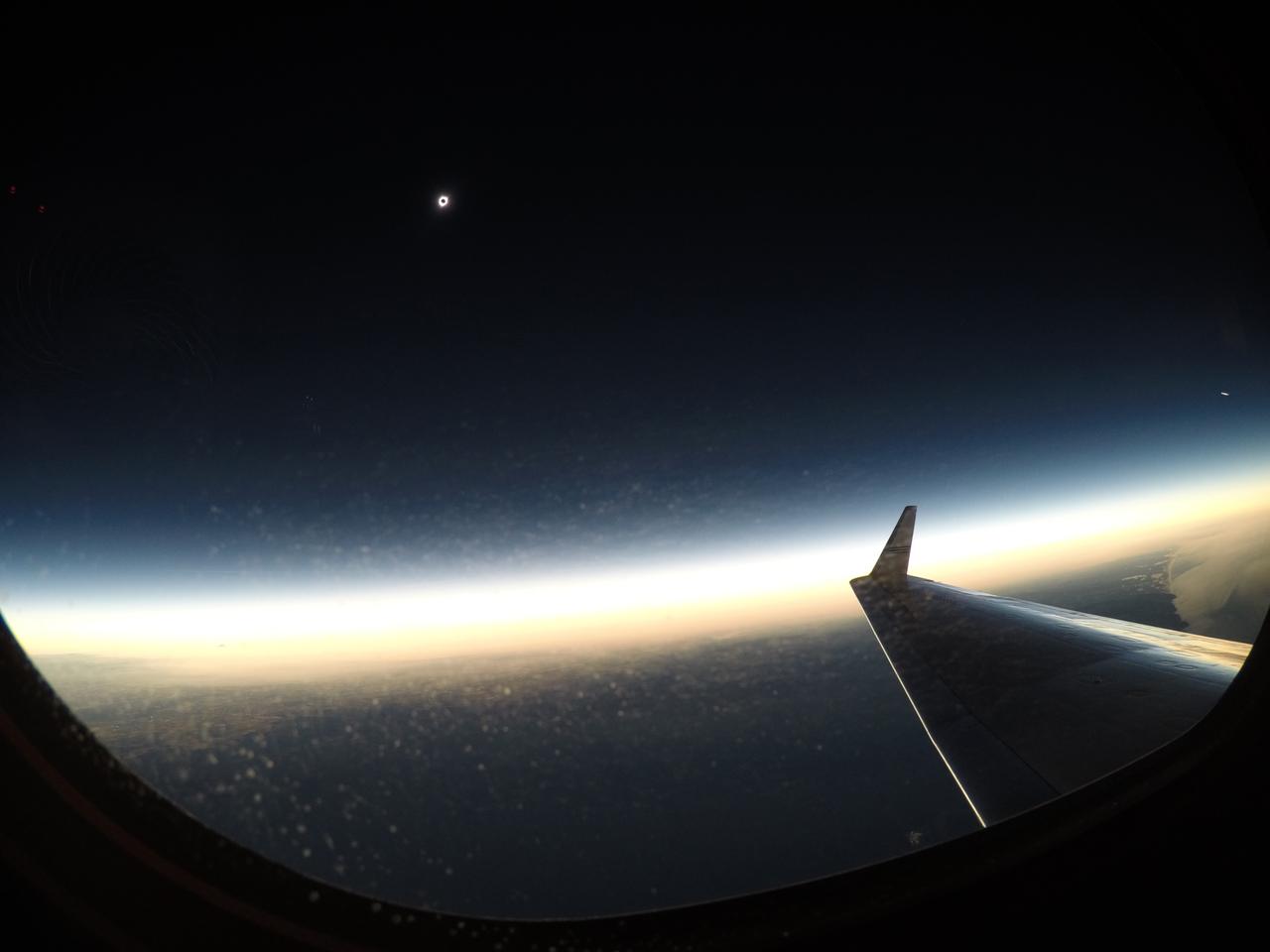
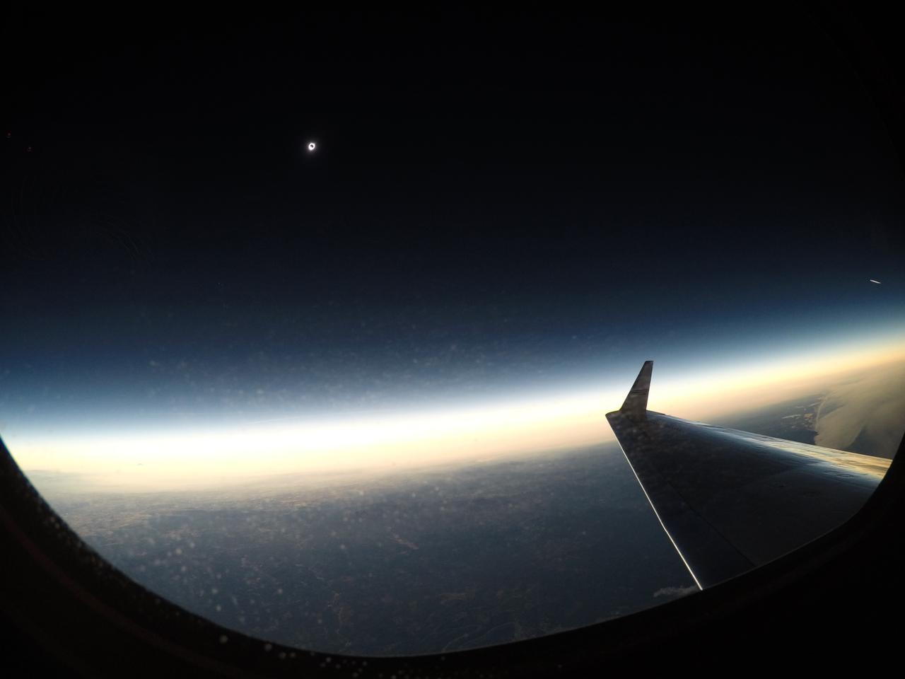
The Moon is seen passing in front of the Sun during a total solar eclipse on Monday, August 21, 2017 from onboard a NASA Gulfstream III aircraft flying 25,000 feet above the Oregon coast. A total solar eclipse swept across a narrow portion of the contiguous United States from Lincoln Beach, Oregon to Charleston, South Carolina. A partial solar eclipse was visible across the entire North American continent along with parts of South America, Africa, and Europe. Photo Credit: (NASA/Carla Thomas)

People are seen as they watch a total solar eclipse through protective glasses in Madras, Oregon on Monday, Aug. 21, 2017. A total solar eclipse swept across a narrow portion of the contiguous United States from Lincoln Beach, Oregon to Charleston, South Carolina. A partial solar eclipse was visible across the entire North American continent along with parts of South America, Africa, and Europe. Photo Credit: (NASA/Aubrey Gemignani)

Dave Punaro reflects the shadow of the partial eclipse into a box during the total solar eclipse in Madras, Oregon on Monday, Aug. 21, 2017. A total solar eclipse swept across a narrow portion of the contiguous United States from Lincoln Beach, Oregon to Charleston, South Carolina. A partial solar eclipse was visible across the entire North American continent along with parts of South America, Africa, and Europe. Photo Credit: (NASA/Aubrey Gemignani)
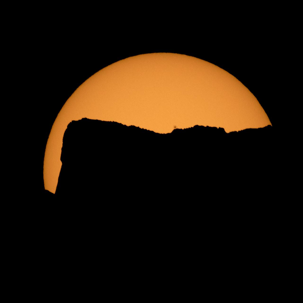
The Sun is seen as it rises behind Jack Mountain head of the solar eclipse, Monday, Aug. 21, 2017, Ross Lake, Northern Cascades National Park, Washington. A total solar eclipse will sweep across a narrow portion of the contiguous United States from Lincoln Beach, Oregon to Charleston, South Carolina. A partial solar eclipse was visible across the entire North American continent along with parts of South America, Africa, and Europe. Photo Credit: (NASA/Bill Ingalls)

Eirik Olsen, of Seattle, Washington, plays giant Jenga while waiting to watch the total solar eclipse in Madras, Oregon on Saturday, August 19, 2017. The eclipse will be sweeping across a narrow portion of the contiguous United States from Lincoln Beach, Oregon to Charleston, South Carolina on August 21. A partial solar eclipse will be visible across the entire North American continent along with parts of South America, Africa, and Europe. Photo Credit: (NASA/Aubrey Gemignani)
The Moon is seen passing in front of the Sun during a total solar eclipse on Monday, August 21, 2017 from onboard a NASA Gulfstream III aircraft flying 25,000 feet above the Oregon coast. A total solar eclipse swept across a narrow portion of the contiguous United States from Lincoln Beach, Oregon to Charleston, South Carolina. A partial solar eclipse was visible across the entire North American continent along with parts of South America, Africa, and Europe. Photo Credit: (NASA/Carla Thomas)
The Moon is seen passing in front of the Sun during a solar eclipse from Ross Lake, Northern Cascades National Park, Washington on Monday, Aug. 21, 2017. A total solar eclipse swept across a narrow portion of the contiguous United States from Lincoln Beach, Oregon to Charleston, South Carolina. A partial solar eclipse was visible across the entire North American continent along with parts of South America, Africa, and Europe. Photo Credit: (NASA/Bill Ingalls)
The Moon is seen passing in front of the Sun during a total solar eclipse on Monday, August 21, 2017 from onboard a NASA Gulfstream III aircraft flying 25,000 feet above the Oregon coast. A total solar eclipse swept across a narrow portion of the contiguous United States from Lincoln Beach, Oregon to Charleston, South Carolina. A partial solar eclipse was visible across the entire North American continent along with parts of South America, Africa, and Europe. Photo Credit: (NASA/Carla Thomas)
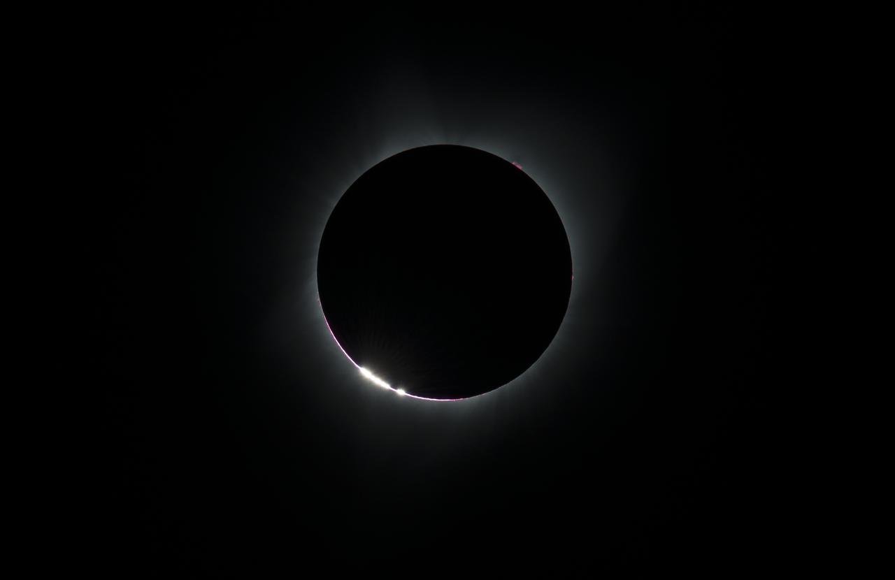
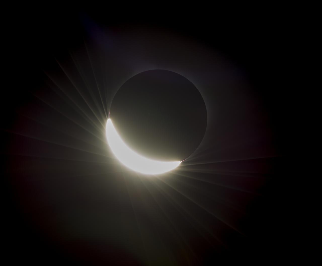
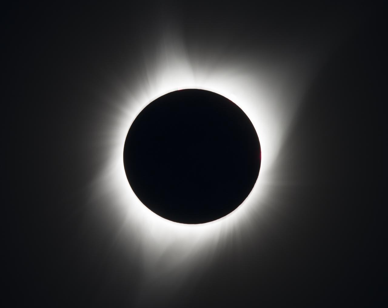
The Baily's Beads effect is seen as the moon makes its final move over the sun during the total solar eclipse on Monday, August 21, 2017 above Madras, Oregon. A total solar eclipse swept across a narrow portion of the contiguous United States from Lincoln Beach, Oregon to Charleston, South Carolina. A partial solar eclipse was visible across the entire North American continent along with parts of South America, Africa, and Europe. Photo Credit: (NASA/Aubrey Gemignani)
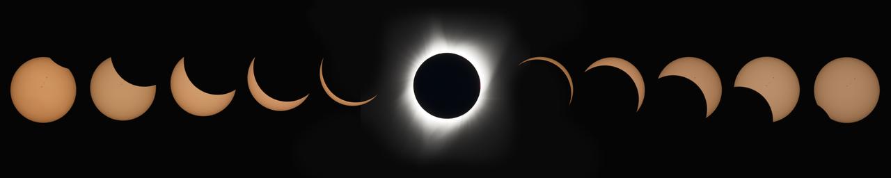
This composite image of thirteen photographs shows the progression of a total solar eclipse at Madras High School in Madras, Oregon on Monday, August 21, 2017. A total solar eclipse swept across a narrow portion of the contiguous United States from Lincoln Beach, Oregon to Charleston, South Carolina. A partial solar eclipse was visible across the entire North American continent along with parts of South America, Africa, and Europe. Photo Credit: (NASA/Aubrey Gemignani)
The Moon is seen passing in front of the Sun during a total solar eclipse on Monday, August 21, 2017 from onboard a NASA Gulfstream III aircraft flying 25,000 feet above the Oregon coast. A total solar eclipse swept across a narrow portion of the contiguous United States from Lincoln Beach, Oregon to Charleston, South Carolina. A partial solar eclipse was visible across the entire North American continent along with parts of South America, Africa, and Europe. Photo Credit: (NASA/Carla Thomas)
A total solar eclipse is seen on Monday, Aug. 21, 2017 above Madras, Oregon. A total solar eclipse swept across a narrow portion of the contiguous United States from Lincoln Beach, Oregon to Charleston, South Carolina. A partial solar eclipse was visible across the entire North American continent along with parts of South America, Africa, and Europe. Photo Credit: (NASA/Aubrey Gemignani)
The last glimmer of the sun is seen as the moon makes its final move over the sun during the total solar eclipse on Monday, August 21, 2017 above Madras, Oregon. A total solar eclipse swept across a narrow portion of the contiguous United States from Lincoln Beach, Oregon to Charleston, South Carolina. A partial solar eclipse was visible across the entire North American continent along with parts of South America, Africa, and Europe. Photo Credit: (NASA/Aubrey Gemignani)
Klaus Koschinsky, left, and his daughters, Claudia, center, and Tanja, right, from Munich, Germany, are seen as they watch a total solar eclipse through protective glasses in Madras, Oregon on Monday, Aug. 21, 2017. A total solar eclipse swept across a narrow portion of the contiguous United States from Lincoln Beach, Oregon to Charleston, South Carolina. A partial solar eclipse was visible across the entire North American continent along with parts of South America, Africa, and Europe. Photo Credit: (NASA/Aubrey Gemignani)
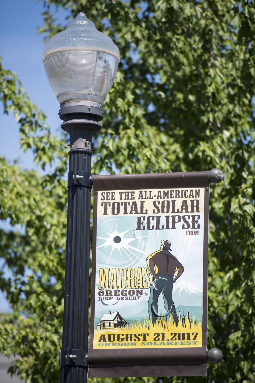
A sign is seen along the roads in Madras, Oregon, where thousands of visitors are expected for the total solar eclipse, Saturday, August 19, 2017. The eclipse will be sweeping across a narrow portion of the contiguous United States from Lincoln Beach, Oregon to Charleston, South Carolina on August 21. A partial solar eclipse will be visible across the entire North American continent along with parts of South America, Africa, and Europe. Photo Credit: (NASA/Aubrey Gemignani)
The Moon is seen passing in front of the Sun during a solar eclipse from Ross Lake, Northern Cascades National Park, Washington on Monday, Aug. 21, 2017. A total solar eclipse swept across a narrow portion of the contiguous United States from Lincoln Beach, Oregon to Charleston, South Carolina. A partial solar eclipse was visible across the entire North American continent along with parts of South America, Africa, and Europe. Photo Credit: (NASA/Bill Ingalls)
The Moon is seen passing in front of the Sun during a total solar eclipse on Monday, August 21, 2017 from onboard a NASA Gulfstream III aircraft flying 25,000 feet above the Oregon coast. A total solar eclipse swept across a narrow portion of the contiguous United States from Lincoln Beach, Oregon to Charleston, South Carolina. A partial solar eclipse was visible across the entire North American continent along with parts of South America, Africa, and Europe. Photo Credit: (NASA/Carla Thomas)

Smokey Bear, left, and Judy Reese of the Crooked River National Grassland, right, wave at passersby as crowds arrive to watch the total solar eclipse in Madras, Oregon on Saturday, August 19, 2017. The eclipse will be sweeping across a narrow portion of the contiguous United States from Lincoln Beach, Oregon to Charleston, South Carolina on August 21. A partial solar eclipse will be visible across the entire North American continent along with parts of South America, Africa, and Europe. Photo Credit: (NASA/Aubrey Gemignani)

The Moon is seen passing in front of the Sun at the point of the maximum of the partial solar eclipse near Banner, Wyoming on Monday, Aug. 21, 2017. A total solar eclipse swept across a narrow portion of the contiguous United States from Lincoln Beach, Oregon to Charleston, South Carolina. A partial solar eclipse was visible across the entire North American continent along with parts of South America, Africa, and Europe. Photo Credit: (NASA/Joel Kowsky)

NASA employees and contractors use protective glasses to view a partial solar eclipse from NASA Headquarters Monday, Aug. 21, 2017 in Washington. A total solar eclipse swept across a narrow portion of the contiguous United States from Lincoln Beach, Oregon to Charleston, South Carolina. A partial solar eclipse was visible across the entire North American continent along with parts of South America, Africa, and Europe. Photo Credit: (NASA/Gwen Pitman)

NASA employees and contractors use protective glasses to view a partial solar eclipse from NASA Headquarters Tuesday, Aug. 22, 2017 in Washington. A total solar eclipse swept across a narrow portion of the contiguous United States from Lincoln Beach, Oregon to Charleston, South Carolina. A partial solar eclipse was visible across the entire North American continent along with parts of South America, Africa, and Europe. Photo Credit: (NASA/Gwen Pitman)
The Moon is seen passing in front of the Sun during a solar eclipse from Ross Lake, Northern Cascades National Park, Washington on Monday, Aug. 21, 2017. A total solar eclipse swept across a narrow portion of the contiguous United States from Lincoln Beach, Oregon to Charleston, South Carolina. A partial solar eclipse was visible across the entire North American continent along with parts of South America, Africa, and Europe. Photo Credit: (NASA/Bill Ingalls)

NASA employees and contractors use protective glasses to view a partial solar eclipse from NASA Headquarters Monday, Aug. 21, 2017 in Washington. A total solar eclipse swept across a narrow portion of the contiguous United States from Lincoln Beach, Oregon to Charleston, South Carolina. A partial solar eclipse was visible across the entire North American continent along with parts of South America, Africa, and Europe. Photo Credit: (NASA/Gwen Pitman)
The Moon is seen passing in front of the Sun during a total solar eclipse on Monday, August 21, 2017 from onboard a NASA Gulfstream III aircraft flying 25,000 feet above the Oregon coast. A total solar eclipse swept across a narrow portion of the contiguous United States from Lincoln Beach, Oregon to Charleston, South Carolina. A partial solar eclipse was visible across the entire North American continent along with parts of South America, Africa, and Europe. Photo Credit: (NASA/Carla Thomas)

Some prominences are seen as the moon begins to move off the sun during the total solar eclipse on Monday, August 21, 2017 above Madras, Oregon. A total solar eclipse swept across a narrow portion of the contiguous United States from Lincoln Beach, Oregon to Charleston, South Carolina. A partial solar eclipse was visible across the entire North American continent along with parts of South America, Africa, and Europe. Photo Credit: (NASA/Aubrey Gemignani)
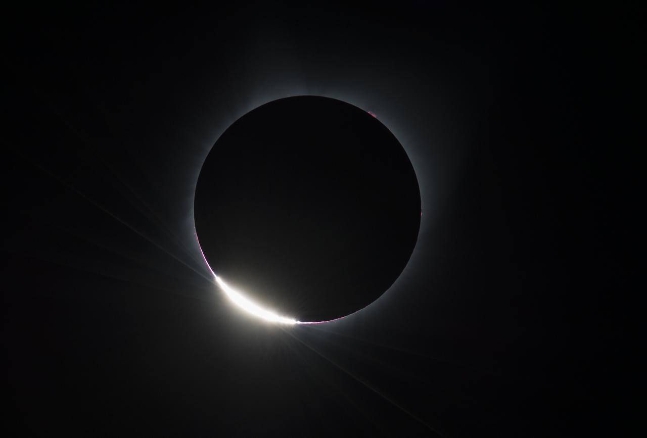
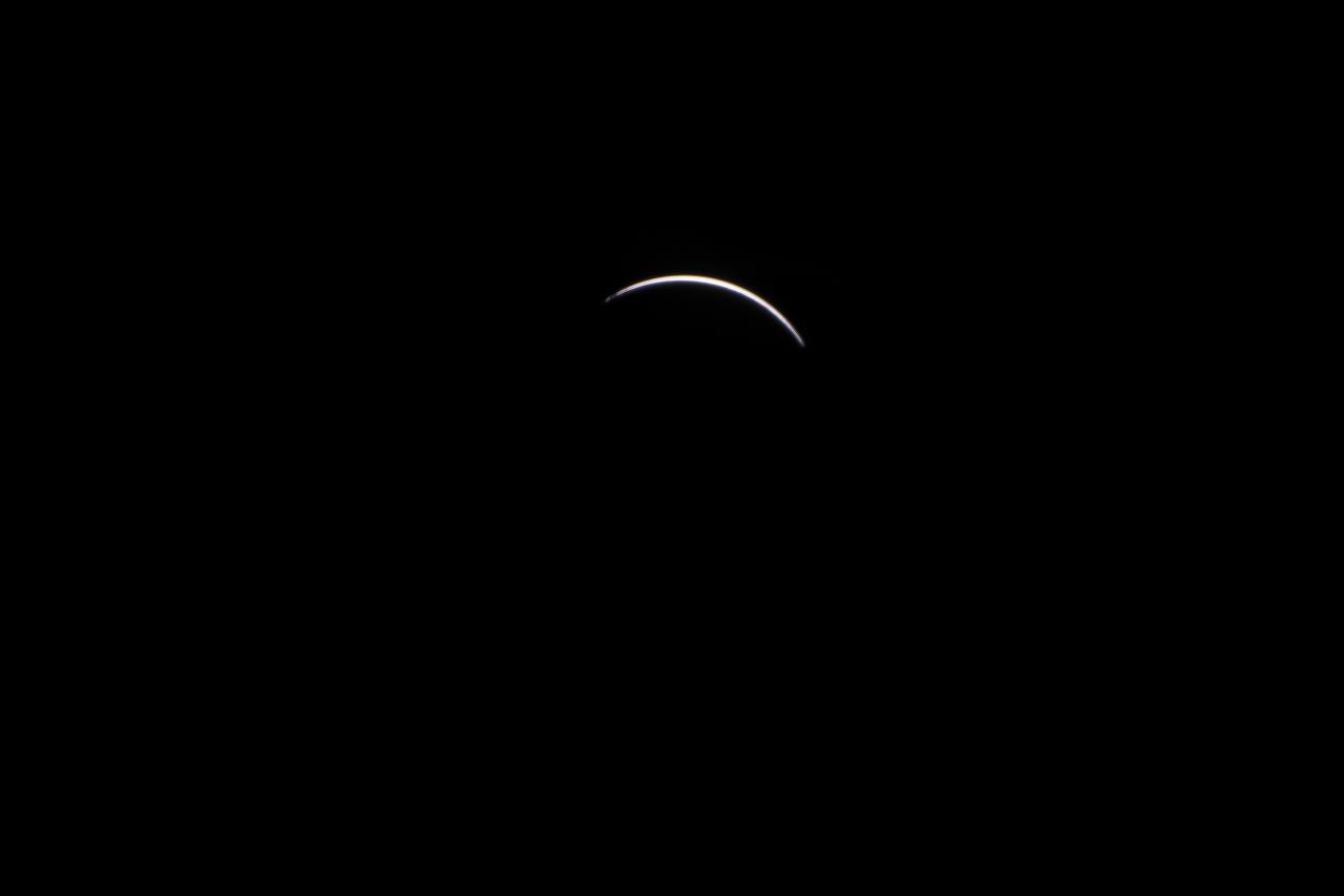
The Diamond Ring effect is seen as the moon makes its final move over the sun during the total solar eclipse on Monday, August 21, 2017 above Madras, Oregon. A total solar eclipse swept across a narrow portion of the contiguous United States from Lincoln Beach, Oregon to Charleston, South Carolina. A partial solar eclipse was visible across the entire North American continent along with parts of South America, Africa, and Europe. Photo Credit: (NASA/Aubrey Gemignani)

NASA employees and contractors use protective glasses to view a partial solar eclipse from NASA Headquarters Monday, Aug. 21, 2017 in Washington. A total solar eclipse swept across a narrow portion of the contiguous United States from Lincoln Beach, Oregon to Charleston, South Carolina. A partial solar eclipse was visible across the entire North American continent along with parts of South America, Africa, and Europe. Photo Credit: (NASA/Gwen Pitman)

A man drums during the partial phase of the total solar eclipse in Madras, Oregon on Monday, Aug. 21, 2017. A total solar eclipse swept across a narrow portion of the contiguous United States from Lincoln Beach, Oregon to Charleston, South Carolina. A partial solar eclipse was visible across the entire North American continent along with parts of South America, Africa, and Europe. Photo Credit: (NASA/Aubrey Gemignani)
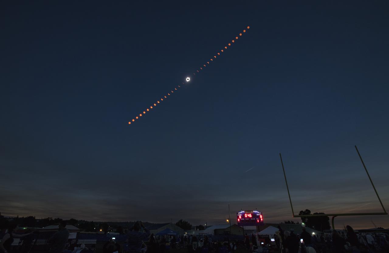
This composite image shows the progression of a total solar eclipse over Madras, Oregon on Monday, Aug. 21, 2017. A total solar eclipse swept across a narrow portion of the contiguous United States from Lincoln Beach, Oregon to Charleston, South Carolina. A partial solar eclipse was visible across the entire North American continent along with parts of South America, Africa, and Europe. Photo Credit: (NASA/Aubrey Gemignani)

NASA employees and contractors use protective glasses to view a partial solar eclipse from NASA Headquarters Monday, Aug. 21, 2017 in Washington. A total solar eclipse swept across a narrow portion of the contiguous United States from Lincoln Beach, Oregon to Charleston, South Carolina. A partial solar eclipse was visible across the entire North American continent along with parts of South America, Africa, and Europe. Photo Credit: (NASA/Gwen Pitman)
A total solar eclipse is seen on Monday, August 21, 2017 above Madras, Oregon. A total solar eclipse swept across a narrow portion of the contiguous United States from Lincoln Beach, Oregon to Charleston, South Carolina. A partial solar eclipse was visible across the entire North American continent along with parts of South America, Africa, and Europe. Photo Credit: (NASA/Aubrey Gemignani)

The Moon is seen passing in front of the Sun during a total solar eclipse on Monday, August 21, 2017 from onboard a NASA Gulfstream III aircraft flying 25,000 feet above the Oregon coast. A total solar eclipse swept across a narrow portion of the contiguous United States from Lincoln Beach, Oregon to Charleston, South Carolina. A partial solar eclipse was visible across the entire North American continent along with parts of South America, Africa, and Europe. Photo Credit: (NASA/Carla Thomas)

A sign is seen along the roads in Madras, Oregon, where thousands of visitors are expected for the total solar eclipse, Saturday, August 19, 2017. The eclipse will be sweeping across a narrow portion of the contiguous United States from Lincoln Beach, Oregon to Charleston, South Carolina on August 21. A partial solar eclipse will be visible across the entire North American continent along with parts of South America, Africa, and Europe. Photo Credit: (NASA/Aubrey Gemignani)
A total solar eclipse is seen on Monday, August 21, 2017 above Madras, Oregon. A total solar eclipse swept across a narrow portion of the contiguous United States from Lincoln Beach, Oregon to Charleston, South Carolina. A partial solar eclipse was visible across the entire North American continent along with parts of South America, Africa, and Europe. Photo Credit: (NASA/Aubrey Gemignani)

The Vasquez family from Eureka and Edgewood, Washington take a photo during the total solar eclipse in Madras, Oregon on Monday, Aug. 21, 2017. A total solar eclipse swept across a narrow portion of the contiguous United States from Lincoln Beach, Oregon to Charleston, South Carolina. A partial solar eclipse was visible across the entire North American continent along with parts of South America, Africa, and Europe. Photo Credit: (NASA/Aubrey Gemignani)

At about 6:00 a.m. EDT (10:00 UTC) on May 10, 2015, Tropical Storm Ana made landfall between Myrtle Beach and North Myrtle Beach, South Carolina. One day earlier, on the morning of May 9, the Moderate Resolution Imaging Spectroradiometer (MODIS) on NASA’s Terra satellite acquired this true-color image of the storm off the coast of the Carolinas. At the time, Ana had just evolved from a subtropical storm to a tropical storm with maximum sustained winds of 93 kilometers (58 miles) per hour. Ana’s life ashore was brief – the storm was downgraded to a tropical depression at 2:00 p.m. EDT (14:00 UTC) on May 10. During that time, parts of South Carolina and eastern North Carolina was drenched with heavy rain – some areas reported over 6 inches of rainfall – and heavy winds. A water spout was reported in Dare County, North Carolina, and the storm contributed to significant beach erosion along the coast. Credit: NASA/GSFC/Jeff Schmaltz/MODIS Land Rapid Response Team <b><a href="http://www.nasa.gov/audience/formedia/features/MP_Photo_Guidelines.html" rel="nofollow">NASA image use policy.</a></b> <b><a href="http://www.nasa.gov/centers/goddard/home/index.html" rel="nofollow">NASA Goddard Space Flight Center</a></b> enables NASA’s mission through four scientific endeavors: Earth Science, Heliophysics, Solar System Exploration, and Astrophysics. Goddard plays a leading role in NASA’s accomplishments by contributing compelling scientific knowledge to advance the Agency’s mission. <b>Follow us on <a href="http://twitter.com/NASAGoddardPix" rel="nofollow">Twitter</a></b> <b>Like us on <a href="http://www.facebook.com/pages/Greenbelt-MD/NASA-Goddard/395013845897?ref=tsd" rel="nofollow">Facebook</a></b> <b>Find us on <a href="http://instagrid.me/nasagoddard/?vm=grid" rel="nofollow">Instagram</a></b>

Lili Bornio, right, and her mom, set up to sell eclipse shirts and stickers, that she designed, to raise money for medical school, in Madras, Oregon on Saturday, August 19, 2017. Thousands of visitors are expected in Madras to view the total solar eclipse. The eclipse will be sweeping across a narrow portion of the contiguous United States from Lincoln Beach, Oregon to Charleston, South Carolina on August 21. A partial solar eclipse will be visible across the entire North American continent along with parts of South America, Africa, and Europe. Photo Credit: (NASA/Aubrey Gemignani)

Carol Jensen, a produce purveyor for Black Bear Diner, is seen displaying solar glasses for sale at Black Bear Diner in Madras, Oregon on Saturday, August 19, 2017. She is volunteering her time to help prepare for the crowds arriving to watch the total solar eclipse. The eclipse will be sweeping across a narrow portion of the contiguous United States from Lincoln Beach, Oregon to Charleston, South Carolina on August 21. A partial solar eclipse will be visible across the entire North American continent along with parts of South America, Africa, and Europe. Photo Credit: (NASA/Aubrey Gemignani)
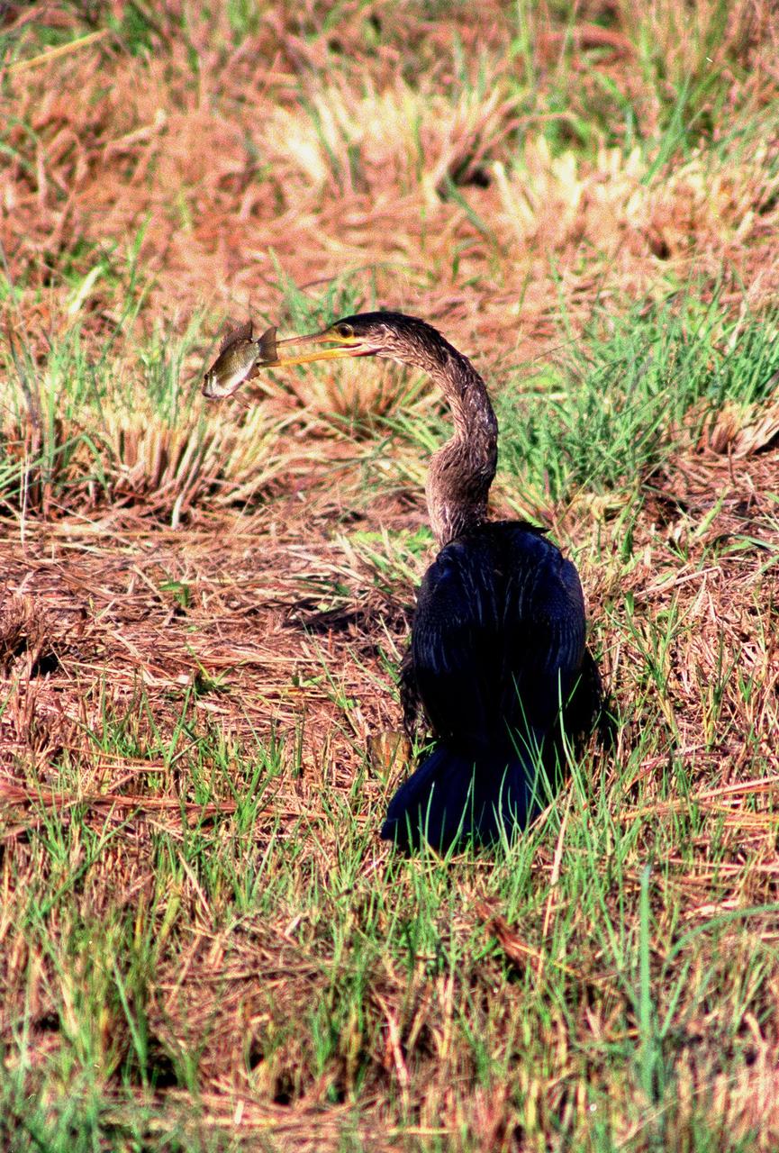
KENNEDY SPACE CENTER, FLA. -- Spotted in the Merritt Island National Wildlife Refuge, which shares a boundary with the space center, an anhinga captures a fish in its long, dagger-shaped bill. It is also known as the "snakebird" because in the water its body is submerged so that only its head and long, slender neck are visible. Ranging the Atlantic and Gulf Coasts from North Carolina to Texas, north in the Mississippi Valley to Arkansas and Tennessee, and in the South to South America, it inhabits freshwater ponds and swamps with thick vegetation. They are often seen with wings half-open, drying them in the sun since they lack oil glands with which to preen
This composite image of seven pictures shows the progression of a partial solar eclipse near from Ross Lake, Northern Cascades National Park, Washington on Monday, Aug. 21, 2017. The second to the last frame shows the International Space Station, with a crew of six onboard, in silhouette as it transits the Sun at roughly five miles per second. A total solar eclipse swept across a narrow portion of the contiguous United States from Lincoln Beach, Oregon to Charleston, South Carolina. A partial solar eclipse was visible across the entire North American continent along with parts of South America, Africa, and Europe. Photo Credit: (NASA/Bill Ingalls)

Robert Lightfoot, acting NASA administrator and Thomas Zurbuchen NASA AA for the science mission directorate view a partial eclipse solar eclipse Monday, August 21, 2017, from onboard a NASA Armstrong Flight Research Center’s Gulfstream III 35,000 feet above the Oregon Coast. A total solar eclipse swept across a narrow portion of the contiguous United States from Lincoln Beach, Oregon to Charleston, South Carolina. Photo Credit: (NASA/Carla Thomas)

KENNEDY SPACE CENTER, FLA. - This snail was photographed near the NASA Kennedy Space Center Shuttle Landing Facility. It appears to have the characteristics of the “Rosy Predator Snail,” which is found in Southeastern Texas, Louisiana, Mississippi, Alabama, Georgia, South Carolina and is widespread in Florida including the Keys. It is usually found singly in hardwood forests, roadsides and urban gardens. The Shuttle Landing Facility backs up to the Banana Creek and surrounding marshes.

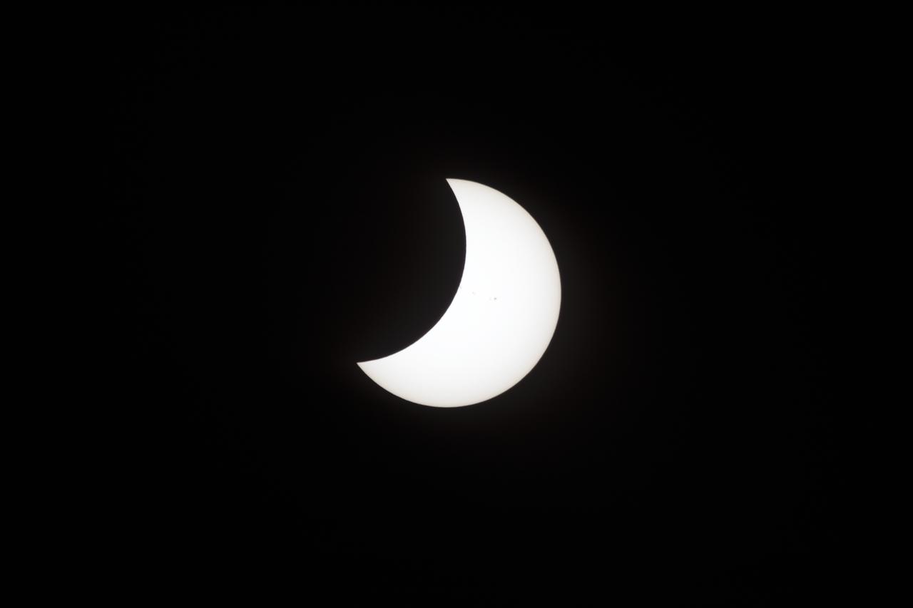
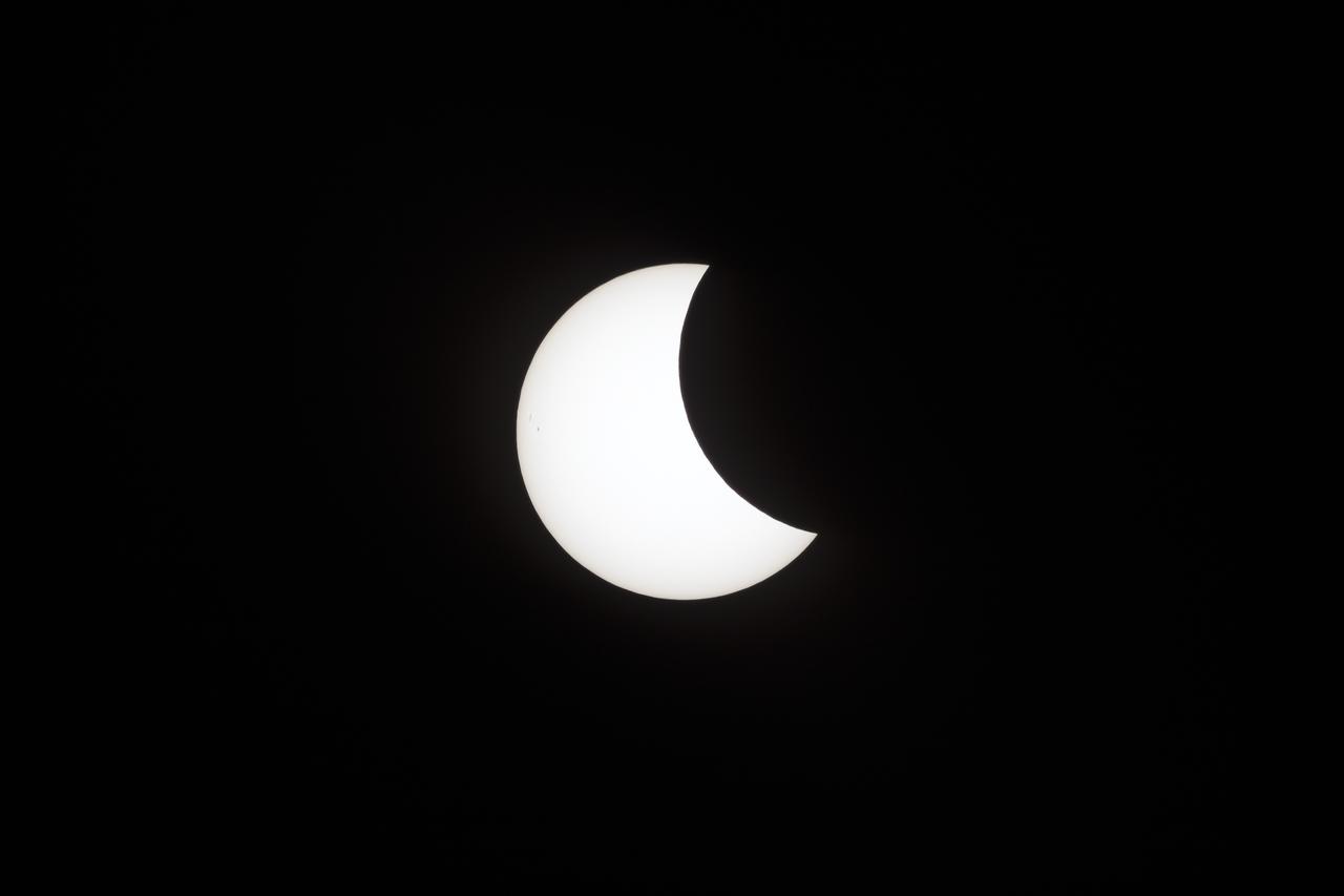
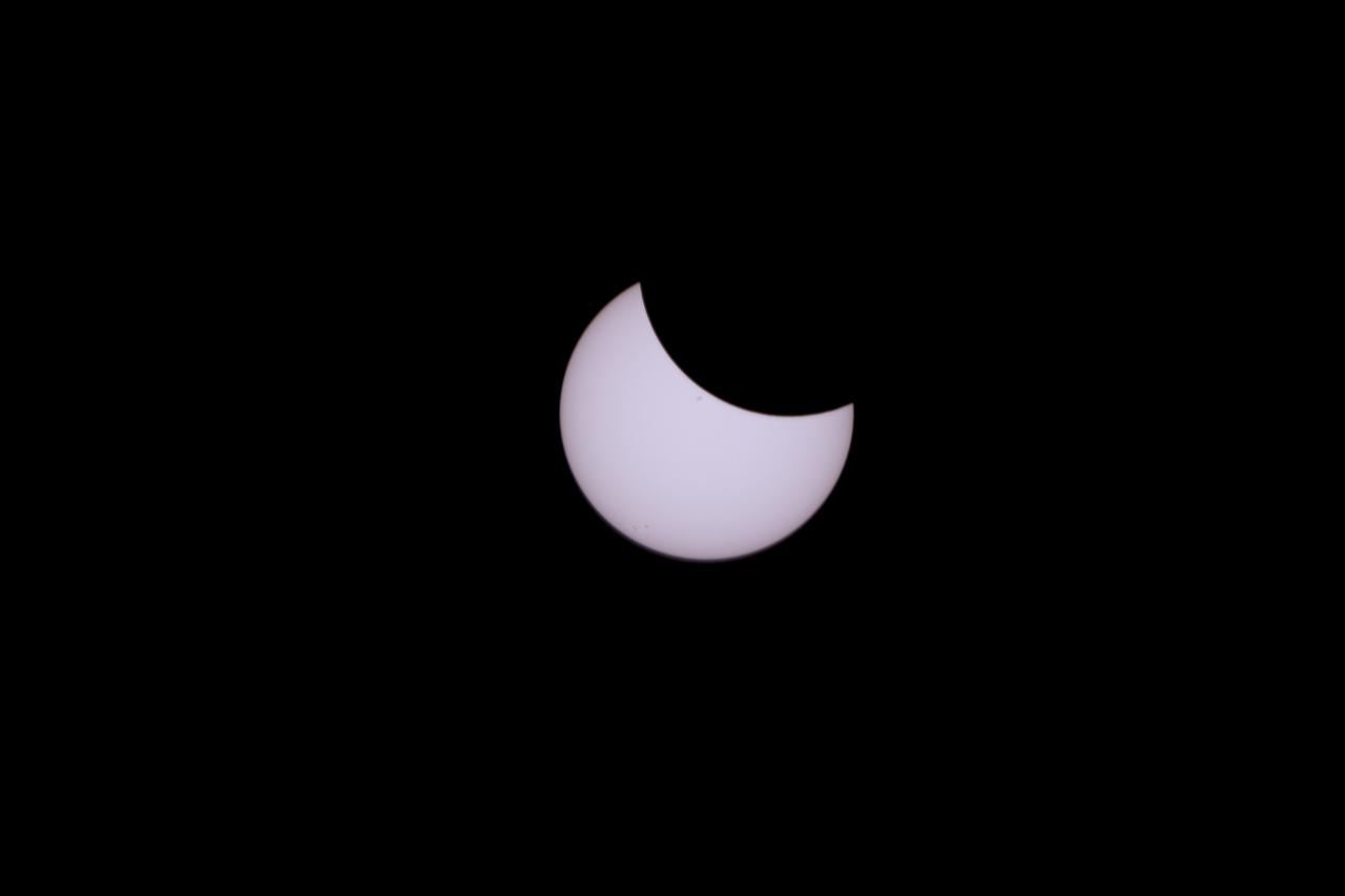
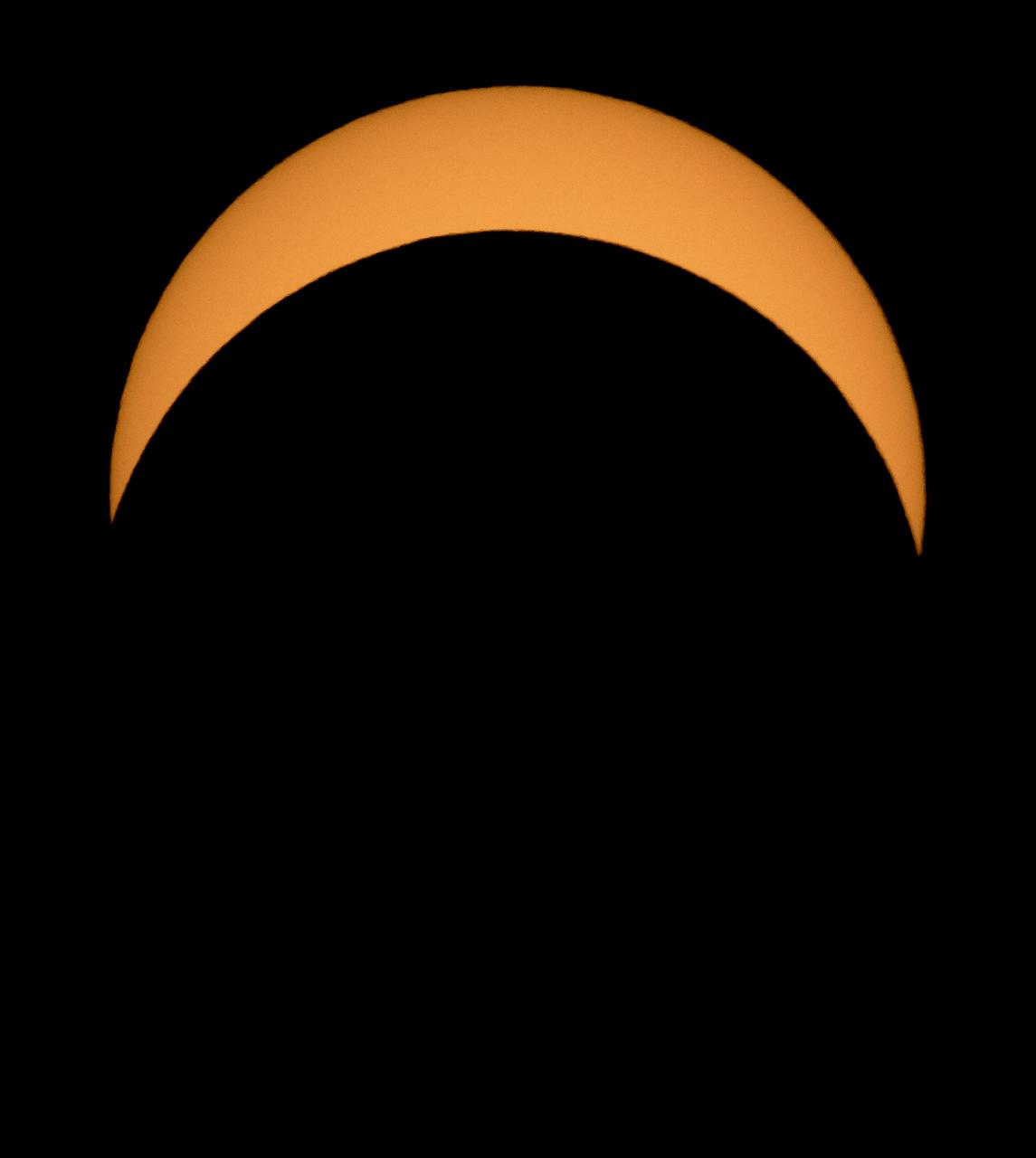
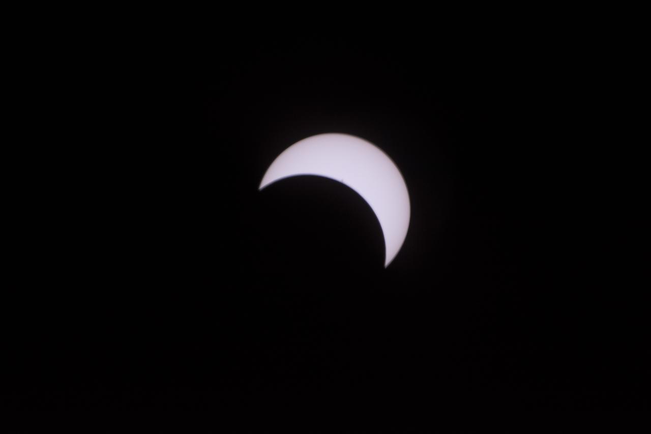
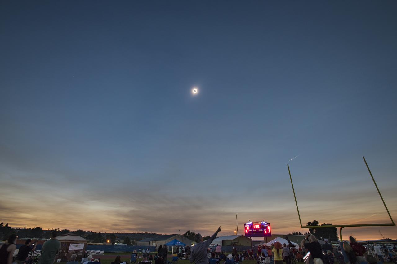
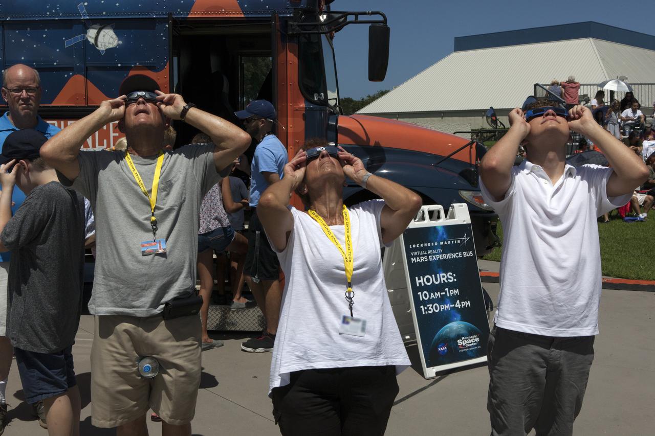
From the Kennedy Space Center Visitor Complex, guests joined Americans from coast to coast following the solar eclipse. Although a partial eclipse on Florida's Space Coast, young and old alike found many ways to watch the rare astronomical event. As the Moon passed between Earth and the midafternoon Sun, a shadow moved across the landscape. The 70-mile-wide totality path, or "umbral cone" -- where the entire Sun will vanish behind the Moon -- stretched across 14 states, from Oregon to South Carolina.

From the Kennedy Space Center Visitor Complex, guests joined Americans from coast to coast following the solar eclipse. Although a partial eclipse on Florida's Space Coast, young and old alike found many ways to watch the rare astronomical event. As the Moon passed between Earth and the midafternoon Sun, a shadow moved across the landscape. The 70-mile-wide totality path, or "umbral cone" -- where the entire Sun will vanish behind the Moon -- stretched across 14 states, from Oregon to South Carolina.

From the Kennedy Space Center Visitor Complex, guests joined Americans from coast to coast following the solar eclipse. Although a partial eclipse on Florida's Space Coast, young and old alike found many ways to watch the rare astronomical event. As the Moon passed between Earth and the midafternoon Sun, a shadow moved across the landscape. The 70-mile-wide totality path, or "umbral cone" -- where the entire Sun will vanish behind the Moon -- stretched across 14 states, from Oregon to South Carolina.
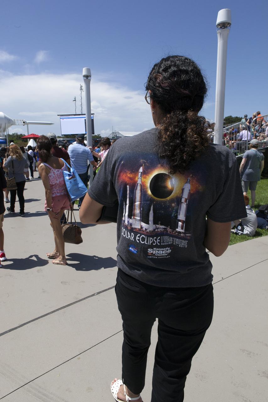
From the Kennedy Space Center Visitor Complex, guests joined Americans from coast to coast following the solar eclipse. Although a partial eclipse on Florida's Space Coast, young and old alike found many ways to watch the rare astronomical event. As the Moon passed between Earth and the midafternoon Sun, a shadow moved across the landscape. The 70-mile-wide totality path, or "umbral cone" -- where the entire Sun will vanish behind the Moon -- stretched across 14 states, from Oregon to South Carolina.
AS09-23-3568 (3-13 March 1969) --- Atlantic coast of South Carolina as photographed from the Apollo 9 spacecraft during its Earth-orbital mission. The visible coastline extends from the mouth of the Savannah River northeastward to the mouth of the Santee River. The city of Charleston is on the coast in the center of picture. Lake Moultrie is at left center edge of picture.

From the Kennedy Space Center Visitor Complex, guests joined Americans from coast to coast following the solar eclipse. Although a partial eclipse on Florida's Space Coast, young and old alike found many ways to watch the rare astronomical event. As the Moon passed between Earth and the midafternoon Sun, a shadow moved across the landscape. The 70-mile-wide totality path, or "umbral cone" -- where the entire Sun will vanish behind the Moon -- stretched across 14 states, from Oregon to South Carolina.

A total solar eclipse is seen on Monday, August 21, 2017 from onboard a NASA Armstrong Flight Research Center’s Gulfstream III 25,000 feet above the Oregon coast. A total solar eclipse swept across a narrow portion of the contiguous United States from Lincoln Beach, Oregon to Charleston, South Carolina. Photo Credit: (NASA/Carla Thomas)

AS09-20-3126 (3-13 March 1969) --- Oblique view of the U.S. South Atlantic coastal area as photographed from the Apollo 9 spacecraft during its Earth-orbital mission in March of 1969. This view shows area north from Goldsboro, North Carolina, looking over the Pamlico River and Albemarle Sound at the Portsmouth-Norfolk-Newport News area. The Delaware peninsula and New Jersey lie under snow. Long Island, New York, is barely visible under the clouds in the background. Richmond is left of center.

Robert Lightfoot, acting NASA administrator and Thomas Zurbuchen NASA AA for the science mission directorate view a partial eclipse solar eclipse Monday, August 21, 2017, from onboard a NASA Armstrong Flight Research Center’s Gulfstream III 35,000 feet above the Oregon Coast. A total solar eclipse swept across a narrow portion of the contiguous United States from Lincoln Beach, Oregon to Charleston, South Carolina. Photo Credit: (NASA/Carla Thomas)

ISS043E182261 (05/08/2015) --- This image of Tropical Storm Anna taken from the International Space Station displays the view looking south-southeastward from western Virginia towards storm about 200 miles east of Savannah, Georgia, Bahamas and Florida in the distance. Expedition 43 NASA astronaut Scott Kelly and his crewmates captured many images of the Earth showing the storms progression onto the Carolina's and other east coast states.

In this oblique view of the Georgia and South Carolina coast, the southern most Appalachians (32.0N, 83.0W) dominate the foreground. Contrails criss cross over Atlanta, a major airline hub. The coastal plain which wraps around the southern Appalachians, is well delineated. Faintly visible under the haze toward Earth's limb are the Great lakes (Lake Michigan near center), the folded belts of the central Appalachians and Long Island, New York.

Robert Lightfoot, acting NASA administrator and Thomas Zurbuchen NASA AA for the science mission directorate view a partial eclipse solar eclipse Monday, August 21, 2017, from onboard a NASA Armstrong Flight Research Center’s Gulfstream III 35,000 feet above the Oregon Coast. A total solar eclipse swept across a narrow portion of the contiguous United States from Lincoln Beach, Oregon to Charleston, South Carolina. Photo Credit: (NASA/Carla Thomas)
A total solar eclipse is seen on Monday, August 21, 2017 from onboard a NASA Armstrong Flight Research Center’s Gulfstream III 25,000 feet above the Oregon coast. A total solar eclipse swept across a narrow portion of the contiguous United States from Lincoln Beach, Oregon to Charleston, South Carolina. Photo Credit: (NASA/Carla Thomas)

From the Kennedy Space Center Visitor Complex, guests joined Americans from coast to coast following the solar eclipse. Although a partial eclipse on Florida's Space Coast, young and old alike found many ways to watch the rare astronomical event. As the Moon passed between Earth and the midafternoon Sun, a shadow moved across the landscape. The 70-mile-wide totality path, or "umbral cone" -- where the entire Sun will vanish behind the Moon -- stretched across 14 states, from Oregon to South Carolina.

From the Kennedy Space Center Visitor Complex, guests joined Americans from coast to coast following the solar eclipse. Although a partial eclipse on Florida's Space Coast, young and old alike found many ways to watch the rare astronomical event. As the Moon passed between Earth and the midafternoon Sun, a shadow moved across the landscape. The 70-mile-wide totality path, or "umbral cone" -- where the entire Sun will vanish behind the Moon -- stretched across 14 states, from Oregon to South Carolina.
From the Kennedy Space Center Visitor Complex, guests joined Americans from coast to coast following the solar eclipse. Although a partial eclipse on Florida's Space Coast, young and old alike found many ways to watch the rare astronomical event. As the Moon passed between Earth and the midafternoon Sun, a shadow moved across the landscape. The 70-mile-wide totality path, or "umbral cone" -- where the entire Sun will vanish behind the Moon -- stretched across 14 states, from Oregon to South Carolina.

From the Kennedy Space Center Visitor Complex, guests joined Americans from coast to coast following the solar eclipse. Although a partial eclipse on Florida's Space Coast, young and old alike found many ways to watch the rare astronomical event. As the Moon passed between Earth and the midafternoon Sun, a shadow moved across the landscape. The 70-mile-wide totality path, or "umbral cone" -- where the entire Sun will vanish behind the Moon -- stretched across 14 states, from Oregon to South Carolina.
A total solar eclipse is seen on Monday, August 21, 2017 from onboard a NASA Armstrong Flight Research Center’s Gulfstream III 25,000 feet above the Oregon coast. A total solar eclipse swept across a narrow portion of the contiguous United States from Lincoln Beach, Oregon to Charleston, South Carolina. Photo Credit: (NASA/Carla Thomas)

From the Kennedy Space Center Visitor Complex, guests joined Americans from coast to coast following the solar eclipse. Although a partial eclipse on Florida's Space Coast, young and old alike found many ways to watch the rare astronomical event. As the Moon passed between Earth and the midafternoon Sun, a shadow moved across the landscape. The 70-mile-wide totality path, or "umbral cone" -- where the entire Sun will vanish behind the Moon -- stretched across 14 states, from Oregon to South Carolina.

STS081-720-081 (12-22 Jan. 1997) --- As seen from Russia's Mir space station while docked to the Space Shuttle Atlantis, this scene provides a panorama of the central Atlantic coast of the United States. The view extends from the Chesapeake Bay at the top of the view to Charleston, South Carolina near the lower right corner. Heavy snow-cover on the Appalachian Mountains (on the left of the photo) contrasts with the darker piedmont. The dark piedmont, in turn, changes sharply in the center of the photo to the gray-colored coastal plain. Cape Hatteras, Cape Lookout and Cape Fear (top to bottom) mark the points along the North Carolina coast. Another boundary can be seen offshore. The clouds and the line of lighter-colored water off Cape Hatteras mark the western edge of the warm Gulf Stream which runs northward along the coast to Cape Hatteras before it shoots eastward across the Atlantic.

KENNEDY SPACE CENTER, FLA. - At NASA Kennedy Space Center, roseate spoonbills (front) and white ibis search the murky canal for food. Spoonbills inhabit areas of mangroves such as on the coasts of southern Florida and Texas. These birds feed on shrimp and fish in the shallow water, sweeping their bills from side to side. White ibis inhabit marshy sloughs, mud flats, lagoons and swamp forests along the coast from South Carolina to Florida and Texas and south to northern South America. The Center shares a boundary with the Merritt Island National Wildlife Refuge, which is a habitat for more than 310 species of birds, 25 mammals, 117 fishes and 65 amphibians and reptiles. In addition, the Refuge supports 19 endangered or threatened wildlife species on Federal or State lists, more than any other single refuge in the U.S. Photo credit: NASA/Jim Grossmann

KENNEDY SPACE CENTER, FLA. - At NASA Kennedy Space Center, a roseate spoonbill (front) and white ibis search the murky canal for food. Spoonbills inhabit areas of mangrove such as on the coasts of southern Florida and Texas. These birds feed on shrimps and fish in the shallow water, sweeping their bills from side to side. White ibis inhabit marshy sloughs, mud flats, lagoons and swamp forests along the coast from South Carolina to Florida and Texas and south to northern South America. The ibis with the brown wings is an immature ibis. The Center shares a boundary with the Merritt Island National Wildlife Refuge, which is a habitat for more than 310 species of birds, 25 mammals, 117 fishes and 65 amphibians and reptiles. In addition, the Refuge supports 19 endangered or threatened wildlife species on Federal or State lists, more than any other single refuge in the U.S. Photo credit: NASA/Jim Grossmann