These images from NASATerra satellite are of Southern California acquired on March 14, 2000 during Terra orbit 1273. North is at the top.
MISR Views Southern California
This is an image of the southern portion of the Baja California Peninsula taken by NASA EarthKAM on February 12, 2000. The Pacific Ocean lies to the west and the Gulf of California to the east.
Southern Tip of Baja California, Mexico
This frame from an animation depicts variations in surface elevation resulting from the discharge and recharge of groundwater basins in Southern California.
Southern California INSAR Time Series
Southern California Santa Anas are dry, north-easterly winds having speeds in excess of 25 knots 46 kilometers/hour. Santa Ana conditions are commonly associated with gusts of more than twice this level.
Dusty Skies over Southern California
The Orion team visits Southern California Braiding in Bell Gardens, CA on Jan. 29, 2014. Part of Batch image transfer from Flickr.
Southern California Braiding
The Orion team visits Southern California Braiding in Bell Gardens, CA on Jan. 29, 2014. Part of Batch image transfer from Flickr.
Southern California Braiding
The Orion team visits Southern California Braiding in Bell Gardens, CA on Jan. 29, 2014. Part of Batch image transfer from Flickr.
Southern California Braiding
The Orion team visits Southern California Braiding in Bell Gardens, CA on Jan. 29, 2014. Part of Batch image transfer from Flickr.
Southern California Braiding
The Orion team visits Southern California Braiding in Bell Gardens, CA on Jan. 29, 2014. Part of Batch image transfer from Flickr.
Southern California Braiding
Image from a NASA aircraft, TG-14, over the Superbloom of wildflowers and poppies from the Antelope Valley in Southern California
Rainy Winter Season Brings Abundance of Wildflowers and Poppies in Southern California's Antelope Valley. The poppy is the state flower.
Brush fires consumed nearly 750,000 acres across Southern California between October 21 and November 18, 2003. Burn scars and vegetation changes wrought by the fires are illustrated in these false-color images from NASA Terra spacecraft.
Burn Scars Across Southern California
From the desert to the mountains to the sea, this image acquired by NASA Shuttle Radar Topography Mission SRTM in Feb. 2000, shows in striking detail the varied topography of Southern California.
Southern California Shaded Relief, Color as Height
The Multi-angle Imaging SpectroRadiometer MISR instrument on NASA Terra satellite captured this Aug. 30 image of smoke plumes from the Station and other wildfires burning throughout Southern California.
Smoke from Station Fire Blankets Southern California
View from a NASA aircraft, TG-14, over the Superbloom of wildflowers and poppies from the Antelope Valley in Southern California and Poppy Reserve and solar panels in background
Rainy Winter Season Brings Abundance of Wildflowers and Poppies in Southern California’s Antelope Valley. The poppy is the state flower.
View from a NASA aircraft, TG-14, over the Superbloom of yellow wildflowers and orange poppies from the Antelope Valley in Southern California. The poppy is the state flower.
Rainy Winter Season Brings Abundance of Wildflowers and Poppies in Southern California’s Antelope Valley. The poppy is the state flower.
The scope and extent of the strong Santa Ana wind event in Southern California the week of Oct. 21, 2007, is visible in this image from NASA QuikScat satellite.
NASA QuikScat Maps Southern California Destructive Santa Ana Winds
View from a NASA aircraft, TG-14, over the Superbloom of yellow wildflowers and orange poppies from the Antelope Valley in Southern California, Poppy Reserve and solar panels are in the background.
Rainy Winter Season Brings Abundance of Wildflowers and Poppies in Southern California’s Antelope Valley. The Poppy is the state flower.
View from a NASA aircraft, TG-14, over the Superbloom of wildflowers and poppies from the Antelope Valley in Southern California. The Poppy Reserve is in the foreground and solar panels are in the background.
Rainy Winter Season Brings Abundance of Wildflowers and Poppies in Southern California’s Antelope Valley showing Poppy Reserve and solar panels are in the background.
NASA’s T-34 aircraft flown from the agency’s Armstrong Flight Research Center heading toward Southern California’s Antelope Valley Poppy Reserve. The aircraft was flown from the agency’s Armstrong Flight Research Center.
NASA Aircraft heads to Southern California’s Poppy Reserve in the foreground. Rainy Season made the Antelope Valley colorful with poppies and wildflowers.
NASA's T-34 aircraft flown from the agency's Armstrong Flight Research Center aims the plane toward Southern California's Antelope Valley Poppy Reserve. The aircraft was flown from the agency's Armstrong Flight Research Center.
NASA Aircraft heads to Southern California's Poppy Reserve in the foreground. Rainy Season made the Antelope Valley colorful with poppies and wildflowers.
This view of southern California as seen from the Apollo 7 spacecraft during its 18th revolution of the earth. Photographed from an altitude of 124 nautical miles. The coast of California can be seen from Point Mugu southward to Oceanside. Santa Catalina can be seen below the off shore clouds. Details of the Los Angeles area are obscured by pollution which extends from Banning westard for 100 miles to beyond Malibu. In the upper portion of the photograph can be seen (left to right) the San Joaquin Valley beyond Bakersfield, the Techachapi Mountains, the Sierra Nevada, Owens Valley, Death Valley and the Mojave Desert.
Southern California as seen from the Apollo 7 spacecraft
NASA's Airborne Visible Infrared Imaging Spectrometer instrument (AVIRIS), flying aboard a NASA Armstrong Flight Research Center high-altitude ER-2 aircraft, flew over the wildfires burning in Southern California on Dec. 5, 2017 and acquired this false-color image. Active fires are visible in red, ground surfaces are in green and smoke is in blue.  AVIRIS is an imaging spectrometer that observes light in visible and infrared wavelengths, measuring the full spectrum of radiated energy. Unlike regular cameras with three colors, AVIRIS has 224 spectral channels from the visible through the shortwave infrared. This permits mapping of fire temperatures, fractional coverage, and surface properties, including how much fuel is available for a fire. Spectroscopy is also valuable for characterizing forest drought conditions and health to assess fire risk.  AVIRIS has been observing fire-prone areas in Southern California for many years, forming a growing time series of before/after data cubes. These data are helping improve scientific understanding of fire risk and how ecosystems respond to drought and fire.  https://photojournal.jpl.nasa.gov/catalog/PIA11243
NASA's AVIRIS Instrument Sheds New Light on Southern California Wildfires
Boeing astronaut Chris Ferguson takes a selfie during a recent tour of spacecraft testing facilities in southern California. Ferguson, along with NASA astronauts Nicole Mann and Eric Boe, will fly on Boeing’s CST-100 Starliner in an upcoming crew flight test to the International Space Station. During trips to El Segundo and Huntington Beach, the astronauts met with employees who conduct the structural and environmental testing on the spacecraft built to return human spaceflight launch capability to the U.S.
CCP Astronauts Tour Test Facilities in Southern California
NASA astronaut Eric Boe poses during a recent tour of two spacecraft testing facilities in southern California. Boe, along with Boeing astronaut Chris Ferguson and NASA astronaut Nicole Mann, will fly on Boeing’s CST-100 Starliner in an upcoming crew flight test to the International Space Station. During trips to El Segundo and Huntington Beach, the astronauts met with employees who conduct the structural and environmental testing on the spacecraft built to return human spaceflight launch capability to the U.S.
CCP Astronauts Tour Test Facilities in Southern California
The main body of NASA's Europa Clipper spacecraft is seen in its shipping container, just after arriving aboard a C-17 cargo plane at March Air Reserve Base in Riverside County, California. From there it was delivered by truck to the agency's Jet Propulsion Laboratory in Southern California, where, over the next two years, engineers and technicians will finish assembling the craft by hand. Then it will be tested to make sure it can withstand the journey to Jupiter's icy moon Europa.  The Johns Hopkins Applied Physics Laboratory (APL) in Laurel, Maryland, designed and built the spacecraft body in collaboration with JPL and NASA's Goddard Space Flight Center in Greenbelt, Maryland.  Set to launch in October 2024, Europa Clipper will conduct nearly 50 flybys of Europa, which scientists are confident harbors an internal ocean containing twice as much water as Earth's oceans combined. And the moon may currently have conditions suitable for supporting life. The spacecraft's nine science instruments will gather data on the moon's atmosphere, surface, and interior – information that scientists will use to gauge the depth and salinity of the ocean, the thickness of the ice crust, and potential plumes that may be venting subsurface water into space.  https://photojournal.jpl.nasa.gov/catalog/PIA25238
NASA's Europa Clipper Arrives in Southern California
NASA's 2017 astronaut candidate Kayla Barron practices flying in an X-59 QueSST simulator at Armstrong Flight Research Center, in Southern California. The low boom flight demonstrator, X-59, being built at Lockheed Martin and was designed to fly at supersonic speeds over land without the loud noise of breaking the sound barrier and disturbing communities.
Astronaut Pilots X-59 Simulator at Armstrong Flight Research Center
View from a NASA aircraft, TG-14, over the Superbloom of wildflowers and poppies from the Antelope Valley in Southern California, Poppy Reserve and solar panels are in the background.
Rainy Winter Season Brings Abundance of Wildflowers and Poppies in Southern California’s Antelope Valley. Solar panels are in the background.
The Advanced Rapid Imaging and Analysis (ARIA) team at NASA's Jet Propulsion Laboratory in Pasadena, California, and Caltech, also in Pasadena, created a Damage Proxy Map (DPM) depicting areas in Southern California that are likely damaged (shown by red and yellow pixels) as a result of recent wildfires, including the Thomas Fire in Ventura and Santa Barbara Counties, highlighted in the attached image taken from the DPM. The map is derived from synthetic aperture radar (SAR) images from the Copernicus Sentinel-1 satellites, operated by the European Space Agency (ESA). The images were taken before (Nov. 28, 2017, 6 a.m. PST) and after (Dec. 10, 2017, 6 a.m. PST) the onset of the fires.  The map covers an area of 107 by 107 miles (172 by 172 kilometers), shown by the large red polygon. Each pixel measures about 33 yards (30 meters) across. The color variation from yellow to red indicates increasingly more significant ground surface change. Preliminary validation was done by comparing the map to optical satellite imagery from DigitalGlobe. This damage proxy map should be used as guidance to identify damaged areas, and may be less reliable over vegetated areas. For example, the colored pixels seen over mountainous areas may seem a little scattered even though the reality could be that the contiguous areas were burned. Patches of farmland can also appear as signals due to plowing or irrigation. The full map is available to download from https://aria-share.jpl.nasa.gov/events/20171210-SoCal_Fire/.  https://photojournal.jpl.nasa.gov/catalog/PIA22191
NASA-Produced Map Shows Extent of Southern California Wildfire Damage
NASA's Airborne Visible Infrared Imaging Spectrometer instrument (AVIRIS), flying aboard a NASA Armstrong Flight Research Center high-altitude ER-2 aircraft, observed wildfires burning in Southern California on Dec. 5-7, 2017. AVIRIS is an imaging spectrometer that observes light in visible and infrared wavelengths, measuring the full spectrum of radiated energy. Unlike regular cameras with three colors, AVIRIS has 224 spectral channels, measuring contiguously from the visible through the shortwave infrared. Data from these flights, compared against measurements acquired earlier in the year, show many ways this one instrument can improve both our understanding of fire risk and the response to fires in progress.  The top row in this image compilation shows pre-fire data acquired from June 2017. At top left is a visible-wavelength image similar to what our own eyes would see. The top middle image is a map of surface composition based on analyzing the full electromagnetic spectrum, revealing green vegetated areas and non-photosynthetic vegetation that is potential fuel as well as non-vegetated surfaces that may slow an advancing fire. The image at top right is a remote measurement of the water in tree canopies, a proxy for how much moisture is in the vegetation.  The bottom row in the compilation shows data acquired from the Thomas fire in progress in December 2017. At bottom left is a visible wavelength image. The bottom middle image is an infrared image, with red at 2,250 nanometers showing fire energy, green at 1,650 nanometers showing the surface through the smoke, and blue at 1,000 nanometers showing the smoke itself. The image at bottom right is a fire temperature map using spectroscopic analysis to measure fire thermal emission recorded in the AVIRIS spectra.   https://photojournal.jpl.nasa.gov/catalog/PIA22194
Multiple Aspects of the Southern California Wildfires as Seen by NASA's AVIRIS
The jagged ridges of Southern California's Tehachapi Mountains form the backdrop to NASA's brightly-colored NF-15B testbed aircraft during a research mission.
NASA's highly modified NF-15B research aircraft cruises over Southern California's Tehachapi Mountains near Lake Isabella during a research mission.
This spaceborne radar image shows part of the Mojave Desert in the vicinity of Barstow, California and reveals evidence of human activities in the arid environment of the southern California deserts.
Space Radar Image of Barstow, California
SL4-142-4542 (November 1973-February 1974) --- An oblique view of the Pacific Coast of Southern California, including the Los Angeles and San Diego areas, as seen from the Skylab space station in Earth orbit. This picture was taken by one of the Skylab 4 crewmen using a hand-held 70mm Hasselblad camera with a 100mm lens and SO-368 medium-speed Ektachrome film. The visible coastline extends from San Diego northwesterly to Santa Barbara. The Mojave Desert occupies much of the photograph. This view also includes the Channel Islands off the coast. Note that the higher elevations of the mountains are covered with snow. Photo credit: NASA
Pacific Coast of Southern California including Los Angeles and San Diego
City lights shine brighter during the holidays in the United States when compared with the rest of the year, as shown using a new analysis of daily data from the NASA-NOAA Suomi NPP satellite. Dark green pixels are areas where lights are 50 percent brighter, or more, during December.   Because snow reflects so much light, the researchers could only analyze snow-free cities. They focused on the U.S. West Coast from San Francisco and Los Angeles, and cities south of a rough imaginary line from St. Louis to Washington, D.C.  Credit: Jesse Allen, NASA’s Earth Observatory  Read more: <a href="http://www.nasa.gov/content/goddard/satellite-sees-holiday-lights-brighten-cities." rel="nofollow">www.nasa.gov/content/goddard/satellite-sees-holiday-light...</a>.<b><a href="http://www.nasa.gov/audience/formedia/features/MP_Photo_Guidelines.html" rel="nofollow">NASA image use policy.</a></b>  <b><a href="http://www.nasa.gov/centers/goddard/home/index.html" rel="nofollow">NASA Goddard Space Flight Center</a></b> enables NASA’s mission through four scientific endeavors: Earth Science, Heliophysics, Solar System Exploration, and Astrophysics. Goddard plays a leading role in NASA’s accomplishments by contributing compelling scientific knowledge to advance the Agency’s mission. <b>Follow us on <a href="http://twitter.com/NASAGoddardPix" rel="nofollow">Twitter</a></b> <b>Like us on <a href="http://www.facebook.com/pages/Greenbelt-MD/NASA-Goddard/395013845897?ref=tsd" rel="nofollow">Facebook</a></b> <b>Find us on <a href="http://instagram.com/nasagoddard?vm=grid" rel="nofollow">Instagram</a></b>
Satellite Sees Holiday Lights Brighten Cities - Southern California and the Southwest
AS09-22-3436 (March 1969) --- Los Angeles-Long Beach area of southern California, as photographed from the Apollo 9 spacecraft during its 92nd revolution of Earth. Santa Catalina Island is located off the coast. The California coastline is visible from San Clemente northward to Point Dume. Clouds cover most of the San Gabriel Mountains around Los Angeles.
Los Angeles-Long Beach area of Southern California as seen from Apollo 9
NASA’s 2017 astronaut candidates toured aircraft hangar at Armstrong Flight Research Center, in Southern California where Jenni Sidey-Gibbons looks inside engine nozzle of F-15 jet. The F-15 will fly in tandem with the X-59 QueSST during early flight test stages for the X-59 development.
Astronaut Looks at Nozzle of F-15 at Armstrong Flight Research Center
Southern California dramatic topography plays acritical role in its climate, hydrology, ecology, agriculture, and habitability.
Perspective with Landsat Overlay: Mojave to Ventura, California
NASA Terra spacecraft acquired this image of the Day fire in Ventura County in Southern California in 2006.
Day Fire in Ventura County
The Los Angeles area is currently suffering the effects of three major wildfires that are blanketing the area with smoke. Over the past few days, Southern California has experienced record-breaking temperatures, topping 110 degrees Fahrenheit in some cities. The heat, in combination with offshore winds, helped to stoke the Sherpa Fire west of Santa Barbara, which has been burning since June 15, 2016. Over the weekend of June 18-19, this fire rapidly expanded in size, forcing freeway closures and evacuations of campgrounds and state beaches. On Monday, June 20, two new fires ignited in the San Gabriel Mountains north of Azusa and Duarte, together dubbed the San Gabriel Complex Fire. They have burned more than 4,900 acres since June 20, sending up plumes of smoke visible to many in the Los Angeles basin and triggering air quality warnings. More than 1,400 personnel have been battling the blazes in the scorching heat, and evacuations were ordered for neighborhoods in the foothills.  On June 21, the Multi-angle Imaging SpectroRadiometer (MISR) instrument aboard NASA's Terra satellite captured this view of the San Gabriel Mountains and Los Angeles Basin from its 46-degree forward-viewing camera, which enhances the visibility of the smoke compared to the more conventional nadir (vertical) view. The width of this image is about 75 miles (120 kilometers) across. Smoke from the San Gabriel Complex Fire is visible at the very right of the image. Stereoscopic analysis of MISR's multiple camera angles is used to compute the height of the smoke plume from the San Gabriel Complex Fire. In the right-hand image, these heights are superimposed on the underlying image. The color scale shows that the plume is not much higher than the surrounding mountains. As a result, much of the smoke is confined to the local area.  http://photojournal.jpl.nasa.gov/catalog/PIA20718
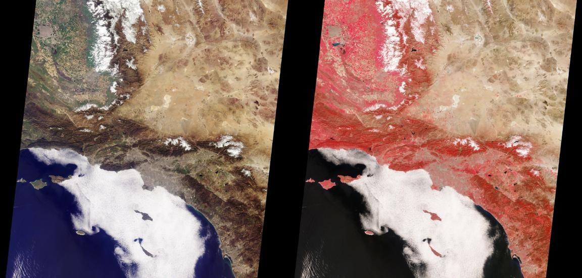
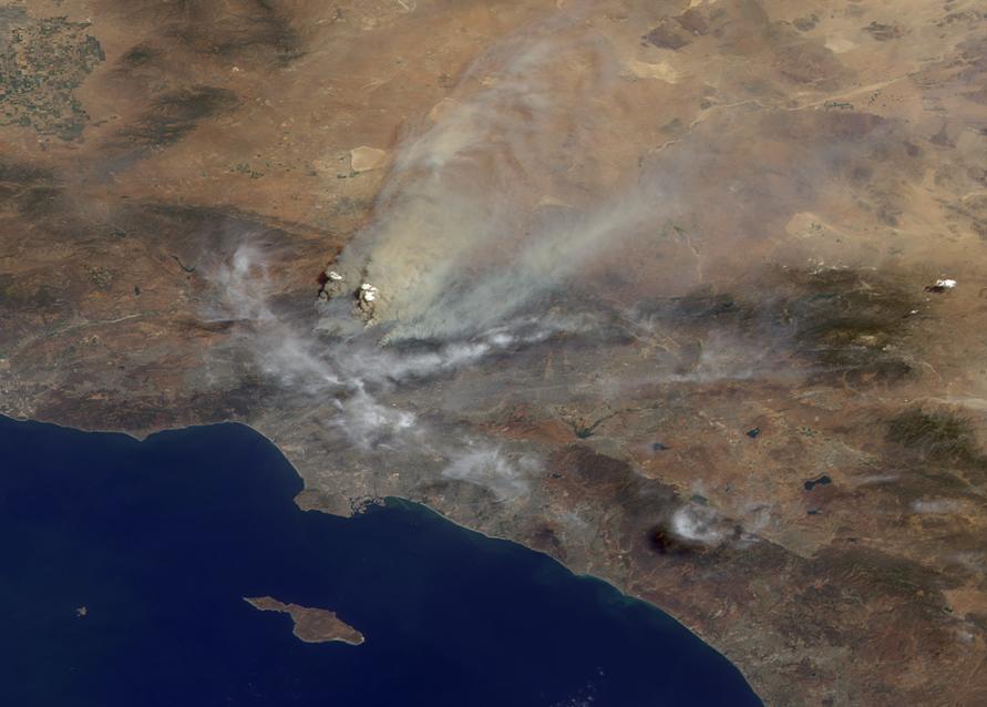
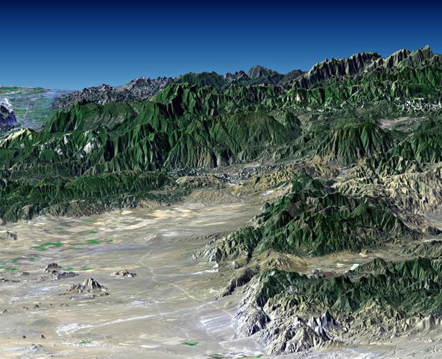
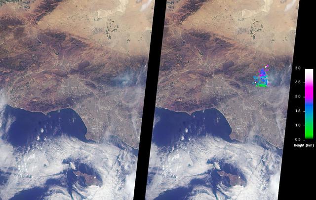
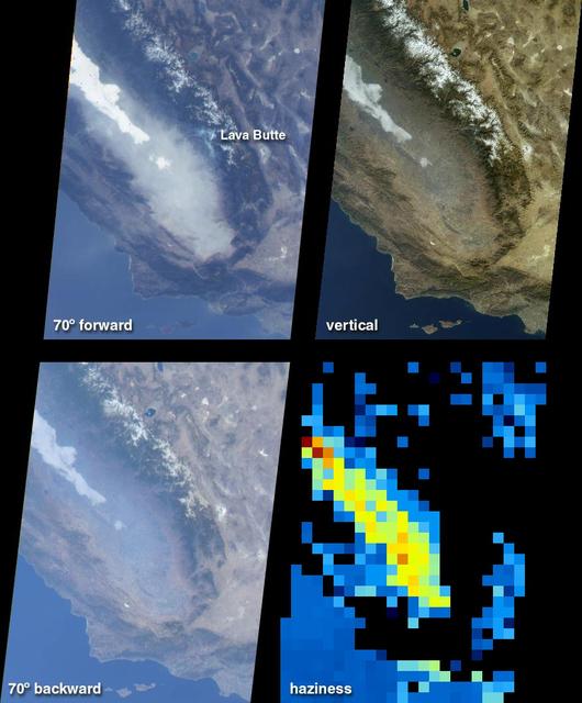
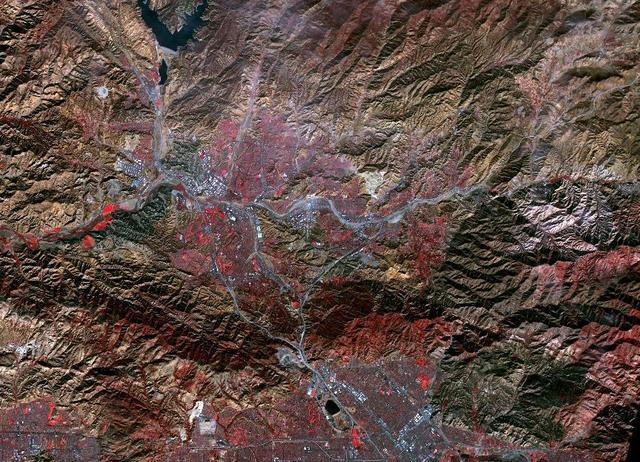
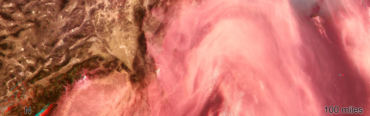
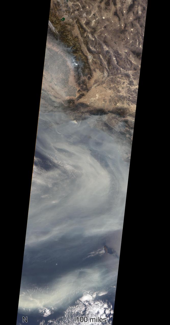
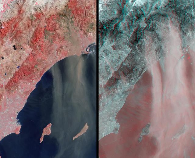
Southern California Wildfires Observed by NASA MISR
The Orion team visits Hurlen Corporation in Santa Fe Springs, CA on Jan. 29, 2014. Part of Batch image transfer from Flickr.
Southern California Braiding
The Orion team visits Hurlen Corporation in Santa Fe Springs, CA on Jan. 29, 2014. Part of Batch image transfer from Flickr.
Southern California Braiding
Large plumes of smoke rising from devastating wildfires burning near Los Angeles and San Diego on Sunday, October 26, 2003, are highlighted in this set of images from NASA Terra spacecraft.
Wildfires Rage in Southern California
With smoke from the Lake Arrowhead area fires streaming in the background, NASA's Ikhana unmanned aircraft heads out on a Southern California wildfires imaging mission.
ED07-0243-36
With smoke from the Lake Arrowhead area fires streaming in the background, NASA's Ikhana unmanned aircraft heads out on a Southern California wildfires imaging mission.
ED07-0243-37
Propulsion Lead Rebekah Lam participates in Perseverance's second trajectory correction maneuver at NASA's Jet Propulsion Laboratory in Southern California.  https://photojournal.jpl.nasa.gov/catalog/PIA24194
Propulsion Lead Checks the Tanks
A Beech T-34C flown by NASA Dryden Flight Research Center for mission support descends over the Southern California desert near Edwards Air Force Base.
A Beech T-34C flown by NASA Dryden Flight Research Center for mission support descends over the Southern California desert near Edwards Air Force Base
NASA's 2017 astronaut candidates toured aircraft hangar at Armstrong Flight Research Center, in Southern California (L to R) Jenni Sidey-Gibbons, Raja Chari, Loral O'Hara, Jasmin Moghbeli, Jonny Kim and Jessica Watkins look inside the engine nozzle of an F-15 jet.  The F-15 will fly in tandem with the X-59 QueSST during early flight test stages for the X-59 development.
Astronauts Look in F-15 Nozzle at Armstrong Flight Research Center
This still from an animation shows, in exaggerated terms, how the surface of the southern Central Valley of California deformed from the period 2007 to 2011.
InSAR Measurements of Subsidence in California Central Valley June 2007--December 2010
This illustration features images of southern California and southwestern Nevada acquired by NASA Terra satellite on January 3, 2001 Terra orbit 5569.
Fog and Haze in California San Joaquin Valley
A magnitude 6.0 earthquake struck southern Napa county northeast of San Francisco, California, on Aug. 24, 2014. NASA satellite data reveal ground defomation.
NASA Analyses of Global Positioning System Data and Italian Radar Satellite Data Reveal Napa Quake Ground Deformation
The quick dry-out of vegetation in Southern California this year is depicted in this pair of images from the Moderate Resolution Imaging Spectroradiometer MODIS sensor on NASA Aqua spacecraft.
MODIS Satellite See Double Jeopardy for Socal Fire Season
The October 2007 wildfires, including the Witch Wildland fire, plagued southern California and were some of the worst on record. Image from NASA Terra satellite.
Witch Wildland Fire, California
Scaled Composites' Proteus aircraft and an F/A-18 Hornet from NASA's Dryden Flight Research Center at Mojave Airport in Southern California.  The unique tandem-wing Proteus was the testbed for a series of UAV collision-avoidance flight demonstrations. An Amphitech 35GHz radar unit installed below Proteus' nose was the primary sensor for the Detect, See and Avoid tests. NASA Dryden's F/A-18 Hornet was one of many different aircraft used in the tests.
Scaled Composites' Proteus aircraft and an F/A-18 Hornet from NASA's Dryden Flight Research Center at Mojave Airport in Southern California.
Scaled Composites' unique tandem-wing Proteus was the testbed for a series of UAV collision-avoidance flight demonstrations. An Amphitech 35GHz radar unit installed below Proteus' nose was the primary sensor for the Detect, See and Avoid tests.
Proteus in flight over Southern California
While the Thomas fire in Ventura County, CA is the largest and most destructive, several other smaller fires burned in the Los Angeles area. The Creek fire destroyed 123 buildings and consumed over 15,000 acres. The smaller Rye fire burned 6,000 acres and destroyed 9 structures. The image was acquired December 17, 2017, covers an area of 9.7 by 13.5 kilometers, and is located at 34.4 degrees north, 118.5 degrees west.  https://photojournal.jpl.nasa.gov/catalog/PIA22149
Creek and Rye Fires, Southern California
NASA Administrator Bill Nelson addresses participants during a climate roundtable at the agency's Jet Propulsion Laboratory in Southern California on Oct. 14, 2021.  https://photojournal.jpl.nasa.gov/catalog/PIA24904
NASA Administrator Bill Nelson Climate Roundtable
The Mars 2020 navigation team celebrates Perseverance's nominal, or successful, trajectory correction maneuver in the Mission Support Area at NASA's Jet Propulsion Laboratory in Southern California.  https://photojournal.jpl.nasa.gov/catalog/PIA24192
Celebrating a Good Day in Space
A front-facing portrait of VITAL (Ventilator Intervention Technology Accessible Locally), a ventilator designed and built by NASA's Jet Propulsion Laboratory in Southern California.  https://photojournal.jpl.nasa.gov/catalog/PIA23775
Front-Facing View of VITAL
Data from the Multi-angle Imaging SpectroRadiometer (MISR) instrument aboard NASA's Terra satellite was used to produce this stereo anaglyph of the Woolsey Fire in southern California on Nov. 11, 2018. It shows a three-dimensional view of the smoke plume -- visible through red-blue 3D glasses.  https://photojournal.jpl.nasa.gov/catalog/PIA22817
NASA's MISR Captures 3D Image of Smoke from California's Woolsey Fire
This image shows the ventilator prototype for coronavirus patients designed and built by NASA's Jet Propulsion Laboratory in Southern California. VITAL (Ventilator Intervention Technology Accessible Locally) is designed to be faster to build and easier to maintain than traditional ventilators, with a fraction of the parts.  https://photojournal.jpl.nasa.gov/catalog/PIA23714
NASA's Coronavirus Ventilator Prototype
The Mars Helicopter team gathers for a group photo at NASA's Jet Propulsion Laboratory in Southern California on Dec. 3, 2018. Holding a full-size model of the helicopter, named Ingenuity, is MiMi Aung, the project manager at JPL.  https://photojournal.jpl.nasa.gov/catalog/PIA22649
Mars Helicopter Team
On May 30, 2013, NASA Terra spacecraft acquired this image of the largest solar plant of its kind in the world started producing power in southern California Mojave Desert near the Nevada border.
Ivanpah Solar Energy Plant, California
Smoke from multiple wildfires burning in Southern California in October, 2007, can be seen in this false-color image from the Atmospheric Infrared Sounder AIRS on NASA Aqua satellite.
Swirls of Smoke and Dust Blow Out to Sea
San Joaquin, the name given to the southern portion of California vast Central Valley, as shown in this image acquired by NASA Shuttle Radar Topography Mission SRTM on February 16, 2000.
SRTM Perspective View with Landsat Overlay: San Joaquin Valley, California
Extensive and persistent rains between Jan. 24 and Jan. 27, 2013, significantly increased soil moisture and enhanced vegetation growth in Southern California based on data from NASA Aqua spacecraft and ISRO Oceansat-2 satellite.
Satellites See Double Jeopardy for Socal Fire Season
NASA's 2017 astronaut candidates (L to R) Zena Cardman, Loral O'Hara, Frank Rubio, Jonny Kim, Raja Chari practice flying in an X-59 QueSST simulator at Armstrong Flight Research Center, in Southern California. The low boom flight demonstrator, X-59, being built at Lockheed Martin and was designed to fly at supersonic speeds over land without the loud noise of breaking the sound barrier and disturbing communities.
Astronauts Pilot X-59 Simulator at Armstrong Flight Research Center
NASA's 2017 astronaut candidates toured aircraft hangar at Armstrong Flight Research Center, in Southern California where Crew Chief Tom Grindle talks with (L to R) Jessica Watkins and Raja Chari near engine nozzle of F-15 jet. The F-15 will fly in tandem with the X-59 QueSST during early flight test stages for the X-59 development.
Astronauts Tour Aircraft Hangar at Armstrong Flight Research Center
NASA's 2017 astronaut candidates toured aircraft hangar at Armstrong Flight Research Center, in Southern California (L to R) Raja Chari, Jenni Sidey-Gibbons, Loral O'Hara, Jasmin Moghbeli, Jonny Kim and Jessica Watkins look inside the engine nozzle of an F-15 jet. The F-15 will fly in tandem with the X-59 QueSST during early flight test stages for the X-59 development.
Astronauts Look in F-15 Nozzle at Armstrong Flight Research Center
NASA's 2017 astronaut candidate Kayla Barron practices flying in an X-59 QueSST simulator at Armstrong Flight Research Center, in Southern California. The low boom flight demonstrator, X-59, being built at Lockheed Martin and was designed to fly at supersonic speeds over land without the loud noise of breaking the sound barrier and disturbing communities.
Astronaut Pilots X-59 Simulator at Armstrong Flight Research Center
NASA's 2017 astronaut candidates (L to R) Jenni Sidey-Gibbons, Jessica Watkins and Joshua Kutryk practice flying in an F-18 aircraft cockpit simulator at Armstrong Flight Research Center, in Southern California. The F-18's are flown for research support and pilot proficiency. Currently, the F-18 is conducting supersonic research in support of the X-59 QueSST overall mission.
Astronauts Pilot F-18 Simulator at Armstrong Flight Research Center
NASA's 2017 astronaut candidates (L to R) Jessica Watkins and Jenni Sidey-Gibbons practice flying in an F-18 aircraft cockpit simulator at Armstrong Flight Research Center, in Southern California. The F-18's are flown for research support and pilot proficiency. Currently, the F-18's are being used to conduct supersonic research in support of the X-59 QueSST overall mission.
Astronauts Pilot F-18 Simulator at Armstrong Flight Research Center
NASA's 2017 astronaut candidates toured aircraft hangar at Armstrong Flight Research Center, in Southern California where (L to R) Loral O'Hara, Jenni Sidey-Gibbons and Raja Chari look inside the engine nozzle of an F-15 jet. The F-15 will fly in tandem with the X-59 QueSST during early flight test stages for the X-59 development.
Astronauts Look in F-15 Nozzle at Armstrong Flight Research Center
NASA's 2017 astronaut candidates toured aircraft hangar at Armstrong Flight Research Center, in Southern California where they checked out a F-15 cockpit. The center is using its fleet of supersonic research support aircraft for sonic boom research, including the F-15, which will fly in tandem with the X-59 QueSST during early flight test stages, and the F-18, which is conducting supersonic research in support of the overall mission.
2017 Astronauts Tour Hangar at Armstrong Flight Research Center
NASA’s 2017 astronaut candidates (L to R)  Jonny Kim and Raja Chari practice flying in an X-59 QueSST simulator at Armstrong Flight Research Center, in Southern California. The low boom flight demonstrator, X-59, being built at Lockheed Martin and was designed to supersonically over land without the loud noise of breaking the sound barrier and disturbing communities.
Astronauts Pilot X-59 Simulator at Armstrong Flight Research Center
NASA's 2017 astronaut candidate Matthew Dominick practices flying in the X-57 aircraft simulator at Armstrong Flight Research Center in Southern California. Starting with the fuselage of a Tecnam P20067T, the X-57 Maxwell electric propulsion airplane is being built from ideas being researched that could lead to the development of electric propulsion-powered aircraft, which would be quieter, more efficient and environmentally friendly than today's commuter aircraft.
Astronaut Pilots X-57 Simulator at Armstrong Flight Research Center
NASA’s 2017 astronaut candidates toured aircraft hangar at Armstrong Flight Research Center, in Southern California where they checked out a F-15 cockpit. The center is using its fleet of supersonic research support aircraft for sonic boom research, including the F-15, which will fly in tandem with the X-59 QueSST during early flight test stages, and the F-18, which is conducting supersonic research in support of the overall mission.
2017 Astronauts Tour Hangar at Armstrong Flight Research Center
For the fourth consecutive year, Irvine's University High School won the Southern California regional round of the National Science Bowl, hosted by JPL. The team, including coach David Knight (lower right), paused for a group shot after their victory on March 20, 2021.  https://photojournal.jpl.nasa.gov/catalog/PIA23730
University High School Science Bowl Team
Morale was high as the Mars Helicopter team gathered for a group photo on Dec. 3, 2018, at NASA's Jet Propulsion Laboratory in Southern California. The helicopter, named Ingenuity, is a technology demonstration to test the first powered flight on another world. The helicopter will ride to Mars attached inside the belly of the Perseverance rover.  https://photojournal.jpl.nasa.gov/catalog/PIA22650
Mars Helicopter Team Is Ready to Fly
Some of the dozens of engineers involved in creating a ventilator prototype specially targeted to coronavirus disease patients at NASA's Jet Propulsion Laboratory in Southern California. Called VITAL (Ventilator Intervention Technology Accessible Locally), the prototype was created in 37 days in March and April 2020.  https://photojournal.jpl.nasa.gov/catalog/PIA23713
NASA-JPL Ventilator Prototype Team Members
An April 5, 2022, virtual video event is seen on a monitor in the Mars Perseverance rover control room at NASA's Jet Propulsion Laboratory in Southern California. Team members interacted with students who have overcome academic obstacles, and the students received personalized messages from the rover on Mars.  https://photojournal.jpl.nasa.gov/catalog/PIA25273
Students Honored in NASA You've Got Perseverance Event
The Space Shuttle Endeavour, mounted securely atop one of NASA's modified Boeing 747 Shuttle Carrier Aircraft, left NASA's Dryden Flight Research Center at Edwards Air Force Base in Southern California at sunrise on Friday, June 28.
The Space Shuttle Endeavour, mounted securely atop one of NASA's modified Boeing 747 Shuttle Carrier Aircraft, left NASA's Dryden Flight Research Center at Edwards Air Force Base in Southern California at sunrise on Friday, June 28
Scaled Composites' Proteus aircraft with an F/A-18 Hornet and a Beechcraft KingAir from NASA's Dryden Flight Research Center during a low-level flyby at Mojave Airport in Southern California.  The unique tandem-wing Proteus was the testbed for a series of UAV collision-avoidance flight demonstrations. An Amphitech 35GHz radar unit installed below Proteus' nose was the primary sensor for the Detect, See and Avoid tests.
Scaled Composites' Proteus aircraft with an F/A-18 Hornet and a Beechcraft KingAir from NASA's Dryden Flight Research Center during a low-level flyby at Mojave Airport in Southern California.
Commercial Crew astronauts Chris Ferguson, Nicole Mann and Eric Boe recently toured spacecraft testing facilities in El Segundo and Huntington Beach, Calif. All three astronauts will fly on Boeing’s CST-100 Starliner in an upcoming crew flight test to the International Space Station. Environmental qualification testing in El Segundo ensures the spacecraft can withstand the extreme environments of space. Structural testing in Huntington Beach confirms the spacecraft can withstand the pressures it will experience during flight.
CCP Astronauts Tour Test Facilities in Southern California
Data from NASA's ECOSTRESS (Ecosystem Spaceborne Thermal Radiometer Experiment on Space Station) instrument aboard the International Space Station shows three wildfires burning in the mountains east and southeast of the Los Angeles area on Sept. 10, 2024.  The Bridge Fire started Sept. 8 in the Angeles National Forest during an intense heat wave that blanketed the area for about a week. As of Sept. 13, the fire was only 3% contained. The Line Fire started Sept. 5 in Highland, within San Bernardino County, and spread toward the mountain communities of Running Springs and Big Bear. After more than a week of battling the blaze, firefighters had the conflagration 21% contained. The Airport Fire ignited Sept. 9 in the foothills of the Santa Ana Mountains east of the Orange County city of Irvine and spread into Riverside County. As of Sept. 13, it was 8% contained.  The ECOSTRESS instrument measures the temperature of the land rather than air temperatures that most people are familiar with in weather forecasts. Bright white spots in the active fire areas in the visual above indicate a land surface temperature of over 300 degrees Fahrenheit (149 degrees Celsius). Dark red represents areas closer to 100 F (38 C).  https://photojournal.jpl.nasa.gov/catalog/PIA26187
Southern California Wildfires Captured by NASA's ECOSTRESS
Commercial Crew astronauts Chris Ferguson, Nicole Mann and Eric Boe recently toured spacecraft testing facilities in El Segundo and Huntington Beach, Calif. All three astronauts will fly on Boeing’s CST-100 Starliner in an upcoming crew flight test to the International Space Station. Environmental qualification testing in El Segundo ensures the spacecraft can withstand the extreme environments of space. Structural testing in Huntington Beach confirms the spacecraft can withstand the pressures it will experience during flight.
CCP Astronauts Tour Test Facilities in Southern California
This image from NASA Terra satellite of Diamond Valley Lake Reservoir, near the city of Hemet in Riverside County, billed as the largest earthworks construction project in U.S.history.
Watching the Creation of Southern California Largest Reservoir
This anaglyph from the MISR instrument aboard NASA Terra spacecraft shows Santa Ana winds swept large amounts of dust and ash across the skies of San Diego and over the Pacific Ocean. 3D glasses are necessary to view this image.
Airborne Dust and Ash over Southern California
Brad Flick, center director at NASA’s Armstrong Flight Research Center in Edwards, California, presents a 2024 NASA College Scholarship Award to Sabrina Redifer. From left to right are Sabrina Redifer’s parents Matthew and Saynne Redifer, Flick, Sabrina Redifer, and her sister Samantha Redifer.
Southern California Student Wins NASA Scholarship
Altus II aircraft flying over southern California desert
EC98-44684-1
Altus II aircraft flying over southern California desert
EC98-44684-2
Altus II aircraft flying over southern California desert
EC98-44684-3
Matt Smith, flight director for the second Mars 2020 mission trajectory correction maneuver (TCM-2), studying the screens at NASA's Jet Propulsion Laboratory in Southern California. TCMs are a series of planned adjustments to put the rover on the correct path to land on Mars.  https://photojournal.jpl.nasa.gov/catalog/PIA24193
All Systems Go for Planned Course Correction
The Multi-angle Imaging SpectroRadiometer (MISR) instrument on NASA's Terra satellite took this image of the Woolsey Fire in southern California on Nov. 11, 2018. The Woolsey Fire had charred more than 90,000 acres as of Nov. 12, 2018, and was 20-percent contained at that time.  https://photojournal.jpl.nasa.gov/catalog/PIA22818
NASA's MISR Sees California's Woolsey Fire From Space
iss055e023287 (April 15, 2018) --- Mexico, Baja California and the southern coast of the state of California are pictured as the International Space Station orbited above the Pacific Ocean. When the SpaceX Dragon cargo craft returns to Earth after completing its mission at the station it splashes down in the Pacific Ocean a few hundred miles off the coast of southern California and Baja California.
iss055e023287
The Advanced Rapid Imaging and Analysis (ARIA) team at NASA's Jet Propulsion Laboratory in Pasadena, California, created this map depicting areas that are likely damaged as a result of the recent major earthquakes in Southern California. The color variation from yellow to red indicates increasingly more significant surface change, or damage. The map covers an area of 155 by 186 miles (250 by 300 kilometers), shown by the large red polygon. Each pixel measures about 33 yards (30 meters) across.  To make the map, the team used synthetic aperture radar (SAR) images from the European Space Agency's Copernicus Sentinel-1 satellites from before and after the sequence of quakes — July 4, 2019 and July 10, 2019 respectively. The map may be less reliable over vegetated areas but can provide useful guidance in identifying damaged areas.  https://photojournal.jpl.nasa.gov/catalog/PIA23354
NASA's ARIA Team Maps California Quake Damage
Some of the dozens of engineers involved in creating a ventilator prototype specially targeted to coronavirus disease patients at NASA's Jet Propulsion Laboratory in Southern California. Called VITAL (Ventilator Intervention Technology Accessible Locally), the prototype was created in 37 days in March and April 2020.  Left to right, standing: Shaunessy Grant, Michael Johnson, Dave Van Buren, Michelle Easter.  Left to right, kneeling: Brandon Metz, Patrick Degrosse.  https://photojournal.jpl.nasa.gov/catalog/PIA23891
VITAL Team Gives a Thumbs Up
Engineers at NASA's Jet Propulsion Laboratory in Southern California prepare to ship a prototype ventilator for coronavirus patients to the Icahn School of Medicine at Mount Sinai in New York.      VITAL (Ventilator Intervention Technology Accessible Locally) is designed to be faster to build and easier to maintain than traditional ventilators, with a fraction of the parts. JPL engineers created the prototype specially targeted at COVID-19 patients in 37 days in March and April 2020.  https://photojournal.jpl.nasa.gov/catalog/PIA23716
Shipping NASA's Coronavirus Ventilator Prototype