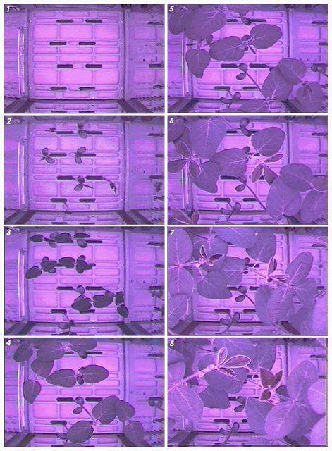
This composite image shows soybean plants growing in the Advanced Astroculture experiment aboard the International Space Station during June 11-July 2, 2002. DuPont is partnering with NASA and the Wisconsin Center for Space Automation and Robotics (WCSAR) at the University of Wisconsin-Madison to grow soybeans aboard the Space Station to find out if they have improved oil, protein, carbohydrates or secondary metabolites that could benefit farmers and consumers. Principal Investigators: Dr. Tom Corbin, Pioneer Hi-Bred International Inc., a Dupont Company, with headquarters in Des Moines, Iowa, and Dr. Weijia Zhou, Wisconsin Center for Space Automation and Robotics (WCSAR), University of Wisconsin-Madison.
This is a photo of soybeans growing in the Advanced Astroculture (ADVASC) Experiment aboard the International Space Station (ISS). The ADVASC experiment was one of the several new experiments and science facilities delivered to the ISS by Expedition Five aboard the Space Shuttle Orbiter Endeavor STS-111 mission. An agricultural seed company will grow soybeans in the ADVASC hardware to determine whether soybean plants can produce seeds in a microgravity environment. Secondary objectives include determination of the chemical characteristics of the seed in space and any microgravity impact on the plant growth cycle. Station science will also be conducted by the ever-present ground crew, with a new cadre of controllers for Expedition Five in the ISS Payload Operations Control Center (POCC) at NASA's Marshall Space Flight Center in Huntsville, Alabama. Controllers work in three shifts around the clock, 7 days a week, in the POCC, the world's primary science command post for the Space Station. The POCC links Earth-bound researchers around the world with their experiments and crew aboard the Space Station.
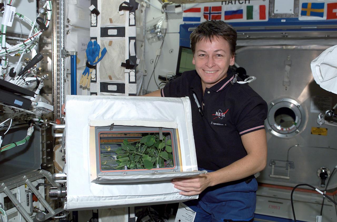
Expedition Five crewmember and flight engineer Peggy Whitson displays the progress of soybeans growing in the Advanced Astroculture (ADVASC) Experiment aboard the International Space Station (ISS). The ADVASC experiment was one of the several new experiments and science facilities delivered to the ISS by Expedition Five aboard the Space Shuttle Orbiter Endeavor STS-111 mission. An agricultural seed company will grow soybeans in the ADVASC hardware to determine whether soybean plants can produce seeds in a microgravity environment. Secondary objectives include determination of the chemical characteristics of the seed in space and any microgravity impact on the plant growth cycle. Station science will also be conducted by the ever-present ground crew, with a new cadre of controllers for Expedition Five in the ISS Payload Operations Control Center (POCC) at NASA's Marshall Space Flight Center in Huntsville, Alabama. Controllers work in three shifts around the clock, 7 days a week, in the POCC, the world's primary science command post for the Space Station. The POCC links Earth-bound researchers around the world with their experiments and crew aboard the Space Station.
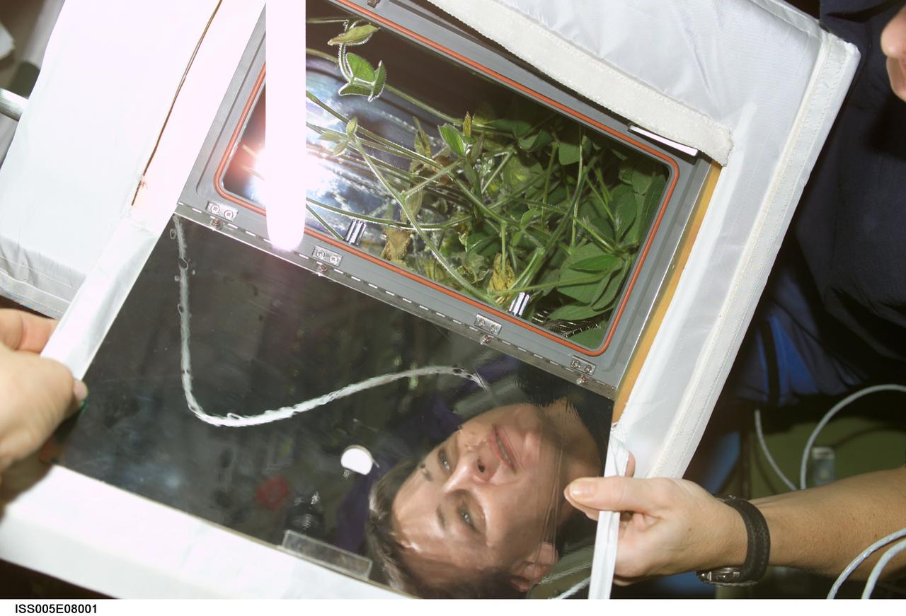
ISS005-E-08001 (18 July 2002) --- Astronaut Peggy A. Whitson, Expedition Five flight engineer, works with the Advanced Astroculture soybean plant growth experiment in the Destiny laboratory on the International Space Station (ISS).
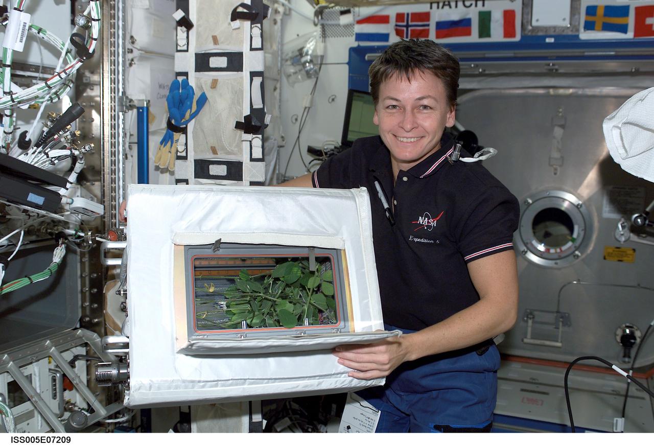
ISS005-E-07209 (10 July 2002) --- Astronaut Peggy A. Whitson, Expedition Five NASA ISS science officer, holds the Advanced Astroculture soybean plant growth experiment in the Destiny laboratory on the International Space Station (ISS).
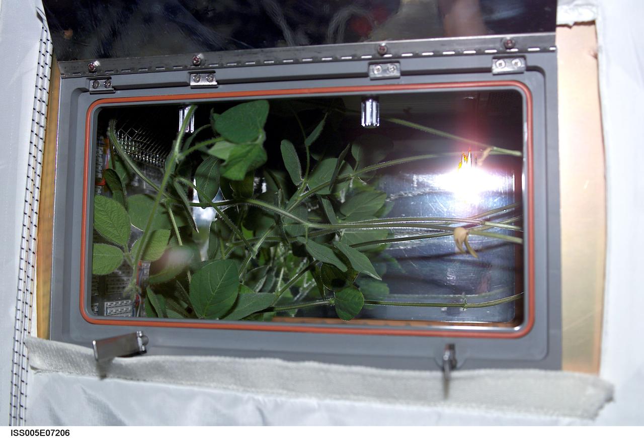
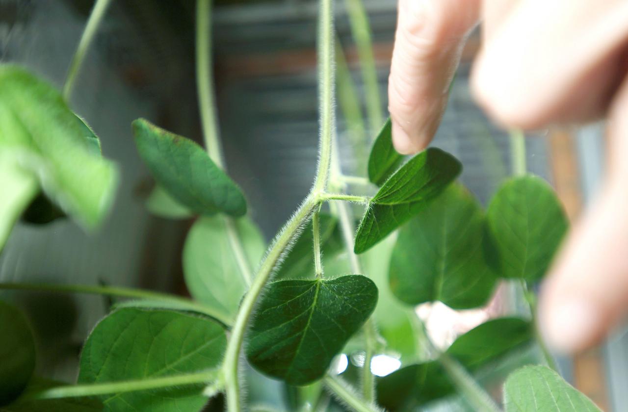
ISS005-E-07206 (10 July 2002) --- A close-up view of the Advanced Astroculture soybean plant growth experiment in the Destiny laboratory on the International Space Station (ISS).
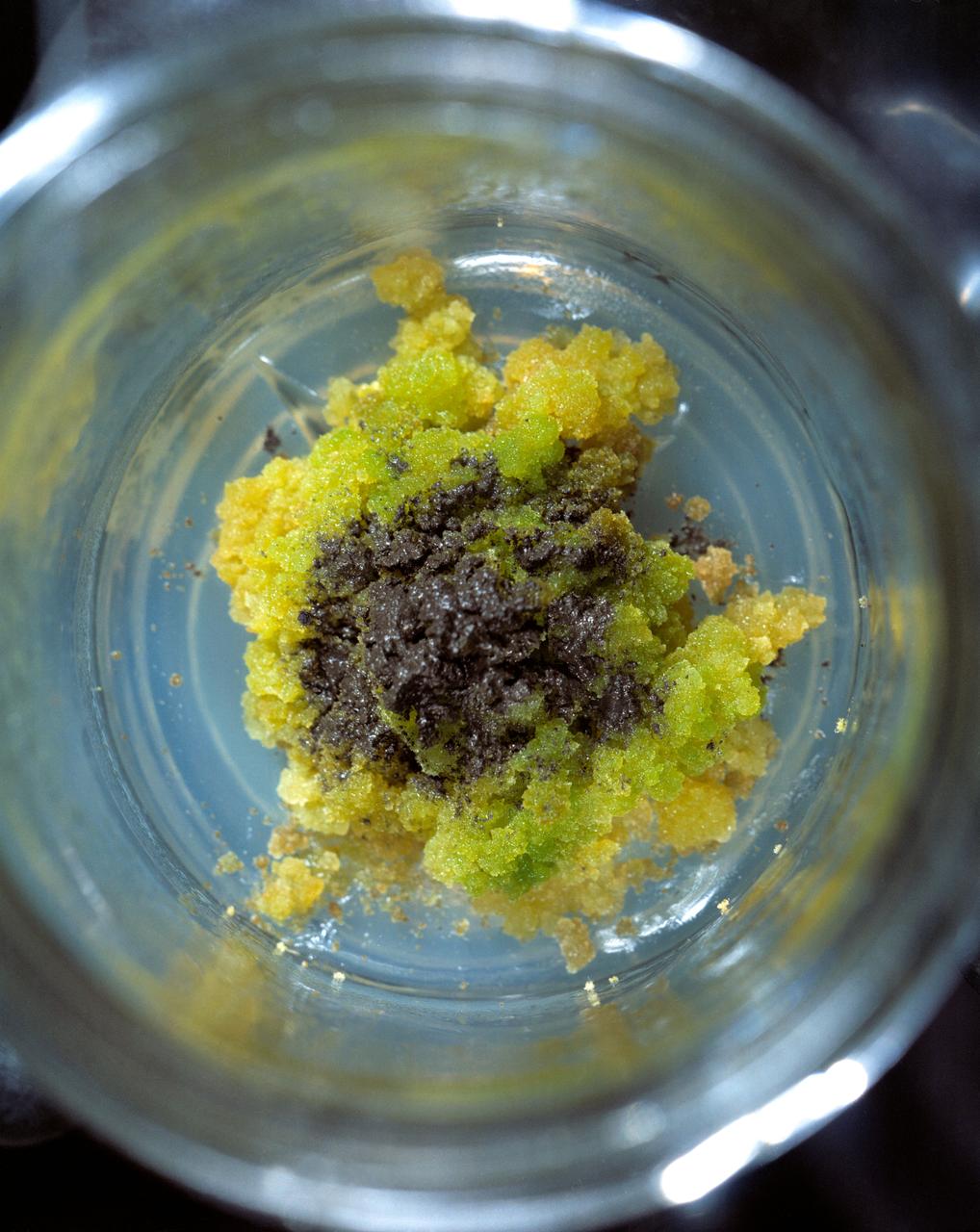
S71-51315 (1 Oct. 1971) --- A close-up view of soybean tissue culture growing in a synthetic medium and Apollo 15 lunar material. Note the greening occurring in areas in contact with the soil particles.
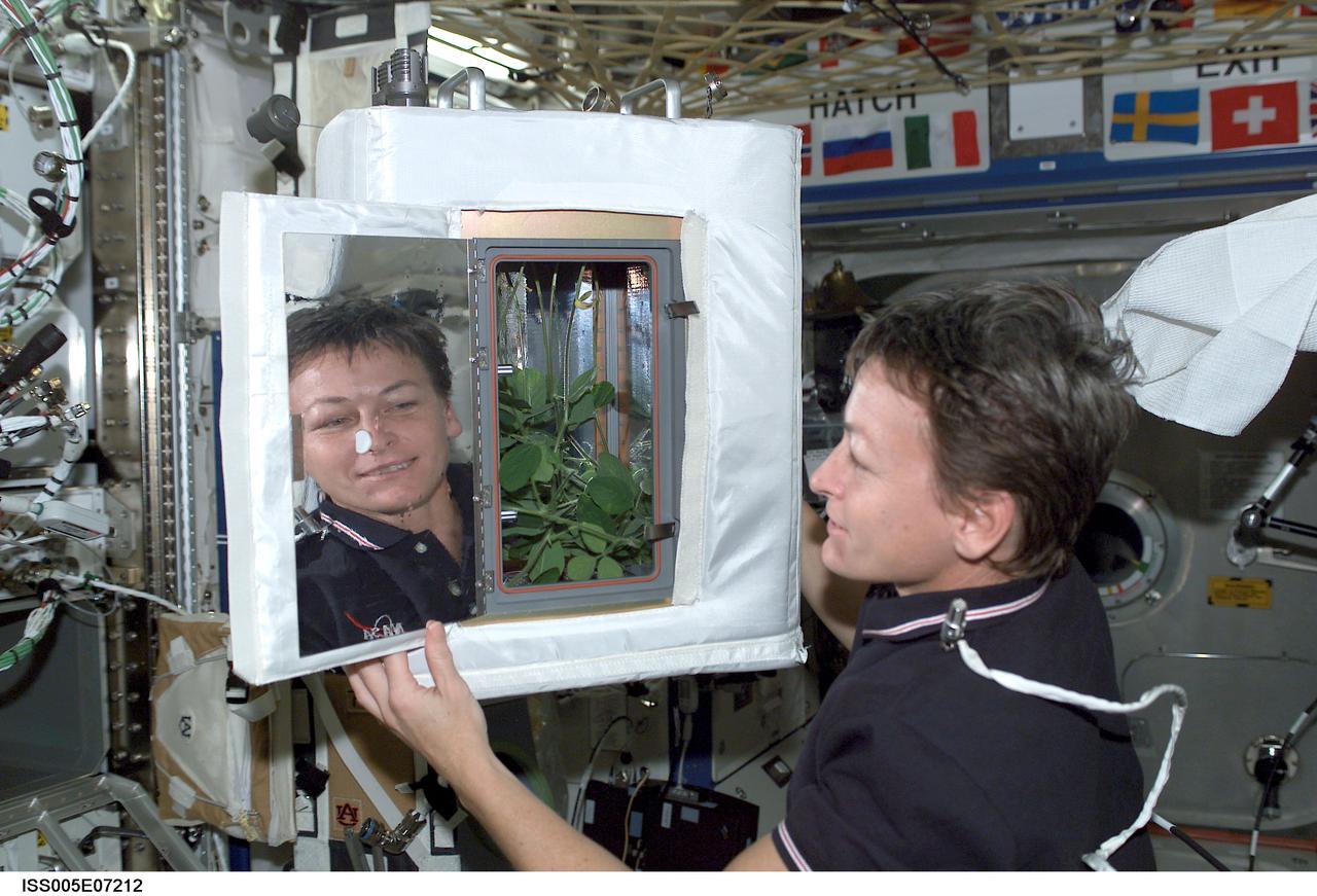
ISS005-E-07212 (10 July 2002) --- NASA Astronaut Peggy Whitson, Expedition 5 International Space Station (ISS) science officer, looks at the Advanced Astroculture (ADVASC) Soybean plant growth experiment as part of Expediting the Process of Experiments to the Space Station (EXPRESS) Rack 4 located in the U.S. Laboratory Destiny.
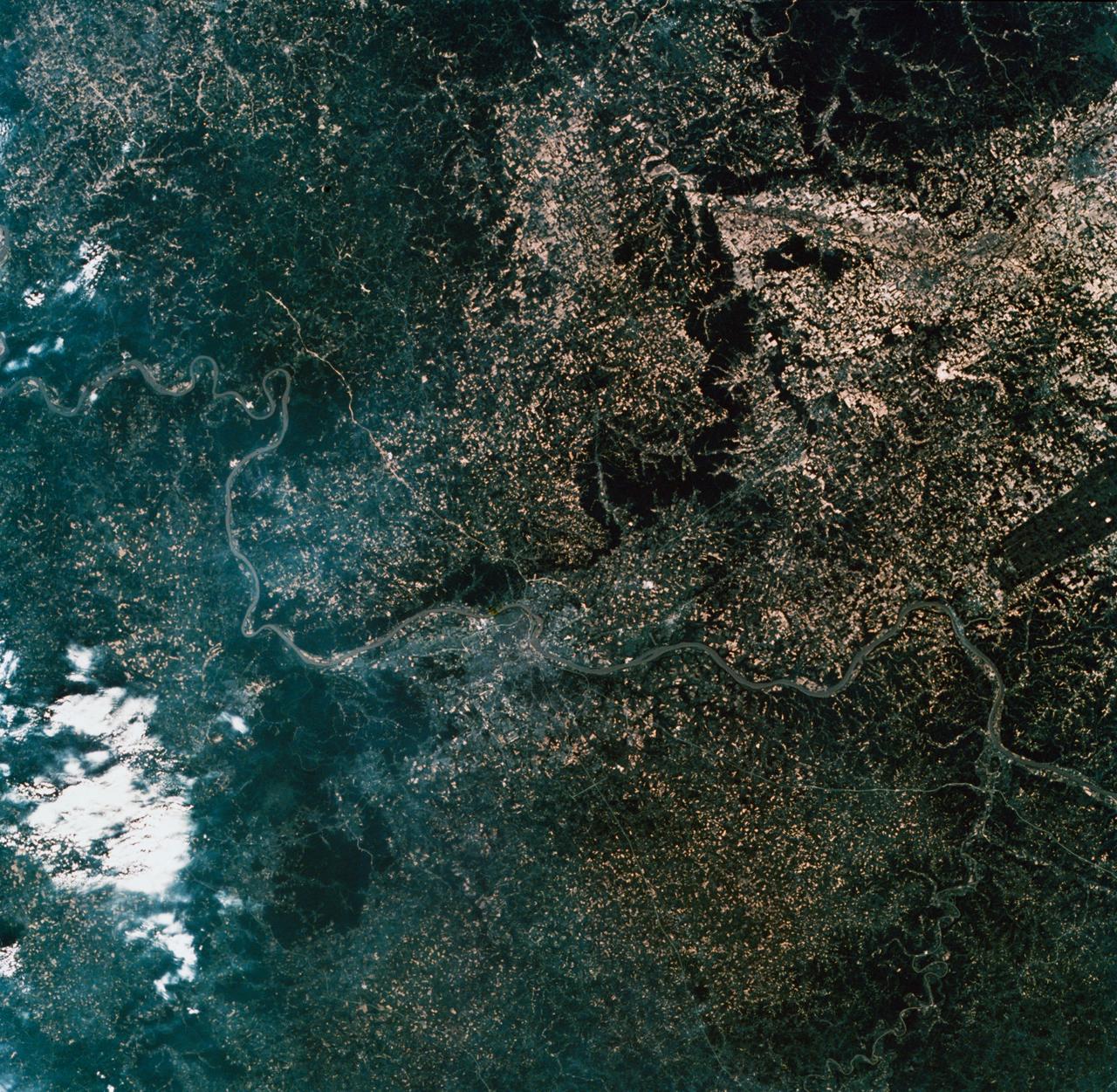
SL2-10-260 (22 June 1973) --- The meandering Ohio River bisecting this image is the border between Kentucky and Indiana. Louisville, KY (38.5N, 86.0W) on the south shore, is the main city seen in this predominately agricultural region where much of the native hardwood forests have been preserved in the hilly terrain. The main crops in this region include corn, alfalfa, wheat and soybeans. The dark rectangle in south Indiana near the river is The U.S. Army's Jefferson Proving Ground. Photo credit: NASA

Before new bio-based synthetic oils were added to Armstrong vehicles, the old oil was drained and sent to a lab for analysis to compare to the new lubricant.

A new bio-based synthetic engine oil is added to one of the vehicles that Armstrong is using to assist in performance testing of the new product.

Scott Rogers pours a new bio-based synthetic engine oil into one of the vehicles that Armstrong is using to assist in the performance testing of the new product.
Dr. Weijia Zhou, director of the Wisconsin Center for Space Automation and Robotics at the University of Wisconsin-Madison, inspects the Advanced Astroculture(tm) plant growth unit before its first flight last spring. Coating technology is used inside the miniature plant greenhouse to remove ethylene, a chemical produced by plant leaves that can cause plants to mature too quickly. This same coating technology is used in a new anthrax-killing device. The Space Station experiment is managed by the Space Product Development Program at NASA's Marshall Space Flight Center in Huntsville, Ala. DuPont is partnering with NASA and the Wisconsin Center for Space Automation and Robotics (WCSAR) at the University of Wisconsin-Madison to grow soybeans aboard the Space Station to find out if they have improved oil, protein, carbohydrates or secondary metabolites that could benefit farmers and consumers. Principal Investigators: Dr. Tom Corbin, Pioneer Hi-Bred International Inc., a Dupont Company, with headquarters in Des Moines, Iowa, and Dr. Weijia Zhou, Wisconsin Center for Space Automation and Robotics (WCSAR), University of Wisconsin-Madison.
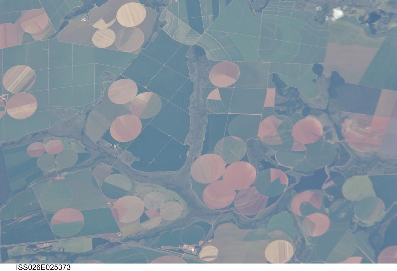
ISS026-E-025373 (10 Feb. 2011) --- Agricultural fields near Perdizes, Minas Gerais, Brazil are featured in this image photographed by an Expedition 26 crew member on the International Space Station. This detailed photograph illustrates diverse agricultural landscape patterns in the western part of the Brazilian State of Minas Gerais. Perhaps most widely known for its mineral wealth, Minas Gerais is also a large agricultural producer in Brazil. The fields in the image are located to the southwest of the city of Perdizes, which means “partridges” in Portuguese. A mix of regularly-gridded polygonal fields, and circular center-pivot fields, marks the human land use of the region. Small tributary streams (and their adjacent floodplains) of the Araguari River extend like fingers throughout the agricultural landscape. The visual diversity of field forms is matched by the variety of crops produced here: sunflowers, wheat, potatoes, coffee, rice, soybeans, and corn are among the agricultural products of the region. While the Northern Hemisphere is still in the grip of winter, crops are growing in the Southern Hemisphere as indicated by the many green fields in the image. Fallow fields—fields not in active agricultural use—display the violet, reddish to light tan soils common to this part of Brazil. The darker soils are often rich in iron and aluminum oxides, and are typical of highly weathered soil material that forms in hot, humid climates.
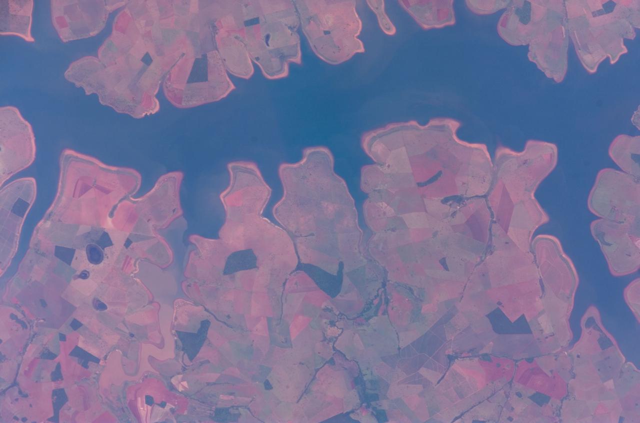
ISS016-E-011999 (22 Nov. 2007) --- Sao Simao Reservoir, Brazil is featured in this image photographed by an Expedition 16 crewmember on the International Space Station (ISS). The Sao Simao reservoir, near the confluence of the Rio Paranaiba and Rio Verde in Brazil, is the featured subject in a milestone image of Earth. This colorful, patchwork image is the 300,000th image of Earth downlinked from the space station. There are now over 745,000 images of Earth taken by astronaut crews, beginning with the Mercury missions in 1961 and continuing to the present day on the ISS. The Sao Simao reservoir is located on the border between the states of Goias and Minas Gerais (near the geographic coordinates of 18.7S 50.4W). Though the town of Sao Simao was founded around 1935, major growth occurred when the hydroelectric power plant and dam were built - forming the reservoir -- in 1975. The reservoir is part of a major navigation link that allows transport of goods and commerce between central Brazil, the Prata River and the South Atlantic. With 600,000 square kilometers of surface area, the reservoir also serves as a tourist destination for fishing, swimming and boating. In addition to hydroelectric power production, the economy of the region is based in agribusiness. The image highlights agricultural fields of various kinds and in different stages of cultivation. The major commodities include corn, soybeans, sesame seeds, sugarcane, beans, manioc, coffee and meat production.
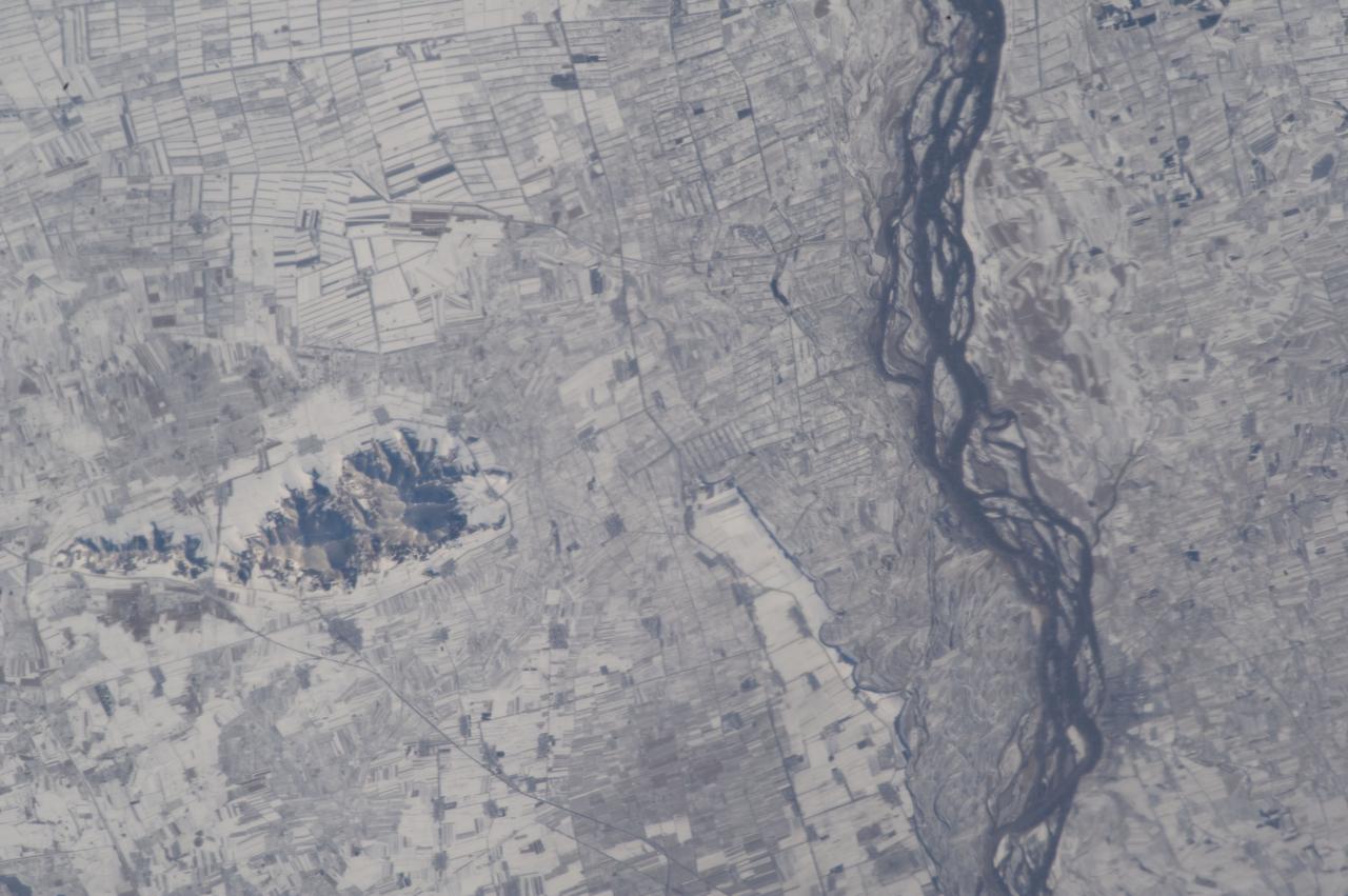
ISS033-E-022759 (18 Nov. 2012) --- Agricultural fields under snow in easternmost China are featured in this image photographed by an Expedition 33 crew member on the International Space Station. This photograph highlights many hundreds of rectangular fields on either side of a 36-kilometer stretch of the braided Songhua River (right). Some fields are easier to see than others due to the winter snow cover. The Songhua joins with the Amur R. about 40 kilometers downstream, at the border with Russia?s Far East. Numerous villages also appear as small gray polygons. Broad floodplains can be recognized on both sides of the river, occupied by fewer fields by almost no villages. The town of Suibing stands out as a larger gray patch on the banks of the river. A significant 300-meter-high hill south of the river throws midmorning shadows (left). The region is one of the most heavily cultivated in northeastern China with corn, soybeans, and sorghum being major crops. The areas of varying whiteness of the snow cover may correlate with zones of different crops and forest cover (for example, on the hill in the center part of the image). The degree to which fallow fields are cleared of vegetation may also affect the apparent snow brightness.

ISS038-E-023651 (26 Dec. 2013) --- Lake Sharpe near Lower Brule, South Dakota is featured in this image photographed by an Expedition 38 crew member on the International Space Station. The Missouri River rises in the Rocky Mountains of western Montana, and flows generally to the southeast for approximately 3,767 kilometers (2,341 miles) to its confluence with the Mississippi River north of St. Louis, Missouri -- making it the longest river in North America. The river does not follow a straight southeasterly course along this distance, but includes may meander bends such as illustrated in this photograph. This particular bend is occupied by Lake Sharpe, an approximately 130-kilometer (80 miles) long reservoir formed behind the Big Bend Dam on the Missouri River. The lake surface is frozen and covered with snow, presenting a uniform white appearance in the image. As meander bends develop, they tend to assume a distinctive U-shape when viewed from above. Over time, the river channel can continue to cut into the ends of the "U", eventually bringing them so close together that the river then cuts across the gap to achieve a shorter flow path, essentially short-circuiting or cutting off the meander bend. When this happens and the meander ceases to be part of the active river channel, it may become an oxbow lake. The distance across the narrow neck of land (lower right) associated with this meander near Lower Brule, South Dakota is approximately one kilometer (0.62 miles); however, as the river flow is controlled by the Big Bend Dam downstream, the natural process of meander cutoff has been significantly slowed. The snow cover also highlights circular agricultural fields on the small peninsula within the meander bend. This type of field indicates center-pivot irrigation, where water is distributed from a central point radially outwards using sprinklers to cover the field area. Crops grown here include corn and soybeans according to data from the US Department of Agriculture's CropScape database.
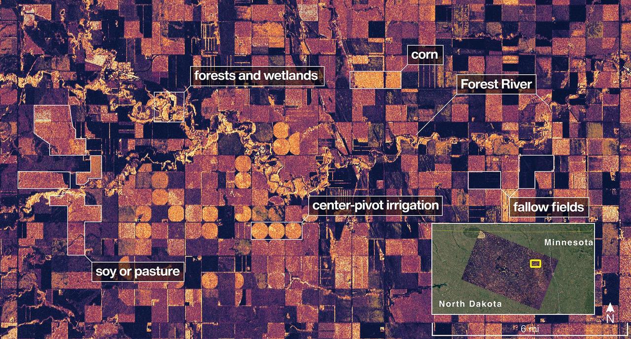
The NISAR (NASA-ISRO Synthetic Aperture Radar) Earth-observing radar satellite's L-band synthetic aperture radar (SAR) system captured an image of a portion of northeastern North Dakota straddling Grand Forks and Walsh counties on Aug. 23, 2025. Produced by scientists on the NISAR science team, the image shows forests and wetlands on the banks of the Forest River meandering through the middle of the frame from west to east and farmland to the north and south. The darker agricultural plots are fallow fields, while the lighter colors represent the presence of pasture or crops, such as soybean and corn. Circular patterns indicate the use of center-pivot irrigation. The satellite is a joint effort between NASA and the Indian Space Research Organisation (ISRO) and is the first satellite to combine L-band and S-band radar systems. The satellite's L-band system, provided by NASA's Jet Propulsion Laboratory in Southern California, uses a 10-inch (25-centimeter) wavelength that enables its signal to penetrate forest canopies and measure soil moisture as well as motion of ice surfaces and land down to fractions of an inch – a key measurement in understanding how the land surface moves before, during, and after earthquakes, volcanic eruptions, and landslides. The NISAR S-band radar, provided by ISRO's Space Applications Centre, uses a 4-inch (10-centimeter) microwave signal that's more sensitive to small vegetation, which makes it effective at monitoring certain types of agriculture and grassland ecosystems. Data used to create the image was collected during NISAR's commissioning phase, when the spacecraft's systems and instruments are powered on and tested. The NISAR mission will begin science operations in November, roughly 90 days after its July 30, 2025, launch from Satish Dhawan Space Centre on India's southeastern coast. Observations from NISAR will benefit humanity by helping researchers around the world better understand changes in our planet's surface, including its ice sheets, glaciers, and sea ice. It also will capture changes in forest and wetland ecosystems and track movement and deformation of our planet's crust by phenomena such as earthquakes, landslides, and volcanic activity. The global and rapid coverage from NISAR will provide unprecedented support for disaster response, producing data to assist in mitigating and assessing damage, with observations before and after catastrophic events available in short time frames. https://photojournal.jpl.nasa.gov/catalog/PIA26615