Spanish Bombs
Los Volcanes Natural Park on Lanzarote in the Spanish Canary Islands is serving as a training ground to prepare for the next mission to the Moon and Mars. NASA and ESA use it for astronaut training and testing Mars Rovers. Astronauts are taught to become effective field geologists and geo-microbiologists in a planetary science context. The image was acquired February 14, 2014, covers an area of 32.7 by 58.5 km, and is located at 29 degrees north, 13.6 degrees west. https://photojournal.jpl.nasa.gov/catalog/PIA23526
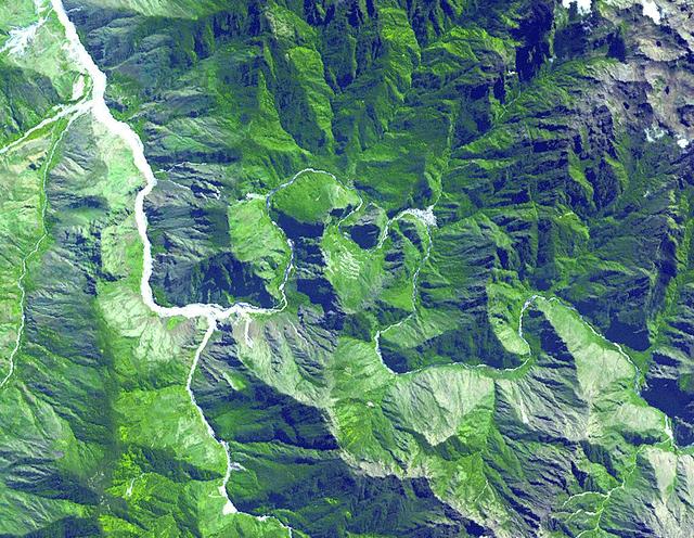
This dramatic view looks west along the Cucharas River Canyon in Colorado toward the 4,152 meter 13,623 ft high Spanish Peaks, in the foothills of the Sangre De Cristo Mountains.

Ana Leon, Solar Orbiter contamination control architect with Airbus Defence and Space, participates in a Spanish Facebook Live event for the Solar Orbiter mission in the Press Site auditorium at NASA’s Kennedy Space Center in Florida on Jan. 29, 2020. Solar Orbiter is an international cooperative mission between ESA (European Space Agency) and NASA. The mission aims to study the Sun, its outer atmosphere and solar wind. The spacecraft will provide the first images of the Sun’s poles. NASA’s Launch Services Program based at Kennedy is managing the launch. The spacecraft has been developed by Airbus Defence and Space. Solar Orbiter will launch in February 2020 aboard a United Launch Alliance Atlas V rocket from Space Launch Complex 41 at Cape Canaveral Air Force Station in Florida.

Teresa Nieves-chinchilla, deputy project scientist at NASA’s Goddard Space Flight Center in Greenbelt, Maryland, participates in a Spanish Facebook Live event for the Solar Orbiter mission in the Press Site auditorium at the agency’s Kennedy Space Center in Florida on Jan. 29, 2020. Solar Orbiter is an international cooperative mission between ESA (European Space Agency) and NASA. The mission aims to study the Sun, its outer atmosphere and solar wind. The spacecraft will provide the first images of the Sun’s poles. NASA’s Launch Services Program based at Kennedy is managing the launch. The spacecraft has been developed by Airbus Defence and Space. Solar Orbiter will launch in February 2020 aboard a United Launch Alliance Atlas V rocket from Space Launch Complex 41 at Cape Canaveral Air Force Station in Florida.
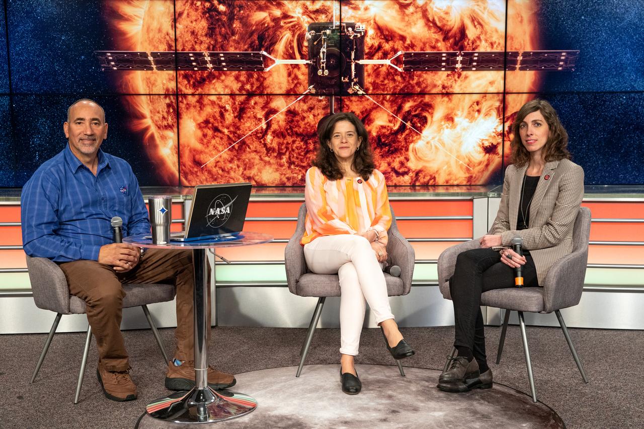
At left, Albert Sierra, Launch Services Program, moderates a Spanish Facebook Live event for the Solar Orbiter mission, with Teresa Nieves-chinchilla, deputy project scientist at NASA’s Goddard Space Flight Center in Greenbelt, Maryland, and Ana Leon, Solar Orbiter contamination control architect with Airbus Defence and Space. The event was held in the Press Site auditorium at the agency’s Kennedy Space Center in Florida on Jan. 29, 2020. Solar Orbiter is an international cooperative mission between ESA (European Space Agency) and NASA. The mission aims to study the Sun, its outer atmosphere and solar wind. The spacecraft will provide the first images of the Sun’s poles. NASA’s Launch Services Program based at Kennedy is managing the launch. The spacecraft has been developed by Airbus Defence and Space. Solar Orbiter will launch in February 2020 aboard a United Launch Alliance Atlas V rocket from Space Launch Complex 41 at Cape Canaveral Air Force Station in Florida.

At left, Albert Sierra, Launch Services Program, moderates a Spanish Facebook Live event for the Solar Orbiter mission, with Teresa Nieves-chinchilla, deputy project scientist at NASA’s Goddard Space Flight Center in Greenbelt, Maryland, and Ana Leon, Solar Orbiter contamination control architect with Airbus Defence and Space. The event was held in the Press Site auditorium at the agency’s Kennedy Space Center in Florida on Jan. 29, 2020. Solar Orbiter is an international cooperative mission between ESA (European Space Agency) and NASA. The mission aims to study the Sun, its outer atmosphere and solar wind. The spacecraft will provide the first images of the Sun’s poles. NASA’s Launch Services Program based at Kennedy is managing the launch. The spacecraft has been developed by Airbus Defence and Space. Solar Orbiter will launch in February 2020 aboard a United Launch Alliance Atlas V rocket from Space Launch Complex 41 at Cape Canaveral Air Force Station in Florida.
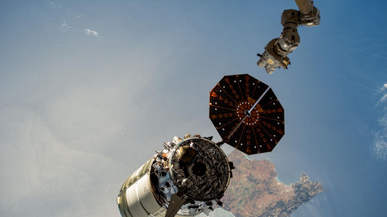
iss069e004822 (April 21, 2023) --- The Cygnus space freighter from Northrop Grumman is pictured moments after its release from the Canadarm2 robotic arm as the International Space Station orbited 262 miles above the Mediterranean Sea near the Spanish island of Mallorca.
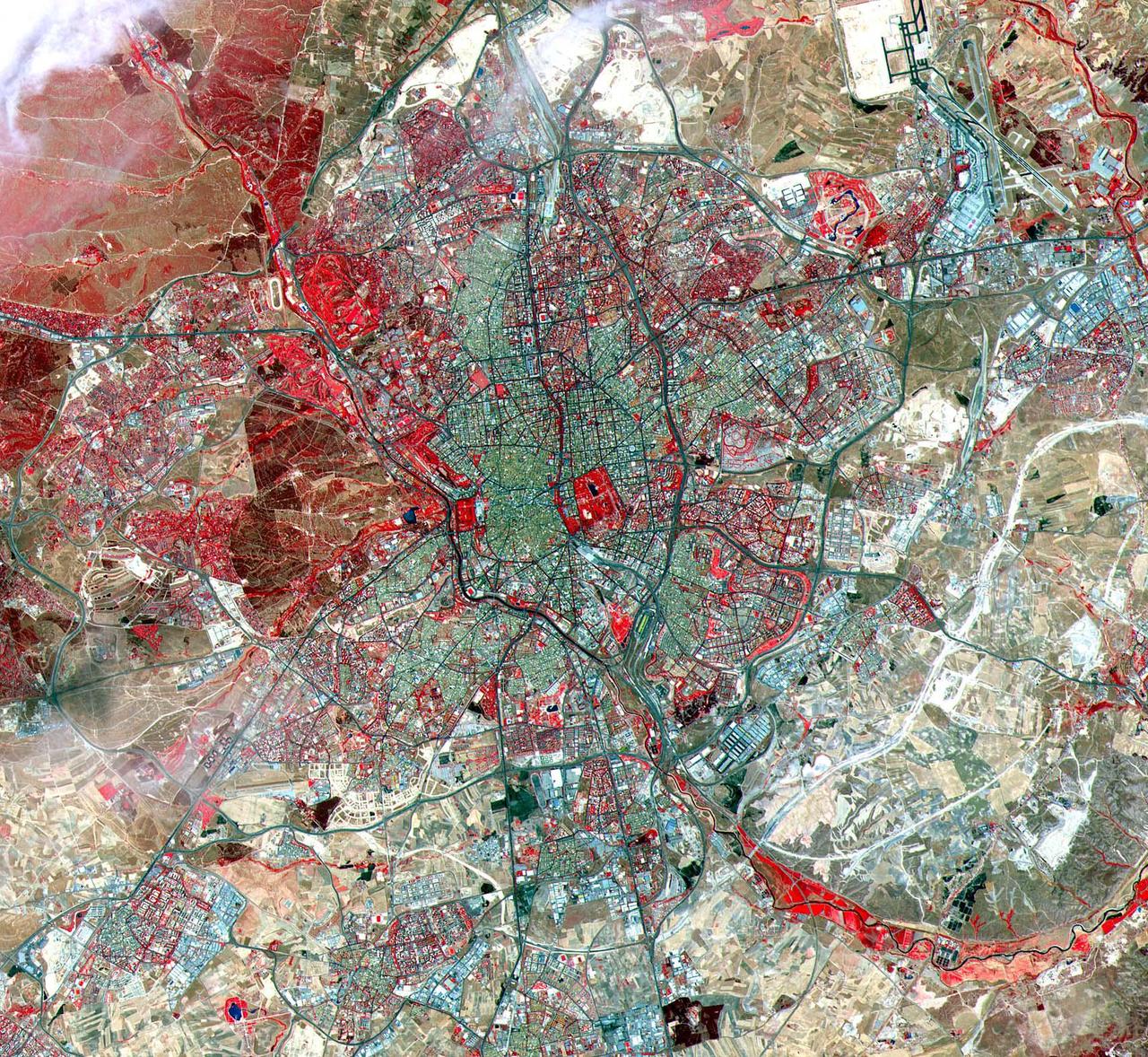
This ASTER image was acquired on July 5, 2000 and covers an area of 25 by 24 km over Madrid, Spain. A historic capital city, Madrid is renowned for its unique charm and its exhilarating cultural life. In the 10th century, a Moorish fortress called Magerit was first built on the site, a plateau 656 meters (2,150 feet) above sea level. Spanish Christians seized the city a century later, although Madrid remained relatively unimportant until 1561. It was then that the Spanish king Philip II chose it as the national capital, largely because of its geographic location in the very heart of the country. Some historic structures from this and later periods still grace the narrow streets of the old section of Madrid, although the Spanish Civil War exacted a heavy toll on the city. The image is located at 40.4 degrees north latitude and 3.7 degrees west longitude. http://photojournal.jpl.nasa.gov/catalog/PIA11163
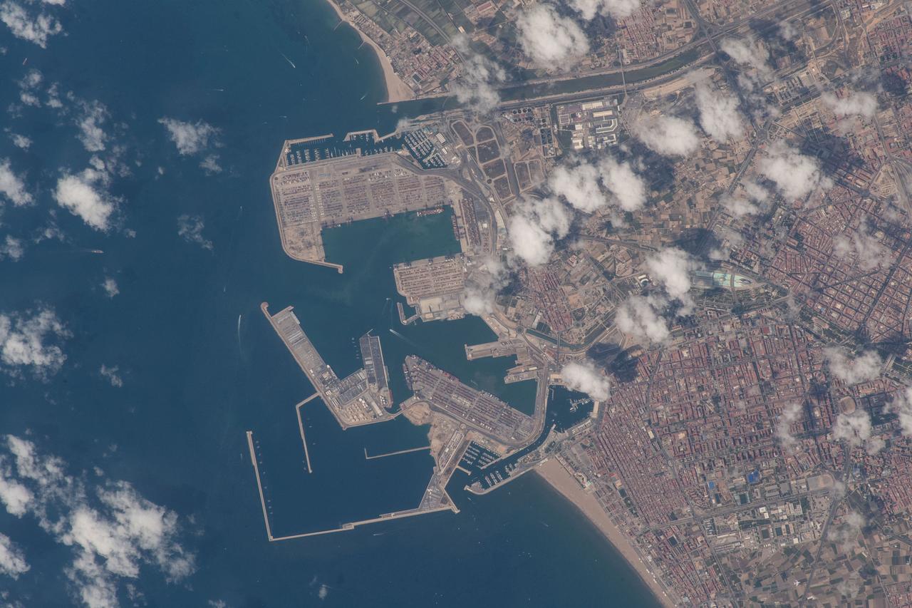
iss056e032465 (June 16, 2018) --- An Expedition 56 crew member photographed the Port de Valencia in the Spanish city of Valencia as the International Space Station orbited across the Mediterranean coast of Spain.
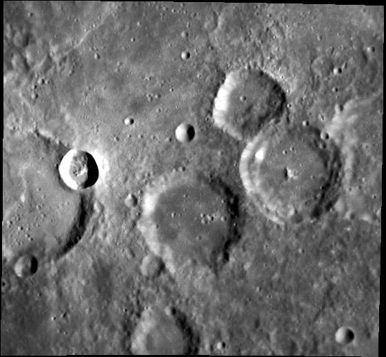
This MOC image shows two mesas on the northern plains of Mars. Mesa is the Spanish word for table, and that is a very good description of the two elliptical features captured in this MOC image
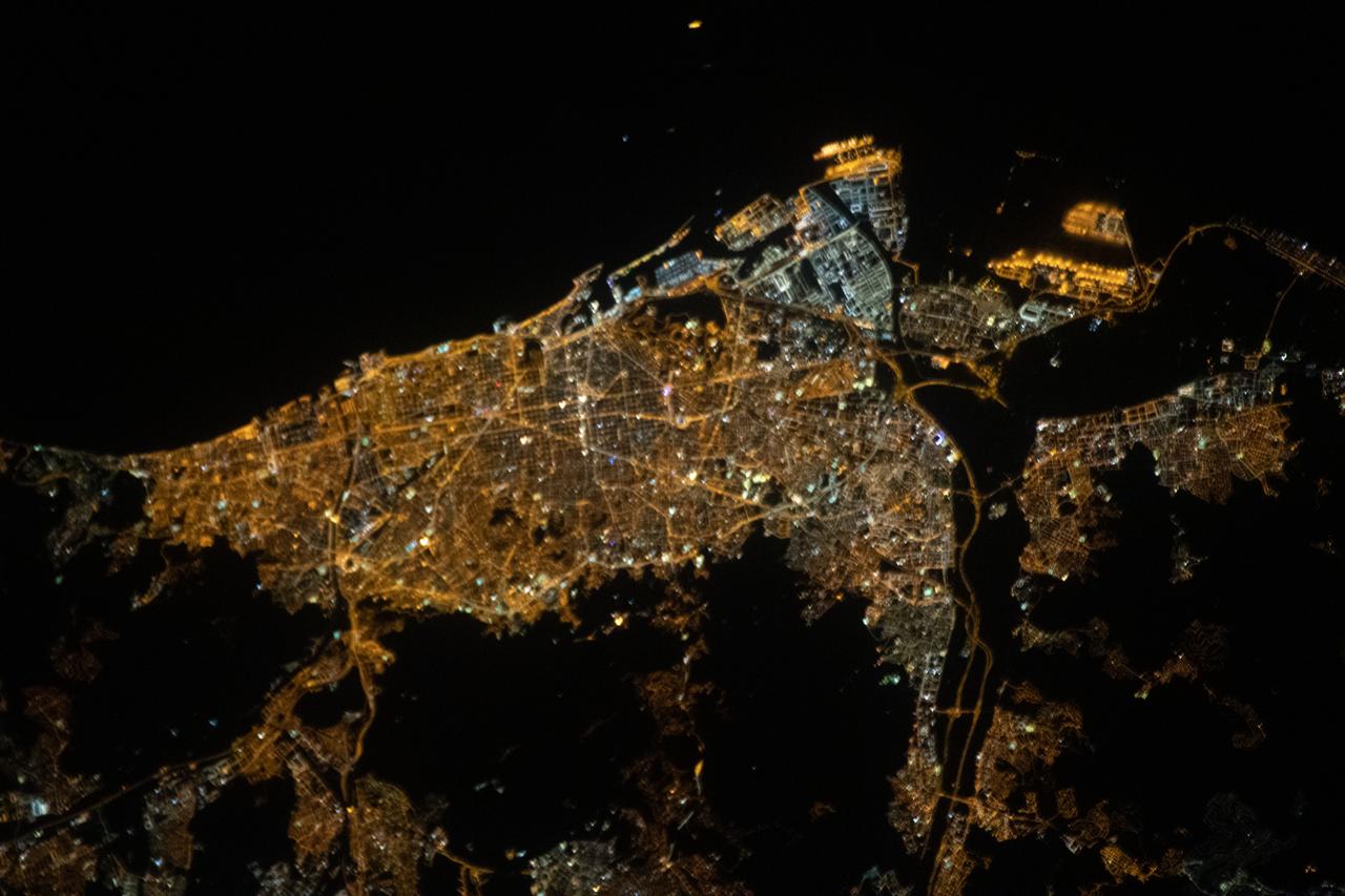
iss063e088813 (Sept. 15, 2020) --- This nighttime view of Barcelona, Spain, on the coast of the Balearic Sea, was taken from the International Space Station as it orbited above the east coast of the Spanish nation.

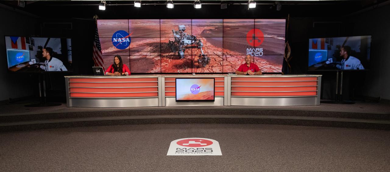
NASA’s Launch Services Program (LSP) Chief of Flight Projects Office Albert Sierra participates in a “Mars 2020 Social Media Q&A: En Español” program on Wednesday, July 22, at NASA’s Kennedy Space Center in Florida. The event featured representatives from LSP and NASA’s Jet Propulsion Laboratory. The Mars Perseverance rover is scheduled to lift off aboard a United Launch Alliance Atlas V 541 rocket from Cape Canaveral Air Force Station’s Space Launch Complex 41 on Thursday, July 30. The two-hour window opens at 7:50 a.m. EDT. LSP, based at Kennedy, is managing the launch.

Mars 2020 Social Media Q&A: En Español with representatives from NASA’s Launch Services Program and NASA’s Jet Propulsion Laboratory.

Elio Morillo, a Mars 2020 system testbed engineer from NASA’s Jet Propulsion Laboratory, speaks remotely while Albert Sierra, NASA’s Launch Services Program (LSP) chief of Flight Projects Office, listens during a “Mars 2020 Social Media Q&A: En Español” program on Wednesday, July 22, at NASA’s Kennedy Space Center in Florida. The event featured representatives from LSP and NASA’s Jet Propulsion Laboratory. The Mars Perseverance rover is scheduled to lift off aboard a United Launch Alliance Atlas V 541 rocket from Cape Canaveral Air Force Station’s Space Launch Complex 41 on Thursday, July 30. The two-hour window opens at 7:50 a.m. EDT. LSP, based at Kennedy, is managing the launch.

NASA Public Affairs Specialist Kristi Irastorza hosts a “Mars 2020 Social Media Q&A: En Español” program on Wednesday, July 22, at NASA’s Kennedy Space Center in Florida. The event featured representatives from NASA’s Launch Services Program (LSP) and NASA’s Jet Propulsion Laboratory. The Mars Perseverance rover is scheduled to lift off aboard a United Launch Alliance Atlas V 541 rocket from Cape Canaveral Air Force Station’s Space Launch Complex 41 on Thursday, July 30. The two-hour window opens at 7:50 a.m. EDT. LSP, based at Kennedy, is managing the launch.
NASA Public Affairs Specialist Kristi Irastorza, left, and NASA’s Launch Services Program (LSP) Chief of Flight Projects Office Albert Sierra, participate in a “Mars 2020 Social Media Q&A: En Español” program on Wednesday, July 22, at NASA’s Kennedy Space Center in Florida. The event featured representatives from LSP and NASA’s Jet Propulsion Laboratory. The Mars Perseverance rover is scheduled to lift off aboard a United Launch Alliance Atlas V 541 rocket from Cape Canaveral Air Force Station’s Space Launch Complex 41 on Thursday, July 30. The two-hour window opens at 7:50 a.m. EDT. LSP, based at Kennedy, is managing the launch.

NASA Public Affairs Specialist Kristi Irastorza hosts a “Mars 2020 Social Media Q&A: En Español” program on Wednesday, July 22, at NASA’s Kennedy Space Center in Florida. The event featured representatives from NASA’s Launch Services Program (LSP) and NASA’s Jet Propulsion Laboratory. The Mars Perseverance rover is scheduled to lift off aboard a United Launch Alliance Atlas V 541 rocket from Cape Canaveral Air Force Station’s Space Launch Complex 41 on Thursday, July 30. The two-hour window opens at 7:50 a.m. EDT. LSP, based at Kennedy, is managing the launch.

NASA Public Affairs Specialist Kristi Irastorza hosts a “Mars 2020 Social Media Q&A: En Español” program on Wednesday, July 22, at NASA’s Kennedy Space Center in Florida. The event featured representatives from NASA’s Launch Services Program (LSP) and NASA’s Jet Propulsion Laboratory. The Mars Perseverance rover is scheduled to lift off aboard a United Launch Alliance Atlas V 541 rocket from Cape Canaveral Air Force Station’s Space Launch Complex 41 on Thursday, July 30. The two-hour window opens at 7:50 a.m. EDT. LSP, based at Kennedy, is managing the launch.

NASA Public Affairs Specialist Kristi Irastorza, left, and NASA’s Launch Services Program (LSP) Chief of Flight Projects Office Albert Sierra, participate in a “Mars 2020 Social Media Q&A: En Español” program on Wednesday, July 22, at NASA’s Kennedy Space Center in Florida. The event featured representatives from LSP and NASA’s Jet Propulsion Laboratory. The Mars Perseverance rover is scheduled to lift off aboard a United Launch Alliance Atlas V 541 rocket from Cape Canaveral Air Force Station’s Space Launch Complex 41 on Thursday, July 30. The two-hour window opens at 7:50 a.m. EDT. LSP, based at Kennedy, is managing the launch.

NASA’s Launch Services Program (LSP) Chief of Flight Projects Office Albert Sierra participates in a “Mars 2020 Social Media Q&A: En Español” program on Wednesday, July 22, at NASA’s Kennedy Space Center in Florida. The event featured representatives from LSP and NASA’s Jet Propulsion Laboratory. The Mars Perseverance rover is scheduled to lift off aboard a United Launch Alliance Atlas V 541 rocket from Cape Canaveral Air Force Station’s Space Launch Complex 41 on Thursday, July 30. The two-hour window opens at 7:50 a.m. EDT. LSP, based at Kennedy, is managing the launch.
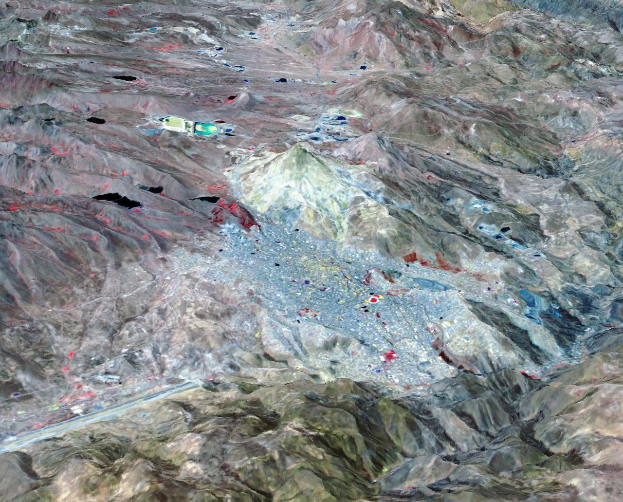
Potosi is the capital city of the Department of Potosi in Bolivia, and one of the highest cities in the world at 4090 m. For centuries it was the location of the Spanish colonial silver mint, the major supplier of silver for the Spanish Empire until the 18th century. Potosi lies at the foot of the Cerro Rico ("rich mountain"), rumored to be made of silver. Today, Potosi continues to be an important mining center, and is famous for its well-preserved colonial architecture. The perspective view covers an area of about 20 by 30 km, was acquired October 12, 2021, and is located at 19.6 degrees south, 65.7 degrees west. https://photojournal.jpl.nasa.gov/catalog/PIA25705
NASA is going to the Moon and on to Mars, in a measured, sustainable way. Working with U.S. companies and international partners, NASA will push the boundaries of human exploration forward to the Moon.
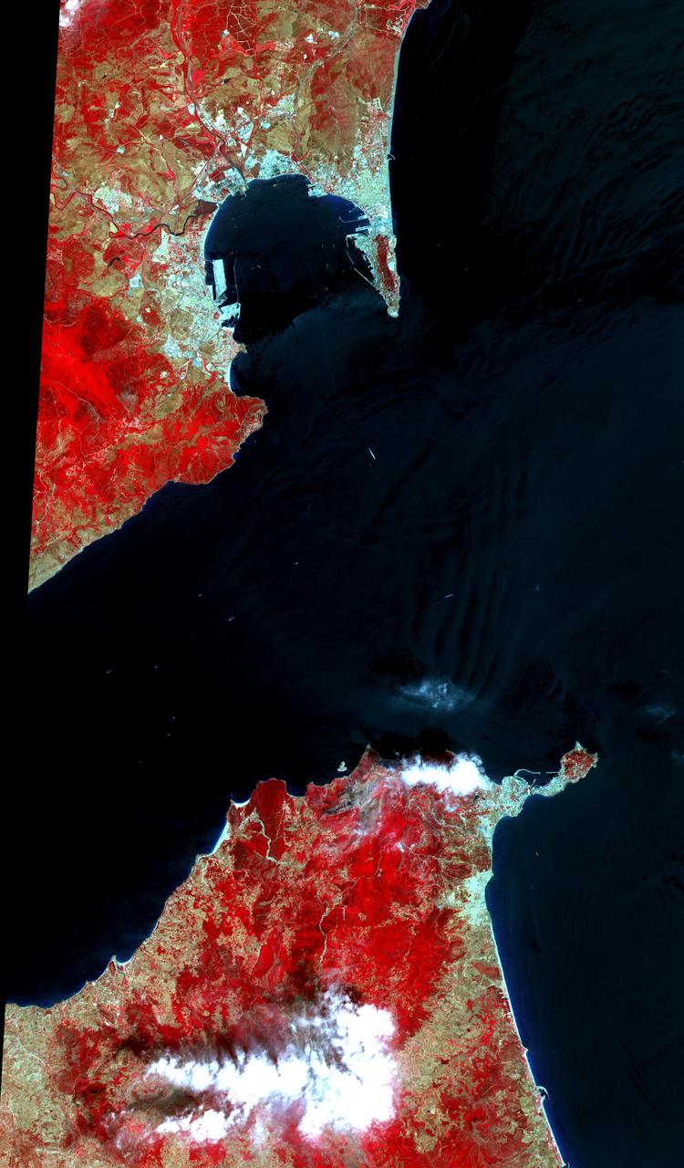
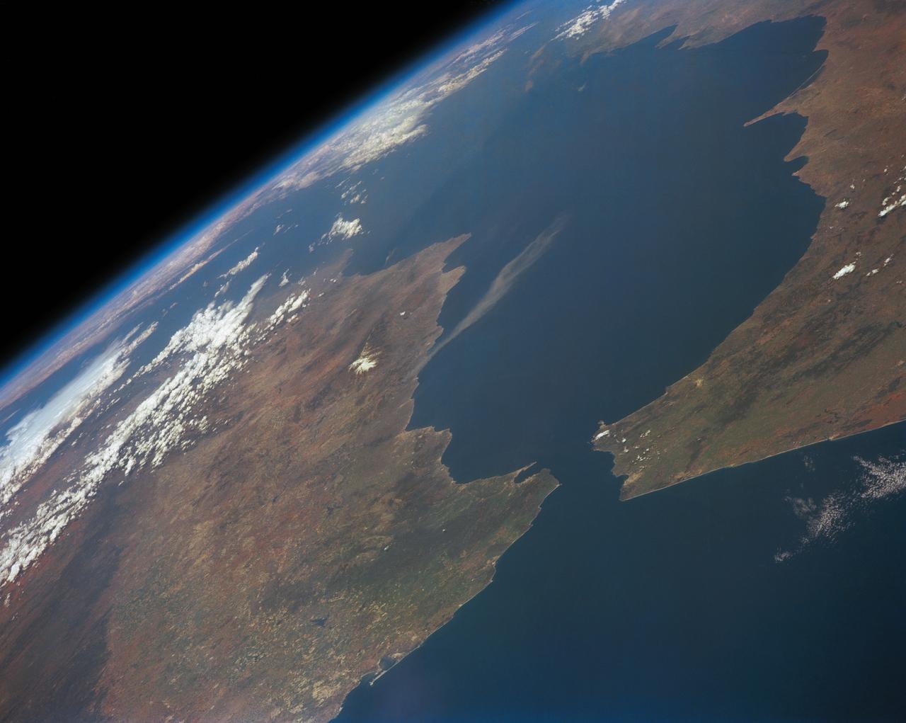
This 34 by 59 km sub-scene, acquired on July 5, 2000, covers the eastern part of the Strait of Gibraltar, separating Spain from Morocco. The promontory on the eastern side of the conspicuous Spanish port is the Rock of Gibraltar. The Rock of Gibraltar was once one of the two classical Pillars of Hercules, crowned with silver columns by Phoenician mariners to mark the limits of safe navigation for the ancient Mediterranean peoples. The rocky promontory still commands the western entrance to the Mediterranean Sea, separated from North Africa only by the narrow Strait of Gibraltar. A British colony, Gibraltar occupies a narrow strip of land at the southernmost tip of the Iberian Peninsula. It is separated from the Spanish mainland by a neutral zone contained on a narrow, sandy isthmus. The rocky limestone and shale ridge known as the Rock rises abruptly from the sea, to a maximum elevation of 426 meters (1,398 feet). Because of its strategic location and formidable topography, Gibraltar serves mainly as a British fortress. The Rock has traditionally been a symbol of British naval strength. Most of its sparse land is taken up by air and naval installations, and the civilian population is small. The image is centered at 36 degrees north latitude, 5.5 degrees west longitude. http://photojournal.jpl.nasa.gov/catalog/PIA11167
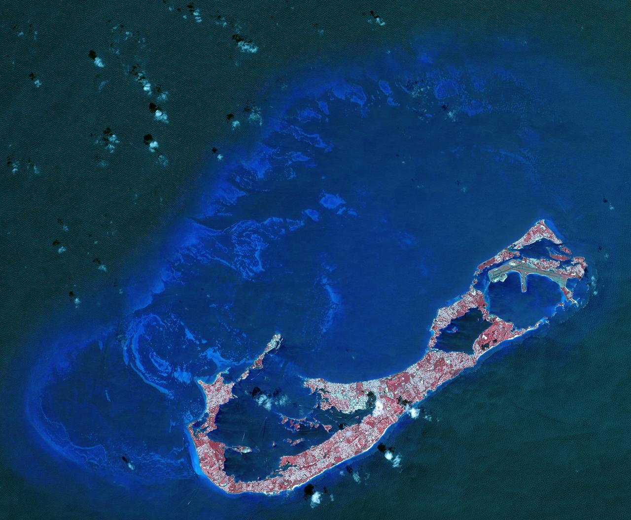
Bermuda is a British Overseas Territory in the western Atlantic off the east coast of North America. The uninhabited islands were first discovered in 1503 by the Spanish explorer Juan de Bermudez. In 1609 the English Virginia Colony settled Bermuda, and it has remained a British colony for over 400 years. Bermuda's economy is dominated by offshore insurance, and tourism, resulting in a very high GDP per capita. The image was acquired April 19, 2009, covers an area of 29.4 by 40.7 kilometers, and is located at 32.3 degrees north, 64.8 degrees west. http://photojournal.jpl.nasa.gov/catalog/PIA21315
ISS030-E-030290 (31 Dec. 2011) --- Majorca in the Balearic Islands (Spain) is featured in this image photographed by an Expedition 30 crew member aboard the International Space Station. The Balearic Islands are an archipelago located to the southwest of Spain in the Mediterranean Sea. Catalan – the native tongue – and Spanish are the official languages. The islands are an autonomous community and province of Spain, located approximately midway between the southeastern coastline of Spain and the northern coastline of Algeria. This photograph highlights the large island of Majorca (approximately 5,400 square kilometers; also known as Mallorca in Spanish) on which the capital city of Palma is located (center). The small island of Cabrera to the southwest of Majorca (upper left) hosts the Parc Nacional de l’Arxipelag de Cabrera (site mainly in Spanish). Like the other Balearic Islands, Majorca is a popular holiday destination for the European community with tourism forming a major part of the island’s economy. The island’s physiography offers many recreational opportunities – mountainous regions are present along the northwest coastline and eastern third, while much of the central part of the island is flat. Diving is also a popular activity. The central region includes agricultural lands (tan, light brown, and green, center), forested patches and corridors (dark green, center), and urban centers (gray). In addition to Majorca, the other major islands of the archipelago include Ibiza, Formentera, and Minorca.
S66-46062 (18-21 July 1966) --- Area of the Spanish Sahara--Mauritania--Algeria--Morocco, looking north into Hamada Du Dra, as seen from the Gemini-10 spacecraft. Taken with a J.A. Maurer 70mm camera, using Eastman Kodak, Ektachrome, MS (S.O. 217) color film. Photo credit: NASA
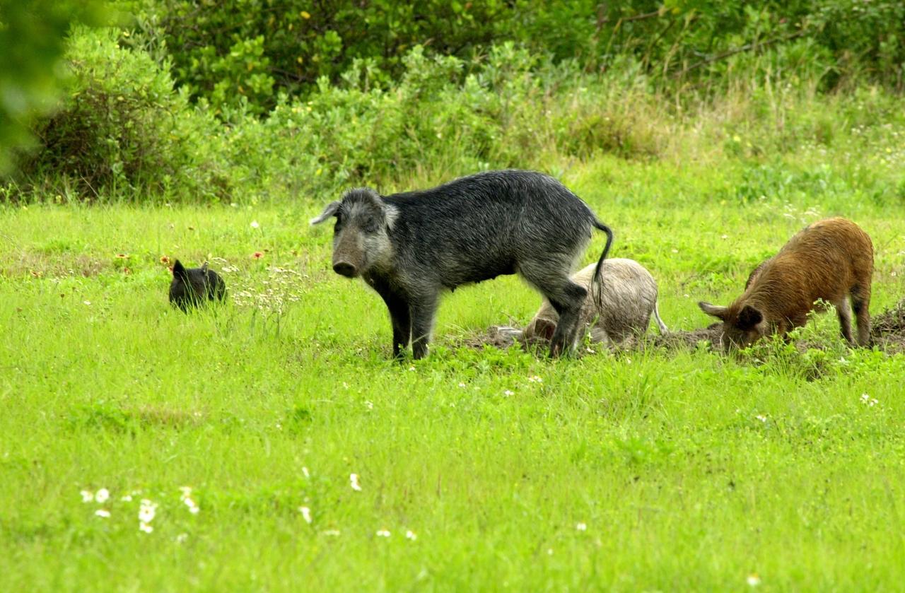
KENNEDY SPACE CENTER, FLA. -- Feral pigs dig for food on grounds near Kennedy Space Center. Not a native in the environment, the hogs are believed to be descendants from the pigs brought to Florida by the early Spanish explorers. Without many predators other than human, the pigs have flourished
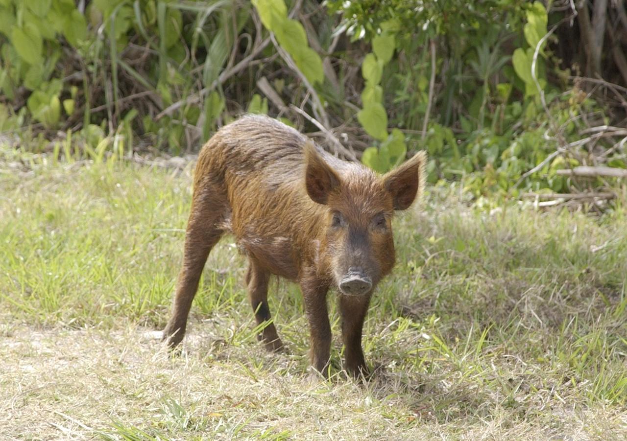
KENNEDY SPACE CENTER, FLA. - A wild pig is spotted near the KSC Press Site on its daily foraging rounds. Not a native in the environment, the pigs around KSC are believed to be descendants from those brought to Florida by the early Spanish explorers. Without many predators other than human, the pigs have flourished in the surrounding environs

S65-63256 (16 Dec. 1965) --- Cap Blanc and Levrier Bay on the coast of Spanish Sahara and Mauritania, as seen from the Gemini-6 spacecraft during its 15th revolution of Earth. Photo credit: NASA or National Aeronautics and Space Administration
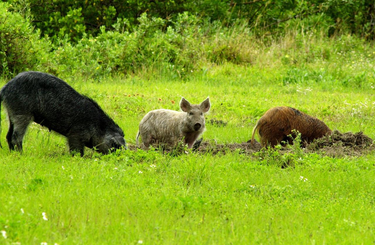
KENNEDY SPACE CENTER, FLA. -- Feral pigs dig for food on grounds near Kennedy Space Center. Not a native in the environment, the hogs are believed to be descendants from the pigs brought to Florida by the early Spanish explorers. Without many predators other than human, the pigs have flourished
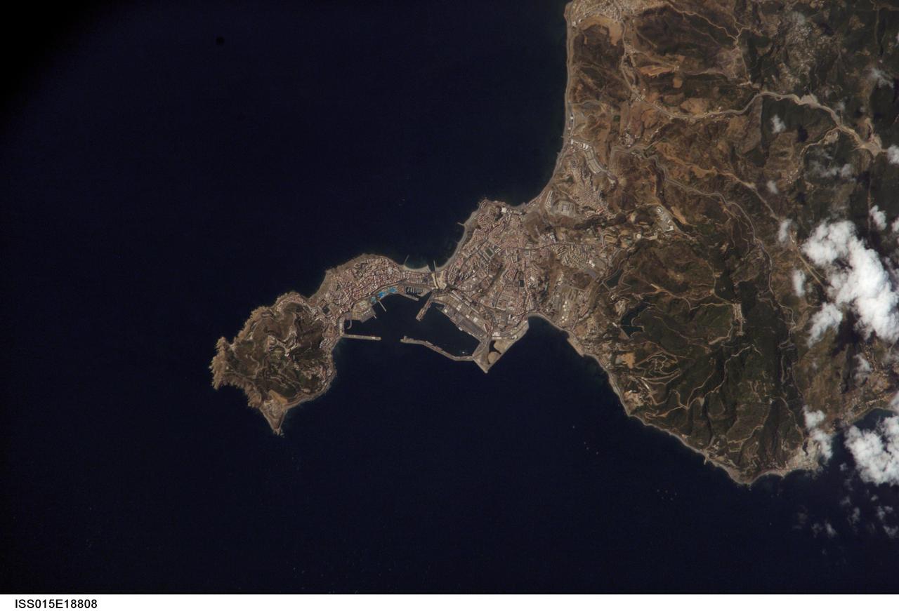
ISS015-E-18808 (21 July 2007) --- Ceuta on the northern African coastline is featured in this image photographed by an Expedition 15 crewmember on the International Space Station. The small Spanish enclave of Ceuta occupies a narrow isthmus of land on the African side of the Strait of Gibraltar. This view illustrates the sharp contrast in land cover between urban Ceuta (pink to white residential and industrial rooftops at center), the bay formed by seawalls to the north of the city, and the higher elevations of Monte Hacho forming the end of the isthmus. Green, vegetated slopes surround the Spanish fort atop the mountain, which commands a clear view of the Strait of Gibraltar to the northwest (not shown). Several small dots are visible near the coastline to the northwest and south of Ceuta -- these are small pleasure or fishing boats.

NASA Administrator Charles Bolden, right, poses with U.S. Rep. Lincoln Diaz-Balart, R-Fla., prior to the start of an event at the National Press Club in Washington, Tuesday, Feb. 23, 2010. NASA is working with Univision Communications Inc. to develop a partnership in support of the Spanish-language media outlet's initiative to improve high school graduation rates, prepare Hispanic students for college, and encourage them to pursue careers in science, technology, engineering and mathematics, or STEM, disciplines. Photo Credit: (NASA/Bill Ingalls)

Univision Communications President and Chief Executive Officer Joe Uva speaks at an event at the National Press Club in Washington, Tuesday, Feb. 23, 2010. NASA is working with Univision Communications Inc. to develop a partnership in support of the Spanish-language media outlet's initiative to improve high school graduation rates, prepare Hispanic students for college, and encourage them to pursue careers in science, technology, engineering and mathematics, or STEM, disciplines. Photo Credit: (NASA/Bill Ingalls)

Univision Networks president Cesar Conde speaks at the National Press Club in Washington, Tuesday, Feb. 23, 2010. NASA is working with Univision Communications Inc. to develop a partnership in support of the Spanish-language media outlet's initiative to improve high school graduation rates, prepare Hispanic students for college, and encourage them to pursue careers in science, technology, engineering and mathematics, or STEM, disciplines. Photo Credit: (NASA/Bill Ingalls)
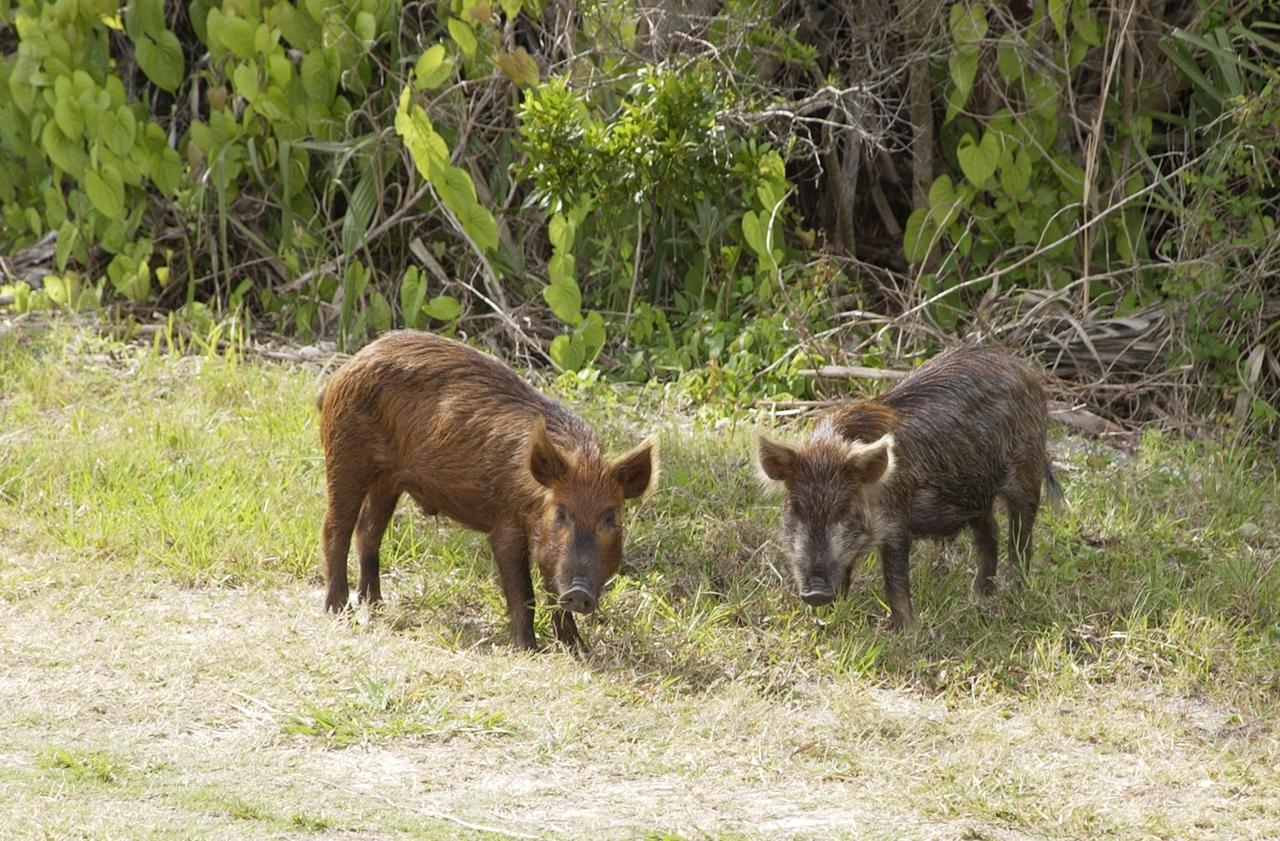
KENNEDY SPACE CENTER, FLA. - Wild pigs stop near the KSC Press Site in the Launch Complex 39 Area on their daily foraging rounds. Not a native in the environment, the pigs are believed to be descendants from those brought to Florida by the early Spanish explorers. Without many predators other than human, the pigs have flourished in the surrounding environs
S63-06434 (15-16 May 1963) --- East looking view across Atlantic waters toward Africa, showing Mauritania and Spanish Sahara photographed from the Mercury-Atlas 9 (MA-9) capsule by astronaut L. Gordon Cooper Jr., during his 22-orbit MA-9 spaceflight. Photo credit: NASA

NASA Administrator Charles Bolden, left, speaks with Melinda French Gates, of the Bill & Melinda Gates Foundation, right, prior to the start of an event at the National Press Club in Washington, Tuesday, Feb. 23, 2010. NASA is working with Univision Communications Inc. to develop a partnership in support of the Spanish-language media outlet's initiative to improve high school graduation rates, prepare Hispanic students for college, and encourage them to pursue careers in science, technology, engineering and mathematics, or STEM, disciplines. Photo Credit: (NASA/Bill Ingalls)

Univision news anchor Jorge Ramos speaks at an event at the National Press Club in Washington, Tuesday, Feb. 23, 2010. NASA is working with Univision Communications Inc. to develop a partnership in support of the Spanish-language media outlet's initiative to improve high school graduation rates, prepare Hispanic students for college, and encourage them to pursue careers in science, technology, engineering and mathematics, or STEM, disciplines. Photo Credit: (NASA/Bill Ingalls)

NASA Spanish Communications Lead María-José Viñas Garcia gives remarks during an event where NASA and the Hispanic Heritage Foundation signed a Space Act Agreement to collaborate and expand STEM opportunities for Latino K-12 and university students and reduce barriers to agency activities and opportunities, Monday, Sept. 30, 2024, at the NASA Headquarters Mary W. Jackson Building in Washington. Photo Credit: (NASA/Bill Ingalls)

NASA Spanish Communications Lead María-José Viñas Garcia gives remarks during an event where NASA and the Hispanic Heritage Foundation signed a Space Act Agreement to collaborate and expand STEM opportunities for Latino K-12 and university students and reduce barriers to agency activities and opportunities, Monday, Sept. 30, 2024, at the NASA Headquarters Mary W. Jackson Building in Washington. Photo Credit: (NASA/Bill Ingalls)

NASA Spanish Communications Lead María-José Viñas Garcia delivers opening remarks prior to an event with NASA astronauts Jessica Watkins, Kjell Lindgren, and Robert Hines at the Martin Luther King Jr Memorial Library, Thursday, March 30, 2023, in Washington. Lindgren, Hines, and Watkins spent 170 days in space as part of Expeditions 67 and 68 aboard the International Space Station. Photo Credit: (NASA/Keegan Barber)

Melinda French Gates, of the Bill & Melinda Gates Foundation, speaks during an event at the National Press Club in Washington, Tuesday, Feb. 23, 2010. NASA is working with Univision Communications Inc. to develop a partnership in support of the Spanish-language media outlet's initiative to improve high school graduation rates, prepare Hispanic students for college, and encourage them to pursue careers in science, technology, engineering and mathematics, or STEM, disciplines. Photo Credit: (NASA/Bill Ingalls)

U.S. Secretary of Labor Hilda Solis speaks at an event at the National Press Club in Washington, Tuesday, Feb. 23, 2010. NASA is working with Univision Communications Inc. to develop a partnership in support of the Spanish-language media outlet's initiative to improve high school graduation rates, prepare Hispanic students for college, and encourage them to pursue careers in science, technology, engineering and mathematics, or STEM, disciplines. Photo Credit: (NASA/Bill Ingalls)

U.S. Secretary of Education Arne Duncan speaks during an event at the National Press Club in Washington, Tuesday, Feb. 23, 2010. NASA is working with Univision Communications Inc. to develop a partnership in support of the Spanish-language media outlet's initiative to improve high school graduation rates, prepare Hispanic students for college, and encourage them to pursue careers in science, technology, engineering and mathematics, or STEM, disciplines. Photo Credit: (NASA/Bill Ingalls)

U.S. Secretary of Education Arne Duncan speaks at an event at the National Press Club in Washington, Tuesday, Feb. 23, 2010. NASA is working with Univision Communications Inc. to develop a partnership in support of the Spanish-language media outlet's initiative to improve high school graduation rates, prepare Hispanic students for college, and encourage them to pursue careers in science, technology, engineering and mathematics, or STEM, disciplines. Photo Credit: (NASA/Bill Ingalls)

NASA Spanish Communications Lead María-José Viñas Garcia gives remarks during an event where NASA and the Hispanic Heritage Foundation signed a Space Act Agreement to collaborate and expand STEM opportunities for Latino K-12 and university students and reduce barriers to agency activities and opportunities, Monday, Sept. 30, 2024, at the NASA Headquarters Mary W. Jackson Building in Washington. Photo Credit: (NASA/Bill Ingalls)

Melinda French Gates, of the Bill & Melinda Gates Foundation speaks at an event at the National Press Club in Washington, Tuesday, Feb. 23, 2010. NASA is working with Univision Communications Inc. to develop a partnership in support of the Spanish-language media outlet's initiative to improve high school graduation rates, prepare Hispanic students for college, and encourage them to pursue careers in science, technology, engineering and mathematics, or STEM, disciplines. Photo Credit: (NASA/Bill Ingalls)

Swift currents flow through the Strait of Gibraltar, producing complicated patterns in the surface waters. Some of those patterns are highlighted in the sunglint in this photograph. The Mediterranian Sea is on the upper right, the Atlantic Ocean in in the lower left. Few features can be seen on the Mediterranian side, but current shears (straight lines coming off Spain), several sets of internal waves (impinging on the Spanish continental shelf) and ship wakes can be seen on the Atlantic side, west of Cadiz. Both Tangier and Cadiz show up in the sunglint as well.

The Strait of Gibraltar separates Spain from Morocco. This image, acquired on July 5, 2000, covers an area 34 kilometers (21 miles) wide and 59 kilometers (37 miles) long in three bands of the reflected visible and infrared wavelength region. The promontory on the eastern side of the conspicuous Spanish port is the Rock of Gibraltar. Once one of the two classical Pillars of Hercules, the Rock was crowned with silver columns by Phoenician mariners to mark the limits of safe navigation for the ancient Mediterranean peoples. The rocky promontory still commands the western entrance to the Mediterranean Sea. The rocky limestone and shale ridge rises abruptly from the sea, to a maximum elevation of 426 meters (1,398 feet). A British colony, Gibraltar occupies a narrow strip of land at the southernmost tip of the Iberian Peninsula. It is separated from the Spanish mainland by a neutral zone contained on a narrow, sandy isthmus. Because of its strategic location and formidable topography, Gibraltar serves mainly as a British fortress. Most of its sparse land is taken up by air and naval installations, and the civilian population is small. http://photojournal.jpl.nasa.gov/catalog/PIA02657
NASA's Opportunity rover used its Microscopic Imager to take a picture of this rock nicknamed "Jornada del Muerto" while in Perseverance Valley. The wind-carved streaks along its face were very similar to rocks seen at the rim of Endeavour Crater earlier in Opportunity's mission. This scene is about 2 inches (5 centimeters) wide. "Jornada del Muerto" (roughly translated: "Dead Man's Journey") was one of the stops along the El Camino Real route used for centuries by Spanish and Mexican colonists to reach New Mexico from Mexico, and used by the Opportunity team to name rocks and features in Perseverance Valley. https://photojournal.jpl.nasa.gov/catalog/PIA23245
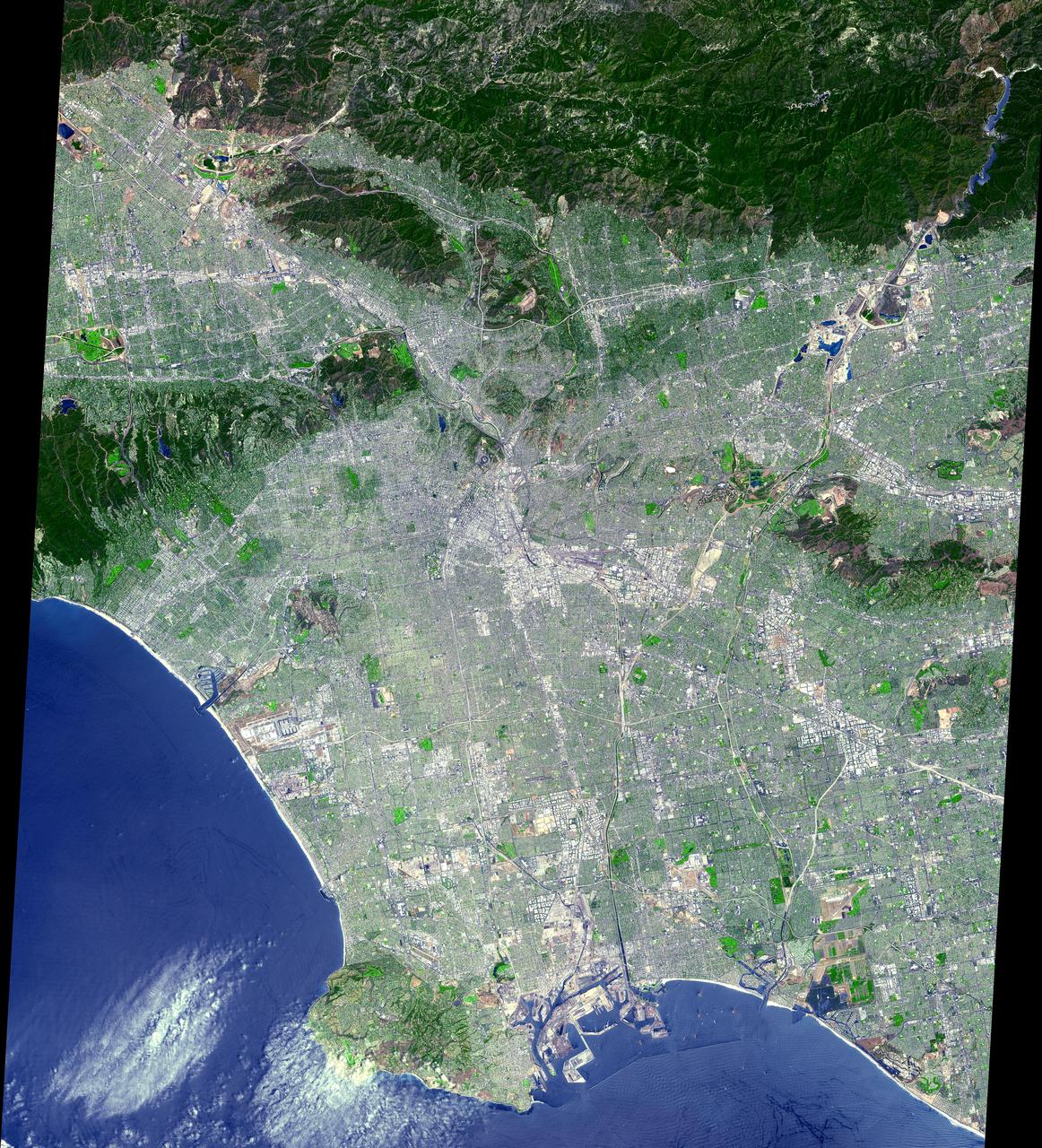
This ASTER image was acquired on July 23, 2001 and covers an area of 64 x 72 km. The data were processed to create a simulated natural color image. From its start as a sleepy Spanish pueblo in 1781, LA and its metropolitan area has grown to become an ethnically diverse, semitropical megalopolis, laying claim as the principal center of the western US and the nation's second largest urban area. The city's economy is based on international trade, aerospace, agriculture, tourism, and filmmaking. LA provides a glimpse of the typically cosmopolitan and global city of the future. The image is located at 34.1 degrees north latitude and 118.2 degrees west longitude. http://photojournal.jpl.nasa.gov/catalog/PIA02679
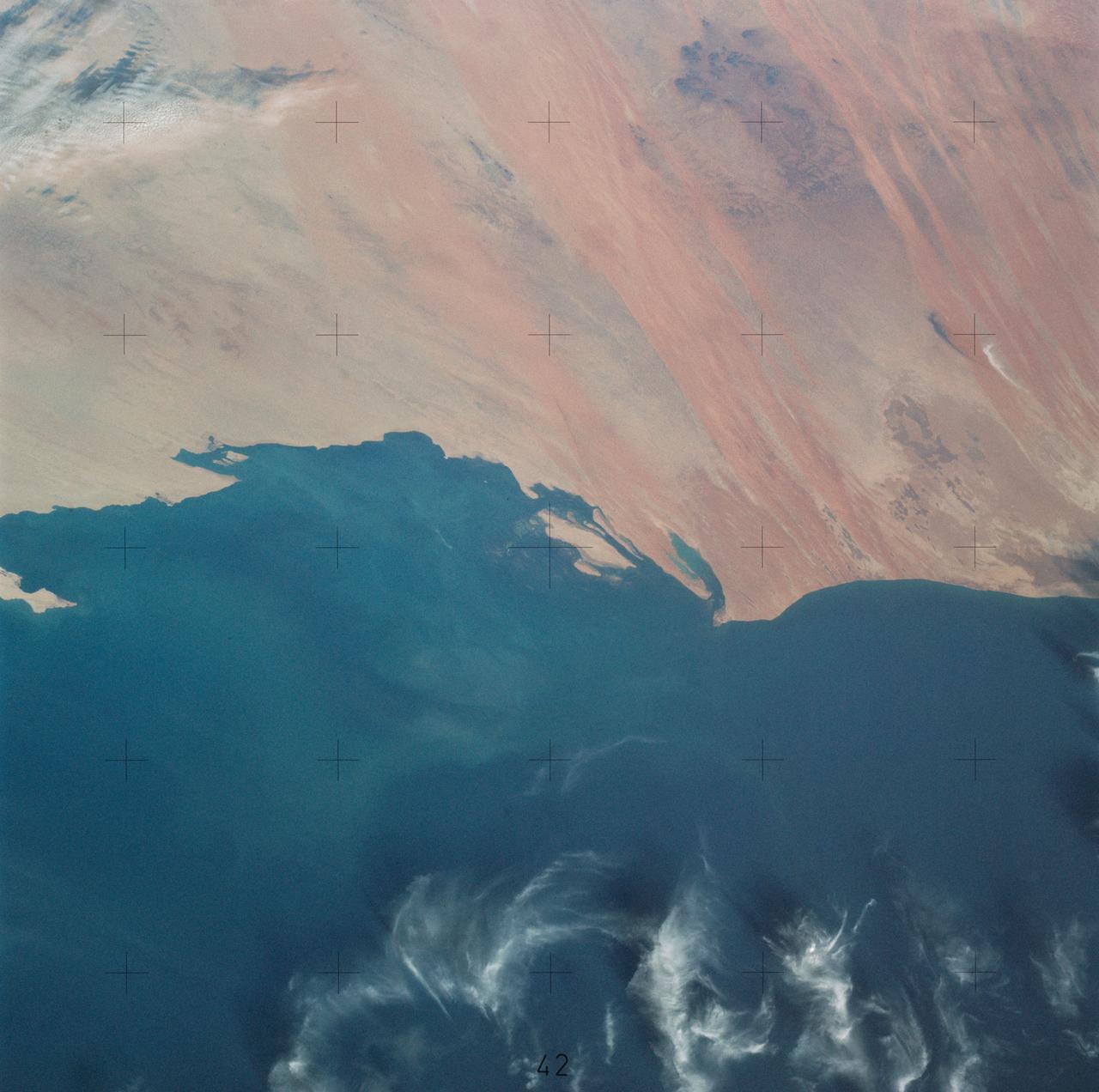
SL4-138-3756 (28 Dec. 1973) --- The northern half of Mauritania's Atlantic Coast, as photographed from the Skylab space station in Earth orbit by one of the Skylab 4 crewmen. The camera used was a hand-held 70mm Hasselblad, with SO-368 medium-speed Ektachrome. Spanish Sahara is just out of the picture to the north. The linear chains of sand dunes leading to the sea were the objects of study in an effort to better understand deserts and their formations. Photographs such as this were compared with similar ones taken over the drought-stricken areas including Mali and Niger in an attempt to understand the desertification processes which may be occurring there. Photo credit: NASA

María-José Viñas, NASA’s Spanish language communications lead, left, introduces NASA astronauts Frank Rubio, second from left, and Stephen Bowen and UAE (United Arab Emirates) astronaut Sultan Alneyadi as the trio visited Rolling Terrance Elementary School to speak to students, Friday, March 22, 2024, in Takoma Park, Maryland. Bowen and Alneyadi spent 186 days aboard the International Space Station as part of Expedition 69; while Rubio set a new record for the longest single spaceflight by a U.S. astronaut, spending 371 days in orbit on an extended mission spanning Expeditions 68 and 69. Photo Credit: (NASA/Joel Kowsky)

CAPE CANAVERAL, Fla. -- At the Shuttle Landing Facility at NASA's Kennedy Space Center in Florida, Professor Sam Ting, AMS Principal Investigator from the Massachusetts Institute of Technology listens intently as Professor Manuel Aguilar, AMS Spanish Coordinator, speaks to the media before the arrival of the Alpha Magnetic Spectrometer, or AMS. AMS, a state-of-the-art particle physics detector, is designed to operate as an external module on the International Space Station. It will use the unique environment of space to study the universe and its origin by searching for dark matter. The STS-134 crew will fly AMS to the International Space Station aboard space shuttle Endeavour, targeted to launch Feb. 26, 2011. Photo credit: NASA/Kim Shiflett
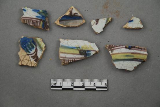
Artifacts retrieved from the ruins of Elliot Plantation on NASA’s Kennedy Space Center in Florida include Spanish majolica fragments, likely produced between the 1730s to the 1750s and imported to the plantation from England. Ceramic fragments of majolica, delftware, and other high-status domestic wares were retrieved from ruins determined to be the dwelling of the plantation overseer. The ruins of Elliot Plantation date from the 1760s and represent the largest, earliest, and southernmost British period sugar plantation in the U.S., as well as one of the most intact and best examples of a completely preserved enslaved landscape. In interagency cooperation between the National Park Service, the U.S. Fish and Wildlife Service, and NASA, and with the assistance of volunteers from the Indian River Anthropological Society, and historic preservation offices of Brevard and Volusia counties, approximately 200 shovel tests and 20 excavation units were completed in three areas of the plantation complex from 2008 to 2009.
KENNEDY SPACE CENTER, Fla. - A small herd of wild pigs root for food along the bank of this body of water at Kennedy Space Center. Not a native in the environment, the pigs are believed to be descendants from those brought to Florida by the early Spanish explorers. Without many predators other than human, the pigs have flourished in the surrounding environs, primarily the Merritt Island National Wildlife Refuge, which shares a boundary with the Center. The Wildlife Refuge encompasses 92,000 acres that are a habitat for more than 331 species of birds, 31 mammals, 117 fishes, and 65 amphibians and reptiles. The marshes and open water of the refuge provide wintering areas for 23 species of migratory waterfowl, as well as a year-round home for great blue herons, great egrets, wood storks, cormorants, brown pelicans and other species of marsh and shore birds, plus a variety of insects.

CAPE CANAVERAL, Fla. – During a Spanish language news conference at NASA's Kennedy Space Center in Florida, agency officials discussed preparations for the launch of the Mars Atmosphere and Volatile EvolutioN, or MAVEN, mission. Participating in the briefing, from the left, are Andres Adorno of NASA Public Affairs, Jared Espley, project scientist at Goddard Space Flight Center in Greenbelt, Md., Sandra Cauffman, deputy project manager at Goddard and Diana Calero, launch integration engineer in NASA's Launch Services Program at Kennedy. MAVEN is being prepared for its scheduled launch on Nov 18, 2013 from Cape Canaveral Air Force Station, Fla. atop a United Launch Alliance Atlas V rocket. Positioned in an orbit above the Red Planet, MAVEN will study the upper atmosphere of Mars in unprecedented detail. For information on the MAVEN mission, visit: http://www.nasa.gov/mission_pages/maven/main/index.html. Photo credit: NASA/Kim Shiflett

CAPE CANAVERAL, Fla. – During a Spanish language news conference at NASA's Kennedy Space Center in Florida, agency officials discussed preparations for the launch of the Mars Atmosphere and Volatile EvolutioN, or MAVEN, mission. Participating in the briefing is Sandra Cauffman, deputy project manager at the Goddard Space Flight Center in Greenbelt, Md. MAVEN is being prepared for its scheduled launch on Nov 18, 2013 from Cape Canaveral Air Force Station, Fla. atop a United Launch Alliance Atlas V rocket. Positioned in an orbit above the Red Planet, MAVEN will study the upper atmosphere of Mars in unprecedented detail. For information on the MAVEN mission, visit: http://www.nasa.gov/mission_pages/maven/main/index.html. Photo credit: NASA/Kim Shiflett
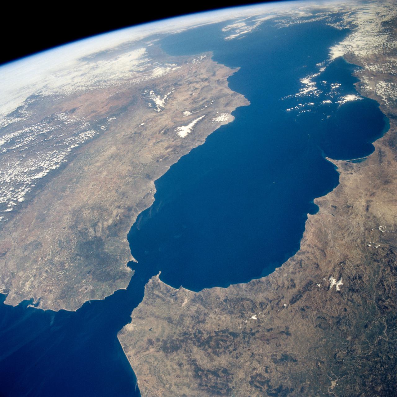
STS059-238-074 (9-20 April 1994) --- The Atlantic Ocean, Straits of Gibraltar, and Alboran Sea (the westernmost portion of the Mediterranean Sea) separate Spain on the left from Morocco on the right. Algeciras Harbor is the prominent notch cut out of the eastern end of the north shore of the Strait; the Rock of Gibraltar is the tiny arrowhead that separates the notch from the Alboran Sea. The Sierra Nevada, farther away down the Spanish coast, lives up to its name in this April scene. The difference in elevation between the Sierra Morena and the Guadalquivir River valley is highlighted nicely by cumulus clouds. Tangier, Morocco can be seen as a light-toned spot on the southern shore of the Strait, near the entrance to the Atlantic Ocean. Hasselblad photograph.

CAPE CANAVERAL, Fla. – During a Spanish language news conference at NASA's Kennedy Space Center in Florida, agency officials discussed preparations for the launch of the Mars Atmosphere and Volatile EvolutioN, or MAVEN, mission. Participating in the briefing is Diana Calero, launch integration engineer in NASA's Launch Services Program at Kennedy. MAVEN is being prepared for its scheduled launch on Nov 18, 2013 from Cape Canaveral Air Force Station, Fla. atop a United Launch Alliance Atlas V rocket. Positioned in an orbit above the Red Planet, MAVEN will study the upper atmosphere of Mars in unprecedented detail. For information on the MAVEN mission, visit: http://www.nasa.gov/mission_pages/maven/main/index.html. Photo credit: NASA/Kim Shiflett
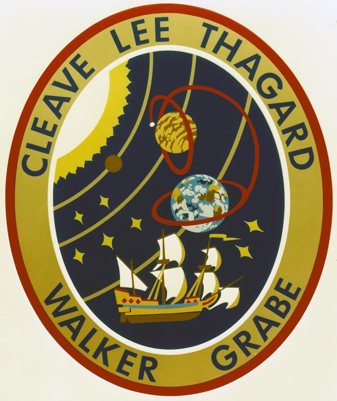
The STS-30 patch depicts the joining of NASA's manned and unmanned space programs. The sun and inner planets of our solar system are shown with the curve connecting Earth and Venus symbolizing the shuttle orbit, the spacecraft trajectory toward Venus, and its subsequent orbit around our sister planet. A Spanish caravel similar to the ship on the official Magellan program logo commemorates the 16th century explorer's journey and his legacy of adventure and discovery. Seven stars on the patch honor the crew of Challenger. The five-star cluster in the shape of the constellation Cassiopeia represent the five STS-30 crewmembers - Astronauts David Walker, Ronald Grabe, Norman Thagard, Mary Cleave and Mark Lee - who collectively designed the patch.
AS08-16-2588 (21-27 Dec. 1968) --- Both sides of the Atlantic Ocean are visible in this view from Apollo 8 spacecraft. (Hold picture with Earth at bottom left). The large, most prominent land mass is the bulge of West Africa. The portion of Africa near the equator is dark and cloudy, but the more northerly portions are clear, showing the prominent cape at Dakar and the Senegal River in Senegal; Cap Blanc; the Adrar Plateau in Mauretania; the wide expanse of desert in Algeria and Spanish Sahara; and the far edge, the Atlas and Anti-Atlas Mountains in Morocco. Clouds cover the eastern coast of South America, southward from Surinam and Guyana to near the city of Salvador, Brazil. The view was photographed following trans-lunar insertion.

CAPE CANAVERAL, Fla. – During a Spanish language news conference at NASA's Kennedy Space Center in Florida, agency officials discussed preparations for the launch of the Mars Atmosphere and Volatile EvolutioN, or MAVEN, mission. Participating in the briefing is Jared Espley, project scientist at Goddard Space Flight Center in Greenbelt, Md. MAVEN is being prepared for its scheduled launch on Nov 18, 2013 from Cape Canaveral Air Force Station, Fla. atop a United Launch Alliance Atlas V rocket. Positioned in an orbit above the Red Planet, MAVEN will study the upper atmosphere of Mars in unprecedented detail. For information on the MAVEN mission, visit: http://www.nasa.gov/mission_pages/maven/main/index.html. Photo credit: NASA/Kim Shiflett
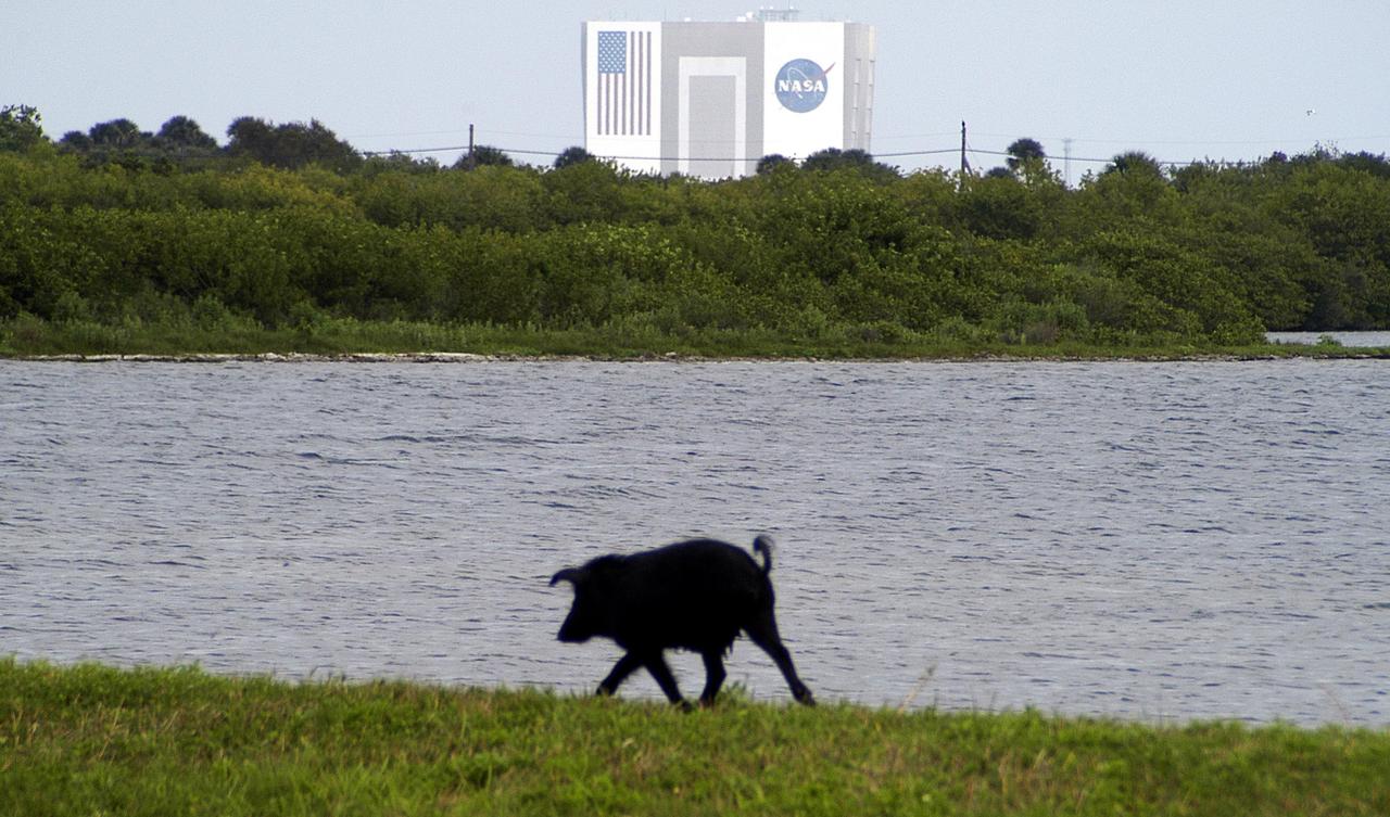
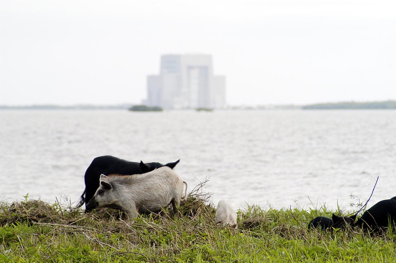
KENNEDY SPACE CENTER, Fla. - A lone wild pig travels the bank of a body of water near Kennedy Space Center. In the background is the 525-foot-high Vehicle Assembly Building. Not a native in the environment, the pigs are believed to be descendants from those brought to Florida by the early Spanish explorers. Without many predators other than human, the pigs have flourished in the surrounding environs, primarily the Merritt Island National Wildlife Refuge, which shares a boundary with the Center. The Wildlife Refuge encompasses 92,000 acres that are a habitat for more than 331 species of birds, 31 mammals, 117 fishes, and 65 amphibians and reptiles. The marshes and open water of the refuge provide wintering areas for 23 species of migratory waterfowl, as well as a year-round home for great blue herons, great egrets, wood storks, cormorants, brown pelicans and other species of marsh and shore birds, plus a variety of insects.
La Paz, Bolivia is the highest capital in the world, located on the Andes' Altiplano plateau at more than 3500 meters above sea level. It is situated in a bowl-like depression, surrounded by high mountains. La Paz was founded in 1548 by Spanish conquistadors at the site of the Inca settlement of Laja. Like many South American cities, La Paz and its suburbs have seen remarkable growth in the last 30 years. From 1986 to 2017 the population grew from about 400,000 to over 2.3 million. The ASTER image was acquired July 11, 2017. The images cover an area of 27 by 33 kilometers, and are located at 16.5 degrees south, 68.1 degrees west. https://photojournal.jpl.nasa.gov/catalog/PIA21220
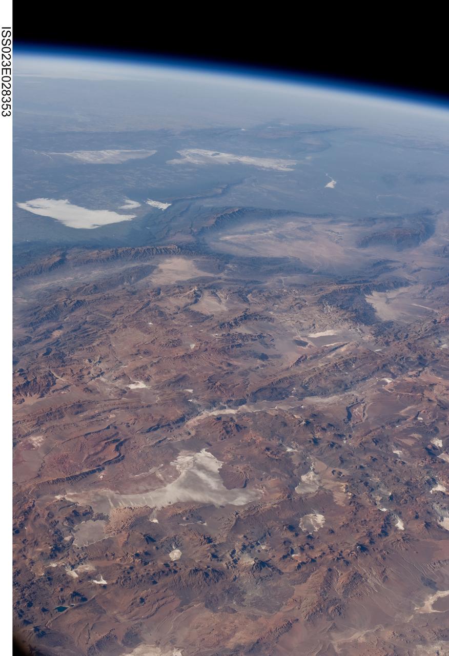
ISS023-E-028353 (26 April 2010) --- Central Andes Mountains, Salar de Arizaro, Argentina are featured in this image photographed by an Expedition 23 crew member on the International Space Station. The high plains (3,000 to greater than 5,000 meters elevation, 13,000 to 19,000 feet) of the Andes Mountains, also known as the Puna, appear in the foreground of this photograph, with a line of young volcanoes facing the much lower Atacama Desert (1,000–2,000 meters elevation). Several large dry lakes, marked by light-toned salt crusts, occupy the basins between major thrust faults in the Puna. Salar de Arizaro (foreground) is the largest of the dry lakes in this view (salar means waterless salt flat in Spanish). This panorama was taken by a station crew member looking southeast across the South American continent when the ISS was almost directly over the Atacama Desert near Chile’s Pacific coast. The Atlantic Ocean coastline (River Plate where Argentina’s capital city of Buenos Aires is located) is dimly visible at top left. A striking geological and landscape contrast is visible at center which separates two distinct geological zones, namely the Puna and the Sierras Pampeanas. The Sierras Pampeanas Mountains are lower in elevation and have few young volcanoes, in contrast to the Puna. Sharp-crested ranges are separated by wide, low valleys in this region. The Salinas Grandes—ephemeral shallow salt lakes at top left (salina means salt lake in Spanish) — occupies one of these valleys. The general color change from reds and browns in the foreground to blues and greens in the upper part of the image reflects the major climatic regions, namely the deserts of the Atacama and Puna, versus the low grassy plains of central Argentina where rainfall is sufficient to promote lush prairie grass growth—known famously as the pampas in Argentina. The Salinas Grandes mark an intermediate semiarid region. What accounts for the changes in landscape? The geology of this part of the Andes is a result of the eastward subduction of the Nazca tectonic plate underneath South America. Investigations using seismic data suggest that the Puna is underlain by a steeply dipping sector of the subducting Nazca plate. The Sierras Pampeanas zone however, is underlain by a sector of the Nazca plate that is almost horizontal, possibly due to the subduction of a submarine mountain range known as the Juan Fernandez Ridge. In the simplest terms, ridges are topographic highs that are difficult to stuff down subduction zones, with profound effects on the volcanism and structures of the upper plate.
NASA Dryden Mission Manager Walter Klein passes out Airborne Science stickers and lithographs to underprivileged school children that visited the airport on Monday March 8, 2004. In spanish, he explained to them the mission of the DC-8 AirSAR 2004 Mesoamerican campaign in Costa Rica. AirSAR 2004 Mesoamerica is a three-week expedition by an international team of scientists that uses an all-weather imaging tool, called the Airborne Synthetic Aperture Radar (AirSAR) which is located onboard NASA's DC-8 airborne laboratory. Scientists from many parts of the world including NASA's Jet Propulsion Laboratory are combining ground research done in several areas in Central America with NASA's AirSAR technology to improve and expand on the quality of research they are able to conduct. The radar, developed by NASA's Jet Propulsion Laboratory, can penetrate clouds and also collect data at night. Its high-resolution sensors operate at multiple wavelengths and modes, allowing AirSAR to see beneath treetops, through thin sand, and dry snow pack. AirSAR's 2004 campaign is a collaboration of many U.S. and Central American institutions and scientists, including NASA; the National Science Foundation; the Smithsonian Institution; National Geographic; Conservation International; the Organization of Tropical Studies; the Central American Commission for Environment and Development; and the Inter-American Development Bank.
ISS010-E-20111 (15 March 2005) --- Lima, Peru is featured in this image photographed by an Expedition 10 crewmember on the International Space Station (ISS). Located on the broad alluvial fan of the Rimac River, Lima is the capital of Peru and the only mega city (7.7 million inhabitants in 2002) located on the western coastline of South America. The city was established by Francisco Pizarro in 1535 and became an important colonial port linking silver mines of the Altiplano of the high Andes to the east with the burgeoning Spanish empire. During the mid-20th century a significant relocation of people from rural mountain communities into the Lima metropolitan area led to its growth into a mega city. Problems now facing the metropolitan region include development of adequate water resources, control of pollution, and the potential effects of natural hazards such as earthquakes and landslides. This photograph depicts the wealthier San Isidro and Mira Flores quarters of Lima. This part of the metropolitan area is characterized by numerous vegetated parks, golf courses (such as the Lima Golf Course—approximately 1 kilometer long), and greenbelts interspersed with residential and commercial areas. The higher proportion of dark asphalt in the street grid of the residential and commercial areas lends a purple coloration to the left portion of the image (downtown Lima is to the north). Regions with fewer built materials and vegetation are light tan. Wave patterns are visible approaching beaches, popular tourist destinations, in the lower half of the image.
STS-95 Mission Specialist Pedro Duque of Spain (center), with the European Space Agency, poses with two high-ranking Spanish military officers. Duque was one of a crew of seven aboard orbiter Discovery which landed at the Shuttle Landing Facility at 12:04 p.m. EST after a successful mission spanning nine days and 3.6 million miles. The other STS-95 crew members are Mission Commander Curtis L. Brown Jr.; Pilot Steven W. Lindsey; Mission Specialists Stephen K. Robinson and Scott E. Parazynski; and Payload Specialists Chiaki Mukai, with the National Space Development Agency of Japan (NASDA), and John H. Glenn Jr., a senator from Ohio and one of the original seven Project Mercury astronauts. The mission included research payloads such as the Spartan-201 solar-observing deployable spacecraft, the Hubble Space Telescope Orbital Systems Test Platform, the International Extreme Ultraviolet Hitchhiker, as well as a SPACEHAB single module with experiments on space flight and the aging process
STS039-151-193 (28 April-6 May 1991) --- The Strait of Gibraltar, the only outlet for the Mediterranean Sea, was photographed with a large format handheld camera by the STS-39 crew members. Scientists site evidence in Shuttle photography that the Mediterranean Sea dried up a number of times between 5 million and 20 million years ago. Sea levels, they say, dropped slightly, cutting off the Mediterranean (top right) from the Atlantic Ocean (bottom). In southern Spain, the dark area near the coast is the delta of the Guadalquivir River with the city of Seville. The Sierra Nevada range still has some snow. A small field fire near the Spanish coast has generated a conspicuous smoke plume. The small spike of land on the north side of the Strait is the Rock of Gibraltar, an outpost of the British empire. The larger spike of land on the north coast of Africa marks the border between Morocco (center foreground) and Algeria (right). The sharp line cutting across them Mediterranean (top right) marks the edge of a dust cloud blowing from Africa into Europe. Photo credit: NASA

S89-20025 (3 March 1989) --- The STS-30 patch depicts the joining of NASA's manned and unmanned space programs. The sun and inner planets of our solar system are shown with the curve connecting Earth and Venus symbolizing the shuttle orbit, the spacecraft trajectory toward Venus and its subsequent orbit around our sister planet. A Spanish caravel similar to the ship on the official Magellan program logo commemorates the 16th century explorer's journey and his legacy of adventure and discovery. Seven stars on the patch honor the crew of Challenger. The five-star cluster in the shape of the constellation Cassiopeia represent the five STS-30 crew members--astronauts David M. Walker, Ronald J. Grabe, Norman E. Thagard, Mary L. Cleave and Mark C. Lee-who collectively designed the patch. The NASA insignia design for space shuttle flights is reserved for use by the astronauts and for other official use as the NASA Administrator may authorize. Public availability has been approved only in the forms of illustrations by the various news media. When and if there is any change in this policy, which is not anticipated, the change will be publicly announced. Photo credit: NASA
ISS035-E-027431 (23 April 2013) --- This oblique Expedition 35 image from the International Space Station shows parts of Mexico, California and Nevada. The Los Angeles Basin can be easily delineated at left center. If the nomenclature for the body of water in the upper right quadrant of the image were the subject of a trivia question, the answer might be "all the above," as it is recognized by a number of names. They include the Gulf of California, Sea of Cortez, Sea of Cortes, Vermilion Sea as well as its local designations in the Spanish language as Mar de Cortes or Mar Bermejo or Golfo de California. It serves to separate the Baja California Peninsula from the Mexican mainland. It is bordered by the states of Baja California, Baja California Sur, Sonora, and Sinaloa (some of which are out of the frame) with a coastline of approximately 4,000 kilometers (2,500 miles). Rivers which flow into the Gulf of California include the Colorado, Fuerte, Mayo, Sinaloa, Sonora and the Yaqui. The gulf's surface area is about 160,000 square kilometers (62,000 square miles). A mass of clouds sits just off the Pacific coast of Baja California and southern California.
STS077-707-097 (19-29 May 1996) --- This 70mm photograph shows the contrasts between the Chihuahua Desert and the irrigated bottomlands of the Rio Grande. The twin cities of Juarez, Mexico, and El Paso, Texas, on opposite sides of the border are in the center of the frame. The area was first colonized in 1598 making it one of the oldest settlements of Europeans on the North American continent. The name of El Paso derives from the Spanish ?El Paso del Norte.? The City of El Paso became a United States city in 1873. The pass allows passage through the Rocky Mountains in this region. The extension of the Rockies to the northwest of El Paso is known as the Franklin Mountains. Juarez now has over a million people and El Paso has around 400,000. The economy is driven by the maquiladora industries. Fort Bliss on the United States side is a major employer also. Fort Bliss is the wedge shaped feature in El Paso. The post was first established in 1849 for protection from the Comanches and the last horse Calvary unit was disbanded in 1943.
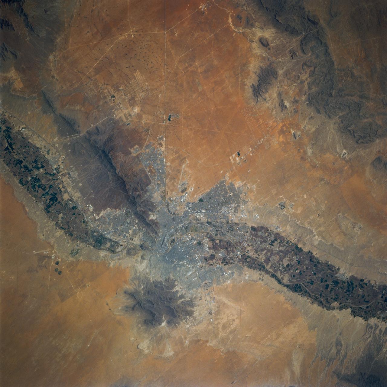
STS078-742-051 (20 June - 7 July 1996) --- One of the crew members aboard the Space Shuttle Columbia in Earth-orbit photographed this space to Earth view of Madrid, the capital of Spain as well as that country’s largest city. Madrid represents the national center of arts and industry. It is located in the center of the photo and is difficult to see because it blends into the surrounding colors. It was in 1607 that Philip III officially made the city the national capital, a status it has retained ever since. Under the patronage of Philip and his successors, Madrid developed into a city of curious contrasts, preserving its old, overcrowded center, around which developed palaces, convents, churches, and public buildings. Madrid lies almost exactly at the geographical heart of the Iberian Peninsula, near the Carpetovetonica Range. It is situated on an undulating plateau of sand and clay known as the Meseta (derived from the Spanish word mesa, or "table") at an altitude of 2,100 feet (635 meters) above sea level, making it one of the highest capitals in Europe. It is not on a major river, in the way that so many European cities are, but is on a smaller river, the Manzanares.

NASA Dryden Mission Manager Walter Klein poses with school children that visited the airport during AirSAR 2004. In spanish, he explained to them the mission of the DC-8 AirSAR 2004 Mesoamerican campaign in Costa Rica. AirSAR 2004 Mesoamerica is a three-week expedition by an international team of scientists that uses an all-weather imaging tool, called the Airborne Synthetic Aperture Radar (AirSAR) which is located onboard NASA's DC-8 airborne laboratory. Scientists from many parts of the world including NASA's Jet Propulsion Laboratory are combining ground research done in several areas in Central America with NASA's AirSAR technology to improve and expand on the quality of research they are able to conduct. The radar, developed by NASA's Jet Propulsion Laboratory, can penetrate clouds and also collect data at night. Its high-resolution sensors operate at multiple wavelengths and modes, allowing AirSAR to see beneath treetops, through thin sand, and dry snow pack. AirSAR's 2004 campaign is a collaboration of many U.S. and Central American institutions and scientists, including NASA; the National Science Foundation; the Smithsonian Institution; National Geographic; Conservation International; the Organization of Tropical Studies; the Central American Commission for Environment and Development; and the Inter-American Development Bank.
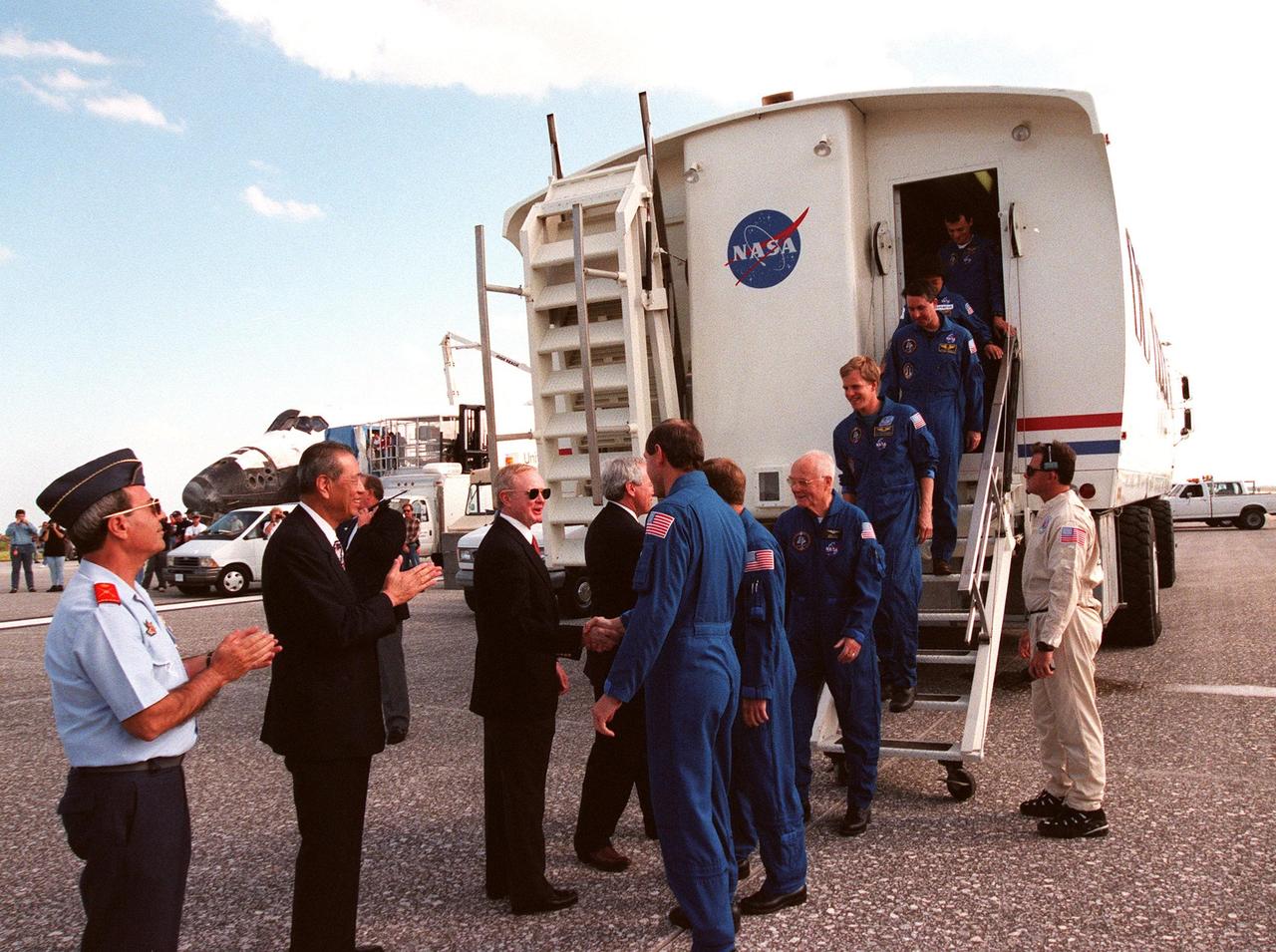
Following touchdown at 12:04 p.m. EST at the Shuttle Landing Facility, the STS-95 crew leave the Crew Transport Vehicle where they are met by (left to right) a Spanish dignitary; Isao Uchida, president of the National Space Development Agency of Japan (NASDA); Center Director Roy Bridges; and NASA Administrator Daniel Goldin. The crew, from left to right, are Mission Commander Curtis L. Brown Jr. (shaking hands with Bridges); Pilot Steven W. Lindsey; Payload Specialist John H. Glenn Jr., a senator from Ohio and one of the original Mercury 7 astronauts; Mission Specialist Scott E. Parazynski; Mission Specialist Stephen K. Robinson; Payload Specialist Chiaki Mukai, with the National Space Development Agency of Japan (NASDA); and Mission Specialist Pedro Duque of Spain, with the European Space Agency (ESA). The successful mission lasted nine days and included research payloads such as the Spartan solar-observing deployable spacecraft, the Hubble Space Telescope Orbital Systems Test Platform, the International Extreme Ultraviolet Hitchhiker, as well as the SPACEHAB single module with experiments on space flight and the aging process
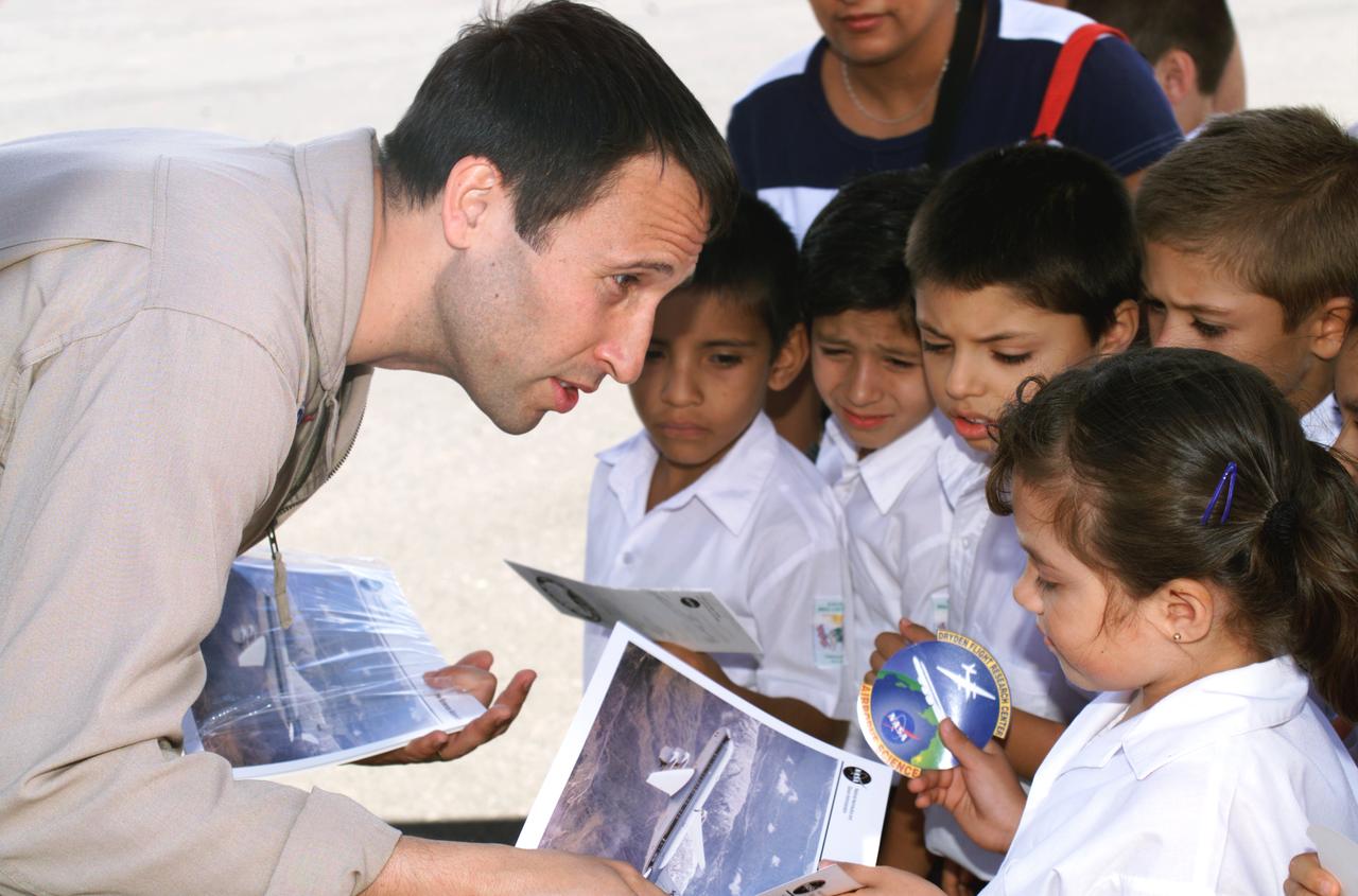
NASA Dryden Mission Manager Walter Klein passes out Airborne Science stickers and lithographs to underprivileged school children that visited the airport on Monday March 8, 2004. In spanish, he explained to them the mission of the DC-8 AirSAR 2004 Mesoamerican campaign in Costa Rica. AirSAR 2004 Mesoamerica is a three-week expedition by an international team of scientists that uses an all-weather imaging tool, called the Airborne Synthetic Aperture Radar (AirSAR) which is located onboard NASA's DC-8 airborne laboratory. Scientists from many parts of the world including NASA's Jet Propulsion Laboratory are combining ground research done in several areas in Central America with NASA's AirSAR technology to improve and expand on the quality of research they are able to conduct. The radar, developed by NASA's Jet Propulsion Laboratory, can penetrate clouds and also collect data at night. Its high-resolution sensors operate at multiple wavelengths and modes, allowing AirSAR to see beneath treetops, through thin sand, and dry snow pack. AirSAR's 2004 campaign is a collaboration of many U.S. and Central American institutions and scientists, including NASA; the National Science Foundation; the Smithsonian Institution; National Geographic; Conservation International; the Organization of Tropical Studies; the Central American Commission for Environment and Development; and the Inter-American Development Bank.
Saint Croix is a district of the U.S. Virgin Islands, in the Caribbean Sea. First inhabited by indigenous groups, the island was visited by Columbus in 1493. By the end of the 16th century, the island was uninhabited, the native population dispersed or killed. Starting in the 17th century, the island was successively claimed by the Spanish, the French, the French West India Company, and, for the next 200 years, the Danish West India Company. In 1801 the British invaded and took control; followed by Denmark-Norway a year later. Then again the British, and again Denmark in 1815. One hundred years later, in 1915, Denmark sold the Virgin Islands to the United States, and the inhabitants were granted US citizenship. Saint Croix was home to HOVENSA, one of the world's largest oil refineries. In 2012, the refinery closed, and tourism is now the main source of revenue (Wikipedia). The image covers an area of 18.7 by 36.2 km, was acquired March 10, 2011, and is located at 17.7 degrees north, 64.7 degrees west. https://photojournal.jpl.nasa.gov/catalog/PIA22894
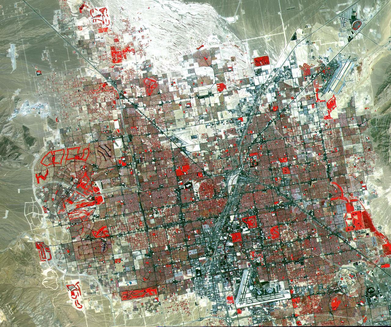
This image of Las Vegas, NV was acquired on August, 2000 and covers an area 42 km (25 miles) wide and 30 km (18 miles) long. The image displays three bands of the reflected visible and infrared wavelength region, with a spatial resolution of 15 m. McCarran International Airport to the south and Nellis Air Force Base to the NE are the two major airports visible. Golf courses appear as bright red areas of worms. The first settlement in Las Vegas (which is Spanish for The Meadows) was recorded back in the early 1850s when the Mormon church, headed by Brigham Young, sent a mission of 30 men to construct a fort and teach agriculture to the Indians. Las Vegas became a city in 1905 when the railroad announced this city was to be a major division point. Prior to legalized gambling in 1931, Las Vegas was developing as an agricultural area. Las Vegas' fame as a resort area became prominent after World War II. The image is located at 36.1 degrees north latitude and 115.1 degrees west longitude. http://photojournal.jpl.nasa.gov/catalog/PIA11096

NASA Dryden Mission Manager Walter Klein passes out Airborne Science stickers and lithographs to underprivileged school children that visited the airport on Monday March 8, 2004. In spanish, he explained to them the mission of the DC-8 AirSAR 2004 Mesoamerican campaign in Costa Rica. AirSAR 2004 Mesoamerica is a three-week expedition by an international team of scientists that uses an all-weather imaging tool, called the Airborne Synthetic Aperture Radar (AirSAR) which is located onboard NASA's DC-8 airborne laboratory. Scientists from many parts of the world including NASA's Jet Propulsion Laboratory are combining ground research done in several areas in Central America with NASA's AirSAR technology to improve and expand on the quality of research they are able to conduct. The radar, developed by NASA's Jet Propulsion Laboratory, can penetrate clouds and also collect data at night. Its high-resolution sensors operate at multiple wavelengths and modes, allowing AirSAR to see beneath treetops, through thin sand, and dry snow pack. AirSAR's 2004 campaign is a collaboration of many U.S. and Central American institutions and scientists, including NASA; the National Science Foundation; the Smithsonian Institution; National Geographic; Conservation International; the Organization of Tropical Studies; the Central American Commission for Environment and Development; and the Inter-American Development Bank.
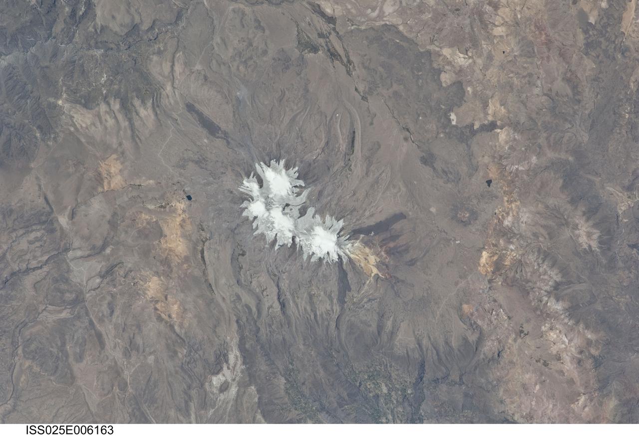
ISS025-E-006163 (6 Oct. 2010) --- Nevado Coropuna, Peru is featured in this image photographed by an Expedition 25 crew member on the International Space Station. Nevado (“snowy” or “snowy peak” in Spanish) Coropuna is the highest volcanic peak in Peru – the summit elevation is 6,377 meters above sea level. Rather than being a single stratovolcano, Coropuna is a volcanic complex of numerous summit cones. The complex covers an area of 240 square kilometers within the Ampato mountain range (Cordillera Ampato) in southeast-central Peru. While the exact date of the volcano’s last eruption is not known, lava flows (black, at center and upper left) along the northern, southern, and western flanks of the complex are thought to have been emplaced during the early Holocene Epoch – the current geologic time period which began approximately 12,000 years ago, according to scientists. Coropuna also hosts several summit glaciers and icefields (white to gray, center) that contrast sharply with the dark rock outcrops and surface deposits at lower elevations. Glacial deposits and lateral moraines on the flanks of Coropuna indicate that glaciers once extended to much lower elevations than are observed today. Scientists believe that careful mapping and surface exposure age-dating of these glacial deposits and landforms provides data on the timing of ice advances and retreats in the tropics near the end of the Pleistocene Epoch (extending from approximately 2.5 million to approximately 12,000 years ago). In turn, this information can be compared with other paleoclimate records to obtain a better understanding of how Earth’s global climate has changed over geologic time.
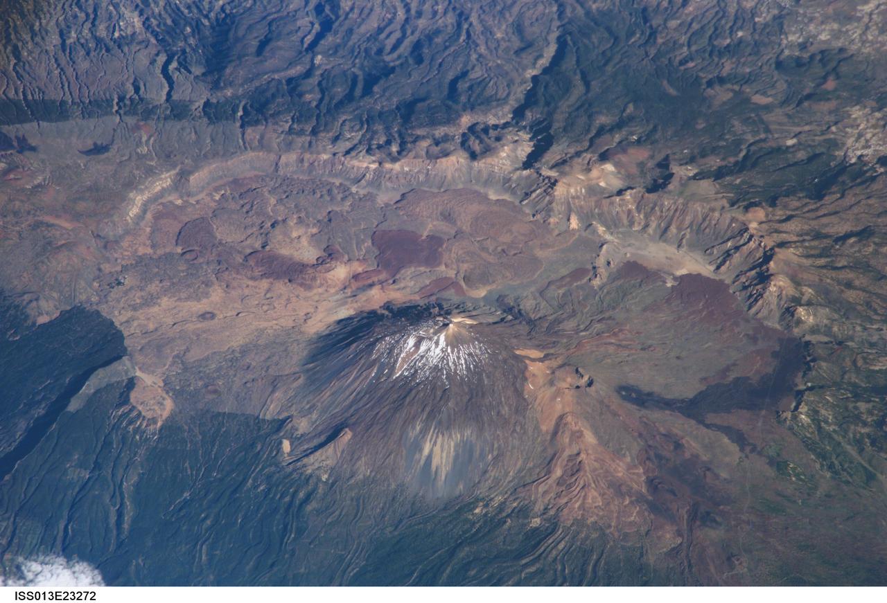
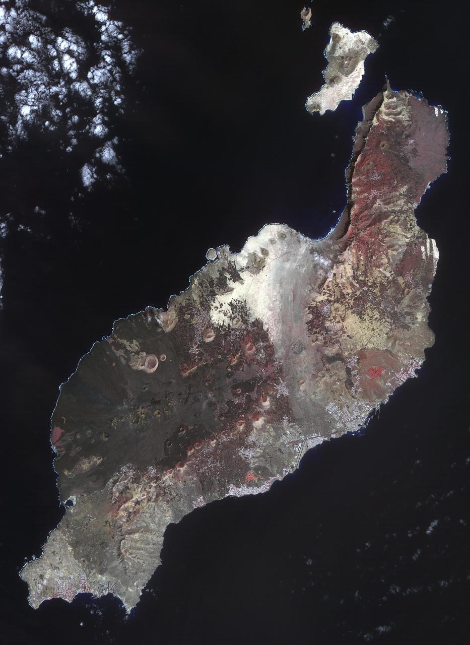
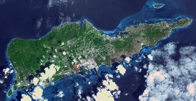
ISS013-E-23272 (8 June 2006) --- Tenerife Island, Spain is featured in this image photographed by an Expedition 13 crewmember on the International Space Station. Tenerife is the largest of the Canary Islands, a Spanish possession located off the northwestern coast of Africa. According to scientists, the islands in the chain could have been produced by eruptions of basaltic shield volcanoes as the African tectonic plate moved over a stationary "hot spot" much like the formation of the Hawaiian Islands. A different hypothesis relates the Canary Islands to magma rise along underwater faults during the uplift of the Atlas Mountains in northern Africa. The island of Tenerife exhibits many excellent volcanic features. The central feature of this image is the elliptical depression of the Las Ca?adas caldera that measures 170 square kilometers in area. A caldera is typically formed when the magma chamber underneath a volcano is completely emptied (usually following a massive eruptive event), and the overlying materials collapse into the newly formed void beneath the surface. A large landslide may have also contributed to (or been the primary cause of) formation of the caldera structure. In this model, part of the original shield volcano forming the bedrock of the island collapsed onto the adjacent sea floor, forming the large depression of the caldera. According to scientists, following formation of the caldera approximately 0.17 million years ago, the composite volcanoes of Mount Teide and Pico Viejo formed. Teide is the highest peak in the Atlantic Ocean with a summit elevation of 3,715 meters. This type of volcano is formed by alternating layers of dense lava flows and more fragmented explosive eruption products, and can build high cones. Many linear flow levees are visible along the flanks of Teide volcano extending from the summit to the base, while a large circular explosion crater marks the summit of Pico Viejo. The floor of the Las Ca?adas caldera is covered with tan, red-brown, and black irregularly-lobed lava flows, the eruptions of which have been observed by settlers and seamen since 1402. The most recent eruption occurred in 1909. The island of Tenerife is actively monitored for further activity.
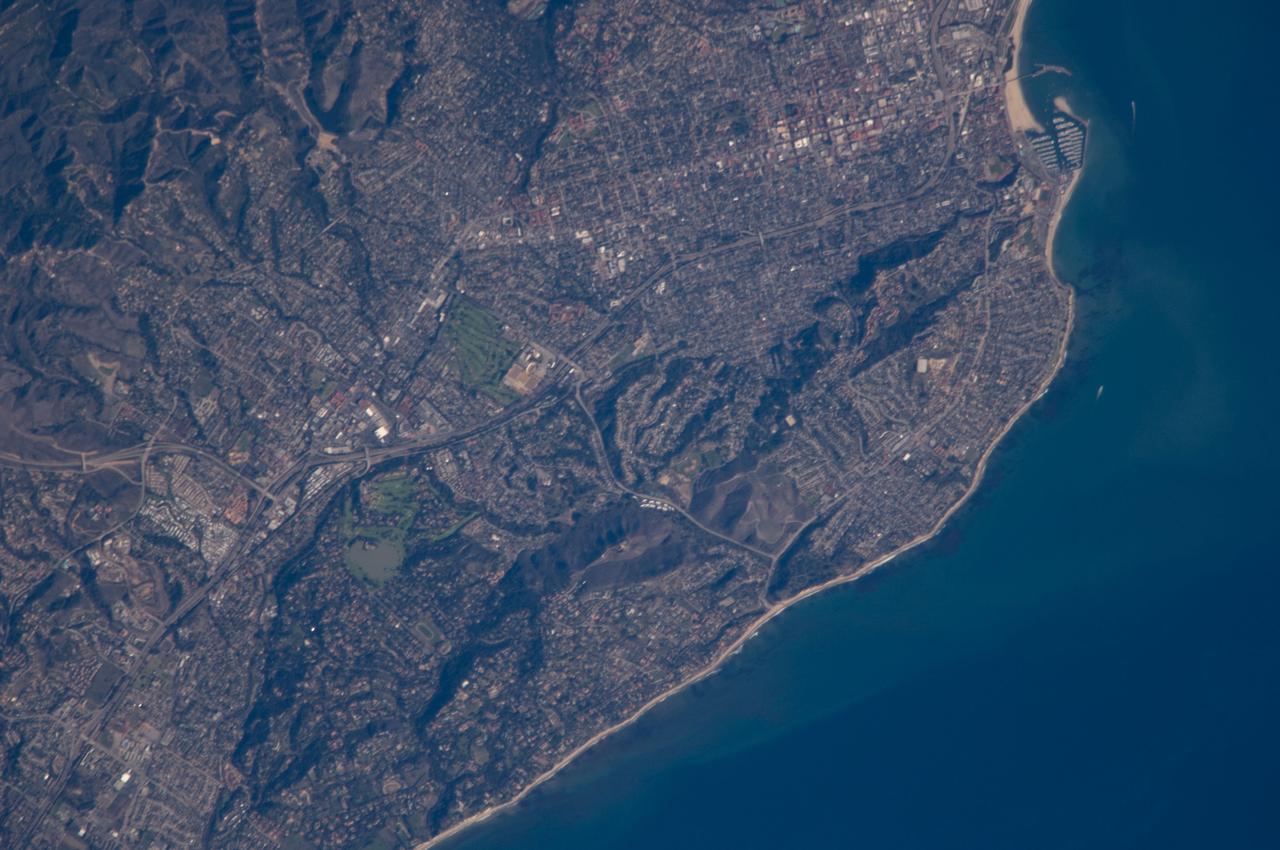
ISS018-E-011096 (6 Dec. 2008) --- Santa Barbara, CA metropolitan area, also known as the ?American Riviera?, is featured in this image photographed by an Expedition 18 crewmember on the International Space Station. The geographic setting of the city - between the Santa Barbara Channel to the south and the steep Santa Ynez Mountains to the north. The city was officially founded as a Spanish mission in 1786, and was incorporated into the United States from Mexico in 1848 following the Mexican-American War. The dramatic landscape of the city is the result of tectonic forces ? the Santa Barbara Channel is part of the boundary between the Pacific oceanic and North American continental crustal plates. Movement along the San Andreas Fault ? the actual zone of contact between the two plates ? over geologic time both raised the Santa Ynez range and lowered the seafloor, forming the deep Santa Barbara Channel. The city has experienced two earthquakes, one in 1812 and another in 1925 that caused significant damage. The urban street grid is defined by white and red rooftops at top center; to the southeast lie beaches and the boat slips of a large marina (top right). Two large golf courses, characterized by expanses of green grass, are visible at center. Low east-west trending hills that parallel the coastline are almost completely covered by residential and commercial development, lending a speckled appearance to the hillsides. Immediately offshore, giant kelp beds are the focus of the Santa Barbara Coastal Long Term Ecological Research site, part of the National Science Foundation?s Long Term Ecological Research Network.
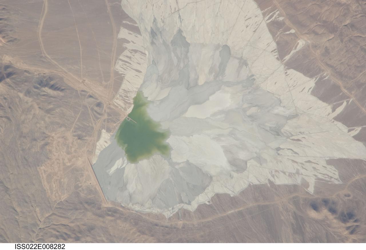
ISS022-E-008282 (9 Dec. 2009) --- One of the world?s leading copper mines, Escondida, in the Atacama Desert of Chile, is featured in this image photographed by an Expedition 22 crew member on the International Space Station. The copper mining industry is a major part of the Chilean economy. The mine is located 170 kilometers southeast of Chile?s port city of Antofagasta, in the hyper arid northern Atacama Desert at an elevation of 3,050 meters (approximately 10,000 feet) above sea level. Escondida produces mainly copper concentrates; assisted by gravity, the concentrates are piped as slurry down to the smaller port of Coloso just south of Antofagasta where they are dewatered for shipping. The photograph features a large light tan and gray waste or ?spoil? materials impoundment area (center) of the mine complex. The copper-bearing waste, which is a large proportion of the material excavated from open pits to the north (not in frame), is poured into the impoundment area as a liquid (green region at photo?s center), and dries to the lighter-toned spoil seen in the image. The spoil is held behind a retaining dam, just a little more than one kilometer in length, visible as a straight line at lower left. ?Escondida? means ?hidden? in Spanish, and refers to the fact that the copper ore body was buried beneath hundreds of meters of barren rock and had to be located by a laborious drilling program following a geologic trend established from other copper occurrences.

ISS017-E-008188 (29 May 2008) --- Dry Tortugas islands near Florida are featured in this image photographed by an Expedition 17 crewmember on the International Space Station. The Dry Tortugas are a group of islands located approximately 75 miles west of Key West, Florida; they form the western end of the Florida Keys in the Gulf of Mexico. Like the Keys, the Dry Tortugas are formed primarily of coral reefs over older limestone formations. The islands were named "Dry Tortugas" upon discovery by Ponce de Leon in 1513 -- "tortugas" means turtles in Spanish, and the islands are "dry" as no fresh water is found on them. From the air, the islands present an atoll-like arrangement, however no central volcanic structure is present. The islands are only accessible by boat or seaplane; nevertheless they have been designated the Dry Tortugas National Park, and are visited by hundreds every year. This view highlights three islands in the group; Bush Key, Hospital Key, and Garden Key -- the site of Fort Jefferson. Fort Jefferson is a Civil War era fort, perhaps most notable for being the prison of Dr. Samuel Mudd, who set the broken leg of John Wilkes Booth following Booth's assassination of President Lincoln. The fort itself is currently undergoing extensive restoration to prevent collapse of the hexagonal outer walls (center). The islands stand out due to brown and light tan carbonate sands visible above the Gulf of Mexico water surface. Light blue-green irregular masses in the image surrounding the islands are coral reef tops visible below the water surface.
The ruins of Machu Picchu, rediscovered in 1911 by Hiram Bingham, are one of the most beautiful and enigmatic ancient sites in the world. While the Inca people utilized the Andean mountain top (2800 m elevation), erecting massive stone structures from the early 1400's, legends and myths indicate that Machu Picchu (meaning "Old Peak" in the Quechua language) was revered as a sacred place from a far earlier time. The Inca turned the site into a small (12 square kilometers) but extraordinary city. Invisible from the Urubamba River valley below and completely self-contained, surrounded by agricultural terraces sufficient to feed the population, and watered by natural springs, Machu Picchu seems to have been utilized by the Inca as a secret ceremonial city. The Spaniards never found Machu Picchu, even though they suspected its existence. The mountain top sanctuary fell into disuse and was abandoned some forty years after the Spanish took Cuzco in 1533. Supply lines linking the many Inca social centers were disrupted and the great empire came to an end. This image was acquired on June 25, 2001 by the Advanced Spaceborne Thermal Emission and Reflection Radiometer (ASTER) on NASA's Terra satellite. With its 14 spectral bands from the visible to the thermal infrared wavelength region, and its high spatial resolution of 15 to 90 meters (about 50 to 300 feet), ASTER will image Earth for the next 6 years to map and monitor the changing surface of our planet. http://photojournal.jpl.nasa.gov/catalog/PIA03853

In January 2013, a new Earth-observing instrument was installed on the International Space Station (ISS). ISERV Pathfinder consists of a commercial camera, a telescope, and a pointing system, all positioned to look through the Earth-facing window of ISS’s Destiny module. ISERV Pathfinder is intended as an engineering exercise, with the long-term goal of developing a system for providing imagery to developing nations as they monitor natural disasters and environmental concerns. The image above is the “first light” from the new ISERV camera system, taken at 1:44 p.m. local time on February 16, 2013. It shows the Rio San Pablo as it empties into the Golfo de Montijo in Veraguas, Panama. It is an ecological transition zone, changing from agriculture and pastures to mangrove forests, swamps, and estuary systems. The area has been designated a protected area by the National Environmental Authority (ANAM) of Panama and is listed as a “wetland of international importance” under the Ramsar Convention. (Note that the image is rotated so that north is to the upper right.) “ISERV’s full potential is yet to be seen, but we hope it will really make a difference in people’s lives,” said principal investigator Burgess Howell of NASA’s Marshall Space Flight Center. “For example, if an earthen dam gives way in Bhutan, we want to be able to show officials where the bridge is out or where a road is washed out or a power substation is inundated. This kind of information is critical to focus and speed rescue efforts.” The instrument will be controlled from NASA Marshall in Huntsville, Alabama, in collaboration with researchers at hubs in Central America, East Africa, and the Hindu Kush–Himalaya region. They will rely on positioning software to know where the space station is at each moment and to calculate the next chance to view a particular area on the ground. If there's a good viewing opportunity, the SERVIR team will instruct the camera to take high-resolution photographs at 3 to 7 frames per second, totaling as many as 100 images per pass. With a resolution down to 3.2 meters (10 feet), it will be possible to spot fairly small details and objects. The current mission will test the limitations of Pathfinder and identify measures for improvements in a more permanent system. For instance, the engineering team is working to determine how the geometry of the ISS window affects the imagery; how much sunlight is needed to capture clear images; and how the atmosphere affects that clarity. This characterization phase will last several weeks to a few months. Eventually, ISERV should be made available to the natural hazards community and to basic research scientists. ISERV is short for ISS SERVIR Environmental Research and Visualization system. Together with the U.S. Agency for International Development, NASA runs the SERVIR program to provide satellite data, maps, and other tools to environmental decisionmakers in developing countries. (Servir is a Spanish word meaning “to serve.”) Learn more about the SERVIR program by clicking here: <a href="https://servirglobal.net/Global.aspx" rel="nofollow">servirglobal.net/Global.aspx</a> NASA image by Burgess Howell, SERVIR Global program. Caption by Dauna Coulter, NASA Marshall Space Flight Center, and Mike Carlowicz, NASA Earth Observatory. Instrument: ISS - ISERV Pathfinder Credit: <b><a href="http://www.earthobservatory.nasa.gov/" rel="nofollow"> NASA Earth Observatory</a></b> - <a href="http://1.usa.gov/12Aqmg9" rel="nofollow">1.usa.gov/12Aqmg9</a> <b><a href="http://www.nasa.gov/audience/formedia/features/MP_Photo_Guidelines.html" rel="nofollow">NASA image use policy.</a></b> <b><a href="http://www.nasa.gov/centers/goddard/home/index.html" rel="nofollow">NASA Goddard Space Flight Center</a></b> enables NASA’s mission through four scientific endeavors: Earth Science, Heliophysics, Solar System Exploration, and Astrophysics. Goddard plays a leading role in NASA’s accomplishments by contributing compelling scientific knowledge to advance the Agency’s mission. <b>Follow us on <a href="http://twitter.com/NASA_GoddardPix" rel="nofollow">Twitter</a></b> <b>Like us on <a href="http://www.facebook.com/pages/Greenbelt-MD/NASA-Goddard/395013845897?ref=tsd" rel="nofollow">Facebook</a></b> <b>Find us on <a href="http://instagram.com/nasagoddard?vm=grid" rel="nofollow">Instagram</a></b>