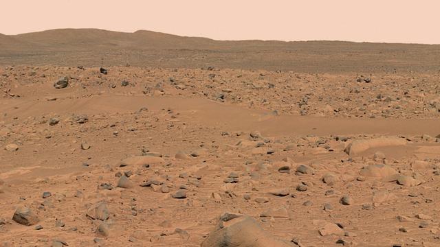
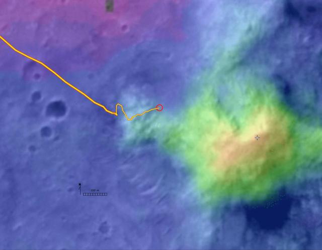
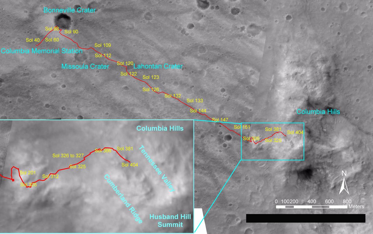
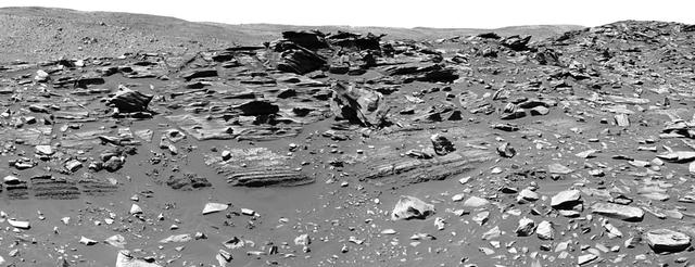
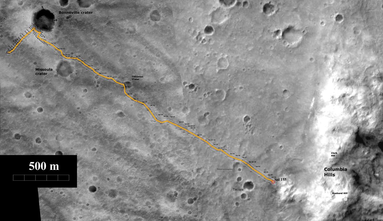
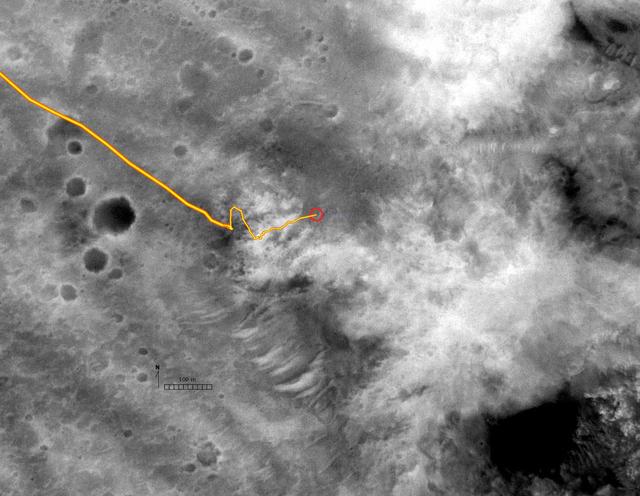
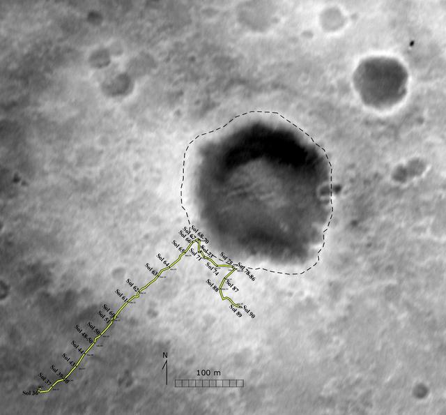
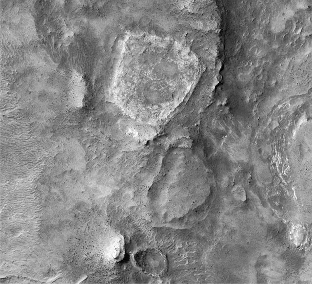
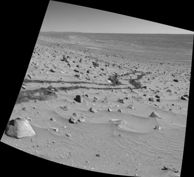
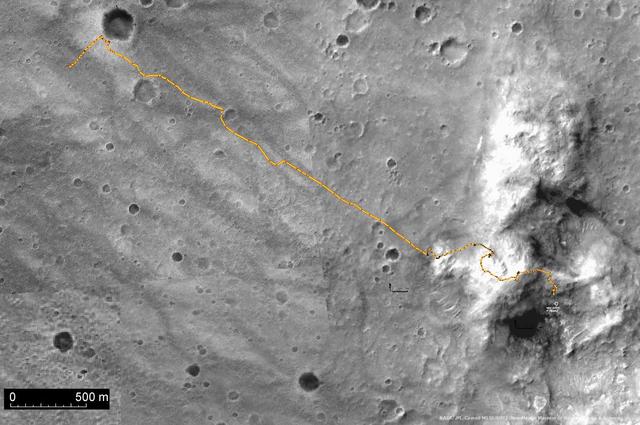
This frame from an animation flips back and forth between images taken before and after deployment of the Mars Exploration Rover Spirit's bogie, a part of the rover's suspension system that extends the wheel base. These images were taken by Spirit's hazard avoidance camera.  An animation is available at http://photojournal.jpl.nasa.gov/catalog/PIA05040
Spirit Stretches Out
NASA's Mars Exploration Rover Spirit used its navigation camera to take the images combined into this 360-degree view of the rover's surroundings on Spirit's 409th martian day, or sol (Feb. 26, 2005). Spirit had driven 2 meters (7 feet) on this sol to get in position on "Cumberland Ridge" for looking into "Tennessee Valley" to the east. This location is catalogued as Spirit's Site 108. Rover-wheel tracks from climbing the ridge are visible on the right. The summit of "Husband Hill" is at the center, to the south. This view is presented in a vertical projection with geometric and brightness seam correction.  http://photojournal.jpl.nasa.gov/catalog/PIA07410
Spirit 360-Degree View on Sol 409 (vertical)
NASA Mars Exploration Rover Spirit used its navigation camera to capture this view of the terrain toward the southeast from the location Spirit reached on the 1,871st Martian day, or sol, of the rover mission on Mars April 8, 2009.   The mound on the horizon in the upper left is informally called "Von Braun" and is one of the features that rover team has designated as a possible investigation site in future months. From the location where Spirit was when the image was taken, Von Braun is about 160 meters (525 feet) away.   http://photojournal.jpl.nasa.gov/catalog/PIA11996
Von Braun Mound in Spirit Drive Direction
Wheel slippage during attempts to extricate NASA's Mars Rover Spirit from a patch of soft ground during the preceding two weeks had partially buried the wheels by the 1,899th Martian day, or sol, of the Spirit's mission on Mars (May 6, 2009).  Spirit took this image with its front hazard-avoidance camera on Sol 1899. With Spirit in the position shown here, the rover team temporarily suspended driving attempts while studying the ground around Spirit and planning simulation tests of driving options with a test rover at NASA's Jet Propulsion Laboratory in Pasadena, Calif.  Driving attempts between the time Spirit took a similar image (PIA12002) 10 sols earlier and when this image was taken moved the rover a total of about 36 centimeters (14 inches).  While driving backwards, the rover drags its right front wheel, which no longer rotates. For scale, the distance between the wheel tracks is about 1 meter (40 inches). This view is looking northward, with Husband Hill on the horizon.  http://photojournal.jpl.nasa.gov/catalog/PIA12007
Spirit Wheels Digging into Soft Ground, Sol 1899
This frame from an animation shows the perspective from the navigation camera on the Mars Exploration Rover Spirit before its automated stand-up process. After standing up, the rover is approximately 12 inches higher off of the lander, resulting in a better view of the surrounding terrain.   An animation is available at http://photojournal.jpl.nasa.gov/catalog/PIA05032
From Spirit's Perspective
NASA's Mars Exploration Rover Spirit drove 6.98 meters (22.9 feet) southeastward on the 1,871st Martian day, or sol, of the rover's mission on Mars (April 8, 2009). As usual since losing the use of its right-front wheel in 2006, Spirit drove backward, dragging the immobile wheel. The rover used its front hazard-avoidance camera after the drive to capture this view looking back at the ground covered.  For scale, the distance between the parallel wheel tracks is about 1 meter (40 inches).  The drive added to progress in trekking counterclockwise around a low plateau called "Home Plate." Spirit is driving through a valley on the west side of the plateau. Home Plate is not within this image. The hill on the horizon in the upper right is Husband Hill, the summit of which is about 750 meters (nearly half a mile) to the north of Spirit's position. Following this drive, Spirit experienced difficulties that prevented driving during the subsequent week.  http://photojournal.jpl.nasa.gov/catalog/PIA11990
After a Spirit Drive West of Home Plate
NASA's Mars Exploration Rover Spirit slipped in soft ground during short backward drives on the 1,886th and 1,889th Martian days, or sols, of the rover's mission on Mars (April 23 and 26, 2009). Spirit used its front hazard-avoidance camera after driving on Sol 1889 to get this wide-angle view, which shows the soil disturbed by the drives.  Spirit drove 1.11 meters (3.6 feet) on Sol 1889 and 1.68 meters (5.5 feet) on Sol 1886. The rover drags its right front wheel, which no longer rotates. For scale, the distance between the wheel tracks is about 1 meter (40 inches).  This view is looking northward, with Husband Hill on the horizon.   http://photojournal.jpl.nasa.gov/catalog/PIA12002
Spirit Slipping in Soft Ground, Sol 1889
Spirit Digs In
Spirit Digs In
Spirit Course
Spirit Course
Spirit Travels
Spirit Travels
Spirit Destination
Spirit Destination
This digital elevation map, produced from satellite data overlain on an image taken by the Mars Orbital Camera on NASA's Mars Global Surveyor spacecraft, shows changes in elevation along the trek of NASA's Mars Exploration Rover Spirit as of the rover's 328th martian day, or sol (Dec. 4, 2004). To that point, Spirit had driven a total of 3.89 kilometers (2.42 miles).      The blue area represents the basaltic plains on the floor of Gusev Crater, about 20 meters (66 feet) below the rover's present location. Spirit crossed those plains for several months after landing to the west, off the left edge of this image. The greenish-blue area is the "West Spur" of the "Columbia Hills," which Spirit reached on sol 156 (June 11, 2004). Since then, Spirit has been gradually ascending the slopes of the "West Spur" in an east-northeasterly direction. Southeast of the rover's current position is a brighter green area that represents an abrupt increase in slope where the "West Spur" meets the steeper flanks of the "Columbia Hills." The yellow and red areas represent the highest slopes and peaks. A steep valley east of the rover's location appears, from orbiter images, to have layered outcrops. Scientists are directing the rover to a ridge overlooking the valley to get a better look at what lies ahead.  http://photojournal.jpl.nasa.gov/catalog/PIA07089
Digital Elevation Map of Spirit Trek
NASA's Mars Exploration Rover Spirit drove a total of 4,143 meters (2.57 miles) between its landing in January 2004 and its 404th martian day, or sol (Feb. 20, 2005). This map on an image taken by the Mars Orbiter Camera on NASA's Mars Global Surveyor shows the course the rover drove during that time. The rover has recently been approaching a ridge overlooking "Tennessee Valley" on the north flank of "Husband Hill."   http://photojournal.jpl.nasa.gov/catalog/PIA07393
Spirit Traverse Map, Sol 404
Spirit Heads Toward History
Spirit Digs a Trench
Spirit View on Sol 147
Spirit Descent to Mars-1983
Spirit View on Sol 110
Spirit Spies Wavy Bedforms
View in Front of Spirit
Spirit Self-motivates
Spirit Hits a Home Run
Dusty Solar Panels on Spirit
Dust Devils Seen by Spirit
Spirit Sol 154, Driving By
Spirit Leaves Telling Tracks
Spirit Prime-Mission Traverse
A Flyby Tour of Spirit Descent
First Look Behind Spirit
Spirit View on Sol 142
Spirit Extended-Mission Destination
Way to Go Spirit!
Way to Go Spirit!
Spirit Beholds Bumpy Boulder
Spirit Lightens the Load
Spirit Wiggles into Position
Spirit View on Sol 107
Spirit Moves in on Columbia Hills
Spirit Winter Work Site
Spirit Guidepost, Plymouth Rock
Spirit Has Flower Power
Spirit View on Sol 148
Plains and Hills Explored by Spirit
Spirit has Landed!
Spirit has Landed!
Spirit Looks Back
Spirit Looks Back
Spirit Rover on Husband Hill
Spirit View on Sol 399
Peace Rock Viewed by Spirit
Spirit Surroundings on Sol 337
Spirit Keeps on Trekking
First Look at Spirit on Mars
Spirit Airbags Leave Trail
Spirit Keeps Rolling
Spirit West Valley Panorama
Apollinaris, Gusev, and Spirit
Spirit Back at Work
Spirit Back at Work
Location of Spirit Home
Spirit Successful Landing
Approximate Location of Spirit
Spirit Shadow, Sol 153
Spirit Sees Salty Soil
Spirit View of Larry Outcrop
Hills Explored by Spirit
Spirit, Too, Finds Hematite
Spirit Descent to Mars-1706
Spirit Winter Home
Spirit Winter Home
Spirit Descent to Mars-1433
Spirit Traverse Map
Spirit Traverse Map
Spirit View on Sol 390
Spirit View of Columbia Hills
Spirit Surroundings on Sol 337
Lessons from Spirit Landing
Spirit Feels Dust Gust
Spirit Reaches for Closer Look
Spirit is Out the Gate
Spirit Plan for Columbia Hills
Spirit Destination panorama
Spirit Route in Black and White
Spirit View on Sol 123
A Dynamic Spirit Site
Spirit Path to Bonneville
Spirit Landing Site in Infrared
Spirit Trip to the Hills
This scene from the panoramic camera (Pancam) on NASA's Mars Exploration Rover Opportunity shows "Spirit Mound" overlooking the floor of Endeavour Crater. The mound stands near the eastern end of "Bitterroot Valley" on the western rim of the crater, and this view faces eastward.  For scale, the two rocks at lower center are each about 8 inches (about 20 centimeters) across. At the mound's crest line, the image covers an area about 28 feet (about 8.5 meters) wide.  The component images for this mosaic were taken on Sept. 21, 2016, during the 4,501st Martian day, or sol, of Opportunity's work on Mars. Exposures were taken through three of the Pancam's color filters, centered on wavelengths of 753 nanometers (near-infrared), 535 nanometers (green) and 432 nanometers (violet). The scene is presented here in approximately true color.  The informal name the rover's science team chose for this feature refers to Spirit Mound in South Dakota. The team is using names of sites visited by the Lewis and Clark Expedition as informal names for features in Mars' Bitterroot Valley (named for a valley that the expedition visited in Montana).  http://photojournal.jpl.nasa.gov/catalog/PIA20851
Spirit Mound at Edge of Endeavour Crater, Mars
This stereo scene from NASA's Mars Exploration Rover Opportunity shows "Spirit Mound" overlooking the floor of Endeavour Crater. The mound stands near the eastern end of "Bitterroot Valley" on the western rim of the crater, and this view faces eastward.  The image combines views from the left eye and right eye of the rover's panoramic camera (Pancam) to appear three-dimensional when seen through blue-red glasses with the red lens on the left. The component images were taken on Sept. 21, 2016, during the 4,501st Martian day, or sol, of Opportunity's work on Mars  For scale, the two rocks at lower center are each about 8 inches (about 20 centimeters) across. At the mound's crest line, the image covers an area about 28 feet (about 8.5 meters) wide.  The informal name the rover's science team chose for this feature refers to Spirit Mound in South Dakota. The team is using names of sites visited by the Lewis and Clark Expedition as informal names for features in Mars' Bitterroot Valley (named for a valley that the expedition visited in Montana).  http://photojournal.jpl.nasa.gov/catalog/PIA20853
Spirit Mound at Edge of Endeavour Crater, Mars (Anaglyph)
Spirit Hardware Up Close on Mars
Spirit View on Sol 147 Vertical
Spirit View on Sol 101 vertical
Spirit Heads Toward History vertical
Looking Back, Spirit Sol 90
Hills Still a Distant Goal for Spirit
Spirit Looks Back on Sol 332
Spirit View on Sol 399 Vertical
Spirit View on Sol 93 vertical
Spirit View on Sol 399 Polar
Spirit Mission From Beginning to End
Spirit View on Sol 100 vertical
Spirit View on Sol 124 vertical
Silica-Rich Soil Found by Spirit
Spirit Begins Third Martian Year
Recovering Spirit Sends a New Picture