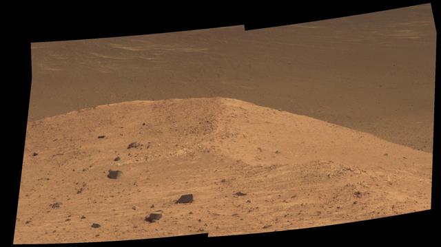
This scene from the panoramic camera (Pancam) on NASA's Mars Exploration Rover Opportunity shows "Spirit Mound" overlooking the floor of Endeavour Crater. The mound stands near the eastern end of "Bitterroot Valley" on the western rim of the crater, and this view faces eastward. For scale, the two rocks at lower center are each about 8 inches (about 20 centimeters) across. At the mound's crest line, the image covers an area about 28 feet (about 8.5 meters) wide. The component images for this mosaic were taken on Sept. 21, 2016, during the 4,501st Martian day, or sol, of Opportunity's work on Mars. Exposures were taken through three of the Pancam's color filters, centered on wavelengths of 753 nanometers (near-infrared), 535 nanometers (green) and 432 nanometers (violet). The scene is presented here in approximately true color. The informal name the rover's science team chose for this feature refers to Spirit Mound in South Dakota. The team is using names of sites visited by the Lewis and Clark Expedition as informal names for features in Mars' Bitterroot Valley (named for a valley that the expedition visited in Montana). http://photojournal.jpl.nasa.gov/catalog/PIA20851
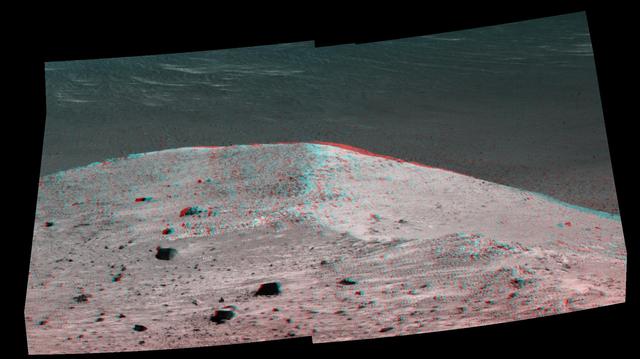
This stereo scene from NASA's Mars Exploration Rover Opportunity shows "Spirit Mound" overlooking the floor of Endeavour Crater. The mound stands near the eastern end of "Bitterroot Valley" on the western rim of the crater, and this view faces eastward. The image combines views from the left eye and right eye of the rover's panoramic camera (Pancam) to appear three-dimensional when seen through blue-red glasses with the red lens on the left. The component images were taken on Sept. 21, 2016, during the 4,501st Martian day, or sol, of Opportunity's work on Mars For scale, the two rocks at lower center are each about 8 inches (about 20 centimeters) across. At the mound's crest line, the image covers an area about 28 feet (about 8.5 meters) wide. The informal name the rover's science team chose for this feature refers to Spirit Mound in South Dakota. The team is using names of sites visited by the Lewis and Clark Expedition as informal names for features in Mars' Bitterroot Valley (named for a valley that the expedition visited in Montana). http://photojournal.jpl.nasa.gov/catalog/PIA20853
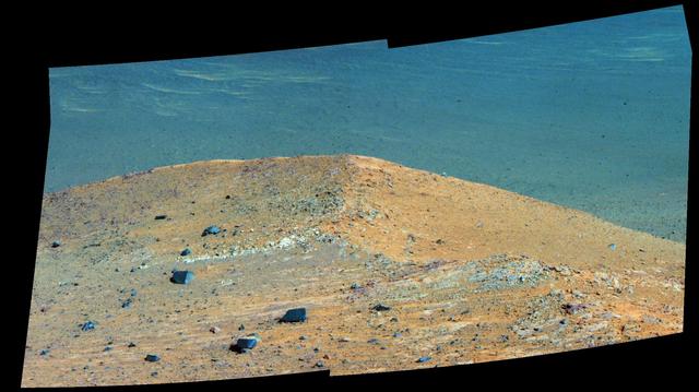
This scene from the panoramic camera (Pancam) on NASA's Mars Exploration Rover Opportunity shows "Spirit Mound" overlooking the floor of Endeavour Crater. The mound stands near the eastern end of "Bitterroot Valley" on the western rim of the crater, and this view faces eastward. In this version of the scene the landscape is presented in enhanced color to make differences in surface materials more easily visible For scale, the two rocks at lower center are each about 8 inches (about 20 centimeters) across. At the mound's crest line, the image covers an area about 28 feet (about 8.5 meters) wide. The component images for this mosaic were taken on Sept. 21, 2016, during the 4,501st Martian day, or sol, of Opportunity's work on Mars. Exposures were taken through three of the Pancam's color filters, centered on wavelengths of 753 nanometers (near-infrared), 535 nanometers (green) and 432 nanometers (violet). The informal name the rover's science team chose for this feature refers to Spirit Mound in South Dakota. The team is using names of sites visited by the Lewis and Clark Expedition as informal names for features in Mars' Bitterroot Valley (named for a valley that the expedition visited in Montana). http://photojournal.jpl.nasa.gov/catalog/PIA20852
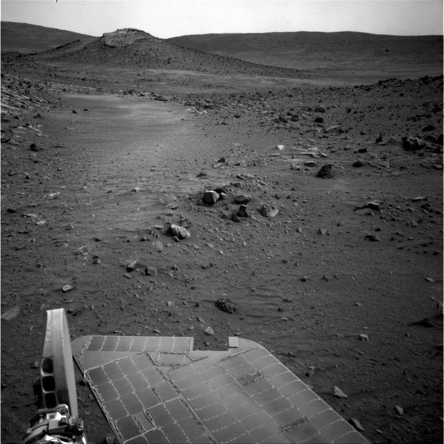
NASA Mars Exploration Rover Spirit used its navigation camera to capture this view of the terrain toward the southeast from the location Spirit reached on the 1,871st Martian day, or sol, of the rover mission on Mars April 8, 2009. The mound on the horizon in the upper left is informally called "Von Braun" and is one of the features that rover team has designated as a possible investigation site in future months. From the location where Spirit was when the image was taken, Von Braun is about 160 meters (525 feet) away. http://photojournal.jpl.nasa.gov/catalog/PIA11996

This relatively bright outcropping of rock, dubbed "Gasconade," was investigated by NASA's Mars Exploration Rover Opportunity while the rover was perched on "Spirit Mound" at the western edge of Mars' Endeavour Crater. This mosaic combines four frames taken by the microscopic imager on Opportunity's robotic arm on Oct. 2, 2016, during the 4,512st Martian day, or sol, of the rover's work on Mars. Enhanced color information from Opportunity's panoramic camera has been added to emphasize differences in the materials visible in the target. Figure A is a version with no color information added to the microscopic imager mosaic. The view covers an area about 2 inches (5 centimeters) wide. Opportunity's inspection found Gasconade to be a wind-etched outcrop with angular bits of darker rock within a lighter matrix, which may have been formed from fallout of the impact event that excavated the crater. This location of Spirit Mound, shown at PIA20854, is the deeper on the western rim of Endeavour Crater than any site visited previously by Opportunity. http://photojournal.jpl.nasa.gov/catalog/PIA21141
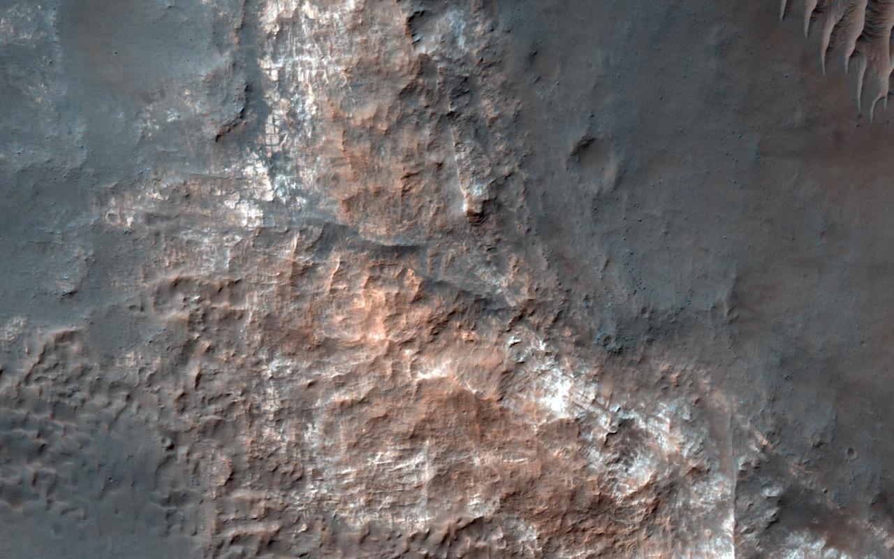
This image from NASA's Mars Reconnaissance Orbiter shows Gorgonum Basin, one of several large basins within the Terra Sirenum region of Mars. Each basin has light-toned mounds, many of which contain clays. Scientists think that Terra Sirenum once had a large lake during an epoch called the Late Noachian/Early Hesperian, and each basin filled with sediments. The water within the lake may have altered these sediments to form the clays we now observe from orbit. Ma'adim Vallis, which drains into Gusev Crater where the Spirit rover landed, drained the water from this ancient lake. Why the basin floors exhibit mounds similar to chaos regions on Mars is unknown, but could be the result of collapse and subsequent erosion within the basins. https://photojournal.jpl.nasa.gov/catalog/PIA21767