
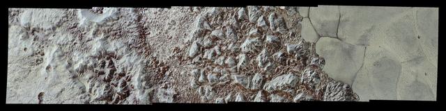
Sputnik Planum is the informal name of the smooth, light-bulb shaped region on the left of this composite of several of NASA New Horizons images of Pluto.
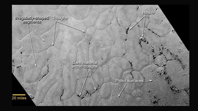
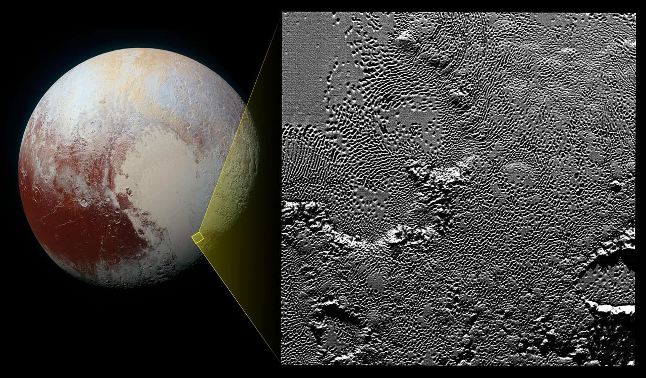
This annotated view of a portion of Pluto's Sputnik Planum (Sputnik Plain), named for Earth's first artificial satellite, shows an array of enigmatic features. The surface appears to be divided into irregularly shaped segments that are ringed by narrow troughs, some of which contain darker materials. Features that appear to be groups of mounds and fields of small pits are also visible. This image was acquired by the Long Range Reconnaissance Imager (LORRI) on July 14 from a distance of 48,000 miles (77,000 kilometers). Features as small as a half-mile (1 kilometer) across are visible. The blocky appearance of some features is due to compression of the image. http://photojournal.jpl.nasa.gov/catalog/PIA19714

This high-resolution image captured by NASA's New Horizons spacecraft combines blue, red and infrared images taken by the Ralph/Multispectral Visual Imaging Camera (MVIC). The bright expanse is the western lobe of the "heart," informally called Sputnik Planum, which has been found to be rich in nitrogen, carbon monoxide and methane ices. http://photojournal.jpl.nasa.gov/catalog/PIA20007
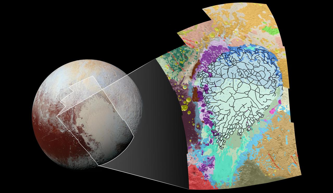
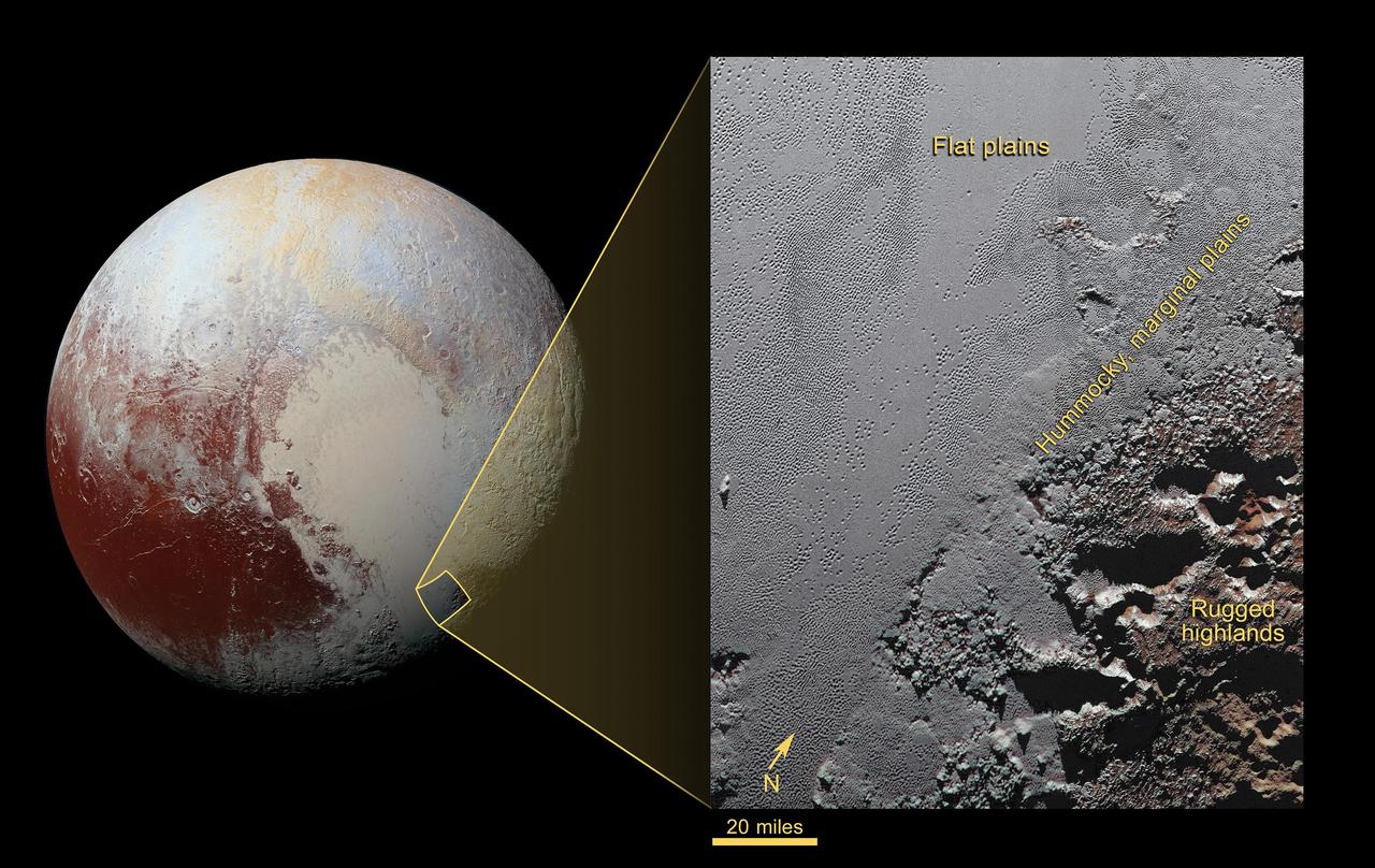
This geological map covers a portion of Pluto's surface that measures 1,290 miles (2,070 kilometers) from top to bottom, and includes the vast nitrogen-ice plain informally named Sputnik Planum and surrounding terrain. The map is overlain with colors that represent different geological terrains. Each terrain, or unit, is defined by its texture and morphology -- smooth, pitted, craggy, hummocky or ridged, for example. How well a unit can be defined depends on the resolution of the images that cover it. All of the terrain in this map has been imaged at a resolution of approximately 1,050 feet (320 meters) per pixel or better, meaning scientists can map units with relative confidence. The various blue and greenish units that fill the center of the map represent different textures seen across Sputnik Planum, from the cellular terrain in the center and north, to the smooth and pitted plains in the south. The black lines represent the troughs that mark the boundaries of cellular regions in the nitrogen ice. The purple unit represents the chaotic, blocky mountain ranges that line Sputnik's western border, and the pink unit represents the scattered, floating hills at its eastern edge. The possible cryovolcanic feature informally named Wright Mons is mapped in red in the southern corner of the map. The rugged highlands of the informally named Cthulhu Regio is mapped in dark brown along the western edge, and is pockmarked by many large impact craters, mapped in yellow. The base map for this geologic map is a mosaic of 12 images obtained by the Long Range Reconnaissance Imager (LORRI) at a resolution of 1,280 feet (about 390 meters) per pixel. The mosaic was obtained at a range of approximately 48,000 miles (77,300 kilometers) from Pluto, about an hour and 40 minutes before New Horizons' closest approach on July 14, 2015. http://photojournal.jpl.nasa.gov/catalog/PIA20465

This image contains the initial, informal names being used by NASA's New Horizons team for the features on Pluto's Sputnik Planum (plain). Names were selected based on the input the team received from the Our Pluto naming campaign. Names have not yet been approved by the International Astronomical Union (IAU). For more information on the maps and feature naming, visit http://www.ourpluto.org/maps. http://photojournal.jpl.nasa.gov/catalog/PIA19865
Images downloaded from NASA's New Horizons spacecraft (through Sept. 11, 2015) were stitched together and rendered on a sphere to make a flyover "movie." The animation, made with images from New Horizons' Long Range Reconnaissance Imager (LORRI), begins with a low-altitude look at the informally named Norgay Montes, flies northward over the boundary between informally named Sputnik Planum and Cthulhu Regio, turns, and drifts slowly east. During the animation, the altitude of the observer rises until it is about 10 times higher to show about 80% of the hemisphere New Horizons flew closest to on July 14, 2015. http://photojournal.jpl.nasa.gov/catalog/PIA19951
NASA New Horizons spacecraft took this image of Pluto vast nitrogen ice plain informally named Sputnik Planum.
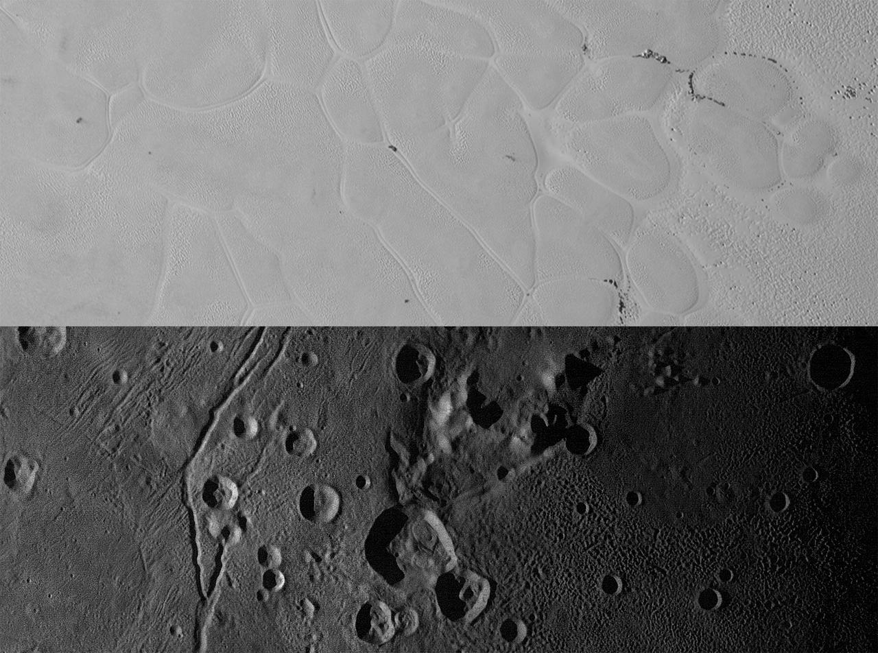
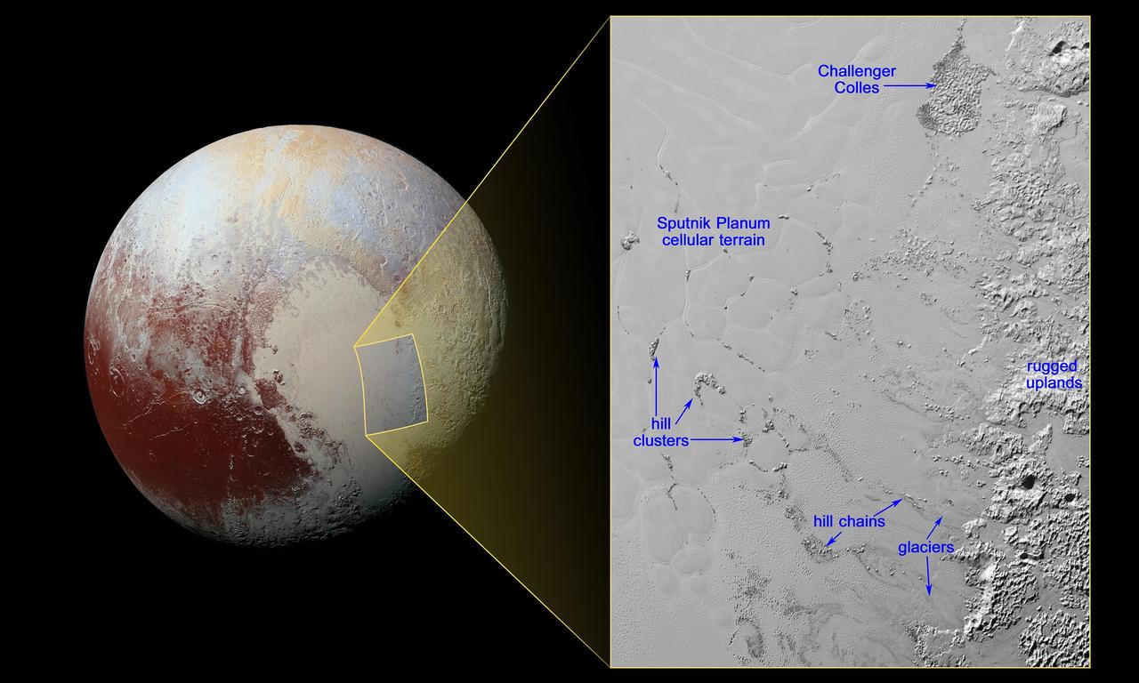
New Horizons views of the informally named Sputnik Planum on Pluto (top) and the informally named Vulcan Planum on Charon (bottom). Both scale bars measure 20 miles (32 kilometers) long; illumination is from the left in both instances. The Sputnik Planum view is centered at 11°N, 180°E, and covers the bright, icy, geologically cellular plains. Here, the cells are defined by a network of interconnected troughs that crisscross these nitrogen-ice plains. At right, in the upper image, the cellular plains yield to pitted plains of southern Sputnik Planum. This observation was obtained by the Ralph/Multispectral Visible Imaging Camera (MVIC) at a resolution of 1,050 feet (320 meters) per pixel. The Vulcan Planum view in the bottom panel is centered at 4°S, 4°E, and includes the "moated mountain" Clarke Mons just above the center of the image. As well as featuring impact craters and sinuous troughs, the water ice-rich plains display a range of surface textures, from smooth and grooved at left, to pitted and hummocky at right. This observation was obtained by the Long Range Reconnaissance Imager (LORRI) at a resolution of 525 feet (160 meters) per pixel. http://photojournal.jpl.nasa.gov/catalog/PIA20535
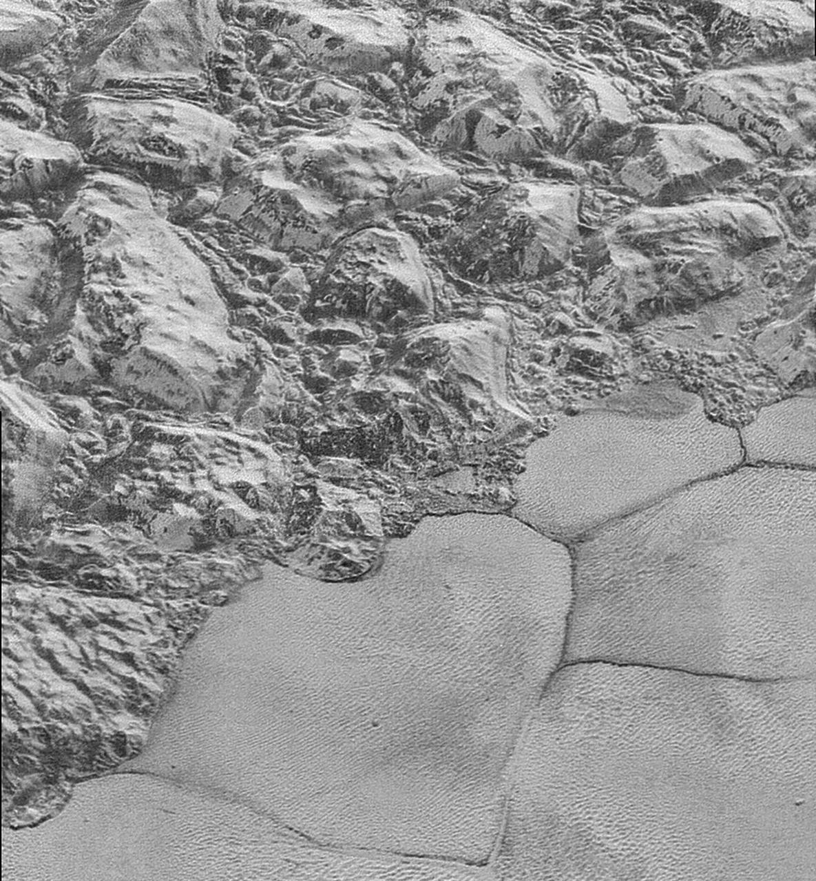
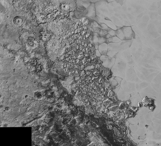
In this highest-resolution image from NASA's New Horizons spacecraft, great blocks of Pluto's water-ice crust appear jammed together in the informally named al-Idrisi mountains. Some mountain sides appear coated in dark material, while other sides are bright. Several sheer faces appear to show crustal layering, perhaps related to the layers seen in some of Pluto's crater walls. Other materials appear crushed between the mountains, as if these great blocks of water ice, some standing as much as 1.5 miles high, were jostled back and forth. The mountains end abruptly at the shoreline of the informally named Sputnik Planum, where the soft, nitrogen-rich ices of the plain form a nearly level surface, broken only by the fine trace work of striking, cellular boundaries and the textured surface of the plain's ices (which is possibly related to sunlight-driven ice sublimation). This view is about 50 miles wide. The top of the image is to Pluto's northwest. These images were made with the telescopic Long Range Reconnaissance Imager (LORRI) aboard New Horizons, in a timespan of about a minute centered on 11:36 UT on July 14 -- just about 15 minutes before New Horizons' closest approach to Pluto -- from a range of just 10,000 miles (17,000 kilometers). They were obtained with an unusual observing mode; instead of working in the usual "point and shoot," LORRI snapped pictures every three seconds while the Ralph/Multispectral Visual Imaging Camera (MVIC) aboard New Horizons was scanning the surface. This mode requires unusually short exposures to avoid blurring the images. http://photojournal.jpl.nasa.gov/catalog/PIA20198
Ice (probably frozen nitrogen) that appears to have accumulated on the uplands on the right side of this 390-mile (630-kilometer) wide image is draining from Pluto's mountains onto the informally named Sputnik Planum through the 2- to 5-mile (3- to 8- kilometer) wide valleys. The flow front of the ice moving into Sputnik Planum is outlined by the blue arrows. The origin of the ridges and pits on the right side of the image remains uncertain. http://photojournal.jpl.nasa.gov/catalog/PIA19944
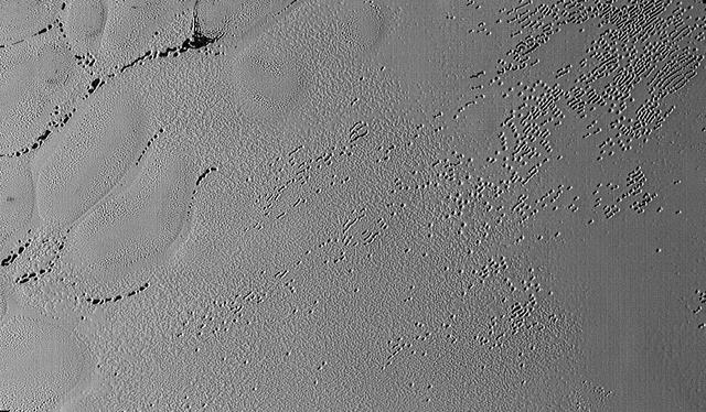
NASA New Horizons cameras have spied swarms of mysterious pits across the informally named Sputnik Planum. Scientists believe the pits may form through a combination of sublimation and ice fracturing. http://photojournal.jpl.nasa.gov/catalog/PIA20151
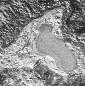
NASA New Horizons spacecraft captured this feature which appears to be a frozen, former lake of liquid nitrogen, located in a mountain range just north of Pluto informally named Sputnik Planum.
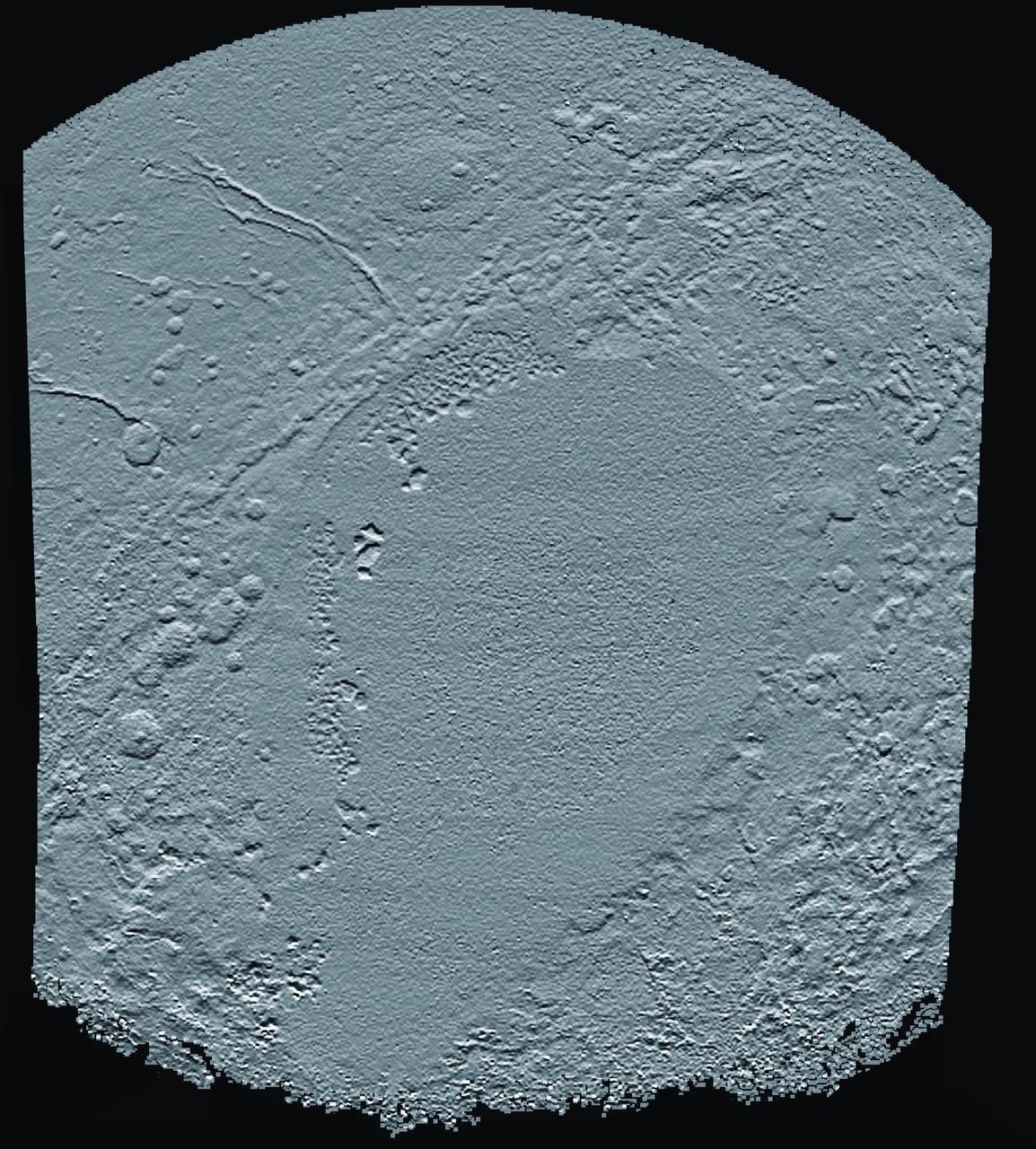
This shaded relief view from NASA New Horizons of the region surrounding the left side of Pluto heart-shaped feature, informally named Sputnik Planum, shows that the vast expanse of its icy surface.

This geological map from NASA New Horizons covers a portion of Pluto surface and includes the vast nitrogen-ice plain informally named Sputnik Planum and surrounding terrain.

NASA New Horizons scientists believe that the informally named feature Wright Mons, located south of Sputnik Planum on Pluto, and another, Piccard Mons, could have been formed by the cryovolcanic eruption of ices from beneath Pluto surface. Sputnik Planum on Pluto, is an unusual feature that's about 100 miles (160 kilometers) wide and 13,000 feet (4 kilometers) high. It displays a summit depression (visible in the center of the image) that's approximately 35 miles (56 kilometers) across, with a distinctive hummocky texture on its sides. The rim of the summit depression also shows concentric fracturing. http://photojournal.jpl.nasa.gov/catalog/PIA20155

Mosaic of high-resolution images of Pluto, sent back from NASA's New Horizons spacecraft from Sept. 5 to 7, 2015. The image is dominated by the informally-named icy plain Sputnik Planum, the smooth, bright region across the center. This image also features a tremendous variety of other landscapes surrounding Sputnik. The smallest visible features are 0.5 miles (0.8 kilometers) in size, and the mosaic covers a region roughly 1,000 miles (1600 kilometers) wide. The image was taken as New Horizons flew past Pluto on July 14, 2015, from a distance of 50,000 miles (80,000 kilometers). http://photojournal.jpl.nasa.gov/catalog/PIA19936
In the center of this 300-mile (470-kilometer) wide image of Pluto from NASA's New Horizons spacecraft is a large region of jumbled, broken terrain on the northwestern edge of the vast, icy plain informally called Sputnik Planum, to the right. The smallest visible features are 0.5 miles (0.8 kilometers) in size. This image was taken as New Horizons flew past Pluto on July 14, 2015, from a distance of 50,000 miles (80,000 kilometers). http://photojournal.jpl.nasa.gov/catalog/PIA19934

Mosaic of high-resolution images of Pluto, transmitted by NASA's New Horizons spacecraft from Sept. 5 to 7, 2015. The image is dominated by the informally-named icy plain Sputnik Planum, the smooth, bright region across the center. This image also features a tremendous variety of other landscapes surrounding Sputnik. The smallest visible features are 0.5 miles (0.8 kilometers) in size, and the mosaic covers a region roughly 1,000 miles (1,600 kilometers) wide. The image was taken as New Horizons flew past Pluto on July 14, 2015, from a distance of 50,000 miles (80,000 kilometers). The two white rectangles show the locations of the two closeup views by New Horizons, released separately. http://photojournal.jpl.nasa.gov/catalog/PIA19935
Images of Pluto taken by NASA New Horizons spacecraft before closest approach on July 14, 2015, reveal features as small as 270 yards (250 meters) across, from craters to faulted mountain blocks, to the textured surface of the vast basin informally called Sputnik Planum. Enhanced color has been added from the global color image. This image is about 330 miles (530 kilometers) across. http://photojournal.jpl.nasa.gov/catalog/PIA19955

The backlighting highlights the intricate flow lines on the glaciers. The flow front of the ice is moving into the informally named Sputnik Planum. The origin of the ridges and pits on the right side of the image remains uncertain. This image is 390 miles (630 kilometers) across. http://photojournal.jpl.nasa.gov/catalog/PIA19943
This enhanced color mosaic combines some of the sharpest views of Pluto that NASA's New Horizons spacecraft obtained during its July 14 flyby. The pictures are part of a sequence taken near New Horizons' closest approach to Pluto, with resolutions of about 250-280 feet (77-85 meters) per pixel -- revealing features smaller than half a city block on Pluto's surface. Lower resolution color data (at about 2,066 feet, or 630 meters, per pixel) were added to create this new image. The images form a strip 50 miles (80 kilometers) wide, trending (top to bottom) from the edge of "badlands" northwest of the informally named Sputnik Planum, across the al-Idrisi mountains, onto the shoreline of Pluto's "heart" feature, and just into its icy plains. They combine pictures from the telescopic Long Range Reconnaissance Imager (LORRI) taken approximately 15 minutes before New Horizons' closest approach to Pluto, with -- from a range of only 10,000 miles (17,000 kilometers) -- with color data (in near-infrared, red and blue) gathered by the Ralph/Multispectral Visible Imaging Camera (MVIC) 25 minutes before the LORRI pictures. The wide variety of cratered, mountainous and glacial terrains seen here gives scientists and the public alike a breathtaking, super-high-resolution color window into Pluto's geology. e border between the relatively smooth Sputnik Planum ice sheet and the pitted area, with a series of hills forming slightly inside this unusual "shoreline." http://photojournal.jpl.nasa.gov/catalog/PIA20213
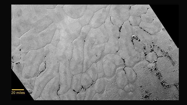
At center left of Pluto vast heart-shaped feature "Tombaugh Regio" -- lies a vast, craterless plain that appears to be no more than 100 million years old, and is possibly still being shaped by geologic processes as seen by NASA New Horizons spacecraft. This frozen region is north of Pluto's icy mountains and has been informally named Sputnik Planum (Sputnik Plain), after Earth's first artificial satellite. The surface appears to be divided into irregularly-shaped segments that are ringed by narrow troughs. Features that appear to be groups of mounds and fields of small pits are also visible. This image was acquired by the Long Range Reconnaissance Imager (LORRI) on July 14 from a distance of 48,000 miles (77,000 kilometers). Features as small as one-half mile (1 kilometer) across are visible. The blocky appearance of some features is due to compression of the image. http://photojournal.jpl.nasa.gov/catalog/PIA19841

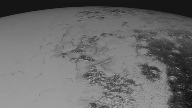
Just 15 minutes after its closest approach to Pluto on July 14, 2015, NASA's New Horizons spacecraft looked back toward the sun and captured this near-sunset view of the rugged, icy mountains and flat ice plains extending to Pluto's horizon. The smooth expanse of the informally named icy plain Sputnik Planum (right) is flanked to the west (left) by rugged mountains up to 11,000 feet (3,500 meters) high, including the informally named Norgay Montes in the foreground and Hillary Montes on the skyline. To the right, east of Sputnik, rougher terrain is cut by apparent glaciers. The backlighting highlights more than a dozen layers of haze in Pluto's tenuous but distended atmosphere. The image was taken from a distance of 11,000 miles (18,000 kilometers) to Pluto; the scene is 780 miles (1,250 kilometers) wide. http://photojournal.jpl.nasa.gov/catalog/PIA19948
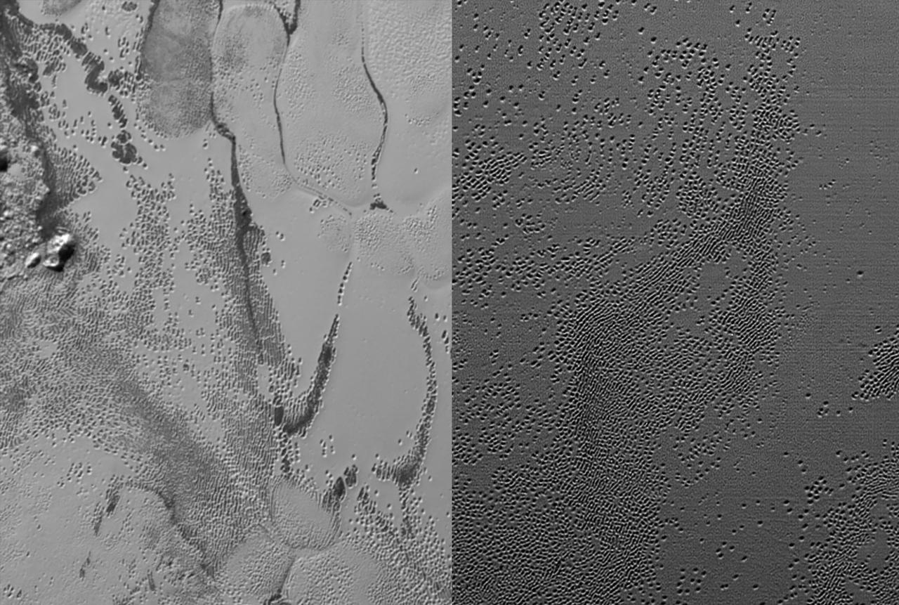
NASA's New Horizons spacecraft continues to transmit the sharpest views of Pluto that it obtained (and recorded) during its flyby of the distant planet on July 14, 2015. The newest image, returned on Dec. 24, 2015, extends New Horizons' highest-resolution swath of Pluto to the very center of the informally named Sputnik Planum, and nearly completes the set of highest-resolution images taken by New Horizons last July. The pictures are part of a sequence taken near New Horizons' closest approach to Pluto, with resolutions of about 250-280 feet (77-85 meters) per pixel -- revealing features smaller than half a city block on Pluto's surface. The images shown here form a strip 50 miles (80 kilometers) wide and more than 400 miles (700 kilometers) long, trending from the northwestern shoreline of Sputnik Planum and out across its icy plains. The images illustrate the polygonal or cellular pattern of the plains, which are thought to result from the convective churning of a deep layer solid, but mobile, nitrogen ice. The surface of Sputnik Planum appears darker toward the shore (at top), possibly implying a change in composition or surface texture. The occasional raised, darker blocks at the cell edges are probably dirty water "icebergs" floating in denser solid nitrogen. The pictures were taken with the telescopic Long Range Reconnaissance Imager (LORRI) aboard New Horizons, from a range of approximately 10,000 miles (17,000 kilometers) over a timespan of about a minute centered on 11:36 UT on July 14 -- just about 15 minutes before New Horizons' closest approach to Pluto. http://photojournal.jpl.nasa.gov/catalog/PIA20336

This enhanced color view of Pluto's surface diversity was created by merging Ralph/Multispectral Visible Imaging Camera (MVIC) color imagery (650 meters per pixel) with Long Range Reconnaissance Imager panchromatic imagery (230 meters per pixel). At lower right, ancient, heavily cratered terrain is coated with dark, reddish tholins. At upper right, volatile ices filling the informally named Sputnik Planum have modified the surface, creating a chaos-like array of blocky mountains. Volatile ice also occupies a few nearby deep craters, and in some areas the volatile ice is pocked with arrays of small sublimation pits. At left, and across the bottom of the scene, gray-white CH4 ice deposits modify tectonic ridges, the rims of craters, and north-facing slopes. The scene in this image is 260 miles (420 kilometers) wide and 140 miles (225 kilometers) from top to bottom; north is to the upper left. http://photojournal.jpl.nasa.gov/catalog/PIA20534

This synthetic perspective view of Pluto, based on the latest high-resolution images to be downlinked from NASA's New Horizons spacecraft, shows what you would see if you were approximately 1,100 miles (1,800 kilometers) above Pluto's equatorial area, looking northeast over the dark, cratered, informally named Cthulhu Regio toward the bright, smooth, expanse of icy plains informally called Sputnik Planum. The entire expanse of terrain seen in this image is 1,100 miles (1,800 kilometers) across. The images were taken as New Horizons flew past Pluto on July 14, 2015, from a distance of 50,000 miles (80,000 kilometers). http://photojournal.jpl.nasa.gov/catalog/PIA19937

Just 15 minutes after its closest approach to Pluto on July 14, 2015, NASA's New Horizons spacecraft looked back toward the sun and captured a near-sunset view of the rugged, icy mountains and flat ice plains extending to Pluto's horizon. The smooth expanse of the informally named Sputnik Planum (right) is flanked to the west (left) by rugged mountains up to 11,000 feet (3,500 meters) high, including the informally named Norgay Montes in the foreground and Hillary Montes on the skyline. The backlighting highlights more than a dozen layers of haze in Pluto's tenuous but distended atmosphere. The image was taken from a distance of 11,000 miles (18,000 kilometers) to Pluto; the scene is 230 miles (380 kilometers) across. http://photojournal.jpl.nasa.gov/catalog/PIA19947

This high-resolution swat of Pluto sweeps over the cratered plains at the west of the New Horizons' encounter hemisphere and across numerous prominent faults, skimming the eastern margin of the dark, forbidding region informally known as Cthulhu Regio, and finally passing over the mysterious, possibly cryovolcanic edifice Wright Mons, before reaching the terminator or day-night line. Among the many notable details shown are the overlapping and infilling relationships between units of the relatively smooth, bright volatile ices from Sputnik Planum (at the edge of the mosaic) and the dark edge or "shore" of Cthulhu. The pictures in this mosaic were taken by the Long Range Reconnaissance Imager (LORRI) in "ride-along" mode with the LEISA spectrometer, which accounts for the 'zigzag' or step pattern. Taken shortly before New Horizons' July 14 closest approach to Pluto, details as small as 500 yards (500 meters) can be seen. http://photojournal.jpl.nasa.gov/catalog/PIA20286

Like a cosmic lava lamp, a large section of Pluto's icy surface is being constantly renewed by a process called convection that replaces older surface ices with fresher material. Scientists from NASA's New Horizons mission used state-of-the-art computer simulations to show that the surface of Pluto's informally named Sputnik Planum is covered with churning ice "cells" that are geologically young and turning over due to a process called convection. The scene above, which is about 250 miles (400 kilometers) across, uses data from the New Horizons Ralph/Multispectral Visible Imaging Camera (MVIC), gathered July 14, 2015. Their findings are published in the June 2, 2016, issue of the journal Nature. http://photojournal.jpl.nasa.gov/catalog/PIA20726
This mosaic is composed of the sharpest views of Pluto that NASA's New Horizons spacecraft obtained during its flyby of the distant planet on July 14, 2015. The pictures are part of a sequence taken near New Horizons' closest approach to Pluto, with resolutions of about 250-280 feet (77-85 meters) per pixel -- revealing features smaller than half a city block on Pluto's diverse surface. The images include a wide variety of spectacular, cratered, mountainous and glacial terrains -- giving scientists and the public alike a breathtaking, super-high resolution window on Pluto's geology. The images form a strip 50 miles (80 kilometers) wide trending from Pluto's jagged horizon about 500 miles (800 kilometers) northwest of the informally named Sputnik Planum, across the al-Idrisi mountains, onto the shoreline of Sputnik Planum and then across its icy plains. They were made with the telescopic Long Range Reconnaissance Imager (LORRI) aboard New Horizons, over a timespan of about a minute centered on 11:36 UT on July 14 -- just about 15 minutes before New Horizons' closest approach to Pluto -- from a range of just 10,000 miles (17,000 kilometers). They were obtained with an unusual observing mode; instead of working in the usual "point and shoot," LORRI snapped pictures every three seconds while the Ralph/Multispectral Visual Imaging Camera (MVIC) aboard New Horizons was scanning the surface. This mode requires unusually short exposures to avoid blurring the images. http://photojournal.jpl.nasa.gov/catalog/PIA20201

This frame from a movie is composed of the sharpest views of Pluto that NASA's New Horizons spacecraft obtained during its flyby of the distant planet on July 14, 2015. The pictures are part of a sequence taken near New Horizons' closest approach to Pluto, with resolutions of about 250-280 feet (77-85 meters) per pixel -- revealing features smaller than half a city block on Pluto's diverse surface. The images include a wide variety of spectacular, cratered, mountainous and glacial terrains -- giving scientists and the public alike a breathtaking, super-high resolution window on Pluto's geology. The images form a strip 50 miles (80 kilometers) wide trending from Pluto's jagged horizon about 500 miles (800 kilometers) northwest of the informally named Sputnik Planum, across the al-Idrisi mountains, onto the shoreline of Sputnik Planum and then across its icy plains. They were made with the telescopic Long Range Reconnaissance Imager (LORRI) aboard New Horizons, over a timespan of about a minute centered on 11:36 UT on July 14 -- just about 15 minutes before New Horizons' closest approach to Pluto -- from a range of just 10,000 miles (17,000 kilometers). They were obtained with an unusual observing mode; instead of working in the usual "point and shoot," LORRI snapped pictures every three seconds while the Ralph/Multispectral Visual Imaging Camera (MVIC) aboard New Horizons was scanning the surface. This mode requires unusually short exposures to avoid blurring the images. http://photojournal.jpl.nasa.gov/catalog/PIA20202
On July 14, 2015, the telescopic camera on NASA's New Horizons spacecraft took the highest resolution images ever obtained of the intricate pattern of "pits" across a section of Pluto's prominent heart-shaped region, informally named Tombaugh Regio. Mission scientists believe these mysterious indentations may form through a combination of ice fracturing and evaporation. The scarcity of overlying impact craters in this area also leads scientists to conclude that these pits -- typically hundreds of yards across and tens of yards deep -- formed relatively recently. Their alignment provides clues about the ice flow and the exchange of nitrogen and other volatile materials between the surface and the atmosphere. The image is part of a sequence taken by New Horizons' Long Range Reconnaissance Imager (LORRI) as the spacecraft passed within 9,550 miles (15,400 kilometers) of Pluto's surface, just 13 minutes before the time of closest approach. The small box on the global view shows the section of the region imaged in the southeast corner of the giant ice sheet informally named Sputnik Planum. The magnified view is 50-by-50 miles (80-by-80 kilometers) across. The large ring-like structure near the bottom right of the magnified view -- and the smaller one near the bottom left -- may be remnant craters. The upper-left quadrant of the image shows the border between the relatively smooth Sputnik Planum ice sheet and the pitted area, with a series of hills forming slightly inside this unusual "shoreline." http://photojournal.jpl.nasa.gov/catalog/PIA20212
This image was taken by the Long Range Reconnaissance Imager (LORRI) on NASA's New Horizons spacecraft shortly before closest approach to Pluto on July 14, 2015; it resolves details as small as 270 yards (250 meters). The scene shown is about 130 miles (210 kilometers) across. The sun illuminates the scene from the left, and north is to the upper left. Credits: NASA/JHUAPL/SwRI It seems that the more we see of Pluto, the more fascinating it gets. With its prominent heart-shaped feature, icy mountains, and “snakeskin” terrain, Pluto has already surprised New Horizons scientists with the variety and complexity of its surface features. Now this latest image, from the heart of Pluto’s heart feature, show the plains’ enigmatic cellular pattern (at left) as well as unusual clusters of small pits and troughs (from lower left to upper right). Scientists believe that this area, informally known as Sputnik Planum, is composed of volatile ices such as solid nitrogen. They theorize that the pits and troughs – typically hundreds of meters across and tens of meters deep – are possibly formed by sublimation or evaporation of these ices. However, the reasons for the striking shapes and alignments of these features are a mystery. Adding to the intrigue is that even at this resolution, no impact craters are seen, testifying to the extreme geologic youth of Sputnik Planum. “Pluto is weird, in a good way,” said Hal Weaver, New Horizons project scientist with Johns Hopkins Applied Physics Laboratory in Laurel, Maryland. “The pits, and the way they’re aligned, provide clues about the ice flow and the exchange of volatiles between the surface and atmosphere, and the science team is working hard to understand what physical processes are at play here.” <b><a href="http://www.nasa.gov/audience/formedia/features/MP_Photo_Guidelines.html" rel="nofollow">NASA image use policy.</a></b> <b><a href="http://www.nasa.gov/centers/goddard/home/index.html" rel="nofollow">NASA Goddard Space Flight Center</a></b> enables NASA’s mission through four scientific endeavors: Earth Science, Heliophysics, Solar System Exploration, and Astrophysics. Goddard plays a leading role in NASA’s accomplishments by contributing compelling scientific knowledge to advance the Agency’s mission. <b>Follow us on <a href="http://twitter.com/NASAGoddardPix" rel="nofollow">Twitter</a></b> <b>Like us on <a href="http://www.facebook.com/pages/Greenbelt-MD/NASA-Goddard/395013845897?ref=tsd" rel="nofollow">Facebook</a></b> <b>Find us on <a href="http://instagrid.me/nasagoddard/?vm=grid" rel="nofollow">Instagram</a></b>

This enhanced color view from NASA's New Horizons spacecraft zooms in on the southeastern portion of Pluto's great ice plains, where at lower right the plains border rugged, dark highlands informally named Krun Macula. Krun Macula -- Krun is the lord of the underworld in the Mandaean religion, and a macula is a dark feature on a planetary surface -- is believed to get its dark red color from tholins, complex molecules found across Pluto. Krun Macula rises 1.5 miles (2.5 kilometers) above the surrounding plain -- informally named Sputnik Planum -- and is scarred by clusters of connected, roughly circular pits that typically reach between 5 and 8 miles (8 and 13 kilometers) across, and up to 1.5 miles (2.5 kilometers) deep. At the boundary with Sputnik Planum, these pits form deep valleys reaching more than 25 miles (40 kilometers) long, 12.5 miles (20 kilometers) wide and almost 2 miles (3 kilometers) deep (almost twice as deep as the Grand Canyon in Arizona), and have floors covered with nitrogen ice. New Horizons scientists think these pits may have formed through surface collapse, although what may have prompted such a collapse is a mystery. This scene was created using three separate observations made by New Horizons in July 2015. The right half of the image is composed of 260 feet- (80 meter-) per-pixel data from the Long Range Reconnaissance Imager (LORRI), obtained at 9,850 miles (15,850 kilometers) from Pluto, about 23 minutes before New Horizons' closest approach. The left half is composed of 410 feet- (125 meter-) per-pixel LORRI data, obtained about six minutes earlier, with New Horizons 15,470 miles (24,900 kilometers) from Pluto. These data respectively represent portions of the highest- and second-highest-resolution observations obtained by New Horizons in the Pluto system. The entire scene was then colorized using 2230 feet- (680 meter-) per-pixel data from New Horizons' Ralph/Multispectral Visual Imaging Camera (MVIC), obtained at 21,100 miles (33,900 kilometers) from Pluto, about 45 minutes before closest approach. http://photojournal.jpl.nasa.gov/catalog/PIA20732
This enhanced color view from NASA's New Horizons spacecraft zooms in on the southeastern portion of Pluto's great ice plains, where at lower right the plains border rugged, dark highlands informally named Krun Macula. Krun Macula -- Krun is the lord of the underworld in the Mandaean religion, and a macula is a dark feature on a planetary surface -- is believed to get its dark red color from tholins, complex molecules found across Pluto. Krun Macula rises 1.5 miles (2.5 kilometers) above the surrounding plain -- informally named Sputnik Planum -- and is scarred by clusters of connected, roughly circular pits that typically reach between 5 and 8 miles (8 and 13 kilometers) across, and up to 1.5 miles (2.5 kilometers) deep. At the boundary with Sputnik Planum, these pits form deep valleys reaching more than 25 miles (40 kilometers) long, 12.5 miles (20 kilometers) wide and almost 2 miles (3 kilometers) deep (almost twice as deep as the Grand Canyon in Arizona), and have floors covered with nitrogen ice. New Horizons scientists think these pits may have formed through surface collapse, although what may have prompted such a collapse is a mystery. This scene was created using three separate observations made by New Horizons in July 2015. The right half of the image is composed of 260 feet- (80 meter-) per-pixel data from the Long Range Reconnaissance Imager (LORRI), obtained at 9,850 miles (15,850 kilometers) from Pluto, about 23 minutes before New Horizons' closest approach. The left half is composed of 410 feet- (125 meter-) per-pixel LORRI data, obtained about six minutes earlier, with New Horizons 15,470 miles (24,900 kilometers) from Pluto. These data respectively represent portions of the highest- and second-highest-resolution observations obtained by New Horizons in the Pluto system. The entire scene was then colorized using 2230 feet- (680 meter-) per-pixel data from New Horizons' Ralph/Multispectral Visual Imaging Camera (MVIC), obtained at 21,100 miles (33,900 kilometers) from Pluto, about 45 minutes before closest approach. http://photojournal.jpl.nasa.gov/catalog/PIA20733

In September, NASA's New Horizons team released a stunning but incomplete image of Pluto's crescent. Thanks to new processing work by the science team, New Horizons is releasing the entire, breathtaking image of Pluto. This image was made just 15 minutes after New Horizons' closest approach to Pluto on July 14, 2015, as the spacecraft looked back at Pluto toward the sun. The wide-angle perspective of this view shows the deep haze layers of Pluto's atmosphere extending all the way around Pluto, revealing the silhouetted profiles of rugged plateaus on the night (left) side. The shadow of Pluto cast on its atmospheric hazes can also be seen at the uppermost part of the disk. On the sunlit side of Pluto (right), the smooth expanse of the informally named icy plain Sputnik Planum is flanked to the west (above, in this orientation) by rugged mountains up to 11,000 feet (3,500 meters) high, including the informally named Norgay Montes in the foreground and Hillary Montes on the skyline. Below (east) of Sputnik, rougher terrain is cut by apparent glaciers. The backlighting highlights more than a dozen high-altitude layers of haze in Pluto's tenuous atmosphere. The horizontal streaks in the sky beyond Pluto are stars, smeared out by the motion of the camera as it tracked Pluto. The image was taken with New Horizons' Multi-spectral Visible Imaging Camera (MVIC) from a distance of 11,000 miles (18,000 kilometers) to Pluto. The resolution is 700 meters (0.4 miles).

Pluto has long been a mystery, a dot at our solar system’s margins. The best images, even with NASA’s Hubble Space Telescope, were fuzzy and pixelated. In July 2015, NASA’s New Horizons spacecraft flew past Pluto and captured the sharpest views of the dwarf planet to date. One of the most striking areas, informally named "Sputnik Planum," is a sweeping, frozen plain the size of Texas and ringed by mountains of ice. Its smooth deposits are unmarred by impact craters, a stark contrast to the rest of Pluto’s battered surface. As a result, scientists believe the region formed recently, within the last few hundred million years. This contradicts past depictions of Pluto as an unchanging world. By analyzing images taken during the flyby, scientists hope to unravel more of the dwarf planet’s history. Watch the video for an up-close look at Pluto. Credit: NASA's Goddard Space Flight Center Video courtesy of NASA/Johns Hopkins University Applied Physics Laboratory/Southwest Research Institute/S. Robbins
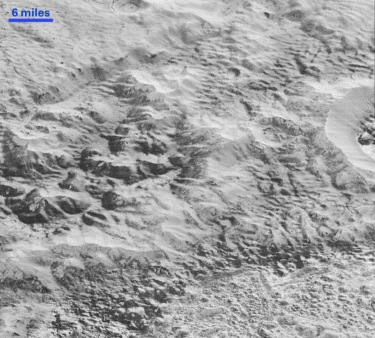
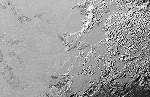
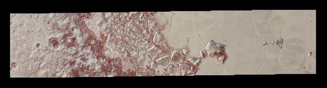
This highest-resolution image from NASA's New Horizons spacecraft shows how erosion and faulting has sculpted this portion of Pluto's icy crust into rugged badlands. The prominent 1.2-mile-high cliff at the top, running from left to upper right, is part of a great canyon system that stretches for hundreds of miles across Pluto's northern hemisphere. New Horizons team members think that the mountains in the middle are made of water ice, but have been modified by the movement of nitrogen or other exotic ice glaciers over long periods of time, resulting in a muted landscape of rounded peaks and intervening sets of short ridges. At the bottom of this 50-mile-wide image, the terrain transforms dramatically into a fractured and finely broken up floor at the northwest margin of the giant ice plain informally called Sputnik Planum. The top of the image is to Pluto's northwest. These images were made with the telescopic Long Range Reconnaissance Imager (LORRI) aboard New Horizons, in a timespan of about a minute centered on 11:36 UT on July 14 -- just about 15 minutes before New Horizons' closest approach to Pluto -- from a range of just 10,000 miles (17,000 kilometers). They were obtained with an unusual observing mode; instead of working in the usual "point and shoot," LORRI snapped pictures every three seconds while the Ralph/Multispectral Visual Imaging Camera (MVIC) aboard New Horizons was scanning the surface. This mode requires unusually short exposures to avoid blurring the images. http://photojournal.jpl.nasa.gov/catalog/PIA20199

This synthetic perspective view of Pluto, based on the latest high-resolution images to be downlinked from NASA’s New Horizons spacecraft, shows what you would see if you were approximately 1,100 miles (1,800 kilometers) above Pluto’s equatorial area, looking northeast over the dark, cratered, informally named Cthulhu Regio toward the bright, smooth, expanse of icy plains informally called Sputnik Planum. The entire expanse of terrain seen in this image is 1,100 miles (1,800 kilometers) across. The images were taken as New Horizons flew past Pluto on July 14, 2015, from a distance of 50,000 miles (80,000 kilometers). Read more: <a href="http://1.usa.gov/1MgG7io" rel="nofollow">1.usa.gov/1MgG7io</a> Credit: NASA/Johns Hopkins University Applied Physics Laboratory/Southwest Research Institute <b><a href="http://www.nasa.gov/audience/formedia/features/MP_Photo_Guidelines.html" rel="nofollow">NASA image use policy.</a></b> <b><a href="http://www.nasa.gov/centers/goddard/home/index.html" rel="nofollow">NASA Goddard Space Flight Center</a></b> enables NASA’s mission through four scientific endeavors: Earth Science, Heliophysics, Solar System Exploration, and Astrophysics. Goddard plays a leading role in NASA’s accomplishments by contributing compelling scientific knowledge to advance the Agency’s mission. <b>Follow us on <a href="http://twitter.com/NASAGoddardPix" rel="nofollow">Twitter</a></b> <b>Like us on <a href="http://www.facebook.com/pages/Greenbelt-MD/NASA-Goddard/395013845897?ref=tsd" rel="nofollow">Facebook</a></b> <b>Find us on <a href="http://instagrid.me/nasagoddard/?vm=grid" rel="nofollow">Instagram</a></b>

Imagine a future spacecraft following New Horizons' trailblazing path to Pluto, but instead of flying past its target -- as New Horizons needed to do to explore Pluto and the Kuiper Belt beyond -- the next visitor touches down near the tall mountains on the frozen icy, plains of Pluto's heart. A video produced by New Horizons scientists that offers that very perspective. Made from more than 100 New Horizons images taken over six weeks of approach and close flyby, the video offers a trip in to Pluto -- starting with a distant spacecraft's-eye view of Pluto and its largest moon, Charon, to an eventual ride in for a "landing" on the shoreline of Pluto's informally named Sputnik Planum. The video shows what it would be like to ride aboard an approaching spacecraft and see Pluto grow from a "dot" to become a world, and then to swoop down over Pluto's spectacular terrains. New Horizons scientists had to interpolate some of the frames in the movie based on what they know Pluto looks like to make it as smooth and seamless as possible. After a 9.5-year voyage covering more than three billion miles, New Horizons flew through the Pluto system on July 14, 2015, coming within 7,800 miles (12,500 kilometers) of Pluto itself. Carrying powerful telescopic cameras that could spot features smaller than a football field, New Horizons has sent back hundreds of images of Pluto and its moons that show how dynamic and fascinating their surfaces are - and what great targets they'd make for follow-up mission one day. http://photojournal.jpl.nasa.gov/catalog/PIA20742
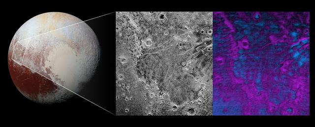
Scientists on NASA's New Horizons mission have discovered what looks like a giant bite-mark on the planet's surface. In this image, north is up. The southern portion of the left inset above shows the cratered plateau uplands informally named Vega Terra (note that all feature names are informal). This terrain is separated from the young, nearly uncratered, mottled plains of Piri Planitia in the center of the image by a generally north-facing jagged scarp called Piri Rupes. The scarp breaks up into isolated mesas in several places. Cutting diagonally across Piri Planitia is the long extensional fault of Inanna Fossa, which stretches eastward 370 miles (600 kilometers) from here to the western edge of the great nitrogen ice plains of Sputnik Planum. Compositional data from the New Horizons spacecraft's Ralph/Linear Etalon Imaging Spectral Array (LEISA) instrument, shown in the right inset, indicate that the plateau uplands south of Piri Rupes are rich in methane ice (shown in false color as purple). Scientists speculate that sublimation of methane may be causing the plateau material to erode along the face of the scarp cliffs, causing them to retreat south and leave the plains of Piri Planitia in their wake. Compositional data also show that the surface of Piri Planitia is more enriched in water ice (shown in false color as blue) than the plateau uplands, which may indicate that Piri Planitia's surface is made of water ice bedrock, on top of which the layer of retreating methane ice had been sitting. Because the surface of Pluto is so cold, the water ice behaves like rock and is immobile. The light/dark mottled pattern of Piri Planitia in the left inset is reflected in the composition map, with the lighter areas corresponding to areas richer in methane – these may be remnants of methane that have not yet sublimated away entirely. The inset at left shows about 650 feet (200 meters) per pixel; the image measures approximately 280 miles (450 kilometers) long by 255 miles (410 kilometers) wide. It was obtained by New Horizons at a range of approximately 21,100 miles (33,900 kilometers) from Pluto, about 45 minutes before the spacecraft's closest approach to Pluto on July 14, 2015.The LEISA data at right was gathered when the spacecraft was about 29,000 miles (47,000 kilometers) from Pluto; best resolution is 1.7 miles (2.7 kilometers) per pixel. http://photojournal.jpl.nasa.gov/catalog/PIA20531

NASA's New Horizons spacecraft took this stunning image of Pluto only a few minutes after closest approach on July 14, 2015. The image was obtained at a high phase angle -- that is, with the sun on the other side of Pluto, as viewed by New Horizons. Seen here, sunlight filters through and illuminates Pluto's complex atmospheric haze layers. The southern portions of the nitrogen ice plains informally named Sputnik Planum, as well as mountains of the informally named Norgay Montes, can also be seen across Pluto's crescent at the top of the image. Looking back at Pluto with images like this gives New Horizons scientists information about Pluto's hazes and surface properties that they can't get from images taken on approach. The image was obtained by New Horizons' Ralph/Multispectral Visual Imaging Camera (MVIC) approximately 13,400 miles (21,550 kilometers) from Pluto, about 19 minutes after New Horizons' closest approach. The image has a resolution of 1,400 feet (430 meters) per pixel. Pluto's diameter is 1,475 miles (2,374 kilometers). The inset at top right in the annotated version shows a detail of Pluto's crescent, including an intriguing bright wisp (near the center) measuring tens of miles across that may be a discreet, low-lying cloud in Pluto's atmosphere; if so, it would be the only one yet identified in New Horizons imagery. This cloud -- if that's what it is -- is visible for the same reason the haze layers are so bright: illumination from the sunlight grazing Pluto's surface at a low angle. Atmospheric models suggest that methane clouds can occasionally form in Pluto's atmosphere. The scene in this inset is 140 miles (230 kilometers) across. The inset at bottom right shows more detail on the night side of Pluto. This terrain can be seen because it is illuminated from behind by hazes that silhouette the of the annotated version limb. The topography here appears quite rugged, and broad valleys and sharp peaks with relief totaling 3 miles (5 kilometers) are apparent. This image, made from closer range, is much better than the lower-resolution images of this same terrain taken several days before closest approach. These silhouetted terrains therefore act as a useful "anchor point," giving New Horizons scientists a rare, detailed glimpse at the lay of the land in this mysterious part of Pluto seen at high resolution only in twilight. The scene in this inset is 460 miles (750 kilometers) wide. http://photojournal.jpl.nasa.gov/catalog/PIA20727