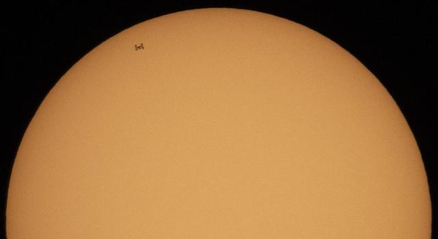
The International Space Station, with a crew of three onboard, is seen in silhouette as it transits the Sun at roughly five miles per second, Sunday, Oct. 7, 2018 from Suffolk, Va. Onboard are Expedition 57 Commander Alexander Gerst of ESA (European Space Agency), Serena Auñón-Chancellor of NASA, and Sergey Prokopyev of Roscosmos. The trio will soon be joined by Nick Hague of NASA and Alexey Ovchinin of Roscosmos, who are scheduled to launch on October 11 from the Baikonur Cosmodrome in Kazakhstan. Photo Credit: (NASA/Joel Kowsky)
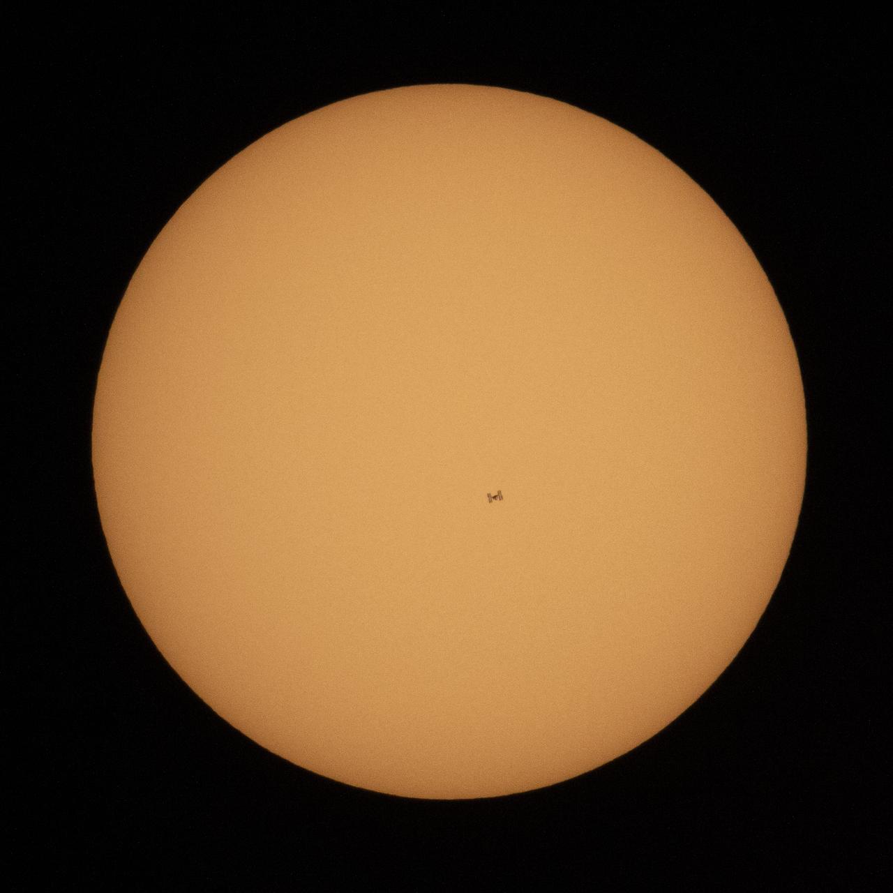
The International Space Station, with a crew of three onboard, is seen in silhouette as it transits the Sun at roughly five miles per second, Sunday, Oct. 7, 2018 from Suffolk, Va. Onboard are Expedition 57 Commander Alexander Gerst of ESA (European Space Agency), Serena Auñón-Chancellor of NASA, and Sergey Prokopyev of Roscosmos. The trio will soon be joined by Nick Hague of NASA and Alexey Ovchinin of Roscosmos, who are scheduled to launch on October 11 from the Baikonur Cosmodrome in Kazakhstan. Photo Credit: (NASA/Joel Kowsky)
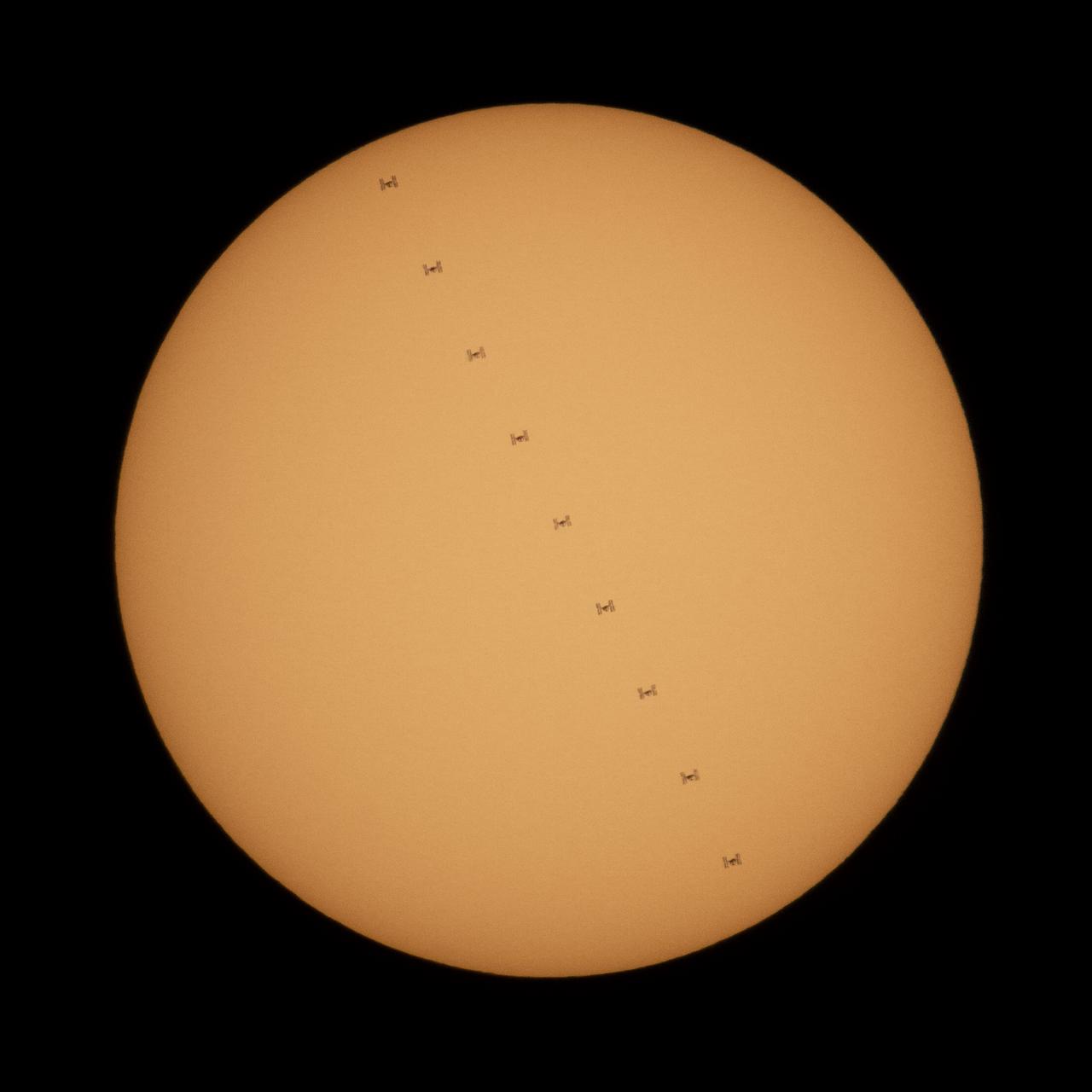
This composite image, made from nine frames, shows the International Space Station, with a crew of three onboard, in silhouette as it transits the Sun at roughly five miles per second, Sunday, Oct. 7, 2018 from Suffolk, Va. Onboard are Expedition 57 Commander Alexander Gerst of ESA (European Space Agency), Serena Auñón-Chancellor of NASA, and Sergey Prokopyev of Roscosmos. The trio will soon be joined by Nick Hague of NASA and Alexey Ovchinin of Roscosmos, who are scheduled to launch on October 11 from the Baikonur Cosmodrome in Kazakhstan. Photo Credit: (NASA/Joel Kowsky)
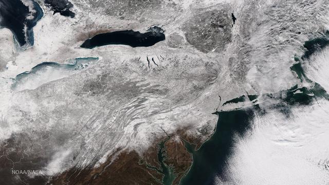
As the storm moves offshore and the skies clear over the Northeast United States, the extent of snowfall from the blizzard is shown in this image from the Suomi NPP satellite imagery, taken on January 28, 2015 at 1:50 EST. Portions of Suffolk County, New York and parts of eastern and southern New England, including areas in and around Portland, Maine, Boston, Massachusetts, and Providence, Rhode Island, received more than 20 inches of snowfall. Up to 36 inches of snow were reported in Auburn, Hudson and Lunenburg, Massachusetts. Credit: NASA/NOAA/NPP/VIIRS Via: <b><a href="www.nnvl.noaa.gov/" rel="nofollow"> NOAA Environmental Visualization Laboratory</a></b> <b><a href="http://www.nasa.gov/audience/formedia/features/MP_Photo_Guidelines.html" rel="nofollow">NASA image use policy.</a></b> <b><a href="http://www.nasa.gov/centers/goddard/home/index.html" rel="nofollow">NASA Goddard Space Flight Center</a></b> enables NASA’s mission through four scientific endeavors: Earth Science, Heliophysics, Solar System Exploration, and Astrophysics. Goddard plays a leading role in NASA’s accomplishments by contributing compelling scientific knowledge to advance the Agency’s mission. <b>Follow us on <a href="http://twitter.com/NASAGoddardPix" rel="nofollow">Twitter</a></b> <b>Like us on <a href="http://www.facebook.com/pages/Greenbelt-MD/NASA-Goddard/395013845897?ref=tsd" rel="nofollow">Facebook</a></b> <b>Find us on <a href="http://instagram.com/nasagoddard?vm=grid" rel="nofollow">Instagram</a></b>
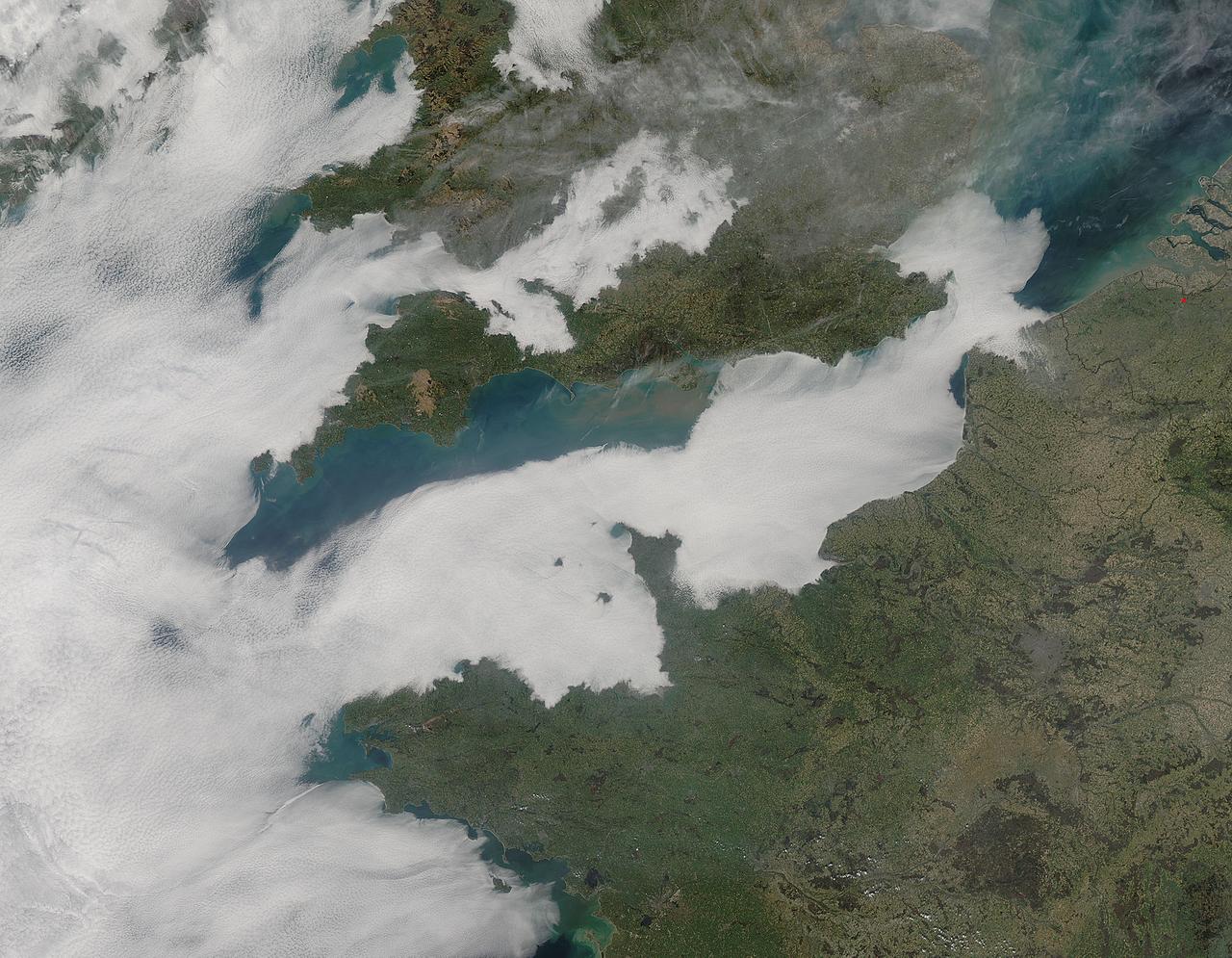
A thick blanket of low clouds covered the English Channel, Celtic Sea and Irish Sea on March 13, 2014. The fog also crept over major cities in the United Kingdom and Ireland. While citizens living in parts of Ireland, England, Wales, Scotland and Northern Ireland were posting ground-based photos of fog-shrouded landscape on social media, the internet and news outlets, the scene was also captured from space. The Moderate Resolution Imaging Spectroradiometer (MODIS) aboard NASA’s Aqua captured this true-color image of the cloudy day at 13:00 UTC (1:00 p.m. in London) on that same day. The dense fog (low clouds) affected air travel, causing the cancellation of hundreds of flights going through London City Airport, where visibility was reported at less than 100 meters (328 ft) – less than the length of an American football field. Flights were also cancelled at Heathrow, Gatwick and Manchester. A private helicopter flying to Northern Ireland went down in by the fog near the Norfolk-Suffolk border, with loss of four lives. Driving was little better in many areas, causing the Met Office to issue a yellow weather warning and to caution drivers of difficult conditions. The lowest visibility of the day was reported at Roches Point weather station. Located at the southeastern tip of Cork Harbor, Ireland, the station reported visibility of less than 50 meters (164 ft) – the length of an Olympic size swimming pool. In this image, the fog-covered Celtic Sea is located in the southwest. Ireland lies under tendrils of low cloud in the northwest corner of the image. Banks of clouds part around England, near the center of the image, and southern Wales (top and center) completely under the foggy blanket. Fog also creeps over the coasts of France, Belgium and the Netherlands on the east side of the English Channel. Credit: NASA/GSFC/Jeff Schmaltz/MODIS Land Rapid Response Team <b><a href="http://www.nasa.gov/audience/formedia/features/MP_Photo_Guidelines.html" rel="nofollow">NASA image use policy.</a></b> <b><a href="http://www.nasa.gov/centers/goddard/home/index.html" rel="nofollow">NASA Goddard Space Flight Center</a></b> enables NASA’s mission through four scientific endeavors: Earth Science, Heliophysics, Solar System Exploration, and Astrophysics. Goddard plays a leading role in NASA’s accomplishments by contributing compelling scientific knowledge to advance the Agency’s mission. <b>Follow us on <a href="http://twitter.com/NASAGoddardPix" rel="nofollow">Twitter</a></b> <b>Like us on <a href="http://www.facebook.com/pages/Greenbelt-MD/NASA-Goddard/395013845897?ref=tsd" rel="nofollow">Facebook</a></b> <b>Find us on <a href="http://instagram.com/nasagoddard?vm=grid" rel="nofollow">Instagram</a></b>