
Image of Surveyor 1 shadow against the lunar surface in the late lunar afternoon, with the horizon at the upper right. Surveyor 1, the first of the Surveyor missions to make a successful soft landing, proved the spacecraft design and landing technique
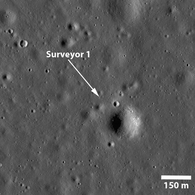
NASA Surveyor 1 spacecraft sitting silently on Oceanus Procellarum, the first US spacecraft to land on another planet on June 2, 1966 in this image taken by NASA Lunar Reconnaissance Orbiter.

A truck arrives at NASA's Jet Propulsion Laboratory in Southern California on June 3, 2024, to deliver the Medium Articulating Transportation System (MATS), which will be used during the construction and transportation of components for NASA's Near-Earth Object Surveyor mission. Originating at the aerospace company Beyond Gravity in Vienna, Austria, the MATS traveled via ship through the Panama Canal to Port Hueneme, California, before arriving by road at JPL. Construction has begun on NEO Surveyor's instrument enclosure in the High Bay 1 clean room at JPL's Spacecraft Assembly Facility. When the enclosure is complete later this year, it will be moved inside the MATS to NASA's Johnson Space Center in Houston for environmental testing. The MATS is a transportable clean room with its own filtration and climate control systems that keep the spacecraft and components clean, stable, and safe while being moved between facilities. NEO Surveyor's instrument enclosure contains the spacecraft's telescope, mirrors, and infrared sensors that will be used to detect, track, and characterize the most hazardous near-Earth objects. BAE Systems, Space Dynamics Laboratory, and Teledyne are among the aerospace and engineering companies contracted to build the spacecraft and its instrumentation. The Laboratory for Atmospheric and Space Physics at the University of Colorado, Boulder will support operations, and IPAC at Caltech in Pasadena, California, is responsible for processing survey data and producing the mission's data products. JPL manages the project; Caltech manages JPL for NASA. Launching no earlier than 2027, NEO Surveyor supports the objectives of NASA's Planetary Defense Coordination Office (PDCO) at NASA Headquarters in Washington. The NASA Authorization Act of 2005 directed NASA to discover and characterize at least 90% of the near-Earth objects more than 140 meters (460 feet) across that come within 30 million miles (48 million kilometers) of our planet's orbit. Objects of this size can cause significant regional damage, or worse, should they impact the Earth. https://photojournal.jpl.nasa.gov/catalog/PIA26381
This image of the vicinity of the Viking Lander 1 was captured by NASA Mars Global Surveyor MOC camera. site. 3D glasses are necessary to identify surface detail.
Somewhere down there sits the Mars Pathfinder lander and Sojourner rover. This Mars Global Surveyor Mars Orbiter Camera view of the red planet shows the region that includes Ares Vallis and the Chryse Plains upon which both Mars Pathfinder and the Viking 1 landed in 1997 and 1976, respectively. Acidalia Planitia is the dark surface that dominates the center left. The Pathfinder site is immediately south of Acidalia, just left of center in this view. Also shown--the north polar cap is at the top, and Arabia Terra and Sinus Meridiani are to the right. The bluish-white features are clouds. This is a color composite of 9 red and 9 blue image strips taken by the Mars Global Surveyor Mars Orbiter Camera on 9 successive orbits from pole-to-pole during the calibration phase of the mission in March 1999. The color is computer-enhanced and is not shown as it would actually appear to the human eye. http://photojournal.jpl.nasa.gov/catalog/PIA02000

jsc2024e067094 (1/14/2024) --- Kent State University’s co-principal investigators, Mackenzie Guy and Jonathan King from the College of Aeronautics and Engineering, develop their experiment in the Design Lab located in the Aeronautics and Engineering Building. Their experiment, The Effects of Microgravity on Pisum sativum Roots, is part of the Nanoracks-National Center for Earth and Space Science Education-Surveyor-Student Spaceflight Experiments Program Mission 18 to ISS (Nanoracks-NCESSE-Surveyor-SSEP).
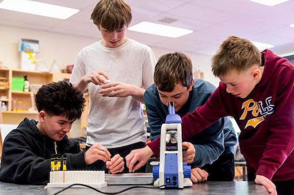
jsc2024e066523 (1/6/2024) --- Colorado Springs students Noah Grebe, Luke Davis, and Blake MacDonald observe crystal growth.Their experiment, Calcium Sulfate Crystal Growth in Microgravity, is part of the Nanoracks-National Center for Earth and Space Science Education-Surveyor-Student Spaceflight Experiments Program Mission 18 to ISS (Nanoracks-NCESSE-Surveyor-SSEP).
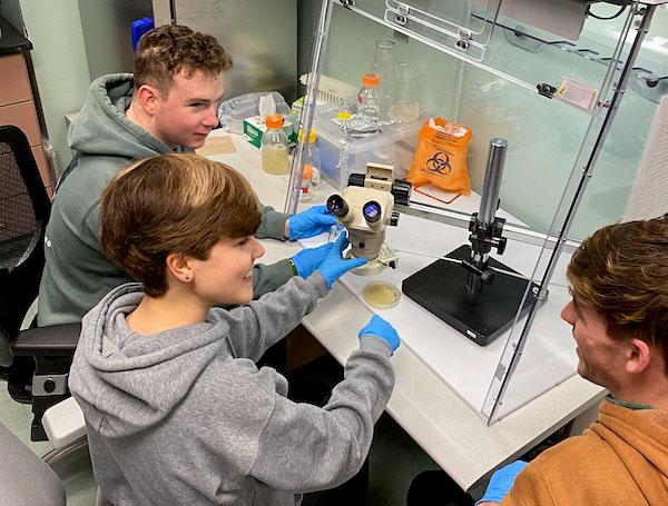
jsc2024e067093 (1/19/2024) --- Ohio University’s Mission 18 Team (Michael Lane, Victoria Swiler and Nathan Smith) examine the growth of Sphingomonas sanguinis, an ISS-derived bacteria. Their experiment, Effect of Spaceflight-Adapted Bacteria on Plant Growth and Resilience in Microgravity, is part of the Nanoracks-National Center for Earth and Space Science Education-Surveyor-Student Spaceflight Experiments Program Mission 18 to ISS (Nanoracks-NCESSE-Surveyor-SSEP).

jsc2024e067095 (1/30/2024) --- Pickerington High School North students Macy Erickson and Dorian Hamilton prepard Elodea samples and hydration solution for their research experiment trials. Their experiment, Effects of Microgravity on Liquid I.V. Hydration Multiplier, is part of the Nanoracks-National Center for Earth and Space Science Education-Surveyor-Student Spaceflight Experiments Program Mission 18 to ISS (Nanoracks-NCESSE-Surveyor-SSEP).

jsc2024e066520 (1/31/2024) --- Glendora High School students test ethanol concentrations to minimize diffusion loss. Their experiment, Cyanobacteria (Trichormus variabilis) Growth in Extreme Conditions of Microgravity, is part of the Nanoracks-National Center for Earth and Space Science Education-Surveyor-Student Spaceflight Experiments Program Mission 18 to ISS (Nanoracks-NCESSE-Surveyor-SSEP).
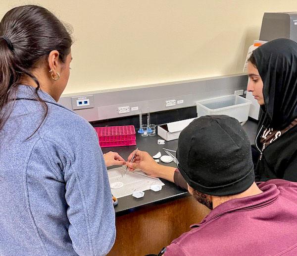
jsc2024e067100 (1/22/2024) --- The San Jacinto College – South Campus student team prepares a trial run to optimize germination conditions for their experiment, Comparison of Arabidopsis thaliana Germination and Cell Wall Growth in Microgravity versus Standard Conditions. Their experiment is part of the Nanoracks-National Center for Earth and Space Science Education-Surveyor-Student Spaceflight Experiments Program Mission 18 to ISS (Nanoracks-NCESSE-Surveyor-SSEP).

jsc2024e067105 (1/29/2024) --- Eddie Finley Junior High School student researchers (Caris Gray and Olivia Jones) adding tardigrade to the experiment tube to begin terrestrial examination of tardigrade growth. Their experiment, Tardigrade Growth in Space, is part of the Nanoracks-National Center for Earth and Space Science Education-Surveyor-Student Spaceflight Experiments Program Mission 18 to ISS (Nanoracks-NCESSE-Surveyor-SSEP).
jsc2024e066514 (1/19/2024) --- The flight team from Michael Strembitsky School conducts trials on Dugesia flatworms to examine their ability to regenerate and reproduce in microgravity. Their experiment, The Effect of Microgravity on Reproduction of Dugesia tigrina, is part of the Nanoracks-National Center for Earth and Space Science Education-Surveyor-Student Spaceflight Experiments Program Mission 18 to ISS (Nanoracks-NCESSE-Surveyor-SSEP).
jsc2024e066535 (1/31/2024) --- The University of North Dakota Space Beans Crew looks over their data during the first run of their experiment, The Effects of 6-Benzylaminopurine Enriched Soil on the Growth of Phaseolus vulgaris (Black Beans) in Microgravity. Their experiment is part of the Nanoracks-National Center for Earth and Space Science Education-Surveyor-Student Spaceflight Experiments Program Mission 18 to ISS (Nanoracks-NCESSE-Surveyor-SSEP).

jsc2024e066515 (2/1/2024) --- Alma Public School students remove the sample compostable bag from garden soil following a 10-day period to measure the bag to determine the extent of decomposition. Their experiment, Will Soil Bacteria Biodegrade Compostable Plastic in Microgravity?, is part of the Nanoracks-National Center for Earth and Space Science Education-Surveyor-Student Spaceflight Experiments Program Mission 18 to ISS (Nanoracks-NCESSE-Surveyor-SSEP).

jsc2024e066518 (11/1/2023) --- Mesa Publc School students work together presenting their critical design review to their industry partners Honeywell Aerospace Technologies in their successful bid to be a finalist for the Nanoracks-National Center for Earth and Space Science Education-Surveyor-Student Spaceflight Experiments Program Mission 18 to ISS (Nanoracks-NCESSE-Surveyor-SSEP). Their experiment is The Growth and Mutation of Staphylococcus epidermidis Biofilm in Microgravity.

At NASA's Jet Propulsion Laboratory in Southern California, on June 7, 2024, clean room technicians use a crane to lift the lid of the Medium Articulating Transportation System (MATS) that will be used during the construction and transportation of components for NASA's Near-Earth Object Surveyor mission. Inside the MATS is the Medium Articulating Assembly Dolly (MAAD), a platform that will support the spacecraft's instrument enclosure, which is being constructed inside the High Bay 1 clean room at JPL's Spacecraft Assembly Facility. The MAAD is an articulating platform on which a spacecraft (or spacecraft components) can be mounted securely and positioned as required during assembly. It can tilt a spacecraft vertically and horizontally, rotating it 360 degrees. JPL plans to use the MAAD for future missions to reduce the number of crane lifts during assembly, test, and launch operations, known as ATLO. NEO Surveyor is the first mission to use the platform. NEO Surveyor's instrument enclosure contains the spacecraft's telescope, mirrors, and infrared sensors that will be used to detect, track, and characterize the most hazardous near-Earth objects. BAE Systems, Space Dynamics Laboratory, and Teledyne are among the aerospace and engineering companies contracted to build the spacecraft and its instrumentation. The Laboratory for Atmospheric and Space Physics at the University of Colorado, Boulder will support operations, and IPAC at Caltech in Pasadena, California, is responsible for processing survey data and producing the mission's data products. JPL manages the project; Caltech manages JPL for NASA. Launching no earlier than 2027, NEO Surveyor supports the objectives of NASA's Planetary Defense Coordination Office (PDCO) at NASA Headquarters in Washington. The NASA Authorization Act of 2005 directed NASA to discover and characterize at least 90% of the near-Earth objects more than 140 meters (460 feet) across that come within 30 million miles (48 million kilometers) of our planet's orbit. Objects of this size can cause significant regional damage, or worse, should they impact the Earth. https://photojournal.jpl.nasa.gov/catalog/PIA26382
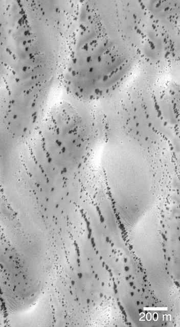
The patterns created by dark spots on defrosting south polar dunes are often strange and beautiful. This picture, which the Mars Orbiter Camera team has dubbed, "the snow leopard," shows a dune field located at 61.5°S, 18.9°W, as it appeared on July 1, 1999. The spots are areas where dark sand has been exposed from beneath bright frost as the south polar winter cap begins to retreat. Many of the spots have a diffuse, bright ring around them this is thought to be fresh frost that was re-precipitated after being removed from the dark spot. The spots seen on defrosting polar dunes are a new phenomenon that was not observed by previous spacecraft missions to Mars. Thus, there is much about these features that remains unknown. For example, no one yet knows why the dunes become defrosted by forming small spots that grow and grow over time. No one knows for sure if the bright rings around the dark spots are actually composed of re-precipitated frost. And no one knows for sure why some dune show spots that appear to be "lined-up" (as they do in the picture shown here). This Mars Global Surveyor Mars Orbiter Camera image is illuminated from the upper left. North is toward the upper right. The scale bar indicates a distance of 200 meters (656 feet). http://photojournal.jpl.nasa.gov/catalog/PIA02301
Small light colored area within the crater is Surveyor 1 on lunar surface photographed by Lunar Orbiter III. Published in the book "A Century at Langley" by Joseph Chambers. pg. 93 Moon Lunar Orbiter-Lunar Orbiter III: The hidden or dark side of the Moon was taken by Lunar Orbiter III During its mission to photograph potential lunar-landing sites for Apollo missions. -- Photograph published in Winds of Change, 75th Anniversary NASA publication (page 94), by James Schultz. Photo Number:67-H-328 is 1967-L-04026
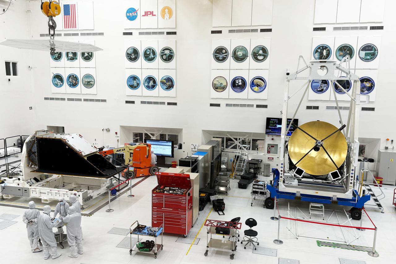
The dark, bulky instrument enclosure for NASA's NEO Surveyor is seen here (left) in the High Bay 1 clean room of the Spacecraft Assembly Facility at NASA's Jet Propulsion Laboratory in Southern California in March 2025. A major component of the mission, the instrument enclosure journeyed back to JPL in early March after completing environmental testing at NASA's Johnson Space Center in Houston. The gold-coated, circular antenna at right is part of the telescope for NASA's ASTHROS (Astrophysics Stratospheric Telescope for High Spectral Resolution Observations at Submillimeter-wavelengths), an atmospheric balloon mission; it has been in the clean room since December 2024. https://photojournal.jpl.nasa.gov/catalog/PIA26584

Astronaut Daniel W. Bursch, Expedition Four flight engineer, was delighted in capturing this image of Mt. Everest in the Himalayan Range from aboard the International Space Station (ISS). The mountain is near frame center. Because the photo was taken close to orbital sunrise, the low sun angle gave tremendous relief to the mountains. Named for Sir George Everest, the British surveyor-general of India, Mount Everest is the tallest point on earth. Standing 29,028 feet tall, it is 5 1/2 miles above sea level. Mount Everest is located half in Nepal and half in Tibet.
This picture is a composite of Mars Global Surveyor (MGS) Mars Orbiter Camera (MOC) daily global images acquired at Ls 211° during a previous Mars year. This month, Mars looks similar, as Ls 211° occurred in mid-May 2005. The picture shows the Elysium/Mare Cimmerium face of Mars. Over the course of the month, additional faces of Mars as it appears at this time of year are being posted for MOC Picture of the Day. Ls, solar longitude, is a measure of the time of year on Mars. Mars travels 360° around the Sun in 1 Mars year. The year begins at Ls 0°, the start of northern spring and southern autumn. http://photojournal.jpl.nasa.gov/catalog/PIA07988
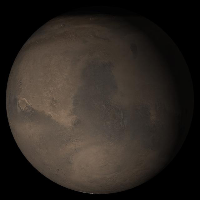
This picture, released 21 September 2005, is a composite of Mars Global Surveyor (MGS) Mars Orbiter Camera (MOC) daily global images acquired at Ls 288° during a previous Mars year. This month, Mars looks similar, as Ls 288° occurred in mid-September 2005. The picture shows the Syrtis Major face of Mars. Over the course of the month, additional faces of Mars as it appears at this time of year are being posted for MOC Picture of the Day. Ls, solar longitude, are a measure of the time of year on Mars. Mars travels 360° around the Sun in 1 Mars year. The year begins at Ls 0°, the start of northern spring and southern autumn.
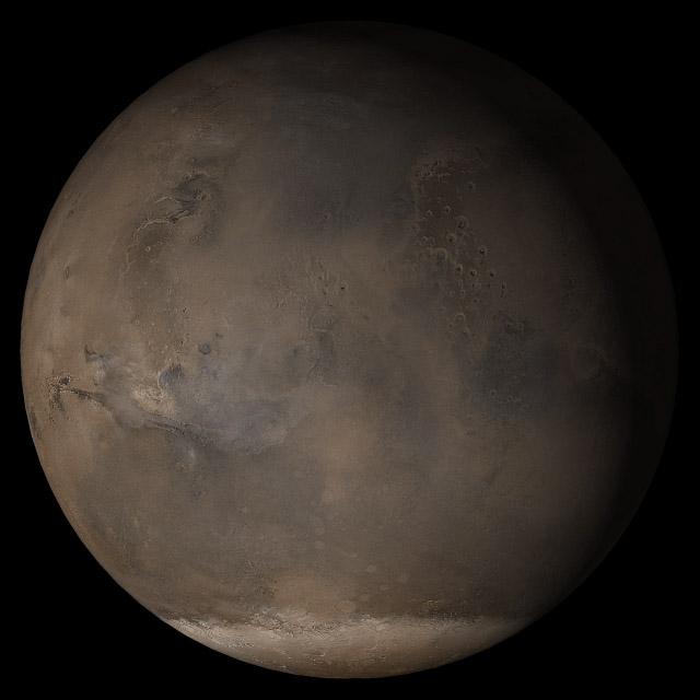
This picture is a composite of Mars Global Surveyor (MGS) Mars Orbiter Camera (MOC) daily global images acquired at Ls 176° during a previous Mars year. This month, Mars looks similar, as Ls 176° occurs in mid-March 2005. The picture shows the Acidalia/Mare Erythraeum face of Mars. Over the course of the month, additional faces of Mars as it appears at this time of year are being posted for MOC Picture of the Day. Ls, solar longitude, is a measure of the time of year on Mars. Mars travels 360° around the Sun in 1 Mars year. The year begins at Ls 0°, the start of northern spring and southern autumn. Season: Northern Summer/Southern Winter. http://photojournal.jpl.nasa.gov/catalog/PIA07443
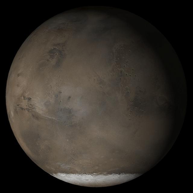
This picture is a composite of Mars Global Surveyor (MGS) Mars Orbiter Camera (MOC) daily global images acquired at Ls 193° during a previous Mars year. This month, Mars looks similar, as Ls 193° occurs in mid-April 2005. The picture shows the Acidalia/Mare Erythraeum face of Mars. Over the course of the month, additional faces of Mars as it appears at this time of year are being posted for MOC Picture of the Day. Ls, solar longitude, is a measure of the time of year on Mars. Mars travels 360° around the Sun in 1 Mars year. The year begins at Ls 0°, the start of northern spring and southern autumn. Location near: 47.3°N, 294.0°W Image width: ~3 km (~1.9 mi) Illumination from: lower left Season: Northern Summer. http://photojournal.jpl.nasa.gov/catalog/PIA07837
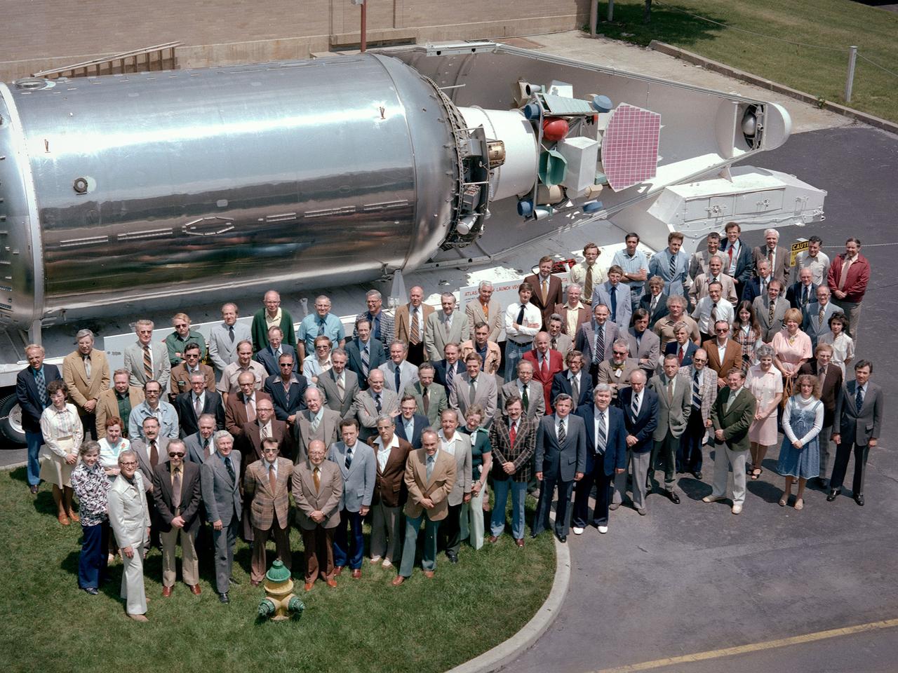
The National Aeronautics and Space Administration (NASA) Lewis Research Center’s Launch Vehicle Directorate in front of a full-scale model of the Centaur second-stage rocket. The photograph was taken to mark Centaur’s fiftieth launch. NASA Lewis managed the Centaur Program since 1962. At that time, the only prior launch attempt ended in failure. Lewis improved the spacecraft and tested it extensively throughout the early 1960s. In May 1966 an Atlas-Centaur sent the Surveyor spacecraft to the moon. It was the first successful soft landing on another planet. The Launch Vehicles Division was formed in 1969 to handle the increasing number of Centaur launches. The Lewis team became experts at integrating the payload with the Centaur and calculating proper trajectories for the missions. Centaur’s first 50 missions included Orbiting Astronomical Observatories, the Mariner 6 and 7 flybys of Mars, Mariner 9 which was the first spacecraft to orbit around another planet, the Pioneer 10 and 11 missions to the outer solar system, the Mariner 10 flyby of Venus and Mercury, the Viking 1 and 2 Mars landers, Voyagers 1 and 2 missions to Jupiter, Saturn, Uranus, and Neptune, and the Pioneer 12 and 13 flights to Venus.
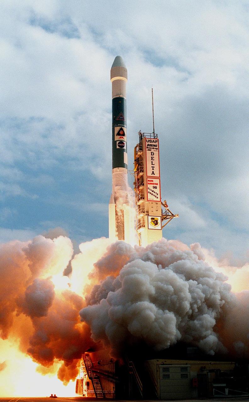
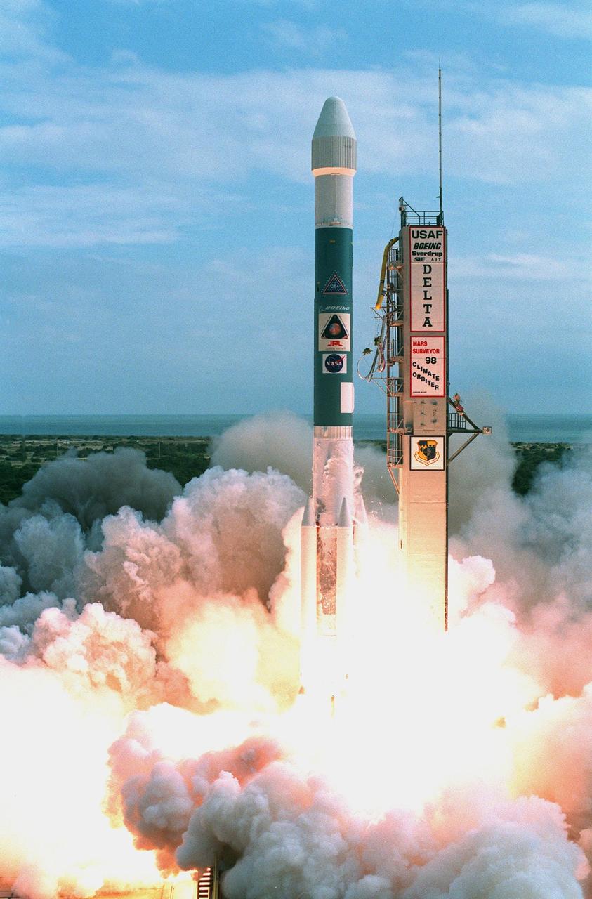
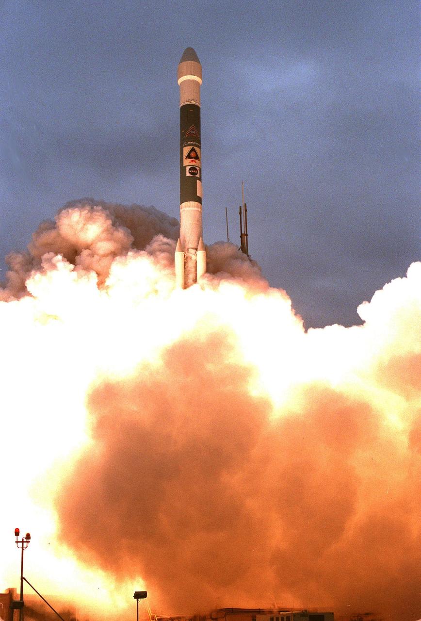
KENNEDY SPACE CENTER, FLA. -- A Boeing Delta II expendable launch vehicle lifts off with NASA's Mars Climate Orbiter at 1:45:51 p.m. EST, on Dec. 11, 1998, from Launch Complex 17A, Cape Canaveral Air Station. The launch was delayed one day when personnel detected a battery-related software problem in the spacecraft. The problem was corrected and the launch was rescheduled for the next day. The first of a pair of spacecraft to be launched in the Mars Surveyor '98 Project, the orbiter is heading for Mars where it will first provide support to its companion Mars Polar Lander spacecraft, which is planned for launch on Jan. 3, 1999. The orbiter's instruments will then monitor the Martian atmosphere and image the planet's surface on a daily basis for one Martian year (1.8 Earth years). It will observe the appearance and movement of atmospheric dust and water vapor, as well as characterize seasonal changes on the surface. The detailed images of the surface features will provide important clues to the planet's early climate history and give scientists more information about possible liquid water reserves beneath the surface
Valleys younger than better-known ancient valley networks on Mars are evident on the landscape in the northern Arabia Terra region of Mars, particularly in the area mapped here with color-coded topographical information overlaid onto a photo mosaic. The area includes a basin informally named "Heart Lake" at upper left (northwest). Data from the Mars Orbiter Laser Altimeter (MOLA) on NASA's Mars Global Surveyor orbiter are coded here as white and purple for lower elevations, yellow for higher elevation. The elevation information is combined with a mosaic of images from the Thermal Emission Imaging System (THEMIS) camera on NASA's Mars Odyssey orbiter, covering an area about 120 miles (about 190 kilometers) wide. The mapped area is centered near 35.91 degrees north latitude, 1 degree east longitude on Mars. These lakes and streams held water several hundred million years after better-known ancient lake environments on Mars, according to 2016 findings. http://photojournal.jpl.nasa.gov/catalog/PIA20838
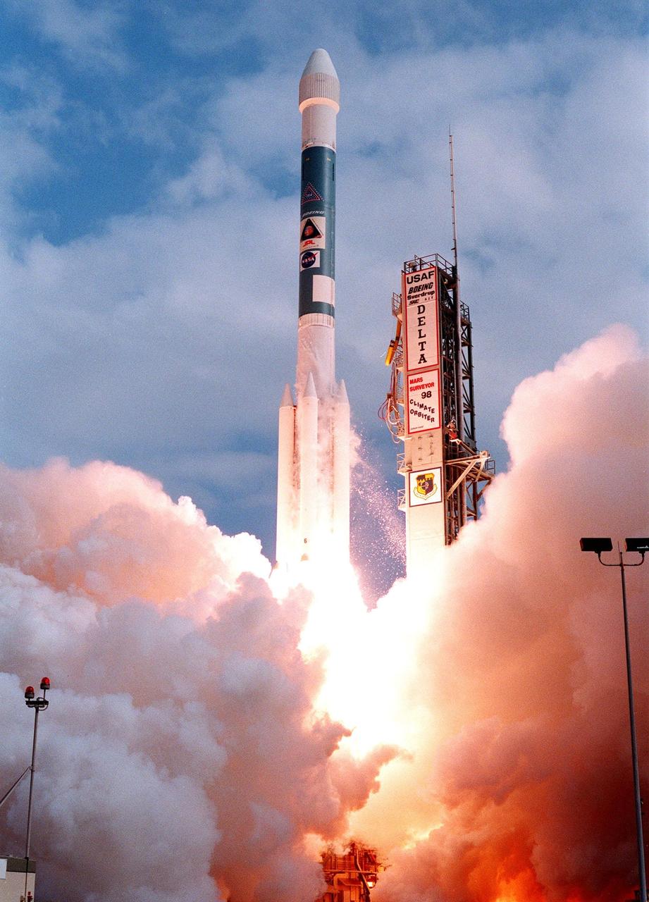
KENNEDY SPACE CENTER, FLA. -- A Boeing Delta II expendable launch vehicle lifts off with NASA's Mars Climate Orbiter at 1:45:51 p.m. EST, on Dec. 11, 1998, from Launch Complex 17A, Cape Canaveral Air Station. The launch was delayed one day when personnel detected a battery-related software problem in the spacecraft. The problem was corrected and the launch was rescheduled for the next day. The first of a pair of spacecraft to be launched in the Mars Surveyor '98 Project, the orbiter is heading for Mars where it will first provide support to its companion Mars Polar Lander spacecraft, which is planned for launch on Jan. 3, 1999. The orbiter's instruments will then monitor the Martian atmosphere and image the planet's surface on a daily basis for one Martian year (1.8 Earth years). It will observe the appearance and movement of atmospheric dust and water vapor, as well as characterize seasonal changes on the surface. The detailed images of the surface features will provide important clues to the planet's early climate history and give scientists more information about possible liquid water reserves beneath the surface
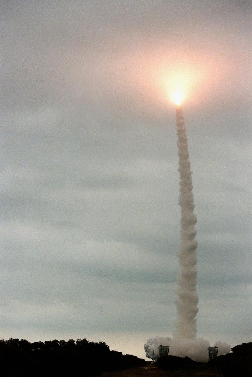
KENNEDY SPACE CENTER, FLA. -- Looking like a Roman candle, the exhaust from the Boeing Delta II rocket with the Mars Polar Lander aboard lights up the clouds as it hurtles skyward. The rocket was launched at 3:21:10 p.m. EST from Launch Complex 17B, Cape Canaveral Air Station. The lander is a solar-powered spacecraft designed to touch down on the Martian surface near the northern-most boundary of the south polar cap, which consists of carbon dioxide ice. The lander will study the polar water cycle, frosts, water vapor, condensates and dust in the Martian atmosphere. It is equipped with a robotic arm to dig beneath the layered terrain. In addition, Deep Space 2 microprobes, developed by NASA's New Millennium Program, are installed on the lander's cruise stage. After crashing into the planet's surface, they will conduct two days of soil and water experiments up to 1 meter (3 feet) below the Martian surface, testing new technologies for future planetary descent probes. The lander is the second spacecraft to be launched in a pair of Mars Surveyor '98 missions. The first is the Mars Climate Orbiter, which was launched aboard a Delta II rocket from Launch Complex 17A on Dec. 11, 1998.

A Boeing Delta II expendable launch vehicle lifts off with NASA's Mars Climate Orbiter at 1:45:51 p.m. EST, on Dec. 11, 1998, from Launch Complex 17A, Cape Canaveral Air Station. The launch was delayed one day when personnel detected a battery-related software problem in the spacecraft. The problem was corrected and the launch was rescheduled for the next day. The first of a pair of spacecraft to be launched in the Mars Surveyor '98 Project, the orbiter is heading for Mars where it will first provide support to its companion Mars Polar Lander spacecraft, which is planned for launch on Jan. 3, 1999. The orbiter's instruments will then monitor the Martian atmosphere and image the planet's surface on a daily basis for one Martian year (1.8 Earth years). It will observe the appearance and movement of atmospheric dust and water vapor, as well as characterize seasonal changes on the surface. The detailed images of the surface features will provide important clues to the planet's early climate history and give scientists more information about possible liquid water reserves beneath the surface
KENNEDY SPACE CENTER, FLA. -- A Boeing Delta II expendable launch vehicle lifts off with NASA's Mars Climate Orbiter at 1:45:51 p.m. EST, on Dec. 11, 1998, from Launch Complex 17A, Cape Canaveral Air Station. The launch was delayed one day when personnel detected a battery-related software problem in the spacecraft. The problem was corrected and the launch was rescheduled for the next day. The first of a pair of spacecraft to be launched in the Mars Surveyor '98 Project, the orbiter is heading for Mars where it will first provide support to its companion Mars Polar Lander spacecraft, which is planned for launch on Jan. 3, 1999. The orbiter's instruments will then monitor the Martian atmosphere and image the planet's surface on a daily basis for one Martian year (1.8 Earth years). It will observe the appearance and movement of atmospheric dust and water vapor, as well as characterize seasonal changes on the surface. The detailed images of the surface features will provide important clues to the planet's early climate history and give scientists more information about possible liquid water reserves beneath the surface
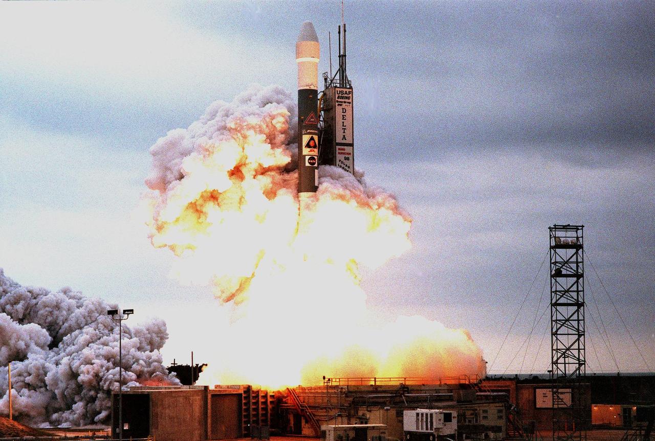
KENNEDY SPACE CENTER, FLA. -- Amid clouds of exhaust and into a gray-clouded sky , a Boeing Delta II expendable launch vehicle lifts off with NASA's Mars Polar Lander at 3:21:10 p.m. EST from Launch Complex 17B, Cape Canaveral Air Station. The lander is a solar-powered spacecraft designed to touch down on the Martian surface near the northern-most boundary of the south polar cap, which consists of carbon dioxide ice. The lander will study the polar water cycle, frosts, water vapor, condensates and dust in the Martian atmosphere. It is equipped with a robotic arm to dig beneath the layered terrain at the polar cap. In addition, Deep Space 2 microprobes, developed by NASA's New Millennium Program, are installed on the lander's cruise stage. After crashing into the planet's surface, they will conduct two days of soil and water experiments up to 1 meter (3 feet) below the Martian surface, testing new technologies for future planetary descent probes. The lander is the second spacecraft to be launched in a pair of Mars Surveyor '98 missions. The first is the Mars Climate Orbiter, which was launched aboard a Delta II rocket from Launch Complex 17A on Dec. 11, 1998.

KENNEDY SPACE CENTER, FLA. -- Silhouetted against the gray sky, a Boeing Delta II expendable launch vehicle with NASA's Mars Polar Lander lifts off from Launch Complex 17B, Cape Canaveral Air Station, at 3:21:10 p.m. EST. The lander is a solar-powered spacecraft designed to touch down on the Martian surface near the northern-most boundary of the south polar cap, which consists of carbon dioxide ice. The lander will study the polar water cycle, frosts, water vapor, condensates and dust in the Martian atmosphere. It is equipped with a robotic arm to dig beneath the layered terrain at the polar cap. In addition, Deep Space 2 microprobes, developed by NASA's New Millennium Program, are installed on the lander's cruise stage. After crashing into the planet's surface, they will conduct two days of soil and water experiments up to 1 meter (3 feet) below the Martian surface, testing new technologies for future planetary descent probes. The lander is the second spacecraft to be launched in a pair of Mars Surveyor '98 missions. The first is the Mars Climate Orbiter, which was launched aboard a Delta II rocket from Launch Complex 17A on Dec. 11, 1998.
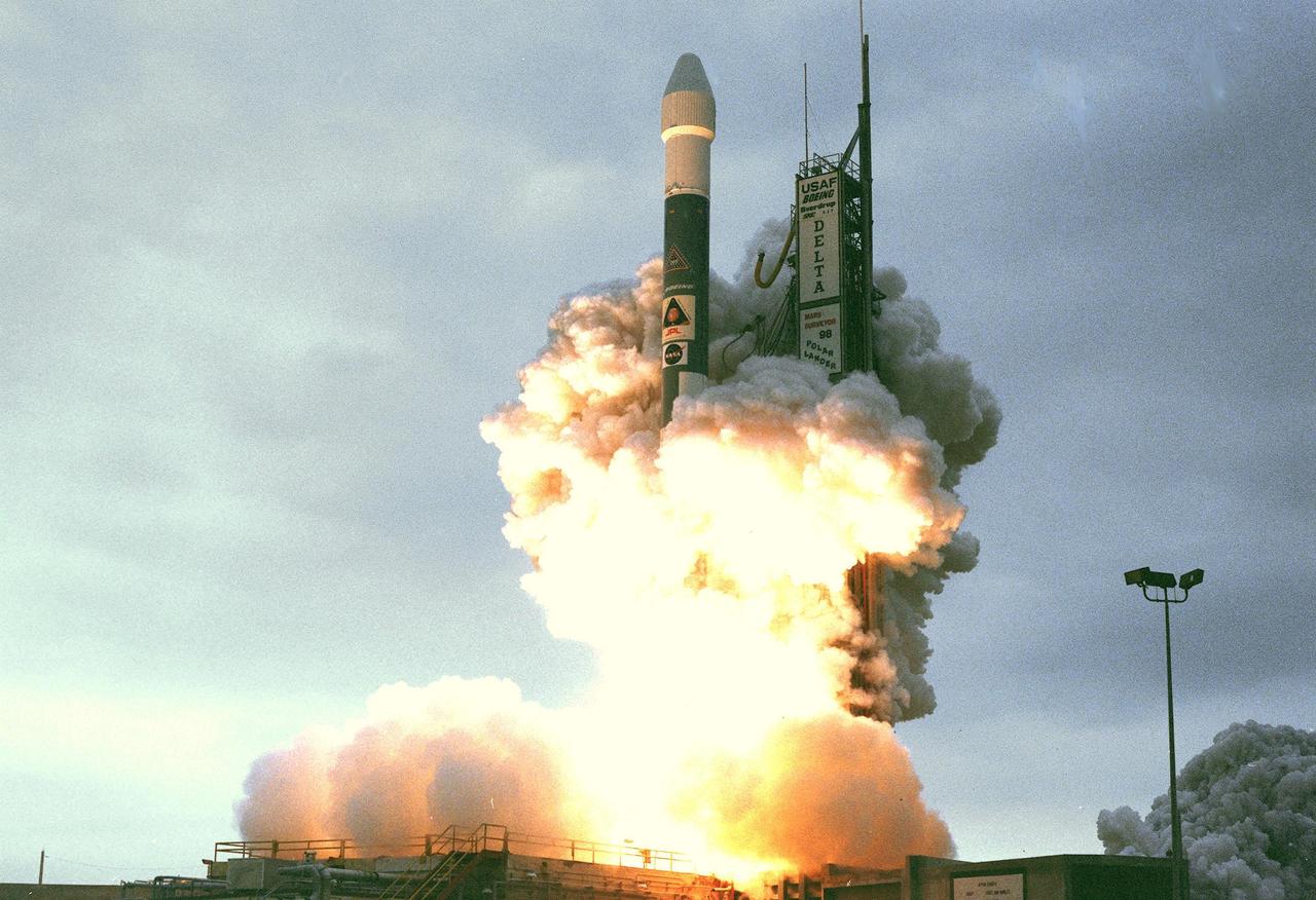
KENNEDY SPACE CENTER, FLA. -- Amid clouds of exhaust, a Boeing Delta II expendable launch vehicle with NASA's Mars Polar Lander clears Launch Complex 17B, Cape Canaveral Air Station, after launch at 3:21:10 p.m. EST. The lander is a solar-powered spacecraft designed to touch down on the Martian surface near the northern-most boundary of the south polar cap, which consists of carbon dioxide ice. The lander will study the polar water cycle, frosts, water vapor, condensates and dust in the Martian atmosphere. It is equipped with a robotic arm to dig beneath the layered terrain at the polar cap. In addition, Deep Space 2 microprobes, developed by NASA's New Millennium Program, are installed on the lander's cruise stage. After crashing into the planet's surface, they will conduct two days of soil and water experiments up to 1 meter (3 feet) below the Martian surface, testing new technologies for future planetary descent probes. The lander is the second spacecraft to be launched in a pair of Mars Surveyor '98 missions. The first is the Mars Climate Orbiter, which was launched aboard a Delta II rocket from Launch Complex 17A on Dec. 11, 1998.
KENNEDY SPACE CENTER, FLA. -- A Boeing Delta II expendable launch vehicle lifts off with NASA's Mars Polar Lander into a cloud-covered sky at 3:21:10 p.m. EST from Launch Complex 17B, Cape Canaveral Air Station. The lander is a solar-powered spacecraft designed to touch down on the Martian surface near the northern-most boundary of the south polar cap, which consists of carbon dioxide ice. The lander will study the polar water cycle, frosts, water vapor, condensates and dust in the Martian atmosphere. It is equipped with a robotic arm to dig beneath the layered terrain at the polar cap. In addition, Deep Space 2 microprobes, developed by NASA's New Millennium Program, are installed on the lander's cruise stage. After crashing into the planet's surface, they will conduct two days of soil and water experiments up to 1 meter (3 feet) below the Martian surface, testing new technologies for future planetary descent probes. The lander is the second spacecraft to be launched in a pair of Mars Surveyor '98 missions. The first is the Mars Climate Orbiter, which was launched aboard a Delta II rocket from Launch Complex 17A on Dec. 11, 1998.
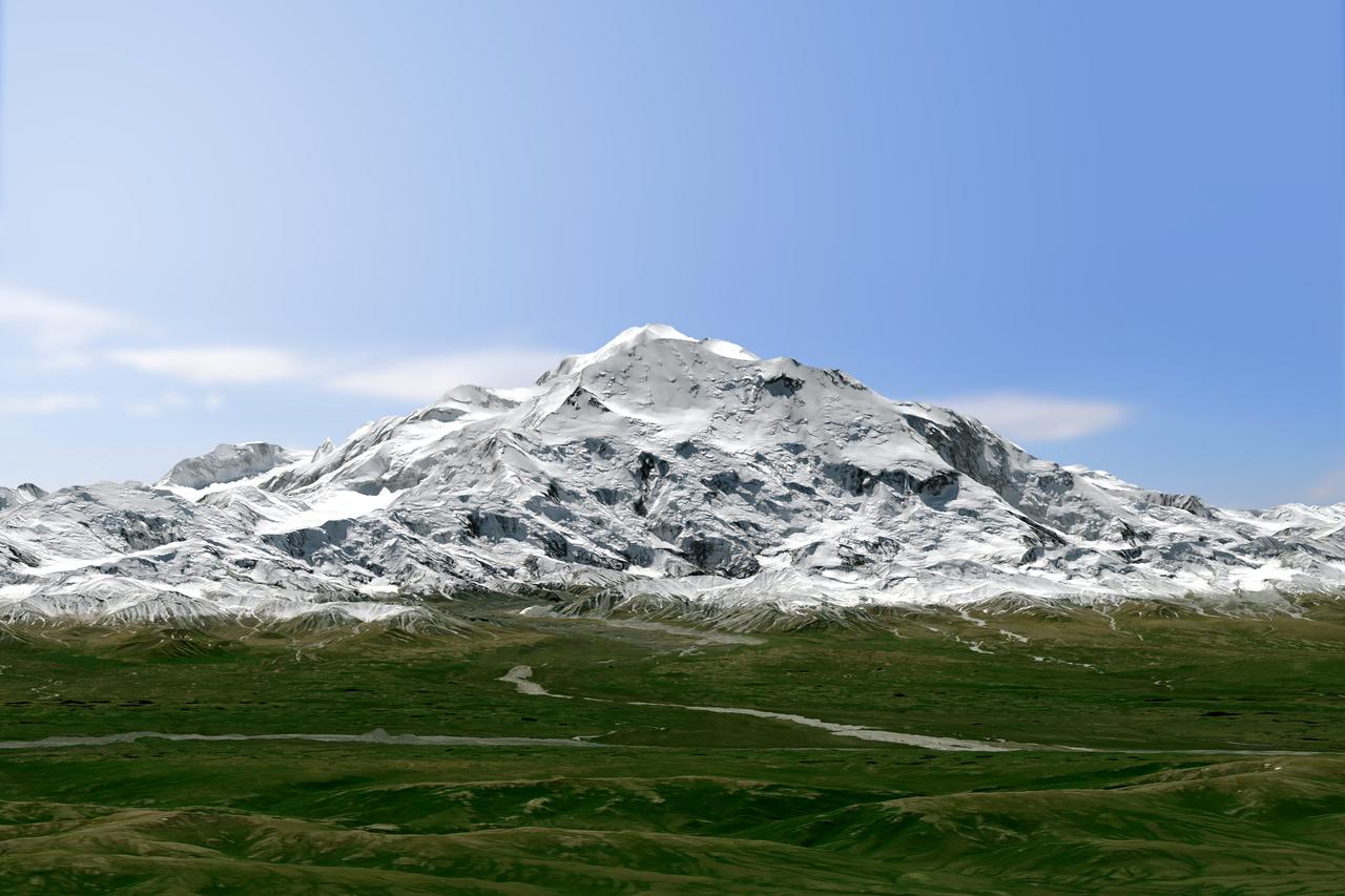
Physically, not too much has changed on Denali, North America’s highest peak. What did change in 2015 is how people describe and measure Alaska’s majestic mountain. On August 30, 2015, U.S. Secretary of the Interior Sally Jewell announced that the mountain’s official name would be Denali, not Mount McKinley. Restoration of the traditional Koyukon Athabascan name of Denali, which means “the tall one,” resolved a request by former Alaska Gov. Jay Hammond that dates back to 1975. But the mountain’s name was not the only change. On September 2, its elevation was also revised. The U.S. Geological Survey announced that Denali’s summit had a new, official elevation of 20,310 feet (6,190 meters)—10 feet shorter than surveyors had determined in the 1950s. The mountain has not shrunk. Instead, technology has improved. The images on this page offer two views of Denali as observed on June 15, 2015, by the Operational Land Imager (OLI) on Landsat 8. The natural-color Landsat 8 images were draped over an ASTER-derived Global Digital Elevation Model, which helps show the topography of the area. Read more: <a href="http://1.usa.gov/1QbmOFP" rel="nofollow">1.usa.gov/1QbmOFP</a> <b><a href="http://www.nasa.gov/audience/formedia/features/MP_Photo_Guidelines.html" rel="nofollow">NASA image use policy.</a></b> <b><a href="http://www.nasa.gov/centers/goddard/home/index.html" rel="nofollow">NASA Goddard Space Flight Center</a></b> enables NASA’s mission through four scientific endeavors: Earth Science, Heliophysics, Solar System Exploration, and Astrophysics. Goddard plays a leading role in NASA’s accomplishments by contributing compelling scientific knowledge to advance the Agency’s mission. <b>Follow us on <a href="http://twitter.com/NASAGoddardPix" rel="nofollow">Twitter</a></b> <b>Like us on <a href="http://www.facebook.com/pages/Greenbelt-MD/NASA-Goddard/395013845897?ref=tsd" rel="nofollow">Facebook</a></b> <b>Find us on <a href="http://instagrid.me/nasagoddard/?vm=grid" rel="nofollow">Instagram</a></b>
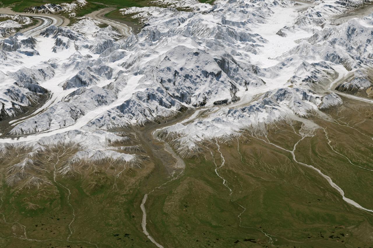
Physically, not too much has changed on Denali, North America’s highest peak. What did change in 2015 is how people describe and measure Alaska’s majestic mountain. On August 30, 2015, U.S. Secretary of the Interior Sally Jewell announced that the mountain’s official name would be Denali, not Mount McKinley. Restoration of the traditional Koyukon Athabascan name of Denali, which means “the tall one,” resolved a request by former Alaska Gov. Jay Hammond that dates back to 1975. But the mountain’s name was not the only change. On September 2, its elevation was also revised. The U.S. Geological Survey announced that Denali’s summit had a new, official elevation of 20,310 feet (6,190 meters)—10 feet shorter than surveyors had determined in the 1950s. The mountain has not shrunk. Instead, technology has improved. The images on this page offer two views of Denali as observed on June 15, 2015, by the Operational Land Imager (OLI) on Landsat 8. The natural-color Landsat 8 images were draped over an ASTER-derived Global Digital Elevation Model, which helps show the topography of the area. Read more: <a href="http://1.usa.gov/1QbmOFP" rel="nofollow">1.usa.gov/1QbmOFP</a> <b><a href="http://www.nasa.gov/audience/formedia/features/MP_Photo_Guidelines.html" rel="nofollow">NASA image use policy.</a></b> <b><a href="http://www.nasa.gov/centers/goddard/home/index.html" rel="nofollow">NASA Goddard Space Flight Center</a></b> enables NASA’s mission through four scientific endeavors: Earth Science, Heliophysics, Solar System Exploration, and Astrophysics. Goddard plays a leading role in NASA’s accomplishments by contributing compelling scientific knowledge to advance the Agency’s mission. <b>Follow us on <a href="http://twitter.com/NASAGoddardPix" rel="nofollow">Twitter</a></b> <b>Like us on <a href="http://www.facebook.com/pages/Greenbelt-MD/NASA-Goddard/395013845897?ref=tsd" rel="nofollow">Facebook</a></b> <b>Find us on <a href="http://instagrid.me/nasagoddard/?vm=grid" rel="nofollow">Instagram</a></b>
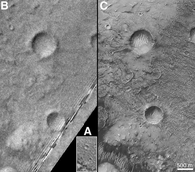
On Earth, the longitude of the Royal Observatory in Greenwich, England is defined as the "prime meridian," or the zero point of longitude. Locations on Earth are measured in degrees east or west from this position. The prime meridian was defined by international agreement in 1884 as the position of the large "transit circle," a telescope in the Observatory's Meridian Building. The transit circle was built by Sir George Biddell Airy, the 7th Astronomer Royal, in 1850. (While visual observations with transits were the basis of navigation until the space age, it is interesting to note that the current definition of the prime meridian is in reference to orbiting satellites and Very Long Baseline Interferometry (VLBI) measurements of distant radio sources such as quasars. This "International Reference Meridian" is now about 100 meters east of the Airy Transit at Greenwich.) For Mars, the prime meridian was first defined by the German astronomers W. Beer and J. H. Mädler in 1830-32. They used a small circular feature, which they designated "a," as a reference point to determine the rotation period of the planet. The Italian astronomer G. V. Schiaparelli, in his 1877 map of Mars, used this feature as the zero point of longitude. It was subsequently named Sinus Meridiani ("Middle Bay") by Camille Flammarion. When Mariner 9 mapped the planet at about 1 kilometer (0.62 mile) resolution in 1972, an extensive "control net" of locations was computed by Merton Davies of the RAND Corporation. Davies designated a 0.5-kilometer-wide crater (0.3 miles wide), subsequently named "Airy-0" (within the large crater Airy in Sinus Meridiani) as the longitude zero point. (Airy, of course, was named to commemorate the builder of the Greenwich transit.) This crater was imaged once by Mariner 9 (the 3rd picture taken on its 533rd orbit, 533B03) and once by the Viking 1 orbiter in 1978 (the 46th image on that spacecraft's 746th orbit, 746A46), and these two images were the basis of the martian longitude system for the rest of the 20th Century. The Mars Global Surveyor (MGS) Mars Orbiter Camera (MOC) has attempted to take a picture of Airy-0 on every close overflight since the beginning of the MGS mapping mission. It is a measure of the difficulty of hitting such a small target that nine attempts were required, since the spacecraft did not pass directly over Airy-0 until almost the end of the MGS primary mission, on orbit 8280 (January 13, 2001). In the left figure above, the outlines of the Mariner 9, Viking, and Mars Global Surveyor images are shown on a MOC wide angle context image, M23-00924. In the right figure, sections of each of the three images showing the crater Airy-0 are presented. A is a piece of the Mariner 9 image, B is from the Viking image, and C is from the MGS image. Airy-0 is the larger crater toward the top-center in each frame. The MOC observations of Airy-0 not only provide a detailed geological close-up of this historic reference feature, they will be used to improve our knowledge of the locations of all features on Mars, which will in turn enable more precise landings on the Red Planet by future spacecraft and explorers. http://photojournal.jpl.nasa.gov/catalog/PIA03207

The blue areas on this map of Mars show regions where NASA missions have detected subsurface water ice. Scientists can use the map – part of the Subsurface Water Ice Mapping project, or SWIM – to decide where the first astronauts to set foot on the Red Planet should land. Triangles on the map are past and present Mars missions; circles are ice-exposing impact craters. Mars has both water ice and carbon dioxide ice (dry ice); water ice would be a critical resource for the first astronauts to step foot on Mars, who can use it for drinking, rocket fuel, and other purposes. The more water ice these astronauts land next to, the less they need to bring with them. Because the Martian atmosphere is so thin – less than 1% the pressure experienced at sea level on Earth – liquid water is unstable on the Red Planet and will vaporize unless it's frozen. But water ice on the planet's surface is only stable at high latitudes that are far too cold for astronauts and robots to survive. So SWIM attempts to locate water ice preserved within the subsurface in the mid-latitudes, where landing would be feasible. Such regions are far enough toward the pole for water ice to be plentiful, but close enough to the equator to avoid the coldest temperatures seen on Mars. SWIM combines data from several NASA missions, including the Mars Reconnaissance Orbiter (MRO), 2001 Mars Odyssey, and the now-inactive Mars Global Surveyor. The project mapped the area from the equator to 60 degrees north latitude. https://photojournal.jpl.nasa.gov/catalog/PIA26045
![This image from NASA's Mars Reconnaissance Orbiter (MRO) shows Mars' surface in detail. Mars has captured the imagination of astronomers for thousands of years, but it wasn't until the last half a century that we were able to capture images of its surface in detail. This particular site on Mars was first imaged in 1965 by the Mariner 4 spacecraft during the first successful fly-by mission to Mars. From an altitude of around 10,000 kilometers, this image (the ninth frame taken) achieved a resolution of approximately 1.25 kilometers per pixel. Since then, this location has been observed by six other visible cameras producing images with varying resolutions and sizes. This includes HiRISE (highlighted in yellow), which is the highest-resolution and has the smallest "footprint." This compilation, spanning Mariner 4 to HiRISE, shows each image at full-resolution. Beginning with Viking 1 and ending with our HiRISE image, this animation documents the historic imaging of a particular site on another world. In 1976, the Viking 1 orbiter began imaging Mars in unprecedented detail, and by 1980 had successfully mosaicked the planet at approximately 230 meters per pixel. In 1999, the Mars Orbiter Camera onboard the Mars Global Surveyor (1996) also imaged this site with its Wide Angle lens, at around 236 meters per pixel. This was followed by the Thermal Emission Imaging System on Mars Odyssey (2001), which also provided a visible camera producing the image we see here at 17 meters per pixel. Later in 2012, the High-Resolution Stereo Camera on the Mars Express orbiter (2003) captured this image of the surface at 25 meters per pixel. In 2010, the Context Camera on the Mars Reconnaissance Orbiter (2005) imaged this site at about 5 meters per pixel. Finally, in 2017, HiRISE acquired the highest resolution image of this location to date at 50 centimeters per pixel. When seen at this unprecedented scale, we can discern a crater floor strewn with small rocky deposits, boulders several meters across, and wind-blown deposits in the floors of small craters and depressions. This compilation of Mars images spanning over 50 years gives us a visual appreciation of the evolution of orbital Mars imaging over a single site. The map is projected here at a scale of 50 centimeters (19.7 inches) per pixel. [The original image scale is 52.2 centimeters (20.6 inches) per pixel (with 2 x 2 binning); objects on the order of 156 centimeters (61.4 inches) across are resolved.] North is up. https://photojournal.jpl.nasa.gov/catalog/PIA22115](https://images-assets.nasa.gov/image/PIA22115/PIA22115~medium.jpg)
This image from NASA's Mars Reconnaissance Orbiter (MRO) shows Mars' surface in detail. Mars has captured the imagination of astronomers for thousands of years, but it wasn't until the last half a century that we were able to capture images of its surface in detail. This particular site on Mars was first imaged in 1965 by the Mariner 4 spacecraft during the first successful fly-by mission to Mars. From an altitude of around 10,000 kilometers, this image (the ninth frame taken) achieved a resolution of approximately 1.25 kilometers per pixel. Since then, this location has been observed by six other visible cameras producing images with varying resolutions and sizes. This includes HiRISE (highlighted in yellow), which is the highest-resolution and has the smallest "footprint." This compilation, spanning Mariner 4 to HiRISE, shows each image at full-resolution. Beginning with Viking 1 and ending with our HiRISE image, this animation documents the historic imaging of a particular site on another world. In 1976, the Viking 1 orbiter began imaging Mars in unprecedented detail, and by 1980 had successfully mosaicked the planet at approximately 230 meters per pixel. In 1999, the Mars Orbiter Camera onboard the Mars Global Surveyor (1996) also imaged this site with its Wide Angle lens, at around 236 meters per pixel. This was followed by the Thermal Emission Imaging System on Mars Odyssey (2001), which also provided a visible camera producing the image we see here at 17 meters per pixel. Later in 2012, the High-Resolution Stereo Camera on the Mars Express orbiter (2003) captured this image of the surface at 25 meters per pixel. In 2010, the Context Camera on the Mars Reconnaissance Orbiter (2005) imaged this site at about 5 meters per pixel. Finally, in 2017, HiRISE acquired the highest resolution image of this location to date at 50 centimeters per pixel. When seen at this unprecedented scale, we can discern a crater floor strewn with small rocky deposits, boulders several meters across, and wind-blown deposits in the floors of small craters and depressions. This compilation of Mars images spanning over 50 years gives us a visual appreciation of the evolution of orbital Mars imaging over a single site. The map is projected here at a scale of 50 centimeters (19.7 inches) per pixel. [The original image scale is 52.2 centimeters (20.6 inches) per pixel (with 2 x 2 binning); objects on the order of 156 centimeters (61.4 inches) across are resolved.] North is up. https://photojournal.jpl.nasa.gov/catalog/PIA22115
The Mars Global Surveyor (MGS) Mars Orbiter Camera (MOC) was designed specifically to provide images of Mars that have a resolution comparable to the aerial photographs commonly used by Earth scientists to study geological processes and map landforms on our home planet. When MGS reaches its Mapping Orbit in March 1999, MOC will be able to obtain pictures with spatial resolutions of 1.5 meters (5 feet) per pixel--this good enough to easily see objects the size of an automobile. Boulders are one of the keys to determining which processes have eroded, transported, and deposited material on Mars (e.g.,landslides, mud flows, flood debris). During the first year in orbit,MGS MOC obtained pictures with resolutions between 2 and 30 meters (7to 98 feet) per pixel. It was found that boulders are difficult to identify on Mars in images with resolutions worse than about 2-3 meters per pixel. Although not known when the MOC was designed,"thresholds" like this are found on Earth, too. The MOC's 1.5 m/pixel resolution was a compromise between (1) the anticipation of such resolution-dependent sensitivity based on our experience with Earth and (2)the cost in terms of mass if we had built a larger telescope to get a higher resolution. Some rather larger boulders (i.e., larger than about 10 meters--or yards--in size) have already been seen on Mars by the orbiting camera. This is a feat similar to that which can be obtained by "spy" satellites on Earth. The MOC image 53104 subframe shown above features a low, rounded hill in southeastern Utopia Planitia. Each of the small, lumpy features on the top of this hill is a boulder. In this picture, boulders are not seen on the surrounding plain. These boulders are interpreted to be the remnants of a layer of harder rock that once covered the top of the hill, but was subsequently eroded and broken up by weathering and wind processes. MOC image 53104 was taken on September 2, 1998. The subframe shows an area 2.2 km by 3.3 km (1.4 miles by 2.7 miles). The image has a resolution of about 3.25 meters (10.7 feet) per pixel. The subframe is centered at 41.0°N latitude and 207.3°W longitude. North is approximately up, illumination is from the left. http://photojournal.jpl.nasa.gov/catalog/PIA01500