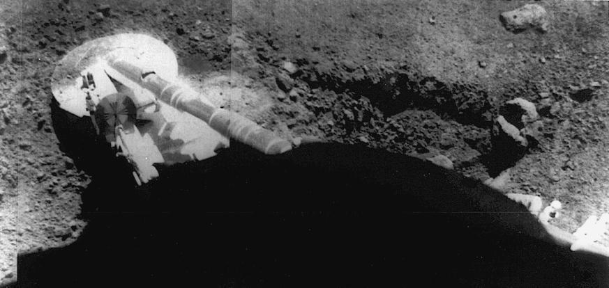
Surveyor 5 image of the footpad resting in the lunar soil. The trench at right was formed by the footpad sliding during landing. Surveyor 5 landed on the Moon on 11 September 1967 at 1.41 N, 23.18E in Mare Tranquillitatis.
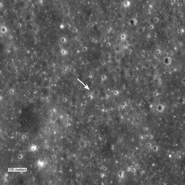
Surveyor 5 sitting in a 10-meter diameter crater. Surveyor 5 landed on Mare Tranquillitatis in September of 1967. This image was taken by NASA Lunar Reconnaissance Orbiter.
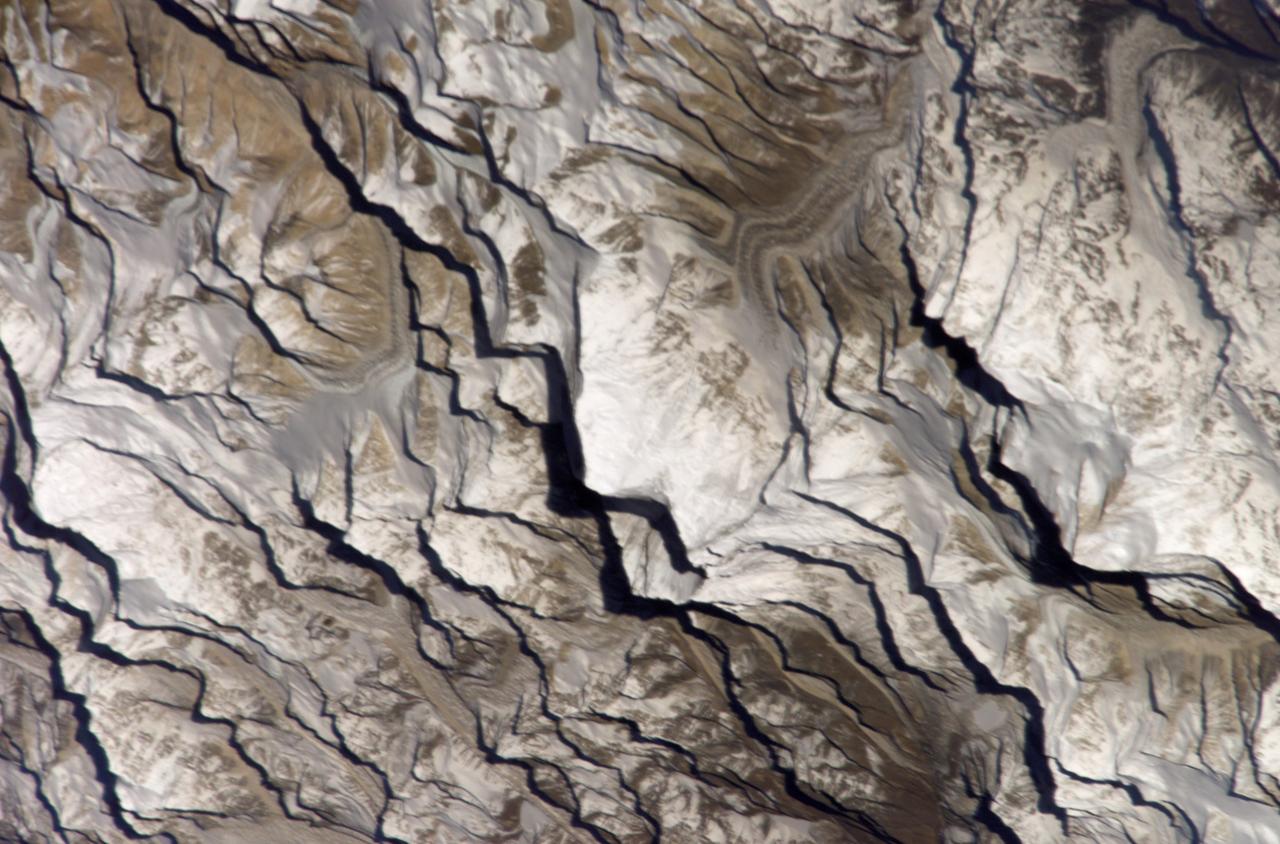
Astronaut Daniel W. Bursch, Expedition Four flight engineer, was delighted in capturing this image of Mt. Everest in the Himalayan Range from aboard the International Space Station (ISS). The mountain is near frame center. Because the photo was taken close to orbital sunrise, the low sun angle gave tremendous relief to the mountains. Named for Sir George Everest, the British surveyor-general of India, Mount Everest is the tallest point on earth. Standing 29,028 feet tall, it is 5 1/2 miles above sea level. Mount Everest is located half in Nepal and half in Tibet.
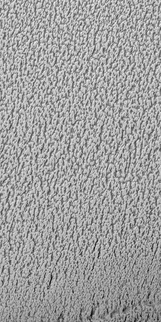
This image is illuminated by sunlight from the upper left. Martian Dairy Products? If parts of the south polar cap can look like swiss cheese (see "Martian "Swiss Cheese""), then parts of the north polar cap might as well look like some kind of cheese, too. This picture shows a cottage cheese-like texture on the surface of a part of the residual--summertime--north polar cap. The north polar cap surface is mostly covered by pits, cracks, small bumps and knobs. In this image, the cap surface appears bright and the floors of pits look dark. Based upon observations made by the Mariner 9 and Viking orbiters in the 1970s, the north polar residual cap is thought to contain mostly water ice because its summertime temperature is usually near the freezing point of water and water vapor was observed by the Vikings to be coming off the cap during summer. The south residual cap is different--its temperatures in summer remain cold enough to freeze carbon dioxide, and very little to no water vapor has been observed to come off the south cap in summer. The pits that have developed on the north polar cap surface are closely-spaced relative to the very different depressions in the south polar cap. The pits are estimated from the length of shadows cast in them to be less than about 2 meters (5.5 feet) deep. These pits probably develop slowly over thousands of years of successive spring and summer seasons. This picture was taken by the Mars Global Surveyor (MGS) Mars Orbiter Camera (MOC) during northern summer on April 5, 1999. The picture is located near 82.1°N, 329.6°W and covers an area 1.5 km wide by 3 km long (0.9 x 1.8 miles) at a resolution of 3 meters (10 ft) per pixel. http://photojournal.jpl.nasa.gov/catalog/PIA02369
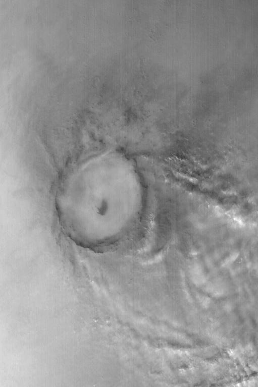
Mie Crater, a large basin formed by asteroid or comet impact in Utopia Planitia, lies at the center of this Mars Global Surveyor (MGS) Mars Orbiter Camera (MOC) red wide angle image. The crater is approximately 104 km (65 mi) across. To the east and southeast (toward the lower right) of Mie, in this 5 December 2003 view, are clouds of dust and water ice kicked up by local dust storm activity. It is mid-winter in the northern hemisphere of Mars, a time when passing storms are common on the northern plains of the red planet. Sunlight illuminates this image from the lower left; Mie Crater is located at 48.5°N, 220.3°W. Viking 2 landed west/southwest of Mie Crater, off the left edge of this image, in September 1976. http://photojournal.jpl.nasa.gov/catalog/PIA04930
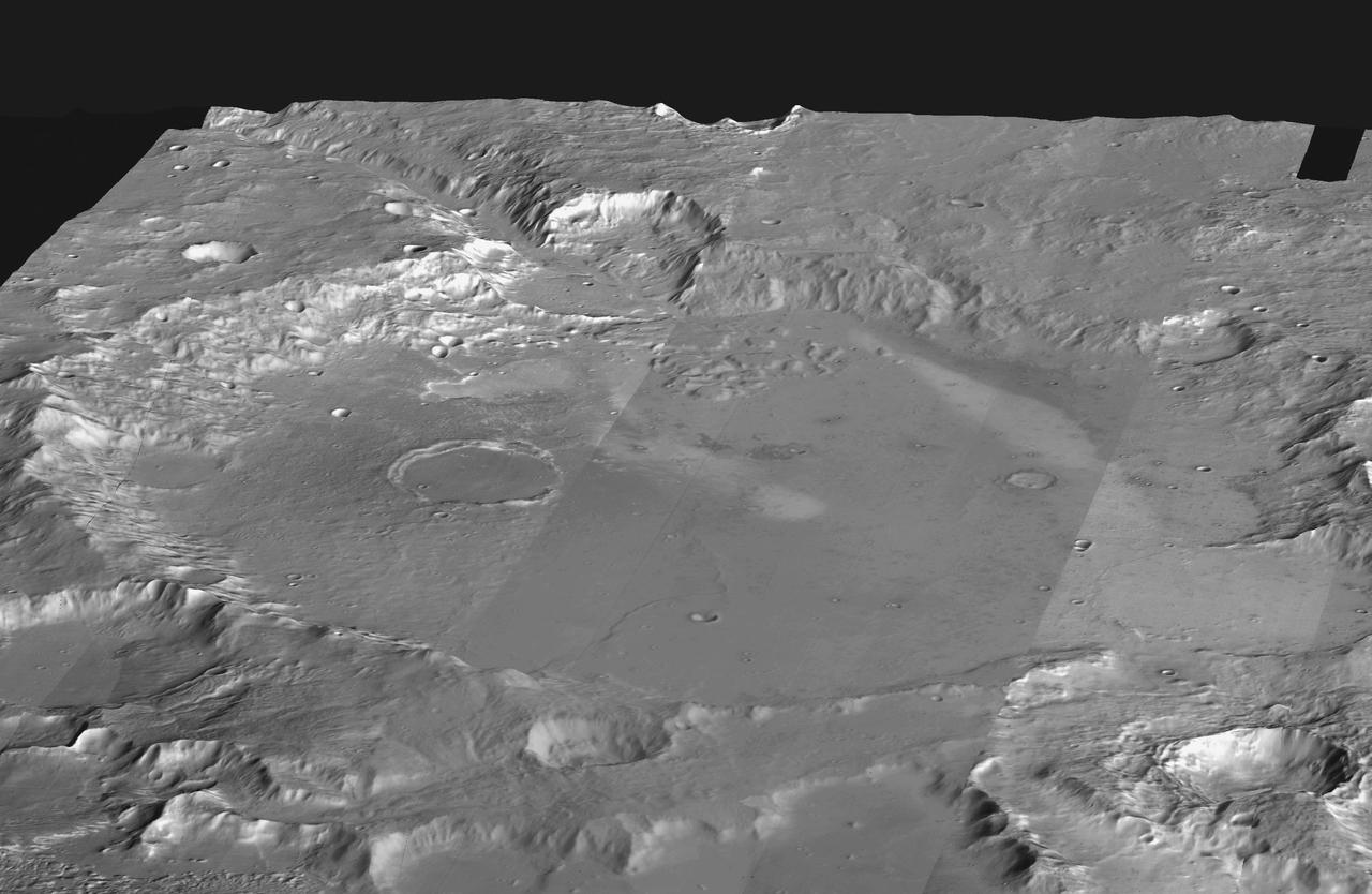
This mosaic of daytime infrared images of Gusev Crater, taken by NASA Mars Odyssey spacecraft, has been draped over topography data obtained by NASA Mars Global Surveyor. The daytime temperatures range from approximately minus 45 degrees C (black) to minus 5 degrees C (white). The temperature differences in these daytime images are due primarily to lighting effects, where sunlit slopes are warm (bright) and shadowed slopes are cool (dark). Gusev crater is a potential landing site for the Mars Exploration Rovers. The large ancient river channel of Ma'Adim that once flowed into Gusev can be seen at the top of the mosaic. This image mosaic covers an area approximately 180 kilometers (110 miles) on each side centered near 14 degrees S, 175 degrees E, looking toward the south in this simulated view. http://photojournal.jpl.nasa.gov/catalog/PIA04260
This picture is illuminated by sunlight from the upper left. Some portions of the martian south polar residual cap have long, somewhat curved troughs instead of circular pits. These appear to form in a layer of material that may be different than that in which "swiss cheese" circles and pits form, and none of these features has any analog in the north polar cap or elsewhere on Mars. This picture shows the "fingerprint" terrain as a series of long, narrow depressions considered to have formed by collapse and widening by sublimation of ice. Unlike the north polar cap, the south polar region stays cold enough in summer to retain frozen carbon dioxide. Viking Orbiter observations during the late 1970s showed that very little water vapor comes off the south polar cap during summer, indicating that any frozen water that might be there remains solid throughout the year. This Mars Global Surveyor (MGS) Mars Orbiter Camera (MOC) image was obtained in early southern spring on August 4, 1999. It shows an area 3 x 5 kilometers (1.9 x 3.1 miles) at a resolution of about 7.3 meters (24 ft) per pixel. Located near 86.0°S, 53.9°W. http://photojournal.jpl.nasa.gov/catalog/PIA02373
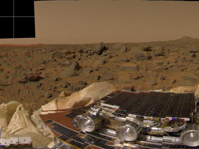
This picture from Mars Pathfinder was taken at 9:30 AM in the martian morning (2:30 PM Pacific Daylight Time), after the spacecraft landed earlier today (July 4, 1997). The Sojourner rover is perched on one of three solar panels. The rover is 65 cm (26 inches) long by 18 cm (7 inches) tall; each of its wheels is about 13 cm (5 inches) high. The white material to the left of the front of the rover is part of the airbag system used to cushion the landing. Many rocks of different of different sizes can be seen, set in a background of reddish soil. The landing site is in the mouth of an ancient channel carved by water. The rocks may be primarily flood debris. The horizon is seen towards the top of the picture. The light brown hue of the sky results from suspended dust. Pathfinder, a low-cost Discovery mission, is the first of a new fleet of spacecraft that are planned to explore Mars over the next ten years. Mars Global Surveyor, already en route, arrives at Mars on September 11 to begin a two year orbital reconnaissance of the planet's composition, topography, and climate. Additional orbiters and landers will follow every 26 months. http://photojournal.jpl.nasa.gov/catalog/PIA00608
This false-color infrared image was taken by the camera system on the Mars Odyssey spacecraft over part of Ganges Chasma in Valles Marineris (approximately 13 degrees S, 318 degrees E). The infrared image has been draped over topography data obtained by Mars Global Surveyor. The color differences in this image show compositional variations in the rocks exposed in the wall and floor of Ganges (blue and purple) and in the dust and sand on the rim of the canyon (red and orange). The floor of Ganges is covered by rocks and sand composed of basaltic lava that are shown in blue. A layer that is rich in the mineral olivine can be seen as a band of purple in the walls on both sides of the canyon, and is exposed as an eroded layer surrounding a knob on the floor. Olivine is easily destroyed by liquid water, so its presence in these ancient rocks suggests that this region of Mars has been very dry for a very long time. The mosaic was constructed using infrared bands 5, 7, and 8, and covers an area approximately 150 kilometers (90 miles) on each side. This simulated view is toward the north. http://photojournal.jpl.nasa.gov/catalog/PIA04262
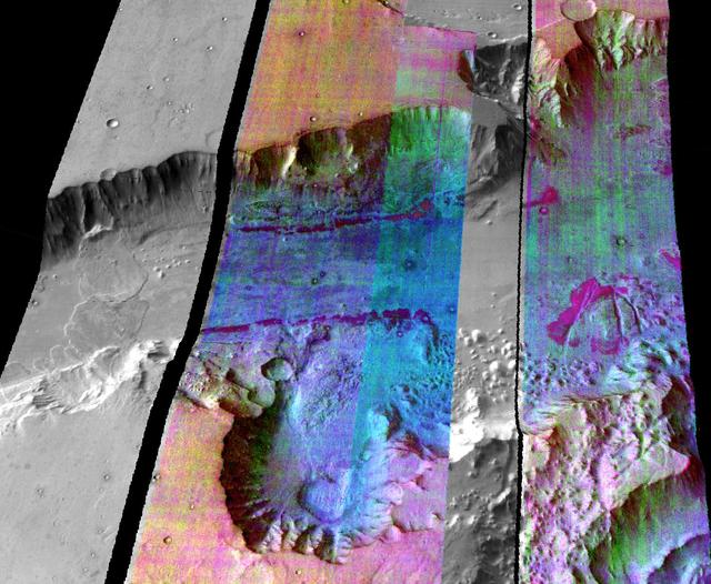
Images of the Cydonia region of Mars continue to be popular among visitors to the Mars Global Surveyor (MGS) Mars Orbiter Camera (MOC)web site. The two pictures (one annotated, the other not) are mosaics of two images from MGS MOC and one from the Mars Odyssey Thermal Emission Imaging System visible camera (THEMIS VIS). The mosaics highlight a Cydonia landform popularly known as the "D&M Pyramid." It is located near 40.7°N, 9.6°W. Although it is not really shaped like a pyramid, the Cydonia landform is one of thousands of massifs, buttes, mesas, knobs, and blocks that mark the transition from the far northwestern Arabia Terra cratered highlands down to the northeastern Acidalia Planitia lowlands. Each block, whether shaped like a face, a pyramid, or simply a mesa, massif, or knob, is a remnant of the bedrock of northeastern Arabia that was left behind as erosion slowly degraded the terrain along this zone between the highlands and the lowlands. A few outcroppings of layers in this ancient bedrock can be seen in the mosaic of the pyramid-like landform shown here; much of the landform is covered with eroded mantling material that was deposited long after this highlands remnant became an isolated feature in Cydonia. The mosaic was created from two MOC images obtained in June (R06-00469) and July (R07-00422) of 2003 and one THEMIS VIS image acquired in 2002 (V01024003). The mosaic is 8 km by 8 km (5 mi by 5 mi) across and each of the three images is illuminated from the lower left. North is up. The picture on the right shows the location of the two MOC images as black outlines; the THEMIS image not only covers the gap between the two MOC images, it also fills out the lower left and upper right corners. http://photojournal.jpl.nasa.gov/catalog/PIA04745
The Mars Global Surveyor (MGS) Mars Orbiter Camera (MOC) was designed specifically to provide images of Mars that have a resolution comparable to the aerial photographs commonly used by Earth scientists to study geological processes and map landforms on our home planet. When MGS reaches its Mapping Orbit in March 1999, MOC will be able to obtain pictures with spatial resolutions of 1.5 meters (5 feet) per pixel--this good enough to easily see objects the size of an automobile. Boulders are one of the keys to determining which processes have eroded, transported, and deposited material on Mars (e.g.,landslides, mud flows, flood debris). During the first year in orbit,MGS MOC obtained pictures with resolutions between 2 and 30 meters (7to 98 feet) per pixel. It was found that boulders are difficult to identify on Mars in images with resolutions worse than about 2-3 meters per pixel. Although not known when the MOC was designed,"thresholds" like this are found on Earth, too. The MOC's 1.5 m/pixel resolution was a compromise between (1) the anticipation of such resolution-dependent sensitivity based on our experience with Earth and (2)the cost in terms of mass if we had built a larger telescope to get a higher resolution. Some rather larger boulders (i.e., larger than about 10 meters--or yards--in size) have already been seen on Mars by the orbiting camera. This is a feat similar to that which can be obtained by "spy" satellites on Earth. The MOC image 53104 subframe shown above features a low, rounded hill in southeastern Utopia Planitia. Each of the small, lumpy features on the top of this hill is a boulder. In this picture, boulders are not seen on the surrounding plain. These boulders are interpreted to be the remnants of a layer of harder rock that once covered the top of the hill, but was subsequently eroded and broken up by weathering and wind processes. MOC image 53104 was taken on September 2, 1998. The subframe shows an area 2.2 km by 3.3 km (1.4 miles by 2.7 miles). The image has a resolution of about 3.25 meters (10.7 feet) per pixel. The subframe is centered at 41.0°N latitude and 207.3°W longitude. North is approximately up, illumination is from the left. http://photojournal.jpl.nasa.gov/catalog/PIA01500
![This image from NASA's Mars Reconnaissance Orbiter (MRO) shows Mars' surface in detail. Mars has captured the imagination of astronomers for thousands of years, but it wasn't until the last half a century that we were able to capture images of its surface in detail. This particular site on Mars was first imaged in 1965 by the Mariner 4 spacecraft during the first successful fly-by mission to Mars. From an altitude of around 10,000 kilometers, this image (the ninth frame taken) achieved a resolution of approximately 1.25 kilometers per pixel. Since then, this location has been observed by six other visible cameras producing images with varying resolutions and sizes. This includes HiRISE (highlighted in yellow), which is the highest-resolution and has the smallest "footprint." This compilation, spanning Mariner 4 to HiRISE, shows each image at full-resolution. Beginning with Viking 1 and ending with our HiRISE image, this animation documents the historic imaging of a particular site on another world. In 1976, the Viking 1 orbiter began imaging Mars in unprecedented detail, and by 1980 had successfully mosaicked the planet at approximately 230 meters per pixel. In 1999, the Mars Orbiter Camera onboard the Mars Global Surveyor (1996) also imaged this site with its Wide Angle lens, at around 236 meters per pixel. This was followed by the Thermal Emission Imaging System on Mars Odyssey (2001), which also provided a visible camera producing the image we see here at 17 meters per pixel. Later in 2012, the High-Resolution Stereo Camera on the Mars Express orbiter (2003) captured this image of the surface at 25 meters per pixel. In 2010, the Context Camera on the Mars Reconnaissance Orbiter (2005) imaged this site at about 5 meters per pixel. Finally, in 2017, HiRISE acquired the highest resolution image of this location to date at 50 centimeters per pixel. When seen at this unprecedented scale, we can discern a crater floor strewn with small rocky deposits, boulders several meters across, and wind-blown deposits in the floors of small craters and depressions. This compilation of Mars images spanning over 50 years gives us a visual appreciation of the evolution of orbital Mars imaging over a single site. The map is projected here at a scale of 50 centimeters (19.7 inches) per pixel. [The original image scale is 52.2 centimeters (20.6 inches) per pixel (with 2 x 2 binning); objects on the order of 156 centimeters (61.4 inches) across are resolved.] North is up. https://photojournal.jpl.nasa.gov/catalog/PIA22115](https://images-assets.nasa.gov/image/PIA22115/PIA22115~medium.jpg)
This image from NASA's Mars Reconnaissance Orbiter (MRO) shows Mars' surface in detail. Mars has captured the imagination of astronomers for thousands of years, but it wasn't until the last half a century that we were able to capture images of its surface in detail. This particular site on Mars was first imaged in 1965 by the Mariner 4 spacecraft during the first successful fly-by mission to Mars. From an altitude of around 10,000 kilometers, this image (the ninth frame taken) achieved a resolution of approximately 1.25 kilometers per pixel. Since then, this location has been observed by six other visible cameras producing images with varying resolutions and sizes. This includes HiRISE (highlighted in yellow), which is the highest-resolution and has the smallest "footprint." This compilation, spanning Mariner 4 to HiRISE, shows each image at full-resolution. Beginning with Viking 1 and ending with our HiRISE image, this animation documents the historic imaging of a particular site on another world. In 1976, the Viking 1 orbiter began imaging Mars in unprecedented detail, and by 1980 had successfully mosaicked the planet at approximately 230 meters per pixel. In 1999, the Mars Orbiter Camera onboard the Mars Global Surveyor (1996) also imaged this site with its Wide Angle lens, at around 236 meters per pixel. This was followed by the Thermal Emission Imaging System on Mars Odyssey (2001), which also provided a visible camera producing the image we see here at 17 meters per pixel. Later in 2012, the High-Resolution Stereo Camera on the Mars Express orbiter (2003) captured this image of the surface at 25 meters per pixel. In 2010, the Context Camera on the Mars Reconnaissance Orbiter (2005) imaged this site at about 5 meters per pixel. Finally, in 2017, HiRISE acquired the highest resolution image of this location to date at 50 centimeters per pixel. When seen at this unprecedented scale, we can discern a crater floor strewn with small rocky deposits, boulders several meters across, and wind-blown deposits in the floors of small craters and depressions. This compilation of Mars images spanning over 50 years gives us a visual appreciation of the evolution of orbital Mars imaging over a single site. The map is projected here at a scale of 50 centimeters (19.7 inches) per pixel. [The original image scale is 52.2 centimeters (20.6 inches) per pixel (with 2 x 2 binning); objects on the order of 156 centimeters (61.4 inches) across are resolved.] North is up. https://photojournal.jpl.nasa.gov/catalog/PIA22115
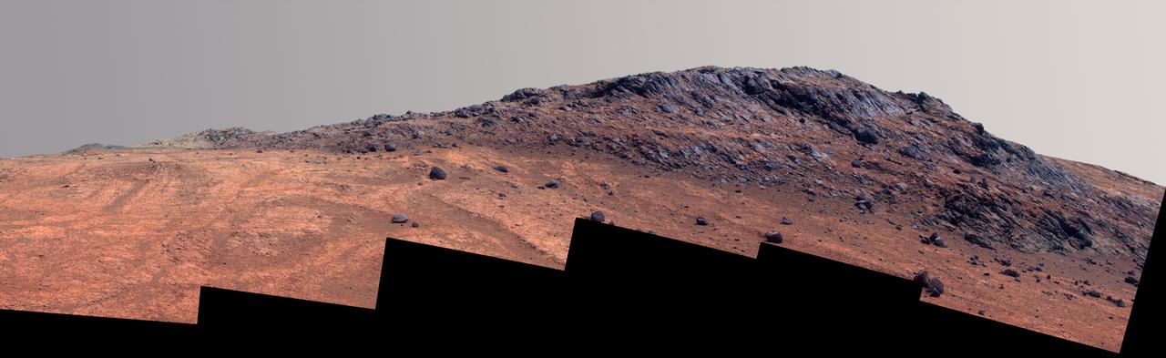
This Martian scene shows contrasting textures and colors of "Hinners Point," at the northern edge of "Marathon Valley," and swirling reddish zones on the valley floor to the left. In this version of the image, the landscape is presented in enhanced color to make differences in surface materials more easily visible. The summit takes its informal name as a tribute to Noel Hinners (1935-2014). For NASA's Apollo program, Hinners played important roles in selection of landing sites on the moon and scientific training of astronauts. He then served as NASA associate administrator for space science, director of the Smithsonian National Air and Space Museum, director of NASA's Goddard Space Flight Center, NASA chief scientist and associate deputy administrator of NASA. Subsequent to responsibility for the Viking Mars missions while at NASA, he spent the latter part of his career as vice president for flight systems at Lockheed Martin, where he had responsibility for the company's roles in development and operation of NASA's Mars Global Surveyor, Mars Reconnaissance Orbiter, Mars Odyssey, Phoenix Mars Lander, Stardust and Genesis missions. Marathon Valley cuts generally east-west through the western rim of Endeavour Crater. The valley's name refers to the distance Opportunity drove from its 2004 landing site to arrival at this location in 2014. The valley was a high-priority destination for the rover mission because observations from orbit detected clay minerals there. Dark rocks on Hinners Point show a pattern dipping downward toward the interior of Endeavour, to the right from this viewing angle. The strong dip may have resulted from the violence of the impact event that excavated the crater. Brighter rocks make up the valley floor. The reddish zones there may be areas where water has altered composition. Inspections by Opportunity have found compositions there are higher in silica and lower in iron than the typical composition of rocks on Endeavour's rim. The scene spans from west-southwest at left to northwest at right. The larger of two stones close to each other in the foreground left of center is about 5 inches (12 centimeters) wide. On bright bedrock to the right of those stones, Opportunity inspected a target informally named "Pvt. George Gibson." Another inspected target, "Pvt. Silas Goodrich," is on the valley floor near the left edge of this scene. The informal names for these targets refer to members of the Lewis and Clark expedition's Corps of Discovery. The image combines exposures taken through three of the Pancam's color filters, centered on wavelengths of 753 nanometers (near-infrared), 535 nanometers (green) and 432 nanometers (violet). http://photojournal.jpl.nasa.gov/catalog/PIA19820
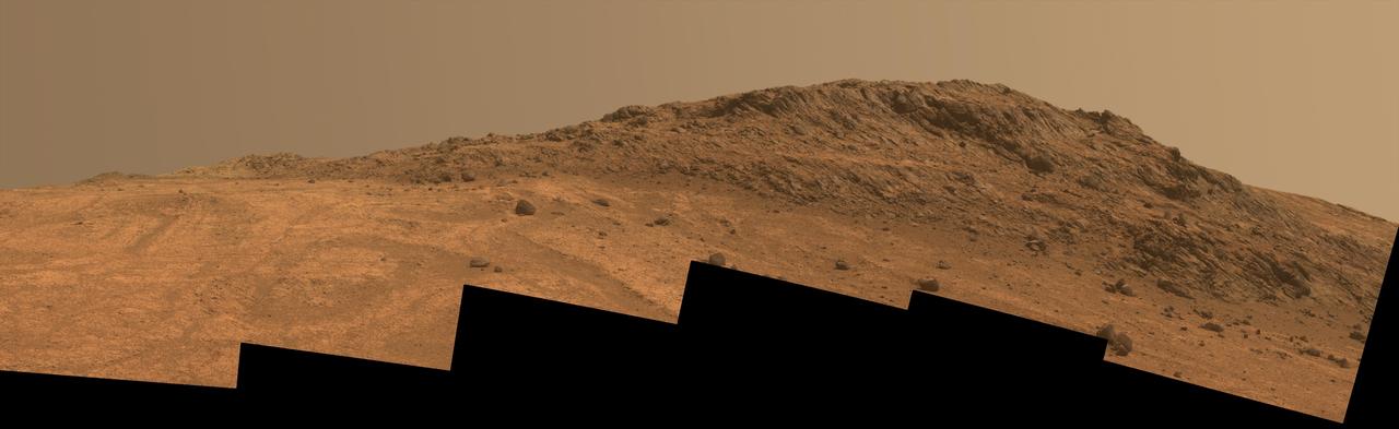
This Martian scene shows contrasting textures and colors of "Hinners Point," at the northern edge of "Marathon Valley," and swirling reddish zones on the valley floor to the left. The view combines six frames taken by the panoramic camera (Pancam) on NASA's Mars Exploration Rover Opportunity on Aug. 14, 2015, during the 4,108th Martian day, or sol, of the rover's work on Mars. The summit takes its informal name as a tribute to Noel Hinners (1935-2014). For NASA's Apollo program, Hinners played important roles in selection of landing sites on the moon and scientific training of astronauts. He then served as NASA associate administrator for space science, director of the Smithsonian National Air and Space Museum, director of NASA's Goddard Space Flight Center, NASA chief scientist and associate deputy administrator of NASA. Subsequent to responsibility for the Viking Mars missions while at NASA, he spent the latter part of his career as vice president for flight systems at Lockheed Martin, where he had responsibility for the company's roles in development and operation of NASA's Mars Global Surveyor, Mars Reconnaissance Orbiter, Mars Odyssey, Phoenix Mars Lander, Stardust and Genesis missions. Marathon Valley cuts generally east-west through the western rim of Endeavour Crater. The valley's name refers to the distance Opportunity drove from its 2004 landing site to arrival at this location in 2014. The valley was a high-priority destination for the rover mission because observations from orbit detected clay minerals there. Dark rocks on Hinners Point show a pattern dipping downward toward the interior of Endeavour, to the right from this viewing angle. The strong dip may have resulted from the violence of the impact event that excavated the crater. Brighter rocks make up the valley floor. The reddish zones there may be areas where water has altered composition. Inspections by Opportunity have found compositions there are higher in silica and lower in iron than the typical composition of rocks on Endeavour's rim. The scene spans from west-southwest at left to northwest at right. The larger of two stones close to each other in the foreground left of center is about 5 inches (12 centimeters) wide. On bright bedrock to the right of those stones, Opportunity inspected a target informally named "Pvt. George Gibson." Another inspected target, "Pvt. Silas Goodrich," is on the valley floor near the left edge of this scene. The informal names for these targets refer to members of the Lewis and Clark expedition's Corps of Discovery. This version of the image is presented in approximate true color by combing exposures taken through three of the Pancam's color filters, centered on wavelengths of 753 nanometers (near-infrared), 535 nanometers (green) and 432 nanometers (violet). http://photojournal.jpl.nasa.gov/catalog/PIA19819
As we head into the 21st Century, it seems hard to believe that human beings have been sending spacecraft toward Mars for more than 3 decades already. The first spacecraft to reach Mars was Mariner 4 in 1965. This success was followed by two spacecraft in 1969, Mariners 6 and 7. Now the wonders and alien beauty of Mars continue to unfold with each day that the Mars Global Surveyor -- which arrived in September 1997 -- continues to radio its data to Earth. Mars exploration was always difficult and each bit of data returned from the planet is a marvel. On August 5, 1969, the Mariner 7 spacecraft flew past Mars at a minimum altitude of about 4200 km. It acquired 14 wide/narrow angle image pairs during the few minutes of the "near encounter" flyby. One of these image pairs, 7N19/7N20, shows the south polar region and contains a feature that at the time was nicknamed "the Giant's Footprint." Shown in the first two pictures, above, the feature consists of two adjoining craters, one about 80 km (50 mi) in diameter and the other about 50 km (31 mi) across near latitude 76°S, longitude 276°W. The oblique geometry of the Mariner 7 image enhances the impression of a footprint. The "Giant's Footprint" was almost missed when Mariner 7 suffered a near-catastrophic battery failure just a few days before the encounter -- on July 30 -- that put the spacecraft sporadically out of contact with Earth for two days. Ground controllers at the Jet Propulsion Laboratory (JPL)recovered the spacecraft, re-planned its imaging sequence based on results from the Mariner 6 flyby on July 31, and salvaged all of the mission's science goals in under a week! In the 1970's, the larger crater in "giant's footprint" was named "Vishniac" in honor of Wolf Vishniac, an American microbiologist of the University of Rochester who was instrumental in the development of methods to search for life on Mars. Vishniac was tragically killed in a fall in Antarctica in 1973 while retrieving a life detection experiment, and the crater was named in honor of this "giant" in the search for life on Mars. More than three decades after the Mariner 7 flyby, Mars Global Surveyor's Mars Orbiter Camera (MOC) acquired a commemorative view of the interior of Vishniac Crater on October 25, 1999. The context image and the 3-meters (9.8 feet)-per-pixel narrow angle view are shown above (in the lower image pair). Mariner 7's 7N20 has a nominal resolution of about 180 meters (591 feet) per pixel, while the MOC high resolution view is about 60 times higher (in actuality, the lower quality of the Mariner 7 images makes the resolution gain even more dramatic). The MOC high resolution view (lower right, above) shows a 1.5 kilometer-(0.9 mile)-wide portion of the floor of Vishniac in the process of defrosting during southern spring. The bright areas are still frost-covered, while the darker areas are either defrosted or composed of darkened or "dirty" frost. The dark patches in the image seem to serve as sources for dark streaks of material that has either been blown across the landscape by wind, or has somehow caused the erosion of frost to create the streaks. Dark streaks follow the local topography, as might the wind that blew across this landscape. This pattern of spots and streaks was quite common on the defrosting south polar cap during the spring that lasted from early August 1999 to late December 1999. All images shown here are illuminated by sunlight from the lower right. Image orientation with north toward the bottom was selected in order to show the "footprint" visible in Mariner 7 image 7N20. The Mariner 7 images were recovered at Malin Space Science Systems from the original 7-track magnetic tapes, archived on CD-ROM by the JPL Data Preservation activity. More images relating to the release can be viewed at http://photojournal.jpl.nasa.gov/catalog/PIA02365