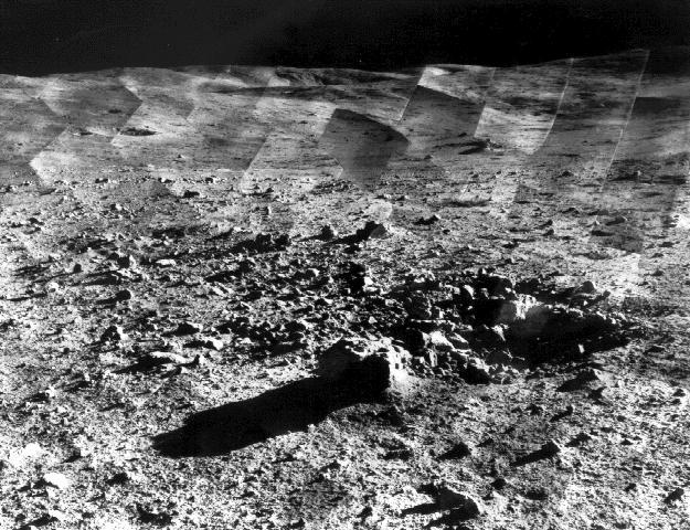
Photomosaic of lunar panorama near the Tycho crater taken by Surveyor 7. The hills on the center horizon are about eight miles away from the spacecraft.

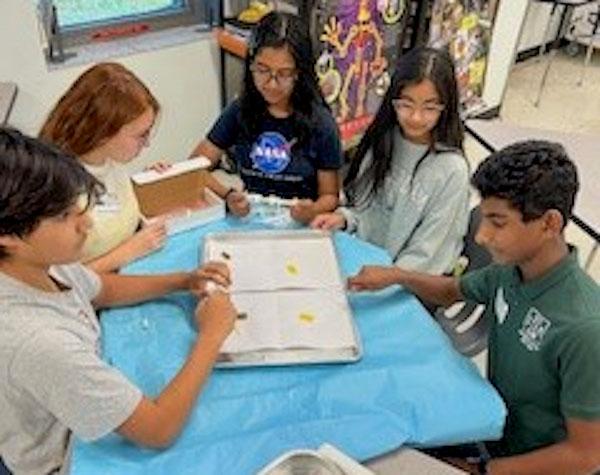
jsc2024e066519 (10/7/2024) --- The Comets set up the test tubes for the final trial of their experiment, Effects of Microgravity on Arabidopsis thaliana Seed Germination. Their experiment is part of the Nanoracks-National Center for Earth and Space Science Education-Surveyor-Student Spaceflight Experiments Program Mission 18 to ISS (Nanoracks-NCESSE-Surveyor-SSEP).

jsc2024e066522 (10/7/2024) --- Moreno Valley Unified School District students explore the effects of microgravity on a popular leafy green. Their experiment, The Effects of Microgravity on Arugula, is part of the Nanoracks-National Center for Earth and Space Science Education-Surveyor-Student Spaceflight Experiments Program Mission 18 to ISS (Nanoracks-NCESSE-Surveyor-SSEP).
jsc2024e066526 (10/7/2024) --- Randall Middle School students work to optimize the materials and volumes for testing the growth of Trigonella foenum-graecum in microgravity. Their experiment, Fenugreek and its Nutritional Value in Microgravity, is part of the Nanoracks-National Center for Earth and Space Science Education-Surveyor-Student Spaceflight Experiments Program Mission 18 to ISS (Nanoracks-NCESSE-Surveyor-SSEP).

jsc2024e066531 (10/7/2024) --- Garden City Middle School students Anjali P. Motwani and Tanya Oza work on their experiment, The Effects of Microgravity on Salvia hispanica Seeds. Their experiment is part of the Nanoracks-National Center for Earth and Space Science Education-Surveyor-Student Spaceflight Experiments Program Mission 18 to ISS (Nanoracks-NCESSE-Surveyor-SSEP).

jsc2024e066529 (10/7/2024) --- The Pepper Elementary student team utilizes microscopy to investigate Citrullus lanatus (watermelon) seeds while preparing sample experiments to continue research.Their experiment, How Watermelon Germinates in Space Versus on Earth, is part of the Nanoracks-National Center for Earth and Space Science Education-Surveyor-Student Spaceflight Experiments Program Mission 18 to ISS (Nanoracks-NCESSE-Surveyor-SSEP).
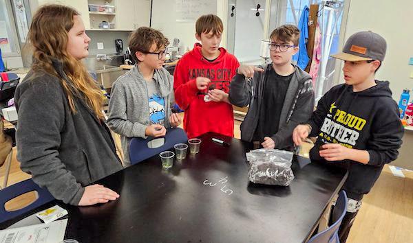
jsc2024e066524 (10/7/2024) --- High Plains School students Maelle Webb, Conor Greene, Aiden Gonzalez, Lee Soyland, and Zachary Collins discuss trial protocols for their experiment, Capsicum annuum Seed Germination in Microgravity. Their experiment is part of the Nanoracks-National Center for Earth and Space Science Education-Surveyor-Student Spaceflight Experiments Program Mission 18 to ISS (Nanoracks-NCESSE-Surveyor-SSEP).
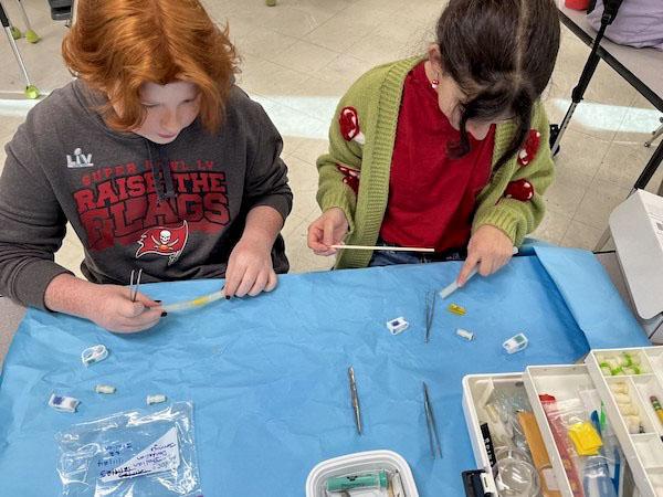
jsc2024e066525 (10/7/2024) --- Seventh grade researchers from Randall Middle School work on optimizing their Taraxacum officinale germination experiment, Handy Dandy Dandelions – Germination of Dandelion in Microgravity, for flight.Their experiment is part of the Nanoracks-National Center for Earth and Space Science Education-Surveyor-Student Spaceflight Experiments Program Mission 18 to ISS (Nanoracks-NCESSE-Surveyor-SSEP).

At NASA's Jet Propulsion Laboratory in Southern California, on June 7, 2024, clean room technicians use a crane to lift the lid of the Medium Articulating Transportation System (MATS) that will be used during the construction and transportation of components for NASA's Near-Earth Object Surveyor mission. Inside the MATS is the Medium Articulating Assembly Dolly (MAAD), a platform that will support the spacecraft's instrument enclosure, which is being constructed inside the High Bay 1 clean room at JPL's Spacecraft Assembly Facility. The MAAD is an articulating platform on which a spacecraft (or spacecraft components) can be mounted securely and positioned as required during assembly. It can tilt a spacecraft vertically and horizontally, rotating it 360 degrees. JPL plans to use the MAAD for future missions to reduce the number of crane lifts during assembly, test, and launch operations, known as ATLO. NEO Surveyor is the first mission to use the platform. NEO Surveyor's instrument enclosure contains the spacecraft's telescope, mirrors, and infrared sensors that will be used to detect, track, and characterize the most hazardous near-Earth objects. BAE Systems, Space Dynamics Laboratory, and Teledyne are among the aerospace and engineering companies contracted to build the spacecraft and its instrumentation. The Laboratory for Atmospheric and Space Physics at the University of Colorado, Boulder will support operations, and IPAC at Caltech in Pasadena, California, is responsible for processing survey data and producing the mission's data products. JPL manages the project; Caltech manages JPL for NASA. Launching no earlier than 2027, NEO Surveyor supports the objectives of NASA's Planetary Defense Coordination Office (PDCO) at NASA Headquarters in Washington. The NASA Authorization Act of 2005 directed NASA to discover and characterize at least 90% of the near-Earth objects more than 140 meters (460 feet) across that come within 30 million miles (48 million kilometers) of our planet's orbit. Objects of this size can cause significant regional damage, or worse, should they impact the Earth. https://photojournal.jpl.nasa.gov/catalog/PIA26382
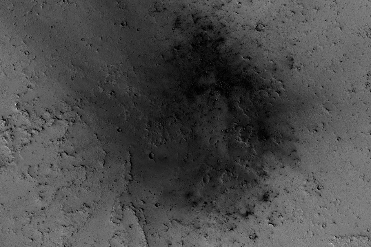
NASA's Mars Reconnaissance Orbiter has been observing Mars in sharp detail for more than a decade, enabling it to document many types of changes, such as the way winds alter the appearance of this recent impact site. The space-rock impact that created this blast zone occurred sometime between September 2005 and February 2006, as bracketed by observations made with the Mars Orbiter Camera on NASA's Mars Global Surveyor spacecraft. The location is between two large volcanos, named Ascraeus Mons and Pavonis Mons, in a dusty area of the Tharsis region of Mars. During the period from 2007 to 2012, winds blowing through the pass between the volcanoes darkened some regions and brightened others, probably by removing and depositing dust. The view covers an area about 1.0 mile (1.6 kilometers) across, at 7 degrees north latitude, 248 degrees east longitude. North is toward the top. An animation is availalble at http://photojournal.jpl.nasa.gov/catalog/PIA21267

CAPE CANAVERAL, Fla. – In the Granular Mechanics and Regolith Operations (GMRO) Lab at NASA's Kennedy Space Center in Florida, a piece of the Surveyor 3 spacecraft returned from the lunar surface on the Apollo 12 mission is available for examination by the lab's staff. The GMRO Lab is one of several labs located in NASA's Space Life Sciences Laboratory (SLSL) facility. The lab is staffed by three physicists, six mechanical or aerospace engineers and several technicians who are studying how the rocket exhaust of landing vehicles affects lunar and Martian science missions, including the sandblasting of instruments with soil and dust ejecta and the disturbance or contamination of soil beneath the lander. For more information on the GMRO Lab, see p. 7 of the Spaceport News dated Nov. 11, 2011, at http://www.nasa.gov/centers/kennedy/pdf/603285main_nov11-2011.pdf. Photo credit: NASA/Jim Grossmann
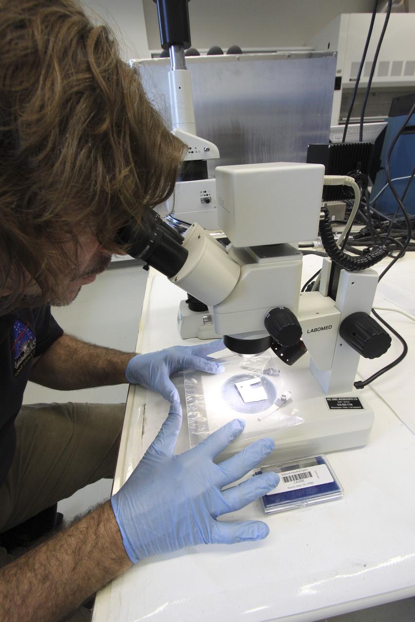
CAPE CANAVERAL, Fla. – In the Granular Mechanics and Regolith Operations (GMRO) Lab at NASA's Kennedy Space Center in Florida, Dr. Philip Metzger examines under a microscope a piece of the Surveyor 3 spacecraft returned from the lunar surface on the Apollo 12 mission. The GMRO Lab is one of several labs located in NASA's Space Life Sciences Laboratory (SLSL) facility. The lab is staffed by three physicists, six mechanical or aerospace engineers and several technicians who are studying how the rocket exhaust of landing vehicles affects lunar and Martian science missions, including the sandblasting of instruments with soil and dust ejecta and the disturbance or contamination of soil beneath the lander. For more information on the GMRO Lab, see p. 7 of the Spaceport News dated Nov. 11, 2011, at http://www.nasa.gov/centers/kennedy/pdf/603285main_nov11-2011.pdf. Photo credit: NASA/Jim Grossmann
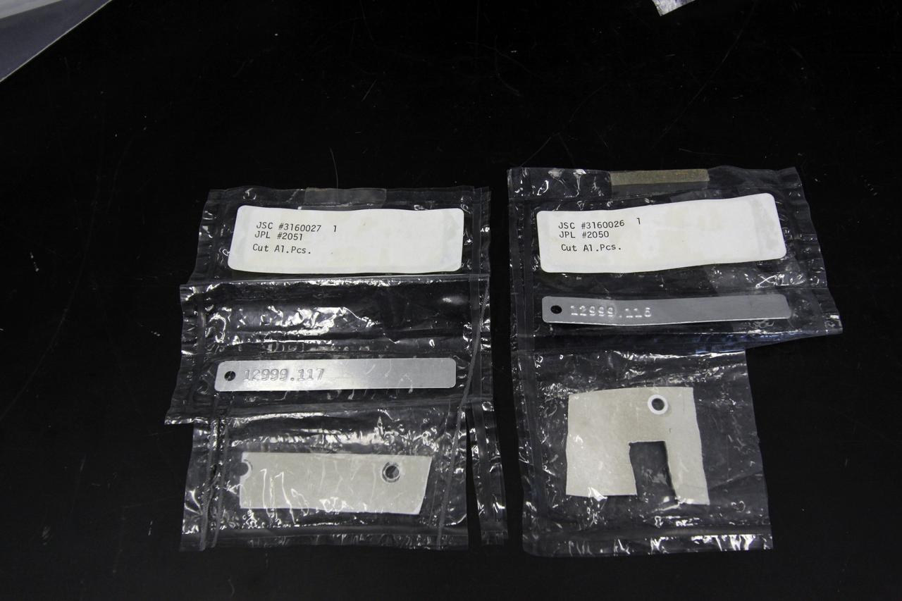
CAPE CANAVERAL, Fla. – In the Granular Mechanics and Regolith Operations (GMRO) Lab at NASA's Kennedy Space Center in Florida, pieces of the Surveyor 3 spacecraft returned from the lunar surface on the Apollo 12 mission are available for examination by the lab's staff. The GMRO Lab is one of several labs located in NASA's Space Life Sciences Laboratory (SLSL) facility. The lab is staffed by three physicists, six mechanical or aerospace engineers and several technicians who are studying how the rocket exhaust of landing vehicles affects lunar and Martian science missions, including the sandblasting of instruments with soil and dust ejecta and the disturbance or contamination of soil beneath the lander. For more information on the GMRO Lab, see p. 7 of the Spaceport News dated Nov. 11, 2011, at http://www.nasa.gov/centers/kennedy/pdf/603285main_nov11-2011.pdf. Photo credit: NASA/Jim Grossmann
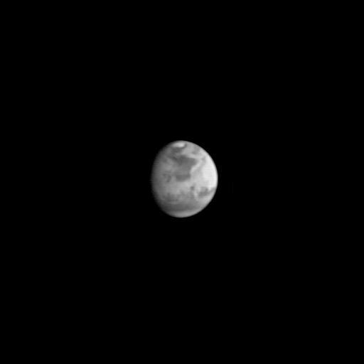
This image is the first view of Mars taken by the Mars Global Surveyor Orbiter Camera (MOC). It was acquired the afternoon of July 2, 1997 when the MGS spacecraft was 17.2 million kilometers (10.7 million miles) and 72 days from encounter. At this distance, the MOC's resolution is about 64 km per picture element, and the 6800 km (4200 mile) diameter planet is 105 pixels across. The observation was designed to show the Mars Pathfinder landing site at 19.4 N, 33.1 W approximately 48 hours prior to landing. The image shows the north polar cap of Mars at the top of the image, the dark feature Acidalia Planitia in the center with the brighter Chryse plain immediately beneath it, and the highland areas along the Martian equator including the canyons of the Valles Marineris (which are bright in this image owing to atmospheric dust). The dark features Terra Meridiani and Terra Sabaea can be seen at the 4 o`clock position, and the south polar hood (atmospheric fog and hazes) can be seen at the bottom of the image. Launched on November 7, 1996, Mars Global Surveyor will enter Mars orbit on Thursday, September 11 shortly after 6:00 PM PDT. After Mars Orbit Insertion, the spacecraft will use atmospheric drag to reduce the size of its orbit, achieving a circular orbit only 400 km (248 mi) above the surface in early March 1998, when mapping operations will begin. http://photojournal.jpl.nasa.gov/catalog/PIA00606
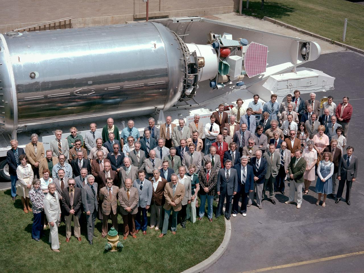
The National Aeronautics and Space Administration (NASA) Lewis Research Center’s Launch Vehicle Directorate in front of a full-scale model of the Centaur second-stage rocket. The photograph was taken to mark Centaur’s fiftieth launch. NASA Lewis managed the Centaur Program since 1962. At that time, the only prior launch attempt ended in failure. Lewis improved the spacecraft and tested it extensively throughout the early 1960s. In May 1966 an Atlas-Centaur sent the Surveyor spacecraft to the moon. It was the first successful soft landing on another planet. The Launch Vehicles Division was formed in 1969 to handle the increasing number of Centaur launches. The Lewis team became experts at integrating the payload with the Centaur and calculating proper trajectories for the missions. Centaur’s first 50 missions included Orbiting Astronomical Observatories, the Mariner 6 and 7 flybys of Mars, Mariner 9 which was the first spacecraft to orbit around another planet, the Pioneer 10 and 11 missions to the outer solar system, the Mariner 10 flyby of Venus and Mercury, the Viking 1 and 2 Mars landers, Voyagers 1 and 2 missions to Jupiter, Saturn, Uranus, and Neptune, and the Pioneer 12 and 13 flights to Venus.
This picture from Mars Pathfinder was taken at 9:30 AM in the martian morning (2:30 PM Pacific Daylight Time), after the spacecraft landed earlier today (July 4, 1997). The Sojourner rover is perched on one of three solar panels. The rover is 65 cm (26 inches) long by 18 cm (7 inches) tall; each of its wheels is about 13 cm (5 inches) high. The white material to the left of the front of the rover is part of the airbag system used to cushion the landing. Many rocks of different of different sizes can be seen, set in a background of reddish soil. The landing site is in the mouth of an ancient channel carved by water. The rocks may be primarily flood debris. The horizon is seen towards the top of the picture. The light brown hue of the sky results from suspended dust. Pathfinder, a low-cost Discovery mission, is the first of a new fleet of spacecraft that are planned to explore Mars over the next ten years. Mars Global Surveyor, already en route, arrives at Mars on September 11 to begin a two year orbital reconnaissance of the planet's composition, topography, and climate. Additional orbiters and landers will follow every 26 months. http://photojournal.jpl.nasa.gov/catalog/PIA00608
This false-color infrared image was taken by the camera system on the Mars Odyssey spacecraft over part of Ganges Chasma in Valles Marineris (approximately 13 degrees S, 318 degrees E). The infrared image has been draped over topography data obtained by Mars Global Surveyor. The color differences in this image show compositional variations in the rocks exposed in the wall and floor of Ganges (blue and purple) and in the dust and sand on the rim of the canyon (red and orange). The floor of Ganges is covered by rocks and sand composed of basaltic lava that are shown in blue. A layer that is rich in the mineral olivine can be seen as a band of purple in the walls on both sides of the canyon, and is exposed as an eroded layer surrounding a knob on the floor. Olivine is easily destroyed by liquid water, so its presence in these ancient rocks suggests that this region of Mars has been very dry for a very long time. The mosaic was constructed using infrared bands 5, 7, and 8, and covers an area approximately 150 kilometers (90 miles) on each side. This simulated view is toward the north. http://photojournal.jpl.nasa.gov/catalog/PIA04262
As we head into the 21st Century, it seems hard to believe that human beings have been sending spacecraft toward Mars for more than 3 decades already. The first spacecraft to reach Mars was Mariner 4 in 1965. This success was followed by two spacecraft in 1969, Mariners 6 and 7. Now the wonders and alien beauty of Mars continue to unfold with each day that the Mars Global Surveyor -- which arrived in September 1997 -- continues to radio its data to Earth. Mars exploration was always difficult and each bit of data returned from the planet is a marvel. On August 5, 1969, the Mariner 7 spacecraft flew past Mars at a minimum altitude of about 4200 km. It acquired 14 wide/narrow angle image pairs during the few minutes of the "near encounter" flyby. One of these image pairs, 7N19/7N20, shows the south polar region and contains a feature that at the time was nicknamed "the Giant's Footprint." Shown in the first two pictures, above, the feature consists of two adjoining craters, one about 80 km (50 mi) in diameter and the other about 50 km (31 mi) across near latitude 76°S, longitude 276°W. The oblique geometry of the Mariner 7 image enhances the impression of a footprint. The "Giant's Footprint" was almost missed when Mariner 7 suffered a near-catastrophic battery failure just a few days before the encounter -- on July 30 -- that put the spacecraft sporadically out of contact with Earth for two days. Ground controllers at the Jet Propulsion Laboratory (JPL)recovered the spacecraft, re-planned its imaging sequence based on results from the Mariner 6 flyby on July 31, and salvaged all of the mission's science goals in under a week! In the 1970's, the larger crater in "giant's footprint" was named "Vishniac" in honor of Wolf Vishniac, an American microbiologist of the University of Rochester who was instrumental in the development of methods to search for life on Mars. Vishniac was tragically killed in a fall in Antarctica in 1973 while retrieving a life detection experiment, and the crater was named in honor of this "giant" in the search for life on Mars. More than three decades after the Mariner 7 flyby, Mars Global Surveyor's Mars Orbiter Camera (MOC) acquired a commemorative view of the interior of Vishniac Crater on October 25, 1999. The context image and the 3-meters (9.8 feet)-per-pixel narrow angle view are shown above (in the lower image pair). Mariner 7's 7N20 has a nominal resolution of about 180 meters (591 feet) per pixel, while the MOC high resolution view is about 60 times higher (in actuality, the lower quality of the Mariner 7 images makes the resolution gain even more dramatic). The MOC high resolution view (lower right, above) shows a 1.5 kilometer-(0.9 mile)-wide portion of the floor of Vishniac in the process of defrosting during southern spring. The bright areas are still frost-covered, while the darker areas are either defrosted or composed of darkened or "dirty" frost. The dark patches in the image seem to serve as sources for dark streaks of material that has either been blown across the landscape by wind, or has somehow caused the erosion of frost to create the streaks. Dark streaks follow the local topography, as might the wind that blew across this landscape. This pattern of spots and streaks was quite common on the defrosting south polar cap during the spring that lasted from early August 1999 to late December 1999. All images shown here are illuminated by sunlight from the lower right. Image orientation with north toward the bottom was selected in order to show the "footprint" visible in Mariner 7 image 7N20. The Mariner 7 images were recovered at Malin Space Science Systems from the original 7-track magnetic tapes, archived on CD-ROM by the JPL Data Preservation activity. More images relating to the release can be viewed at http://photojournal.jpl.nasa.gov/catalog/PIA02365
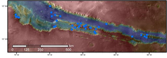
Blue dots on this map indicate sites of recurring slope lineae (RSL) in part of the Valles Marineris canyon network on Mars. RSL are seasonal dark streaks regarded as the strongest evidence for the possibility of liquid water on the surface of modern Mars. The area mapped here has the highest density of known RSL on the Red Planet. The RSL were identified by repeated observations of the sites using the High Resolution Imaging Science Experiment (HiRISE) camera on NASA's Mars Reconnaissance Orbiter. Map colors represent elevation, where red is high and blue is low. Valles Marineris is the largest canyon system in the solar system. The region shown here includes Melas Chasma and Coprates Chasma, in the central and eastern portions of Valles Marineris. The mapped area extends about 1,500 miles (2,400 kilometers) east to west and about 280 miles (450 kilometers) north to south, at latitudes from 9 to 17 degrees south of Mars' equator. The base map uses data from the Mars Orbiter Camera and Mars Orbiter Laser Altimeter of NASA's Mars Global Surveyor mission. RSL extend downslope during a warm season, fade in the colder part of the year, and repeat the process in a subsequent Martian year. A study of 41 RSL sites in this canyon area, published July 7, 2016, provides support for the notion that significant amounts of near-surface water can be found on modern Mars, though the work also indicates that puzzles remain unsolved in understanding how these seasonal features form. Each site includes anywhere from a few to more than 1,000 individual "lineae." http://photojournal.jpl.nasa.gov/catalog/PIA20756
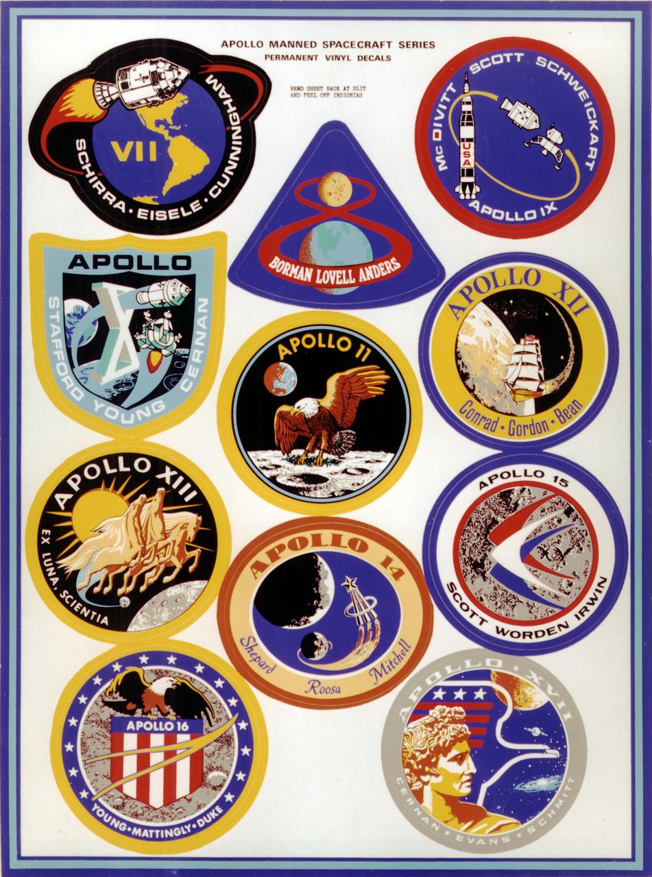
This montage depicts the flight crew patches for the manned Apollo 7 thru Apollo 17 missions. The Apollo 7 through 10 missions were basically manned test flights that paved the way for lunar landing missions. Primary objectives met included the demonstration of the Command Service Module (CSM) crew performance; crew/space vehicle/mission support facilities performance and testing during a manned CSM mission; CSM rendezvous capability; translunar injection demonstration; the first manned Apollo docking, the first Apollo Extra Vehicular Activity (EVA), performance of the first manned flight of the lunar module (LM); the CSM-LM docking in translunar trajectory, LM undocking in lunar orbit, LM staging in lunar orbit, and manned LM-CSM docking in lunar orbit. Apollo 11 through 17 were lunar landing missions with the exception of Apollo 13 which was forced to circle the moon without landing due to an onboard explosion. The craft was,however, able to return to Earth safely. Apollo 11 was the first manned lunar landing mission and performed the first lunar surface EVA. Landing site was the Sea of Tranquility. A message for mankind was delivered, the U.S. flag was planted, experiments were set up and 47 pounds of lunar surface material was collected for analysis back on Earth. Apollo 12, the 2nd manned lunar landing mission landed in the Ocean of Storms and retrieved parts of the unmanned Surveyor 3, which had landed on the Moon in April 1967. The Apollo Lunar Surface Experiments Package (ALSEP) was deployed, and 75 pounds of lunar material was gathered. Apollo 14, the 3rd lunar landing mission landed in Fra Mauro. ALSEP and other instruments were deployed, and 94 pounds of lunar materials were gathered, using a hand cart for first time to transport rocks. Apollo 15, the 4th lunar landing mission landed in the Hadley-Apennine region. With the first use of the Lunar Roving Vehicle (LRV), the crew was bale to gather 169 pounds of lunar material. Apollo 16, the 5th lunar landing mission, landed in the Descartes Highlands for the first study of highlands area. Selected surface experiments were deployed, the ultraviolet camera/spectrograph was used for first time on the Moon, and the LRV was used for second time for a collection of 213 pounds of lunar material. The Apollo program came to a close with Apollo 17, the 6th and final manned lunar landing mission that landed in the Taurus-Littrow highlands and valley area. This mission hosted the first scientist-astronaut, Schmitt, to land on the Moon. The 6th automated research station was set up, and 243 ponds of lunar material was gathered using the LRV.