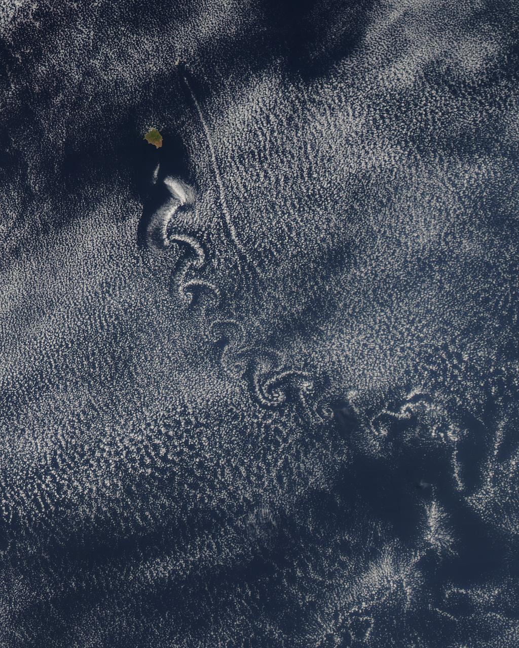
Theodore von Kármán, a Hungarian-American physicist, was the first to describe the physical processes that create long chains of spiral eddies like the one shown above. Known as von Kármán vortices the patterns can form nearly anywhere that fluid flow is disturbed by an object. Since the atmosphere behaves like a fluid, the wing of an airplane, a bridge, even an island can trigger the distinctive phenomenon. On May 22, 2013, the Moderate Resolution Imaging Spectroradiometer (MODIS) on NASA’s Terra satellite captured this natural-color image of cloud vortices behind Isla Socorro, a volcanic island located in the Pacific Ocean. The island, which is located a few hundred kilometers off the west coast of Mexico and the southern tip of Baja California, is part of the Revillagigedo Archipelago. Satellite sensors have spotted von Kármán vortices around the globe, including off of Guadalupe Island, near the coast of Chile, in the Greenland Sea, in the Arctic, and even next to a tropical storm. NASA image courtesy Jeff Schmaltz, LANCE/EOSDIS MODIS Rapid Response Team at NASA GSFC. Caption by Adam Voiland. Instrument: Terra - MODIS More info: <a href="http://1.usa.gov/14VSDQa" rel="nofollow">1.usa.gov/14VSDQa</a> Credit: <b><a href="http://www.earthobservatory.nasa.gov/" rel="nofollow"> NASA Earth Observatory</a></b> <b><a href="http://www.nasa.gov/audience/formedia/features/MP_Photo_Guidelines.html" rel="nofollow">NASA image use policy.</a></b> <b><a href="http://www.nasa.gov/centers/goddard/home/index.html" rel="nofollow">NASA Goddard Space Flight Center</a></b> enables NASA’s mission through four scientific endeavors: Earth Science, Heliophysics, Solar System Exploration, and Astrophysics. Goddard plays a leading role in NASA’s accomplishments by contributing compelling scientific knowledge to advance the Agency’s mission. <b>Follow us on <a href="http://twitter.com/NASA_GoddardPix" rel="nofollow">Twitter</a></b> <b>Like us on <a href="http://www.facebook.com/pages/Greenbelt-MD/NASA-Goddard/395013845897?ref=tsd" rel="nofollow">Facebook</a></b> <b>Find us on <a href="http://instagram.com/nasagoddard?vm=grid" rel="nofollow">Instagram</a></b>
NASA image captured April 12, 2011 at 1731 UTC (1:31 p.m. EDT) A giant swirl of clouds that form an apostrophe-like shape over the eastern U.S. was spotted in visible imagery from the Geostationary Operational Environmental Satellite, GOES-13 on April 12, 2011 at 1731 UTC (1:31 p.m. EDT). The GOES-13 satellite monitors weather over the eastern continental U.S. and Atlantic Ocean, while GOES-11 monitors the western U.S. and the Eastern Pacific Ocean. GOES-13 captured this image of the clouds associated with a strong upper level low pressure area that is moving though the Tennessee River Valley and bringing moderate to heavy rainfall as it moves eastward. The low is forecast by the National Weather Service to bring unsettled conditions to the Mid-Atlantic and then to New England late Tuesday and Wednesday as it tracks northeast. Severe thunderstorms are possible today in extreme eastern Virginia and North Carolina as the cold front associated with the low pushes through that region. Meanwhile, rainfall from the low stretches from Massachusetts south to Florida today. It seems that New Englanders are having a tough time getting warm spring weather and this low won't help as it moves north. The low pressure area may even bring some light to moderate snowfall on the northern fringe of the storm. The GOES series of satellites keep an eye on the weather happening over the continental U.S. and eastern Pacific and Atlantic Oceans. NASA's GOES Project, located at NASA's Goddard Space Flight Center in Greenbelt, Md., procures and manages the development and launch of the GOES series of satellites for NOAA and creates images and animations. The GOES satellites are operated by NOAA. Rob Gutro NASA's Goddard Space Flight Center <b><a href="http://goes.gsfc.nasa.gov/" rel="nofollow">Credit: NOAA/NASA GOES Project</a></b> <b><a href="http://www.nasa.gov/centers/goddard/home/index.html" rel="nofollow">NASA Goddard Space Flight Center</a></b> enables NASA’s mission through four scientific endeavors: Earth Science, Heliophysics, Solar System Exploration, and Astrophysics. Goddard plays a leading role in NASA’s accomplishments by contributing compelling scientific knowledge to advance the Agency’s mission. <b>Follow us on <a href="http://twitter.com/NASA_GoddardPix" rel="nofollow">Twitter</a></b> <b>Join us on <a href="http://www.facebook.com/pages/Greenbelt-MD/NASA-Goddard/395013845897?ref=tsd" rel="nofollow">Facebook</a></b>
![A swirling Eastern Pacific Ocean storm system headed for California was spotted by NOAA's GOES-West satellite on February 28. According to the National Weather Service, this storm system has the potential to bring heavy rainfall to the drought-stricken state. The storm was captured using visible data from NOAA's GOES-West or GOES-15 satellite on Feb. 28 at 1915 UTC/11:15 a.m. PST was made into an image by NASA/NOAA's GOES Project at NASA's Goddard Space Flight Center in Greenbelt, Md. The storm's center appeared as a tight swirl, with bands of clouds and showers already sweeping over the state extending from northern California to Baja California, Mexico. At 11:30 a.m. PST on February 28, Bill Patzert, climatologist at NASA's Jet Propulsion Laboratory in Pasadena, Calif. said, "Right now from northern to southern California we are being battered by very heavy rain, strong winds and our coastal communities are being battered by high surf. Through the weekend we are bracing for mud and rock slides in areas that recently burned [from wildfires]. Flooding is looming up and down the state." The National Weather Service (NWS) serving Los Angeles posted a Flood Watch for the region on Friday, February 28. The Flood Watch notes the "potential for flash flooding and debris flows for some 2013 and 2014 burn areas in Los Angeles County from this morning through Saturday evening (March 1).” The NWS Flood Watch also noted "a very strong and dynamic storm will bring a significant amount of rain to much of southwestern California through Saturday evening. A flash flood watch has been issued for several recent burn areas in Los Angeles County due to the abundant rainfall expected. Rain rates at times are expected to range from a half inch to one inch per hour which could cause significant mud and debris flows. There will be a chance of thunderstorms with locally higher rainfall rates." "Californians haven't seen rain and wind this powerful in 3 years," Patzert said. "By early next week, as this system moves east, this powerful system will wreak havoc causing snow and ice storms through the Midwest into the Northeast." GOES satellites provide the kind of continuous monitoring necessary for intensive data analysis. Geostationary describes an orbit in which a satellite is always in the same position with respect to the rotating Earth. This allows GOES to hover continuously over one position on Earth's surface, appearing stationary. As a result, GOES provide a constant vigil for the atmospheric "triggers" for severe weather conditions such as tornadoes, flash floods, hail storms and hurricanes. On a positive note, Patzert noted, "This is a nice down payment on drought recovery in the parched Western U.S." For updated information about the storm system, visit NOAA's National Weather Service website: <a href="http://www.weather.gov" rel="nofollow">www.weather.gov</a> For more information about GOES satellites, visit: <a href="http://www.goes.noaa.gov/" rel="nofollow">www.goes.noaa.gov/</a> or <a href="http://goes.gsfc.nasa.gov/" rel="nofollow">goes.gsfc.nasa.gov/</a> Rob Gutro NASA's Goddard Space Flight Center <b><a href="http://www.nasa.gov/audience/formedia/features/MP_Photo_Guidelines.html" rel="nofollow">NASA image use policy.</a></b> <b><a href="http://www.nasa.gov/centers/goddard/home/index.html" rel="nofollow">NASA Goddard Space Flight Center</a></b> enables NASA’s mission through four scientific endeavors: Earth Science, Heliophysics, Solar System Exploration, and Astrophysics. Goddard plays a leading role in NASA’s accomplishments by contributing compelling scientific knowledge to advance the Agency’s mission. <b>Follow us on <a href="http://twitter.com/NASAGoddardPix" rel="nofollow">Twitter</a></b> <b>Like us on <a href="http://www.facebook.com/pages/Greenbelt-MD/NASA-Goddard/395013845897?ref=tsd" rel="nofollow">Facebook</a></b> <b>Find us on <a href="http://instagram.com/nasagoddard?vm=grid" rel="nofollow">Instagram</a></b>](https://images-assets.nasa.gov/image/GSFC_20171208_Archive_e001192/GSFC_20171208_Archive_e001192~medium.jpg)
A swirling Eastern Pacific Ocean storm system headed for California was spotted by NOAA's GOES-West satellite on February 28. According to the National Weather Service, this storm system has the potential to bring heavy rainfall to the drought-stricken state. The storm was captured using visible data from NOAA's GOES-West or GOES-15 satellite on Feb. 28 at 1915 UTC/11:15 a.m. PST was made into an image by NASA/NOAA's GOES Project at NASA's Goddard Space Flight Center in Greenbelt, Md. The storm's center appeared as a tight swirl, with bands of clouds and showers already sweeping over the state extending from northern California to Baja California, Mexico. At 11:30 a.m. PST on February 28, Bill Patzert, climatologist at NASA's Jet Propulsion Laboratory in Pasadena, Calif. said, "Right now from northern to southern California we are being battered by very heavy rain, strong winds and our coastal communities are being battered by high surf. Through the weekend we are bracing for mud and rock slides in areas that recently burned [from wildfires]. Flooding is looming up and down the state." The National Weather Service (NWS) serving Los Angeles posted a Flood Watch for the region on Friday, February 28. The Flood Watch notes the "potential for flash flooding and debris flows for some 2013 and 2014 burn areas in Los Angeles County from this morning through Saturday evening (March 1).” The NWS Flood Watch also noted "a very strong and dynamic storm will bring a significant amount of rain to much of southwestern California through Saturday evening. A flash flood watch has been issued for several recent burn areas in Los Angeles County due to the abundant rainfall expected. Rain rates at times are expected to range from a half inch to one inch per hour which could cause significant mud and debris flows. There will be a chance of thunderstorms with locally higher rainfall rates." "Californians haven't seen rain and wind this powerful in 3 years," Patzert said. "By early next week, as this system moves east, this powerful system will wreak havoc causing snow and ice storms through the Midwest into the Northeast." GOES satellites provide the kind of continuous monitoring necessary for intensive data analysis. Geostationary describes an orbit in which a satellite is always in the same position with respect to the rotating Earth. This allows GOES to hover continuously over one position on Earth's surface, appearing stationary. As a result, GOES provide a constant vigil for the atmospheric "triggers" for severe weather conditions such as tornadoes, flash floods, hail storms and hurricanes. On a positive note, Patzert noted, "This is a nice down payment on drought recovery in the parched Western U.S." For updated information about the storm system, visit NOAA's National Weather Service website: <a href="http://www.weather.gov" rel="nofollow">www.weather.gov</a> For more information about GOES satellites, visit: <a href="http://www.goes.noaa.gov/" rel="nofollow">www.goes.noaa.gov/</a> or <a href="http://goes.gsfc.nasa.gov/" rel="nofollow">goes.gsfc.nasa.gov/</a> Rob Gutro NASA's Goddard Space Flight Center <b><a href="http://www.nasa.gov/audience/formedia/features/MP_Photo_Guidelines.html" rel="nofollow">NASA image use policy.</a></b> <b><a href="http://www.nasa.gov/centers/goddard/home/index.html" rel="nofollow">NASA Goddard Space Flight Center</a></b> enables NASA’s mission through four scientific endeavors: Earth Science, Heliophysics, Solar System Exploration, and Astrophysics. Goddard plays a leading role in NASA’s accomplishments by contributing compelling scientific knowledge to advance the Agency’s mission. <b>Follow us on <a href="http://twitter.com/NASAGoddardPix" rel="nofollow">Twitter</a></b> <b>Like us on <a href="http://www.facebook.com/pages/Greenbelt-MD/NASA-Goddard/395013845897?ref=tsd" rel="nofollow">Facebook</a></b> <b>Find us on <a href="http://instagram.com/nasagoddard?vm=grid" rel="nofollow">Instagram</a></b>