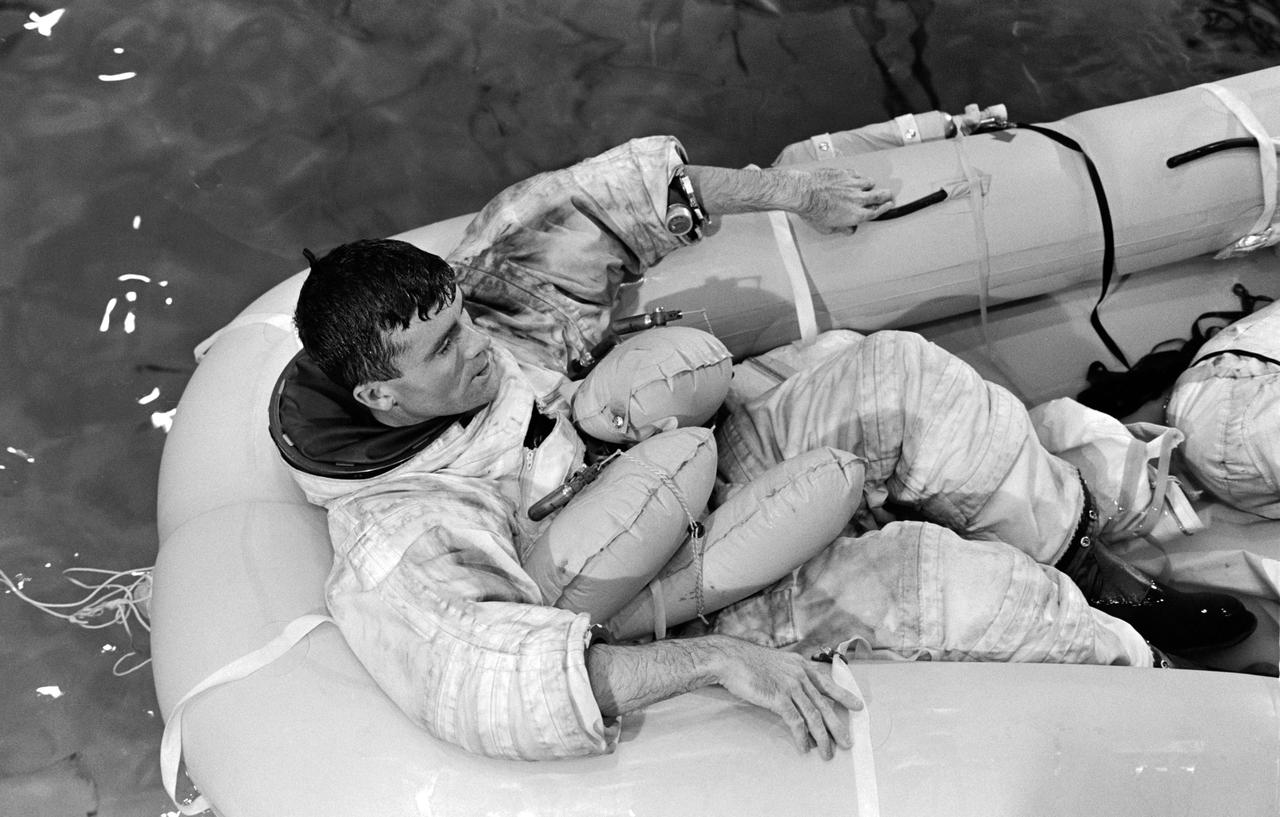
Boeing astronaut and CST-100 Starliner Crew Flight Test crew member Chris Ferguson trains for a contingency water landing in NASA’s Neutral Buoyancy Laboratory at the Johnson Space Center in Houston, Texas. Starliner is designed to land on land, but it can also abort to safe water landings if needed. For safety, all Starliner crews will prepare for all possible scenarios, however unlikely. Boeing’s Crew Flight Test is part of NASA’s Commercial Crew Program, which is working with Boeing to return human spaceflight launches to the space station from U.S. soil.
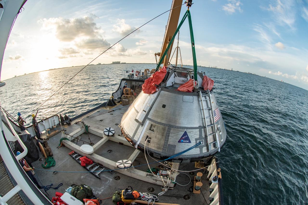
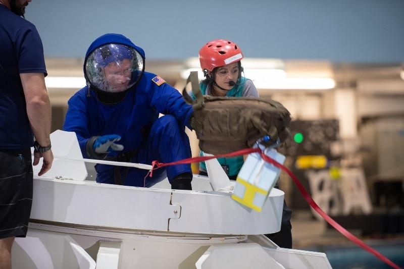
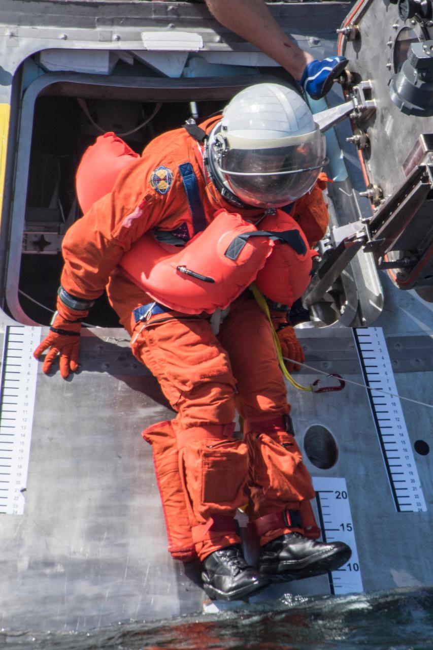
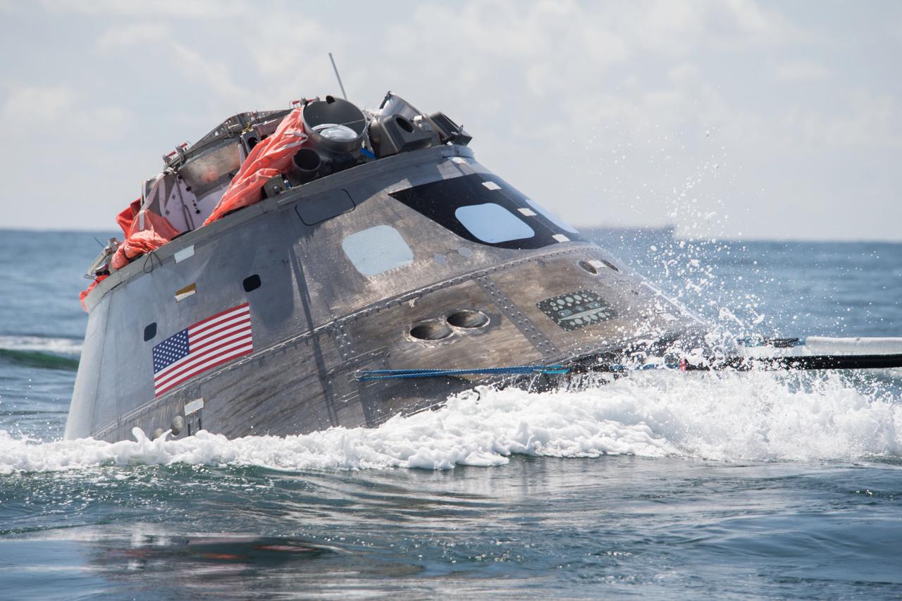
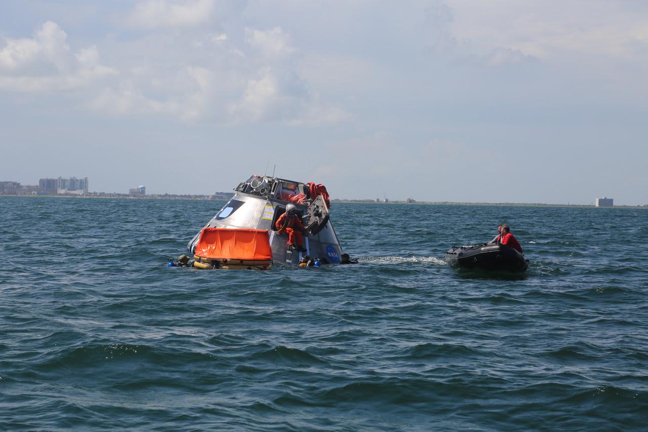
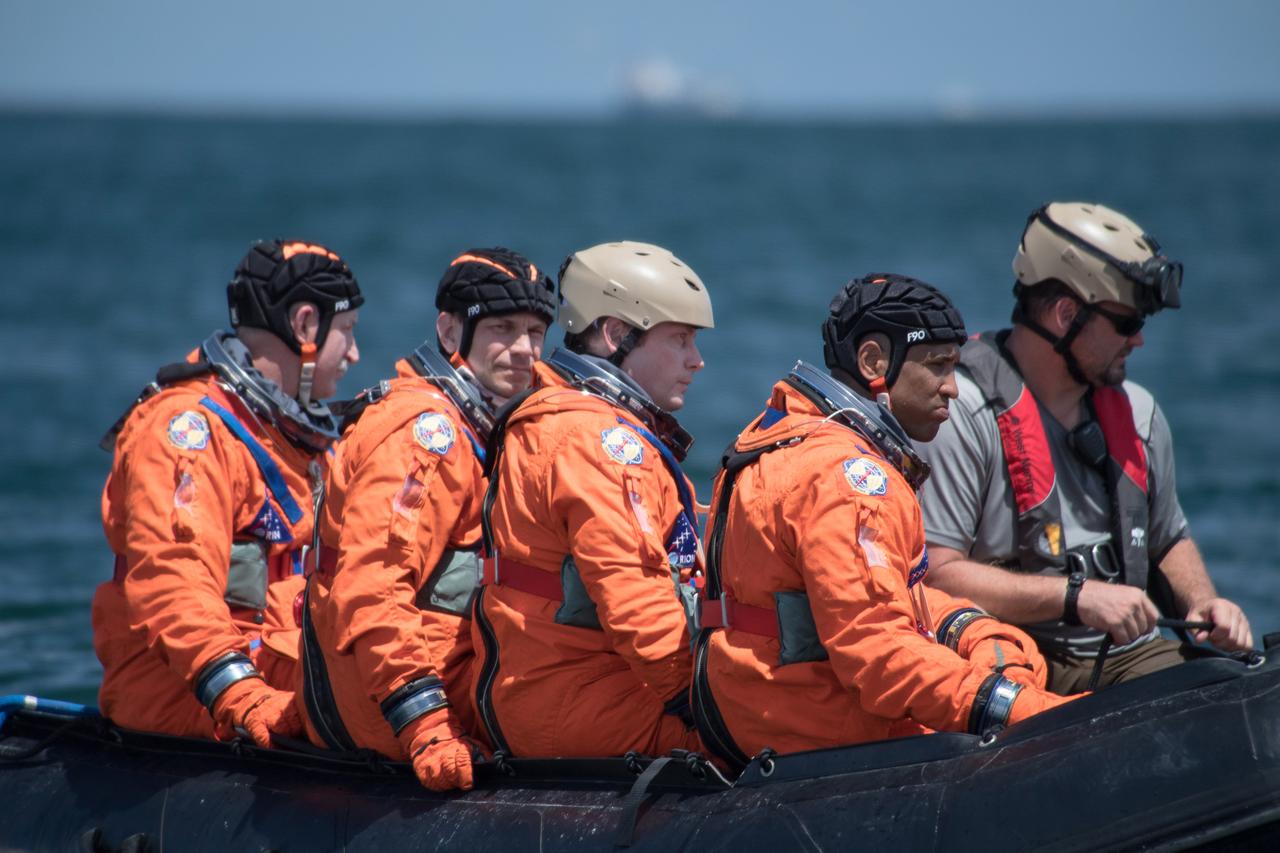
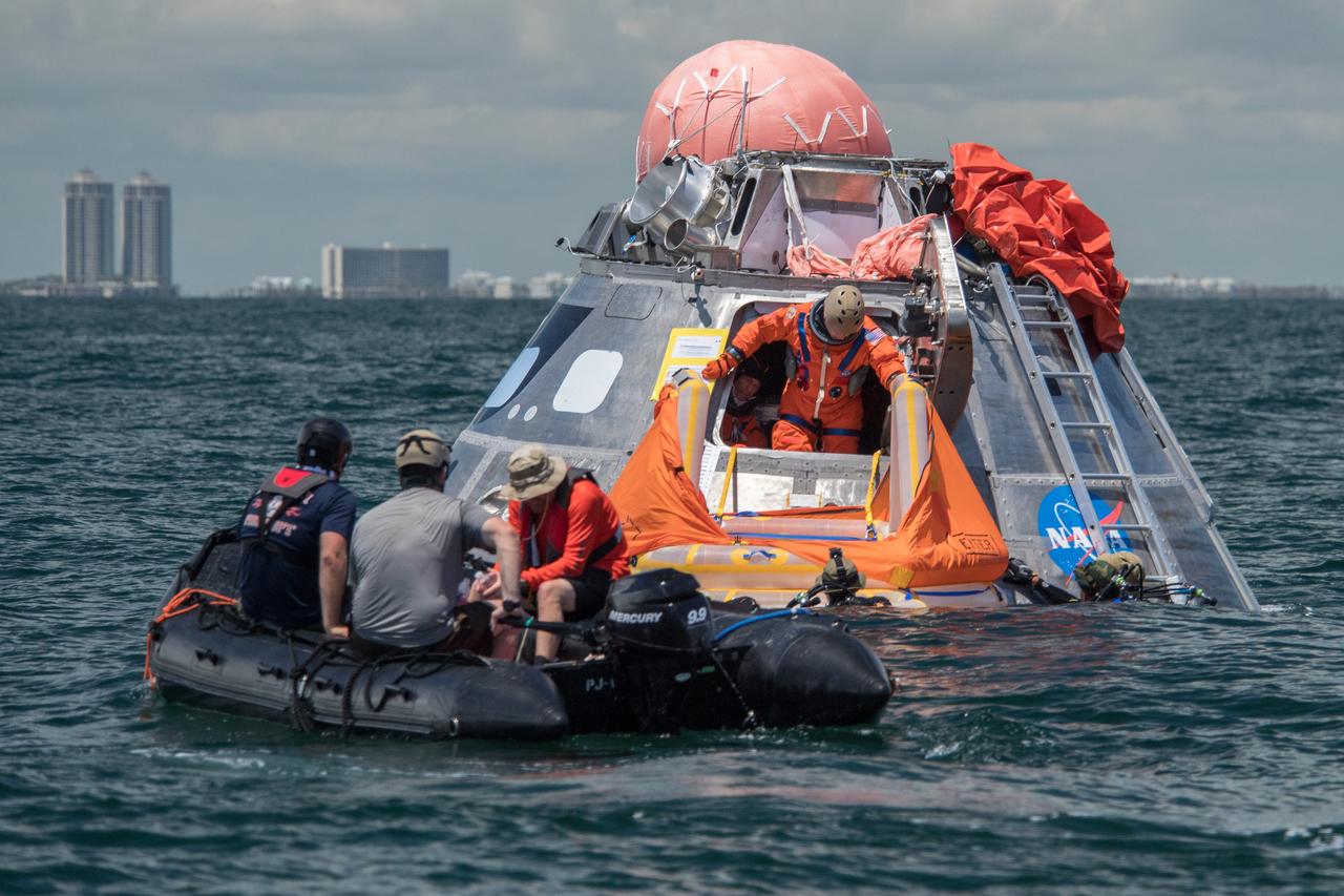
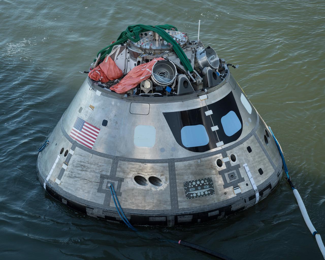
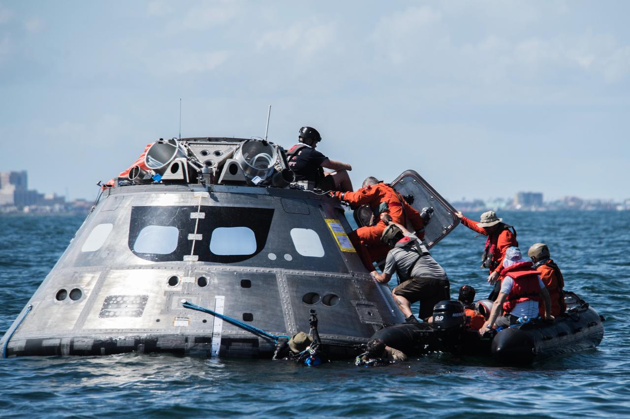
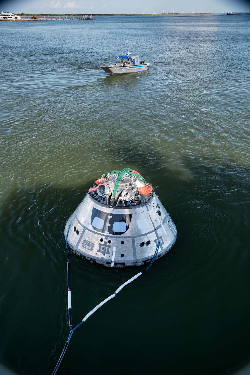
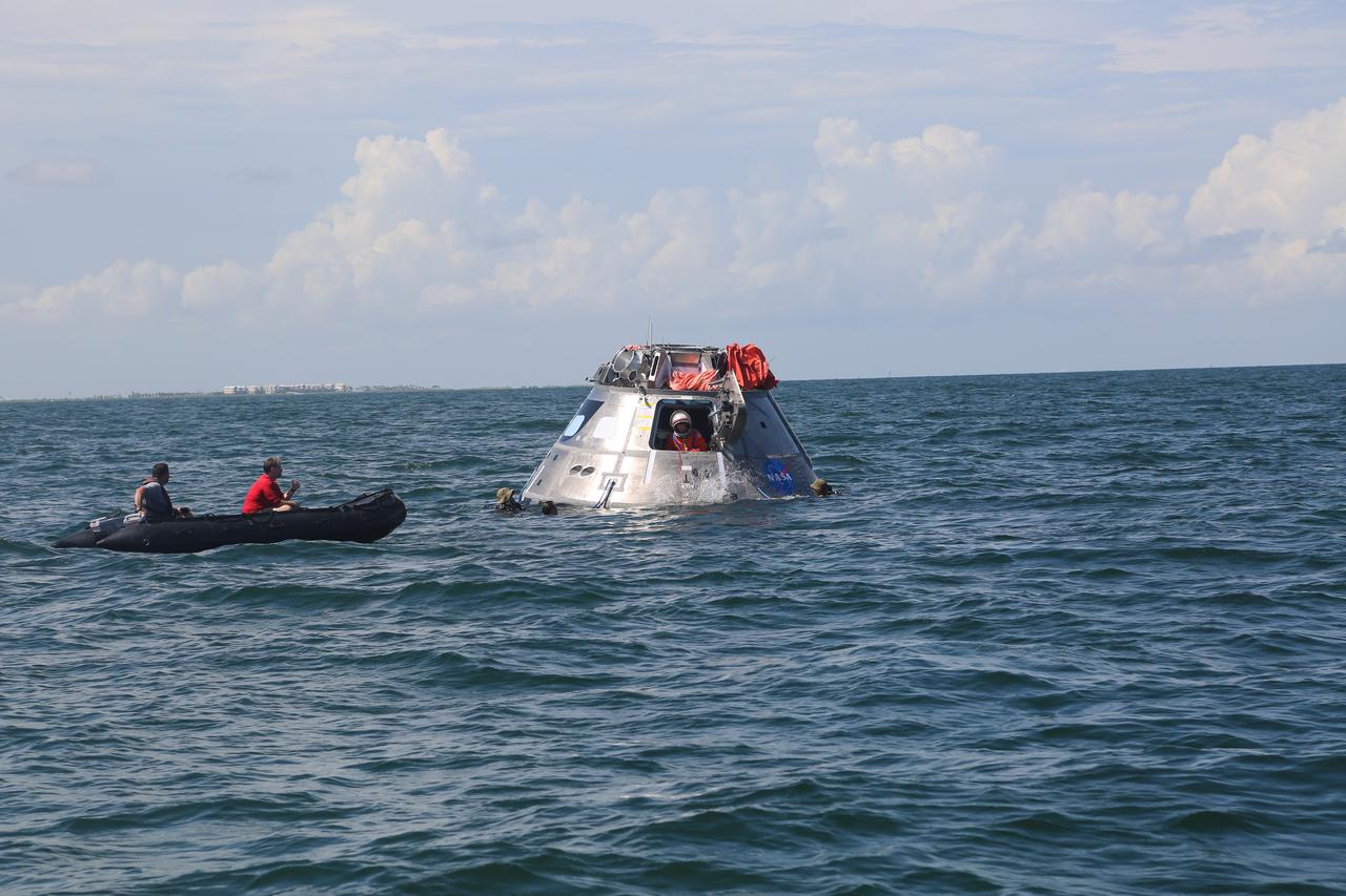
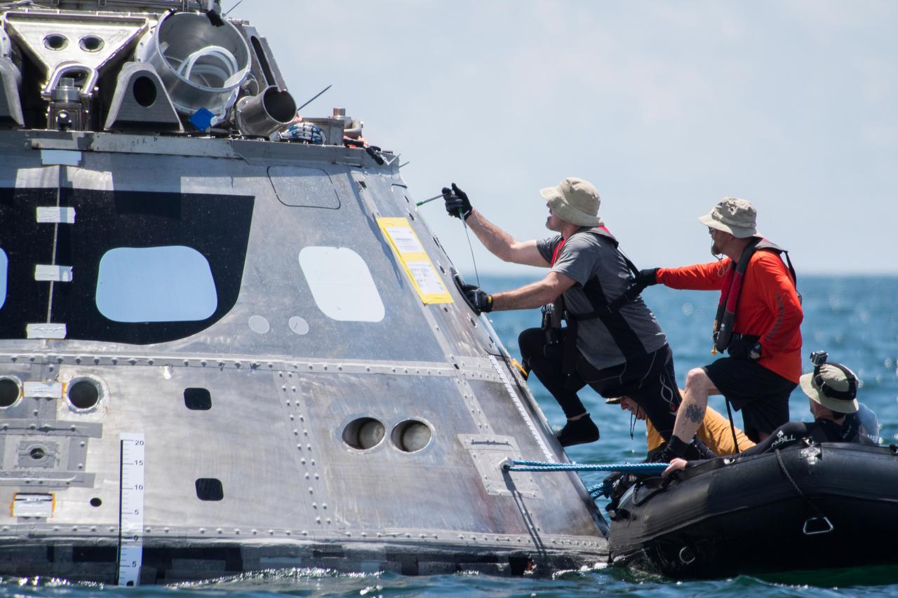
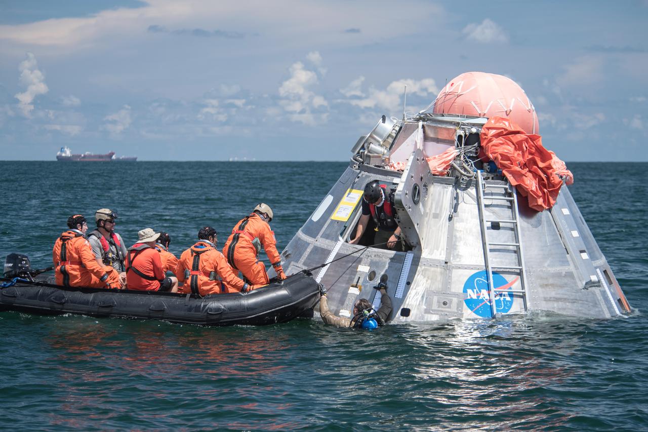
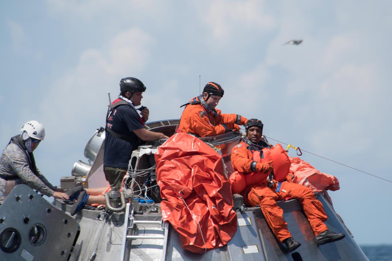
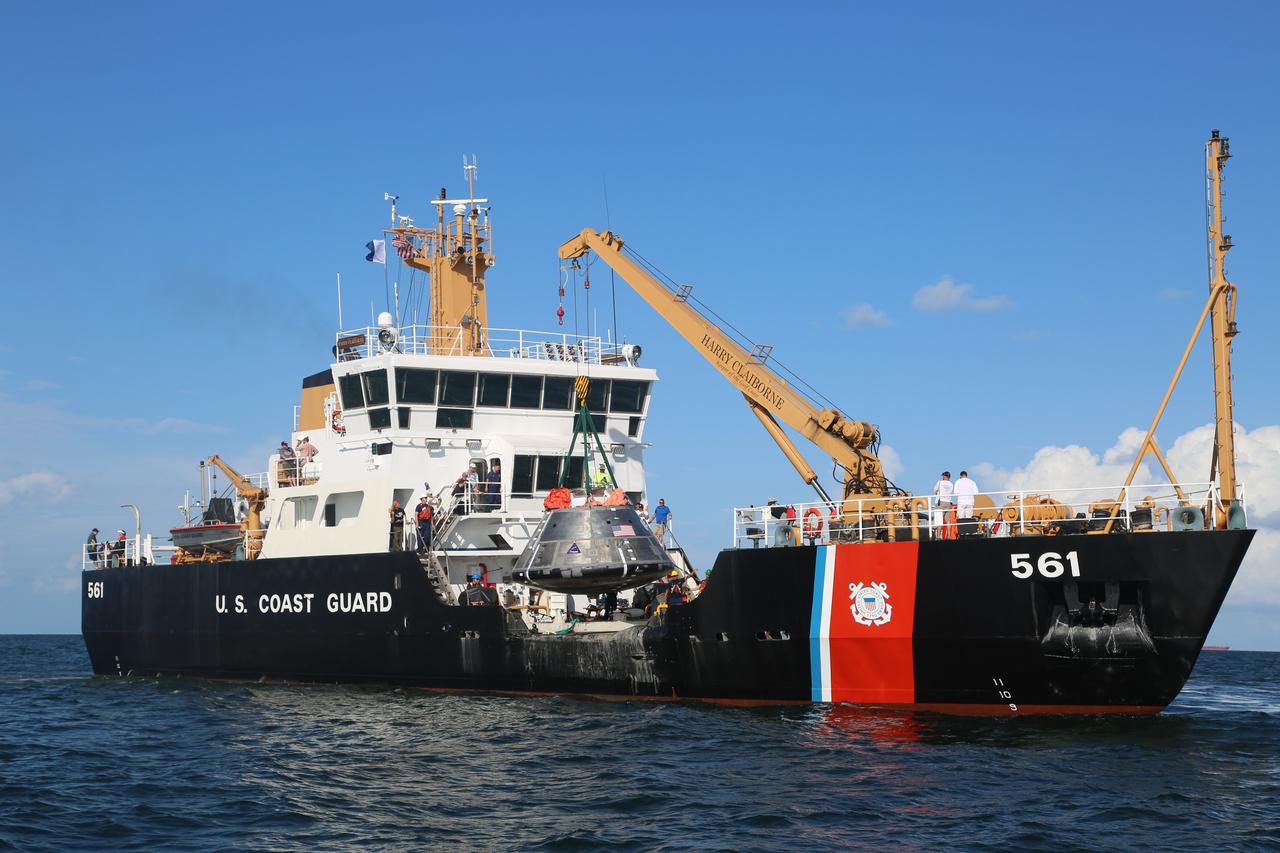
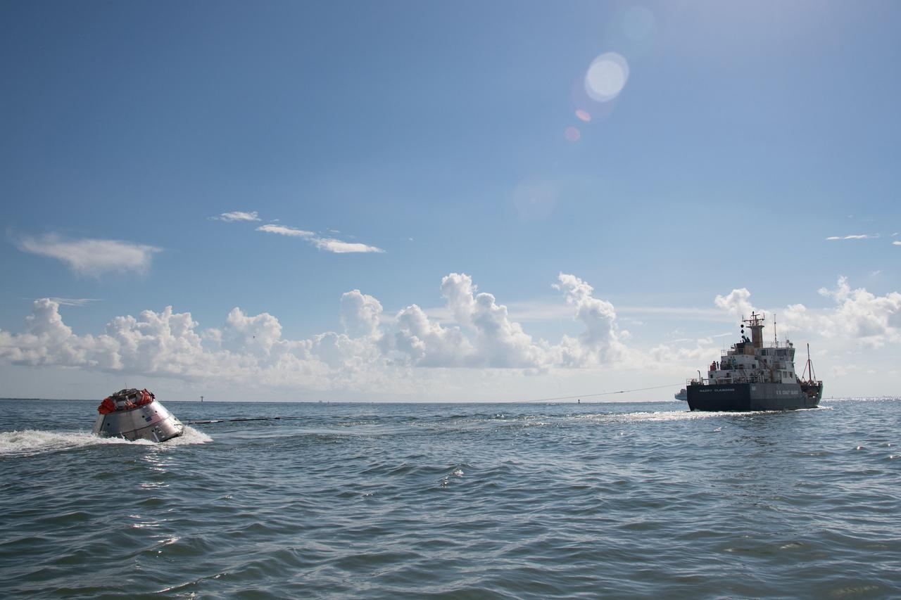
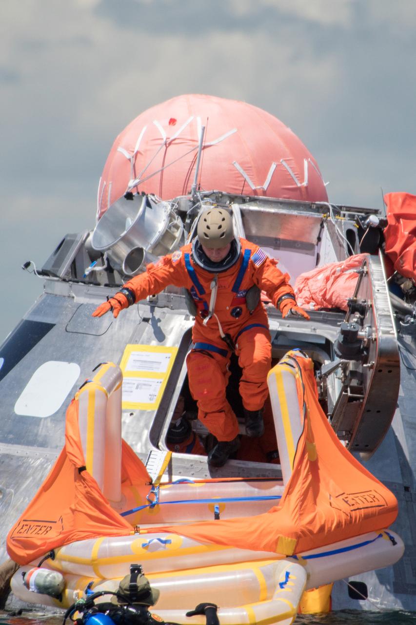
When astronauts return to Earth from destinations beyond the Moon in NASA’s Orion spacecraft and splashdown in the Pacific Ocean, they’ll still need to safely get out of the spacecraft and back on dry land. Using the waters off the coast of Galveston, Texas, a NASA and Department of Defense team test Orion exit procedures in a variety of scenarios on July 11, 2017. Part of Batch images transfer from Flickr.
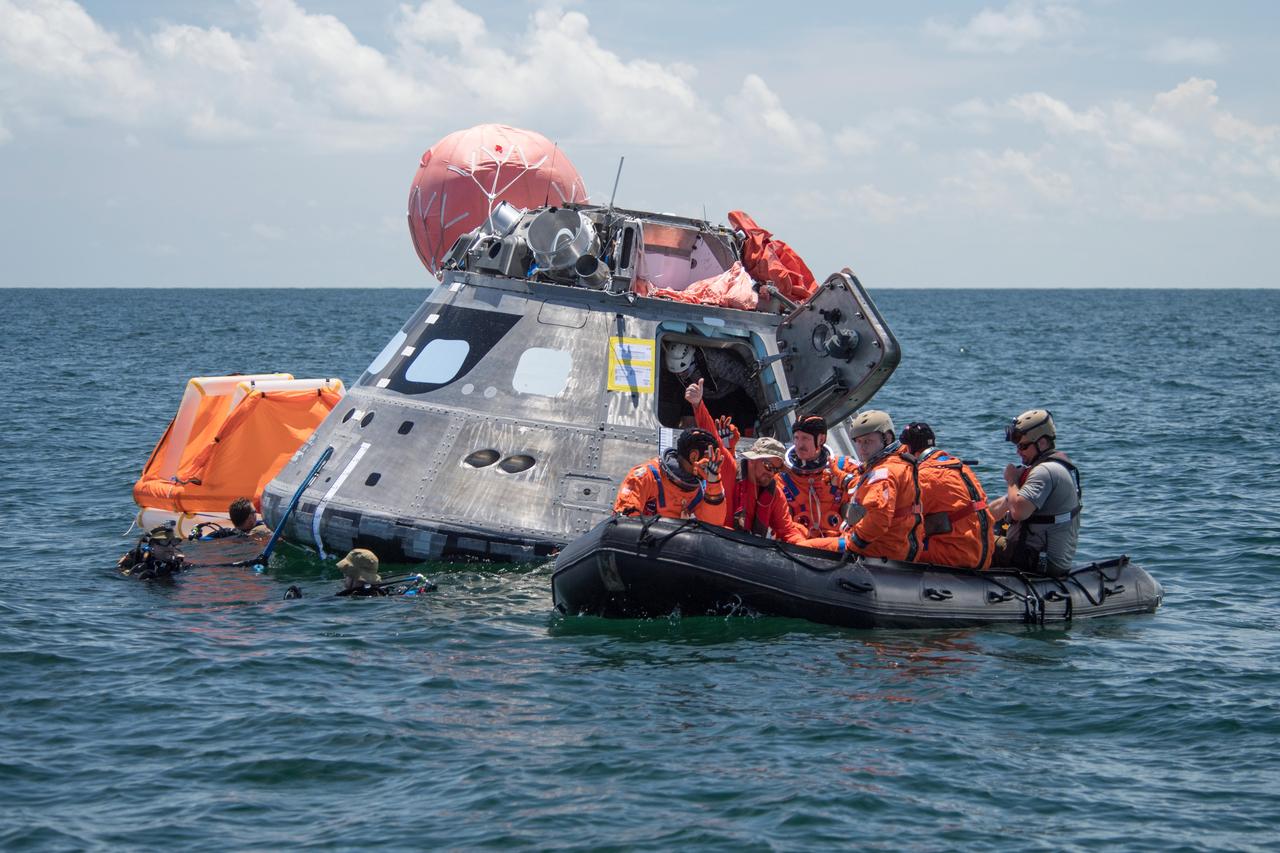
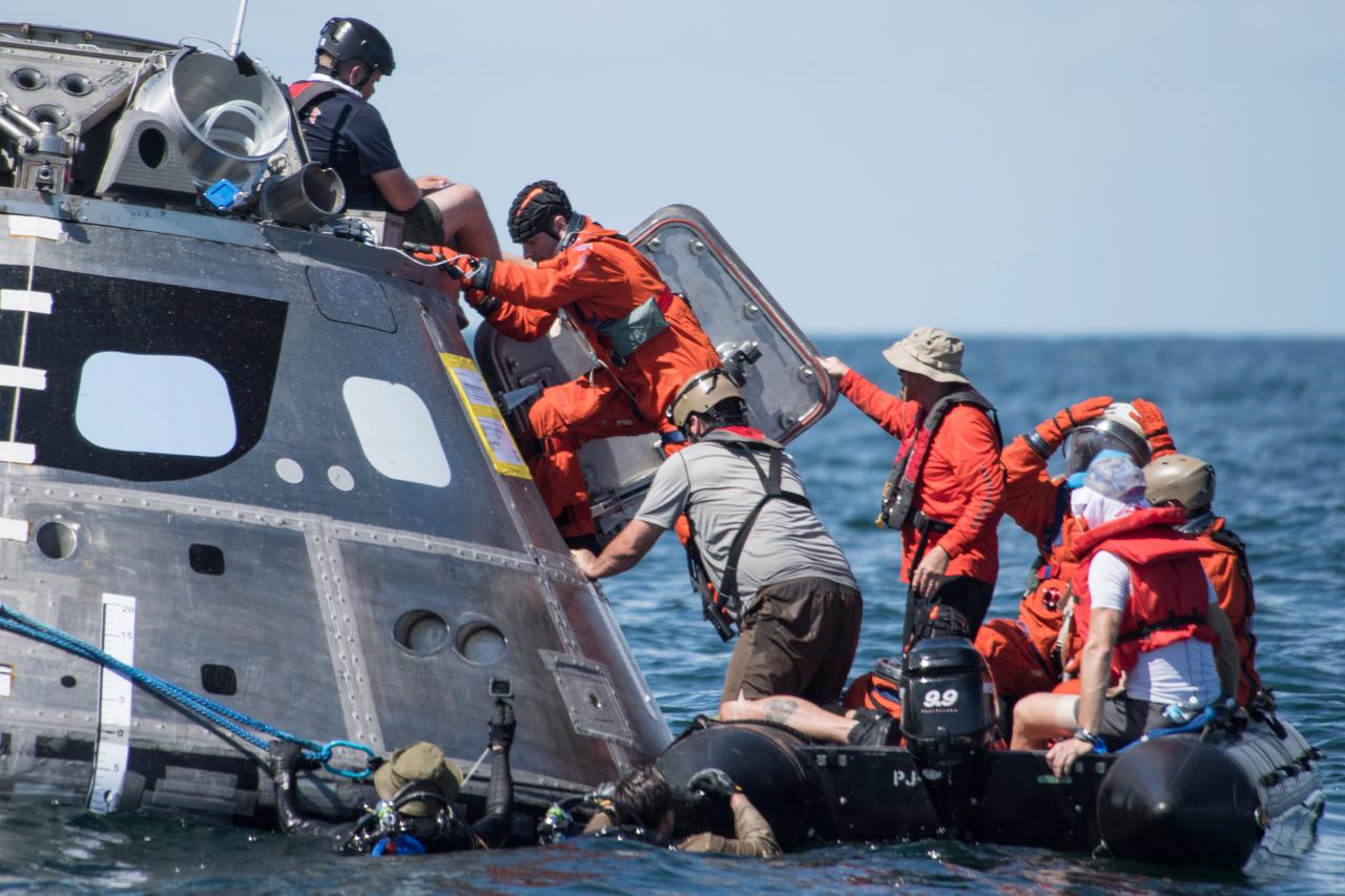
When astronauts return to Earth from destinations beyond the Moon in NASA’s Orion spacecraft and splashdown in the Pacific Ocean, they’ll still need to safely get out of the spacecraft and back on dry land. Using the waters off the coast of Galveston, Texas, a NASA and Department of Defense team test Orion exit procedures in a variety of scenarios on July 11, 2017. Part of Batch images transfer from Flickr.
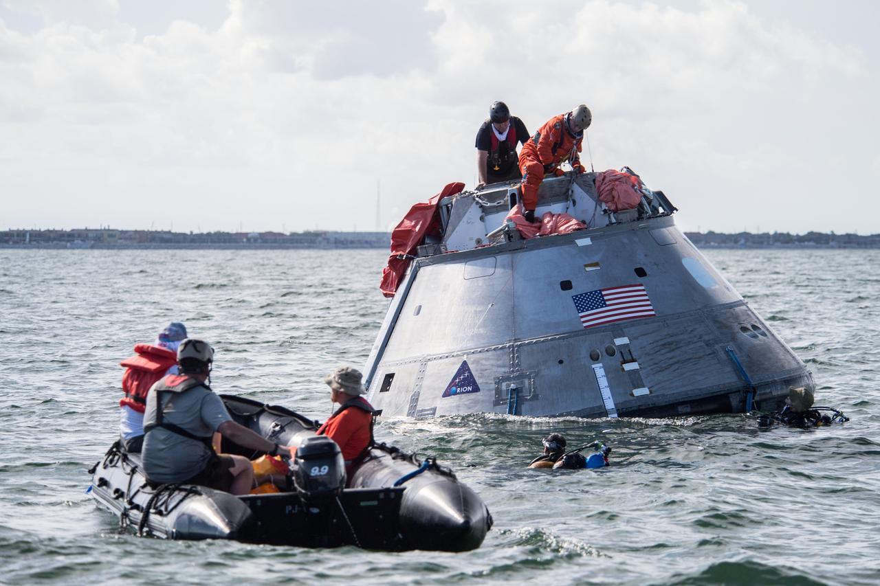
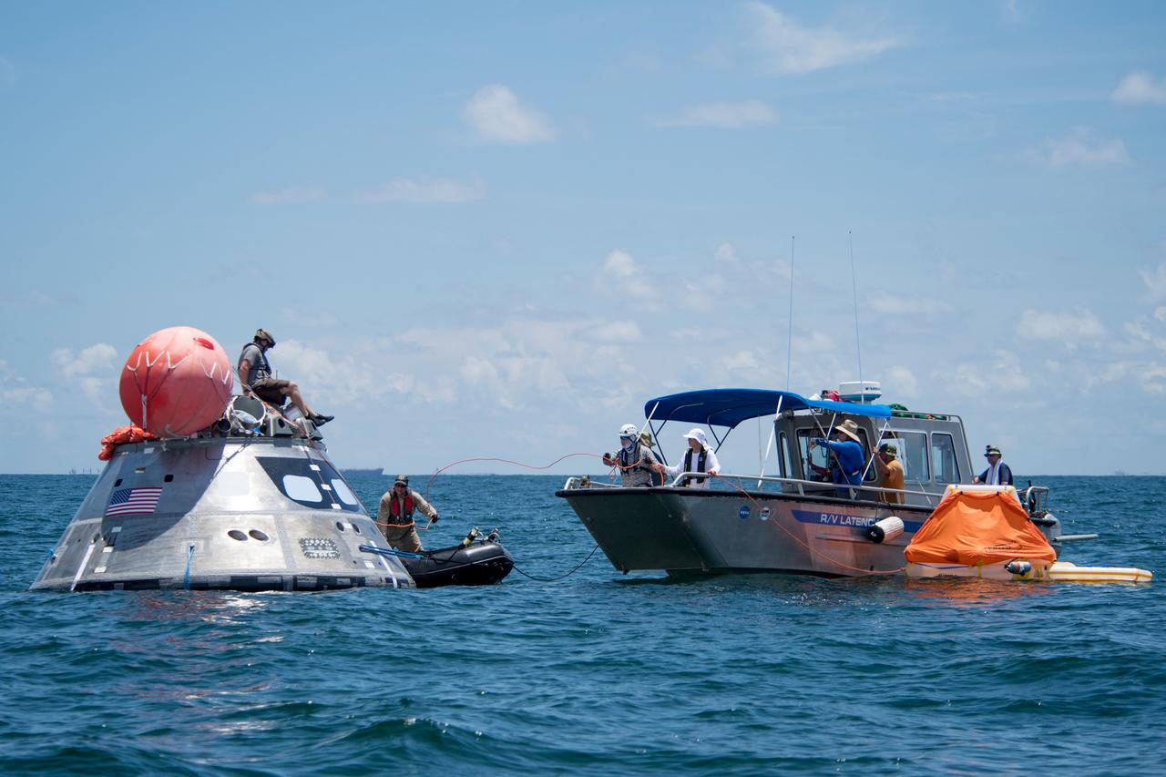
When astronauts return to Earth from destinations beyond the Moon in NASA’s Orion spacecraft and splashdown in the Pacific Ocean, they’ll still need to safely get out of the spacecraft and back on dry land. Using the waters off the coast of Galveston, Texas, a NASA and Department of Defense team test Orion exit procedures in a variety of scenarios on July 11, 2017. Part of Batch images transfer from Flickr.
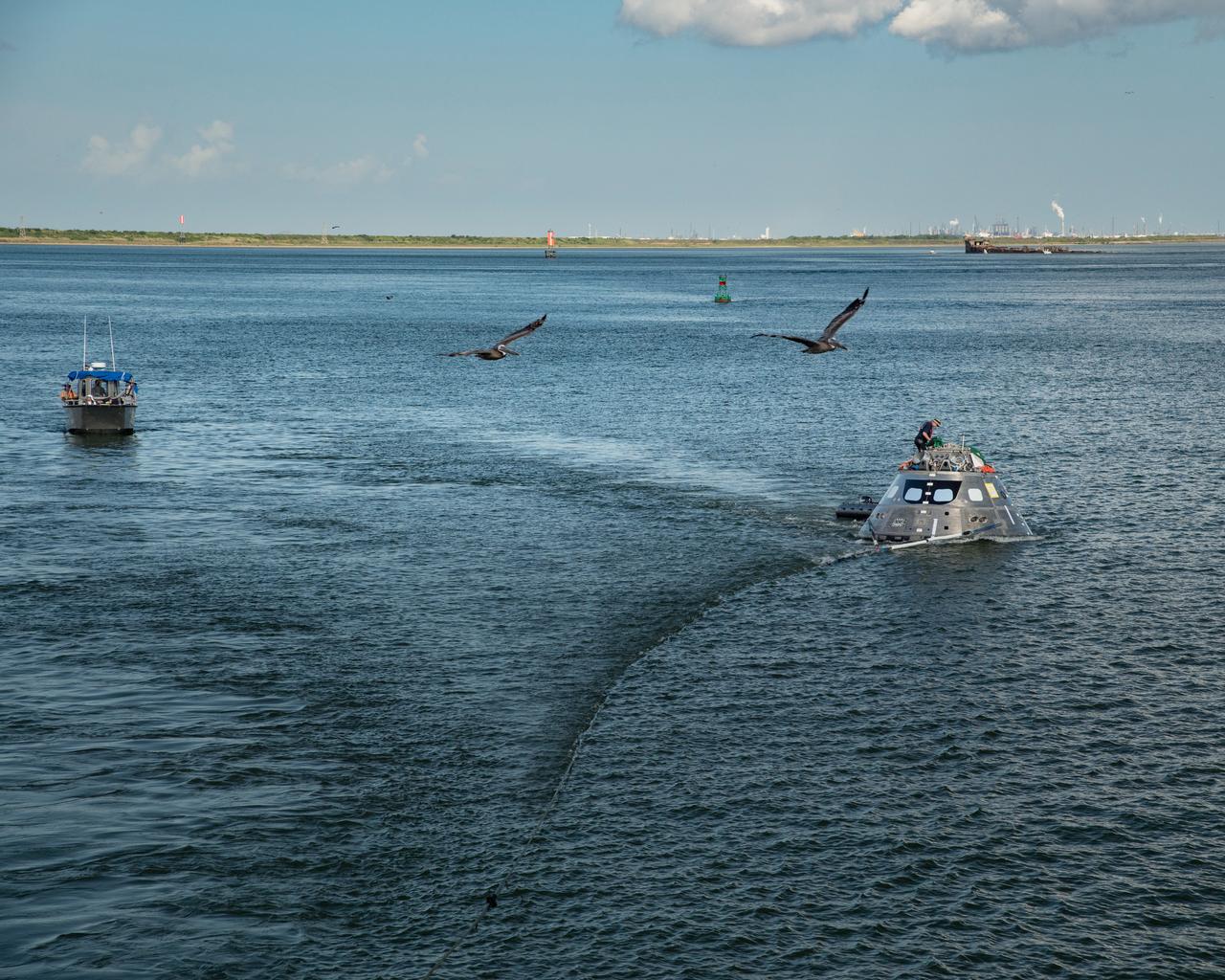
When astronauts return to Earth from destinations beyond the Moon in NASA’s Orion spacecraft and splashdown in the Pacific Ocean, they’ll still need to safely get out of the spacecraft and back on dry land. Using the waters off the coast of Galveston, Texas, a NASA and Department of Defense team test Orion exit procedures in a variety of scenarios on July 11, 2017. Part of Batch images transfer from Flickr.
When astronauts return to Earth from destinations beyond the Moon in NASA’s Orion spacecraft and splashdown in the Pacific Ocean, they’ll still need to safely get out of the spacecraft and back on dry land. Using the waters off the coast of Galveston, Texas, a NASA and Department of Defense team test Orion exit procedures in a variety of scenarios on July 11, 2017. Part of Batch images transfer from Flickr.
When astronauts return to Earth from destinations beyond the Moon in NASA’s Orion spacecraft and splashdown in the Pacific Ocean, they’ll still need to safely get out of the spacecraft and back on dry land. Using the waters off the coast of Galveston, Texas, a NASA and Department of Defense team test Orion exit procedures in a variety of scenarios on July 11, 2017. Part of Batch images transfer from Flickr.
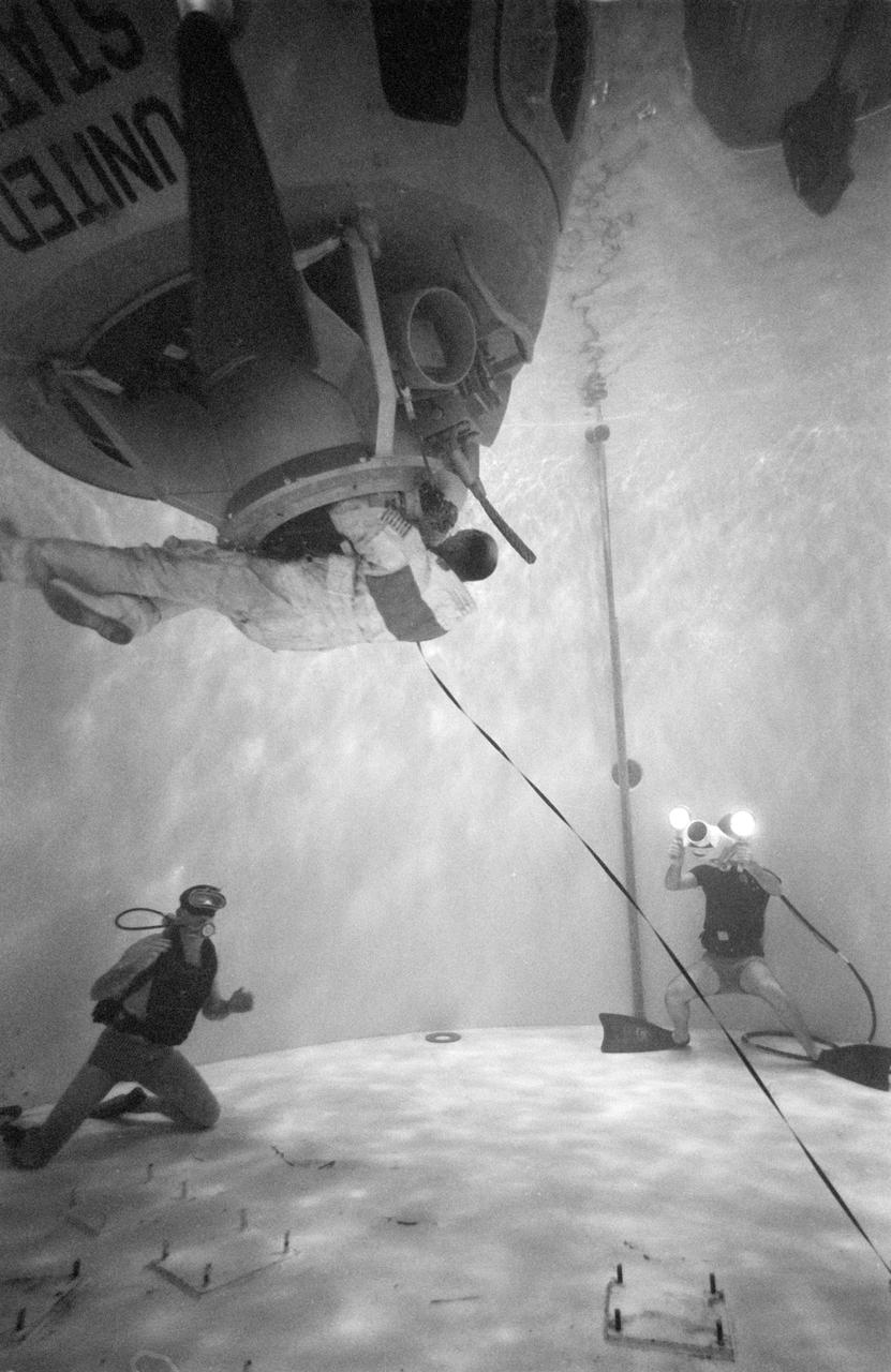
S71-58148 (1 Dec. 1971) --- Astronaut Thomas K. Mattingly II, command module pilot of the planned Apollo 16 lunar landing mission, participates in extravehicular activity (EVA) simulations in the water facility tank in Building 5 at the Manned Spacecraft Center (MSC), Houston, Texas, during training preparations for the forthcoming mission. Mattingly is scheduled to perform EVA during the trans-Earth journey of the Apollo 16 mission.
When astronauts return to Earth from destinations beyond the Moon in NASA’s Orion spacecraft and splashdown in the Pacific Ocean, they’ll still need to safely get out of the spacecraft and back on dry land. Using the waters off the coast of Galveston, Texas, a NASA and Department of Defense team test Orion exit procedures in a variety of scenarios on July 11, 2017. Part of Batch images transfer from Flickr.
When astronauts return to Earth from destinations beyond the Moon in NASA’s Orion spacecraft and splashdown in the Pacific Ocean, they’ll still need to safely get out of the spacecraft and back on dry land. Using the waters off the coast of Galveston, Texas, a NASA and Department of Defense team test Orion exit procedures in a variety of scenarios on July 11, 2017. Part of Batch images transfer from Flickr.
When astronauts return to Earth from destinations beyond the Moon in NASA’s Orion spacecraft and splashdown in the Pacific Ocean, they’ll still need to safely get out of the spacecraft and back on dry land. Using the waters off the coast of Galveston, Texas, a NASA and Department of Defense team test Orion exit procedures in a variety of scenarios on July 11, 2017. Part of Batch images transfer from Flickr.
When astronauts return to Earth from destinations beyond the Moon in NASA’s Orion spacecraft and splashdown in the Pacific Ocean, they’ll still need to safely get out of the spacecraft and back on dry land. Using the waters off the coast of Galveston, Texas, a NASA and Department of Defense team test Orion exit procedures in a variety of scenarios on July 11, 2017. Part of Batch images transfer from Flickr.
When astronauts return to Earth from destinations beyond the Moon in NASA’s Orion spacecraft and splashdown in the Pacific Ocean, they’ll still need to safely get out of the spacecraft and back on dry land. Using the waters off the coast of Galveston, Texas, a NASA and Department of Defense team test Orion exit procedures in a variety of scenarios on July 11, 2017. Part of Batch images transfer from Flickr.
When astronauts return to Earth from destinations beyond the Moon in NASA’s Orion spacecraft and splashdown in the Pacific Ocean, they’ll still need to safely get out of the spacecraft and back on dry land. Using the waters off the coast of Galveston, Texas, a NASA and Department of Defense team test Orion exit procedures in a variety of scenarios on July 11, 2017. Part of Batch images transfer from Flickr.
When astronauts return to Earth from destinations beyond the Moon in NASA’s Orion spacecraft and splashdown in the Pacific Ocean, they’ll still need to safely get out of the spacecraft and back on dry land. Using the waters off the coast of Galveston, Texas, a NASA and Department of Defense team test Orion exit procedures in a variety of scenarios on July 11, 2017. Part of Batch images transfer from Flickr.
When astronauts return to Earth from destinations beyond the Moon in NASA’s Orion spacecraft and splashdown in the Pacific Ocean, they’ll still need to safely get out of the spacecraft and back on dry land. Using the waters off the coast of Galveston, Texas, a NASA and Department of Defense team test Orion exit procedures in a variety of scenarios on July 11, 2017. Part of Batch images transfer from Flickr.
When astronauts return to Earth from destinations beyond the Moon in NASA’s Orion spacecraft and splashdown in the Pacific Ocean, they’ll still need to safely get out of the spacecraft and back on dry land. Using the waters off the coast of Galveston, Texas, a NASA and Department of Defense team test Orion exit procedures in a variety of scenarios on July 11, 2017. Part of Batch images transfer from Flickr.
When astronauts return to Earth from destinations beyond the Moon in NASA’s Orion spacecraft and splashdown in the Pacific Ocean, they’ll still need to safely get out of the spacecraft and back on dry land. Using the waters off the coast of Galveston, Texas, a NASA and Department of Defense team test Orion exit procedures in a variety of scenarios on July 11, 2017. Part of Batch images transfer from Flickr.
When astronauts return to Earth from destinations beyond the Moon in NASA’s Orion spacecraft and splashdown in the Pacific Ocean, they’ll still need to safely get out of the spacecraft and back on dry land. Using the waters off the coast of Galveston, Texas, a NASA and Department of Defense team test Orion exit procedures in a variety of scenarios on July 11, 2017. Part of Batch images transfer from Flickr.
When astronauts return to Earth from destinations beyond the Moon in NASA’s Orion spacecraft and splashdown in the Pacific Ocean, they’ll still need to safely get out of the spacecraft and back on dry land. Using the waters off the coast of Galveston, Texas, a NASA and Department of Defense team test Orion exit procedures in a variety of scenarios on July 11, 2017. Part of Batch images transfer from Flickr.
When astronauts return to Earth from destinations beyond the Moon in NASA’s Orion spacecraft and splashdown in the Pacific Ocean, they’ll still need to safely get out of the spacecraft and back on dry land. Using the waters off the coast of Galveston, Texas, a NASA and Department of Defense team test Orion exit procedures in a variety of scenarios on July 11, 2017. Part of Batch images transfer from Flickr.
When astronauts return to Earth from destinations beyond the Moon in NASA’s Orion spacecraft and splashdown in the Pacific Ocean, they’ll still need to safely get out of the spacecraft and back on dry land. Using the waters off the coast of Galveston, Texas, a NASA and Department of Defense team test Orion exit procedures in a variety of scenarios on July 11, 2017. Part of Batch images transfer from Flickr.
When astronauts return to Earth from destinations beyond the Moon in NASA’s Orion spacecraft and splashdown in the Pacific Ocean, they’ll still need to safely get out of the spacecraft and back on dry land. Using the waters off the coast of Galveston, Texas, a NASA and Department of Defense team test Orion exit procedures in a variety of scenarios on July 11, 2017. Part of Batch images transfer from Flickr.
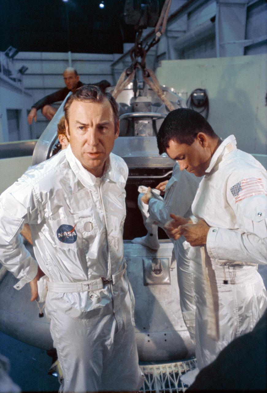
S70-24016 (17 Jan. 1970) --- Astronaut Thomas K. Mattingly II, command module pilot of the Apollo 13 lunar landing mission, participates in water egress training in a water tank in Building 260 at the Manned Spacecraft Center.
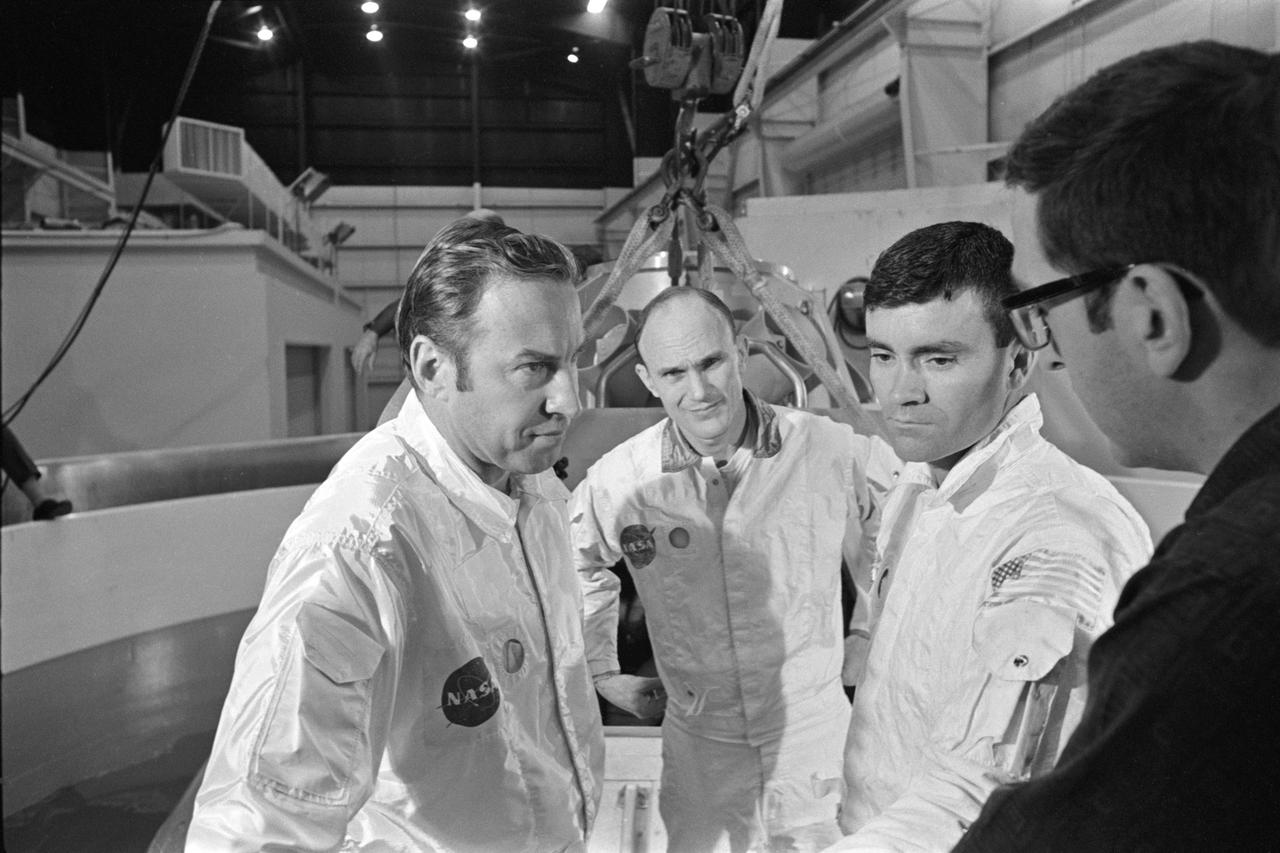
S70-24014 (17 Jan. 1970) --- The three prime crewmen of the Apollo 13 lunar landing mission stand by to participate in water egress training in a water tank in Building 260 at the Manned Spacecraft Center. They were (left to right) astronauts James A. Lovell Jr., commander; Thomas K. Mattingly II, command module pilot; and Fred W. Haise Jr., lunar module pilot.
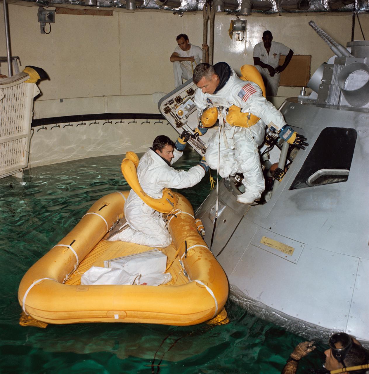
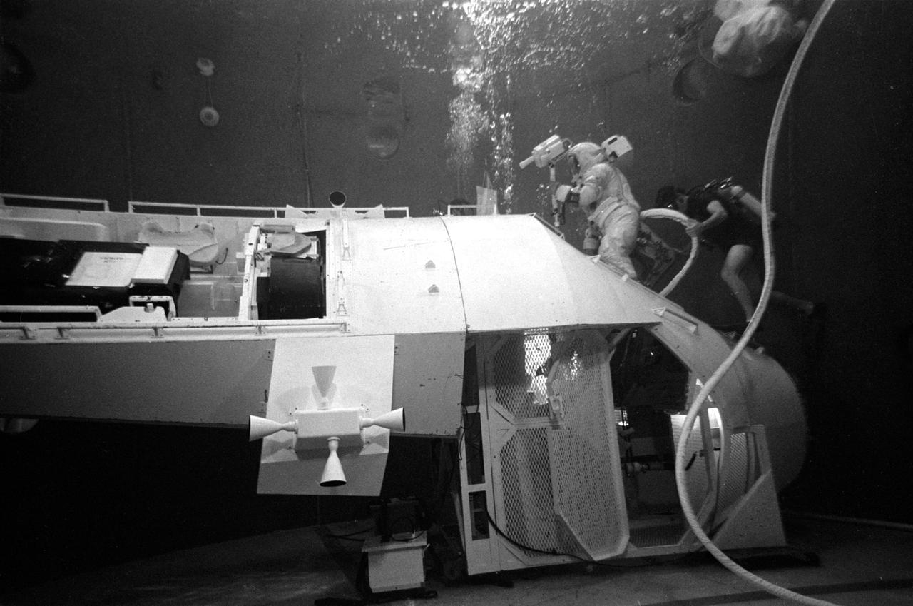
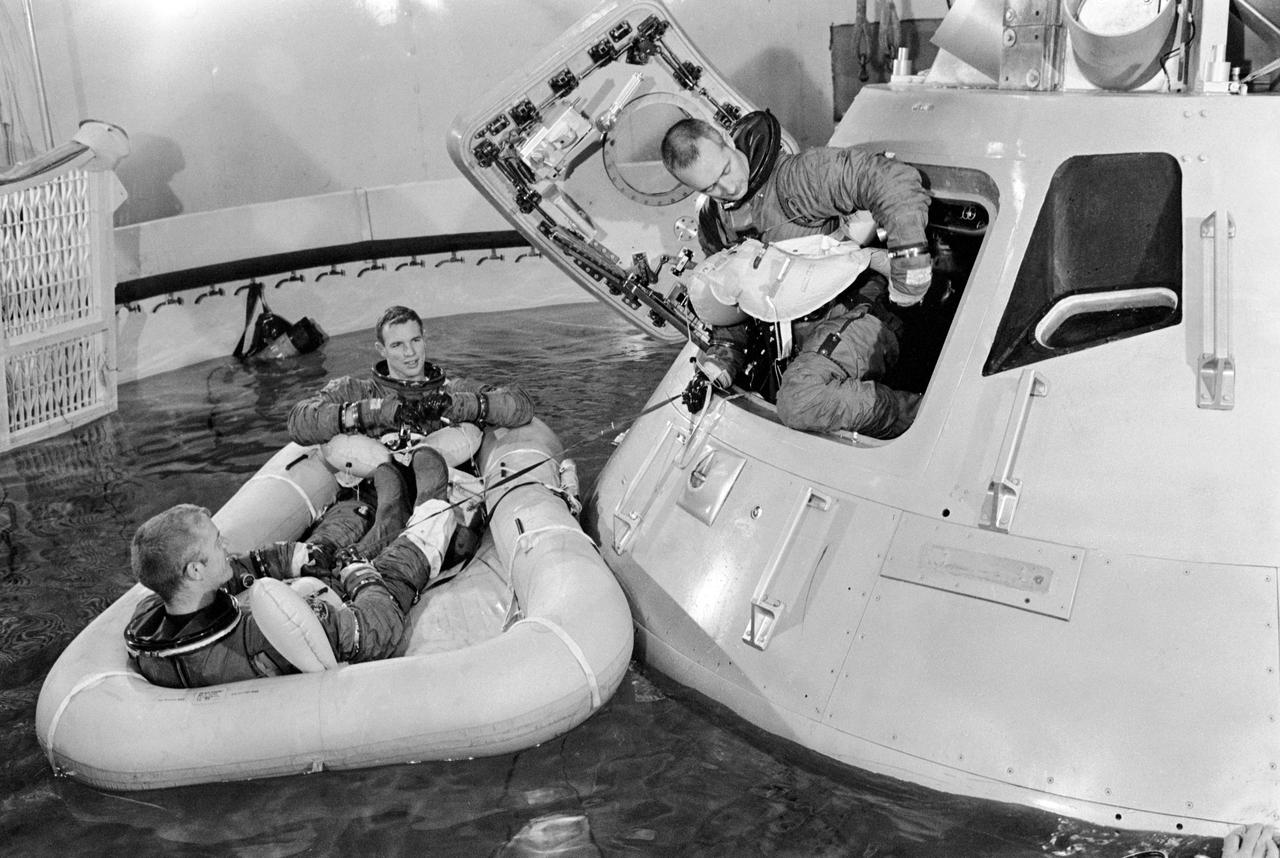
S68-41683 (August 1968) --- Three astronauts participate in Apollo water egress training in a tank in Building 260 at the Manned Spacecraft Center. Already in life raft is John W. Young. Eugene A. Cernan is egressing the Apollo Command Module trainer. Inside the trainer and almost obscured is Thomas P. Stafford.
S70-24010 (17 Jan. 1970) --- The three prime crew members of the Apollo 13 lunar landing mission stand by to participate in water egress training in a water tank in Building 260 at the Manned Spacecraft Center (MSC). They are astronauts James A. Lovell Jr., (left) commander; Fred W. Haise Jr., (right) lunar module pilot; and Thomas K. Mattingly II (in background, obscured by Haise), command module pilot.
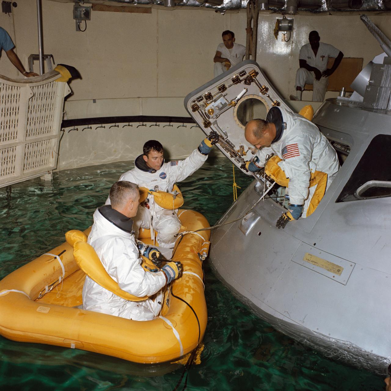
S68-41685 (August 1968) --- Three astronauts participate in Apollo water egress training in a tank in Building 260 at the Manned Spacecraft Center. Egressing the Apollo Command Module trainer is Thomas P. Stafford. Already in life raft are Eugene A. Cernan (in foreground) and John W. Young.
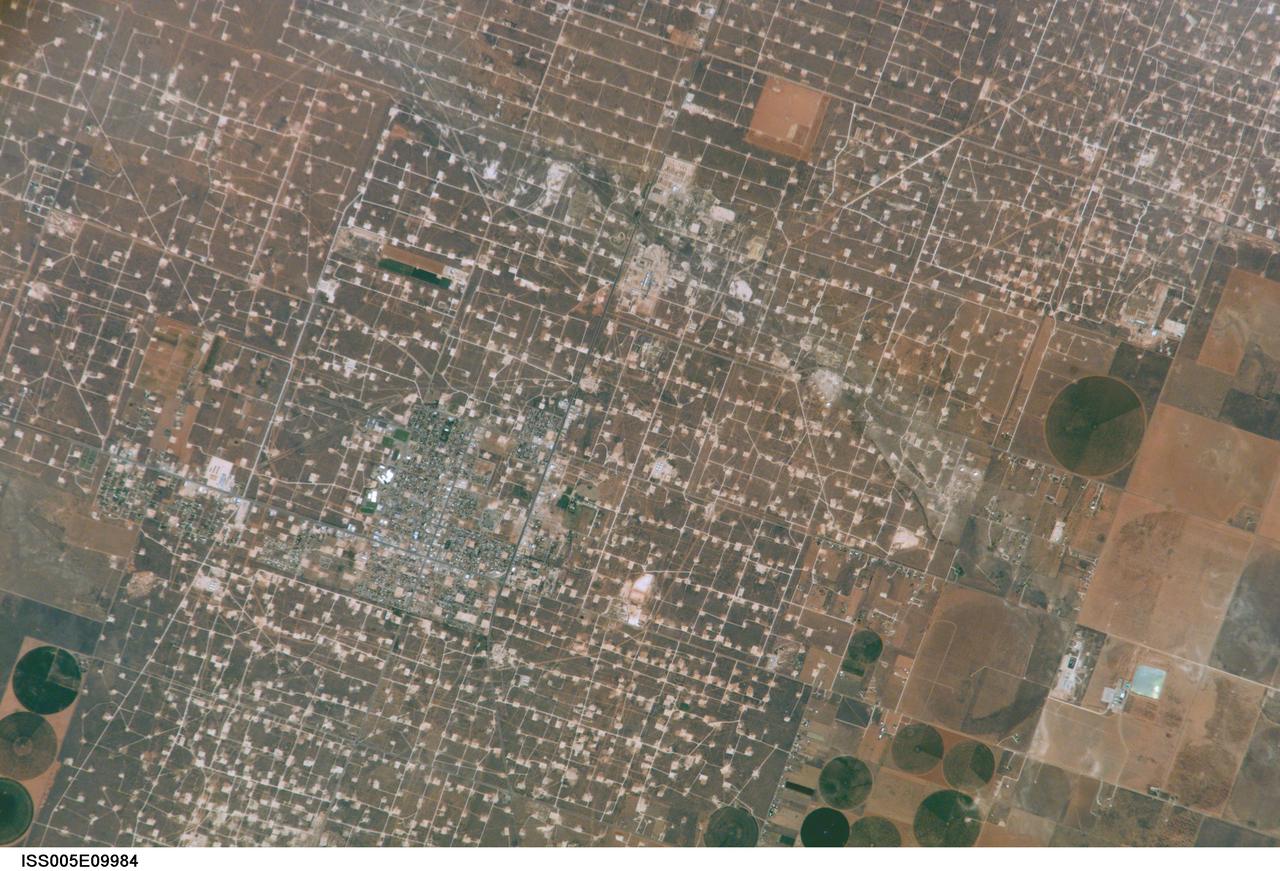
ISS005-E-9984 (17 August 2002) --- This digital still photograph, taken from the International Space Station (ISS) during its fifth staffing, depicts both agriculture and the petroleum industry, which compete for land use near Denver City, Texas. The photo was recently released by the Earth Sciences and Image Analysis Laboratory at Johnson Space Center. The area is southwest of Lubbock near the New Mexico border. According to analysts studying the station imagery, the economy of this region is almost completely dependent on its underground resources of petroleum and water. Both resources result in distinctive land use patterns visible from space. Historically this area has produced vast quantities of oil and gas since development began in the 1930s. A fine, light-colored grid of roads and pipelines connect well sites over this portion of the Wasson Oil Field, one of the state’s most productive. Since the 1940s, agricultural land use has shifted from grazing to irrigated cultivation of cotton, sorghum, wheat, hay, and corn. The water supply is drawn from wells tapping the vast Ogallala Aquifer. Note the large, circular center-pivot irrigation systems in the lower corners of the image. The largest is nearly a mile in diameter.
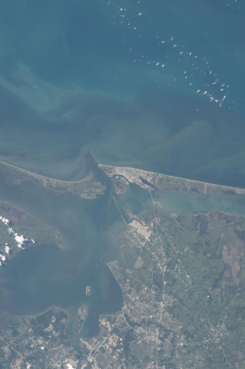
ISS036-E-037747 (28 Aug. 2013) --- One of the Expedition 36 crew members aboard the International Space Station on Aug. 28 photographed this vertical image that shows much of Galveston County and a small portion of southeast Harris County, Texas. Gulf of Mexico waters take up the top half of the picture. Galveston Island runs from just left of center through center right of the image, and the Bolivar Peninsula, highly impacted by Hurricane Ike five years ago, is the land mass at left center. Galveston Bay takes up much of the lower left quadrant of the pictured area. The NASA Johnson Space Center, the normal work place for NASA astronauts Chris Cassidy and Karen Nyberg, currently onboard the orbital complex, is in the bottom portion of the frame.
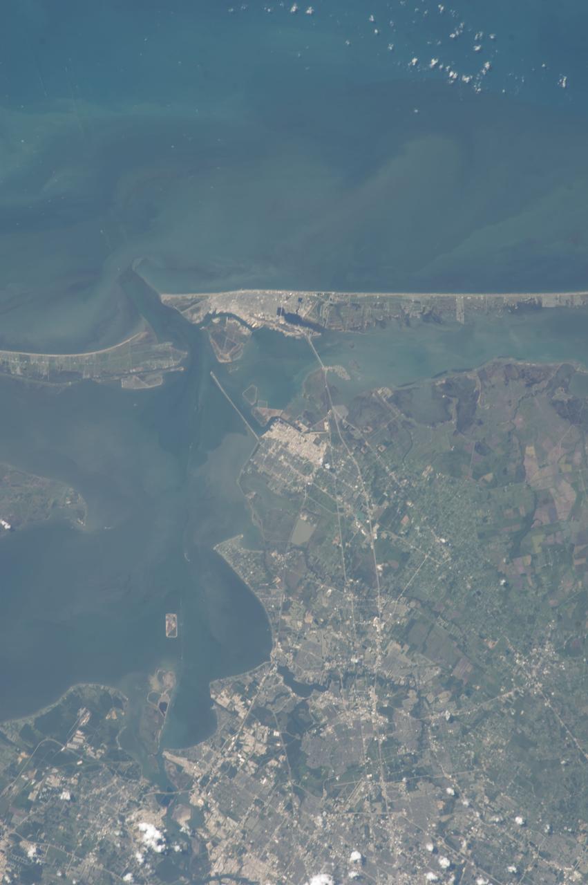
ISS036-E-037751 (28 Aug. 2013) --- One of the Expedition 36 crew members aboard the International Space Station on Aug. 28 photographed this vertical image that shows much of Galveston County and a small portion of southeast Harris County, Texas. Gulf of Mexico waters take up the top one third of the picture. Galveston Island runs from just left of top center through top right of the image, and the Bolivar Peninsula, highly impacted by Hurricane Ike five years ago, is the land mass at top left. Galveston Bay is on the left side of the lower part of the frame. The NASA Johnson Space Center, the normal work place for NASA astronauts Chris Cassidy and Karen Nyberg, currently onboard the orbital complex, is in the bottom portion of the frame.
S70-31143 (17 Jan. 1970) --- Astronaut Fred W. Haise Jr., lunar module pilot of the Apollo 13 lunar landing mission, participates in water egress training in a water tank in Building 260 at the Manned Spacecraft Center.
S68-54859 (November 1968) --- The prime crew of the Apollo 9 (Spacecraft 104/Lunar Module 3/Saturn 504) space mission participates in water egress training in a tank in Building 260 at the Manned Spacecraft Center. Egressing the Apollo command module boilerplate is astronaut James A. McDivitt, commander. In life raft are astronauts David R. Scott (background), command module pilot; and Russell L. Schweickart, lunar module pilot.
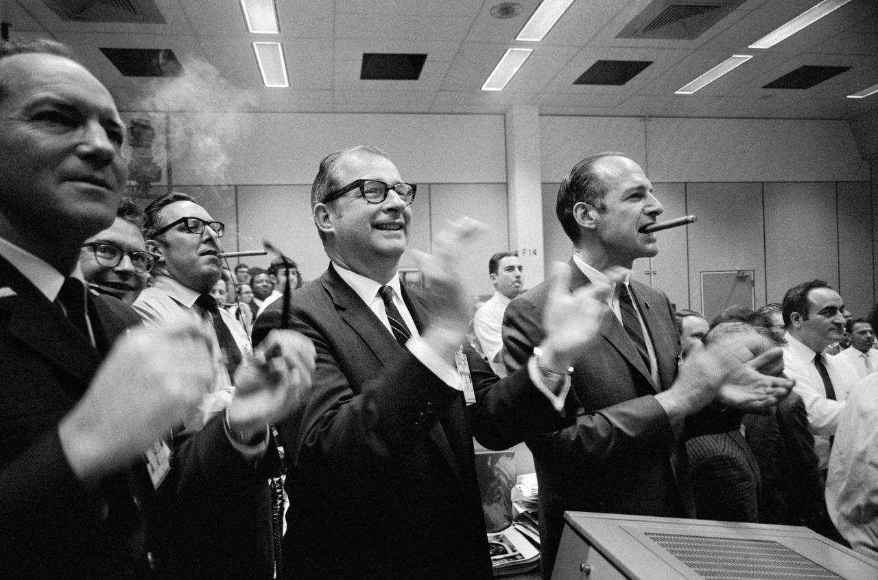
S70-35148 (17 April 1970) --- Staff members from NASA Headquarters (NASA HQ), Manned Spacecraft Center (MSC), and Dr. Thomas Paine (center of frame) applaud the successful splashdown of the Apollo 13 mission while Dr. George Low smokes a cigar (right), in the MSC Mission Control Center (MCC), located in Building 30. Apollo 13 crewmembers, astronauts James A. Lovell Jr., commander; John L. Swigert Jr., command module pilot; and Fred W. Haise Jr., lunar module pilot, splashed down at 12:07:44 p.m. (CST), April 17, 1970, in the south Pacific Ocean.
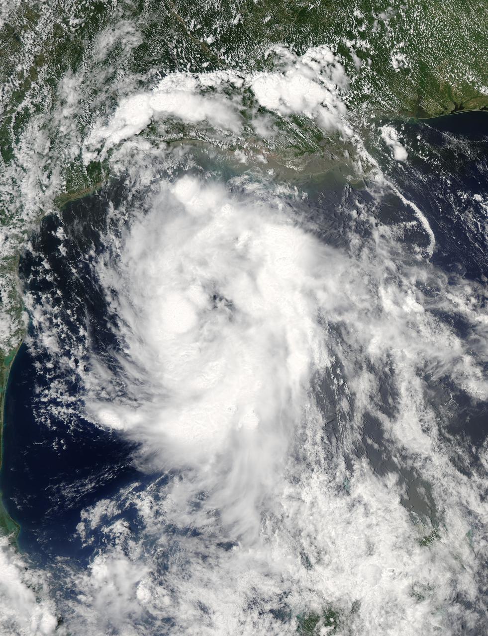
On June 15 at 19:15 UTC (3:15 p.m. EDT) the MODIS instrument aboard NASA's Aqua satellite captured a visible image of Tropical Storm Bill approaching Texas and Louisiana. Powerful thunderstorms circled the center in fragmented bands. At 11 a.m. CDT on June 16, a Tropical Storm Warning was in effect from Baffin Bay to High Island Texas as Bill was making landfall. The National Hurricane Center noted that Bill is expected to produce total rain accumulations of 4 to 8 inches over eastern Texas and eastern Oklahoma and 2 to 4 inches over western Arkansas and southern Missouri, with possible isolated maximum amounts of 12 inches in eastern Texas. In eastern Texas and far western Louisiana today and tonight, isolated tornadoes are also possible, as with any landfalling tropical storm. Tropical storm conditions are expected to continue into the evening in the warning area. Along the coasts, the combination of a storm surge and the tide will cause normally dry areas near the coast to be flooded by rising waters. The water could reach the following heights above ground if the peak surge occurs at the time of high tide. The NHC noted that the Upper Texas coast could experience 2 to 4 feet, and the western Louisiana coast between 1 to 2 feet. At 10 a.m. CDT (1500 UTC), the center of Tropical Storm Bill was located near latitude 28.2 North, longitude 96.4 West. Bill was moving toward the northwest near 10 mph (17 kph) and that general motion is expected to continue today. The latest minimum central pressure reported by an Air Force Reserve Hurricane Hunter aircraft was 997 millibars. Reports from an Air Force Reserve reconnaissance aircraft indicate that maximum sustained winds remain near 60 mph (95 kph) with higher gusts. Unlike Carlos, Bill is not a compact storm. Tropical-storm-force winds extend outward up to 150 miles (240 km) from the center. Between 9 and 10 a.m. CDT, an automated observing station at Port O'Connor also reported a sustained wind of 44 mph (70 kph) and a gust to 53 mph (85 kph). For updated forecasts, watches and warnings, visit the National Hurricane Center webpage at <a href="http://www.nhc.noaa.gov" rel="nofollow">www.nhc.noaa.gov</a>. For local forecasts and advisories, visit: <a href="http://www.weather.gov" rel="nofollow">www.weather.gov</a>. Bill is forecast to continue moving inland and is expected to be a tropical depression by Wednesday, June 17, west of Dallas. The remnants of Bill are forecast to move into the Midwest later in the week. Credit: NASA/GSFC/Jeff Schmaltz/MODIS Land Rapid Response Team <b><a href="http://www.nasa.gov/audience/formedia/features/MP_Photo_Guidelines.html" rel="nofollow">NASA image use policy.</a></b> <b><a href="http://www.nasa.gov/centers/goddard/home/index.html" rel="nofollow">NASA Goddard Space Flight Center</a></b> enables NASA’s mission through four scientific endeavors: Earth Science, Heliophysics, Solar System Exploration, and Astrophysics. Goddard plays a leading role in NASA’s accomplishments by contributing compelling scientific knowledge to advance the Agency’s mission. <b>Follow us on <a href="http://twitter.com/NASAGoddardPix" rel="nofollow">Twitter</a></b> <b>Like us on <a href="http://www.facebook.com/pages/Greenbelt-MD/NASA-Goddard/395013845897?ref=tsd" rel="nofollow">Facebook</a></b> <b>Find us on <a href="http://instagrid.me/nasagoddard/?vm=grid" rel="nofollow">Instagram</a></b>

NASA's Ecosystem Spaceborne Thermal Radiometer Experiment on Space Station (ECOSTRESS) instrument recorded this image of ground surface temperatures in Dallas and Fort Worth, Texas, on June 20, 2022, at 7:17 a.m. Central Daylight Time. Even early in the day, manmade urban surfaces near city centers and transportation networks – streets, roads, and highways shown in red and orange – are warmer than the outskirts by up to 18 degrees Fahrenheit (10 degrees Celsius). The paved surfaces at Dallas/Fort Worth International Airport, shown in red near the top-center of the image, had the warmest temperatures, exceeding 86 F (30 C). Natural land surfaces such as vegetation and streams in rural areas, shown in green and blue, are cooler than nearby large bodies of water, shown in red and yellow, that tend to retain more heat overnight due to their higher heat capacity. Cities are usually warmer than open land because of human activities and the materials used in building and construction. Streets are often the hottest part of the built environment due to asphalt paving. Dark-colored surfaces absorb more heat from the Sun than lighter-colored ones; asphalt absorbs up to 95% of solar radiation and retains the heat for hours into the nighttime. ECOSTRESS measures the temperature of the ground, which is hotter than the air temperature during the daytime. The instrument launched to the space station in 2018. Its primary mission is to identify plants' thresholds for water use and water stress, giving insight into their ability to adapt to a warming climate. However, ECOSTRESS is also useful for documenting other heat-related phenomena, like patterns of heat absorption and retention. Its high-resolution images, with a pixel size of about 225 feet (70 meters) by 125 feet (38 meters), are a powerful tool for understanding our environment. https://photojournal.jpl.nasa.gov/catalog/PIA25422
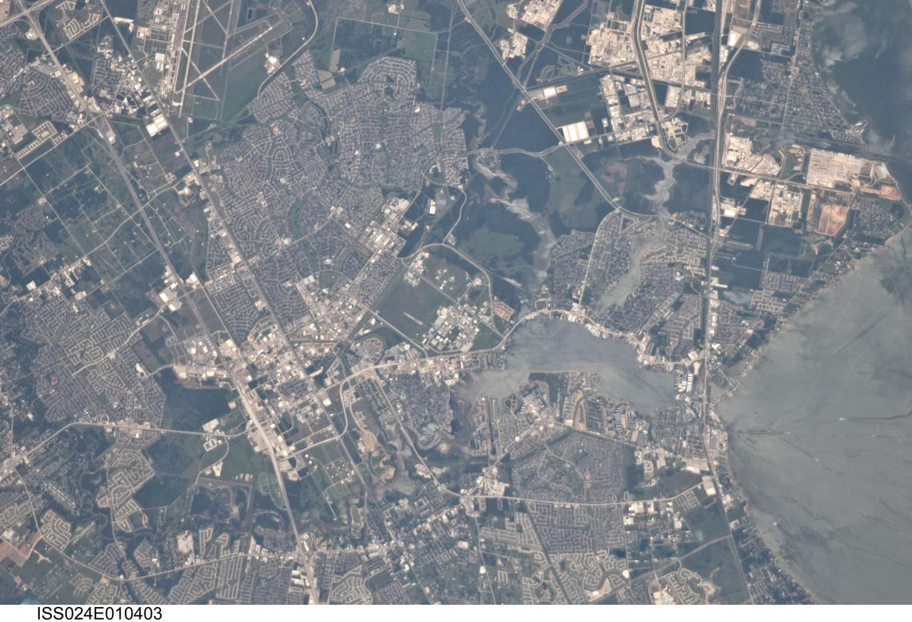
ISS024-E-010403 (31 July 2010) --- This detailed image ? photographed by an Expedition 24 crew member on the International Space Station (ISS) ? is centered on the NASA Lyndon B. Johnson Space Center (JSC), located in the southeastern Houston, TX metropolitan area. While initially being represented by a number of temporary locations in Houston, the facility was established in 1961 as the Manned Spacecraft Center and renamed in honor of the late U.S. President Johnson (a Texas native) in 1973. JSC serves as the lead NASA center for both astronaut training and mission control of manned spacecraft - such as the ISS and space shuttle - and has done so throughout the history of the U.S. manned space program. The Center also collaborates with other NASA and international partner facilities in a variety of scientific and engineering programs related to human spaceflight and planetary exploration. JSC is located approximately midway between downtown Houston and Galveston, TX, and is bordered by several smaller municipalities that form a mosaic of urban and suburban land use (grey areas with street grids, and commercial/industrial areas characterized by white rooftops). Large tracts of grassy fields and forests in the area (light to dark green respectively) include nature preserves, grazing lands, and flood control areas. Also visible at upper left is Ellington Field. This airport services a variety of NASA aircraft used for astronaut training, scientific, and cargo transport purposes. Clear Lake, an inlet of Galveston Bay, is located to the immediate southeast of JSC. Both Clear Lake and Galveston Bay appear silver-grey due to sunglint, or light reflected back towards the observer on the ISS that gives the water surface a mirror-like appearance. Several boat wakes are visible in Galveston Bay (right) due to disruption of the water surface that reduces the sunglint effect.

This image of Houston, Texas, shows the amount of detail that is possible to obtain using spaceborne radar imaging. Images such as this -- obtained by the Spaceborne Imaging Radar-C/X-band Synthetic Aperture Radar (SIR-C/X-SAR) flying aboard the space shuttle Endeavor last fall -- can become an effective tool for urban planners who map and monitor land use patterns in urban, agricultural and wetland areas. Central Houston appears pink and white in the upper portion of the image, outlined and crisscrossed by freeways. The image was obtained on October 10, 1994, during the space shuttle's 167th orbit. The area shown is 100 kilometers by 60 kilometers (62 miles by 38 miles) and is centered at 29.38 degrees north latitude, 95.1 degrees west longitude. North is toward the upper left. The pink areas designate urban development while the green-and blue-patterned areas are agricultural fields. Black areas are bodies of water, including Galveston Bay along the right edge and the Gulf of Mexico at the bottom of the image. Interstate 45 runs from top to bottom through the image. The narrow island at the bottom of the image is Galveston Island, with the city of Galveston at its northeast (right) end. The dark cross in the upper center of the image is Hobby Airport. Ellington Air Force Base is visible below Hobby on the other side of Interstate 45. Clear Lake is the dark body of water in the middle right of the image. The green square just north of Clear Lake is Johnson Space Center, home of Mission Control and the astronaut training facilities. The black rectangle with a white center that appears to the left of the city center is the Houston Astrodome. The colors in this image were obtained using the follow radar channels: red represents the L-band (horizontally transmitted, vertically received); green represents the C-band (horizontally transmitted, vertically received); blue represents the C-band (horizontally transmitted and received). http://photojournal.jpl.nasa.gov/catalog/PIA01783