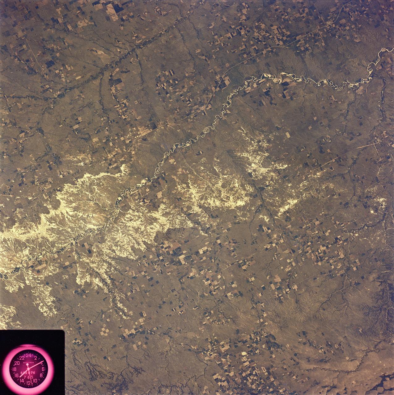
SL2-81-162 (22 June 1973) --- The most striking feature of this scene of the western Great Plains and the Badlands of SD (43.5N, 101.0W) is the rugged topography of the landscape. Over eons of time, the White River has carved out a badlands topography of steep gullies, irregular winding ridges and isolated buttes. The barren wasteland of badlands light toned rock surfaces contrast sharply with the adjacent vegetated landscape of native grasslands and cultivated fields. Photo credit: NASA
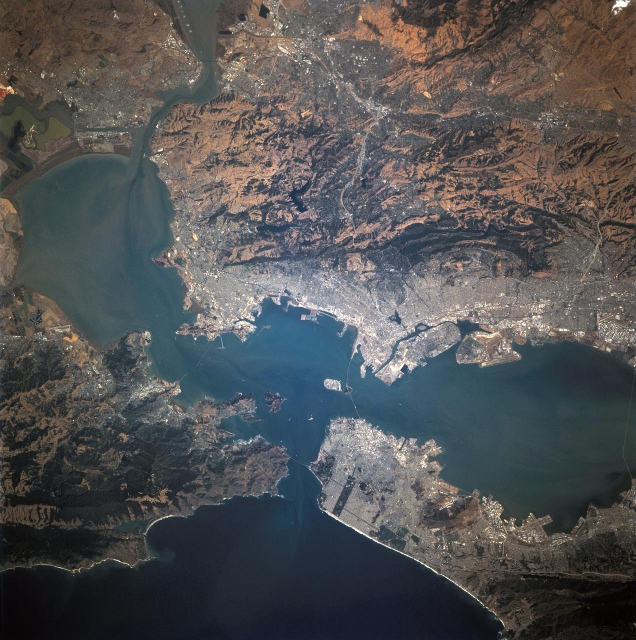
STS068-244-022 (30 September-11 October 1994) --- (San Francisco, San Pablo Bay Area) Photographed through the Space Shuttle Endeavour's flight deck windows, the heavily populated bay area is featured in this 70mm frame. The relatively low altitude of Endeavour's orbit (115 nautical miles) and the use of a 250mm lens on the Hasselblad camera allowed for capturing detail in features such as the Berkeley Marina (frame center). The region's topography is well depicted with the lowland areas heavily populated and the hills much more sparsely covered. The Oakland Hills in the right lower center appear to be re-vegetated after a devastating fire. The Golden Gate Recreation Area in the upper left also shows heavy vegetation. The three bridges across the main part of the bay and their connecting roads are prominent. Cultural features such as Golden Gate Park and the Presidio contrast with the gray of the city.
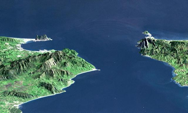
This perspective view shows the Strait of Gibraltar, which is the entrance to the Mediterranean Sea from the Atlantic Ocean. Europe (Spain) is on the left. Africa (Morocco) is on the right. The Rock of Gibraltar, administered by Great Britain, is the peninsula in the back left. The Strait of Gibraltar is the only natural gap in the topographic barriers that separate the Mediterranean Sea from the world's oceans. The Sea is about 3700 kilometers (2300 miles) long and covers about 2.5 million square kilometers (one million square miles), while the Strait is only about 13 kilometers (8 miles) wide. Sediment samples from the bottom of the Mediterranean Sea that include evaporite minerals, soils, and fossil plants show that about five million years ago the Strait was topographically blocked and the Sea had evaporated into a deep basin far lower in elevation than the oceans. Consequent changes in the world's hydrologic cycle, including effects upon ocean salinity, likely led to more ice formation in polar regions and more reflection of sunlight back to space, resulting in a cooler global climate at that time. Today, topography plays a key role in our regional climate patterns. But through Earth history, topographic change, even perhaps over areas as small as 13 kilometers across, has also affected the global climate. This image was generated from a Landsat satellite image draped over an elevation model produced by the Shuttle Radar Topography Mission (SRTM). The view is eastward with a 3-times vertical exaggeration to enhance topographic expression. Natural colors of the scene (green vegetation, blue water, brown soil, white beaches) are enhanced by image processing, inclusion of some infrared reflectance (as green) to highlight the vegetation pattern, and inclusion of shading of the elevation model to further highlight the topographic features. Landsat has been providing visible and infrared views of the Earth since 1972. SRTM elevation data matches the 30-meter (99-feet) resolution of most Landsat images and will substantially help in analyses of the large Landsat image archive. Elevation data used in this image was acquired by the Shuttle Radar Topography Mission (SRTM) aboard the Space Shuttle Endeavour, launched on February 11, 2000. http://photojournal.jpl.nasa.gov/catalog/PIA03397
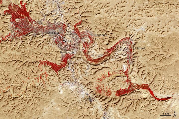
NASA image acquired Feb. 9, 2011 Less than 5 percent of Algeria’s land surface is suitable for growing crops, and most precipitation falls on the Atlas Mountains along the coast. Inland, dust-laden winds blow over rocky plains and sand seas. However, in north central Algeria—off the tip of Grand Erg Occidental and about 450 kilometers (280 miles) south of Algiers—lies a serpentine stretch of vegetation. It is the M’zab Valley, filled with palm groves and dotted with centuries-old settlements. The Advanced Spaceborne Thermal Emission and Reflection Radiometer (ASTER) on NASA’s Terra satellite captured this image of M’zab Valley on February 9, 2011. ASTER combines infrared, red, and green wavelengths of light. Bare rock ranges in color from beige to peach. Buildings and paved surfaces appear gray. Vegetation is red, and brighter shades of red indicate more robust vegetation. This oasis results from water that is otherwise in short supply in the Sahara Desert, thanks to the valley’s approximately 3,000 wells. Chemical analysis of Algerian aquifers, as well studies of topography in Algeria and Tunisia, suggest this region experienced a cooler climate in the late Pleistocene, and potentially heavy monsoon rains earlier in the Holocene. The M’zab region shows evidence of meandering rivers and pinnate drainage patterns. The vegetation lining M’zab Valley highlights this old river valley’s contours. Cool summer temperatures and monsoon rains had long since retreated from the region by eleventh century, but this valley nevertheless supported the establishment of multiple fortified settlements, or ksours. Between 1012 A.D. and 1350 A.D., locals established the ksours of El-Atteuf, Bounoura, Melika, Ghardaïa, and Beni-Isguen. Collectively these cities are now a United Nations Educational, Scientific, and Cultural Organization (UNESCO) World Heritage site. NASA Earth Observatory image by Robert Simmon and Jesse Allen, using data from the GSFC/METI/ERSDAC/JAROS, and U.S./Japan ASTER Science Team. Caption by Michon Scott. Instrument: Terra - ASTER <b>To download the full high res file go <a href="http://earthobservatory.nasa.gov/IOTD/view.php?id=51296" rel="nofollow"> here</a></b>

ISS010-E-05072 (25 October 2004) --- Ibera Swamp topography in northeast Argentina is featured in this image photographed by an Expedition 10 crewmember on the International Space Station (ISS). The central lake in this image is one of hundreds in the Ibera swamplands that were formed by South America’s second largest river, the Parana. Although this great river now lies 120 kilometers to the north, its channel has swung over a great “inland delta” in the recent geological past, according to NASA scientists studying the Expedition 10 photo collection. This and other lakes were captured in this photograph as the sunglint point passed over this remote but vast swampland in northeast Argentina. The glint pattern shows winds ruffling the water surfaces. The lakes in this image lie within side channels of the Parana formed when it flowed through this region. The central lake in the image is about 2 kilometers long. Forest, swamp and prairie vegetation types outline the low topography which consists of lakes, low swells and depressions.

SL4-93-153 (February 1974) --- A vertical view of the Birmingham and central Alabama area is seen in this Skylab 4 Earth Resources Experiments Package S190-B (five-inch earth terrain camera) infrared photographed taken from the Skylab space station in Earth orbit. Illustrated here is the utility of color infrared film in depicting distribution of living vegetation in the 3,600 square mile Birmingham region. The Birmingham industrial complex, with a population of nearly 850,000, is the light gray area nestled in the valley between the northeast-trending ridges that are prominent topographic features in the southern Appalachian Mountains. The narrow ridges and adjacent valleys reflect folded and faulted sedimentary rocks, indicating the complex geological history of the region. Two major rivers and several reservoirs are easily distinguished in this photograph. Bankhand Lake, formed by a dam on the Black Warrior River, appears as bright blue west of Birmingham. Two lakes are formed by dams on the Goosa River east of Birmingham. Federal and state highways appear as thin white lines and are easily identified. Interstate 65 to Montgomery is the prominent white line extending southward from Birmingham. Power line clearings are visible in the center of the picture along the Goosa River, and can be traced northwestward to northern parts of Birmingham. The predominant deep red color of the picture is due to the reflections from living vegetation. In contrast are the light tan areas that commonly occur as rectangular patterns in the east part of the photograph and represent mature agricultural crops or grazing lands. Analysis of the photographic data from the earth terrain camera will be conducted by Dr. H. Jayroe of the Marshall Space Flight Center in developing analytical techniques. All EREP photography is available to the public through the Department of Interior's Earth Resources Observations Systems Data Center, Sioux Falls, South Dakota, 57198. Photo credit: NASA

SL4-93-167 (February 1974) --- A vertical view of the Kennedy Space Center and the Florida Atlantic coast area is seen in this Skylab 4 Earth Resources Experiments Package S190-B (five-inch earth terrain camera) infrared photography taken from the Skylab space station in Earth orbit. This photograph shows the major land-ocean features of the Florida coast near Vero Beach northward to Cape Canaveral and the KSC complex. The launch pads for the Skylab missions are clearly visible. Identification of living vegetation is possible through the use of the color infrared film. Various shades of red portray differences in the vegetation such as shown in the patterns in the agricultural area near Vero Beach. In the Kennedy Space Center, the nearly continuous and uniform red color shows that most of the land areas are heavily vegetated. The white coastal beach areas are strongly contrasted to the red land and the blue Atlantic Ocean. Old dunal areas in KSC are visible on Merritt Island which is separated from the Launch areas by the Banana River and the mainland by the Indian River. Federal and state highways and numerous causeways over the rivers are easily identified. The Florida mainland is partly shadowed by small white clouds which cast a pronounced shadow to the east of each cloud indicated the Sun is west of solar noon. Federal agencies participating with NASA on the EREP project are the Departments of Agriculture, Commerce, Interior, the Environmental Protection Agency and the Core of Engineers. All EREP photography is available to the public through the Department of Interior's Earth Resources Observations Systems Data Center, Sioux Falls, South Dakota, 57198. Photo credit: NASA
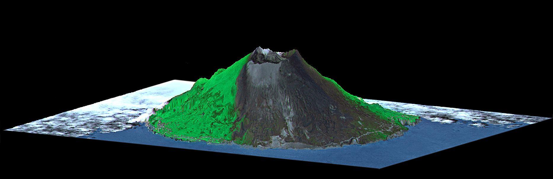
Mount Oyama is a 820-meter-high (2,700 feet) volcano on the island of Miyake-Jima, Japan. In late June 2000, a series of earthquakes alerted scientists to possible volcanic activity. On June 27, authorities evacuated 2,600 people, and on July 8 the volcano began erupting and erupted five times over that week. The dark gray blanket covering green vegetation in the image is the ash deposited by prevailing northeasterly winds between July 8 and 17. This island is about 180 kilometers (110 miles) south of Tokyo and is part of the Izu chain of volcanic islands that runs south from the main Japanese island of Honshu. Miyake-Jima is home to 3,800 people. The previous major eruptions of Mount Oyama occurred in 1983 and 1962, when lava flows destroyed hundreds of houses. An earlier eruption in 1940 killed 11 people. This image is a perspective view created by combining image data from the Advanced Spaceborne Thermal Emission and Reflection Radiometer (ASTER) aboard NASA's Terra satellite with an elevation model from the Shuttle Radar Topography Mission (SRTM). Vertical relief is exaggerated, and the image includes cosmetic adjustments to clouds and image color to enhance clarity of terrain features. http://photojournal.jpl.nasa.gov/catalog/PIA02771
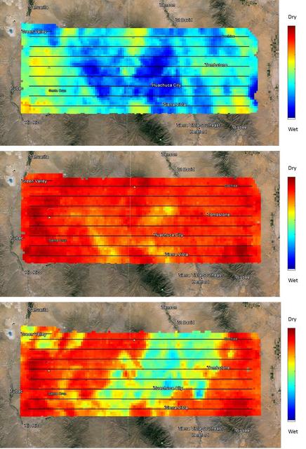
NASA's SMAP (Soil Moisture Active Passive) satellite observatory conducted a field experiment as part of its soil moisture data product validation program in southern Arizona on Aug. 2-18, 2015. The images here represent the distribution of soil moisture over the SMAPVEX15 (SMAP Validation Experiment 2015) experiment domain, as measured by the Passive Active L-band System (PALS) developed by NASA's Jet Propulsion Laboratory, Pasadena, California, which was installed onboard a DC-3 aircraft operated by Airborne Imaging, Inc. Blue and green colors denote wet conditions and dry conditions are marked by red and orange. The black lines show the nominal flight path of PALS. The measurements show that on the first day, the domain surface was wet overall, but had mostly dried down by the second measurement day. On the third day, there was a mix of soil wetness. The heterogeneous soil moisture distribution over the domain is typical for the area during the North American Monsoon season and provides excellent conditions for SMAP soil moisture product validation and algorithm enhancement. The images are based on brightness temperature measured by the PALS instrument gridded on a grid with 0.6-mile (1-kilometer) pixel size. They do not yet compensate for surface characteristics, such as vegetation and topography. That work is currently in progress. http://photojournal.jpl.nasa.gov/catalog/PIA19879
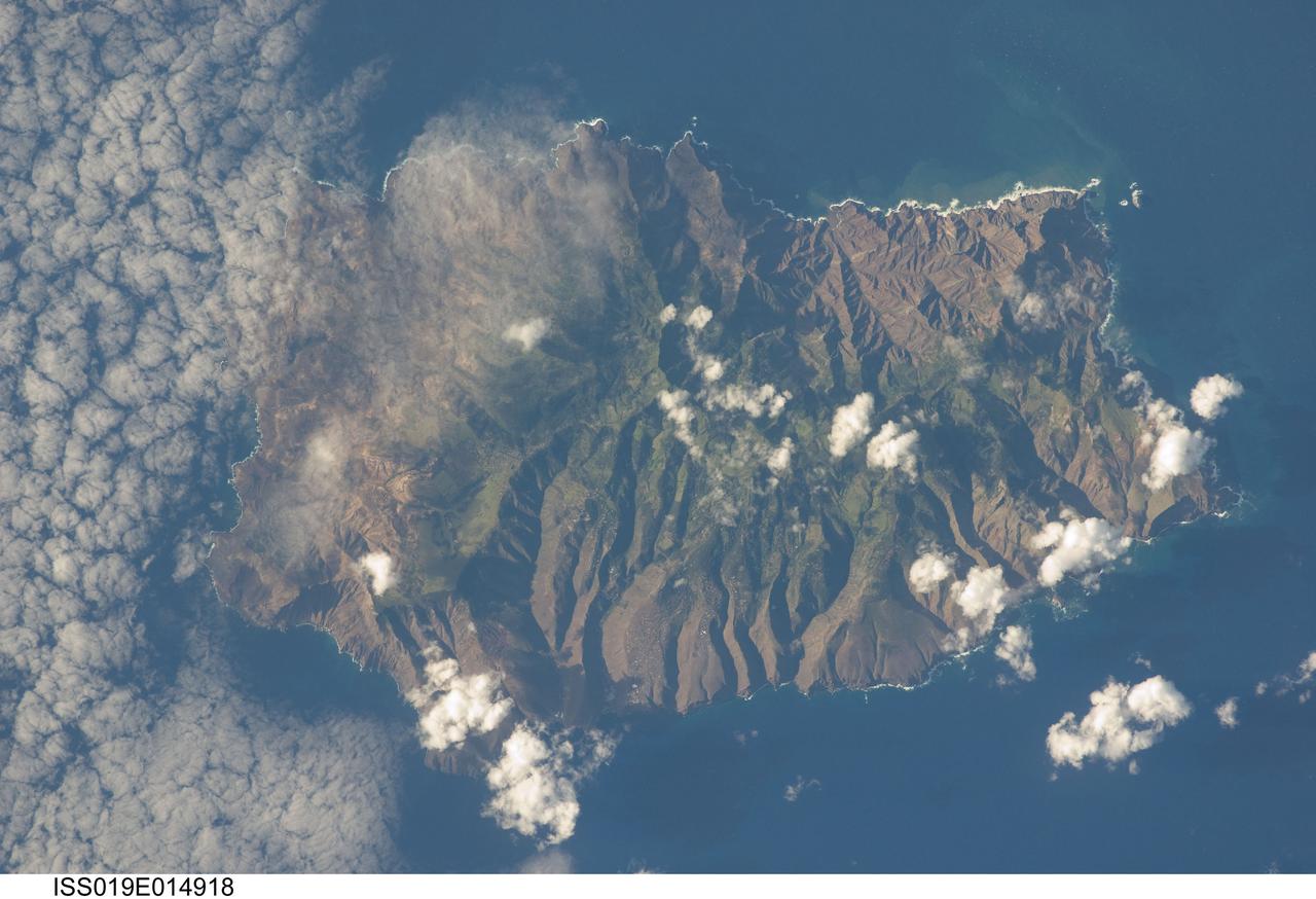
ISS019-E-014918 (7 May 2009) --- Saint Helena Island is featured in this image photographed by an Expedition 19 crewmember on the International Space Station. This isolated island, located in the South Atlantic Ocean approximately 1860 kilometers to the west of the African coastline, is perhaps best known as the final resting place of Napoleon Bonaparte I of France. Bonaparte was exiled to the island following his defeat at the Battle of Waterloo in 1815; he died on the island six years later in 1821. Today, the island is a British Overseas Territory, with access provided thirty times a year by a single ship, the RMS St. Helena. The rugged topography evident in this photograph is the result of erosion of the volcanic rocks that make up the island into sharp peaks and deep ravines. A climatic gradient related to elevation is also evident ? the higher, wetter central portion of the island is covered with green vegetation, whereas the lower coastal areas are drier and hotter with little vegetation cover. Human presence on the island has also caused dramatic changes to the original flora and fauna of the island. Only approximately 10 percent of the forest cover observed by the first explorers now remains in a semi-natural state, and that is concentrated in the interior highlands. Saint Helena Island was also visited by Charles Darwin during his scientific voyages in the 19th century. He visited the island in 1836 aboard HMS Beagle, recording observations of the flora, fauna, and geology that would inform his theory of evolution. This image was acquired by crew members onboard the International Space Station as part of an ongoing project (the HMS Beagle Project) to document current biodiversity in areas visited by Charles Darwin.
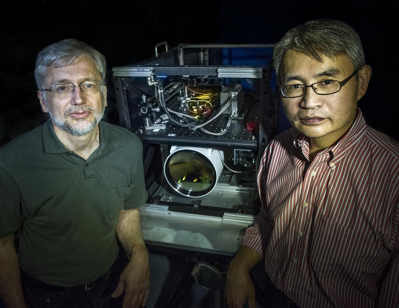
Goddard scientist David Harding and Goddard technologist Tony Yu are developing a lidar system that could meet an ambitious requirement of the proposed LIST mission. ---------- In 2007, the National Research Council threw down a challenge: Design a space-based laser altimeter that could measure the height of Earth's surface everywhere to within a mere 10 centimeters — all at 5-meter resolution. To this day, some believe it can't be done. Goddard scientist Dave Harding begs to differ. He and his team have embraced the challenge and are developing a laser altimeter that could provide the data from a berth onboard the NRC-proposed Lidar Surface Topography, or LIST, mission. It would generate highly detailed maps of topography and vegetation that scientists could use to forecast and respond to natural hazards and study carbon storage in forests. Read more: <a href="http://1.usa.gov/17N3Bql" rel="nofollow">1.usa.gov/17N3Bql</a> <b><a href="http://www.nasa.gov/audience/formedia/features/MP_Photo_Guidelines.html" rel="nofollow">NASA image use policy.</a></b> <b><a href="http://www.nasa.gov/centers/goddard/home/index.html" rel="nofollow">NASA Goddard Space Flight Center</a></b> enables NASA’s mission through four scientific endeavors: Earth Science, Heliophysics, Solar System Exploration, and Astrophysics. Goddard plays a leading role in NASA’s accomplishments by contributing compelling scientific knowledge to advance the Agency’s mission. <b>Follow us on <a href="http://twitter.com/NASA_GoddardPix" rel="nofollow">Twitter</a></b> <b>Like us on <a href="http://www.facebook.com/pages/Greenbelt-MD/NASA-Goddard/395013845897?ref=tsd" rel="nofollow">Facebook</a></b> <b>Find us on <a href="http://instagram.com/nasagoddard?vm=grid" rel="nofollow">Instagram</a></b> Credit: Bill Hrybck/NASA
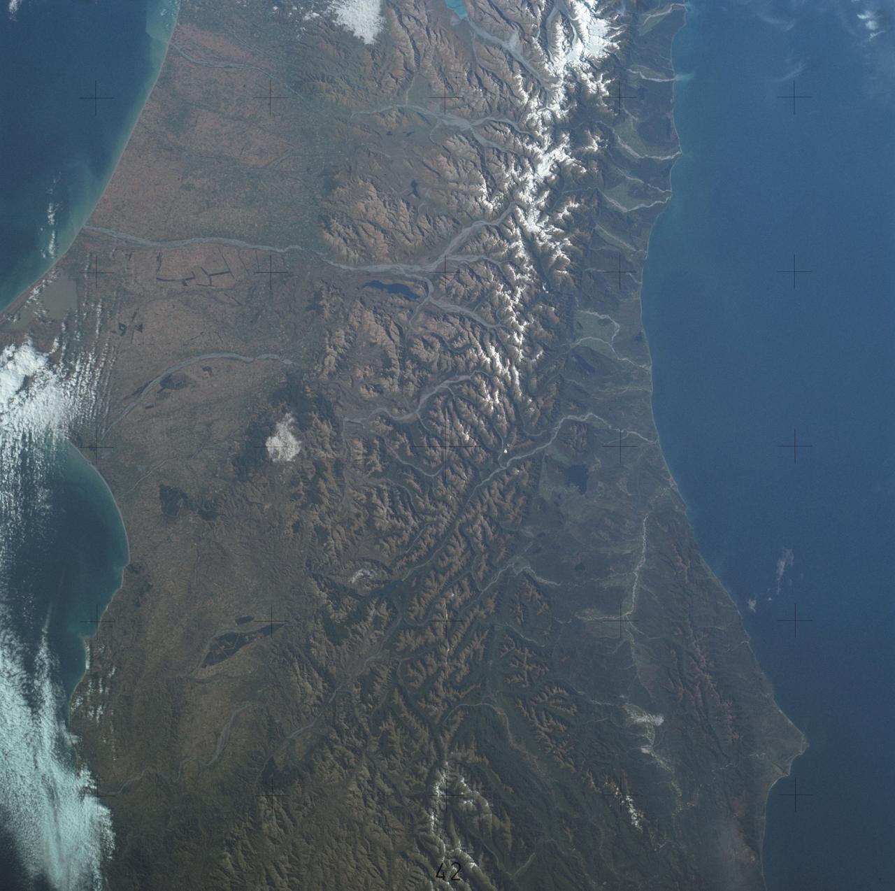
SL4-137-3700 (22 Dec. 1973) --- A near vertical view of a portion of South Island, New Zealand, as see from the Skylab space station in Earth orbit. This picture was taken by one of the Skylab 4 crew members with a handheld 70mm Hasselblad camera using a 100mm lens. The picture should be held with the largest body of water (Tasman Sea) on the left. Cape Foulwind is at the upper left. The City of Christchurch is under clouds at the center right margin. Note the movement of sediment by alongshore currents, especially on the east (right) side of the island. The Alpine Fault, which is part of the circum-Pacific volcanic-tectonic belt, is clearly visible on the left (west) side of the island. The fault line is marked by a scarp, which appears very distinct from orbital altitude. Differences in topography and vegetation on either side of the fault are also sharp. Streams change direction at the fault line, and the change in slope at the fault line is evident in the widening of stream channels. The left side of the fault has moved northeast (upward) relative to the right side; some stream offsets indicate the direction of relative movement, but others are controlled by local topography. The Alpine Fault, which also transects New Zealand's North Island, was photographed and described more than a dozen times by the Skylab 4 crewmen. The circum-Pacific volcanic-tectonic belt is a feature of the Earth's crust which is related to sea floor spreading and continental drift. Though the Alpine Fault is sharply delineated in this photograph, other major crustal features are subtle that their existence was unknown before their observation from orbit. The distance from top to bottom is about 290 kilometers (175 miles). Photo credit: NASA
After draining the northern flank of the Alps Mountains in Germany and Austria, the Danube River flows east as it enters this west-looking scene (upper right) and forms the border between Slovakia and Hungary. The river then leaves the border as it enters Hungary and transects the Transdanubian Mountains, which trend southwest to northeast. Upon exiting the mountains, the river turns southward, flowing past Budapest (purplish blue area) and along the western margin of the Great Hungarian Plain. South and west of the Danube, the Transdanubian Mountains have at most only about 400 meters (about 1300 feet) of relief but they exhibit varied landforms, which include volcanic, tectonic, fluvial (river), and eolian (wind) features. A thick deposit of loess (dust deposits likely blown from ancient glacial outwash) covers much of this area, and winds from the northwest, funneled between the Alps and the Carpathian Mountains, are apparently responsible for a radial pattern of erosional streaks across the entire region. This image was generated from a Landsat satellite image draped over an elevation model produced by the Shuttle Radar Topography Mission (SRTM). The view uses a 3-times vertical exaggeration to enhance topographic expression. The false colors of the scene result from displaying Landsat bands 1, 4, and 7 in blue, green, and red, respectively. Band 1 is visible blue light, but bands 4 and 7 are reflected infrared light. This band combination maximizes color contrasts between the major land cover types, namely vegetation (green), bare ground (red), and water (blue). Shading of the elevation model was used to further highlight the topographic features. http://photojournal.jpl.nasa.gov/catalog/PIA04952
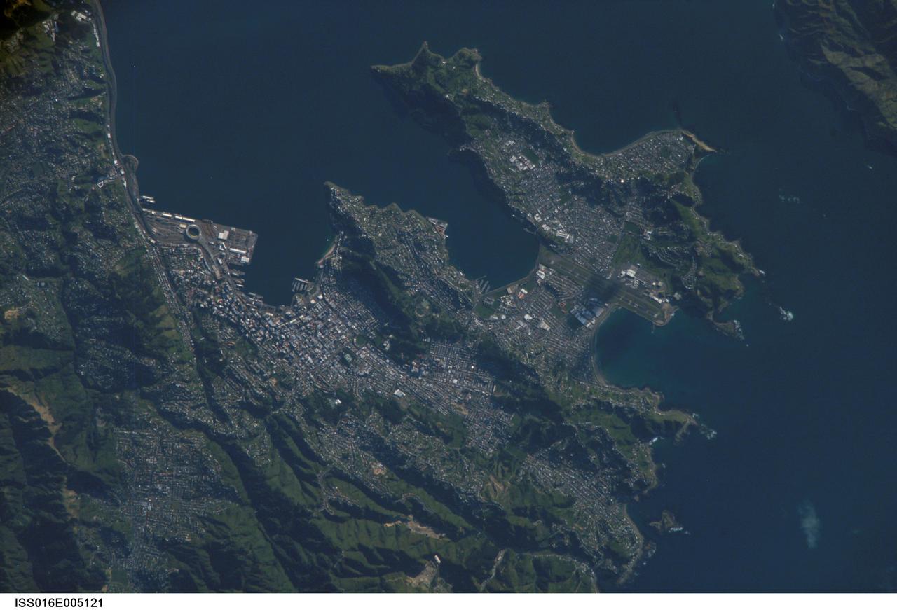
ISS016-E-005121 (21 Oct. 2007) --- Wellington, New Zealand is featured in this image photographed by an Expedition 16 crewmember on the International Space Station. New Zealand's capital of Wellington is located at the southwestern tip of North Island near the Cook Strait. The city is the second largest in New Zealand (after Auckland), and at 41 degrees south latitude, it is the southernmost capital city of the world. The North and South Islands of New Zealand are located along the active Australian-Pacific tectonic plate boundary -- the Islands are only a small part of a larger submerged fragment of continental crust. The glancing collision of these two tectonic plates results in uplift of the land surface, expressed as low hills on North Island and the Southern Alps on South Island. Local topography visible in this view is a result of these tectonic forces and weathering processes, which have exerted a strong influence on the morphology of the city. Tightly clustered white rooftops and high building density of the central business district are visible to the south of the Westpac Stadium between vegetated (green) northeast-southwest trending ridges. Lower density development (gray gridded regions with scattered white rooftops) has spread eastwards along the Miramar Peninsula. Five major faults that run through the Wellington metropolitan area; the largest magnitude earthquake recorded in New Zealand (approximately 8.2 on the Richter Scale) occurred in 1855 on one of these (the Wairarapa Fault). Recognition of the potential seismic hazard in the metropolitan area has led to adoption of building codes to maximize structural resistance to earthquake damage.
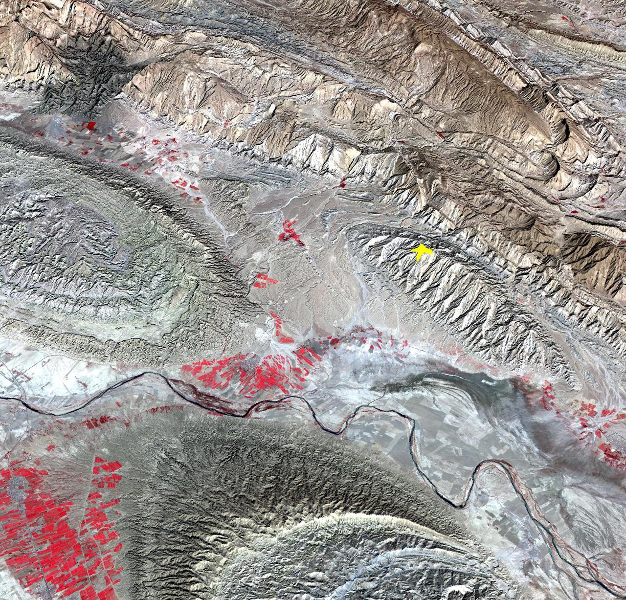
On April 9, 2013 at 11:52 GMT, a magnitude 6.3 earthquake hit southwestern Iran's Bushehr province near the town of Kaki. Preliminary information is that several villages have been destroyed and many people have died, as reported by BBC News. This perspective view of the region was acquired Nov. 17, 2012, by the Advanced Spaceborne Thermal Emission and Reflection Radiometer (ASTER) instrument on NASA's Terra spacecraft. The location of the earthquake's epicenter is marked with a yellow star. Vegetation is displayed in red; the vertical exaggeration of the topography is 2X. The image is centered near 28.5 degrees north latitude, 51.6 degrees east longitude. With its 14 spectral bands from the visible to the thermal infrared wavelength region and its high spatial resolution of 15 to 90 meters (about 50 to 300 feet), ASTER images Earth to map and monitor the changing surface of our planet. ASTER is one of five Earth-observing instruments launched Dec. 18, 1999, on Terra. The instrument was built by Japan's Ministry of Economy, Trade and Industry. A joint U.S./Japan science team is responsible for validation and calibration of the instrument and data products. The broad spectral coverage and high spectral resolution of ASTER provides scientists in numerous disciplines with critical information for surface mapping and monitoring of dynamic conditions and temporal change. Example applications are: monitoring glacial advances and retreats; monitoring potentially active volcanoes; identifying crop stress; determining cloud morphology and physical properties; wetlands evaluation; thermal pollution monitoring; coral reef degradation; surface temperature mapping of soils and geology; and measuring surface heat balance. The U.S. science team is located at NASA's Jet Propulsion Laboratory, Pasadena, Calif. The Terra mission is part of NASA's Science Mission Directorate, Washington, D.C. More information about ASTER is available at <a href="http://asterweb.jpl.nasa.gov/" rel="nofollow">asterweb.jpl.nasa.gov/</a>. Image Credit: NASA/GSFC/METI/ERSDAC/JAROS, and U.S./Japan ASTER Science Team Image Addition Date: 2013-04-10 <b><a href="http://www.nasa.gov/audience/formedia/features/MP_Photo_Guidelines.html" rel="nofollow">NASA image use policy.</a></b> <b><a href="http://www.nasa.gov/centers/goddard/home/index.html" rel="nofollow">NASA Goddard Space Flight Center</a></b> enables NASA’s mission through four scientific endeavors: Earth Science, Heliophysics, Solar System Exploration, and Astrophysics. Goddard plays a leading role in NASA’s accomplishments by contributing compelling scientific knowledge to advance the Agency’s mission. <b>Follow us on <a href="http://twitter.com/NASA_GoddardPix" rel="nofollow">Twitter</a></b> <b>Like us on <a href="http://www.facebook.com/pages/Greenbelt-MD/NASA-Goddard/395013845897?ref=tsd" rel="nofollow">Facebook</a></b> <b>Find us on <a href="http://instagram.com/nasagoddard?vm=grid" rel="nofollow">Instagram</a></b>