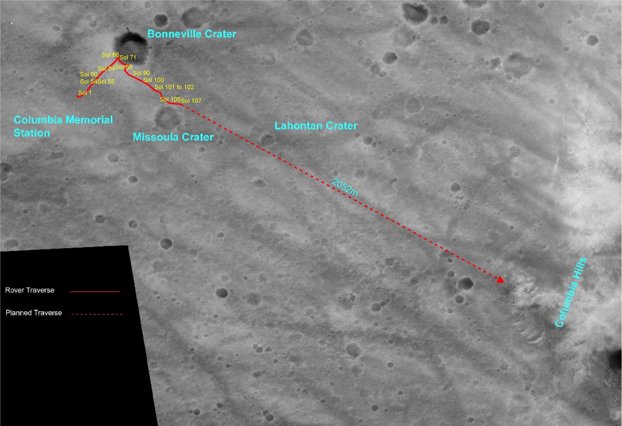
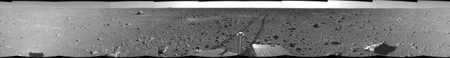
Spirit Travels
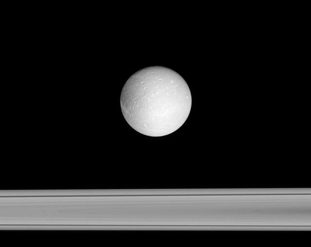
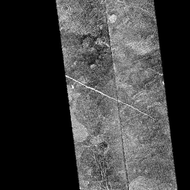
Icy Traveler
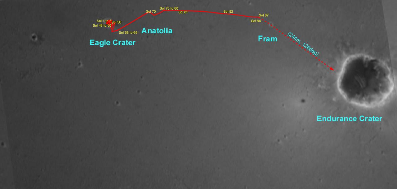
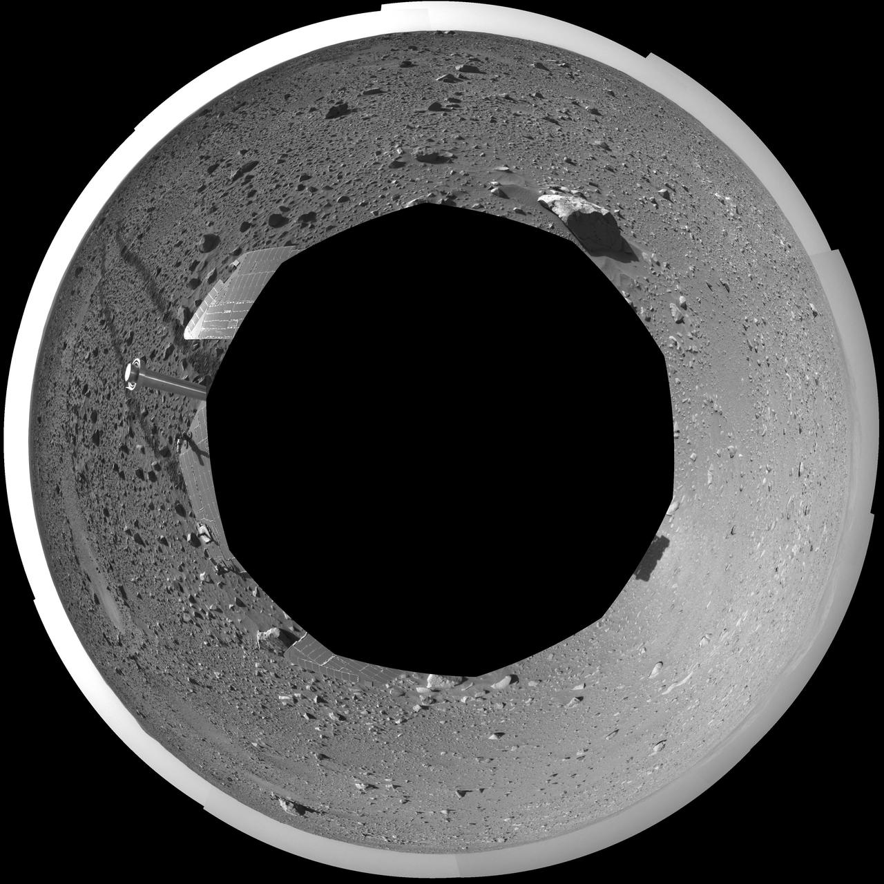
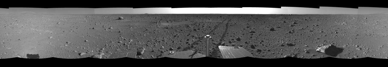
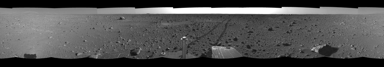
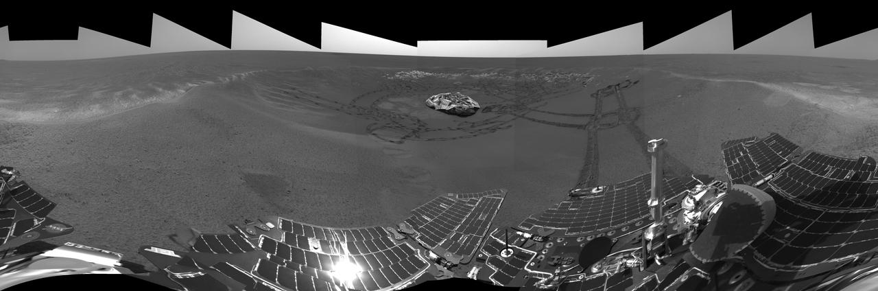
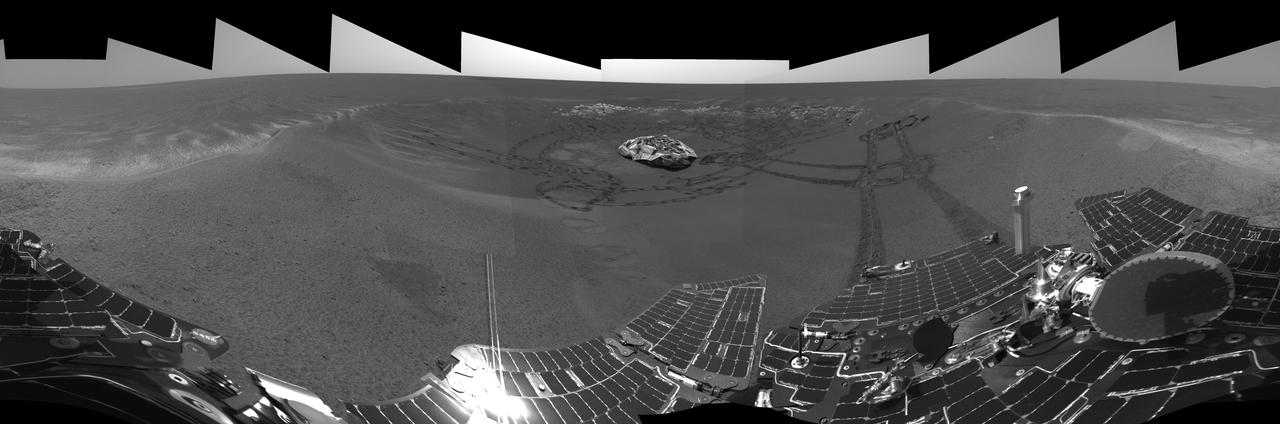
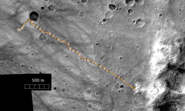
Opportunity Travels
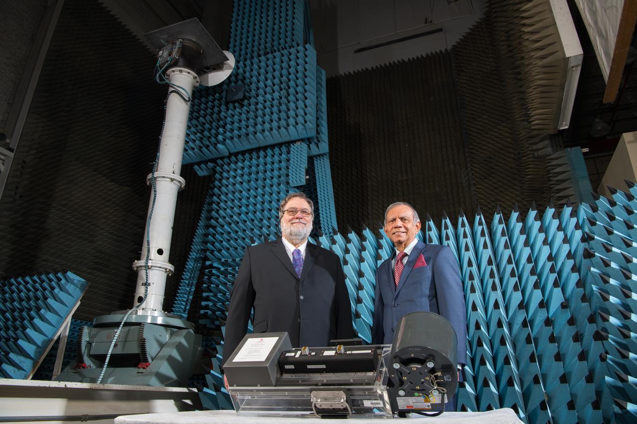
Traveling Wave Tube Amplifier,TWTA,

Traveling Wave Tube Amplifier,TWTA,
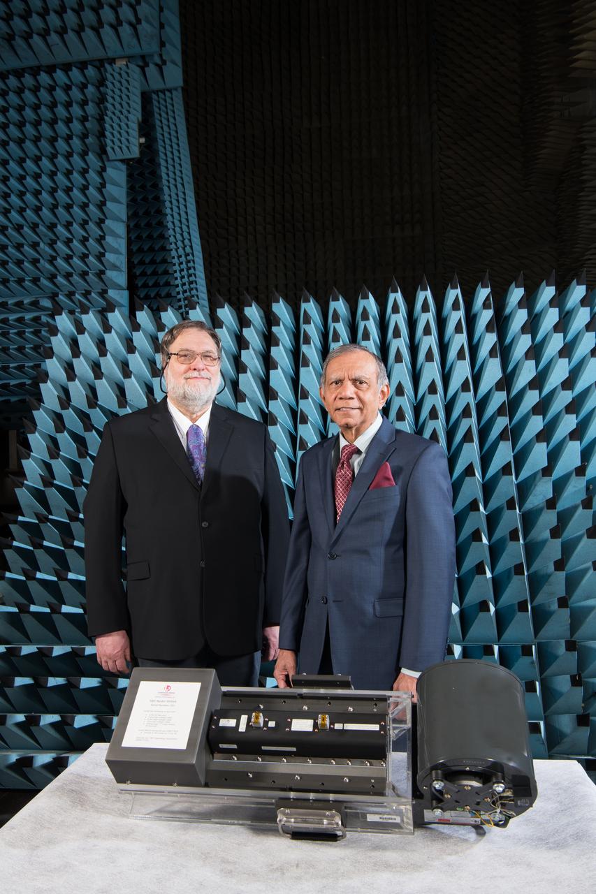
Traveling Wave Tube Amplifier,TWTA,
The Road Less Traveled polar
The Road Less Traveled
The Road Less Traveled
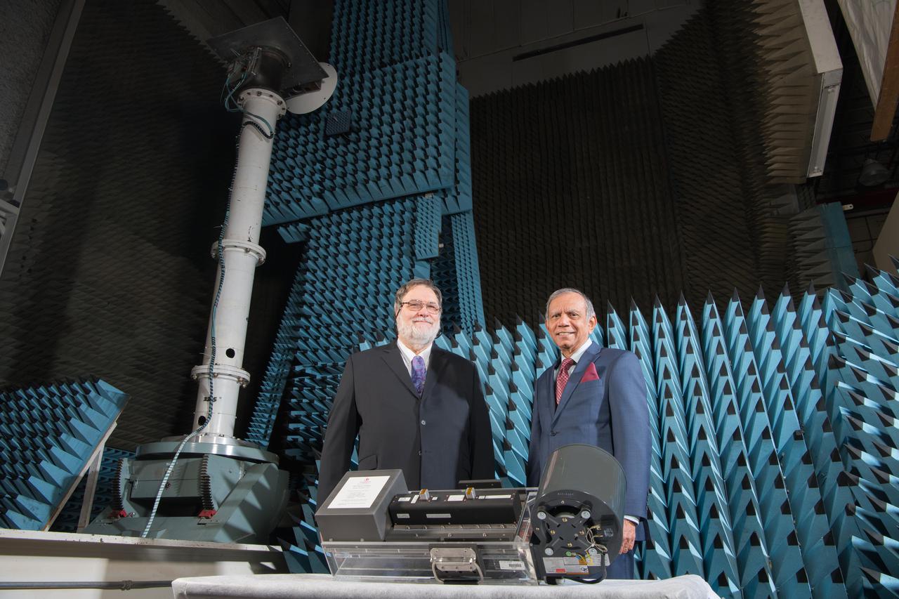
Traveling Wave Tube Amplifier,TWTA,
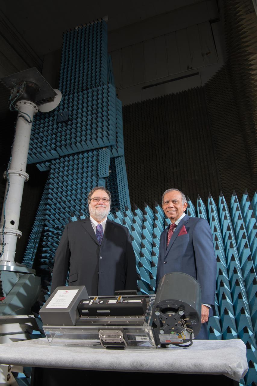
Traveling Wave Tube Amplifier,TWTA,
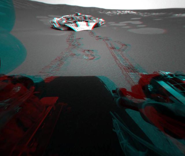
The Road Less Traveled left eye
The Road Less Traveled right eye
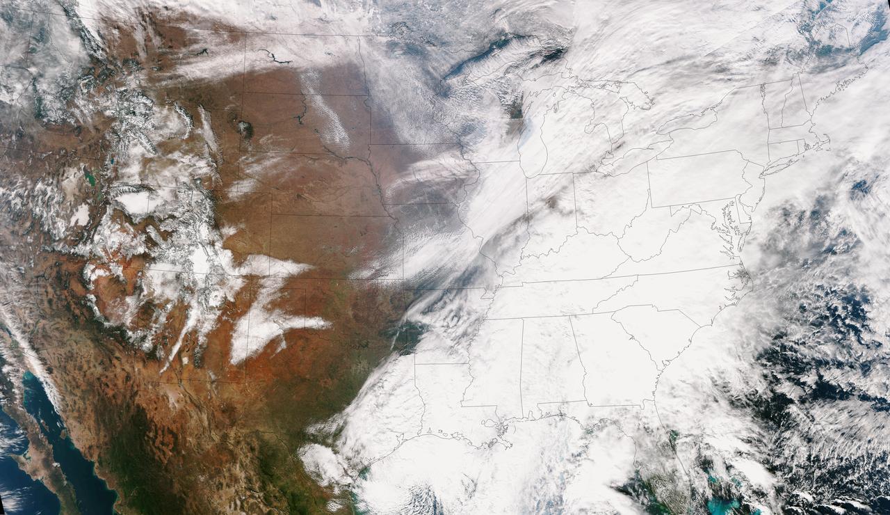
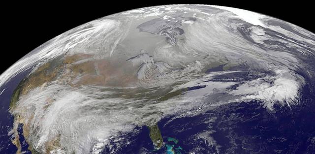
This true color image of the Continental United States was taken on Nov. 25, 2013 by the Suomi NPP satellite and shows the system as it moves through the South and Midwest. The National Weather Service noted that a complex and powerful storm system continues to generate widespread moderate to heavy rainfall and snows in various parts of the eastern United States as travelers make their way to destinations to celebrate Thanksgiving and Hanukkah on Nov. 28. There are two low-pressure areas working together. One was centered near New Jersey while the other was located over the Carolinas. From the Southeast to New England widespread moderate to heavy rainfall is expected. The rains will also affect the Mid-Atlantic and Southeastern United States, although those regions are not expected to get as much of a soaking. The Appalachians and interior New England are expected to receive snowfall. Areas of heavy snow are forecast for northwestern Indiana and northwestern Pennsylvania on Nov. 27. Snows will blanket the north central United States from the Dakotas to Minnesota, Iowa, Wisconsin, Michigan, the Ohio and Tennessee Valleys, upstate New York and parts of northern New England. The National Weather Service noted that cold air is moving in behind the storm and drop temperatures along the eastern U.S. making for a chilly Thanksgiving. Credit: NASA/NOAA <b><a href="http://www.nasa.gov/audience/formedia/features/MP_Photo_Guidelines.html" rel="nofollow">NASA image use policy.</a></b> <b><a href="http://www.nasa.gov/centers/goddard/home/index.html" rel="nofollow">NASA Goddard Space Flight Center</a></b> enables NASA’s mission through four scientific endeavors: Earth Science, Heliophysics, Solar System Exploration, and Astrophysics. Goddard plays a leading role in NASA’s accomplishments by contributing compelling scientific knowledge to advance the Agency’s mission. <b>Follow us on <a href="http://twitter.com/NASA_GoddardPix" rel="nofollow">Twitter</a></b> <b>Like us on <a href="http://www.facebook.com/pages/Greenbelt-MD/NASA-Goddard/395013845897?ref=tsd" rel="nofollow">Facebook</a></b> <b>Find us on <a href="http://instagram.com/nasagoddard?vm=grid" rel="nofollow">Instagram</a></b>
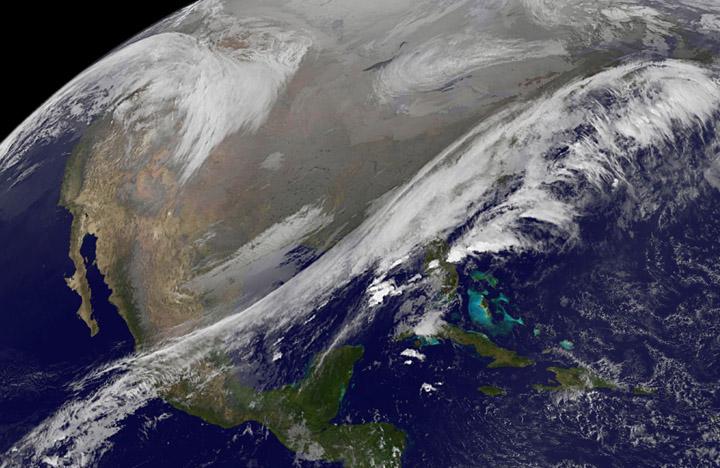
This NOAA's GOES satellite infrared image taken on Nov. 25 at 11:45 UTC (6:45 a.m. EST) shows two main weather systems over the U.S. Credit: NASA/NOAA GOES Project As the U.S. Thanksgiving holiday approaches this Thursday, November 27, NOAA's GOES-East and GOES-West satellites are keeping a weather eye out for storms that may affect early travelers. In an image from Nov. 25, the satellites show an active weather pattern is in place for travelers across the central and eastern U.S. NOAA's GOES-East satellite provides visible and infrared images over the eastern U.S. and the Atlantic Ocean, while NOAA's GOES-West satellite covers the western U.S. and Pacific Ocean from its fixed orbit in space. Data from both satellites were combined at NASA's GOES Project to create a full view of the U.S. on Nov. 25 at 11:45 UTC (6:45 a.m. EST). The image shows clouds associated with cold front stretching from the Gulf of Mexico over northern Florida and along the U.S. East coast to eastern Canada. Clouds associated with another area of low pressure are in the northern Rockies and northwestern U.S. To create the image, NASA/NOAA's GOES Project takes the cloud data from NOAA's GOES-East satellite and overlays it on a true-color image of land and ocean created by data from the Moderate Resolution Imaging Spectroradiometer, or MODIS, instrument that flies aboard NASA's Aqua and Terra satellites. Together, those data created the entire picture of the storm and show its movement. After the storm system passes, the snow on the ground becomes visible. NOAA's National Weather Service Weather Prediction Center said "a storm system will develop off the coast of the Carolinas early Wednesday (Nov. 25) and strengthen as it moves rapidly up the East Coast Wednesday into early Thursday (Nov. 26). Heavy snow is likely to begin in the central Appalachians early Wednesday morning, spreading northeast through the interior Mid-Atlantic into New England by Wednesday night. Winter Storm Watches are in effect for these areas." For travelers in the western U.S., the Northern Rocky Mountains are expected to receive more snow from the north side of a stationary frontal boundary. South of the boundary rain showers will affect the lower valley. The National Weather Service calls for cold weather to continue in the northern Plains and Upper Midwest as a Canadian surface high pressure rules the weather. The U.S. Southwest will experience nice weather for mid-week. In the Pacific Northwest, the National Weather Service noted that a warm front will bring rain, heavy at times, to the Cascades today and tonight. There will be a break in the heavier rains on Wednesday, then another period of heavy rain for the Cascades Wednesday night through Friday morning as a cold front slowly drags through the area. NOAA's GOES satellites provide the kind of continuous monitoring necessary for intensive data analysis. Geostationary describes an orbit in which a satellite is always in the same position with respect to the rotating Earth. This allows GOES to hover continuously over one position on Earth's surface, appearing stationary. As a result, GOES provide a constant vigil for the atmospheric triggers for severe weather conditions such as tornadoes, flash floods, hail storms and hurricanes.
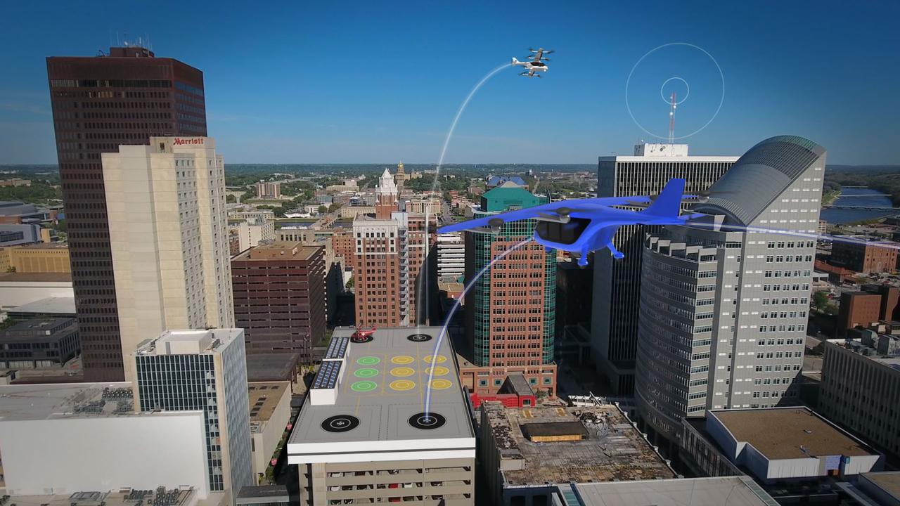
Several projects supporting NASA's Advanced Air Mobility, or AAM mission, are working on different elements to help make AAM a reality. The team is researching how the addition of AAM could cut traffic commutes, make travel more sustainable, and make road trips shorter. With the addition of AAM, we would be using another dimension in the sky for travel below traditional aircraft and above cars, buses, or trains below.
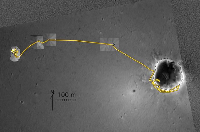
A Well-Traveled Eagle Crater right-eye
A Well-Traveled Eagle Crater left-eye
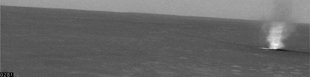
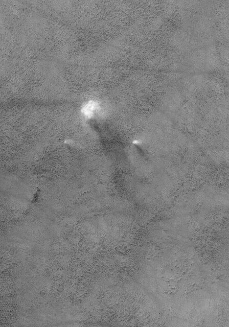
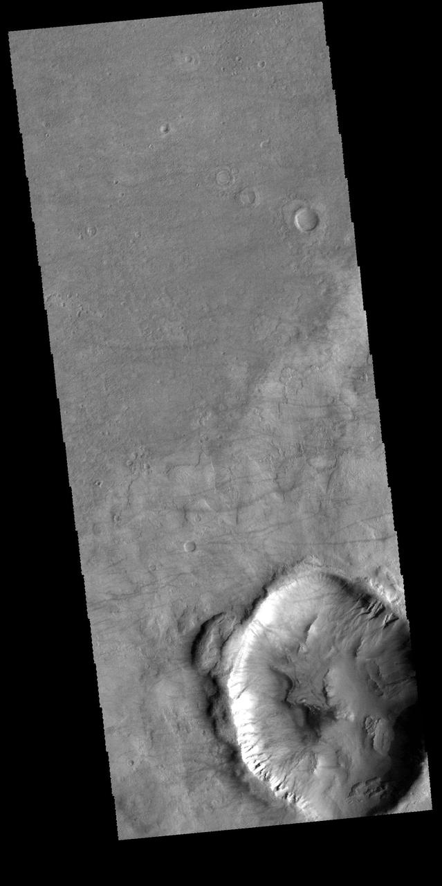
Wind-Driven Traveler on Mars Spirit Sol 486
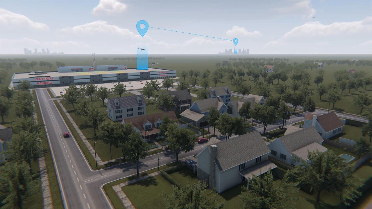
Advanced Air Mobility will connect both urban dwellers and rural residents by adding a new way to travel by air. As shown in this concept art, passengers could travel from rural areas into the city quicker than by car to board a commercial airliner, access medical care or to purchase goods.
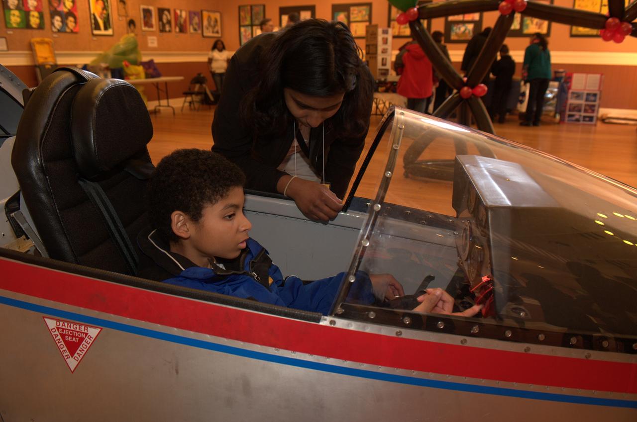
10th Anniversary of Reachout for the Rainbow after School Science Festival highlighting NASA Ames and the Traveling Space Museum exhibits and activities at the South San Francisco Bayview Opera House. Stephen Horsley gets a close up look at the cockpit of one the models provided by the Traveling Space Museum (TCS). photo release on file
By the end of the 19th century, soldiers, sailors, and practical and not-so practical inventors, had developed a stake in rocketry. Skillful theorists, like Konstantian Tsiolkovsky in Russia, were examining the fundamental scientific theories behind rocketry. They were begirning to consider the possibility of space travel
This MOC image shows a dust devil traveling across a plain west-southwest of Schiaparelli Crater, in far eastern Sinus Meridiani. The dust devil is casting a shadow toward the northeast, just south below of an egg-shaped crater
Less interested in the scientific fundamentals of rocketry, many writers of popular literature and science fiction discovered one of the most vital elements in the formula for space travel, a fertile imagination. Under the impression that the sun "draws up" dewdrops, Cyrano de Bergerac suggested fancifully that one might fly by trapping dew in bottles, strapping the bottles to oneself, and standing in sunlight.
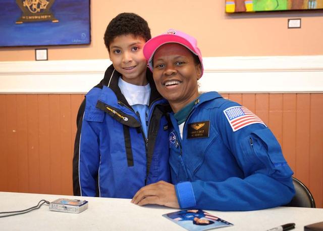
10th Anniversary of Reachout for the Rainbow after School Science Festival highlighting NASA Ames and the Traveling Space Museum exhibits and activities at the South San Francisco Bayview Opera House. NASA Astronaut Yvonne Cagle signing autographs after speaking at event, shown here with Stephen Horsley. photo release on file
Spirit Travels During its First 238 Martian Days
Opportunity Travels During its First 205 Martian Days
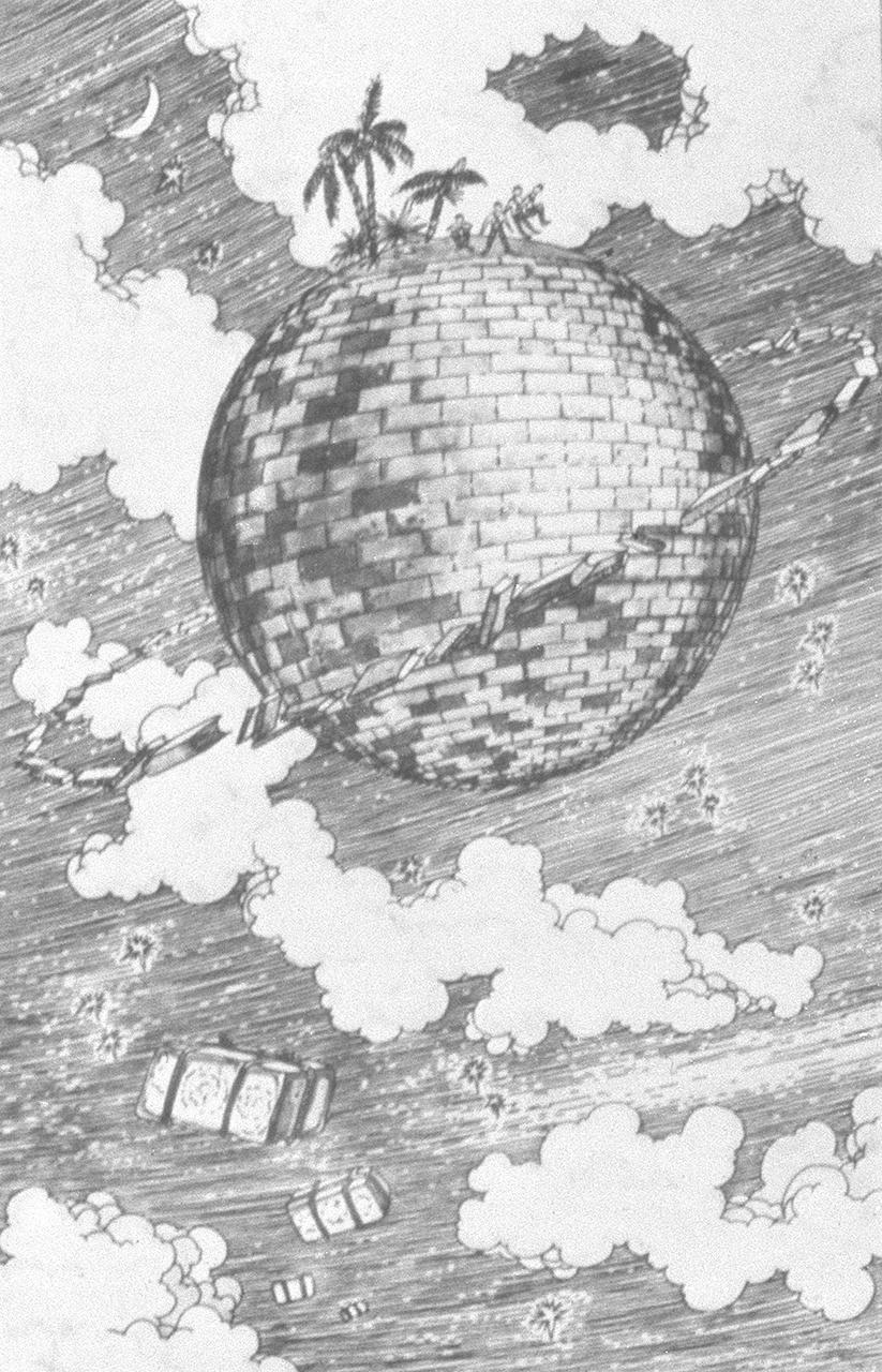
Science fiction writers, like Jules Verne in France and Edward Everett Hale in America, had discovered one of the most vital elements in the formula for space travel-a fertile imagination. The first known proposal for a marned-satellite appears in a story by Hale entitled "The Brick Moon" published in 1899. The story involved a group of young Bostonians who planned to put an artificial satellite into polar orbit for sailors to use to determine longitude accurately and easily. They planned to send a brick satellite into orbit because the satellite would have to withstand fire very well. The Satellite's 37 inhabitants signaled the Earth in morse code by jumping up and down on the outside of the satellite.
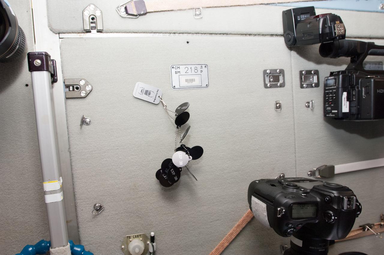
View of geocaching travel bug attached to chain,in the Service Module (SM) - (Panel 218). Photo was taken during Expedition 38. Image was released by astronaut on Twitter.
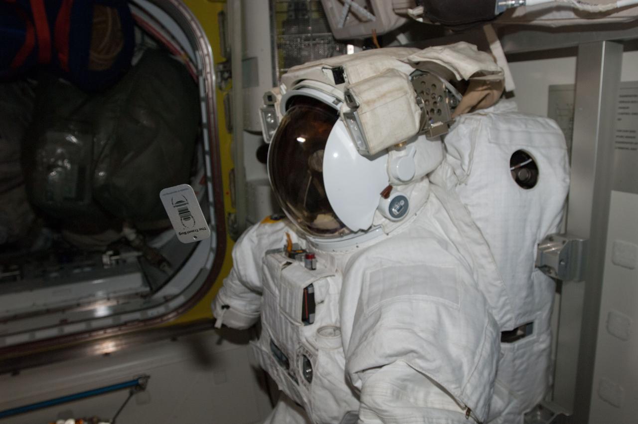
View of Extravehicular Mobility Unit (EMU) with geocaching travel bug,in the airlock (A/L). Photo was taken during Expedition 38. Image was released by astronaut on Twitter.

An idea for a future air taxi hovers over a municipal vertiport in this NASA illustration. Experts from NASA’s Advanced Air Mobility mission have signed agreements with four states and one city to host a series of workshops that will help local governments prepare their transportation plans to include this new form of air travel.
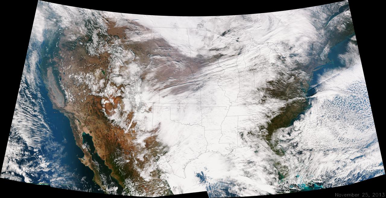
A large winter system is moving across the United States and is combining with cold air moving down from Canada, bringing snow to some areas. Major travel impacts are expected along the main highways throughout the eastern U.S. This true color image of the Continental U.S. was taken on November 25, 2013 by the Suomi NPP satellite and shows the system as it moves through the South and Midwest. <b><a href="http://www.nasa.gov/audience/formedia/features/MP_Photo_Guidelines.html" rel="nofollow">NASA image use policy.</a></b> <b><a href="http://www.nasa.gov/centers/goddard/home/index.html" rel="nofollow">NASA Goddard Space Flight Center</a></b> enables NASA’s mission through four scientific endeavors: Earth Science, Heliophysics, Solar System Exploration, and Astrophysics. Goddard plays a leading role in NASA’s accomplishments by contributing compelling scientific knowledge to advance the Agency’s mission. <b>Follow us on <a href="http://twitter.com/NASA_GoddardPix" rel="nofollow">Twitter</a></b> <b>Like us on <a href="http://www.facebook.com/pages/Greenbelt-MD/NASA-Goddard/395013845897?ref=tsd" rel="nofollow">Facebook</a></b> <b>Find us on <a href="http://instagrid.me/nasagoddard/?vm=grid" rel="nofollow">Instagram</a></b>
This MOC image shows a large dust devil flanked by two relatively small dust devils, moving together across a lightly-dusted, south high-latitude plain
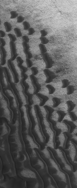
This Mars Global Surveyor MOC image shows dark dunes superposed on the rippled floor of Proctor Crater in Noachis Terra. Winds blowing predominantly from east right to west left were responsible for the formation of these dunes
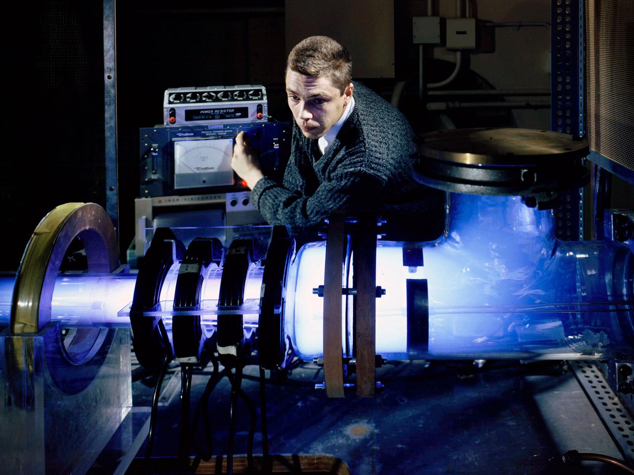
Raymond Palmer, of the Electromagnetic Propulsion Division’s Plasma Flow Section, adjusts the traveling magnetic wave plasma engine being operated in the Electric Power Conversion at the National Aeronautics and Space Administration (NASA) Lewis Research Center. During the 1960s Lewis researchers were exploring several different methods of creating electric propulsion systems, including the traveling magnetic wave plasma engine. The device operated similarly to alternating-current motors, except that a gas, not a solid, was used to conduct the electricity. A magnetic wave induced a current as it passed through the plasma. The current and magnetic field pushed the plasma in one direction. Palmer and colleague Robert Jones explored a variety of engine configurations in the Electric Propulsion Research Building. The engine is seen here mounted externally on the facility’s 5-foot diameter and 16-foot long vacuum tank. The four magnetic coils are seen on the left end of the engine. The researchers conducted two-minute test runs with varying configurations and used of both argon and xenon as the propellant. The Electric Propulsion Research Building was built in 1942 as the Engine Propeller Research Building, often called the Prop House. It contained four test cells to study large reciprocating engines with their propellers. After World War II, the facility was modified to study turbojet engines. By the 1960s, the facility was modified again for electric propulsion research and given its current name.
This frame from a movie presents a series of animations showing NASA Dawn spacecraft traveling to and operating at the giant asteroid Vesta.
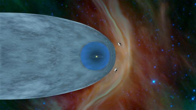
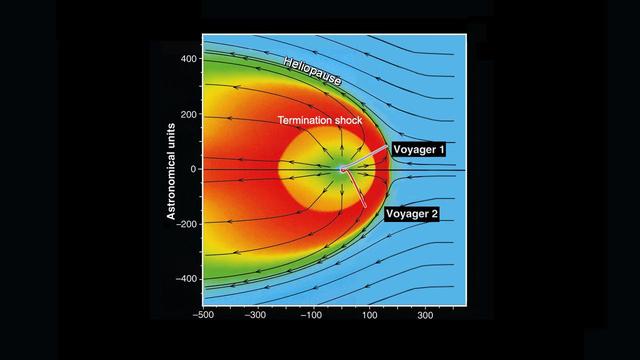
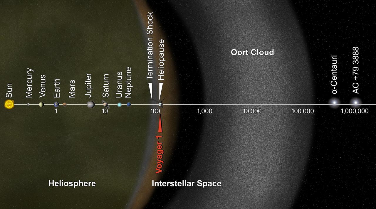
This illustration shows the position of NASA's Voyager 1 and Voyager 2 probes, outside of the heliosphere, a protective bubble created by the Sun that extends well past the orbit of Pluto. Voyager 1 crossed the heliopause, or the edge of the heliosphere, in August 2012. Heading in a different direction, Voyager 2 crossed another part of the heliopause in November 2018. https://photojournal.jpl.nasa.gov/catalog/PIA22835
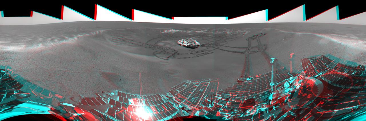
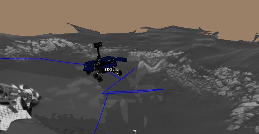
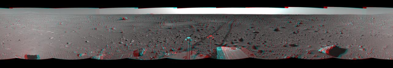
This is the 3-D version of NASA Mars Exploration Rover Opportunity view on its 56th sol on Mars, before it left Eagle Crater. 3D glasses are necessary to view this image.
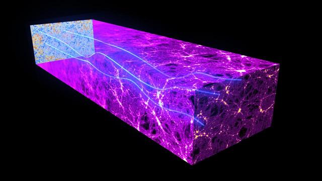
This artist impression shows how photons from the early universe are deflected by the gravitational lensing effect of massive cosmic structures as they travel across the universe.
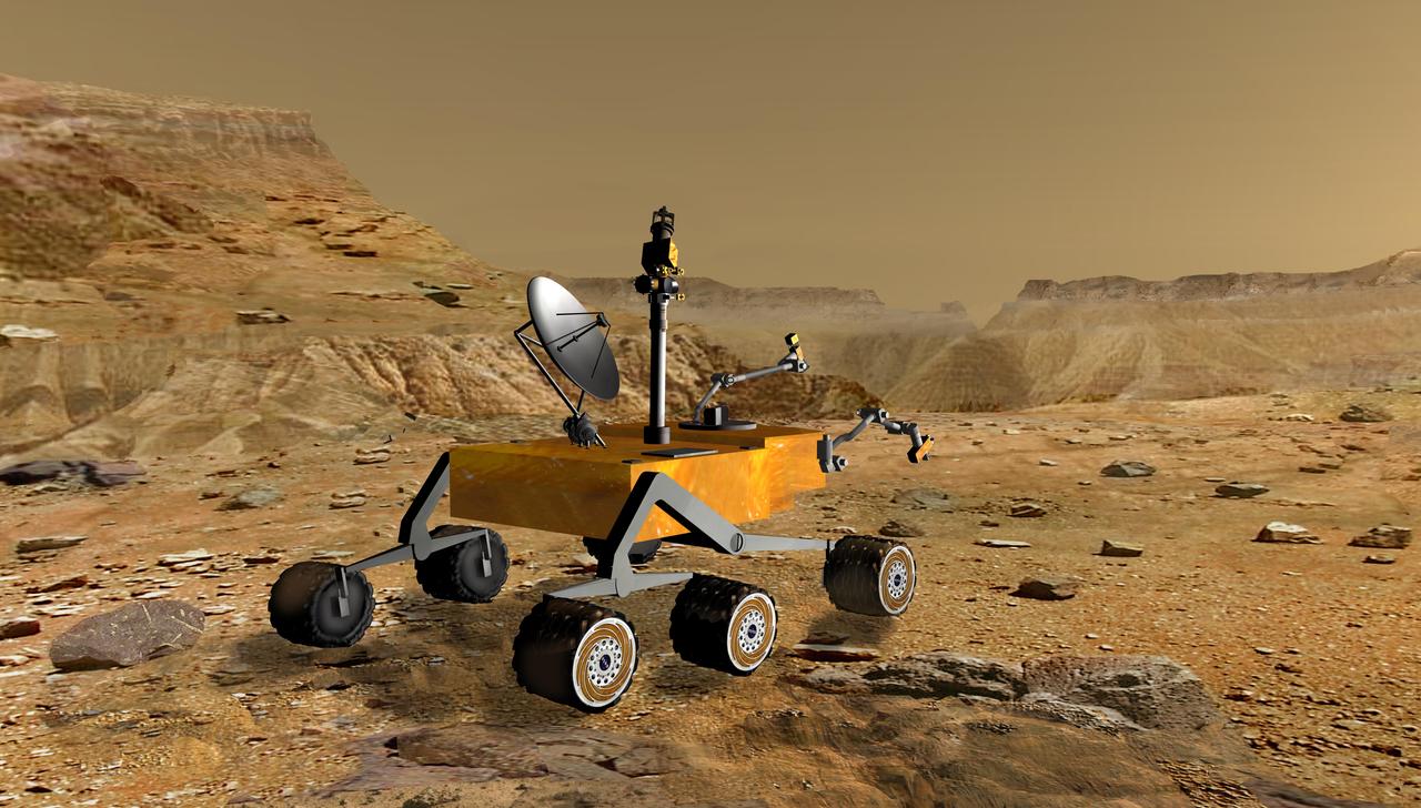
NASA Mars Science Laboratory travels near a canyon on Mars in this artist concept. The mission is under development for launch in 2009 and a precision landing on Mars in 2010.
This frame from an artist animation depicts the life of a photon, or particle of light, as it travels across space and time, from the very early universe ESA Planck satellite.
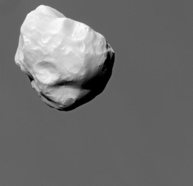
Although travelling at great speed, NASA Cassini spacecraft managed to capture this close view of Saturn small moon Helene during a flyby on March 3, 2010.

After NASA Phoenix Mars Lander enters the Martian atmosphere, and is traveling at about 1.7 times the speed of sound, it will deploy its parachute.

AS17-148-22727 (7 Dec. 1972) --- This view of Earth was seen by the Apollo 17 crew as they traveled toward the moon on their NASA lunar landing mission. This outstanding trans-lunar coast photograph extends from the Mediterranean Sea area to the Antarctica south polar ice cap. This is the first time the Apollo trajectory made it possible to photograph the south polar ice cap. Note the heavy cloud cover in the Southern Hemisphere. Almost the entire coastline of Africa is clearly visible. The Arabian Peninsula can be seen at the northeastern edge of Africa. The large island off the coast of Africa is the Malagasy Republic. The Asian mainland is on the horizon toward the northeast. The Apollo 17 crew consisted of astronauts Eugene A. Cernan, mission commander; Ronald E. Evans, command module pilot; and Harrison H. Schmitt, lunar module pilot. While astronauts Cernan and Schmitt descended in the Lunar Module (LM) to explore the moon, astronaut Evans remained with the Command and Service Modules (CSM) in lunar orbit.
After traveling more than 1.5 billion kilometers 948 million miles, NASA Magellan spacecraft was inserted into orbit around Venus on Aug. 10, 1990. http://photojournal.jpl.nasa.gov/catalog/PIA00205
This 3-D cylindrical-perspective mosaic was created from navigation camera images that NASA Mars Exploration Rover Spirit captured on on sol 127. 3D glasses are necessary to view this image.
This schematic shows our solar bubble moving through nearby interstellar space, or the space between stars.
This map shows the route driven by NASA Mars rover Curiosity through the 56th Martian day, or sol, of the rover mission on Mars Oct. 2, 2012.
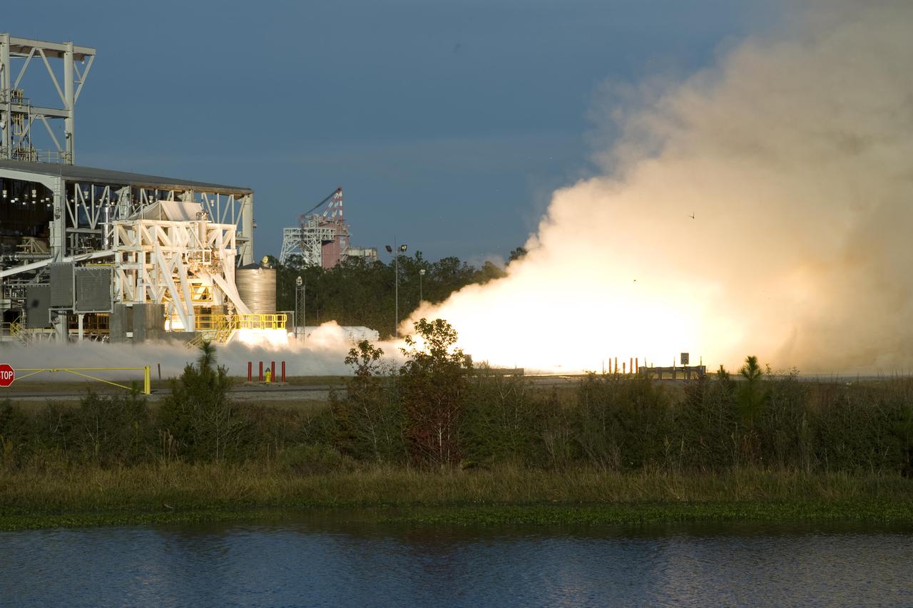
Fire and steam signal a successful test firing of Orbital Sciences Corporation's Aerojet AJ26 rocket engine at John C. Stennis Space Center. AJ26 engines will be used to power Orbital's Taurus II space vehicle on commercial cargo flights to the International Space Station. On Nov. 10, operators at Stennis' E-1 Test Stand conducted a 10-second test fire of the engine, the first of a series of three verification tests. Orbital has partnered with NASA to provide eight missions to the ISS by 2015.
On November 23, 2013 at at 2045 UTC/3:45 p.m. EST, Arctic air pours over North America during the week before Thanksgiving, bringing several days of unseasonal freezing temperatures and difficult weather to the United States. Credit: NASA GOES Project/Dennis Chesters <b><a href="http://www.nasa.gov/audience/formedia/features/MP_Photo_Guidelines.html" rel="nofollow">NASA image use policy.</a></b> <b><a href="http://www.nasa.gov/centers/goddard/home/index.html" rel="nofollow">NASA Goddard Space Flight Center</a></b> enables NASA’s mission through four scientific endeavors: Earth Science, Heliophysics, Solar System Exploration, and Astrophysics. Goddard plays a leading role in NASA’s accomplishments by contributing compelling scientific knowledge to advance the Agency’s mission. <b>Follow us on <a href="http://twitter.com/NASA_GoddardPix" rel="nofollow">Twitter</a></b> <b>Like us on <a href="http://www.facebook.com/pages/Greenbelt-MD/NASA-Goddard/395013845897?ref=tsd" rel="nofollow">Facebook</a></b> <b>Find us on <a href="http://instagrid.me/nasagoddard/?vm=grid" rel="nofollow">Instagram</a></b>
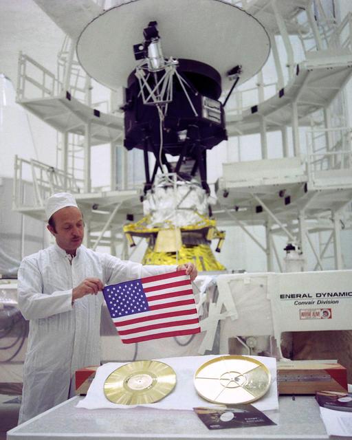
As NASA two Voyager spacecraft travel out into deep space, they carry a small American flag and a Golden Record packed with pictures and sounds -- mementos of our home planet.

Tones represents sound waves that traveled through the early universe, and were later heard by ESA Planck space telescope. The primordial sound waves have been translated into frequencies we can hear.
This image taken by NASA Mars Odyssey spacecraft shows a portion of Maunder Crater with a number of interesting features including a series of barchan dunes that are traveling from right to left and gullies.
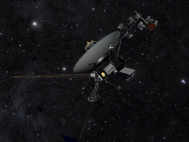
This artist concept shows NASA Voyager spacecraft against a field of stars in the darkness of space as they travel farther away from Earth, on a journey to interstellar space, and will eventually circle around the center of the Milky Way galaxy.

A brilliant spot of sunlight, the opposition effect, travels outward across the rings as the Cassini spacecraft orbits Saturn. This surge in ring brightness is created around the point directly opposite the Sun from the spacecraft
This image maps out the travels of NASA Mars Exploration Rover Opportunity, from is landing site at Eagle Crater to the rim of Victoria Crater about six miles 9.7 kilometers away in September of 2006.

Following the path of one of Jupiter jet streams, a line of v-shaped chevrons travels west to east just above Jupiter Great Red Spot as seen by NASA Cassini spacecraft.
On April 15, 2010, NASA Terra spacecraft captured these images of the ongoing eruption of Iceland Eyjafjallajökull Volcano, which continues to spew ash into the atmosphere and impact air travel worldwide.

This is an image from NASA Spitzer Space Telescope of stars and galaxies in the Ursa Major constellation. This infrared image covers a region of space so large that light would take up to 100 million years to travel across it.
At right, NASA Sojourner has traveled off the lander rear ramp and onto the surface of Mars. The rock Barnacle Bill and the rear ramp is to the left of Sojourner. 3D glasses are necessary to identify surface detail.
Voyager 1 has entered interstellar space. NASA spacecraft, which rose from Earth on a September morning 36 years ago, has traveled farther than anyone, or anything, in history.
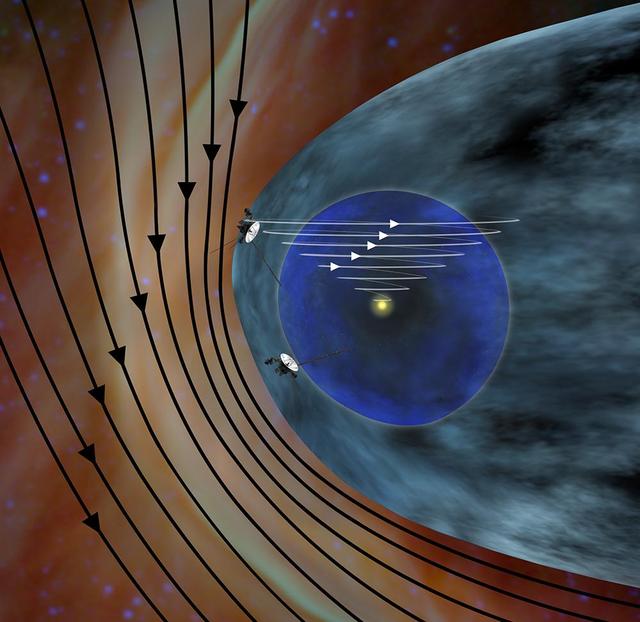
This artist concept shows the different expected directions of the magnetic fields in interstellar space black lines and the magnetic field emanating from our sun white lines as NASA Voyager 1 spacecraft travels northward out of the heliosphere.
This image is from an animation that chronicles the travels of NASA Deep Impact spacecraft, from its launch in January of 2005 to its dramatic impact 172 days later with comet Tempel 1.
New data from NASA Cassini spacecraft suggest that the shape of our solar system moving through the local Milky Way galaxy looks like a bubble -- or a rat -- traveling through a boa constrictor belly.
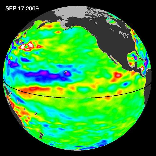
Pools of warm water known as Kelvin waves can be seen traveling eastward along the equator black line in this image from the NASA/French Space Agency Ocean Surface Topography Mission/Jason-2 satellite.
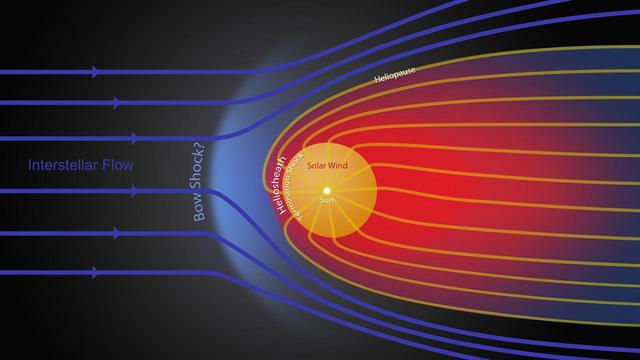
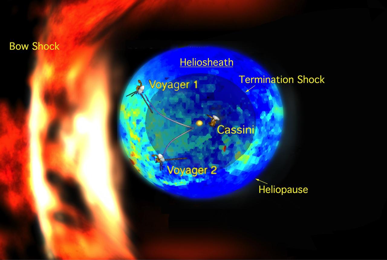
This graphic shows the different streams of charged particles inside the bubble around our sun and outside, in the unexplored territory of interstellar space. The heliosheath, where NASA two Voyager spacecraft are now traveling, is shown in red.

The Advanced Space Transportation Group takes the future of space travel far into the 21st Century. Pictured is an artist's concept of a third generation Reusable Launch Vehicle (RLV). Projected for the year 2025, this third generation RLV will introduce an era of space travel not unlike air travel today.
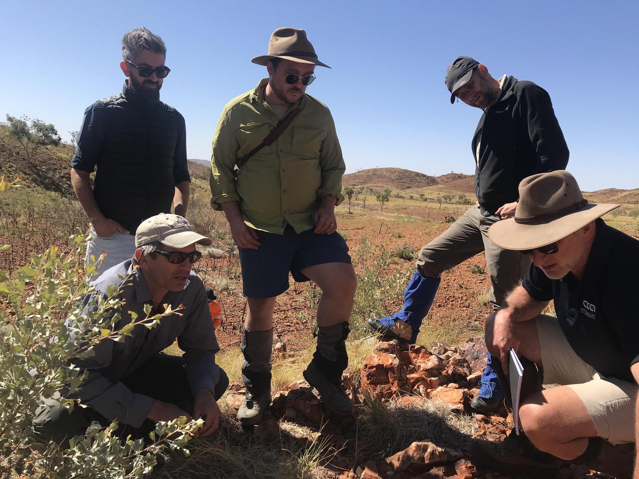
Scientists with NASA's Mars 2020 mission and the European-Russian ExoMars mission traveled to the Australian Outback to hone their research techniques before their missions launch to the Red Planet in the summer of 2020. The trip was designed to help them better understand how to search for signs of ancient life on Mars. https://photojournal.jpl.nasa.gov/catalog/PIA23275
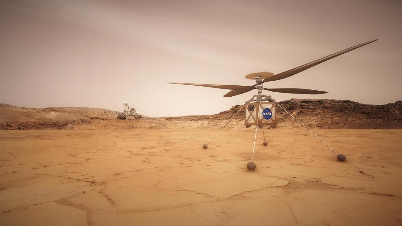
This artist concept shows the Mars Helicopter, a small, autonomous rotorcraft, which will travel with NASA's Mars 2020 rover mission, currently scheduled to launch in July 2020, to demonstrate the viability and potential of heavier-than-air vehicles on the Red Planet. https://photojournal.jpl.nasa.gov/catalog/PIA22460
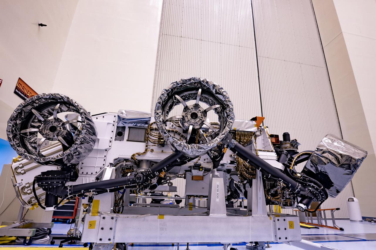
Three of the six flight wheels that will travel to Mars can be seen attached to NASA's Perseverance rover (which is inverted on a handling fixture) on March 30, 2020 at the Kennedy Space Center in Florida. The protective antistatic foil covering the wheels will be removed before launch; the launch window opens July 17, 2020. https://photojournal.jpl.nasa.gov/catalog/PIA23821
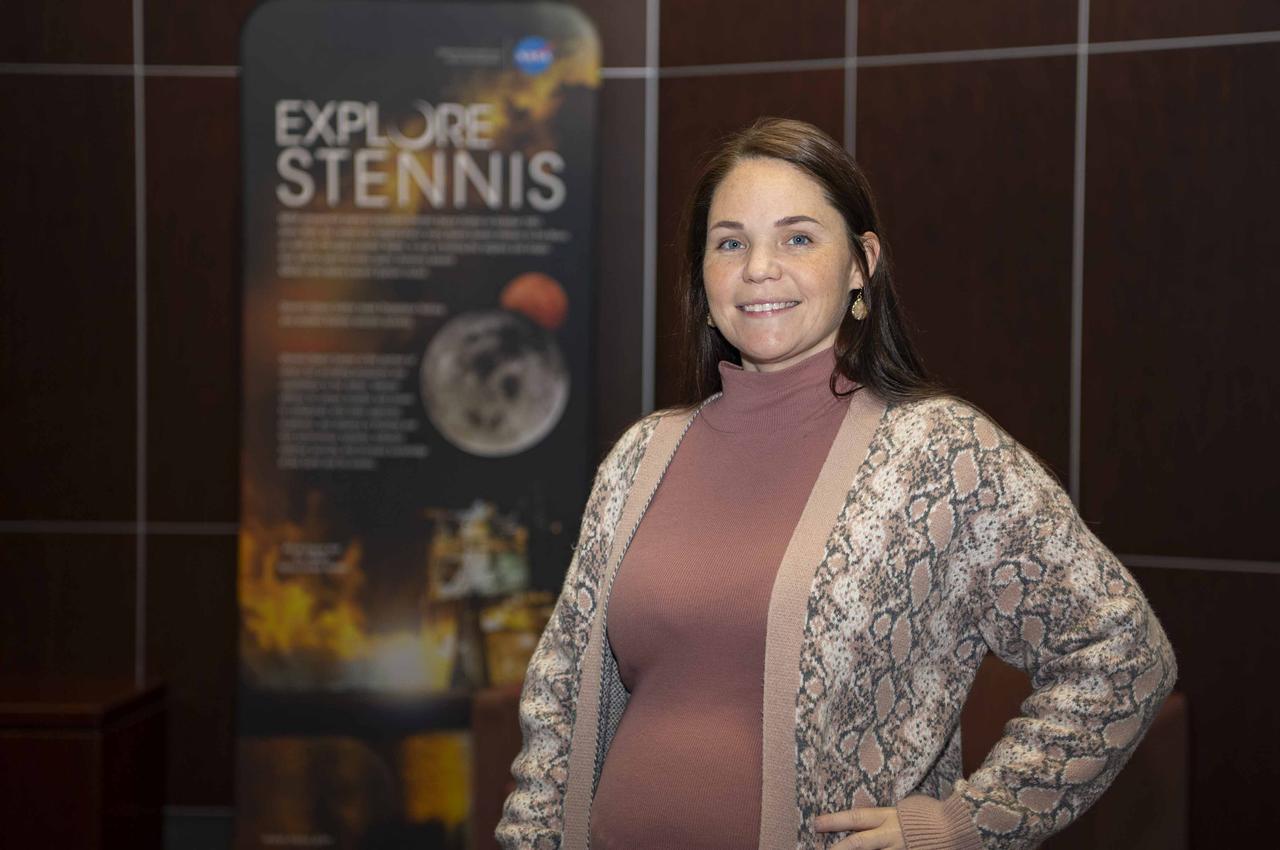
Heather Seagren grew up near NASA’s Stennis Space Center and visited for field trips as a child. Now, as a financial management specialist, Seagren coordinates work trips for NASA employees at the south Mississippi NASA center.
NASA Mars Exploration Rover Spirit used its rear hazard avoidance camera to take this view toward the south during the 1,899th Martian day, or sol, of Spirit mission on Mars May 6, 2009.

art002e024232 (April 6, 2026) - This photo of the Moon was captured by the Artemis II crew aboard the Orion spacecraft a few hours before the lunar flyby. During the flyby, the crew captured critical science observations as they traveled around the farside of the Moon, traveling farther than any humans ever before.
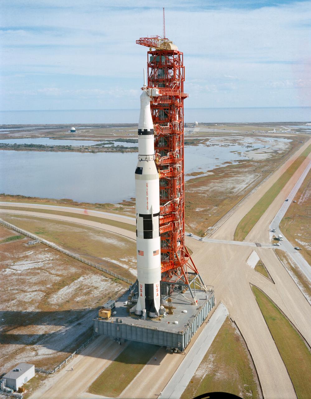
S70-54127 (9 Nov. 1970) --- A high-angle view at Launch Complex 39, Kennedy Space Center (KSC), showing the Apollo 14 (Spacecraft 110/Lunar Module 8/Saturn 509) space vehicle on the way from the Vehicle Assembly Building (VAB) to Pad A. The Saturn V stack and its mobile launch tower sit atop a huge crawler-transporter. The Apollo 14 crewmen will be astronauts Alan B. Shepard Jr., commander; Stuart A. Roosa, command module pilot; and Edgar D. Mitchell, lunar module pilot.
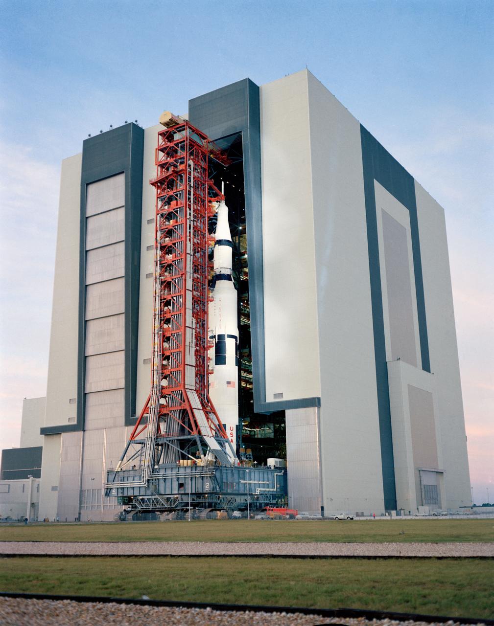
S70-54121 (9 Nov. 1970) --- A ground level view at Launch Complex 39, Kennedy Space Center (KSC), showing the Apollo 14 (Spacecraft 110/Lunar Module 8/Saturn 509) space vehicle leaving the Vehicle Assembly Building (VAB). The Saturn V stack and its mobile launch tower, atop a huge crawler-transporter, were rolled out to Pad A. The Apollo 14 crewmen will be astronauts Alan B. Shepard Jr., commander; Stuart A. Roosa, command module pilot; and Edgar D. Mitchell, lunar module pilot.
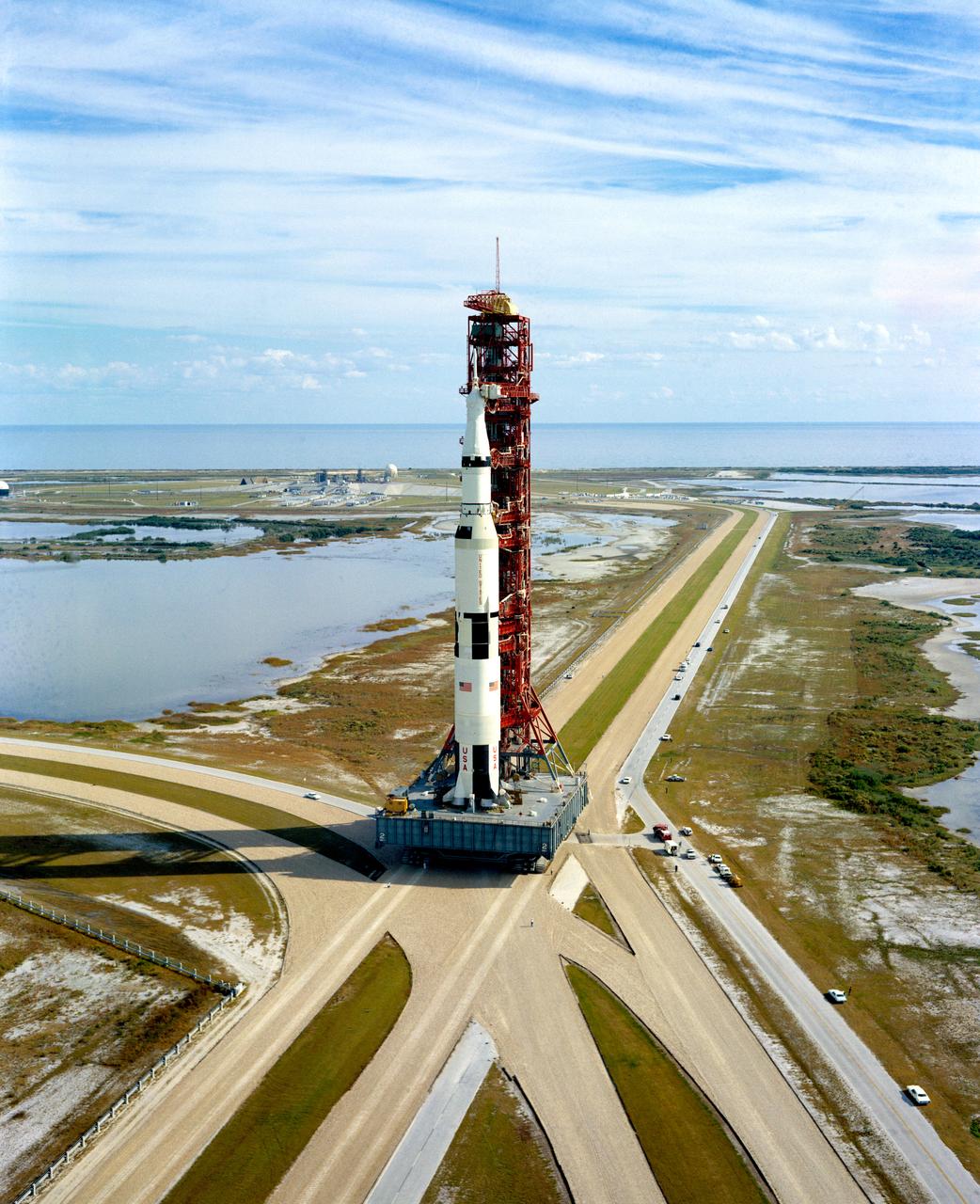
S70-54119 (9 Nov. 1970) --- A high-angle view at Launch Complex 39, Kennedy Space Center (KSC), showing the Apollo 14 (Spacecraft 110/Lunar Module 8/Saturn 509) space vehicle on the way from the Vehicle Assembly Building (VAB) to Pad A. The Saturn V stack and its mobile launch tower sit atop a huge crawler-transporter. The Apollo 14 crewmen will be astronauts Alan B. Shepard Jr., commander; Stuart A. Roosa, command module pilot; and Edgar D. Mitchell, lunar module pilot.
From on high, the Cassini spacecraft spies a group of three ring moons in their travels around Saturn. Janus is seen at top, while Pandora hugs the outer edge of the narrow F ring. More difficult to spot is Pan, which is a mere speck in this view.
The X-59 team working on the aircraft’s wiring around the engine inlet prior to the engine being installed. Once complete, the X-59 is designed to fly supersonic while reducing the loud sonic boom. The Quesst mission could help change the rules for commercial supersonic air travel over land.
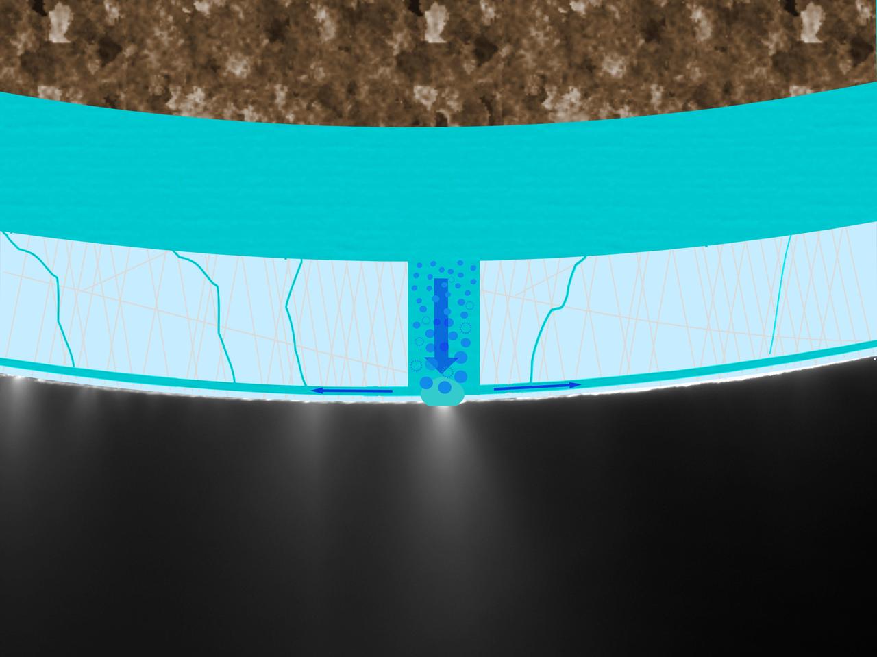
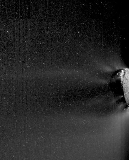
A graphic laid atop an image of Enceladus jets taken by NASA Cassini imaging cameras shows bubbles in seawater traveling through a passage in the ice crust to feed a geyser. Seawater flows back down to the subsurface ocean through cracks in the ice.
Images obtained by NASA EPOXI mission spacecraft show an active end of the nucleus of comet Hartley 2. Icy particles spew from the surface. Most of these particles are traveling with the nucleus; fluffy nowballs about 3 centimeters to 30 centimeters.
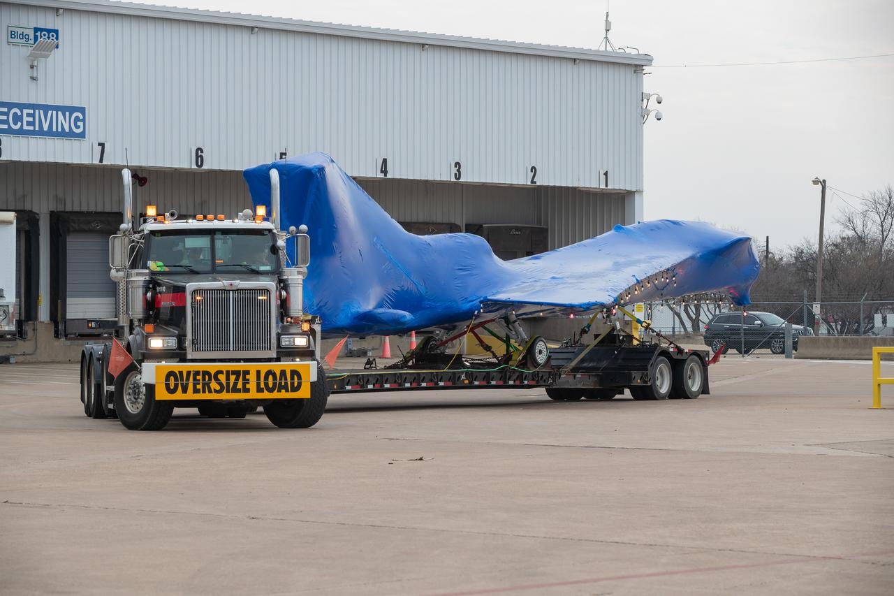
The X-59 arrives in Fort Worth, Texas from Palmdale, California, ready to undergo some important structural and fuel tests at the Lockheed Martin facility. The bright blue wrap around the X-plane is a precautionary measure to keep the exterior of the X-59 safe as it traveled through multiple states on its way to Texas.
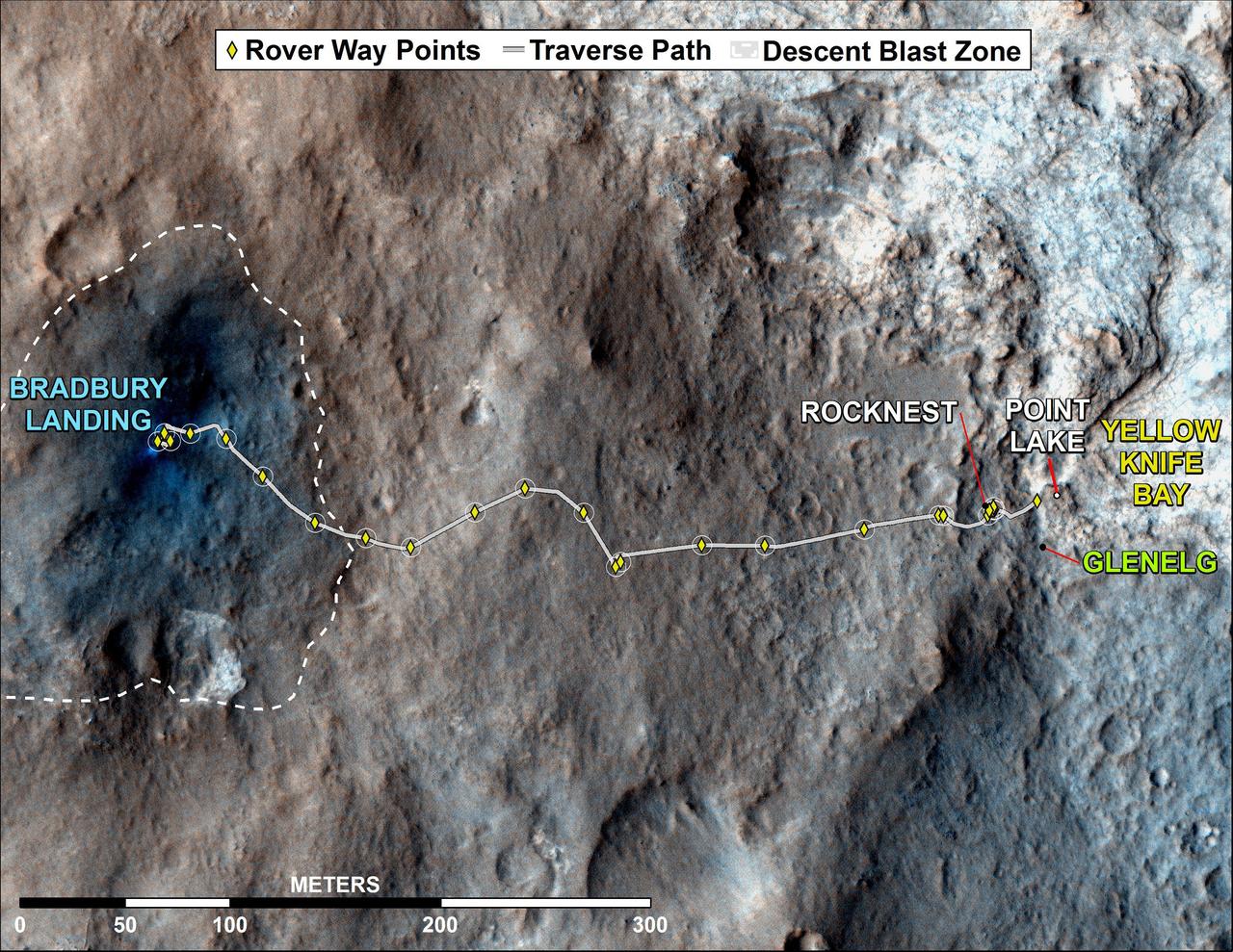
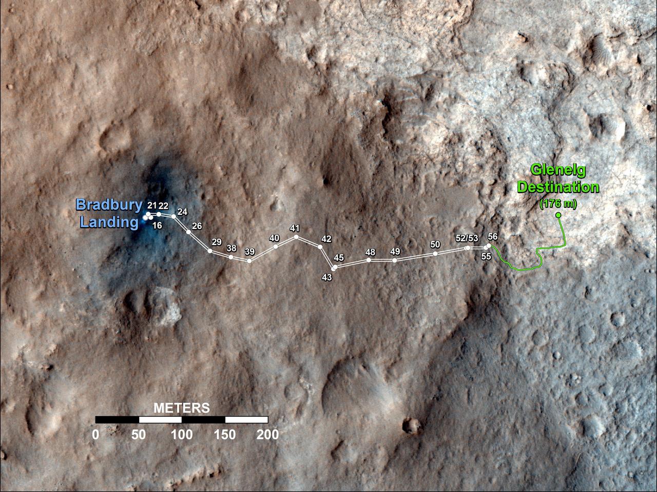
This map shows where NASA Mars rover Curiosity has driven since landing at a site subsequently named Bradbury Landing, and traveling to an overlook position near beside Point Lake, in drives totaling 1,703 feet 519 meters.
This 3-D view from behind NASA Mars Exploration Rover Opportunity shows the path the rover has traveled since rolling 1 meter 3 feet away from its empty lander on the seventh martian day, or sol, of its mission. 3D glasses are necessary.
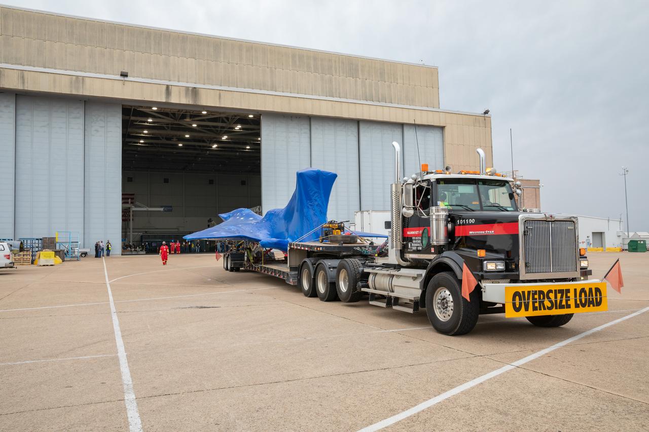
The X-59 arrives in Fort Worth, Texas from Palmdale, California, ready to undergo some important structural and fuel tests at the Lockheed Martin facility. The bright blue wrap around the X-plane is a precautionary measure to keep the exterior of the X-59 safe as it traveled through multiple states on its way to Texas.
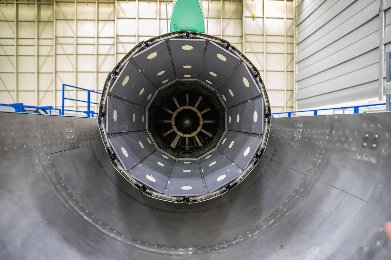
A look at the X-59’s engine nozzle, where the thrust -the force that moves the aircraft- will exit. Once complete, the X-59 is designed to fly supersonic while reducing the loud sonic boom. The Quesst mission could help change the rules for commercial supersonic air travel over land.

This artist conception based on data from NASA Wide-field Infrared Survey Explorer illustrates what brown dwarfs of different types might look like to a hypothetical interstellar traveler who has flown a spaceship to each one.
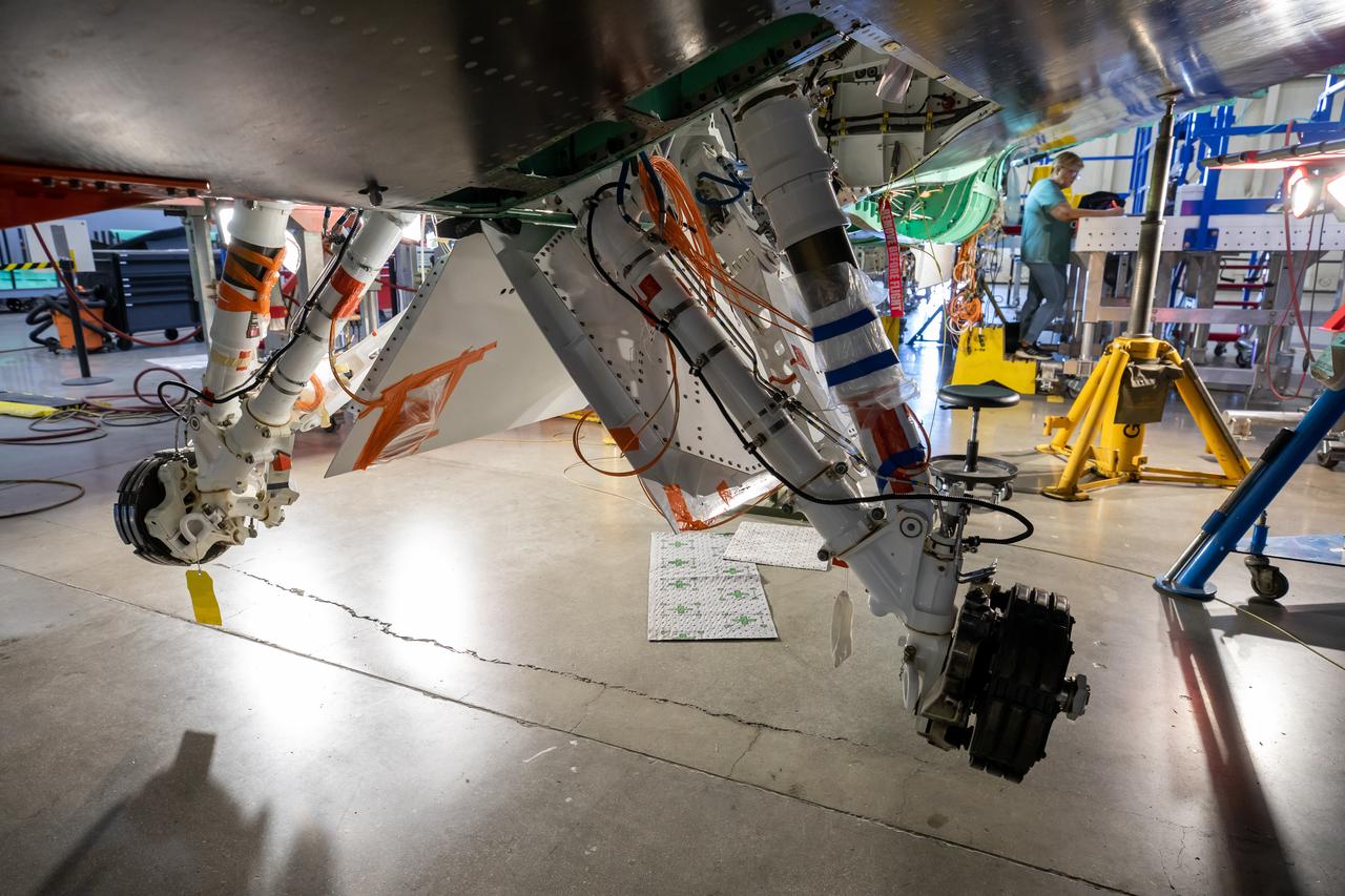
The Quesst team has repurposed the landing gear from an F-16 Fighting Falcon aircraft and is working on adjusting the fit onto the X-59 airplane. This is part of NASA’s Quesst mission which plans to help enable commercial supersonic air travel over land.
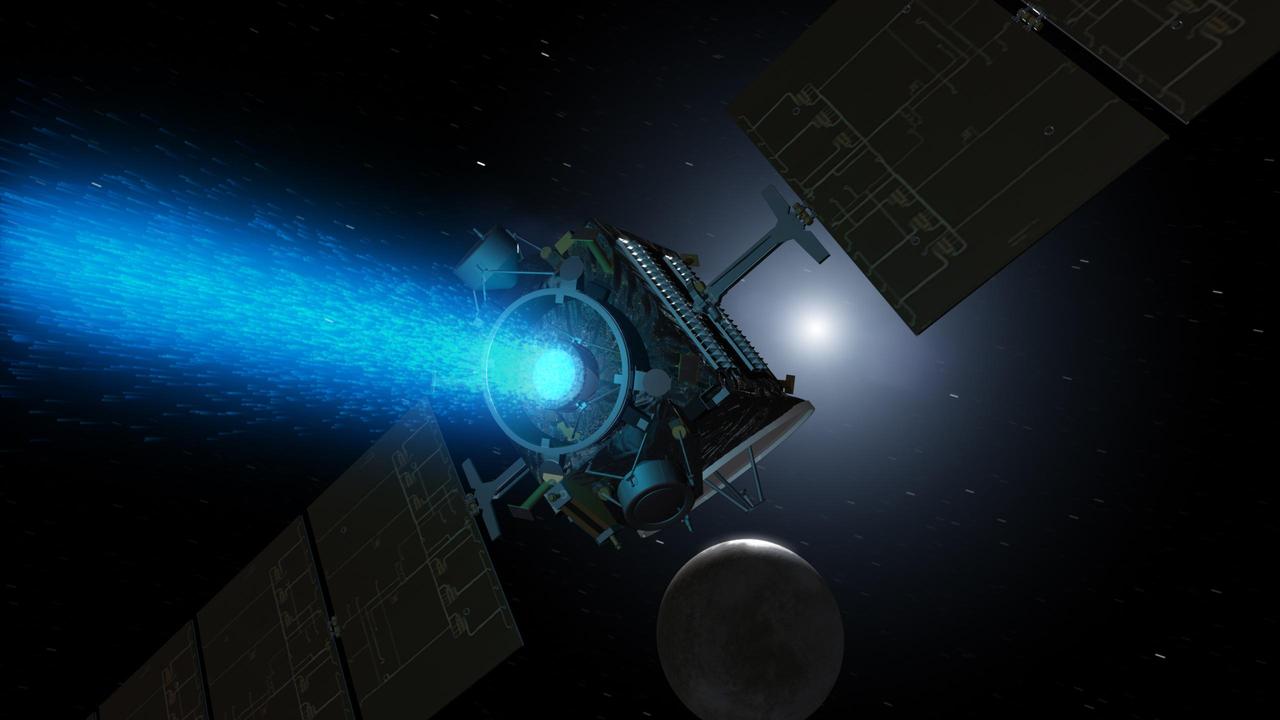
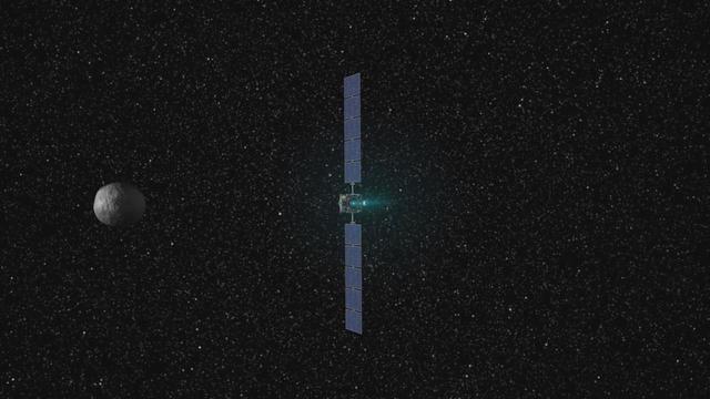
This artist concept shows NASA Dawn spacecraft arriving at the dwarf planet Ceres. Dawn travels through space using a technology called ion propulsion, with ions glowing with blue light are accelerated out of an engine, giving the spacecraft thrust.
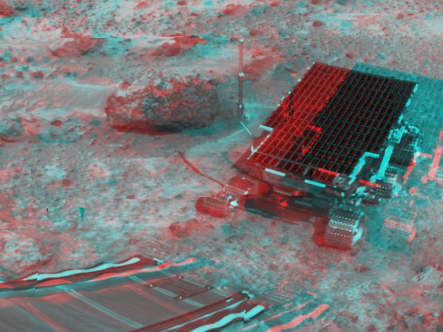
KENNEDY SPACE CENTER, FLA. - Workers walk with the suspended backshell/ Mars Exploration Rover 1 (MER-1) as it travels across the floor of the Payload Hazardous Servicing Facility. The backshell will be attached to the lower heat shield. NASA's twin Mars Exploration Rovers are designed to study the history of water on Mars. These robotic geologists are equipped with a robotic arm, a drilling tool, three spectrometers, and four pairs of cameras that allow them to have a human-like, 3D view of the terrain. Each rover could travel as far as 100 meters in one day to act as Mars scientists' eyes and hands, exploring an environment where humans can't yet go. MER-1 is scheduled to launch June 25 as MER-B aboard a Delta II rocket from Cape Canaveral Air Force Station.
Dune fields in the high southern latitudes of Mars tell a mostly similar story during local summer. The dark dunes grow warmer than the surrounding bright plains because they absorb more sunlight. Dust devils form over the warm dunes but then dance out over the plains, spinning and performing pirouettes and leaving conspicuous dark tracks as bright dust is lifted from the surface. Loops in the tracks can often be used to discern the direction traveled by the dust devils, where in some cases, one track clearly overprints the other. https://photojournal.jpl.nasa.gov/catalog/PIA24148
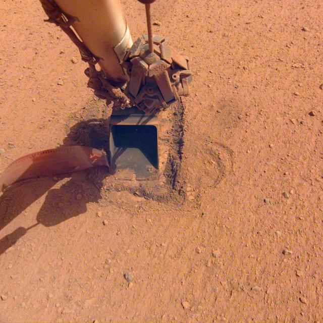
The "mole," a heat probe that traveled to Mars aboard NASA's InSight lander, as it looked after hammering on Saturday, Jan. 9, 2021, the 754th Martian day, or sol, of the mission. Since Feb. 28, 2019, the probe has been attempting to burrow into the Martian surface to take the planet's internal temperature. But the sand's unexpected tendency to clump deprived the spike-like mole of the friction it needs to hammer itself to a sufficient depth. On Jan. 9, with no progress, the team called an end to their efforts. Movie available at https://photojournal.jpl.nasa.gov/catalog/PIA24263
The faint dark lines in this image captured by NASA 2001 Mars Odyssey spacecraft are caused by dust devils. As the dust devil travels along the surface it scours away the loose surface dust, revealing the darker surface beneath. Orbit Number: 58268 Latitude: -51.7254 Longitude: 17.0688 Instrument: VIS Captured: 2015-02-01 12:25 http://photojournal.jpl.nasa.gov/catalog/PIA19271
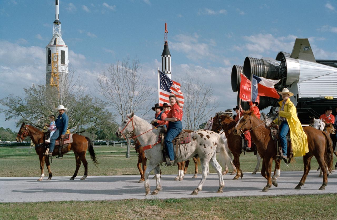
Rose Gardner of the JSC Travel Office, center, rides with the Independence Trail Riders as they enter JSC at Rocket Park.
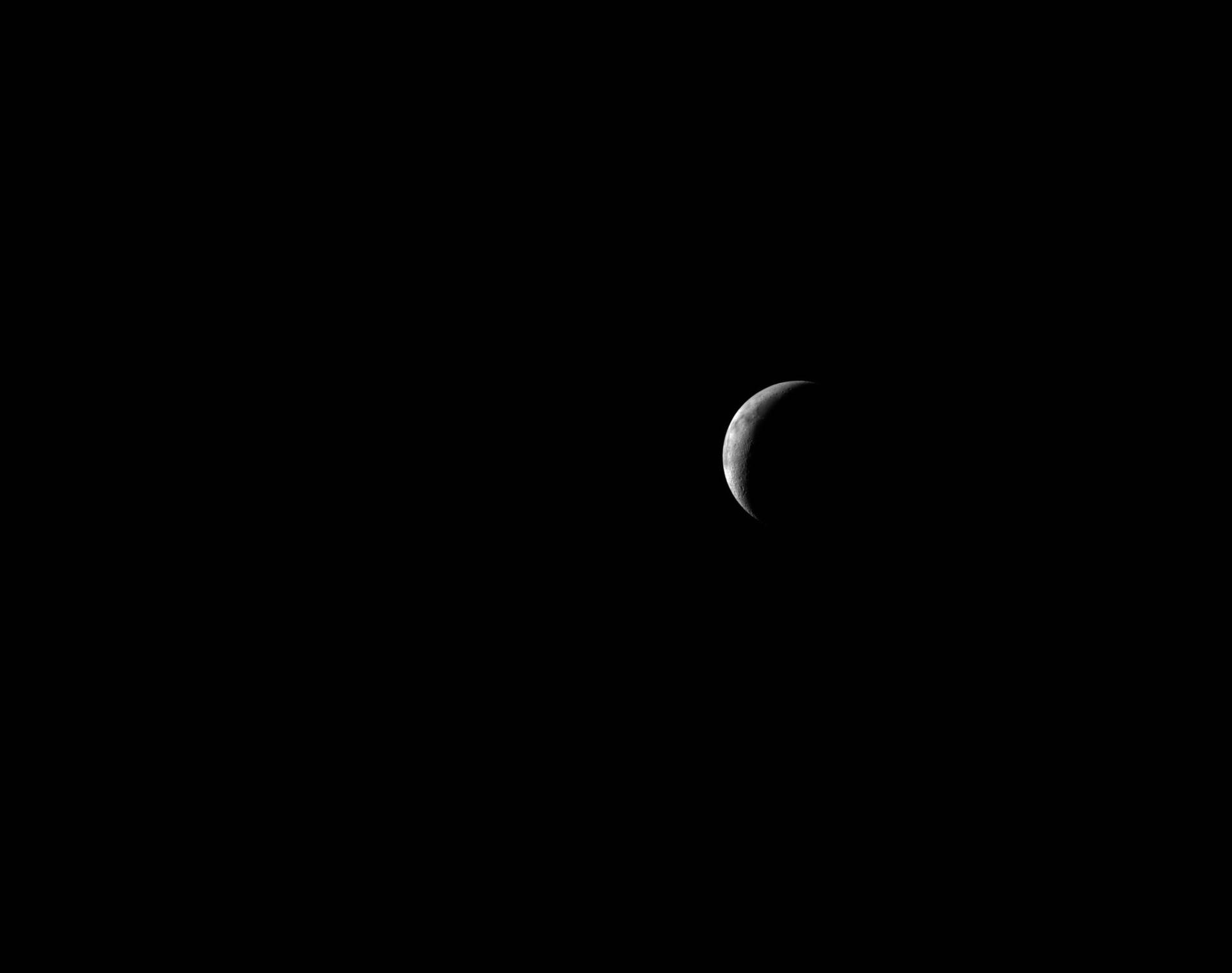
art002e016354 (April 8, 2026) The Artemis II crew captures a thin lunar crescent as they travel back to Earth.

This animation shows the events that serve as the basis of an astrophysics technique called "echo mapping," also known as reverberation mapping. At center is a supermassive black hole surrounded by a disk of material called an accretion disk. As the disk gets brighter it sometimes even releases short flares of visible light. Blue arrows show the light from this flash traveling away from the black hole, both toward an observer on Earth and toward an enormous, doughnut-shaped structure (called a torus) made of dust. The light gets absorbed, causing the dust to heat up and release infrared light. This brightening of the dust is a direct response to — or, one might, say an "echo" — of the changes happening in the disk. Red arrows show this light traveling away from the galaxy, in the same direction as the initial flash of visible light. Thus an observer would see the visible light first, and (with the right equipment) the infrared light later. Astronomers have previously proposed using echo mapping as a means of measuring distances to cosmic objects. If scientists can observe both the initial flare of visible light and the subsequent infrared brightening in the dust, they could in theory use that information to measure the disk's luminosity, which could then be used to measure the distance to that galaxy by comparing it to the galaxy's brightness as seen from Earth. The temperature in the part of the disk closest to the black hole can reach tens of thousands of degrees but decreases with distance. When it reaches about 2,200 degrees Fahrenheit (1,200 Celsius), it is cool enough for dust to form. The more luminous the disk, the farther away from it the dust forms and the longer it takes light from the disk to reach the dust and produce the "echo." The distance from the accretion disk to the inside of the dust doughnut can be billions or trillions of miles. Even light, traveling at 186,000 miles (300,000 kilometers) per second, can take months or years to cross it. NASA's Near Earth Object Wide Field Infrared Survey Explorer (NEOWISE), previously named WISE, surveys the entire sky about once every six months and is on track to complete 16 such surveys by the end of 2020, providing astronomers with repeated opportunities to observe galaxies and look for signs of those light echoes. A study using data from WISE measured the luminosity of over 500 black hole accretion disks using echo mapping, but the subsequent distance measurements lacked precision compared to other distance measuring techniques. Additional data and an improved understanding of dust torus dynamics could improve those measurements. Movie available at https://photojournal.jpl.nasa.gov/catalog/PIA23866
![jsc2022e057892 (5/12/2022) --- The SpaceOMIX team traveling to Space Applications Services, Brussels, Belgium for sample integration [Credit: Space Applications Services, NV/SA]](https://images-assets.nasa.gov/image/jsc2022e057892/jsc2022e057892~medium.jpg)
jsc2022e057892 (5/12/2022) --- The SpaceOMIX team traveling to Space Applications Services, Brussels, Belgium for sample integration [Credit: Space Applications Services, NV/SA]
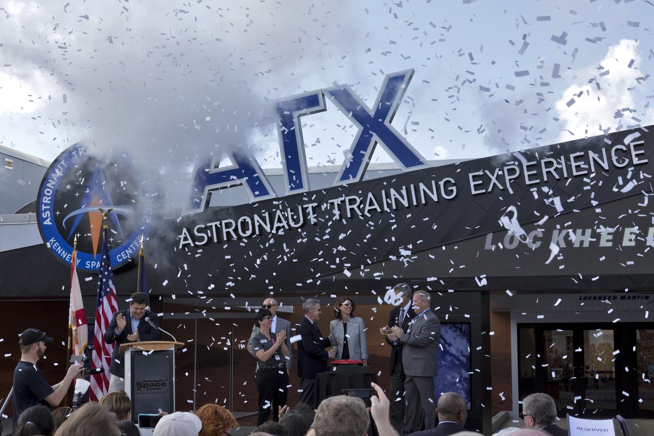
Confetti flies during the opening ceremony for the new Astronaut Training Experience (ATX) at the Kennedy Space Center Visitor Complex. The ATX uses three-dimensional computer display simulation technology to "transport" participants to Mars, training them to live and work in the environment of the Red Planet. The educational experience also teaches what it’s like to travel there. The facility uses NASA science to address engineering challenges in space travel. Lockheed Martin is the title sponsor for the Astronaut Training Experience.
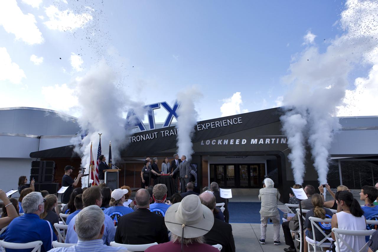
Guests cheer the opening of the new Astronaut Training Experience (ATX) at the Kennedy Space Center Visitor Complex. The ATX uses three-dimensional computer display simulation technology to "transport" participants to Mars, training them to live and work in the environment of the Red Planet. The educational experience also teaches what it’s like to travel there. The facility uses NASA science to address engineering challenges in space travel. Lockheed Martin is the title sponsor for the Astronaut Training Experience.

iss042e021398 (12/5/2014) --- A view of Microbiome swab kit containing Microbiome samples from various physical surfaces prior to being stowed in MELFI or GLACIER. The Study of the Impact of Long-Term Space Travel on the Astronauts' Microbiome (Microbiome) experiment investigates the impact of space travel on both the human immune system and an individual’s microbiome (the collection of microbes that live in and on the human body at any given time).

A model of the first Low Boom Flight Demonstrator is seen at a briefing on Tuesday, April 3, 2018 at NASA Headquarters in Washington. This new experimental aircraft will cut cross country travel times in half by flying faster than the speed of sound without creating a sonic boom, enabling travel from New York to Los Angeles in two hours. Photo Credit: (NASA/Aubrey Gemignani)