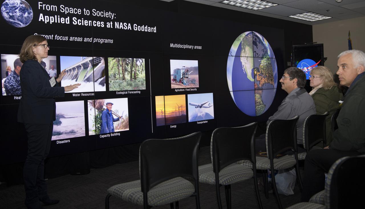
Mr. Lai Chien-Hsin Director General of Taiwan's Water Resources Agency and staff of US Bureau of Reclamation visited Goddard November 15, 2018 They toured facilties such as Hyperwall - Stephanie Uz
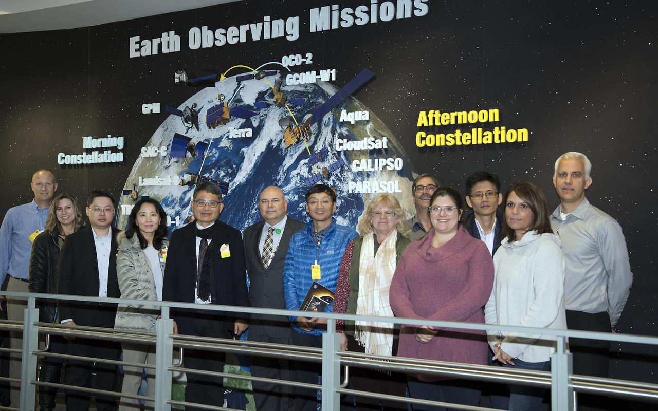
Mr. Lai Chien-Hsin, Director Genreal of Taiwan’s Water Resources Agency and staff US Bureau of Reclamation visited Goddard November 15, 2018 They toured Hyperwall and Earth Sciences facilities
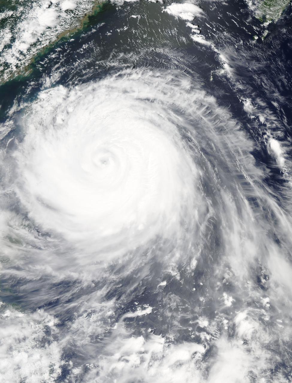
The MODIS instrument aboard NASA's Aqua satellite flew over Typhoon Soudelor on Aug. 7, 2015, at 4:40 UTC (12:40 a.m. EDT) as it was approaching Taiwan. Credits: NASA Goddard's MODIS Rapid Response Team Clouds in Typhoon Soudelor's western quadrant were already spreading over Taiwan early on August 7 when NASA's Aqua satellite passed overhead. Soudelor is expected to make landfall and cross central Taiwan today and make a second landfall in eastern China. NASA satellite imagery revealed that Soudelor's eye "opened" five more miles since August 4. On Aug. 7 at 4:40 UTC (12:40 a.m. EDT) the Moderate Resolution Imaging Spectroradiometer or MODIS instrument aboard NASA's Aqua satellite captured a visible-light image of Typhoon Soudelor as its western quadrant began brushing eastern Taiwan. The MODIS image showed Soudelor's 17-nautical-mile-wide eye and thick bands of powerful thunderstorms surrounded the storm and spiraled into the center. Just three days before, the eye was 5 nautical miles smaller when the storm was more intense. On Aug. 4 at 4:10 UTC (12:10 a.m. EDT) Aqua's MODIS image showed the eye was 12-nautical-mile-wide eye. At 1500 UTC (11 a.m. EDT) on August 7, 2015, the Joint Typhoon Warning Center (JTWC) noted that Typhoon Soudelor's maximum sustained winds increased from 90 knots (103.6 mph/166.7 kph) to 105 knots (120.8 mph / 194.5 kph). It was centered near 23.1 North latitude and 123.2 East longitude, about 183 nautical miles (210.6 miles/338.9 km) southeast of Taipei, Taiwan. It was moving to the west-northwest at 10 knots (11.5 mph/18.5 kph). For warnings and watches for Taiwan, visit the Central Weather Bureau website: <a href="http://www.cwb.gov.tw/eng/" rel="nofollow">www.cwb.gov.tw/eng/</a>. For warnings in China, visit the China Meteorological Administration website: <a href="http://www.cma.gov.cn/en" rel="nofollow">www.cma.gov.cn/en</a>. Soudelor's final landfall is expected in eastern China on Saturday, August 8. Clouds in Typhoon Soudelor's western quadrant were already spreading over Taiwan early on August 7 when NASA's Aqua satellite passed overhead. Soudelor is expected to make landfall and cross central Taiwan today and make a second landfall in eastern China. NASA satellite imagery revealed that Soudelor's eye "opened" five more miles since August 4. On Aug. 7 at 4:40 UTC (12:40 a.m. EDT) the Moderate Resolution Imaging Spectroradiometer or MODIS instrument aboard NASA's Aqua satellite captured a visible-light image of Typhoon Soudelor as its western quadrant began brushing eastern Taiwan. The MODIS image showed Soudelor's 17-nautical-mile-wide eye and thick bands of powerful thunderstorms surrounded the storm and spiraled into the center. Just three days before, the eye was 5 nautical miles smaller when the storm was more intense. On Aug. 4 at 4:10 UTC (12:10 a.m. EDT) Aqua's MODIS image showed the eye was 12-nautical-mile-wide eye. At 1500 UTC (11 a.m. EDT) on August 7, 2015, the Joint Typhoon Warning Center (JTWC) noted that Typhoon Soudelor's maximum sustained winds increased from 90 knots (103.6 mph/166.7 kph) to 105 knots (120.8 mph / 194.5 kph). It was centered near 23.1 North latitude and 123.2 East longitude, about 183 nautical miles (210.6 miles/338.9 km) southeast of Taipei, Taiwan. It was moving to the west-northwest at 10 knots (11.5 mph/18.5 kph). For warnings and watches for Taiwan, visit the Central Weather Bureau website: <a href="http://www.cwb.gov.tw/eng/" rel="nofollow">www.cwb.gov.tw/eng/</a>. For warnings in China, visit the China Meteorological Administration website: <a href="http://www.cma.gov.cn/en" rel="nofollow">www.cma.gov.cn/en</a>. Soudelor's final landfall is expected in eastern China on Saturday, August 8.
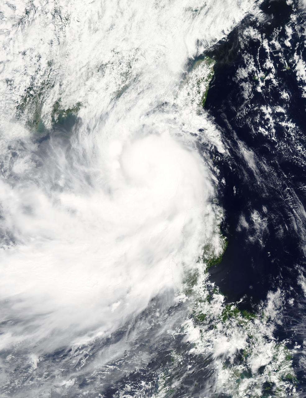
NASA's Aqua satellite captured a picture of Tropical Storm Linfa in the South China Sea on July 7 when it was between southern Taiwan and the northern Philippines. Aqua passed over Linfa on July 7 at 05:25 UTC (1:25 a.m. EDT) and the Moderate Resolution Imaging Spectroradiometer or MODIS instrument captured a visible image of the storm. Bands of thunderstorms wrapping into the center of circulation from the south, draped over western Luzon. The MODIS image showed the tight concentration of thunderstorms around Linfa's center were located over the South China Sea. Fragmented bands of thunderstorms north of the center were brushing over Southern Taiwan while clouds from another band of fragmented thunderstorms stretched northwest through the Taiwan Strait. On July 7 at 1500 UTC (11 a.m. EDT), Tropical Storm Linfa's maximum sustained winds had increased to 50 knots (57.5 mph/92.6 kph), up from 45 knots (51.7 mph/83.3 kph) six hours before. Linfa strengthened in the warm waters of the South China Sea now that its center has moved away from the northern Philippines and was no longer over land. Linfa was centered near 21.0 North latitude and 118.8 East longitude, about 277 nautical miles (319 miles/513.3 km) east-southeast of Hong Kong, China. Linfa has tracked northward at 3 knots (3.5 mph/5.5 kph). China's National Meteorological Centre has (CNMC) issued a yellow category warning of typhoon at 6:00 a.m. July 7, Beijing Time. CNMC noted that Linfa is the tenth typhoon this year and at that time it was centered about 430 km (267.2 miles) southeast of border between Fujian and Guangdong For updated warnings and watches from the China Meteorological Service, visit: <a href="http://www.cma.gov.cn/en/WeatherWarnings/" rel="nofollow">www.cma.gov.cn/en/WeatherWarnings/</a>. Linfa is moving north between Luzon and Taiwan. The Joint Typhoon Warning Center expects Linfa to strengthen to 60 knots (69 mph/111 kph) by mid-day on July 9, before weakening and then making landfall in mainland China. Credit: NASA/GSFC/Jeff Schmaltz/MODIS Land Rapid Response Team <b><a href="http://www.nasa.gov/audience/formedia/features/MP_Photo_Guidelines.html" rel="nofollow">NASA image use policy.</a></b> <b><a href="http://www.nasa.gov/centers/goddard/home/index.html" rel="nofollow">NASA Goddard Space Flight Center</a></b> enables NASA’s mission through four scientific endeavors: Earth Science, Heliophysics, Solar System Exploration, and Astrophysics. Goddard plays a leading role in NASA’s accomplishments by contributing compelling scientific knowledge to advance the Agency’s mission. <b>Follow us on <a href="http://twitter.com/NASAGoddardPix" rel="nofollow">Twitter</a></b> <b>Like us on <a href="http://www.facebook.com/pages/Greenbelt-MD/NASA-Goddard/395013845897?ref=tsd" rel="nofollow">Facebook</a></b> <b>Find us on <a href="http://instagrid.me/nasagoddard/?vm=grid" rel="nofollow">Instagram</a></b>