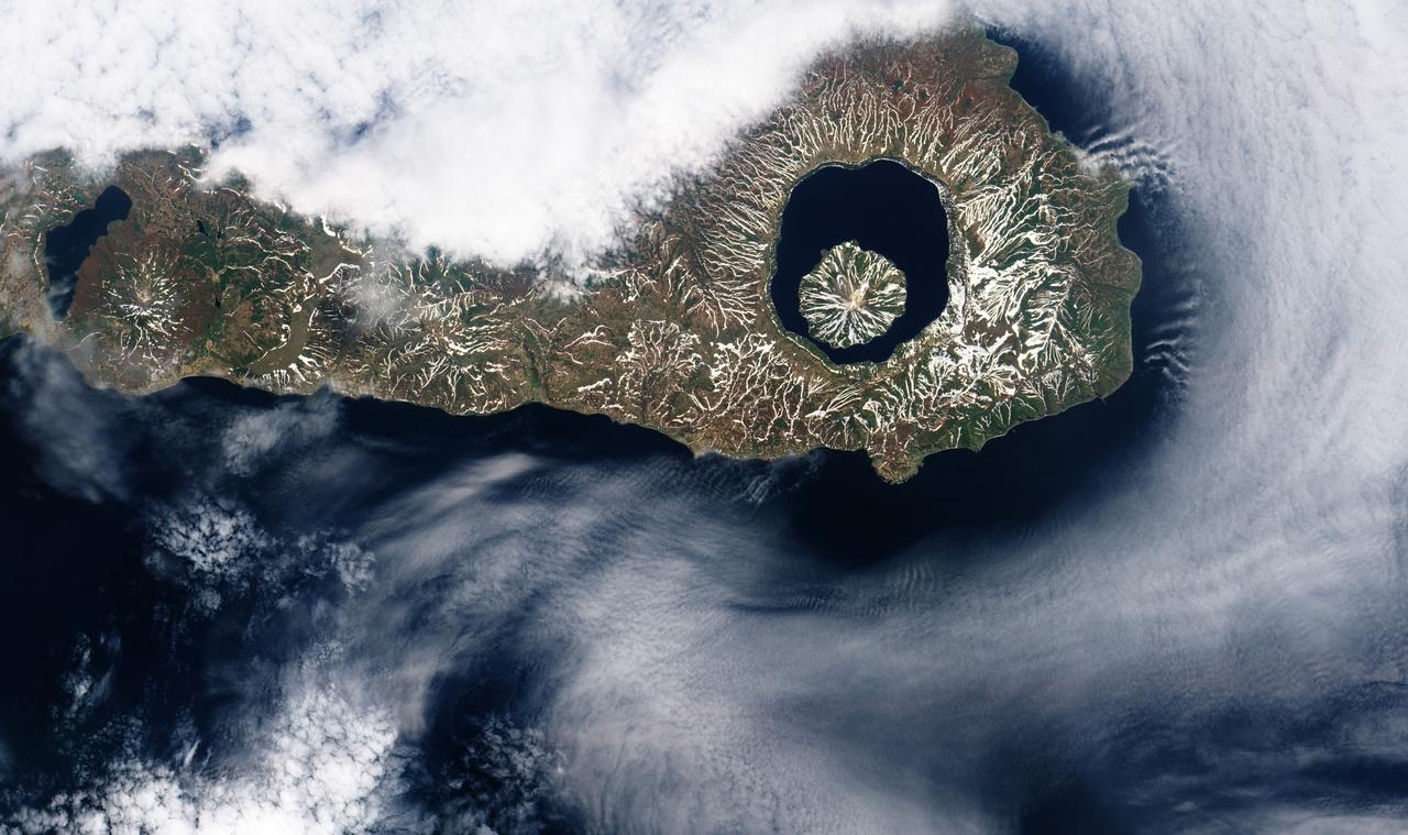
More than 9,000 years ago, a catastrophic volcanic eruption created a huge caldera on the southern end of Onekotan Island, one of the Kuril Islands, located off the southern tip of Russia’s Kamchatka Peninsula. Today, the ancient Tao-Rusyr Caldera is filled by the deep blue waters of Kal’tsevoe Lake. The Advanced Land Imager (ALI) on NASA’s Earth Observing-1 (EO-1) satellite acquired this true-color image of southern Onekotan on June 10, 2009. In this late-spring shot, snow or ice lingers on the land, forming white streaks on a brown-and-green land surface. In the northwest quadrant of the caldera is Krenitzyn Peak, which rises to a height of 1,325 meters (4,347 feet). Like the other Kuril Islands, Onekotan lies along the Pacific “Ring of Fire.” The Kuril Island volcanoes are fueled by magma generated by the subduction of the Pacific Plate under the Eurasian Plate, which takes place along a deep trench about 200 kilometers (120 miles) to the islands’ east. The only historical eruption at Krenitzyn Peak occurred in 1952, a week after a magnitude 9.0 earthquake along the subduction fault. NASA Earth Observatory image created by Robert Simmon, using EO-1 ALI data provided courtesy of the NASA EO-1 team. Caption by Michon Scott and Rebecca Lindsey. <b><a href="http://www.nasa.gov/audience/formedia/features/MP_Photo_Guidelines.html" rel="nofollow">NASA image use policy.</a></b> <b><a href="http://www.nasa.gov/centers/goddard/home/index.html" rel="nofollow">NASA Goddard Space Flight Center</a></b> enables NASA’s mission through four scientific endeavors: Earth Science, Heliophysics, Solar System Exploration, and Astrophysics. Goddard plays a leading role in NASA’s accomplishments by contributing compelling scientific knowledge to advance the Agency’s mission. <b>Follow us on <a href="http://twitter.com/NASAGoddardPix" rel="nofollow">Twitter</a></b> <b>Like us on <a href="http://www.facebook.com/pages/Greenbelt-MD/NASA-Goddard/395013845897?ref=tsd" rel="nofollow">Facebook</a></b> <b>Find us on <a href="http://instagrid.me/nasagoddard/?vm=grid" rel="nofollow">Instagram</a></b>
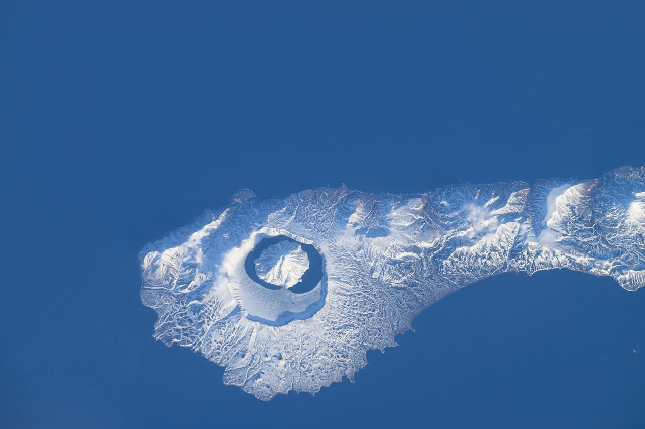
iss071e046424 (April 29, 2024) --- The snow-covered Onekotan Island, part of Russia's Kuril Islands, is home to the Tao-Rusyr Caldera stratovolcano in this photograph. Inside the caldera is the Krenitsyna Volcano peak surrounded by the partially ice-covered Kol'tsevoe Lake. The International Space Station was orbiting 259 miles above the Pacific Ocean at the time of this photograph.
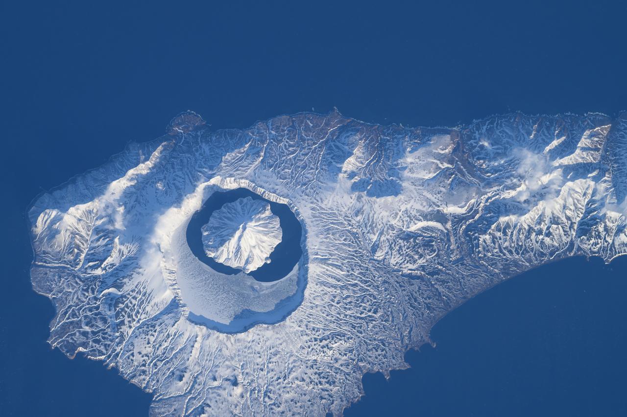
iss071e046421 (April 29, 2024) -- In the north end of the Kuril island chain is Onekotan, an uninhabited volcanic island, home to Krenitsyn volcano, pictured here from the International Space Station as it orbited 260 miles above. The volcano rises 900 meters (~3,000 feet) at its highest point and surrounding it is Tao-Rusyr Caldera.
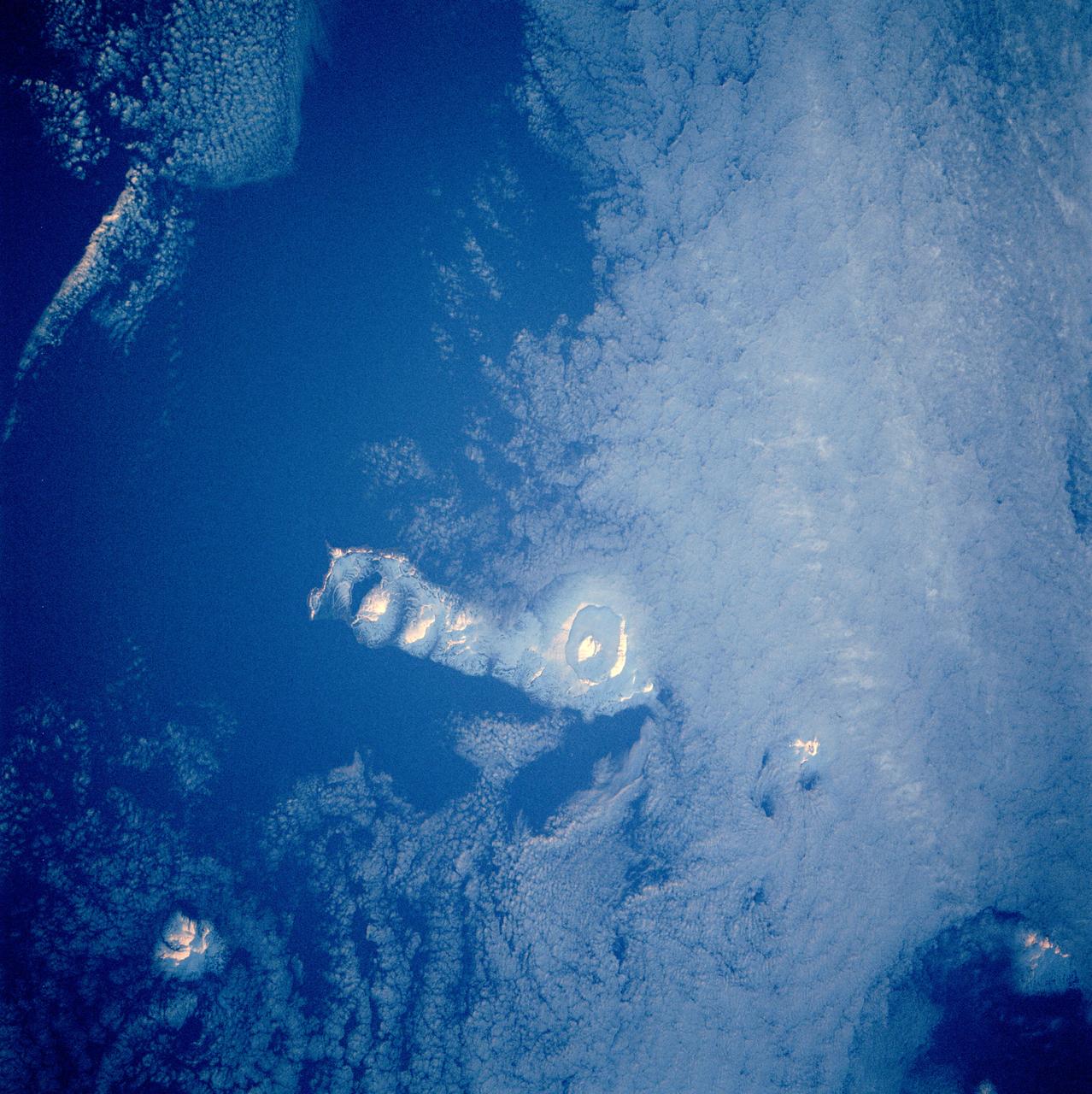
STS084-712-003 (15-24 May 1997) --- Early morning sun highlights the volcanic features on Onekotan Island which is one of several volcanic islands in the Russian owned Kurile Island chain. Onekotan lies just south of Kamchatka. Two volcanoes are active on the island -- the small island surrounded by a moat-like lake in the south (Tao-Rusyr caldera) last erupted in 1952, and the cone-shaped peak at the north end of the island, Nemo peak, erupted in 1938.
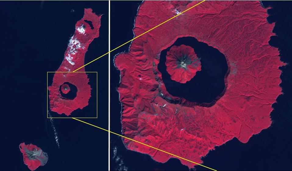
The Kuril Islands are a volcanic archipelago, stretching 1300 km from Hokkaido, Japan to Kamchatka, Russia. They are part of the Pacific Ring of Fire, the result of subduction of the Pacific Plate under the Okhotsk Plate along the Kuril Trench. At the southern end of Onekotan Island is the Tao-Rusyr Caldera stratovolcano, with its 7500 year old caldera lake. The most recent eruption was in 1952. The smaller Kharimkotan Island to the southwest last erupted in 1933. Collapse of this volcano created a horseshoe-shaped crater, and caused a tsunami that killed two people on a near-by island. The image was acquired June 4, 2012; the enlargement covers an area of 17 by 18.5 km, and is located at 49.3 degrees north, 154.7 degrees east. https://photojournal.jpl.nasa.gov/catalog/PIA24020
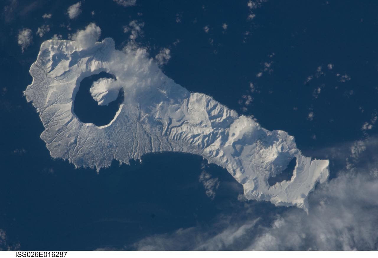
ISS026-E-016287 (9 Jan. 2011) --- Onekotan Island, part of the Russian Federation in the western Pacific Ocean, is featured in this image photographed by an Expedition 26 crew member on the International Space Station. Snow cover highlights calderas and volcanic cones that form the northern and southern ends of the island. Calderas are depressions formed when a volcano empties its magma chamber in an explosive eruption, followed by collapse of the overlaying material into the newly evacuated space. The northern end of the island is dominated by the Nemo Peak volcano that began forming within an older caldera approximately 9,500 years ago, according to scientists. The last recorded eruptive activity at Nemo Peak occurred in the early 18th century. The southern end of the island is formed by the 7.5 kilometer wide Tao-Rusyr Caldera. The caldera is filled by Kal’tsevoe Lake and Krenitzyn Peak, a volcano that has only erupted once in recorded history during 1952. Extending between northeastern Japan and the Kamchatka Peninsula of Russia, the Kuril Islands are an island arc located along the Pacific “Ring of Fire”. Island arcs form along an active boundary between two tectonic plates where one plate is being driven beneath the other (subduction). Magma generated by the subduction process feeds volcanoes—which eventually form volcanic islands—over the subduction boundary.