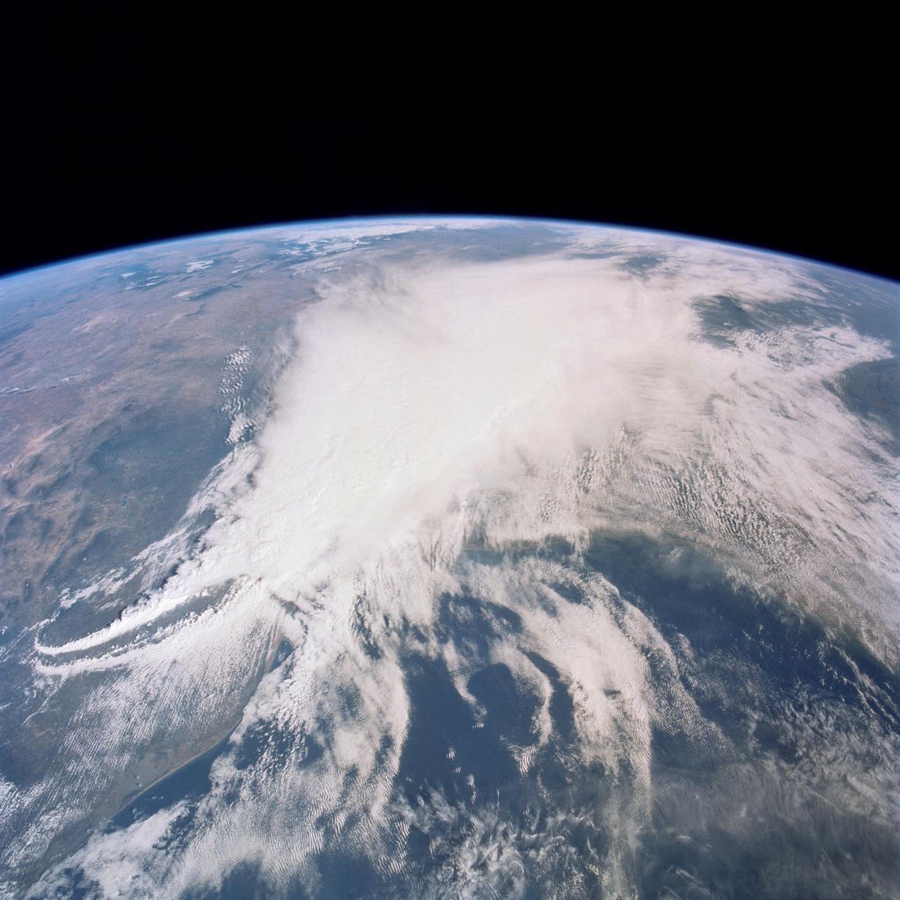
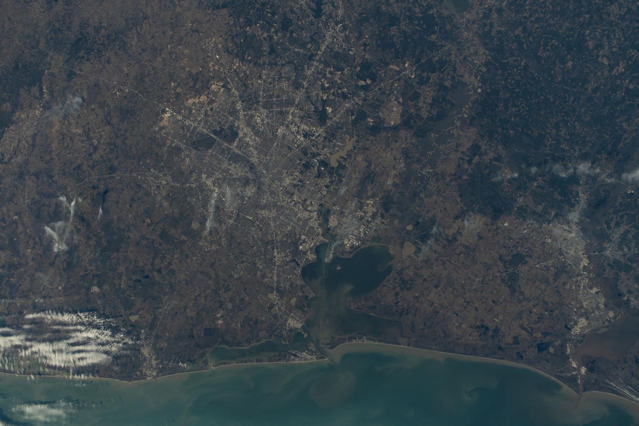
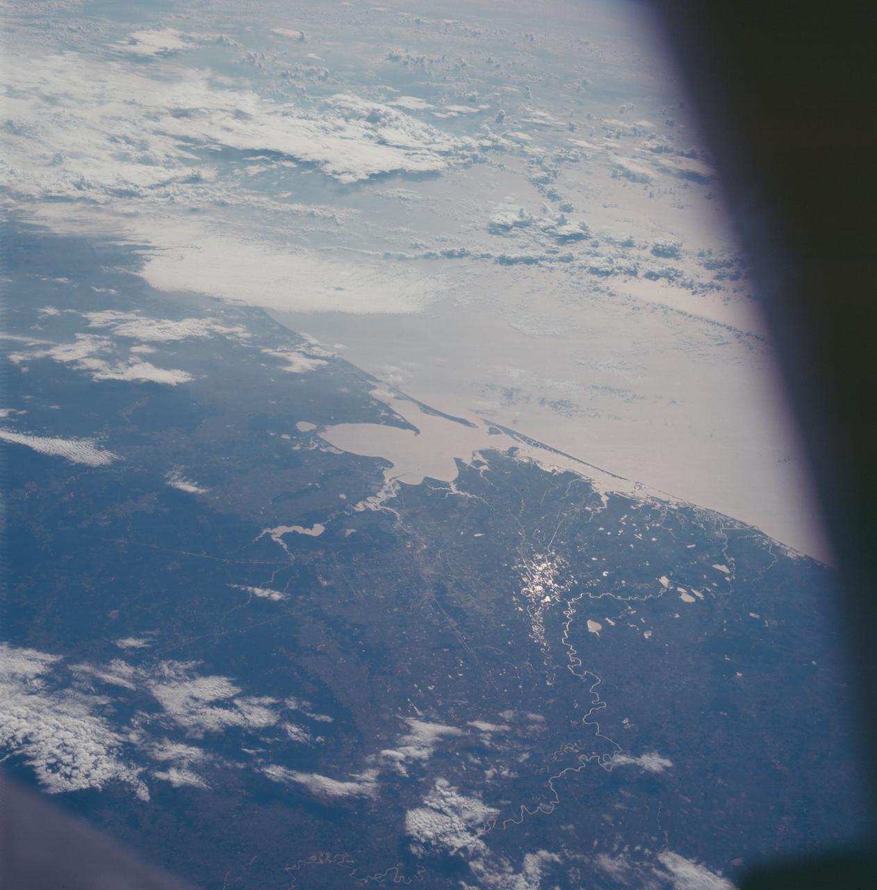
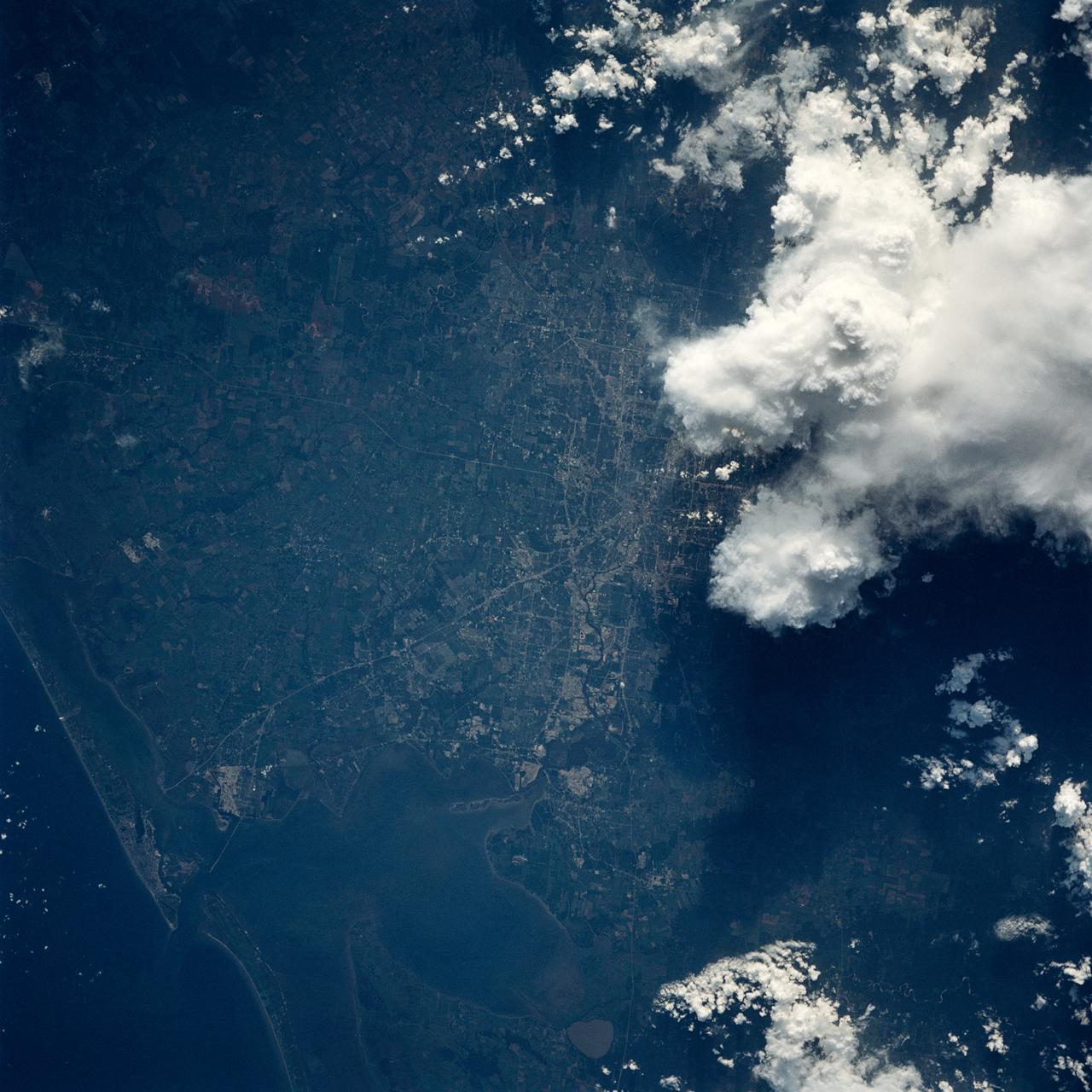
This thunderstorm along the Texas Gulf Coast (29.0N, 95.0W), USA is seen as the trailing edge of a large cloud mass formed along the leading edge of a spring frontal system stretching northwest to southeast across the Texas Gulf Coast. This system brought extensive severe weather and flooding to parts of Texas and surrounding states. Muddy water discharging from coastal streams can be seen in the shallow Gulf of Mexico as far south as Lavaca Bay.
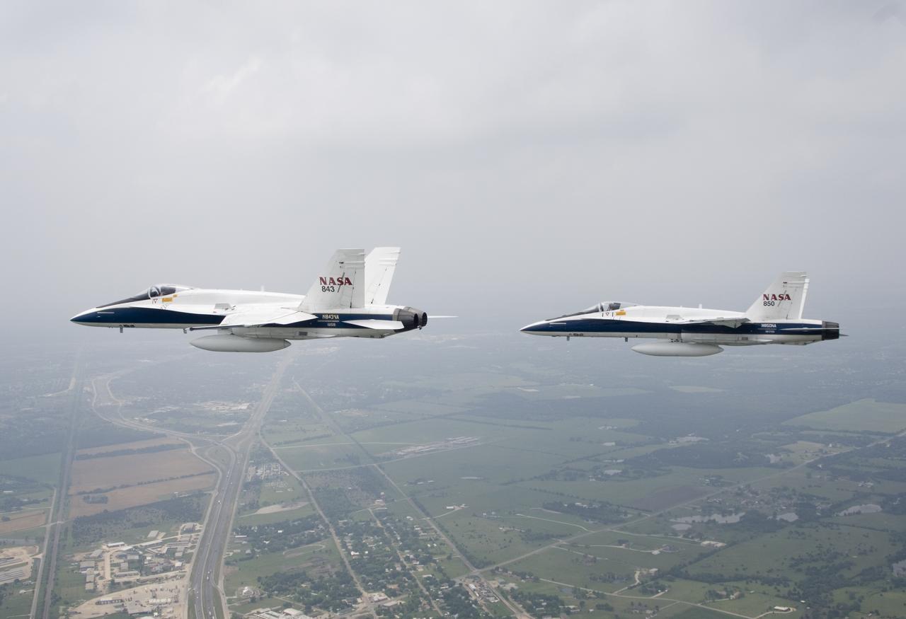
Two NASA F/A-18s flown by NASA Dryden research pilots Jim Smolka and Nils Larson cruise over the Texas landscape after supporting a SOFIA check flight in May 2007.
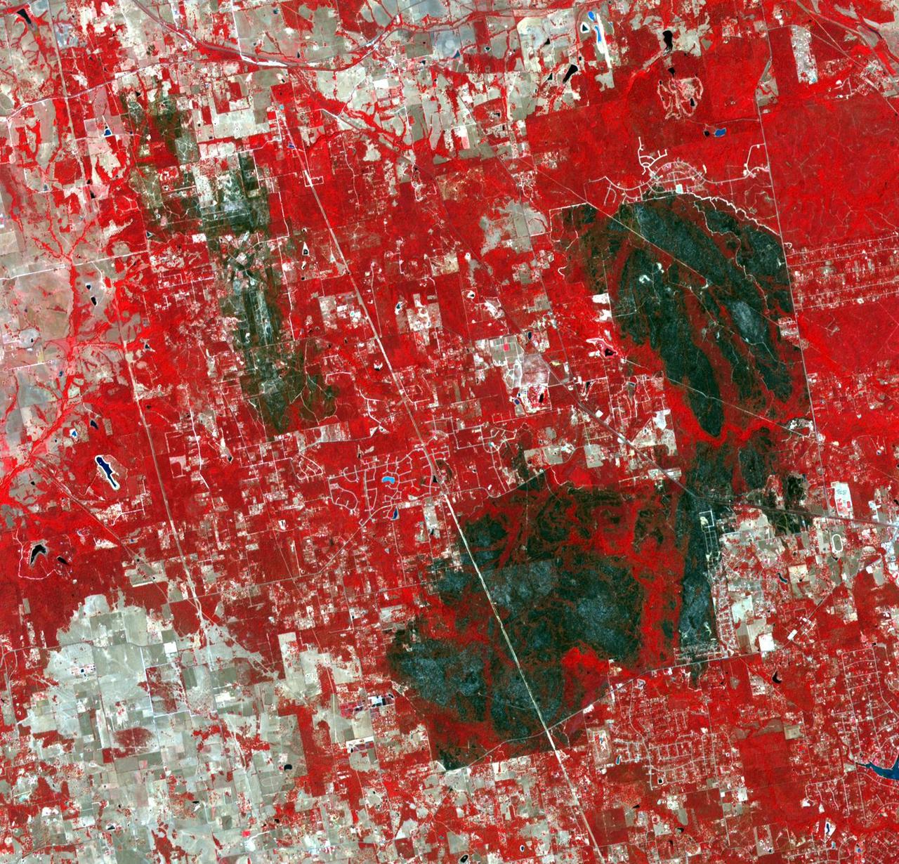
This image, acquired by NASA Terra spacecraft on May 1, 2011, shows more than 314,000 acres burned in west Texas. The 2011 fire season in Texas is of historic proportions.

AS6-02-1455 (4 April 1968) --- Texas is photographed from the Apollo 6 (Spacecraft 020/Saturn 502) unmanned space mission. Seen in this photograph are Midland, Brownfield, Big Spring, J. B. Thomas Lake, headwaters of Colorado and Brazos Rivers, and the west Texas gas and oil fields.
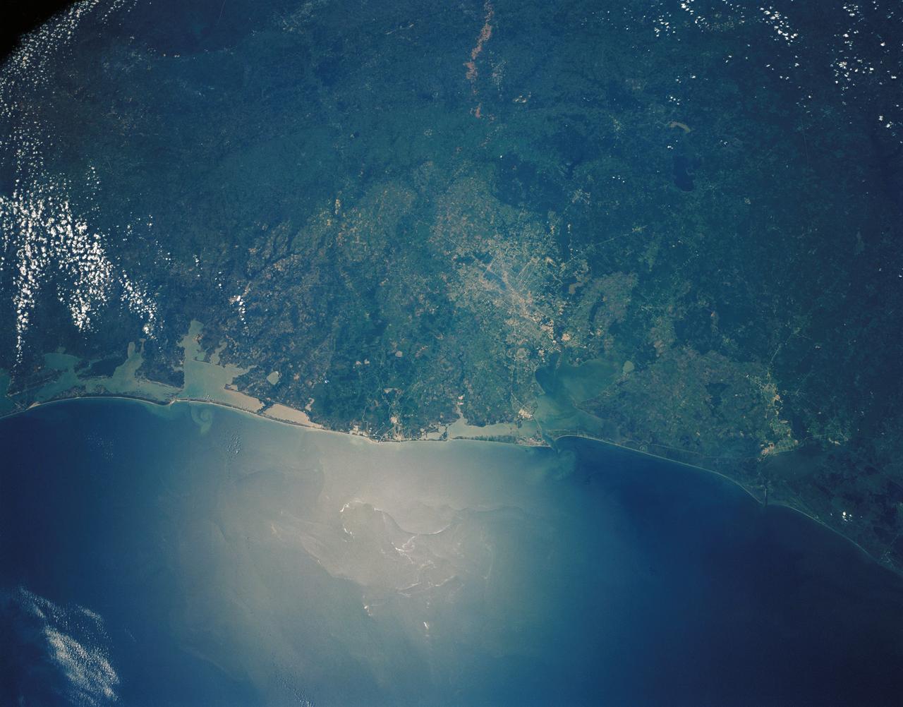
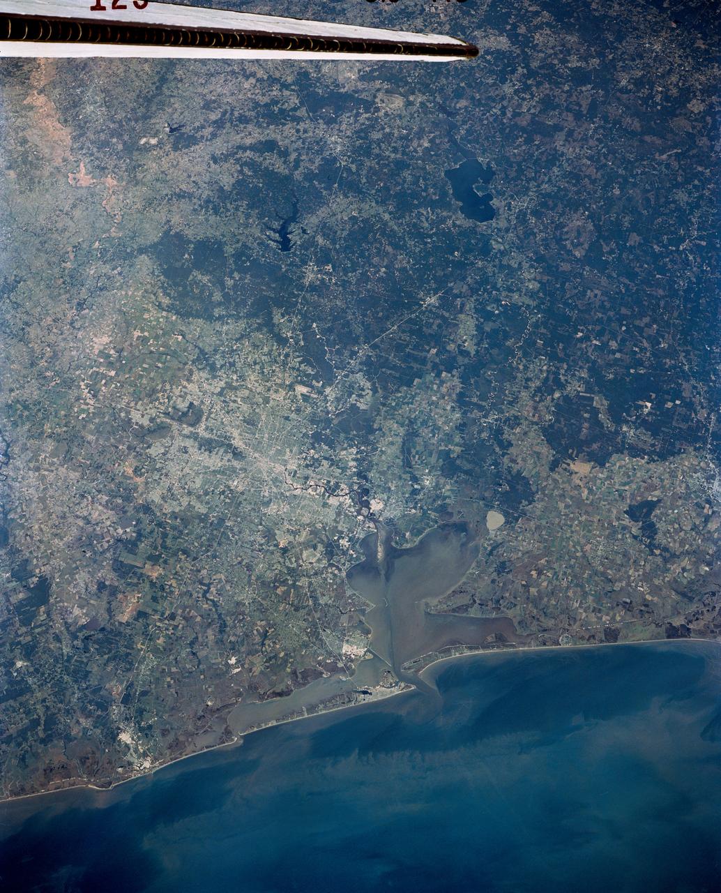
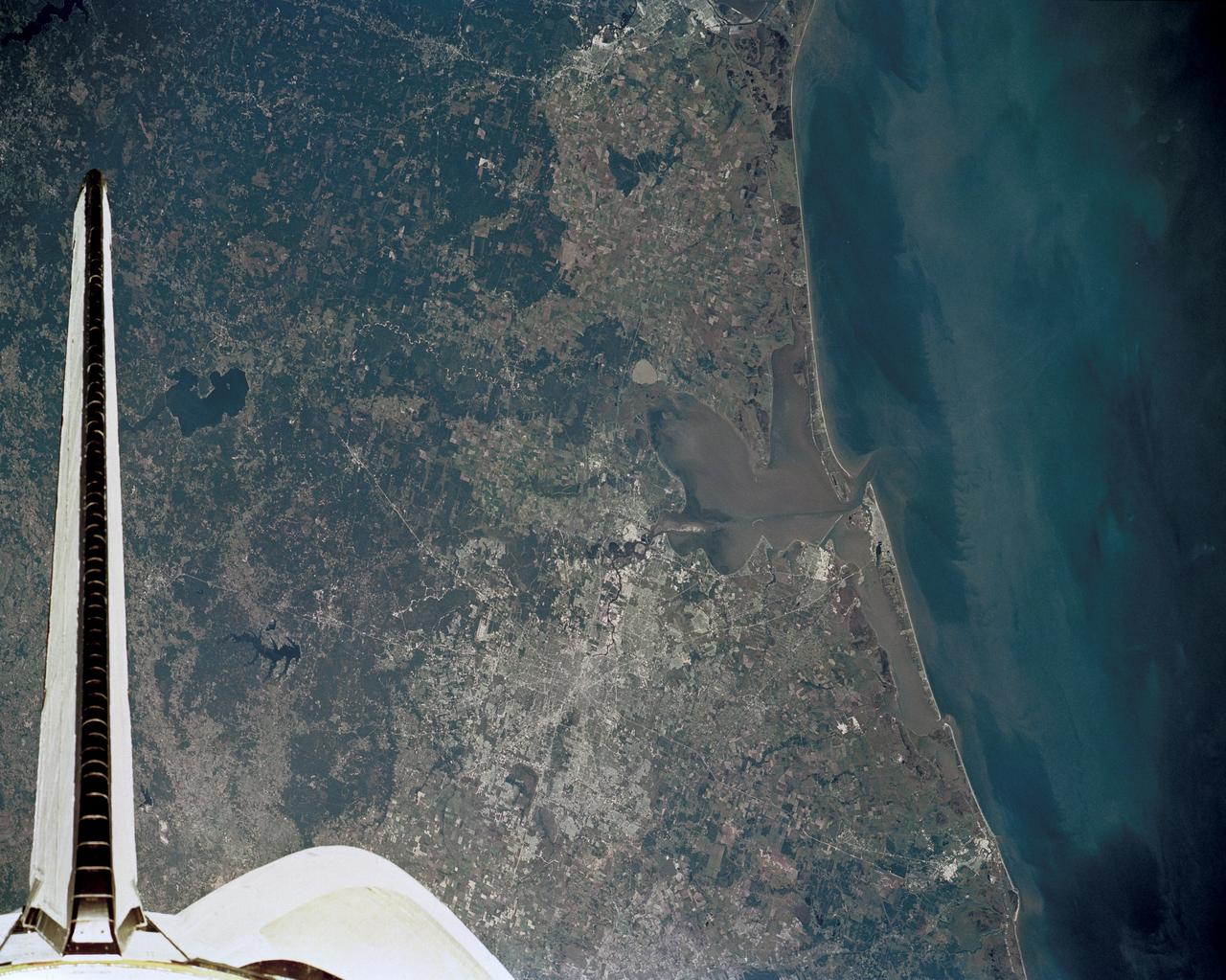
STS030-152-066 (4-8 May 1989) --- The upper Texas and Louisiana Gulf Coast area was clearly represented in this large format frame photographed by the astronaut crew of the Earth-orbiting Space Shuttle Atlantis. The area covered stretches almost 300 miles from Aransas Pass, Texas to Cameron, Louisiana. The sharp detail of both the natural and cultural features noted throughout the scene is especially evident in the Houston area, where highways, major streets, airport runways and even some neighborhood lanes are easily seen. Other major areas seen are Austin, San Antonio and the Golden Triangle. An Aero Linhof camera was used to expose the frame.
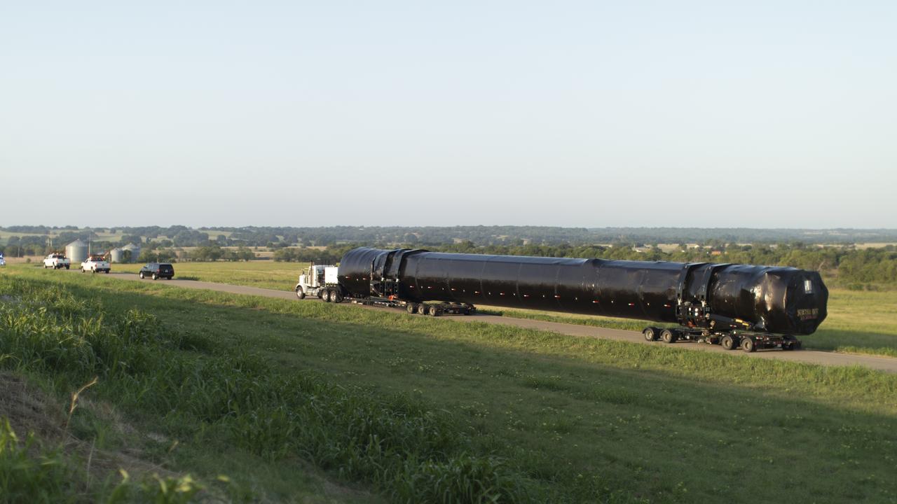
The SpaceX Falcon 9 first stage booster that will launch NASA’s SpaceX Crew-1 mission arrived in Florida Tuesday, July 14, 2020. The rocket was shipped from the SpaceX facility in McGregor, Texas, and will now undergo prelaunch processing in the company’s facility on nearby Cape Canaveral Air Force Station.

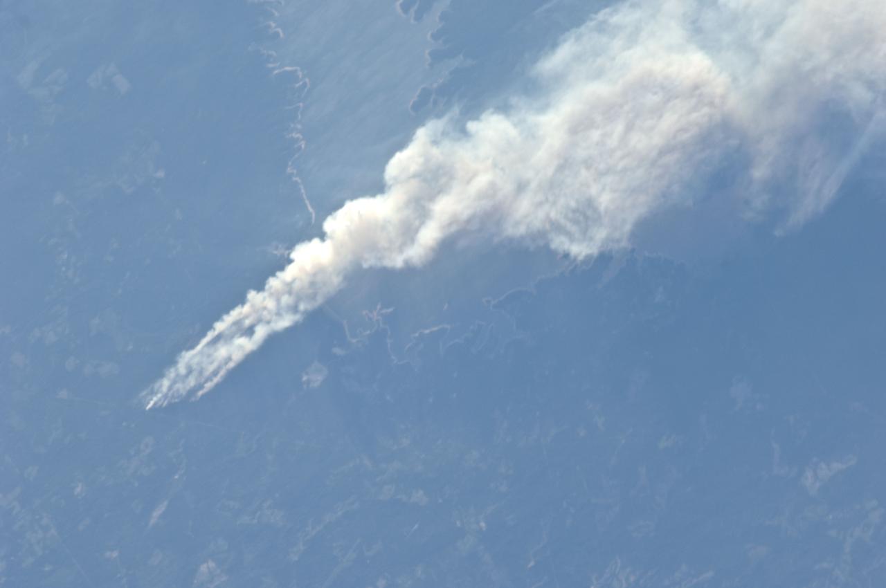
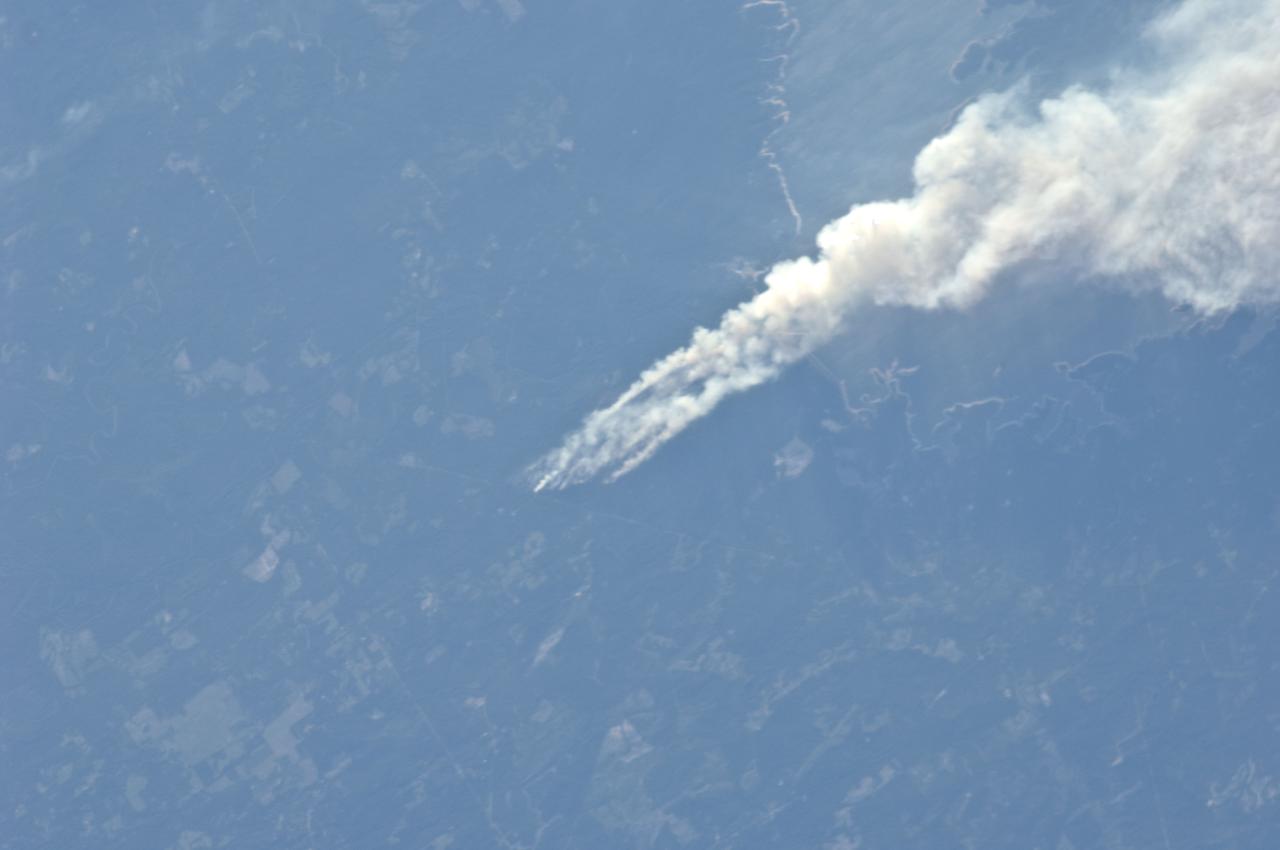
iss071e666237 (Sept. 17, 2024) --- NASA astronaut Don Pettit was able to capture a photo of a recent fire in La Porte, Texas yesterday. Our NASA Astronauts have the ability to observe natural disasters from a vantage point of 250 miles above Earth. The imagery and data provided from the International Space Station can provide benefits to regions that experience unexpected events such as fires, floods, hurricanes, earthquakes, and more. This information is valuable when monitoring disasters on Earth in real time.

NASA astronaut Don Pettit was able to capture a photo of a recent fire in La Porte, Texas yesterday. Our NASA Astronauts have the ability to observe natural disasters from a vantage point of 250 miles above Earth. The imagery and data provided from the International Space Station can provide benefits to regions that experience unexpected events such as fires, floods, hurricanes, earthquakes, and more. This information is valuable when monitoring disasters on Earth in real time.

iss071e666253 (Sept. 17, 2024) --- NASA astronaut Don Pettit was able to capture a photo of a recent fire in La Porte, Texas yesterday. Our NASA Astronauts have the ability to observe natural disasters from a vantage point of 250 miles above Earth. The imagery and data provided from the International Space Station can provide benefits to regions that experience unexpected events such as fires, floods, hurricanes, earthquakes, and more. This information is valuable when monitoring disasters on Earth in real time.
NASA satellite image showing the fires in Bastrop County Texas on September 5, 2011 at 17:05 UTC. Credit: NASA/GSFC/Jeff Schmaltz/MODIS Land Rapid Response Team <b><a href="http://www.nasa.gov/centers/goddard/home/index.html" rel="nofollow">NASA Goddard Space Flight Center</a></b> enables NASA’s mission through four scientific endeavors: Earth Science, Heliophysics, Solar System Exploration, and Astrophysics. Goddard plays a leading role in NASA’s accomplishments by contributing compelling scientific knowledge to advance the Agency’s mission. <b>Follow us on <a href="http://twitter.com/NASA_GoddardPix" rel="nofollow">Twitter</a></b> <b>Like us on <a href="http://www.facebook.com/pages/Greenbelt-MD/NASA-Goddard/395013845897?ref=tsd" rel="nofollow">Facebook</a></b> <b>Find us on <a href="http://instagrid.me/nasagoddard/?vm=grid" rel="nofollow">Instagram</a></b>
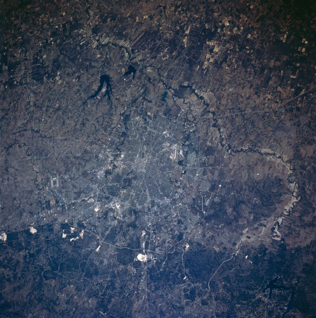
STS058-101-053 (18 Oct-1 Nov 1993) --- This sharp cloud-free photograph of San Antonio, Texas illustrates the classic pattern of western cities. The Hispanic heart of the city; an intertwining of streets along the San Antonio River and around the Alamo, surrounded by a late 19th century Anglo grid of small businesses and suburban homes. Transportation routes radiate to mid and late 20th Century ring corridors separating the urban/suburban region from the surrounding agricultural countryside. San Antonio was founded around permanent springs that rise at the foot of the Balcones Escarpment, which separates the Texas Hill Country from the South Texas Plains. Limestone quarries are conspicuous along the edge of the escarpment. San Antonio has long been a major site for military training bases: Randolph Air Force Base is outside the city to the northeast, Fort Sam Houston is contained within the northeast quadrant of the city, Brooks Air Force Base lies at the southeastern corner, and Lackland and Kelly Air Force Bases are within the suburban fringe to the southwest. San Antonio International Airport can be seen at the foot of the escarpment in the northern part of the city.
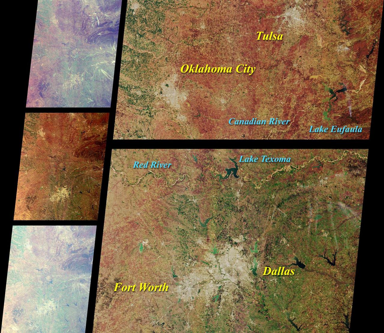
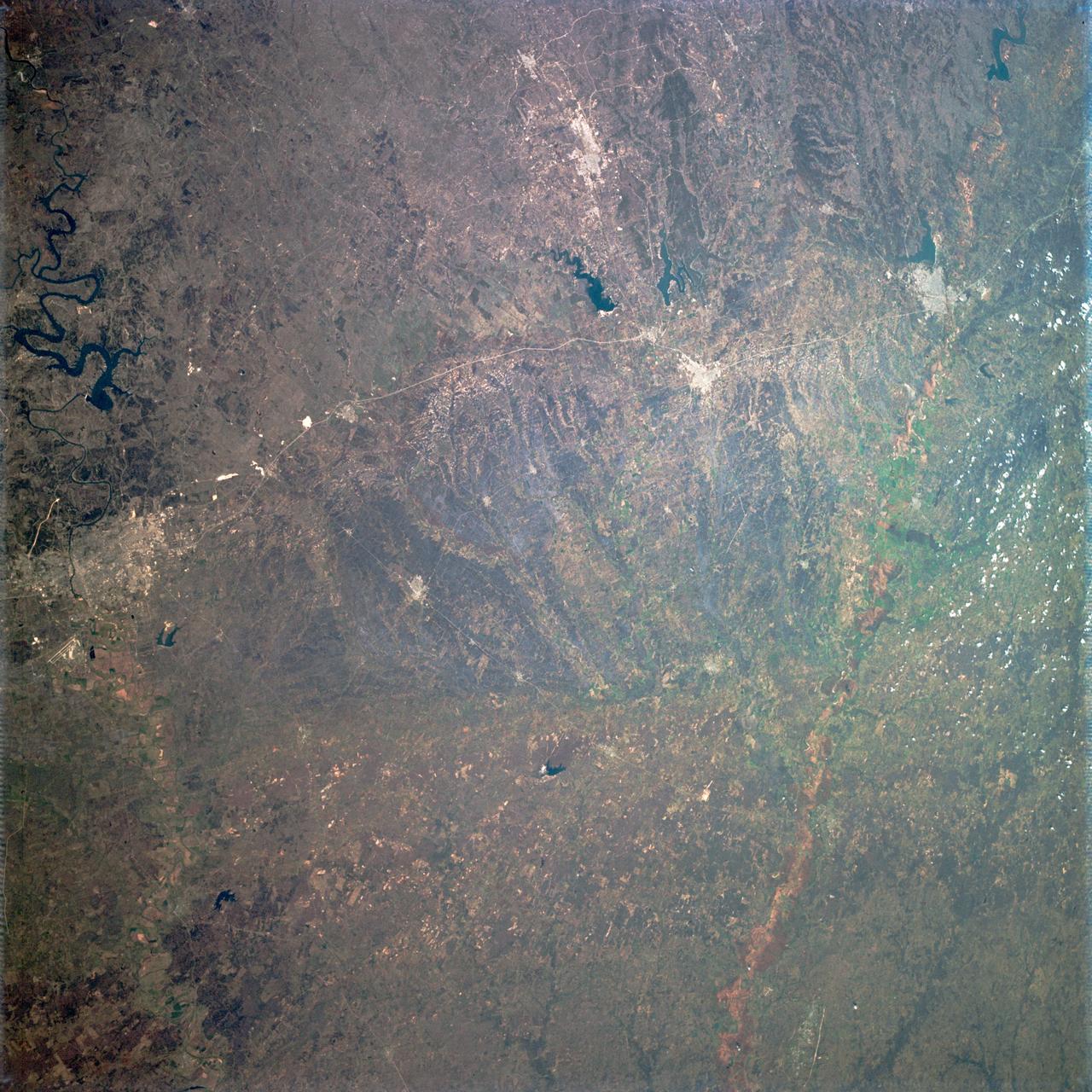
These images from NASA Terra satellite images of Oklahoma and north Texas were acquired on March 12, 2000 during Terra orbit 1243.
This image from NASA Terra spacecraft is of the Debra L. Friedkin archaeological site near Salado, Texas, a multicomponent site, with Clovis remains overlying pre-Clovis stone tools.
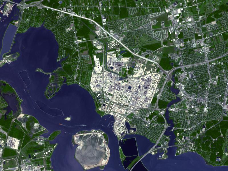
Acquired by NASA Terra spacecraft, this image shows ExxonMobil Baytown refinery in Texas. With a refining capacity of over 560,000 barrels per day, it is the largest refinery in the United States.
iss072e520778 (Jan. 23, 2025) --- The Houston-Galveston area with Trinity Bay, Galveston Bay, and Lake Livingston in Texas is pictured from the International Space Station as it orbited 259 miles above central Louisiana.
AS09-22-3463 (9 March 1969) --- Oblique view of the Houston, Texas area as photographed from the Apollo 9 spacecraft during its Earth-orbital mission. This picture was taken from an altitude of 103 nautical miles, at about 1:40 p.m. (CST), on March 9, 1969. Prominent features visible include highways leading out of the city, Lake Houston, San Jacinto River, Trinity Bay, Galveston Bay, Brazos River, Baytown, and Texas City.
Long regarded as one of the best photo of Houston, Texas (29.5N, 95.0W), this view from space shows the entire greater Houston/Galveston region in remarkable detail and clarity. The dark north/south line in the water between Houston and Galveston is the Houston Ship Channel. NASA's Johnson Space Center and Mission Control is located on the north shore of Clear Lake west of the channel. The extensive road and highway network can be seen in great detail.
S66-54558 (14 Sept. 1966) --- Del Rio and Eagle Pass area of the Rio Grande Valley of Texas and Mexico as seen from the Gemini-11 spacecraft during its 29th revolution of Earth. Photo credit: NASA
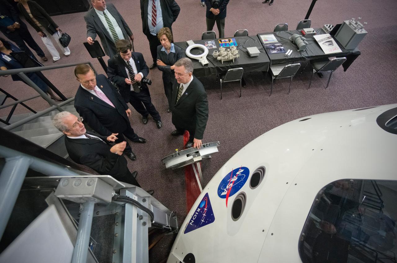
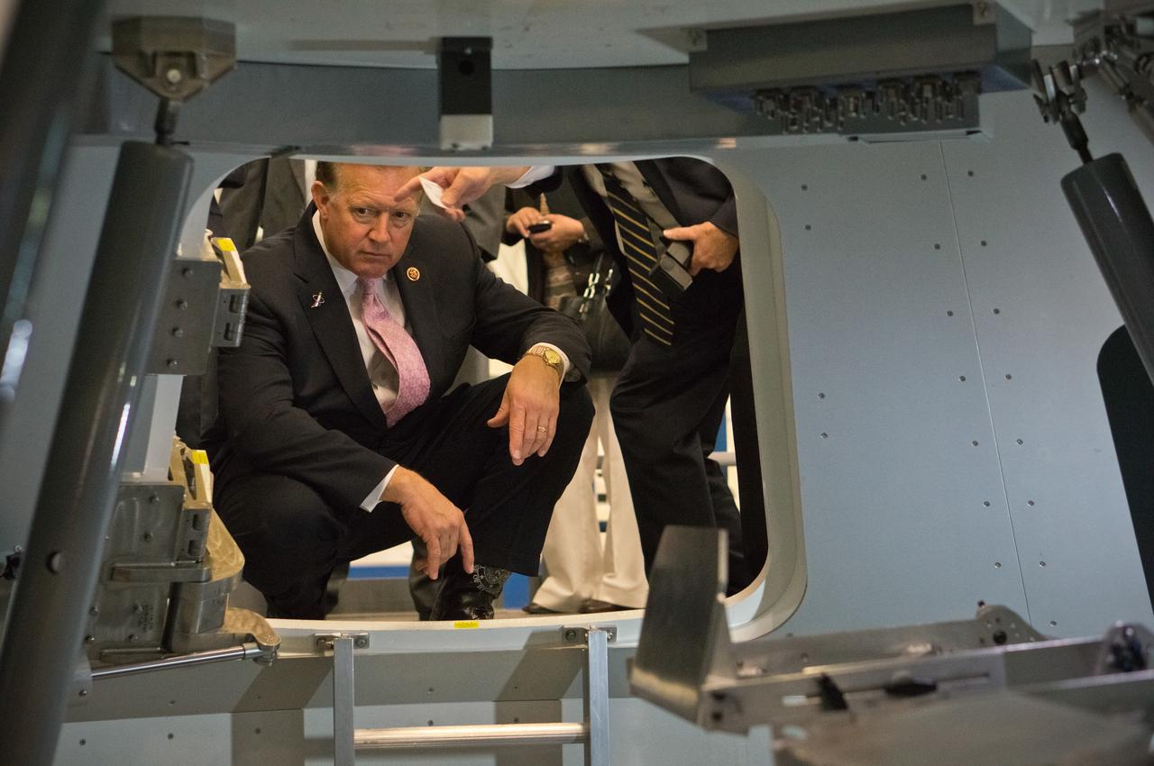
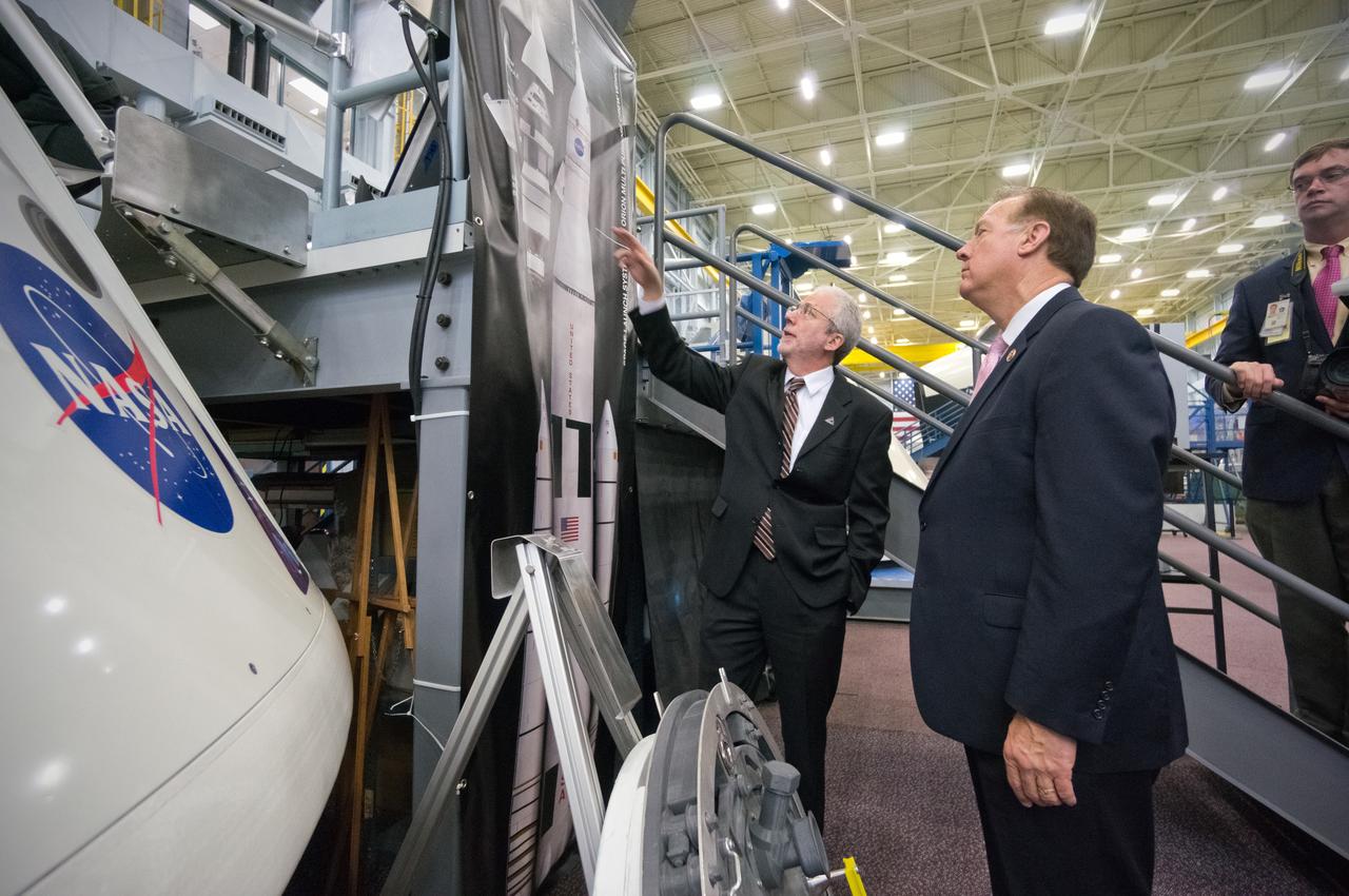
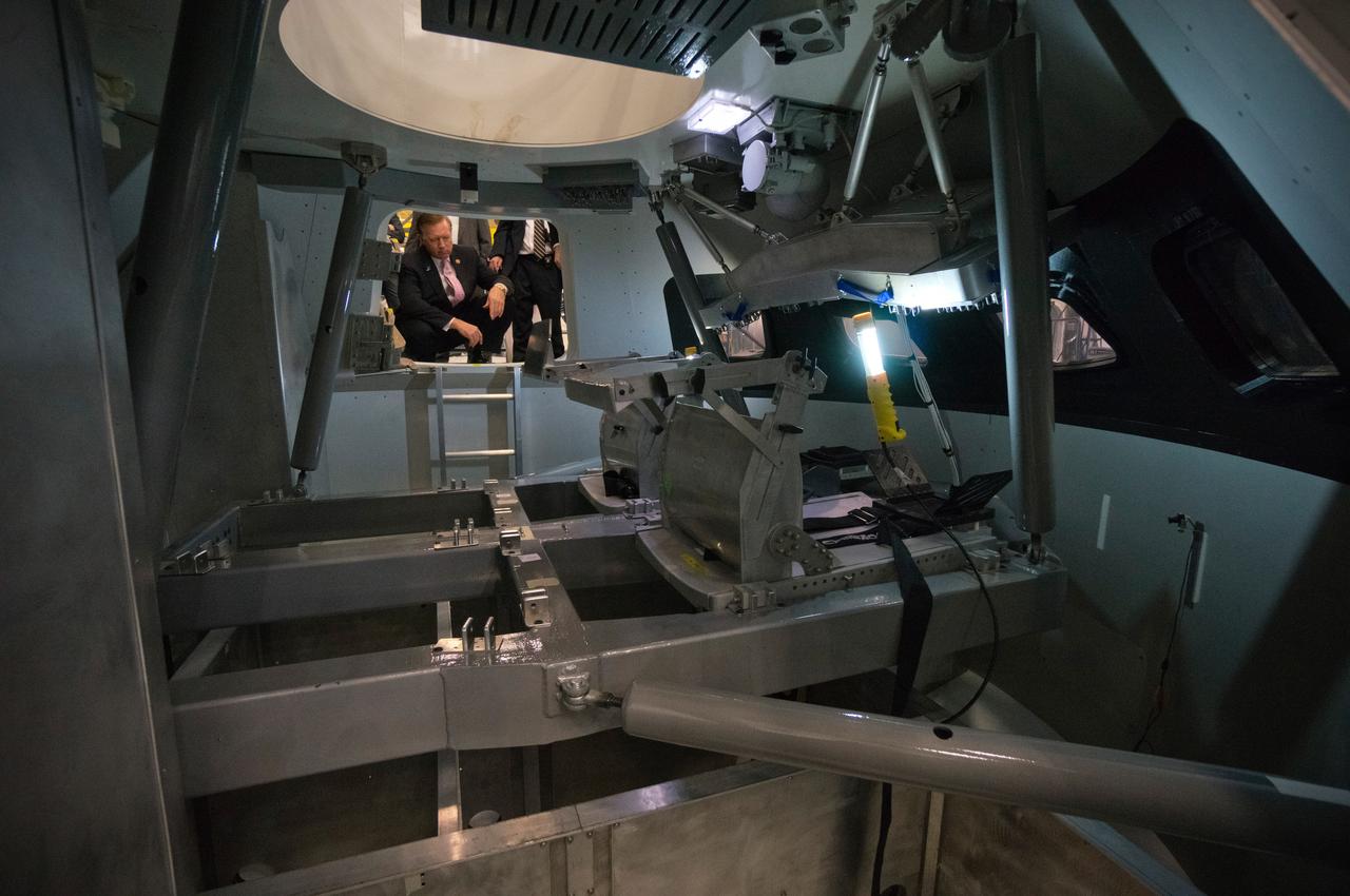
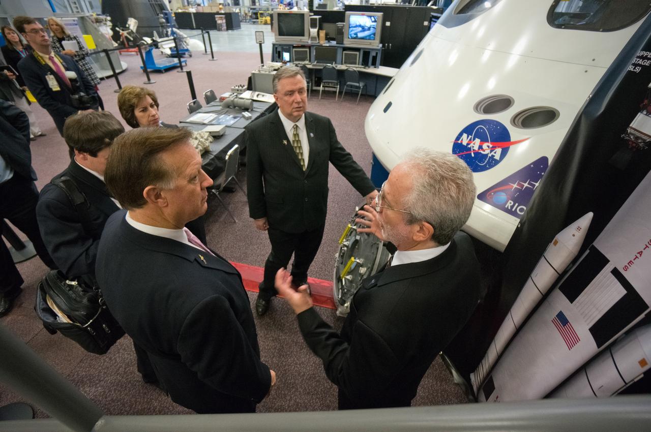
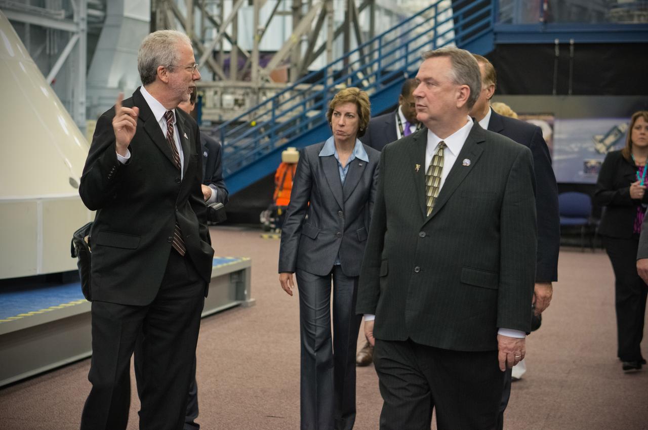
Congressman Steve Stockman, Texas 36th district, and Congressman Randy Weber, Texas 14th district, visit NASA’s Johnson Space Center in Houston on Feb. 20, 2013. Orion Program Manager Mark Geyer discussed the status and accomplishments of the Orion program. Part of Batch image transfer from Flickr.

Congressman Steve Stockman, Texas 36th district, and Congressman Randy Weber, Texas 14th district, visit NASA’s Johnson Space Center in Houston on Feb. 20, 2013. Orion Program Manager Mark Geyer discussed the status and accomplishments of the Orion program. Part of Batch image transfer from Flickr.
Congressman Steve Stockman, Texas 36th district, and Congressman Randy Weber, Texas 14th district, visit NASA’s Johnson Space Center in Houston on Feb. 20, 2013. Orion Program Manager Mark Geyer discussed the status and accomplishments of the Orion program. Part of Batch image transfer from Flickr.

Congressman Steve Stockman, Texas 36th district, and Congressman Randy Weber, Texas 14th district, visit NASA’s Johnson Space Center in Houston on Feb. 20, 2013. Orion Program Manager Mark Geyer discussed the status and accomplishments of the Orion program. Part of Batch image transfer from Flickr.

Congressman Steve Stockman, Texas 36th district, and Congressman Randy Weber, Texas 14th district, visit NASA’s Johnson Space Center in Houston on Feb. 20, 2013. Orion Program Manager Mark Geyer discussed the status and accomplishments of the Orion program. Part of Batch image transfer from Flickr.
Congressman Steve Stockman, Texas 36th district, and Congressman Randy Weber, Texas 14th district, visit NASA’s Johnson Space Center in Houston on Feb. 20, 2013. Orion Program Manager Mark Geyer discussed the status and accomplishments of the Orion program. Part of Batch image transfer from Flickr.
Congressman Steve Stockman, Texas 36th district, and Congressman Randy Weber, Texas 14th district, visit NASA’s Johnson Space Center in Houston on Feb. 20, 2013. Orion Program Manager Mark Geyer discussed the status and accomplishments of the Orion program. Part of Batch image transfer from Flickr.

Congressman Steve Stockman, Texas 36th district, and Congressman Randy Weber, Texas 14th district, visit NASA’s Johnson Space Center in Houston on Feb. 20, 2013. Orion Program Manager Mark Geyer discussed the status and accomplishments of the Orion program. Part of Batch image transfer from Flickr.

Congressman Steve Stockman, Texas 36th district, and Congressman Randy Weber, Texas 14th district, visit NASA’s Johnson Space Center in Houston on Feb. 20, 2013. Orion Program Manager Mark Geyer discussed the status and accomplishments of the Orion program. Part of Batch image transfer from Flickr.

Congressman Steve Stockman, Texas 36th district, and Congressman Randy Weber, Texas 14th district, visit NASA’s Johnson Space Center in Houston on Feb. 20, 2013. Orion Program Manager Mark Geyer discussed the status and accomplishments of the Orion program. Part of Batch image transfer from Flickr.

Congressman Steve Stockman, Texas 36th district, and Congressman Randy Weber, Texas 14th district, visit NASA’s Johnson Space Center in Houston on Feb. 20, 2013. Orion Program Manager Mark Geyer discussed the status and accomplishments of the Orion program. Part of Batch image transfer from Flickr.

Congressman Steve Stockman, Texas 36th district, and Congressman Randy Weber, Texas 14th district, visit NASA’s Johnson Space Center in Houston on Feb. 20, 2013. Orion Program Manager Mark Geyer discussed the status and accomplishments of the Orion program. Part of Batch image transfer from Flickr.
On June 15 at 19:15 UTC (3:15 p.m. EDT) the MODIS instrument aboard NASA's Aqua satellite captured a visible image of Tropical Storm Bill approaching Texas and Louisiana. Powerful thunderstorms circled the center in fragmented bands. At 11 a.m. CDT on June 16, a Tropical Storm Warning was in effect from Baffin Bay to High Island Texas as Bill was making landfall. The National Hurricane Center noted that Bill is expected to produce total rain accumulations of 4 to 8 inches over eastern Texas and eastern Oklahoma and 2 to 4 inches over western Arkansas and southern Missouri, with possible isolated maximum amounts of 12 inches in eastern Texas. In eastern Texas and far western Louisiana today and tonight, isolated tornadoes are also possible, as with any landfalling tropical storm. Tropical storm conditions are expected to continue into the evening in the warning area. Along the coasts, the combination of a storm surge and the tide will cause normally dry areas near the coast to be flooded by rising waters. The water could reach the following heights above ground if the peak surge occurs at the time of high tide. The NHC noted that the Upper Texas coast could experience 2 to 4 feet, and the western Louisiana coast between 1 to 2 feet. At 10 a.m. CDT (1500 UTC), the center of Tropical Storm Bill was located near latitude 28.2 North, longitude 96.4 West. Bill was moving toward the northwest near 10 mph (17 kph) and that general motion is expected to continue today. The latest minimum central pressure reported by an Air Force Reserve Hurricane Hunter aircraft was 997 millibars. Reports from an Air Force Reserve reconnaissance aircraft indicate that maximum sustained winds remain near 60 mph (95 kph) with higher gusts. Unlike Carlos, Bill is not a compact storm. Tropical-storm-force winds extend outward up to 150 miles (240 km) from the center. Between 9 and 10 a.m. CDT, an automated observing station at Port O'Connor also reported a sustained wind of 44 mph (70 kph) and a gust to 53 mph (85 kph). For updated forecasts, watches and warnings, visit the National Hurricane Center webpage at <a href="http://www.nhc.noaa.gov" rel="nofollow">www.nhc.noaa.gov</a>. For local forecasts and advisories, visit: <a href="http://www.weather.gov" rel="nofollow">www.weather.gov</a>. Bill is forecast to continue moving inland and is expected to be a tropical depression by Wednesday, June 17, west of Dallas. The remnants of Bill are forecast to move into the Midwest later in the week. Credit: NASA/GSFC/Jeff Schmaltz/MODIS Land Rapid Response Team <b><a href="http://www.nasa.gov/audience/formedia/features/MP_Photo_Guidelines.html" rel="nofollow">NASA image use policy.</a></b> <b><a href="http://www.nasa.gov/centers/goddard/home/index.html" rel="nofollow">NASA Goddard Space Flight Center</a></b> enables NASA’s mission through four scientific endeavors: Earth Science, Heliophysics, Solar System Exploration, and Astrophysics. Goddard plays a leading role in NASA’s accomplishments by contributing compelling scientific knowledge to advance the Agency’s mission. <b>Follow us on <a href="http://twitter.com/NASAGoddardPix" rel="nofollow">Twitter</a></b> <b>Like us on <a href="http://www.facebook.com/pages/Greenbelt-MD/NASA-Goddard/395013845897?ref=tsd" rel="nofollow">Facebook</a></b> <b>Find us on <a href="http://instagrid.me/nasagoddard/?vm=grid" rel="nofollow">Instagram</a></b>
51J-143-126 (5 Oct. 1985) --- The vertical stabilizer of the Earth-orbiting Space Shuttle Atlantis serves to partially frame this scene of Metropolitan Houston. Hold photo with vertical tail at top so that north will be at top. America's fourth largest city, with its radiating highway network, lies at the junction between the East Texas piney woods, containing lakes Conroe and Livingston (near top center and top right, respectively), and the coastal prairie, now largely farmland (left side of frame). The coast stretches from the left at Freeport and the mouth of the Brazos River, past Galveston and Texas City, and the circle of the High Island Salt Dome (clearly seen at lower right near the Bolivar Peninsula), to Port Arthur on the Neches River (far right). Patterns of muddy and clear water are particularly well-displayed in Galveston and Trinity Bays, as well as in the Gulf of Mexico. With a close look, the Harris County Domed Stadium (Astrodome) can be recognized on Houston's south side. The NASA Johnson Space Center (JSC) and the Clear Lake City area are easily delineated some 25 miles southeast of downtown Houston. The scene was recorded on film by one of the STS-51J crewmembers using a handheld Hasselblad camera and 70mm film.
Frisco, Texas is a city in the Dallas-Fort Worth metroplex, located about 40 km (24.9 mi) northeast of the Dallas/Fort Worth International Airport. Founded in 1860 along the Shawnee Trail, the town has become a bedroom community for workers in Dallas-Fort Worth. The city saw explosive growth between April 9, 1984 when the Landsat TM image was acquired, and April 15, 2018 when the ASTER image was acquired. Population grew from 4,500 to 174,000. The images cover an area of 27 by 34.5 km (16.7 by 21.4 mi), and are located at 33.1 degrees north, 96.8 degrees west. https://photojournal.jpl.nasa.gov/catalog/PIA22552

The Livermore and Spring Ranch fires near the Davis Mountain Resort, Texas, burned 13,000 and 11,000 acres respectively. When NASA Terra spacecraft acquired this image on May 12, 2012, both fires had been contained.
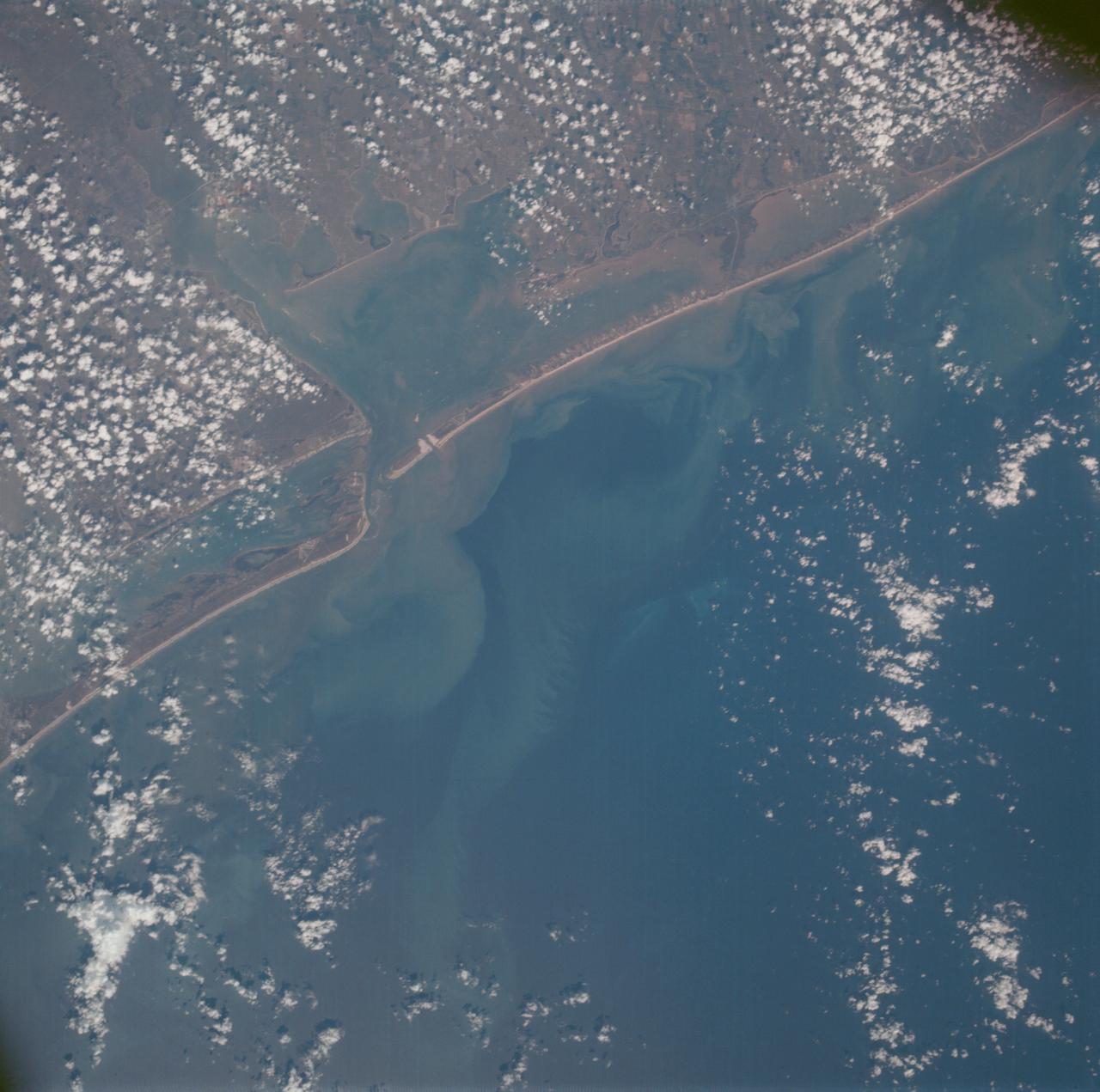
AS07-07-1800 (15 Oct. 1968) --- Matagorda Bay area on the Gulf Coast of Texas as seen from the Apollo 7 spacecraft during its 62nd revolution of Earth. Photographed from an altitude of 90 nautical miles, at ground elapsed time of 98 hours and 38 minutes.
AS09-22-3341 (3-13 March 1969) --- Central Texas area as photographed from the Apollo 9 spacecraft during its Earth-orbital mission. Interstate 35 runs from Austin (right center edge of picture) to Waco (near bottom left corner). Also visible are the cities of Georgetown, Taylor, Temple and Killeen. The Colorado River runs through Austin. The Brazos River flows through Waco. Lake Travis is upstream from Austin. Lake Whitney is at bottom left corner of picture. The Belton Reservoir is near bottom center. The lake formed by the dam on the Lampasas River near Belton is also clearly visible.

NASA Astronaut Frank Rubio smiles during a spacewalk robotics training on May 11, 2022 in Building 9 of NASA's Johnson Space Center in Houston, Texas.

Congressman Steve Stockman, Texas 36th district, and Congressman Randy Weber, Texas 14th district, visit NASA’s Johnson Space Center in Houston on Feb. 20, 2013. Orion Program Manager Mark Geyer and Johnson Space Center Director Dr. Ellen Ochoa discussed the status and accomplishments of the Orion program. Part of Batch image transfer from Flickr.

Congressman Steve Stockman, Texas 36th district, and Congressman Randy Weber, Texas 14th district, visit NASA’s Johnson Space Center in Houston on Feb. 20, 2013. Orion Program Manager Mark Geyer and Johnson Space Center Director Dr. Ellen Ochoa discussed the status and accomplishments of the Orion program. Part of Batch image transfer from Flickr.
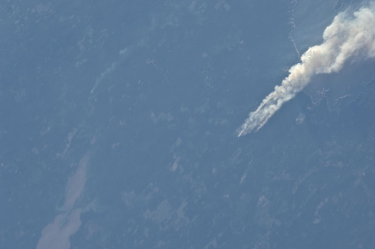
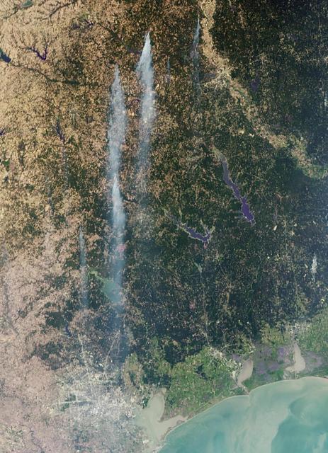
ISS028-E-008377 (21 June 2011) --- One of the Expedition 28 crew members aboard the International Space Station, flying at an altitude of approximately 235 statute miles, on June 21 spotted and photographed this image of one of the major Texas wildfires currently burning up massive acreage. This one is near Jasper and Lake Sam Rayburn in far east Texas.

Congressman Steve Stockman, Texas 36th district, and Congressman Randy Weber, Texas 14th district, visit NASA’s Johnson Space Center in Houston on Feb. 20, 2013. Orion Program Manager Mark Geyer and Johnson Space Center Director Dr. Ellen Ochoa discussed the status and accomplishments of the Orion program. Part of Batch image transfer from Flickr.

Congressman Steve Stockman, Texas 36th district, and Congressman Randy Weber, Texas 14th district, visit NASA’s Johnson Space Center in Houston on Feb. 20, 2013. Orion Program Manager Mark Geyer and Johnson Space Center Director Dr. Ellen Ochoa discussed the status and accomplishments of the Orion program. Part of Batch image transfer from Flickr.
ISS028-E-008374 (21 June 2011) --- One of the Expedition 28 crew members aboard the International Space Station, flying at an altitude of approximately 235 statute miles, on June 21 spotted and photographed this image of one of the major Texas wildfires currently burning up massive acreage. This one is near Jasper and Lake Sam Rayburn in far east Texas.
ISS028-E-008373 (21 June 2011) --- One of the Expedition 28 crew members aboard the International Space Station, flying at an altitude of approximately 235 statute miles, on June 21 spotted and photographed this image of one of the major Texas wildfires currently burning up massive acreage. This one is near Jasper and Lake Sam Rayburn in far east Texas.
Congressman Steve Stockman, Texas 36th district, and Congressman Randy Weber, Texas 14th district, visit NASA’s Johnson Space Center in Houston on Feb. 20, 2013. Orion Program Manager Mark Geyer and Johnson Space Center Director Dr. Ellen Ochoa discussed the status and accomplishments of the Orion program. Part of Batch image transfer from Flickr.
Congressman Steve Stockman, Texas 36th district, and Congressman Randy Weber, Texas 14th district, visit NASA’s Johnson Space Center in Houston on Feb. 20, 2013. Orion Program Manager Mark Geyer and Johnson Space Center Director Dr. Ellen Ochoa discussed the status and accomplishments of the Orion program. Part of Batch image transfer from Flickr.
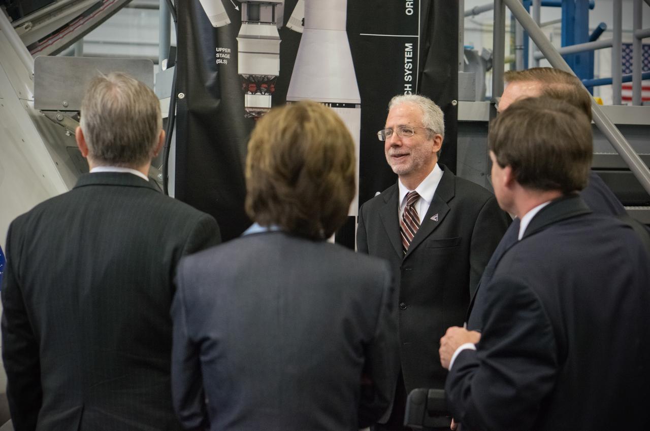
Congressman Steve Stockman, Texas 36th district, and Congressman Randy Weber, Texas 14th district, visit NASA’s Johnson Space Center in Houston on Feb. 20, 2013. Orion Program Manager Mark Geyer and Johnson Space Center Director Dr. Ellen Ochoa discussed the status and accomplishments of the Orion program. Part of Batch image transfer from Flickr.
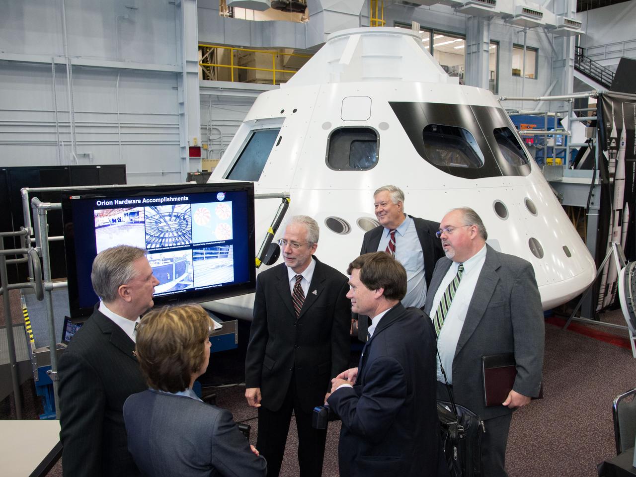
Congressman Steve Stockman, Texas 36th district, and Congressman Randy Weber, Texas 14th district, visit NASA’s Johnson Space Center in Houston on Feb. 20, 2013. Orion Program Manager Mark Geyer and Johnson Space Center Director Dr. Ellen Ochoa discussed the status and accomplishments of the Orion program. Part of Batch image transfer from Flickr.

NASA Astronaut Frank Rubio addresses a colleague during a spacewalk robotics training on May 11, 2022 in Building 9 of NASA's Johnson Space Center in Houston, Texas.
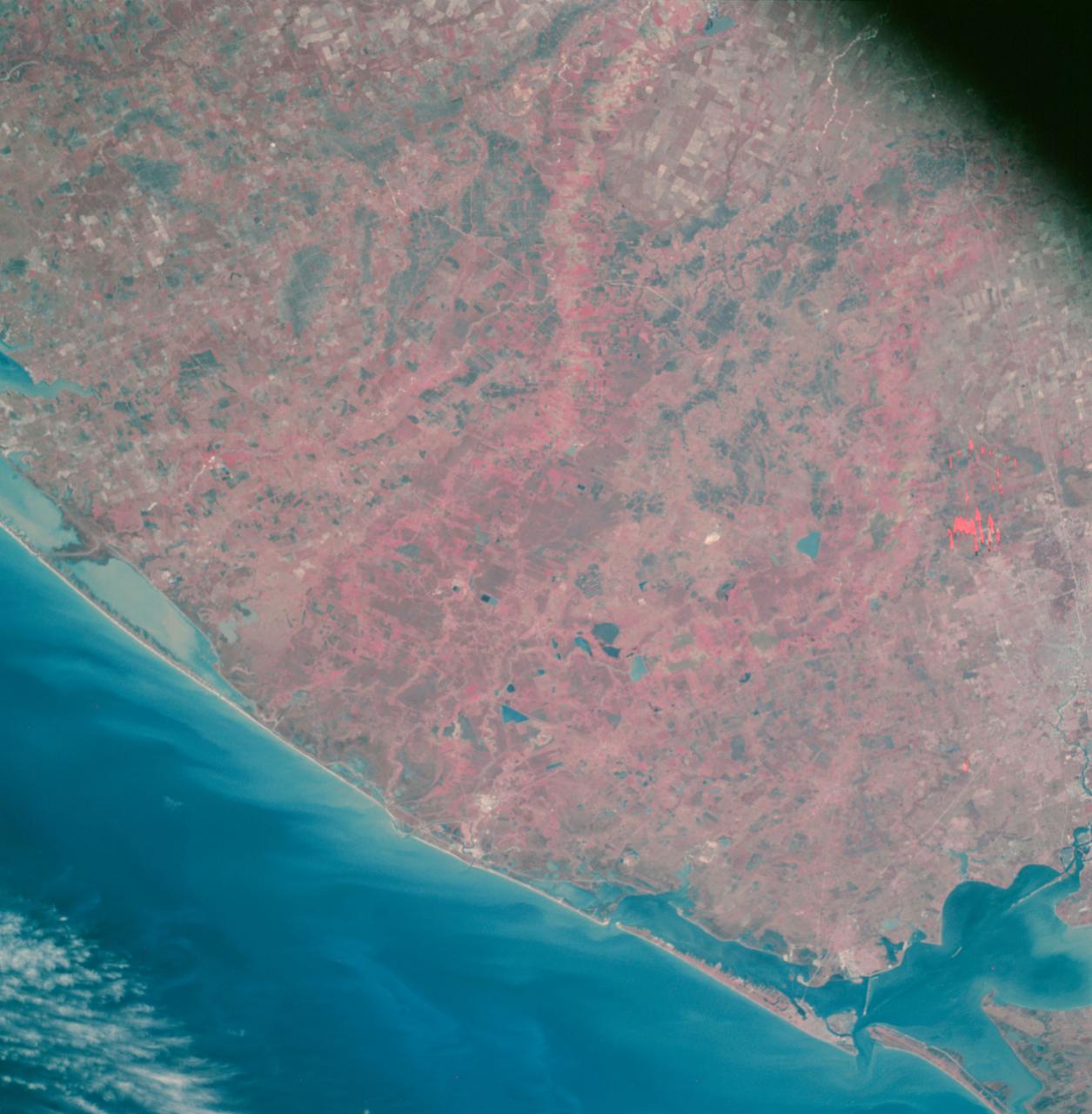
The tri-county Riley Road wildfire burning in Texas north of Houston was 85 percent contained when NASA Terra spacecraft acquired this image on Sept. 12, 2011. Burned areas are dark gray and black; vegetation red; and bare ground and roads light gray.
AS07-07-1872 (11-22 Oct. 1968) --- The Houston, Texas, and Gulf Coast area, looking southeast, as seen from the Apollo 7 spacecraft at an altitude of 101 nautical miles. This photograph was made during the spacecraft's 91st revolution of Earth, at ground elapsed time of 144 hours and 26 minutes. The morning sun causes a spectacular reflection on water surfaces such as the Gulf of Mexico, Galveston Bay, Buffalo Bayou, and the Brazos River, and causes a unique reflection in the canals and rice fields west of Alvin. Some of the landmarks visible in this picture include highways and freeways, the Astrodome, the new Intercontinental Airport, and the Manned Spacecraft Center.

AS06-02-1462 (4 April 1968) --- View of the Dallas-Fort Worth, Texas, area as photographed from the unmanned Apollo 6 (Spacecraft 020/Saturn 502) space mission. The highway and expressway system in and around both cities is clearly visible. North is toward left side of picture. Grapevine Reservoir and Garza-Little Elm Reservoir are to the north-west of Dallas. The city of Denton can be seen in left center of picture at conjunction of highways leading to both Fort Worth and Dallas. The Brazos River is in lower right corner. This photograph was made three hours and nine minutes after liftoff of the Apollo 6 space flight.
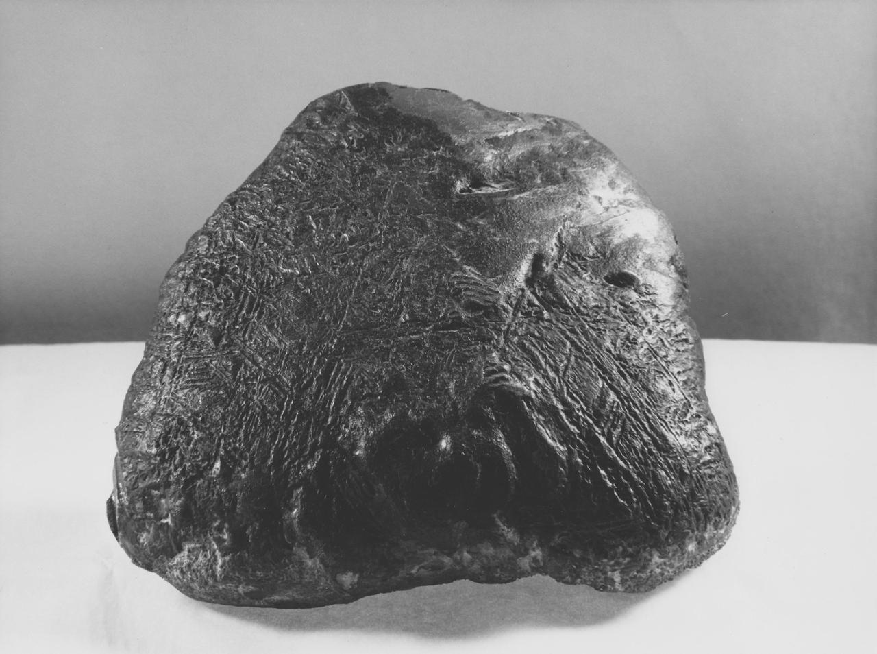
This iron-nickel meteorite found near Fort Stockton, Texas, in 1952 shows a surface texture similar to some portions of the surface of an iron-nickel meteorite that NASA Mars Exploration Rover Opportunity found on Mars in July, 2009.
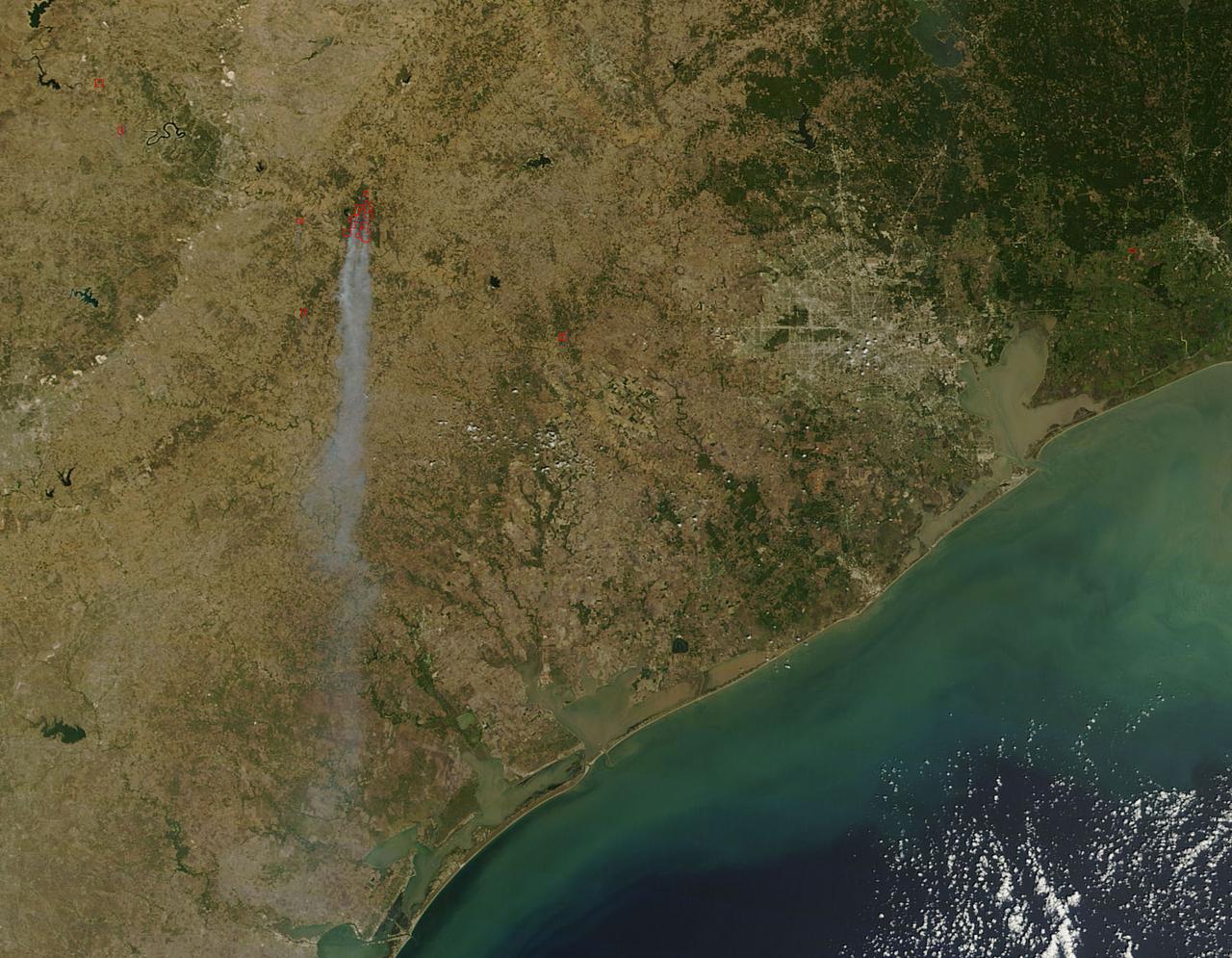
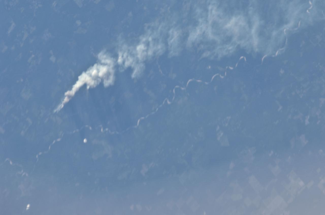
As the remains of Tropical Storm Lee passed over Louisiana on Monday, Sept. 5, 2011, strong, gusty winds on the western side of the storm stoked fires throughout eastern Texas as seen in this image from NASA Terra spacecraft.
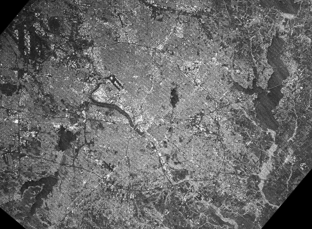
This radar image acquired by NASA Shuttle Radar Topography Mission SRTM from data collected on February 18, 2000 shows the Dallas-Fort Worth metropolitan area in Texas.
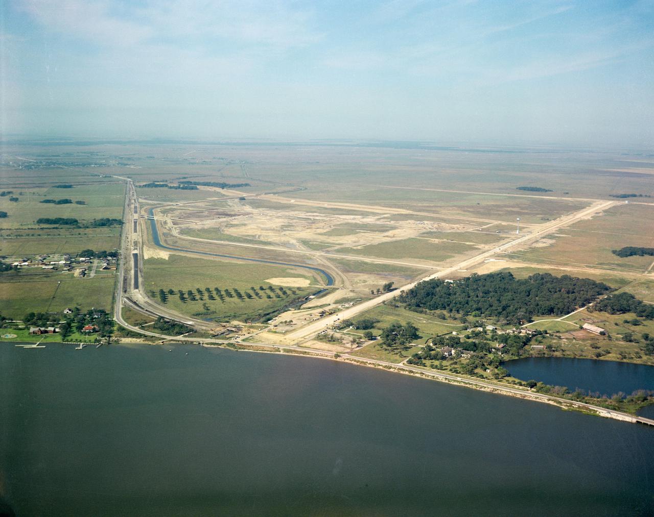
S62-08046 (1961) --- Aerial view of the future site of the Manned Spacecraft Center, Houston, Texas. NOTE: The Manned Spacecraft Center was named Lyndon B. Johnson Space Center in memory of the late President following his death.

NASA Astronaut Frank Rubio trains for his upcoming International Space Station mission in a T-38 jet at Ellington Field in Houston, Texas.

NASA Astronaut Frank Rubio trains for his upcoming International Space Station mission in a T-38 jet at Ellington Field in Houston, Texas.
ISS028-E-008375 (21 June 2011) --- One of the Expedition 28 crew members aboard the International Space Station, flying at an altitude of approximately 235 statute miles, on June 21 spotted and photographed this image of one of the major Texas wildfires currently burning up massive acreage. This one is near the Sabine River, southeast of Kirbyville.
In this view of Houston/Galveston, Texas, USA (29.5N, 95.5W), heavy spring rains emphasize the several bodies of water in the area. Even though partially cloud covered, the progressive nature of the Houston highway and freeway system can easily be observed in this highly detailed view. To the south, the NASA, Clear Lake area just off of Galveston Bay can easily be seen. In the center, is the downtown business district.
AS09-23-3561 (3-13 March 1969) --- Near vertical view of the Lubbock area in west Texas as photographed from the Apollo 9 spacecraft during its Earth-orbital mission. Conspicuous patterns of farmland surround the city and extend eastward (up) to the Caprock Escarpment. The Double Mountain fork of the Brazos River drains east (toward upper center); Leeland is at lower center; Brownfield at lower right. The sharp edge of a cloud disk cuts across the upper right corner.
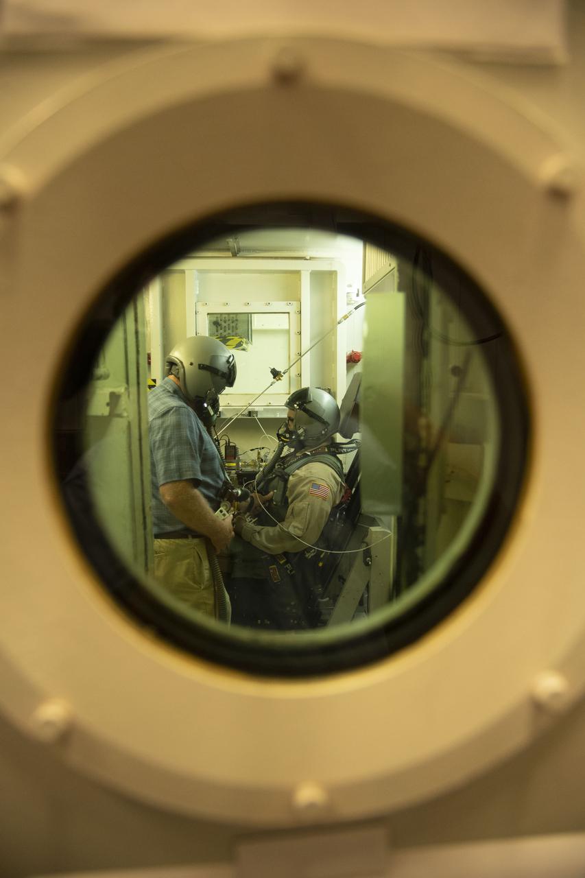
The low pressure (hypobaric) chamber at KBR’s facility in San Antonio, Texas, simulates very high altitudes by reducing the air pressure inside of the chamber. The subject inside the chamber experiences the reduced pressure conditions that exist at higher altitudes, in this case altitudes up to 60,000 feet.
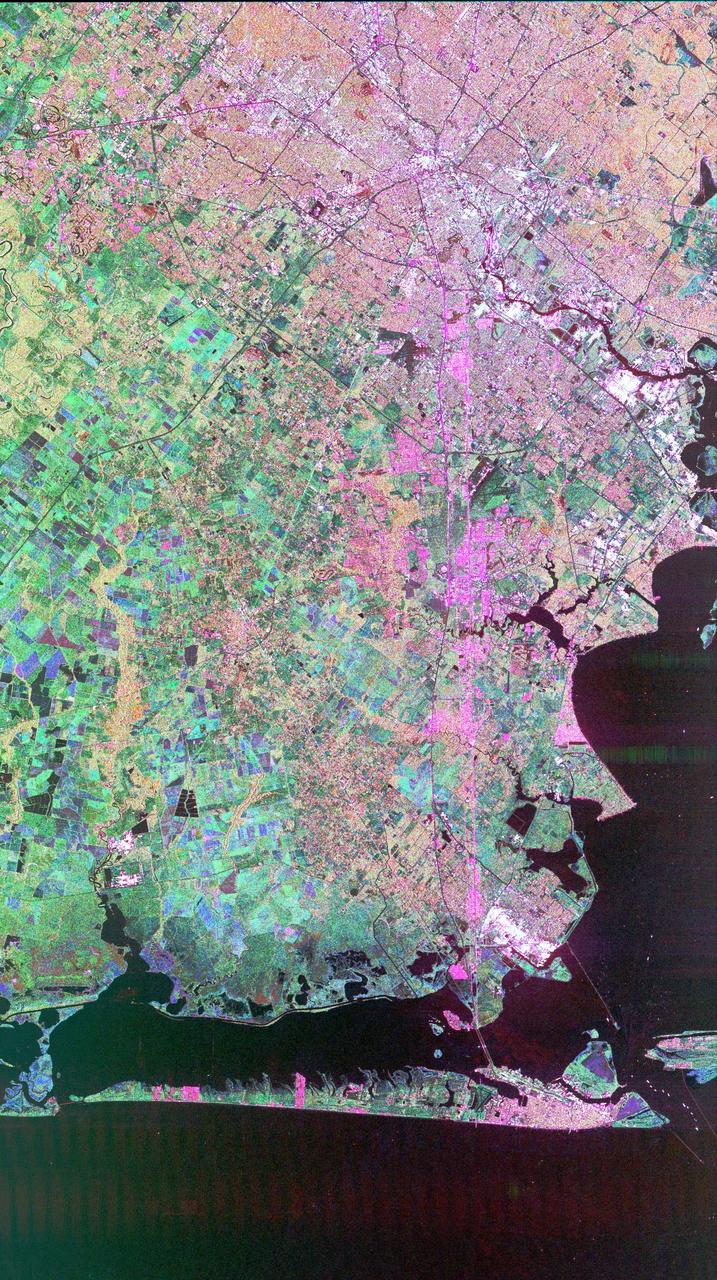
This image of Houston, Texas, shows the amount of detail that is possible to obtain using spaceborne radar imaging. Images such as this -- obtained by the Spaceborne Imaging Radar-C/X-band Synthetic Aperture Radar (SIR-C/X-SAR) flying aboard the space shuttle Endeavor last fall -- can become an effective tool for urban planners who map and monitor land use patterns in urban, agricultural and wetland areas. Central Houston appears pink and white in the upper portion of the image, outlined and crisscrossed by freeways. The image was obtained on October 10, 1994, during the space shuttle's 167th orbit. The area shown is 100 kilometers by 60 kilometers (62 miles by 38 miles) and is centered at 29.38 degrees north latitude, 95.1 degrees west longitude. North is toward the upper left. The pink areas designate urban development while the green-and blue-patterned areas are agricultural fields. Black areas are bodies of water, including Galveston Bay along the right edge and the Gulf of Mexico at the bottom of the image. Interstate 45 runs from top to bottom through the image. The narrow island at the bottom of the image is Galveston Island, with the city of Galveston at its northeast (right) end. The dark cross in the upper center of the image is Hobby Airport. Ellington Air Force Base is visible below Hobby on the other side of Interstate 45. Clear Lake is the dark body of water in the middle right of the image. The green square just north of Clear Lake is Johnson Space Center, home of Mission Control and the astronaut training facilities. The black rectangle with a white center that appears to the left of the city center is the Houston Astrodome. The colors in this image were obtained using the follow radar channels: red represents the L-band (horizontally transmitted, vertically received); green represents the C-band (horizontally transmitted, vertically received); blue represents the C-band (horizontally transmitted and received). http://photojournal.jpl.nasa.gov/catalog/PIA01783
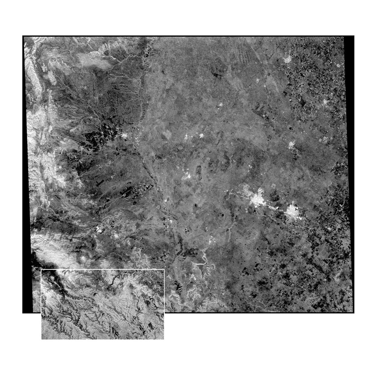
This radar image of the Midland/Odessa region of West Texas, demonstrates an experimental technique, called ScanSAR, that allows scientists to rapidly image large areas of the Earth's surface. The large image covers an area 245 kilometers by 225 kilometers (152 miles by 139 miles). It was obtained by the Spaceborne Imaging Radar-C/X-Band Synthetic Aperture Radar (SIR-C/X-SAR) flying aboard the space shuttle Endeavour on October 5, 1994. The smaller inset image is a standard SIR-C image showing a portion of the same area, 100 kilometers by 57 kilometers (62 miles by 35 miles) and was taken during the first flight of SIR-C on April 14, 1994. The bright spots on the right side of the image are the cities of Odessa (left) and Midland (right), Texas. The Pecos River runs from the top center to the bottom center of the image. Along the left side of the image are, from top to bottom, parts of the Guadalupe, Davis and Santiago Mountains. North is toward the upper right. Unlike conventional radar imaging, in which a radar continuously illuminates a single ground swath as the space shuttle passes over the terrain, a Scansar radar illuminates several adjacent ground swaths almost simultaneously, by "scanning" the radar beam across a large area in a rapid sequence. The adjacent swaths, typically about 50 km (31 miles) wide, are then merged during ground processing to produce a single large scene. Illumination for this L-band scene is from the top of the image. The beams were scanned from the top of the scene to the bottom, as the shuttle flew from left to right. This scene was acquired in about 30 seconds. A normal SIR-C image is acquired in about 13 seconds. The ScanSAR mode will likely be used on future radar sensors to construct regional and possibly global radar images and topographic maps. The ScanSAR processor is being designed for 1996 implementation at NASA's Alaska SAR Facility, located at the University of Alaska Fairbanks, and will produce digital images from the forthcoming Canadian RADARSAT satellite. http://photojournal.jpl.nasa.gov/catalog/PIA01787
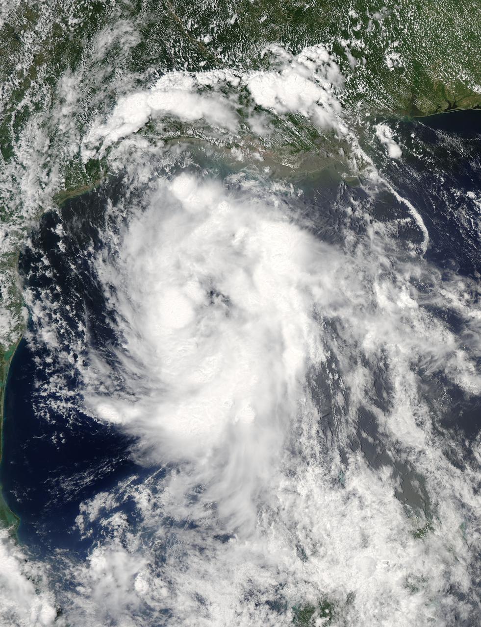
NASA Aqua spacecraft passed over Tropical Storm Don at 8:17 UTC 1:17 a.m. EDT on July 29, 2011. Texas is experiencing exceptional drought conditions; Tropical Storm Don may bring relief.
iss073e0123876 (May 19, 2025) --- The Gulf of America coast lit by the city lights from Houston, Texas, (upper left) to the Florida peninsula and an atmospheric glow crowning Earth's atmosphere are pictured from the International Space Station as it orbited 260 miles above the Lone Star State.
AS09-26A-3727A (8 March 1969) --- Color infrared photograph of the Texas Gulf Coast, Galveston Bay to Matagorda Bay, as seen from the Apollo 9 spacecraft during it 78th revolution of Earth. Houston is located at right center edge of photograph. Also visible are Galveston, Texas City, Manned Spacecraft Center, and Freeport. The mouth of the Colorado River is located near left center edge of picture. This picture was taken as a part of the SO65 Multispectral Terrain Photography Experiment.
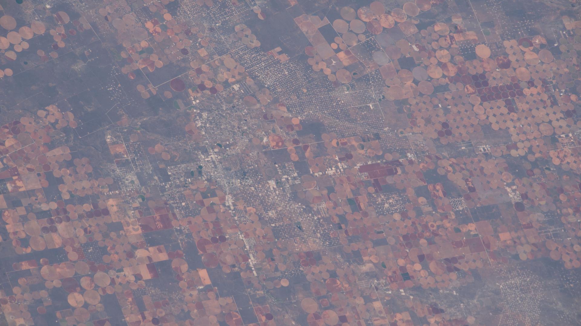
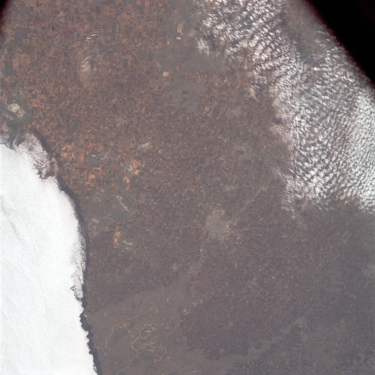
iss074e0603632 (May 16, 2026) --- Industrial-scale farming and oil production exist side-by-side and compete for land and water resources in western Texas. The crop circles are center-pivot irrigation systems used to cultivate cotton, sorghum, wheat, hay, and corn. The grid set against the circular farms is a dense network of well sites, pipelines, and roads that support the petroleum infrastructure. The International Space Station was orbiting 259 miles above the Texas–Oklahoma border at the time of this photograph. Credit: NASA
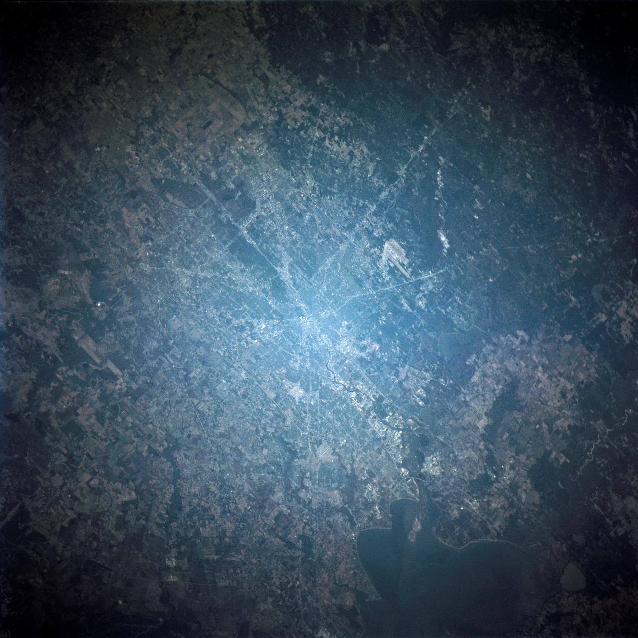
STS109-714-035 (1-12 March 2002) --- The astronauts on board the Space Shuttle Columbia took this 70mm picture featuring the greater metropolitan Houston, Texas area. The view direction is northwest, with Houston's downtown as the brightest region (center) where major highways converge. Interstate 10 is a fine line extending towards the lower right, around the north side of Galveston Bay, part of which appears in the lower right corner. The interstate also appears as a line cutting through the wooded parts of west Houston (just west of downtown). Bush Intercontinental Airport is the largest light patch on the view north of downtown, and lies next to Highway 59, a thin white line that stretches toward the right side of the picture. Forests of East Texas make the top right corner of the view a dark green.
Retired NASA astronaut Scott Kelly poses a portrait, Monday, July 8, 2019 at NASA's Johnson Space Center in Houston, Texas. Photo Credit: (NASA/Bill Ingalls)
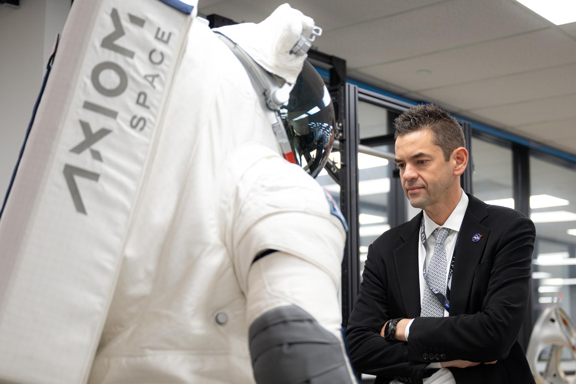
NASA Administrator Jared Isaacman tours Axiom Space's extravehicular activity and spacesuit facility, Friday, Jan. 23, 2026, in Houston, Texas. Photo Credit: (NASA/John Kraus)
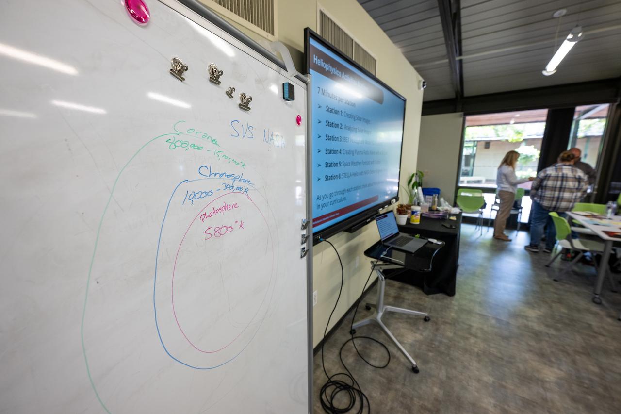
A diagram is seen during a teacher professional development event hosted by the NASA Heliophysics Education Activation Team (HEAT) at the Dallas Arboretum, Saturday, April 6, 2024, in Dallas, Texas. Photo Credit: (NASA/Keegan Barber)
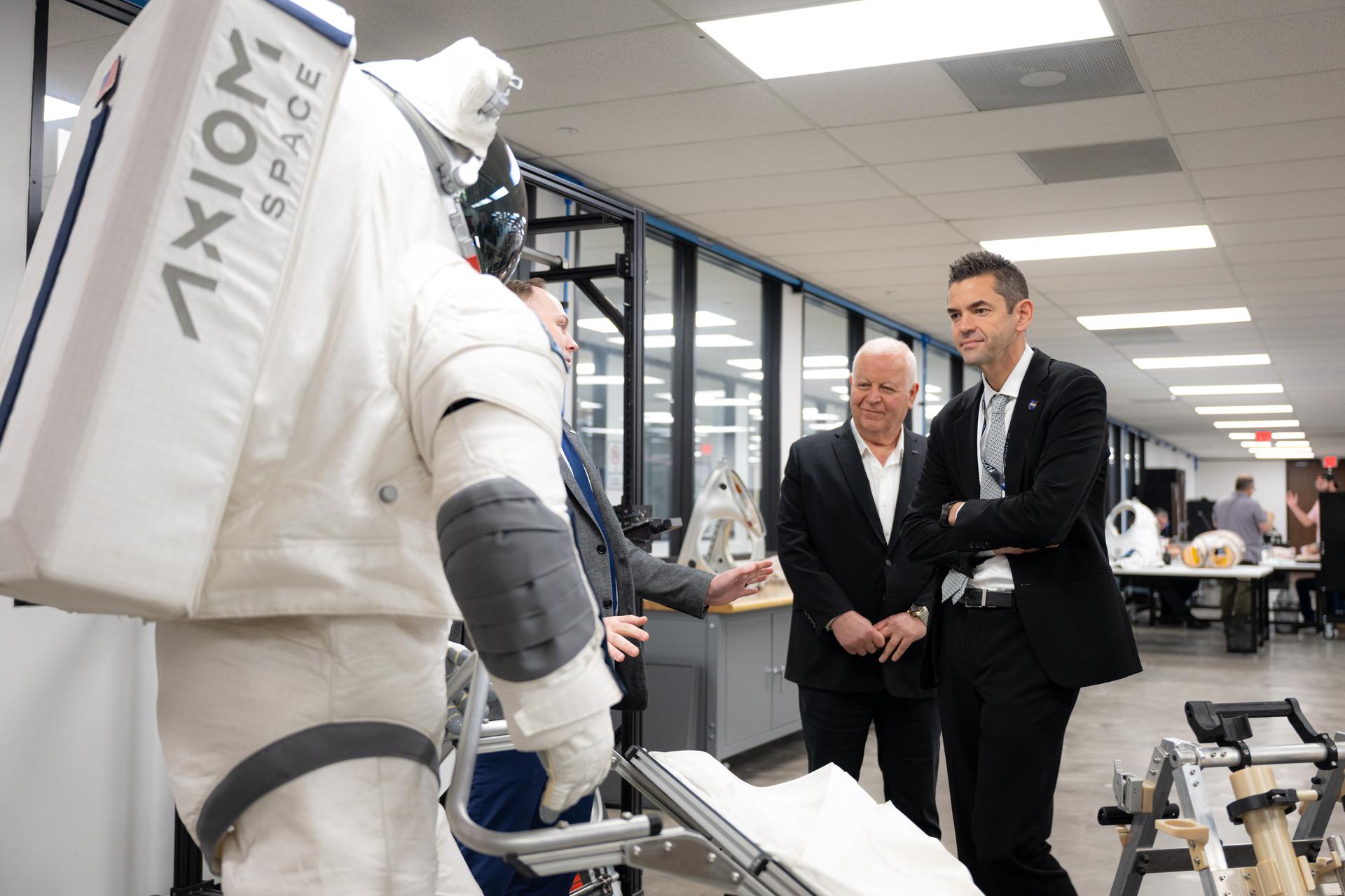
NASA Administrator Jared Isaacman, right, and Axiom Space leadership tour the company's extravehicular activity and spacesuit facility, Friday, Jan. 23, 2026, in Houston, Texas. Photo Credit: (NASA/John Kraus)

NASA astronaut Don Pettit poses for a portrait after donning his spacesuit, Friday, July 12, 2019 at NASA's Johnson Space Center in Houston, Texas. Photo Credit: (NASA/Bill Ingalls)

Mark Geyer, Director of NASA's Johnson Space Center, delivers remarks in the Teague Auditorium at NASA's Johnson Space Center, Thursday, Aug. 23, 2018 in Houston, Texas. Photo Credit: (NASA/Joel Kowsky)
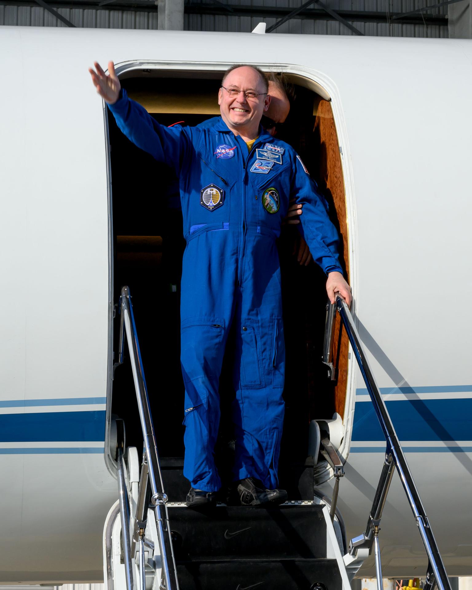
jsc2026e002116 (Jan. 16, 2025) --- NASA astronaut and SpaceX Crew-11 Pilot Mike Fincke waves to officials at Ellington Field in Houston, Texas. He departed the International Space Station and returned to Earth the day before aboard the Dragon spacecraft for a parachute-assisted splashdown off the coast of San Diego, California. Credit: NASA/Robert Markowitz
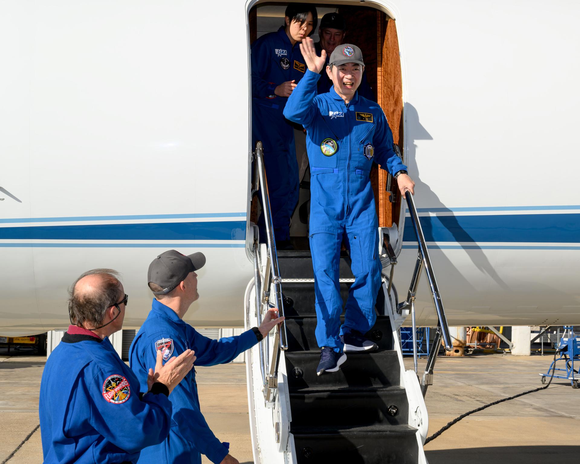
jsc2026e002115 (Jan. 16, 2025) --- JAXA (Japan Aerospace Exploration Agency) astronaut and SpaceX Crew-11 Mission Specialist Kimiya Yui waves to officials at Ellington Field in Houston, Texas. He departed the International Space Station and returned to Earth the day before aboard the Dragon spacecraft for a parachute-assisted splashdown off the coast of San Diego, California. Credit: NASA/Robert Markowitz
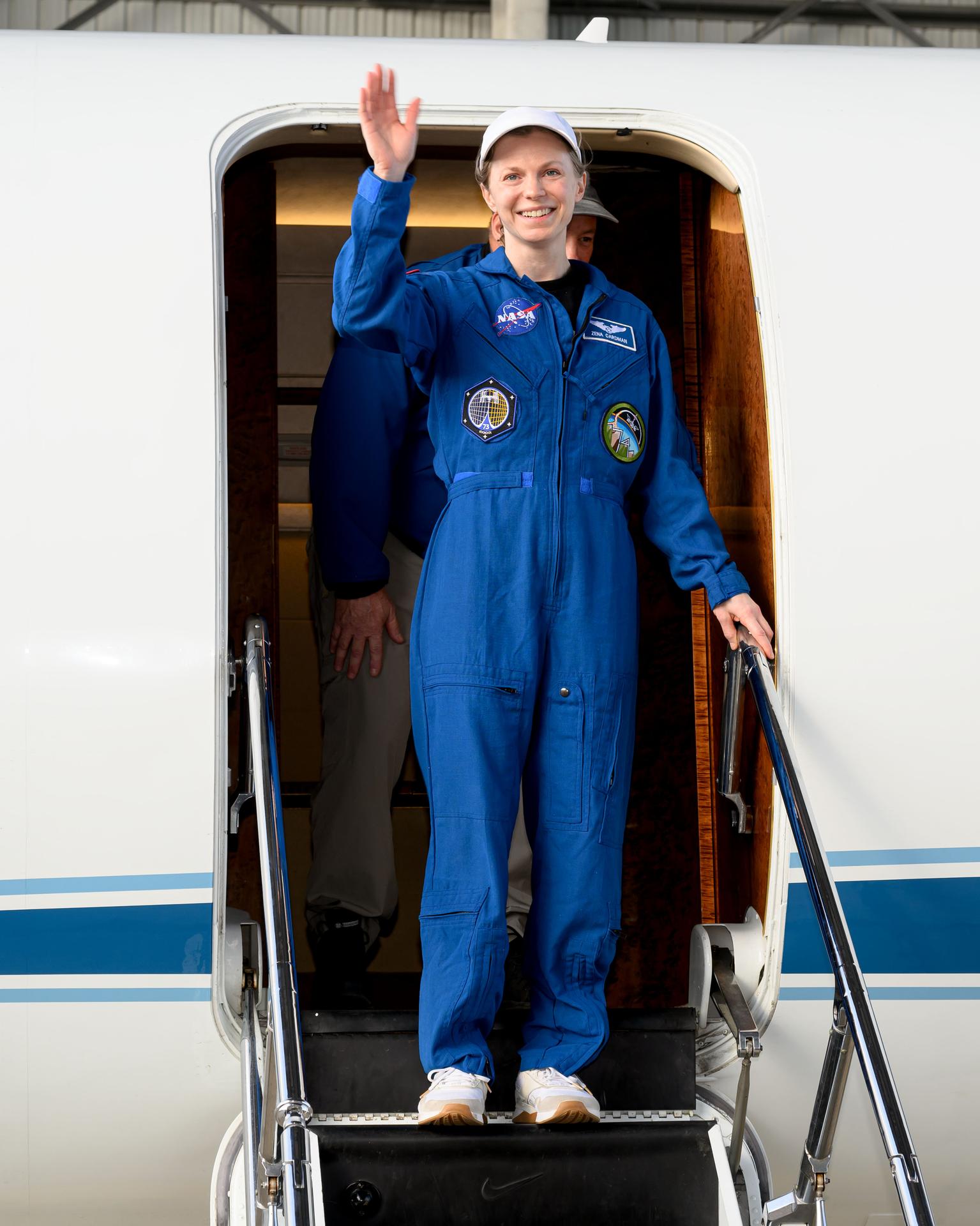
jsc2026e002117 (Jan. 16, 2025) --- NASA astronaut and SpaceX Crew-11 Commander Zena Cardman waves to officials at Ellington Field in Houston, Texas. She departed the International Space Station and returned to Earth the day before aboard the Dragon spacecraft for a parachute-assisted splashdown off the coast of San Diego, California. Credit: NASA/Robert Markowitz
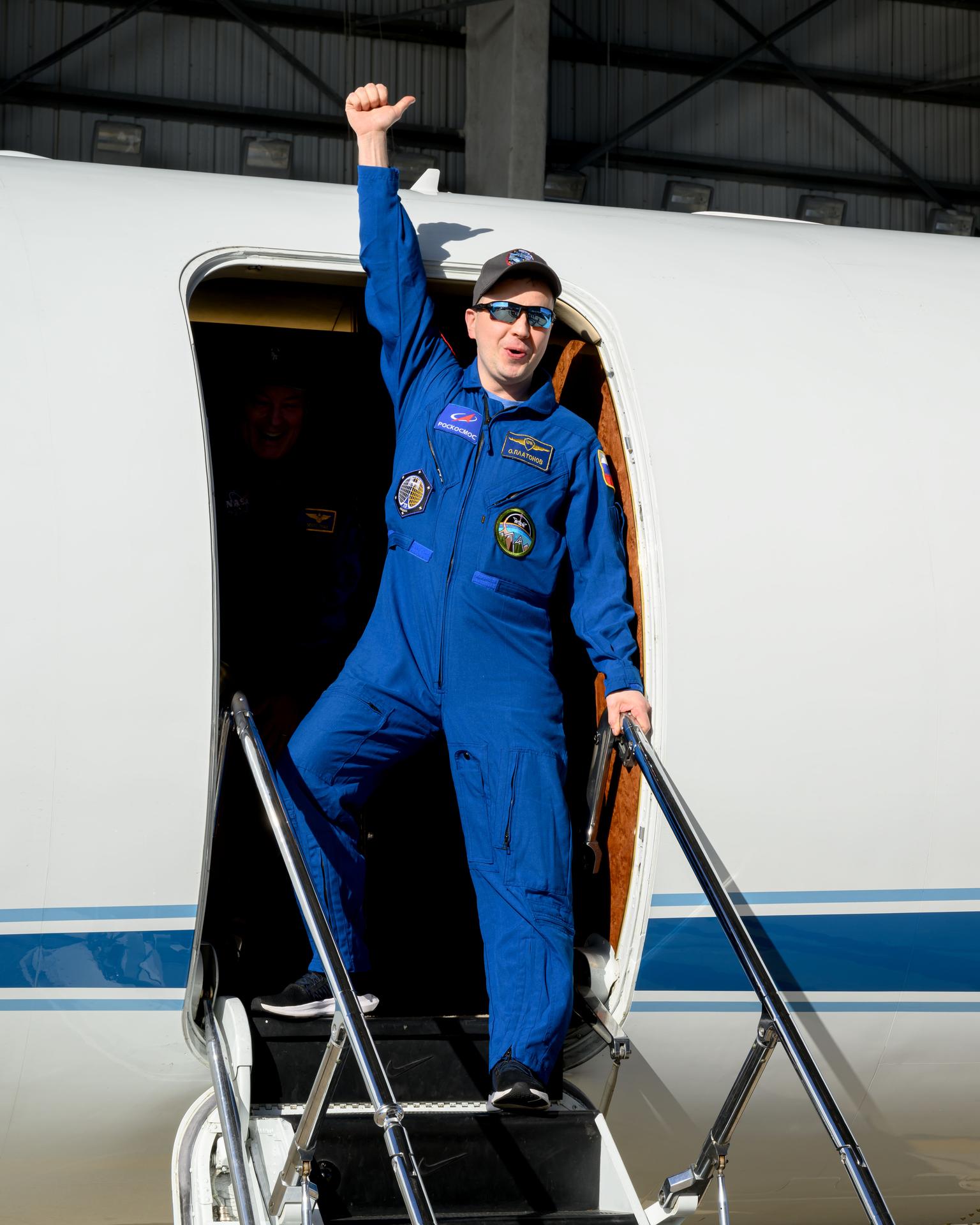
jsc2026e002114 (Jan. 16, 2025) --- Roscosmos cosmonaut and SpaceX Crew-11 Mission Specialist Oleg Platonov waves to officials at Ellington Field in Houston, Texas. He departed the International Space Station and returned to Earth the day before aboard the Dragon spacecraft for a parachute-assisted splashdown off the coast of San Diego, California. Credit: NASA/Robert Markowitz
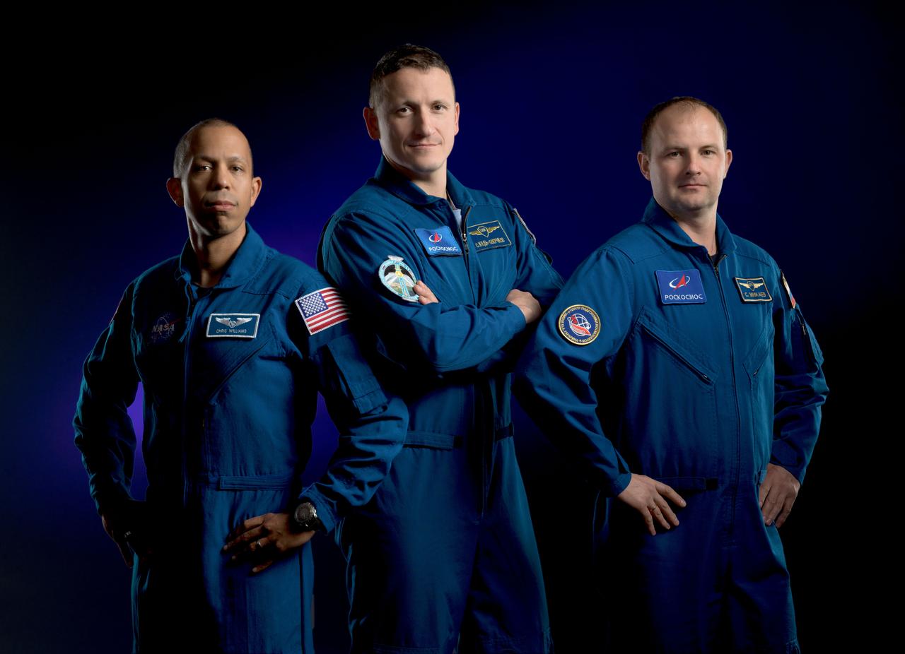
jsc2024e077037_alt (Aug. 7, 2025) --- Expedition 74 crew members (from left) NASA astronaut Chris Williams and Roscosmos cosmonauts Sergey Kud-Sverchkov and Sergey Mikaev pose for a portrait at NASA's Johnson Space Center in Houston, Texas. Credit: NASA/James Blair
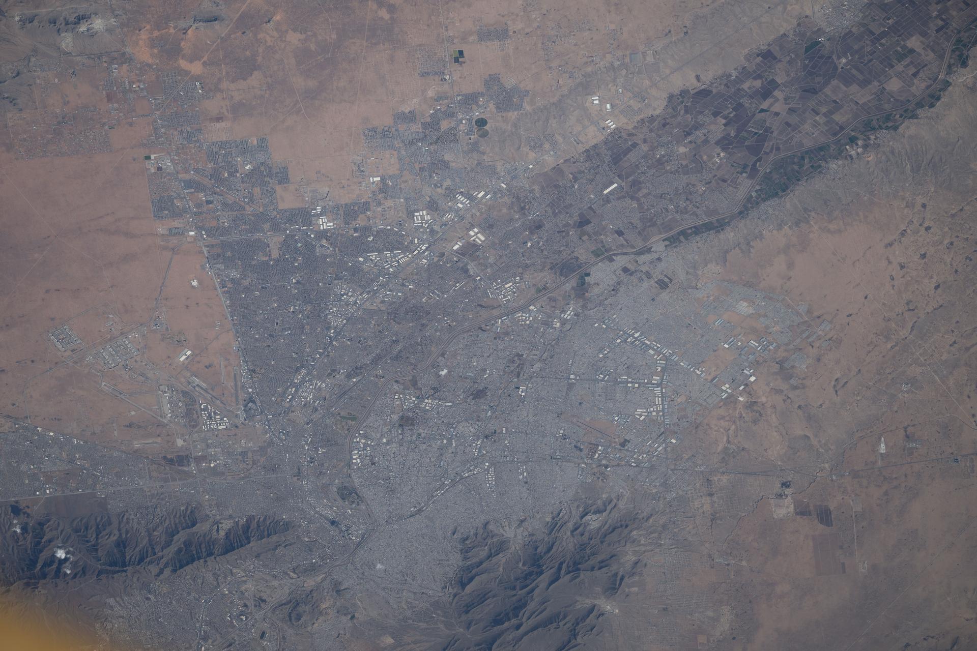
iss074e0312804 (Feb. 10, 2026) --- El Paso, Texas, and Ciudad Juárez, Chihuahua, Mexico, are home to a combined population of over 2.4 million people. The Rio Grande River marks the boundary between the two nations. The International Space Station was orbiting 260 miles above North America when this photograph was taken. Credit: NASA/Chris Williams
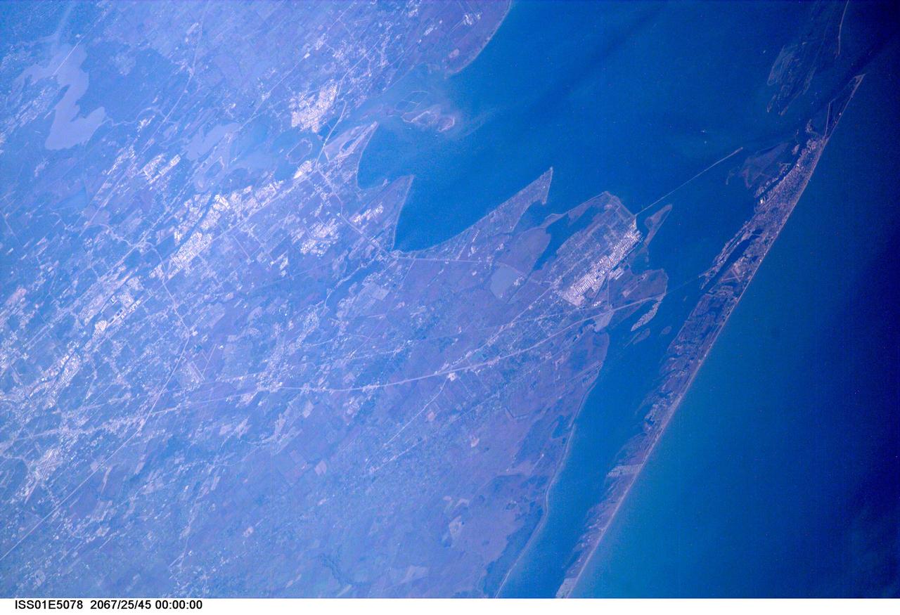
ISS01-E-5078 (December 2000) --- A northwesterly-looking view from over the Gulf of Mexico reveals much of Galveston and Harris Counties, as photographed with a digital still camera from the Earth-orbiting International Space Station (ISS). Galveston Island and Galveston Bay take up most of the right side of the frame, with parts of southern Harris County and even part of north Harris County, including Lake Houston, are visible on the left side of the frame. The Texas City Dike is in the upper right quadrant of the image.

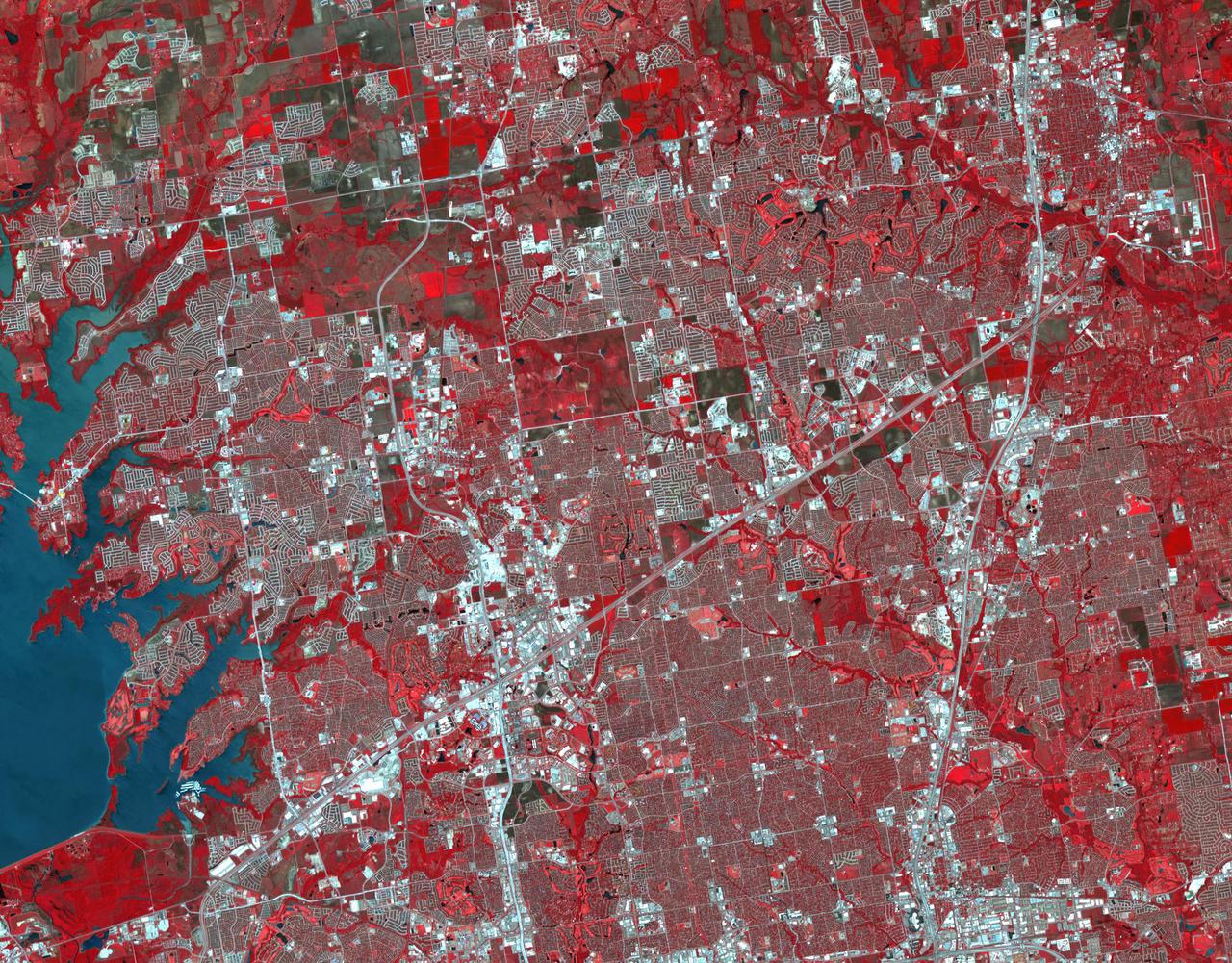
iss073e0379932 (July 15, 2025) --- Houston, Texas, the Lone Star State's largest city with a metropolitan population of about 7.12 million, is pictured at approximately 2:52 a.m. local time from the International Space Station as it orbited 260 miles above. Houston is ringed by three main beltways including the innermost I-610, followed by the Sam Houston Tollway, and the outermost Grand Parkway which will be the longest beltway in the U.S. upon completion.
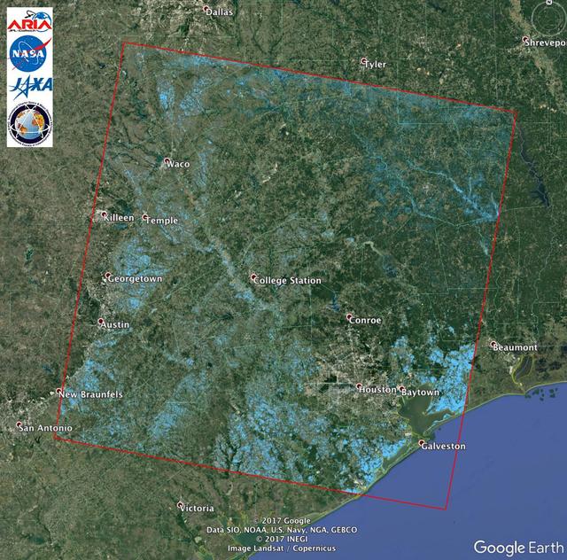
The Advanced Rapid Imaging and Analysis (ARIA) team at NASA's Jet Propulsion Laboratory in Pasadena, California, created this Flood Proxy Map depicting areas of Southeastern Texas that are likely flooded as a result of Hurricane Harvey, shown by light blue pixels. The map is derived from synthetic aperture radar amplitude images from the Japan Aerospace Exploration Agency's (JAXA) ALOS-2 PALSAR-2 satellite, taken before (July 30, 2017) and after (August 27, 2017) Hurricane Harvey made landfall. The map covers an area of 135 square miles (350 square kilometers). Each pixel measures about 538 square feet (50 square meters). Local ground observations provided anecdotal preliminary validation. This flood proxy map should be used as guidance to identify areas that are likely flooded, and may be less reliable over urban areas. ALOS-2 data were accessed through the International Charter. https://photojournal.jpl.nasa.gov/catalog/PIA21928
Local educators participate in heliophysics activities during a teacher professional development event hosted by the NASA Heliophysics Education Activation Team (HEAT) at the Dallas Arboretum, Saturday, April 6, 2024, in Dallas, Texas. Photo Credit: (NASA/Keegan Barber)

Local educators participate in heliophysics activities during a teacher professional development event hosted by the NASA Heliophysics Education Activation Team (HEAT) at the Dallas Arboretum, Saturday, April 6, 2024, in Dallas, Texas. Photo Credit: (NASA/Keegan Barber)
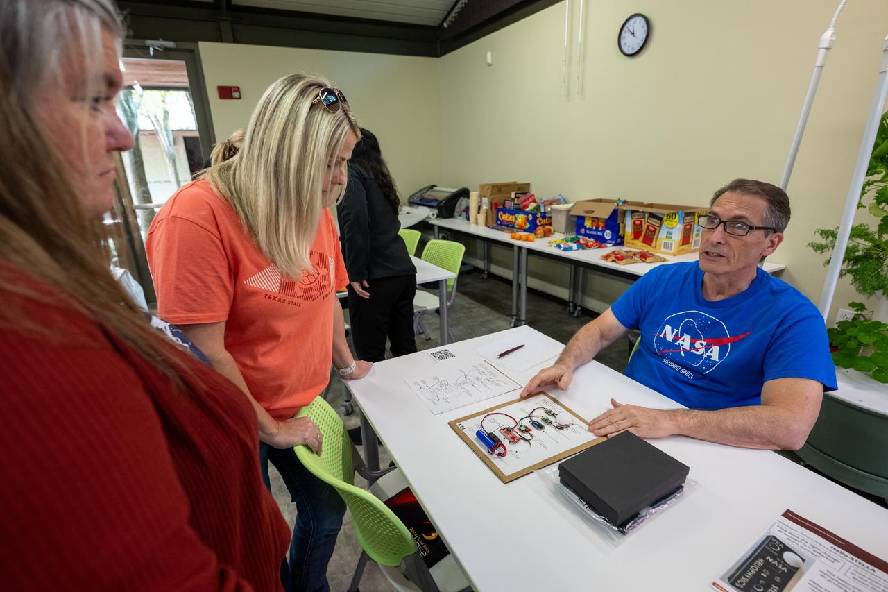
NASA Heliophysics Science Division Instrument Systems Engineer Patrick Haas, right, demonstrates heliophysics activities during a teacher professional development event hosted by the NASA Heliophysics Education Activation Team (HEAT) at the Dallas Arboretum, Saturday, April 6, 2024, in Dallas, Texas. Photo Credit: (NASA/Keegan Barber)
NASA Administrator Jared Isaacman, left, listens to Russell Ralston, senior vice president and general manager of extravehicular activity at Axiom Space, right, during a tour of the company’s extravehicular activity and spacesuit facility, Friday, Jan. 23, 2026, in Houston, Texas. Photo Credit: (NASA/John Kraus)

Local educators participate in heliophysics activities during a teacher professional development event hosted by the NASA Heliophysics Education Activation Team (HEAT) at the Dallas Arboretum, Saturday, April 6, 2024, in Dallas, Texas. Photo Credit: (NASA/Keegan Barber)

Local educators participate in heliophysics activities during a teacher professional development event hosted by the NASA Heliophysics Education Activation Team (HEAT) at the Dallas Arboretum, Saturday, April 6, 2024, in Dallas, Texas. Photo Credit: (NASA/Keegan Barber)

NASA Heliophysics Science Division Instrument Systems Engineer Patrick Haas, left, demonstrates heliophysics activities during a teacher professional development event hosted by the NASA Heliophysics Education Activation Team (HEAT) at the Dallas Arboretum, Saturday, April 6, 2024, in Dallas, Texas. Photo Credit: (NASA/Keegan Barber)
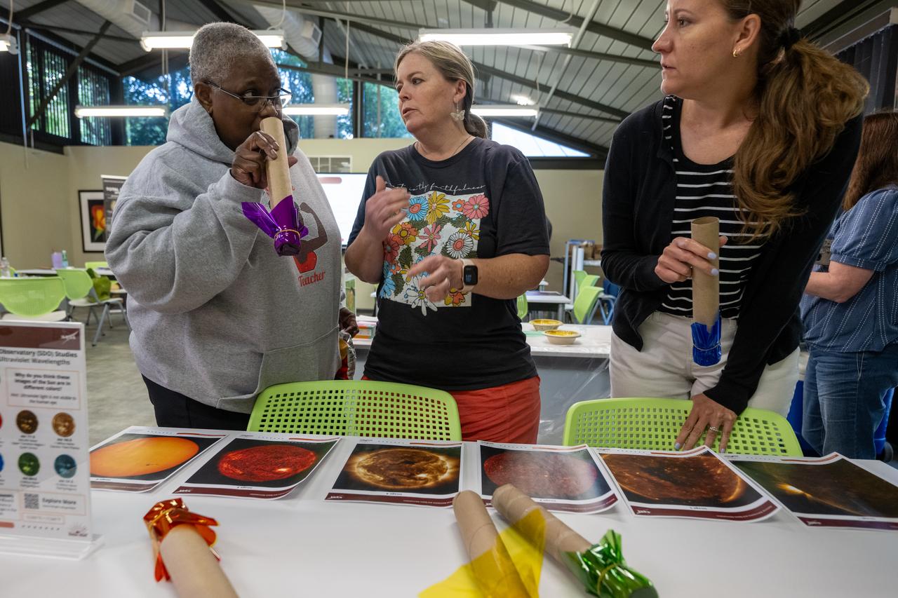
Local educators participate in heliophysics activities during a teacher professional development event hosted by the NASA Heliophysics Education Activation Team (HEAT) at the Dallas Arboretum, Saturday, April 6, 2024, in Dallas, Texas. Photo Credit: (NASA/Keegan Barber)

Local area school children are seen during a NASA event announcing the astronauts assigned to crew the first flight tests and missions of the Boeing CST-100 Starliner and SpaceX Crew Dragon, Friday, Aug. 3, 2018 at NASA’s Johnson Space Center in Houston, Texas. Photo Credit: (NASA/Bill Ingalls)

JOHNSON SPACE CENTER, HOUSTON, TEXAS -- (JSC2000-03028) Official portrait of astronaut Michael E. Lopez-Alegria, mission specialist.

JOHNSON SPACE CENTER, HOUSTON, TEXAS -- (S95-057778) Official portrait of astronaut Pamela A. Melroy, pilot.

JOHNSON SPACE CENTER, HOUSTON, TEXAS -- (JSC2000-03056) Official portrait of astronaut David A. Wolf, mission specialist.

JOHNSON SPACE CENTER, HOUSTON, TEXAS -- (S95-057778) Official portrait of astronaut Pamela A. Melroy, pilot.
JOHNSON SPACE CENTER, HOUSTON, TEXAS -- (JSC2000-03028) Official portrait of astronaut Michael E. Lopez-Alegria, mission specialist.
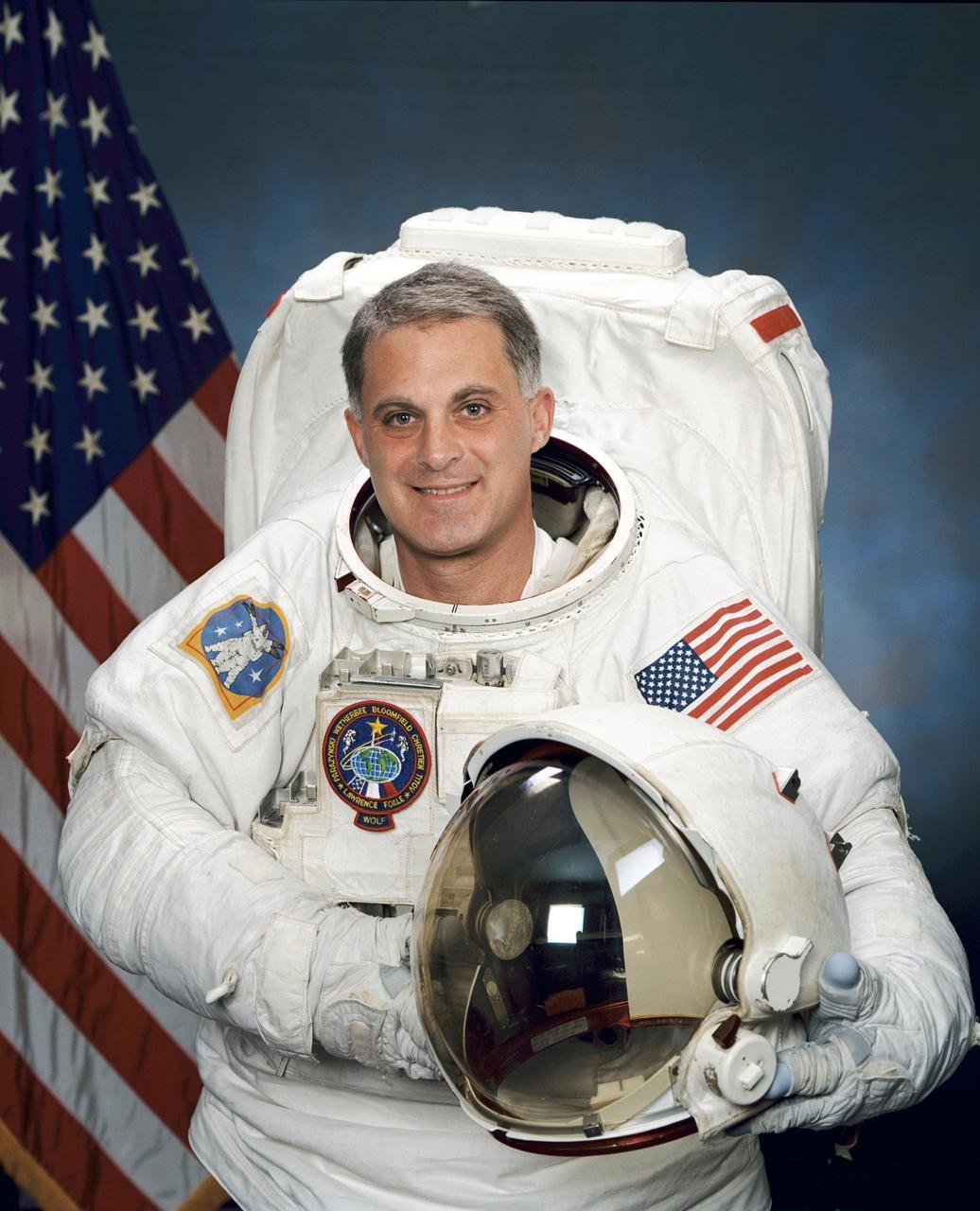
JOHNSON SPACE CENTER, HOUSTON, TEXAS -- (JSC2000-03056) Official portrait of astronaut David A. Wolf, mission specialist.

NASA astronaut candidate Raja Chari poses for a portrait, Friday, July 12, 2019 at Ellington Field in Houston, Texas. Photo Credit: (NASA/Bill Ingalls)