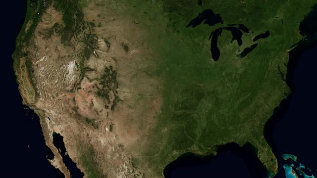
The Mississippi Watershed is the largest drainage basin in North America at 3.2 million square kilometers in area. The USGS has created a database of this area which indicates the direction of waterflow at each point. By assembling these directions into streamflows, it is possible to trace the path of water from every point of the area to the mouth of the Mississippi in the Gulf of Mexico. This animation starts with the points furthest from the Gulf and reveals the streams and rivers as a steady progression towards the mouth of the Mississippi until all the major rivers are revealed. The speed of the reveal of the rivers is not dependent on the actual speed of the water flow. The reveal proceeds at a constant velocity along each river path, timed so that all reveals reach the mouth of the Mississippi at the same time. This animation does not show actual flow rates of the rivers. All rivers are shown with identical rates. The river colors and widths correspond to the relative lengths of river segments. Credit: NASA's Scientific Visualization Studio/Horace Mitchell Go here to download this video: <a href="http://svs.gsfc.nasa.gov/4493" rel="nofollow">svs.gsfc.nasa.gov/4493</a>
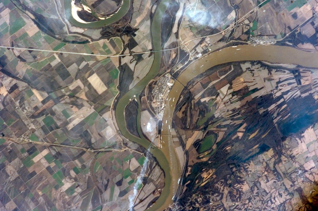
ISS012-E-15035 (12 Jan. 2006) --- The confluence of the Ohio and Mississippi Rivers at Cairo, Illinois is featured in this image photographed by an Expedition 12 crew member on the International Space Station. The Ohio River becomes a tributary of the Mississippi River directly to the south of Cairo, Illinois, a small city on the spit of land where the rivers converge (at center of image). Brown sediment-laden water flowing generally northeast to south from the Ohio River is distinct from the green and relatively sediment-poor water (northwest- to south-flowing) of the Mississippi River. The coloration of the rivers in this image is reversed from the usual condition of a green Ohio and a brown Mississippi. According to scientists, this suggests that recent precipitation in the Ohio River watershed, with very high rainfall over the Appalachians and the northeastern United States in December 2005, has led to a greater sediment load in the Ohio waters. The distinct boundary between the two river’s waters indicates that little to no mixing occurs even 3-4 miles (5-6 kilometers) downstream. The city of Cairo became a prosperous port following the Civil War due to increased riverboat and railroad commerce. Small features on the Ohio are river barges and indicate the continued importance of Cairo as a transport hub. Flooding of the Ohio and Mississippi Rivers presents a continual danger to the city; this danger is lessened by the Birds Point-New Madrid Floodway that begins directly to the south of the river confluence. The floodway lowers flood stages upstream (such as at Cairo) and adjacent to the floodway during major flood events. Part of the extensive levee system associated with flood control of the Mississippi River is visible in the image. Barlow Bottoms (image right), located in adjacent Kentucky, are a wetlands bird watching location that is replenished by periodic floods and releases of Ohio River water.
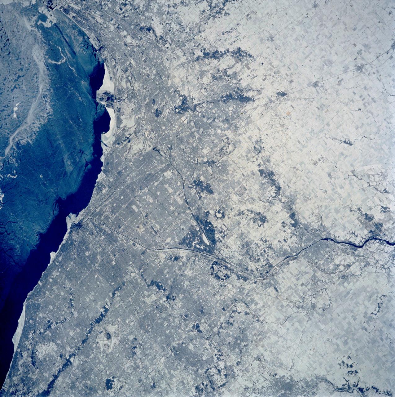
STS060-103-089 (3-11 Feb. 1994) --- The Chicago, Illinois area is in this northeast looking low oblique view obtained in February, 1994. Lake Michigan, a good portion covered with ice due to the very cold winter weather that has plagued this region since early December, 1993, can be seen to the east of the city. The Des Plaines river is visible traversing northeast to southwest through the center of the city. O'Hare International Airport and the Glenview Naval Air Station can be seen to the north of the Des Plaines River. Midway Airport is visible just to the south of the river. Chicago is a port of entry; a major Great Lakes port located at the junction of the St. Lawrence Seaway with the Mississippi River system; the busiest air center in the United States; and an important rail and highway transportation hub. Chicago is known for large grain mills and elevators, iron and steel works, steel fabrication plants, stockyards, meat-packing establishments, and printing and publishing houses. In the early days of settlement, the narrow watershed between Lake Michigan and the Des Plaines River (draining the Mississippi River through the Illinois River), offered an easy portage that led explorers like Father Marquette and Louis Joliet and others to the Great Central Plains. Fort Dearborn, a military post was established in 1803. By 1860, the railroad connected Chicago to the rest of the country and the city became a great mid-continent shipping and receiving center. In 1871, the city built of wood, was almost entirely destroyed by a great fire. After the fire, Chicago was built as a city of steel and stone. During the World's Colombian Exposition held in Chicago in 1893, the city became a leading architectural center. It was here during the Exposition that the skyscraper came into being. Chicago continues to lead the way in this type of architectural structure as is evidenced with the completion of the Sears Tower in 1974.
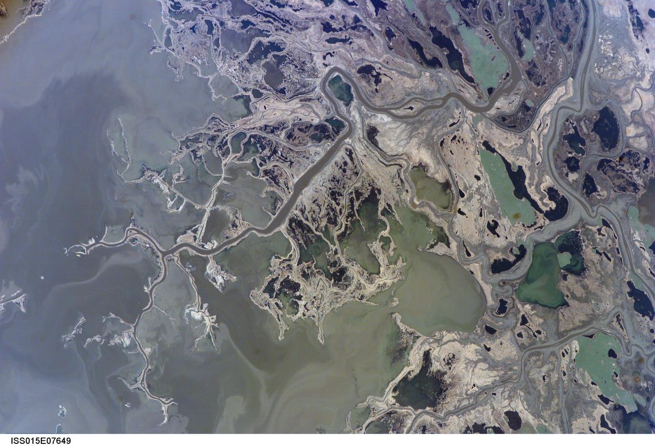
ISS015-E-07649 (11 May 2007) --- Saskatchewan River Delta, Manitoba, Canada is featured in this image photographed by an Expedition 15 crewmember on the International Space Station. This image highlights a portion of the Saskatchewan River delta extending into Cedar Lake in the Province of Manitoba. The Saskatchewan River watershed extends from the Rocky Mountains of Alberta through the plains of Saskatchewan and Manitoba. The construction of the Grand Rapids Dam to the southeast (not shown) in the 1960s flooded the Cedar Lake basin. This has resulted in the formation of numerous shallow, muddy lakes and bogs (dark green to dark grey irregular areas and at upper right) in and around the Saskatchewan River delta. The level of saturation in these bogs is such that peat (semiconsolidated plant and organic matter) deposits have formed; over long periods of time and under the right geological conditions, such deposits can become coal. The velocity of Saskatchewan River water slows significantly as it enters Cedar Lake; as the flow velocity drops, entrained sediment comprised of silt, clay, sand, and gravel is deposited at the river mouth. These deposits, called alluvium by geologists, account for much of the light tan to grey materials bordering the active channels visible in the image (Saskatchewan River, Summerberry River). According to scientists, fossil-bearing amber -- originating from Late Cretaceous (approximately 65-99 million years ago) coal deposits over a thousand kilometers to the west of Cedar Lake -- is also found in the deltaic sediments. As the deposits accumulate, old channels are abandoned and new channels are formed, as the river seeks more favorable flow paths into the lake, this process (known as avulsion) builds out the river delta over time. A typical "birds foot" delta form is currently being constructed at the mouth of the Saskatchewan River (lower left). The birds foot structure is approximately 13 kilometers wide. The Mississippi River's active delta, while having the same general form, is much larger by comparison -- it is approximately 50 kilometers wide.

An oil slick in the Gulf of Mexico following Hurricane Ida – a high-end Category 4 when it made landfall near Port Fourchon, Louisiana, on Aug. 29, 2021 – appears as a green trail in the inset false-color graphic provided by NASA's Delta-X project, while the surrounding seawater appears orange. The National Oceanic and Atmospheric Administration (NOAA) regularly monitors U.S. coastal waters for potential spills and noticed slicks that appeared just off the coast after the hurricane. They were able to use this information from Delta-X to corroborate other data they had about oil slicks in the area (satellite image in the second inset picture). The blue-green swath crossing from the Gulf of Mexico over the Louisiana coast denotes the flight path of the Delta-X radar instrument on Sept. 1, just before 11:30 a.m. CDT. Charged with studying the Mississippi River Delta, Delta-X was gearing up to collect data on Louisiana's coastal wetlands when Hurricane Ida barreled ashore in late August. The storm damaged buildings and infrastructure alike, resulting in power outages, flooding, and oil slicks in the Gulf of Mexico. Oil tends to smooth out the bumps on the ocean's surface, which results in a distinct radar signal that the Delta-X mission was able to pick out of their data. Delta-X added flight paths to their planned schedule – with the support of NASA's Applied Science Disaster Program – in order to collect information over the gulf in areas of interest to NOAA. Delta-X is studying two wetlands – the Atchafalaya and Terrebonne Basins – by land, boat, and air to quantify water and sediment flow as well as vegetation growth. While the Atchafalaya Basin has been gaining land through sediment accumulation, Terrebonne Basin, which is right next to the Atchafalaya, has been rapidly losing land. The data collected by the project will be applied to models used to forecast which areas of the delta are likely to gain or lose land under various sea level rise, river flow, and watershed management scenarios. The mission uses several instruments to collect its data. Affixed to the bottom of a Gulfstream-III airplane, one of those instruments, the all-weather Uninhabited Aerial Vehicle Synthetic Aperture Radar (UAVSAR), bounces radar signals off of Earth's surface, forming a kind of image of a particular area. Repeated images of the same regions, captured at different times, enable researchers to detect changes in those areas, such as fluctuating water levels beneath the vegetation as the tides move in and out of these wetlands. In addition to radar measurements, teams from Caltech, Louisiana State University, Florida International University, and other collaborating institutions gather water and vegetation samples – among other data – by boat, other airborne sensors, and from instruments on the ground. Funded by NASA's Earth Venture Suborbital (EVS-3) program, Delta-X is managed by the agency's Jet Propulsion Laboratory. Caltech in Pasadena, California, manages JPL for NASA. Fall 2021 was Delta-X's last scheduled field campaign, although the five-year mission will run through the end of 2023. https://photojournal.jpl.nasa.gov/catalog/PIA24540