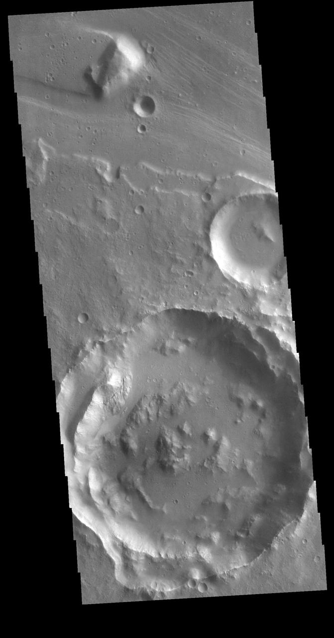
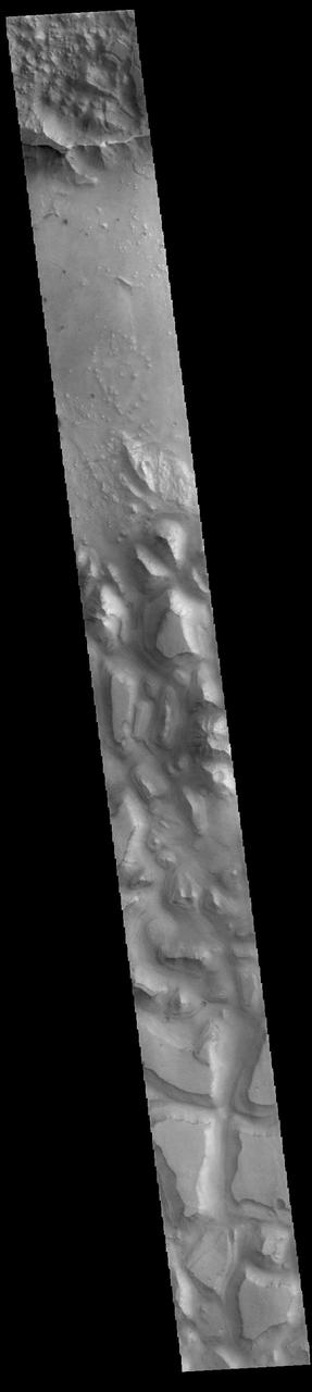
Today's VIS image shows a landslide deposit from the cliffside along Tiu Valles. The mesas at the bottom of the image are part of Hydraotes Chaos. Orbit Number: 64820 Latitude: 2.76947 Longitude: 326.791 Instrument: VIS Captured: 2016-07-25 02:44 http://photojournal.jpl.nasa.gov/catalog/PIA20992
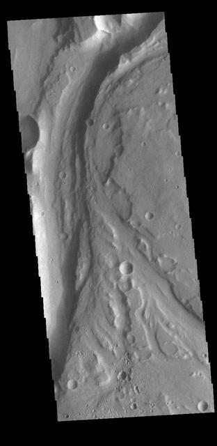
Today's VIS image shows a section of Tiu Valles. Located in Margaritifer Terra, Tiu Valles is a complex channel that is part of a large system of outflow channels that arise from Vallis Marineris and flow northward to empty into Chryse Planitia. Tiu Vallis is 1720 km (1069 miles) long. Orbit Number: 87675 Latitude: 4.06653 Longitude: 329.088 Instrument: VIS Captured: 2021-09-19 11:09 https://photojournal.jpl.nasa.gov/catalog/PIA25261

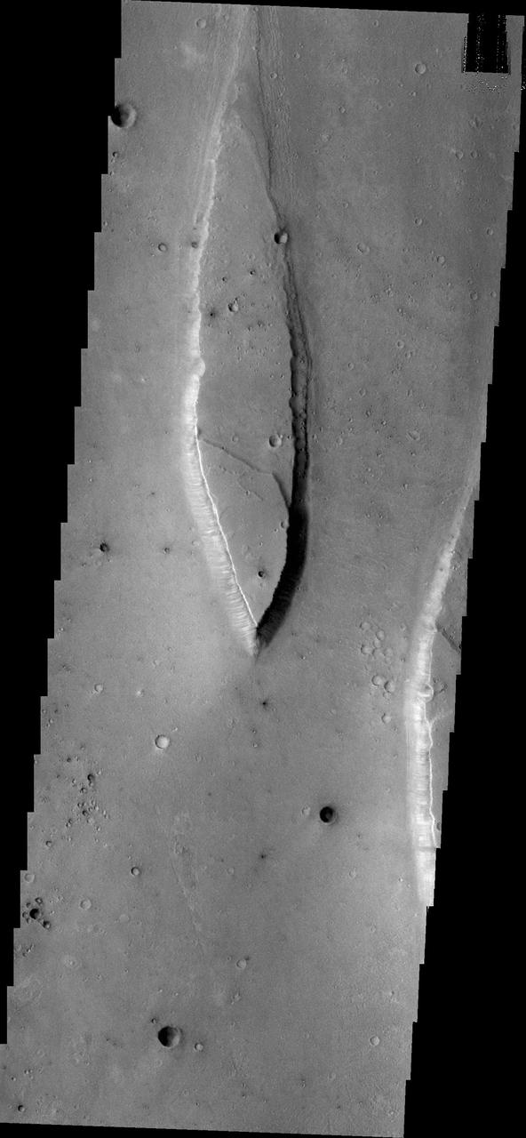
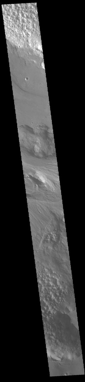
Today's VIS image shows a landslide deposit in Tiu Valles. The impact that created the crater likely caused the landslide, either during the impact event or shortly after. Located in Margaritifer Terra, Tiu Valles is part of a large system of channels that arise from Vallis Marineris and flow northward to empty into Chryse Planitia. Tiu Valles is 1720km long (1069 miles). Orbit Number: 88299 Latitude: 14.6135 Longitude: 325.705 Instrument: VIS Captured: 2021-11-09 20:20 https://photojournal.jpl.nasa.gov/catalog/PIA25197
Tiu Valles is the location of the streamlined island in this image from NASA 2001 Mars Odyssey spacecraft.
The ancient, catastrophic floods on Mars, whose origins remain a mystery, produced a channeled and scoured landscape like this one, which is called Tiu Valles and was imaged by NASA Mars Odyssey spacecraft. http://photojournal.jpl.nasa.gov/catalog/PIA04013
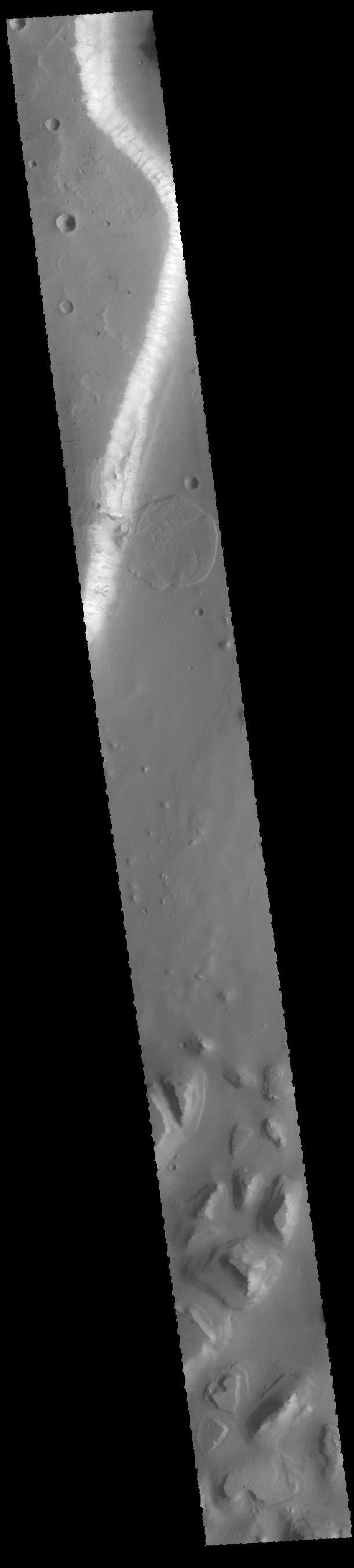
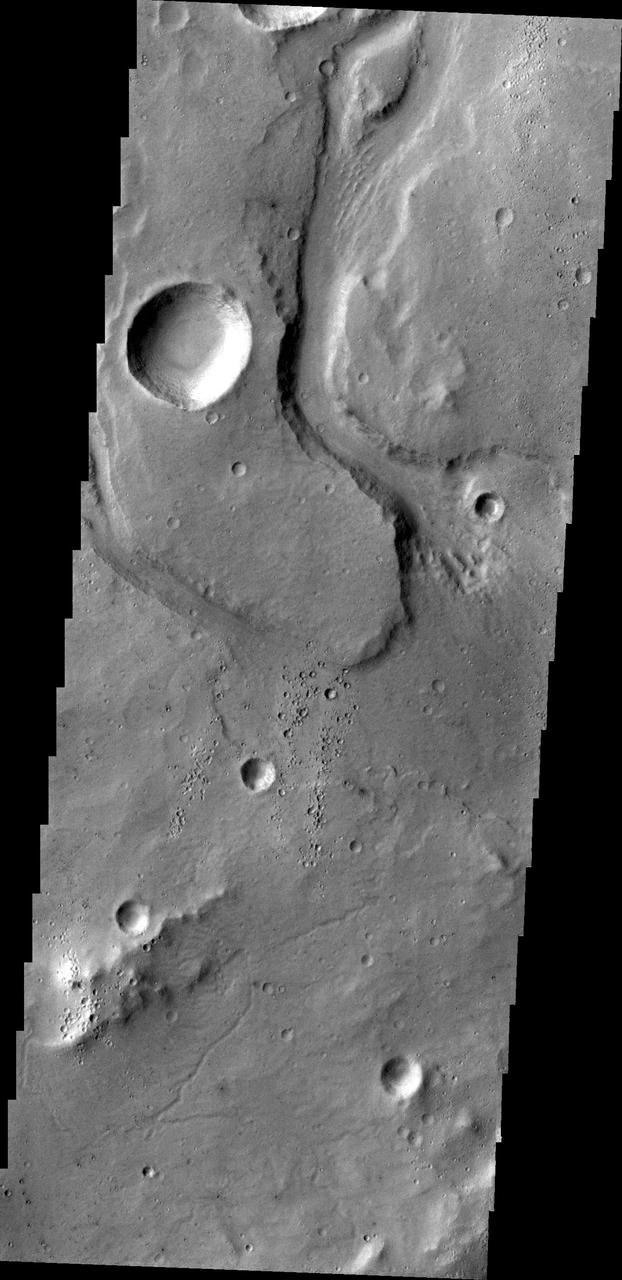
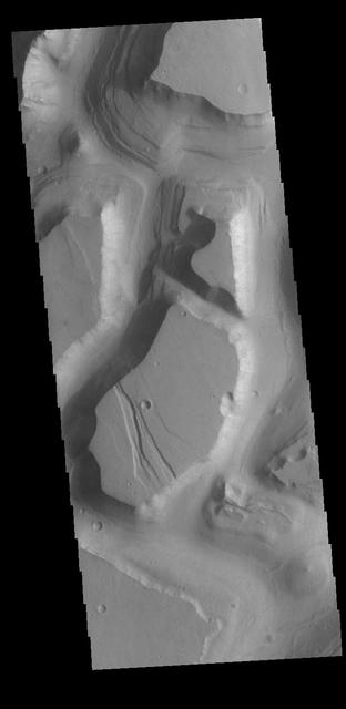
The channel form at the top of this VIS image is part of Tiu Valles. The impact crater has affected the course of the channel, as has the small hill at the top of the image. This type of feature, a hill with a teardrop shaped section, is called a streamline island. The hill interrupts the fluid flow, creating eddies on the downstream side where the flow velocity lessens and it is unable to erode as easily as in the main part of the channel. The teardrop points downstream. Located in Margaritifer Terra, Tiu Valles is part of a large system of channels that arise from Vallis Marineris and flow northward to empty into Chryse Planitia. Orbit Number: 86527 Latitude: 16.6616 Longitude: 325.954 Instrument: VIS Captured: 2021-06-16 22:38 https://photojournal.jpl.nasa.gov/catalog/PIA24998
This image captured by NASA 2001 Mars Odyssey spacecraft shows an unnamed channel on part of the highlands above Tiu Valles.
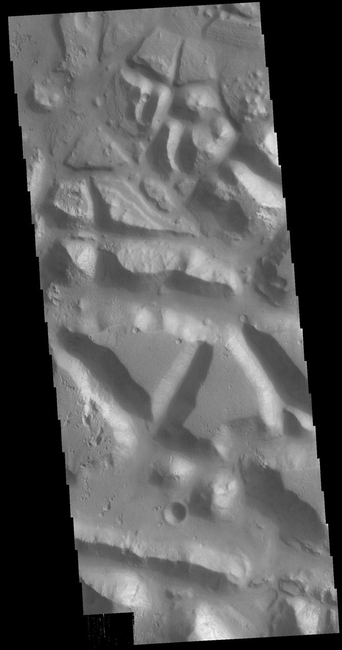
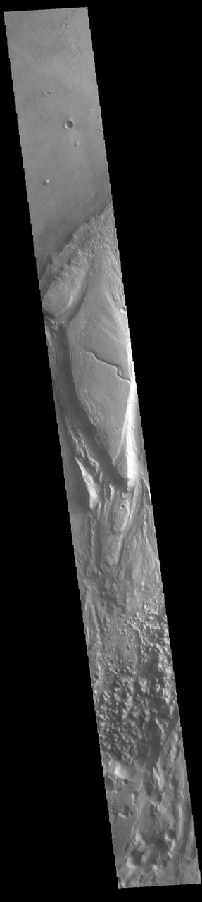
Huge regions of complex valleys and chaos are located in Xanthe and Margaritifer Terras. Rising from Valles Marineris, outflow channels like Ares, Tiu and Shalbantana valles empty into Chryse Planitia. This VIS image shows part of Chryse Chaos, located within Masursky Crater, along the Tiu Valles channel. Chaos forms from erosion of the surface into mesa features. With time the valleys expand creating the jumble of hills seen in the image. Orbit Number: 79152 Latitude: 11.5428 Longitude: 327.544 Instrument: VIS Captured: 2019-10-18 16:42 https://photojournal.jpl.nasa.gov/catalog/PIA23578
Today's VIS image shows a section of unnamed channel located at the margin where large northward flowing channels enter Chryse Planitia. Channels such as Tiu, Ares, and Shalbatana Valles arise from the Valles Marineris canyons to empty a thousand miles later into the Chryse basin. Ares Vallis is over 1600km long (1000 miles) and Tiu Vallis is over 1720km long (1069 miles). Orbit Number: 81548 Latitude: 10.9272 Longitude: 324.621 Instrument: VIS Captured: 2020-05-02 23:34 https://photojournal.jpl.nasa.gov/catalog/PIA23995

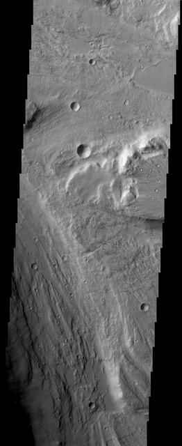
Off the image to the right is Yuty Crater, located between Simud and Tiu Valles. The crater ejcta forms the large lobes along the right side of this VIS image. This type of ejecta was created by surface flow rather than air fall. It is thought that the near surface materials contained volatiles (like water) which mixed with the ejecta at the time of the impact. Orbit Number: 68736 Latitude: 22.247 Longitude: 325.213 Instrument: VIS Captured: 2017-06-12 17:57 https://photojournal.jpl.nasa.gov/catalog/PIA22303
This VIS image shows part of Hydraotes Chaos. Hydraotes Chaos measures about 300 kilometers (190 miles) wide by roughly 350 km (220 mi) north-south. The chaos lies in a valley leading northeast out of Ganges Chasma at the east end of Valles Marineris. Tiu Valles flows northward from Hydraotes Chaos to empty into Chryse Planitia. In planetary nomenclature, the descriptor term chaos means "distinctive area of broken terrain". The general morphology of chaos is steep-sided mesas in close proximity. With time and erosion the valleys widen and the mesas grow smaller. The initial breakup of the land can be due to tectonic forces, but on Mars it is thought that the release of melted, subsurface ice created the terrain. Large channels, like Tiu Valles, usually originate from regions of chaos. Orbit Number: 86003 Latitude: 2.07857 Longitude: 324.563 Instrument: VIS Captured: 2021-05-04 19:05 https://photojournal.jpl.nasa.gov/catalog/PIA24219
This VIS image shows part of Hydraotes Chaos. Hydraotes Chaos measures about 300 kilometers (190 miles) wide by roughly 350 km (220 mi) north-south, and it lies in a valley leading northeast out of Ganges Chasma at the east end of Valles Marineris. Tiu Valles flows northward from Hydraotes Chaos to empty into Chryse Planitia. Orbit Number: 80949 Latitude: 1.53809 Longitude: 326.515 Instrument: VIS Captured: 2020-03-14 15:48 https://photojournal.jpl.nasa.gov/catalog/PIA23906
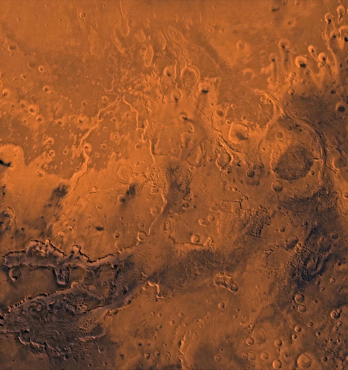
A color image of the south Chryse basin Valles Marineris outflow channels on Mars; north toward top. The scene shows on the southwest corner the chaotic terrain of the east part of Valles Marineris and two of its related canyons: Eos and Capri Chasmata (south to north). Ganges Chasma lies directly north. The chaos in the southern part of the image gives rise to several outflow channels, Shalbatana, Simud, Tiu, and Ares Valles (left to right), that drained north into the Chryse basin. The mouth of Ares Valles is the site of the Mars Pathfinder lander. This image is a composite of NASA's Viking medium-resolution images in black and white and low-resolution images in color. The image extends from latitude 20 degrees S. to 20 degrees N. and from longitude 15 degrees to 53 degrees; Mercator projection. http://photojournal.jpl.nasa.gov/catalog/PIA00418
Today's VIS image shows part of Hydaspis Chaos, one of many regions of chaos in Margaritifer Terra. Chaos terrain is typified by mesas and valleys. The initial breakup of the surface can be due to tectonic forces, although on Mars it is thought that the mode of formation involves release of melted subsurface ice. With time and erosion the valleys widen and the mesas grow smaller. Hydaspis Chaos is is part of the huge outflow system flowing from Valles Marineris to Chryse Planitia. The channel in the center of the image becomes part of the larger Tiu Valles channel. Orbit Number: 87600 Latitude: 3.42796 Longitude: 332.822 Instrument: VIS Captured: 2021-09-13 06:56 https://photojournal.jpl.nasa.gov/catalog/PIA25228
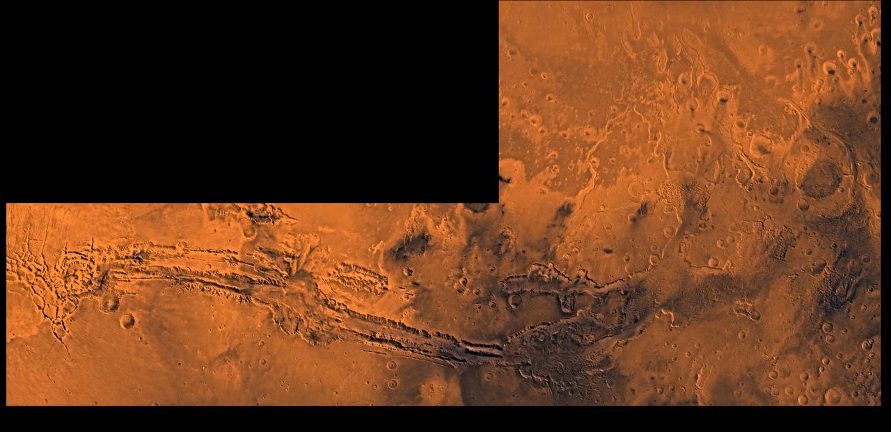
A color image of Valles Marineris, the great canyon and the south Chryse basin-Valles Marineris outflow channels of Mars; north toward top. The scene shows the entire Valles Marineris canyon system, over 3,000 km long and averaging 8 km deep, extending from Noctis Labyrinthus, the arcuate system of graben to the west, to the chaotic terrain to the east and related outflow canyons that drain toward the Chryse basin. Eos and Capri Chasmata (south to north) are two canyons connected to Valles Marineris. Ganges Chasma lies directly north. The chaos in the southeast part of the image gives rise to several outflow channels, Shalbatana, Simud, Tiu, and Ares Valles (left to right), that drained north into the Chryse basin. The mouth of Ares Valles is the site of the Mars Pathfinder lander. This image is a composite of Viking medium-resolution images in black and white and low-resolution images in color; Mercator projection. The image roughly extends from latitude 20 degrees S. to 20 degrees N. and from longitude 15 degrees to 102.5 degrees. The connected chasma or valleys of Valles Marineris may have formed from a combination of erosional collapse and structural activity. Layers of material in the eastern canyons might consist of carbonates deposited in ancient lakes, eolian deposits, or volcanic materials. Huge ancient river channels began from Valles Marineris and from adjacent canyons and ran north. Many of the channels flowed north into Chryse Basin. The south Chryse outflow channels are cut an average of 1 km into the cratered highland terrain. This terrain is about 9 km above datum near Valles Marineris and steadily decreases in elevation to 1 km below datum in the Chryse basin. Shalbatana is relatively narrow (10 km wide) but can reach 3 km in depth. The channel begins at a 2- to 3-km-deep circular depression within a large impact crater, whose floor is partly covered by chaotic material, and ends in Simud Valles. Tiu and Simud Valles consist of a complex of connected channel floors and chaotic terrain and extend as far south as and connect to eastern Valles Marineris. Ares Vallis originates from discontinuous patches of chaotic terrain within large craters. In the Chryse basin the Ares channel forks; one branch continues northwest into central Chryse Planitia and the other extends north into eastern Chryse Planitia. http://photojournal.jpl.nasa.gov/catalog/PIA00426