Triton Dark Plume
Triton Volcanic Plumes

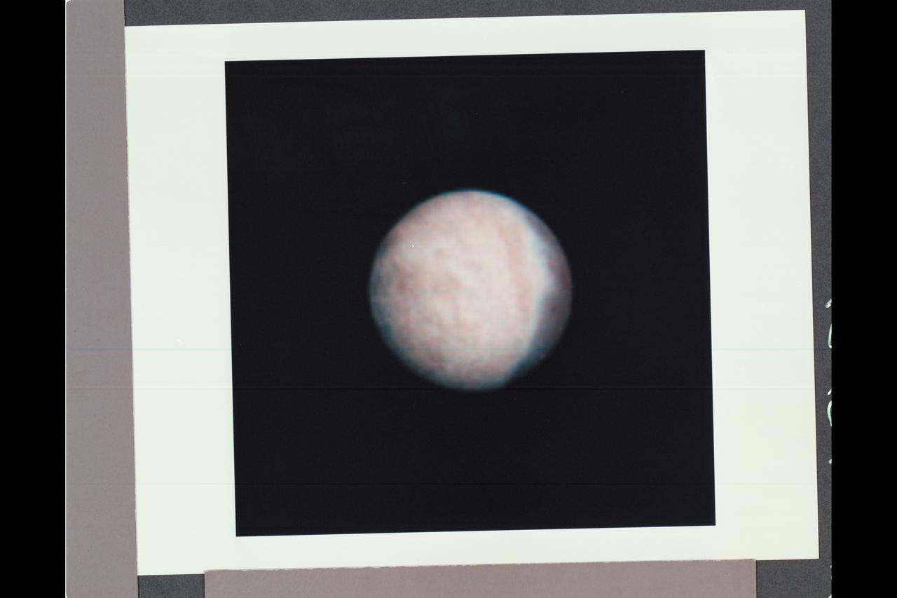
NASA Voyager 2 obtained this color image of Neptune largest satellite,Triton, on Aug. 22, 1989. The south pole of Triton is tipped toward the sun and it is summer in the southern hemisphere.

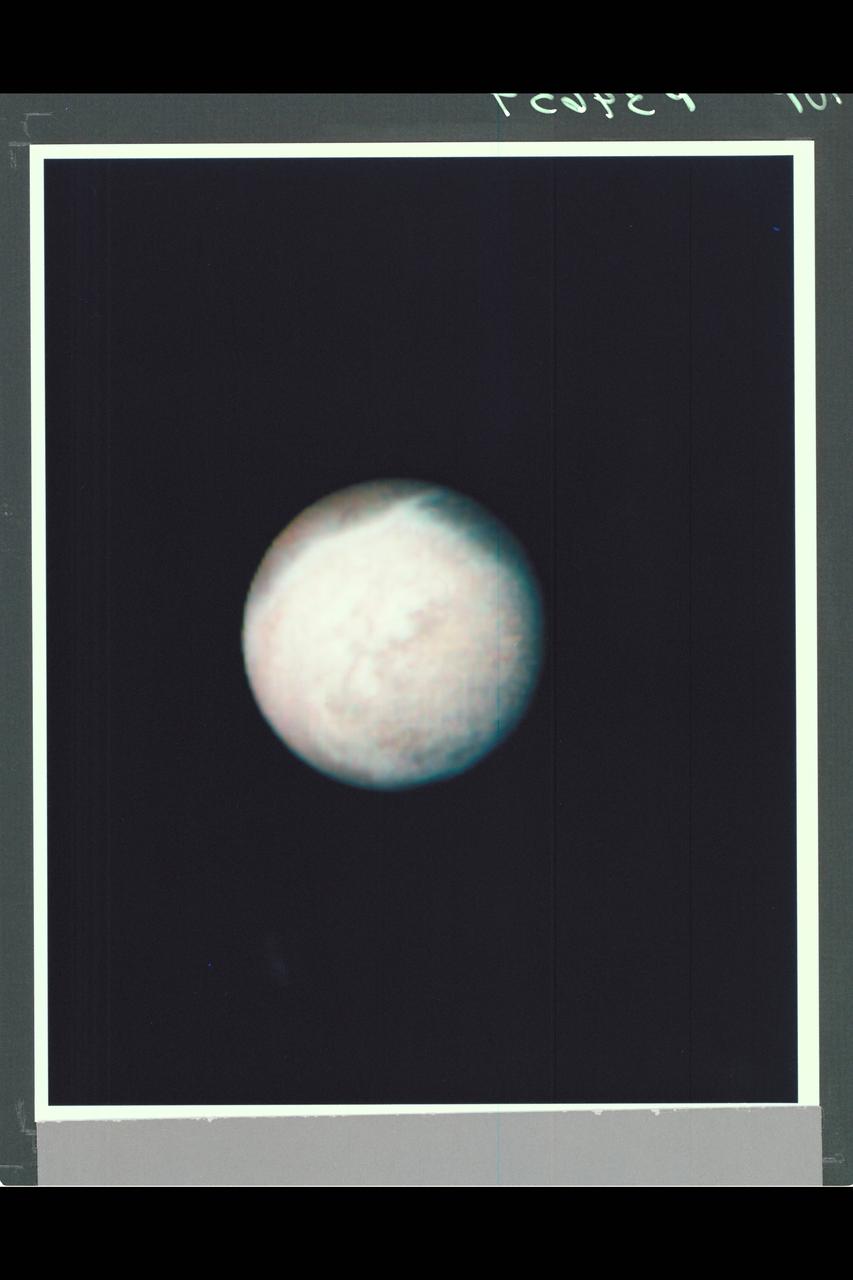
This color photo of Neptune large satellite Triton was obtained on Aug. 24 1989. In reality, there is no part of Triton that would appear blue to the eye. The bright southern hemisphere of Triton, which fills most of this frame, is generally pink.
This false color image of Triton is a composite of images taken through the violet, green and ultraviolet filters. The image was taken early on Aug. 25, 1989 when Voyager 2 was about 190,000 kilometers 118,000 miles from Triton surface.
NASA Voyager 2 took this picture of Neptune largest satellite,Triton, from less than 80,000 km 50,000 miles. The image shows an area in Triton northern hemisphere. The Sun is just above the horizon, so features cast shadows that accentuate height

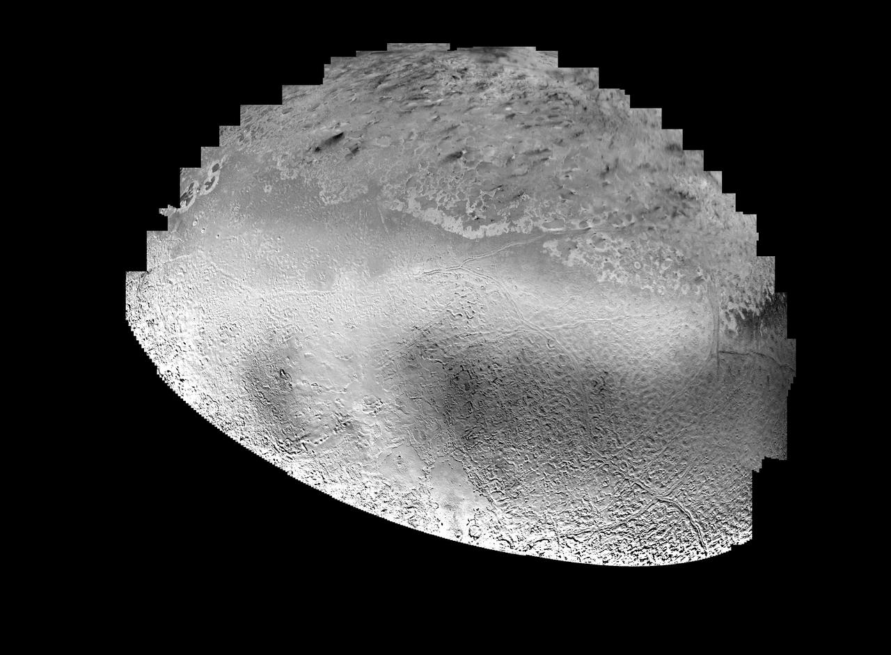
NASA Voyager 2 spacecraft flew by Triton, a moon of Neptune, in the summer of 1989. Dr. Paul Schenk, a scientist at the Lunar and Planetary Institute in Houston, used Voyager data to construct the best-ever global color map of Triton.

Part of the complex geologic history of icy Triton, Neptune largest satellite, is shown in this NASA Voyager 2 photo. The photo was received as part of a Triton-mapping sequence in 1989.

Intriguing patterns of unknown origin appeared on the surface of Neptune largest satellite, Triton, in this image returned by NASA Voyager 2 on Aug. 22, 1989. Voyager images showed that Triton is one of the brightest objects in the solar system,

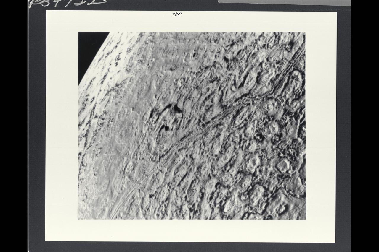
NASA Voyager 2 was 530,000 kilometers 330,000 miles from Neptune largest satellite, Triton, when this photo was taken, Aug. 24, 1989. This is the first photo of Triton to reveal surface topography.

This composite view from NASA Voyager 2 shows Neptune on Triton horizon. The foreground in this computer generated view of Triton maria as they would appear from a point approximately 45 km above the surface. http://photojournal.jpl.nasa.gov/catalog/PIA00344

This image, taken by NASA Voyager 2 early in the morning of Aug. 23, 1989, is a false color image of Triton, Neptune largest satellite; mottling in the bright southern hemisphere is present.
This photo of Triton is one of a continuing series of observatory phase images obtained by NASA Voyager spacecraft. Lines inscribed on the image at right form a reference grid used by the Imaging Science Team.
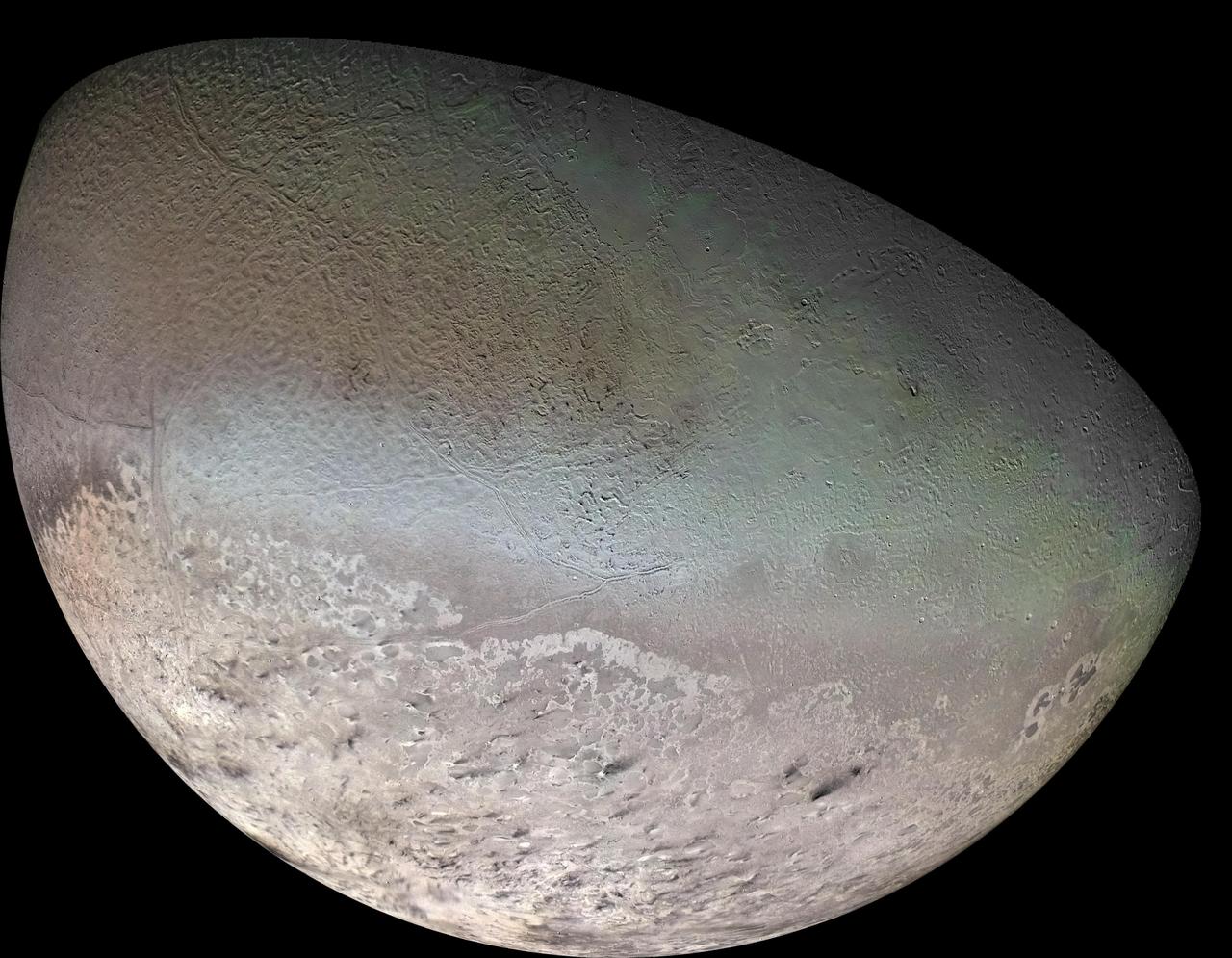
Global color mosaic of Triton, taken in 1989 by Voyager 2 during its flyby of the Neptune system. Color was synthesized by combining high-resolution images taken through orange, violet, and ultraviolet filters; these images were displayed as red, green, and blue images and combined to create this color version. With a radius of 1,350 (839 mi), about 22% smaller than Earth's moon, Triton is by far the largest satellite of Neptune. It is one of only three objects in the Solar System known to have a nitrogen-dominated atmosphere (the others are Earth and Saturn's giant moon, Titan). Triton has the coldest surface known anywhere in the Solar System (38 K, about -391 degrees Fahrenheit); it is so cold that most of Triton's nitrogen is condensed as frost, making it the only satellite in the Solar System known to have a surface made mainly of nitrogen ice. The pinkish deposits constitute a vast south polar cap believed to contain methane ice, which would have reacted under sunlight to form pink or red compounds. The dark streaks overlying these pink ices are believed to be an icy and perhaps carbonaceous dust deposited from huge geyser-like plumes, some of which were found to be active during the Voyager 2 flyby. The bluish-green band visible in this image extends all the way around Triton near the equator; it may consist of relatively fresh nitrogen frost deposits. The greenish areas includes what is called the cantaloupe terrain, whose origin is unknown, and a set of "cryovolcanic" landscapes apparently produced by icy-cold liquids (now frozen) erupted from Triton's interior. http://photojournal.jpl.nasa.gov/catalog/PIA00317

NASA Voyager 2 spacecraft flew by Triton, a moon of Neptune, on August 25, 1989. This frame from a video using Voyager data recreates that exciting encounter.
This picture of Triton is a mosaic of the highest resolution images taken by NASA Voyager 2 on Aug. 25, 1989 from a distance of about 40,000 kilometers 24,800 miles.
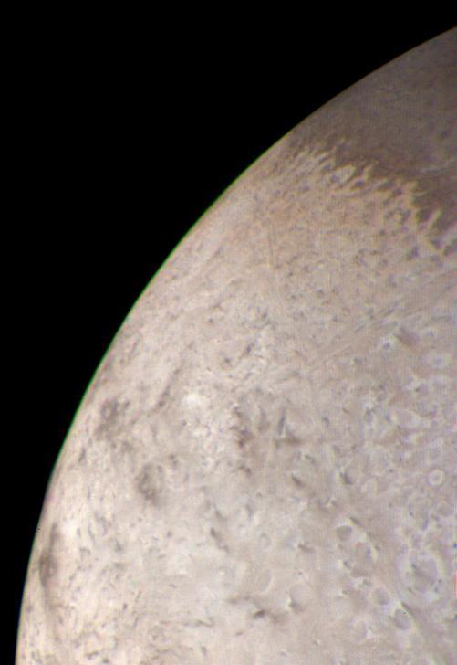
This natural color image of the limb of Triton was taken early in the morning of Aug. 25 1989, when the Voyager 2 spacecraft was at a distance of about 210,000 kilometers 128,000 miles from the icy satellite.
Mosaic of Triton constructed from 16 individual images. After globally minimizing the camera pointing errors, the frames we reprocessed by map projections, photometric function removal and placement in the mosaic.

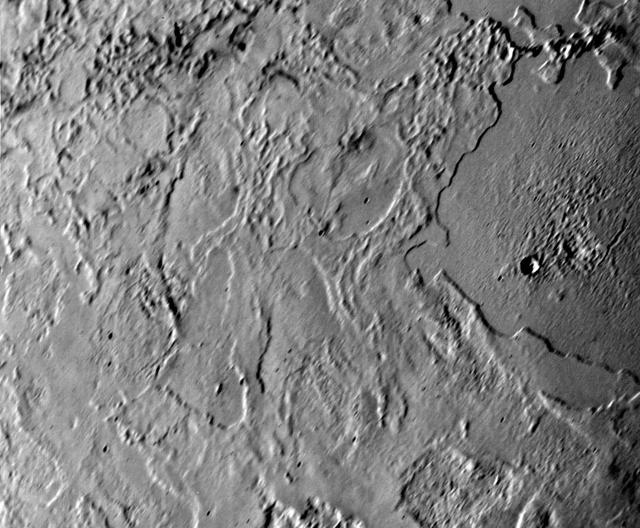
This view of the volcanic plains of Neptune moon Triton was produced using topographic maps derived from images acquired by NASA Voyager spacecraft during its August 1989 flyby, 20 years ago this week.

This view of the volcanic plains of Neptune moon Triton was produced using topographic maps derived from images acquired by NASA Voyager spacecraft during its August 1989 flyby, 20 years ago this week.

NASA Voyager 2 obtained this parting shot of Triton, Neptune largest satellite, shortly after closest approach to the moon and passage through its shadow on the morning of Aug. 25, 1989.

This view of the volcanic plains of Neptune moon Triton was produced using topographic maps derived from images acquired by NASA Voyager spacecraft during its August 1989 flyby, 20 years ago this week.

This simulated voyage over the surface of Neptune large moon Triton was produced using topographic maps derived from images acquired by NASA Voyager spacecraft during its August 1989 flyby, 20 years ago this week.
This image of Triton was taken on Aug. 25 1989 by NASA Voyager 2. The image was received at JPL four hours later at about 4:20 a.m. The smallest detail that can be seen is about 2.5 kilometers 1.5 miles across.

This computer generated montage created from images obtained by NASA Voyager 2 shows Neptune as it would appear from a spacecraft approaching Triton, Neptune largest moon at 2706 km 1683 mi in diameter. http://photojournal.jpl.nasa.gov/catalog/PIA00340

Features as small as 100 km 62 miles across can be seen in this color image of Neptune satellite Triton, photographed by NASA Voyager 2 on Aug. 20, 1989, while it was still 5.4 million km 3.3 million miles from Neptune.

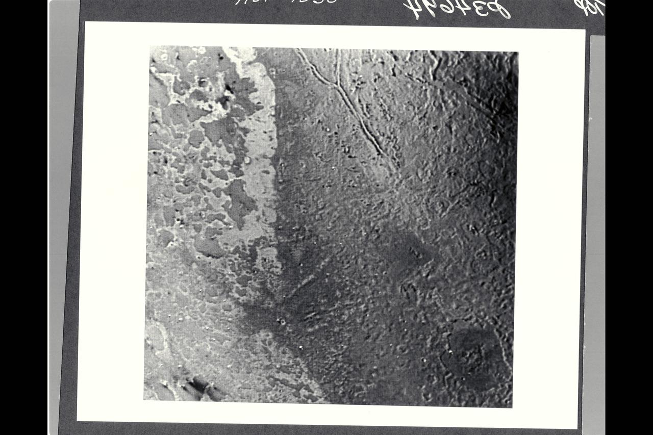
NASA's Voyager 2 acquired this black and white image of Triton, Neptune's largest satellite, during the night of Aug. 24-25, 1989. Triton's limb cuts obliquely across the middle of the image. The field of view is about 1,000 km (600 miles) across. Three irregular dark areas, surrounded by brighter material, dominate the image. Low-lying material with intermediate albedo occupies the central area, and fresh craters occur along the right margin. Sub-parallel alignment of linear patches of dark material shown in the lower and left part of the image suggests that the patches are structurally controlled. http://photojournal.jpl.nasa.gov/catalog/PIA00056
This color image from NASA Voyager 2 was reconstructed by making a computer composite of three black and white images taken through red, green, and blue filters. Details on Triton surface unfold dramatically in this sequence of approach images. http://photojournal.jpl.nasa.gov/catalog/PIA00329
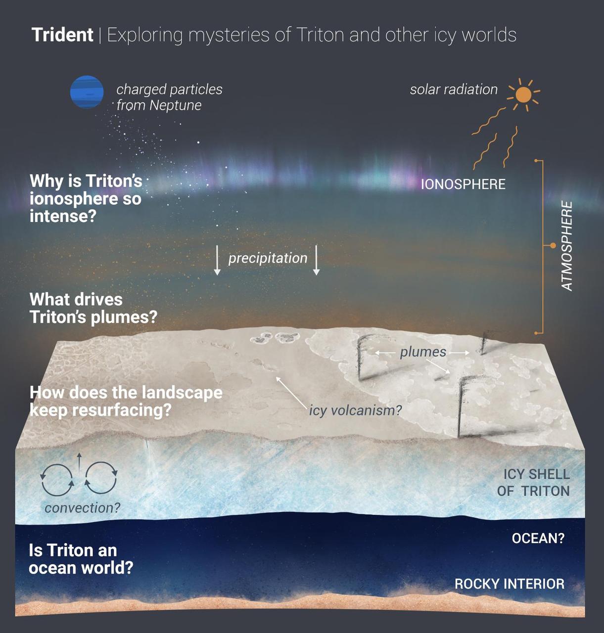
A new mission competing for selection under NASA's Discovery Program would explore Neptune's largest moon, Triton, which is potentially an ocean world with liquid water under its icy crust. Trident aims to answer the questions outlined in the graphic illustration above. The questions fall under Trident's three main goals. The first goal is to explore the factors that lead to a solar system body having the necessary ingredients — including water — to be habitable. A second goal is to explore vast, unseen lands. Most of what we know of the moon came from Voyager 2 data. But we've only seen 40% of the moon's surface; Trident would map most of the remainder. Trident's third major goal: to understand how Triton's surface keeps renewing itself. The surface is remarkably young, geologically speaking (possibly only 10 million years old in a 4.6-billion-year-old solar system) and has almost no visible craters. The Trident team is one of four developing concept studies for new missions. Up to two will be selected by summer 2021 to become a full-fledged mission and will launch later in the decade. https://photojournal.jpl.nasa.gov/catalog/PIA23874

This is one of the most detailed views of the surface of Triton taken by NASA Voyager 2 on its flyby of the large satellite of Neptune early in the morning of Aug. 25, 1989. The picture was stored on the tape recorder and relayed to Earth later. http://photojournal.jpl.nasa.gov/catalog/PIA00061
Voyager violet, green, and ultraviolet images of Triton were map projected into cylindrical coordinates and combined to produce this false color terrain map. Several compositionally distinct terrain and geologic features are portrayed. At center is a gray blue unit referred to as 'cantaloupe' terrain because of its unusual topographic texture. The unit appears to predate other units to the left. Immediately adjacent to the cantaloupe terrain, is a smoother unit, represented by a reddish color, that has been dissected by a prominent fault system. This unit apparently overlies a much higher albedo material, seen farther left. A prominent angular albedo boundary separates relatively undisturbed smooth terrain from irregular patches which have been derived from breakup of the same material. Also visible at the far left are diffuse, elongated streaks, which seem to emanate from circular, often bright centered features. The parallel streaks may represent vented particulate materials blown in the same direction by winds in Triton's thin atmosphere. The Voyager Mission was conducted by JPL for NASA's Office of Space Science and Applications. http://photojournal.jpl.nasa.gov/catalog/PIA00060
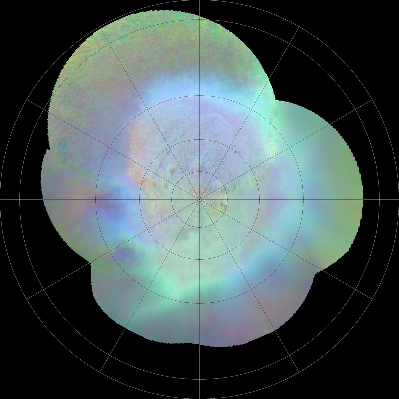
This polar projection from NASA Voyager 2 of Triton southern hemisphere provides a view of the southern polar cap and bright equatorial fringe. The margin of the cap is scalloped and ranges in latitude from +10 degrees to -30 degrees. The bright fringe is closely associated with the cap's margin; from it, diffuse bright rays extend north-northeast for hundreds of kilometers. The bright fringe probably consists of very fresh nitrogen frost or snow, and the rays consist of bright-fringe materials that were redistributed by north-moving Coriolis-deflected winds. http://photojournal.jpl.nasa.gov/catalog/PIA00423

This image from NASA's Voyager 2 of the south polar terrain of Triton, taken on Aug. 25, 1989 reveals about 50 dark plumes or 'wind streaks' on the icy surface. The plumes originate at very dark spots generally a few miles in diameter and some are more than 100 miles long. The spots which clearly mark the source of the dark material may be vents where gas has erupted from beneath the surface and carried dark particles into Triton's nitrogen atmosphere. Southwesterly winds then transported the erupted particles, which formed gradually thinning deposits to the northeast of most vents. It is possible that the eruptions have been driven by seasonal heating of very shallow subsurface deposits of volatiles, and the winds transporting particles similarly may be seasonal winds. The polar terrain, upon which the dark streaks have been deposited, is a region of bright materials mottled with irregular, somewhat dark patches. The pattern of irregular patches suggests that they may correspond to lag deposits of moderately dark material that cap the bright ice over the polar terrain. http://photojournal.jpl.nasa.gov/catalog/PIA00059

This image was returned by NASA Voyager 2 spacecraft on July 3, 1989. The planet and its largest satellite, Triton, are captured in view; Triton appears in the lower right corner at about 5 oclock relative to Neptune.

This dramatic view of the crescents of Neptune and Triton was acquired by Voyager 2 approximately 3 days, 6 and one-half hours after its closest approach to Neptune north is to the right.
This mosaic from NASA Galileo Probe is of an equatorial hotspot on Jupiter and shows the features of a hazy cloud layer tens of kilometers above Jupiter main visible cloud deck.

This image was returned by NASA's Voyager 2 spacecraft on July 3, 1989. The planet and its largest satellite, Triton, are captured in view; Triton appears in the lower right corner at about 5 oclock relative to Neptune. http://photojournal.jpl.nasa.gov/catalog/PIA01287
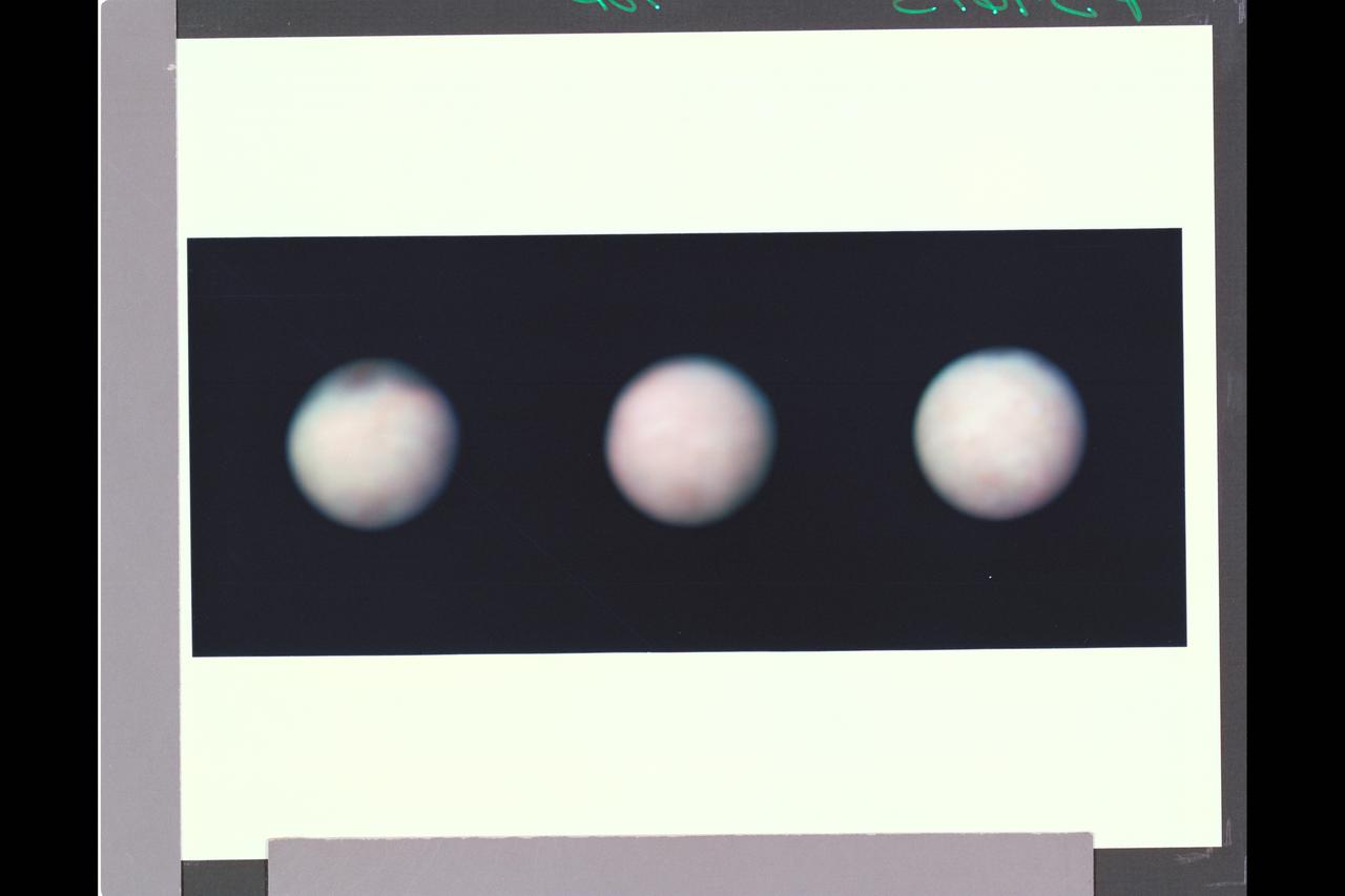
P-34615 These three color images of Triton were taken at three different orbital longitudes to show different faces of the neptune moon. the overall pinkish cast of the images may be due to the presence of reddish material on Triton produced by irradiation of methane gas and ice on Triton. In these pictures the south pole is at roughly 6 o'clock, about 1/6th of the way from the bottom. Near the top of the left on Triton's equator are several large dark spots that are probably suface markings. These markings rotate with a 5.88-day orbital period of Triton. The left image has a central longitude 288 degrees, the center at 351 degrees ( nearly the hemisphere that will be seen at Voyager's closest approach to Triton), and the right image is at 35 degrees logitude.
P-34665 This false color Voyager 2 image of Neptune's satellite Triton, is a composite of three images taken through ultraviolet, green, and viloet filters. The smallest resolvable features are about 47 km., or 29 miles accross. Mottling in the bright southern hemisphere may be the result of topography, if Triton's crust is predominently water ice, which is rigid at Triton's surface temperature. Alternatively, the mottling could be due to markings on a smooth surface, if the crust is composed of nitrogen, carbon monoxide, or methane ice, since they are soft at the same temperature.
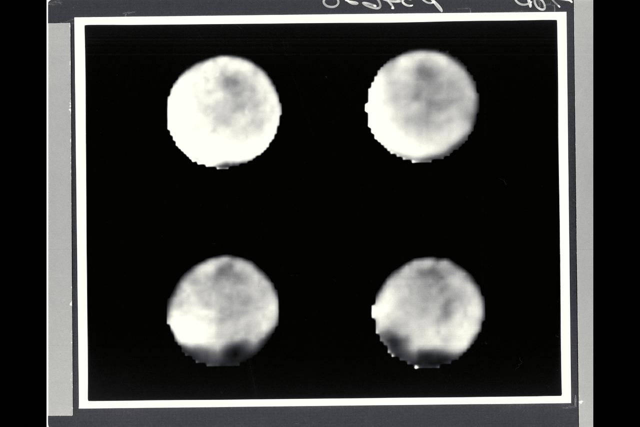
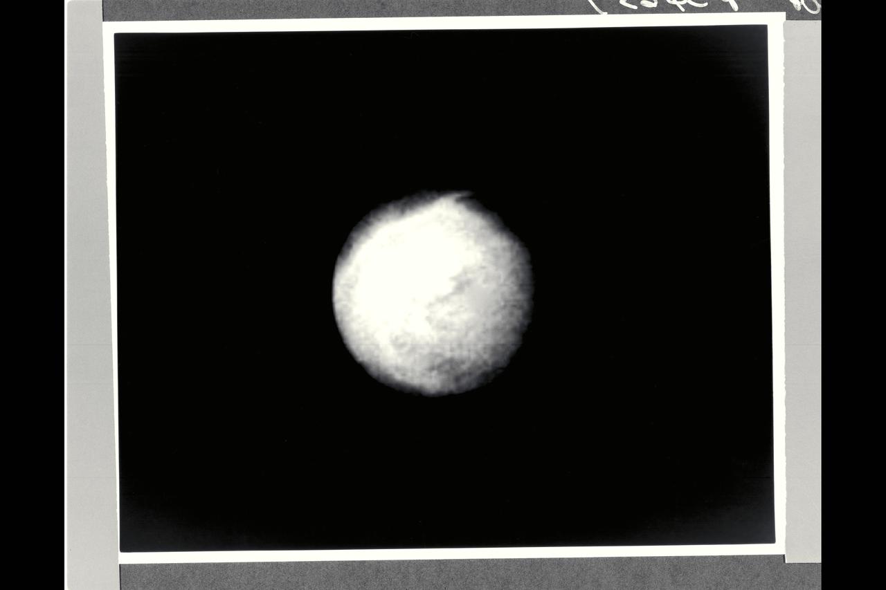
August 17 to 19, 1989 Range : 11.5 million km (7.1 million mi.) to 7.9 million km (4.9 million mi.) Four black and white images of Neptune's largest satellite, Triton, show it's rotation between the first (upper left) image and the last (lower right). Resolution improves from about 200 km (124 miles) to 150 km (93 miles) per line pair. Triton's south pole lies in the dark area near the bottom of the disk. Dark spots, roughly 1,000 km (620 miles) across, occur near the equator, and show Triton rotation between images. The rotation appears to be synchronous with Triton's 5.88-day orbital period (i.e., Triton rotates on its axis in the same time it revolves around Neptune.) The spots' constant rotation rate and their visibility near the edge of the disk suggest the spots are surface features. Whatever atmosphere is present on Triton appears transparent enough that Voyager 2's cameras can see through it.
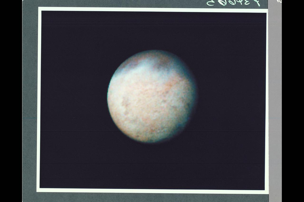
Range : 530,000 km (330,000 mi.) This color photo of Neptune's large satellite Triton has a resolution of about 10 km (6.2 mi), sufficient to begin to show topographic detail. The image was made from pictures taken through the green, violet and ultraviolet filters. In this technique, regions that are highly reflective in the ultraviolet appear blue in color. In reality, there is no part of Triton that would appear blue to the eye. The bright southern hemisphere of Triton, which fills most of this frame, is generally pink in tone as is the even brighter equatorial band. The darker regions north of the equator also tend to be pink or reddish in color.
P-34690 Field of View : 1,000 km. or 600 miles This photograph of Neptune's moon Triton was acquired by Voyager 2. Triton's limb cuts obliquely accross the middle of the image. Three irregular dark areas, surrounded by brighter material, dominate the image. Low-lying material with intermediate albedo occupies the central area, anf fresh craters occur along the right margin. sub-parallel alignment of linear patches of dark material shown in the lower and left part of the image suggests that the patches are structurally controlled.
Range : 5.4 million km (3.3 million miles) Features as small as 100 km (62 miles) across can be seen in this color image of Neptune's satellite Triton, photographed by Voyager 2. Triton's overall pinkish color may be due to reddish materials produced by irradiation of methane gas and ice on the satellite. The dark areas near the top of the image seem to be part of a belt of dark markings observed near Trition's equator at different longitudes. Generally, darker areas on Triton appear to be somewhat redder in color than brighter areas. The central longitude in the image is 123 degrees. Here the south pole is at about 6 o'clock, approximately 1/6th of the way up from the bottom. The color image was made from three black-and-white frames, taken through clear, violet and green filters.
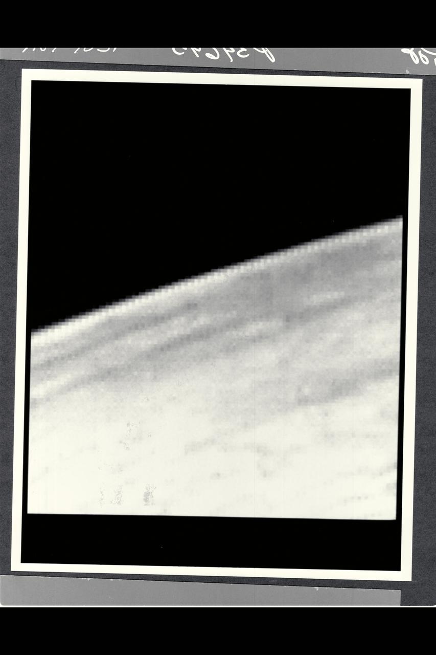
Range : 168,694 km (105,000 mi.) Voyager 2 discovered detached limb hazes in the atmosphere of Triton in Pictures that arrived at Earth between 3:30 am and 5:30 am. The principal layer seen here begins about three km (2 miles) above the surface, and is about 3 km thick. Fainter upward extension of the haze has been seen to an altitude of at least 14 km (9 mi.). The haze must be comoposed of tiny particles in order to be supported in Trition's thin atmosphere. Composition of the haze is currently unknown, but may be either condensed atmospheric gases or complex orgainc molecules produced by irradiation of the methane in Triton's atmosphere. The vaguely linear mottling on the surface may be shadows of other haze striations. Other features of the haze layer should be appaarent in images of Triton taken at higher phase angles (including crescent phase). The image shows features as small as 2 km (1.2 mi) wide.
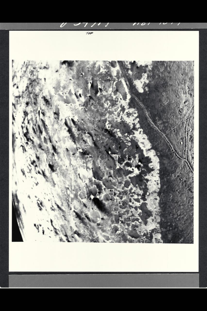
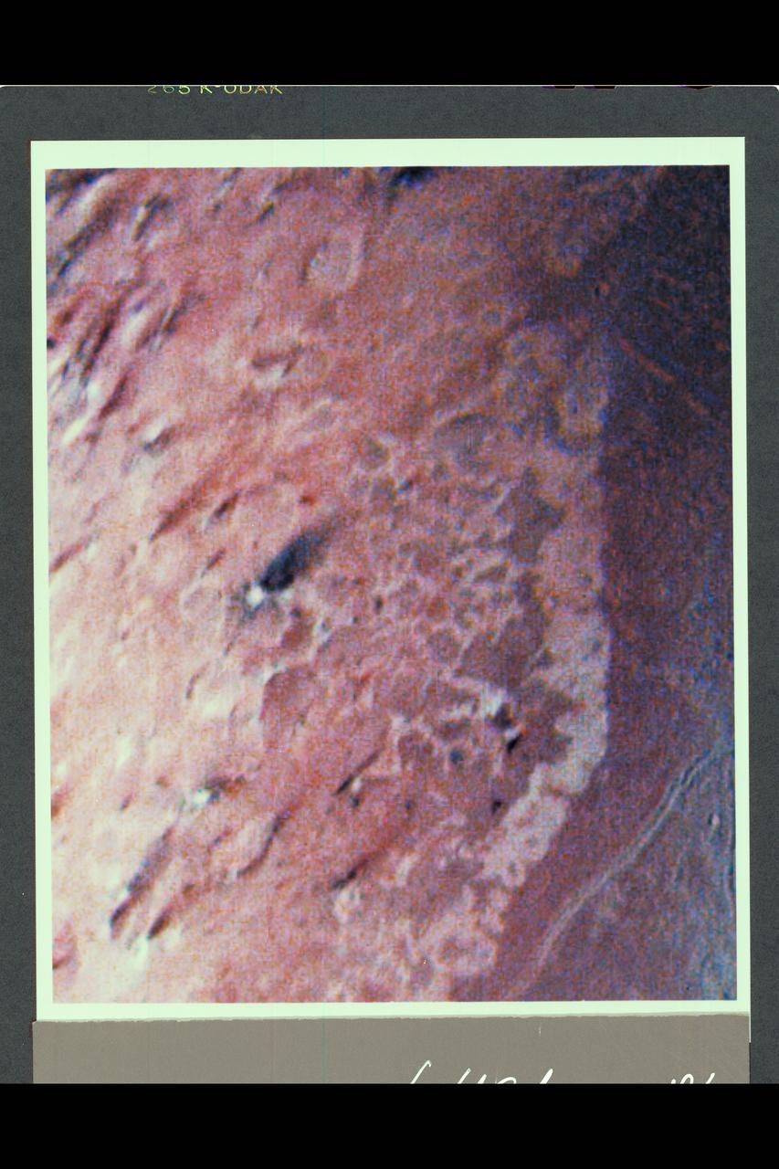
P-34692 Range : 500 km. ( 300 miles ) Smallest Resolvable Feature : 900 m. or 2,700 ft. Part of Triton's complex geological history canbe seen in this image, shot by Voyager 2. Part of a sequence, it shows a surface dominated by many roughly circular, polygonal, and arcuate features between 30 and 50 km (18 and 30 miles ) across. Some resemble degraded impact craters of Mars, while others resemble the 'palimpsest' features of Jupiter's satellite Ganymede. Peculiar intersecting, double ridged lines are 15 to 20 km. or 9 to 12 miles wide and hundreds of kilometers long. Theyresemble some deformational belts of Ganymede. Patches of plainsforming material tend to occur in local depressions. The geologic features of Triton and spectroscopic information indicates that the surface of Triton is underlain by a mixture of ices.
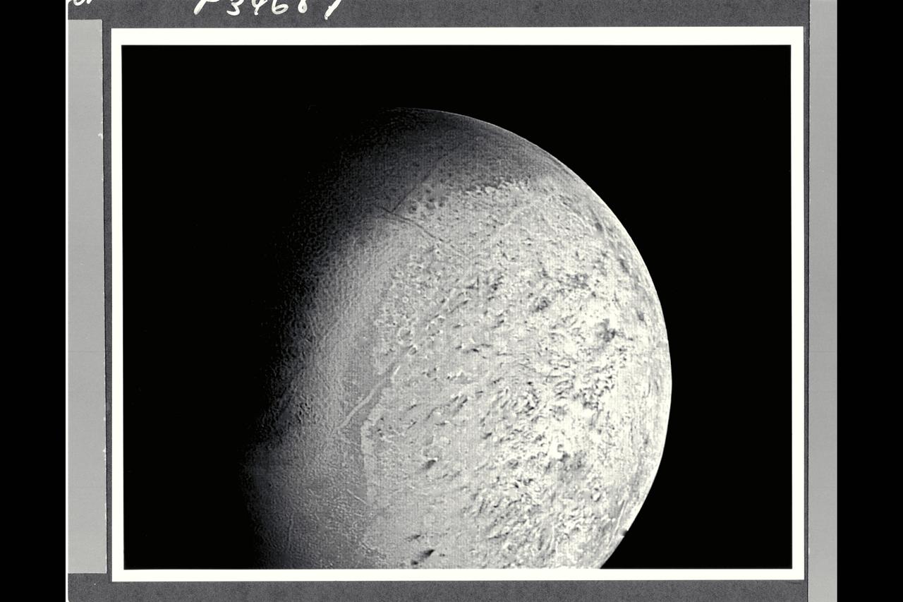
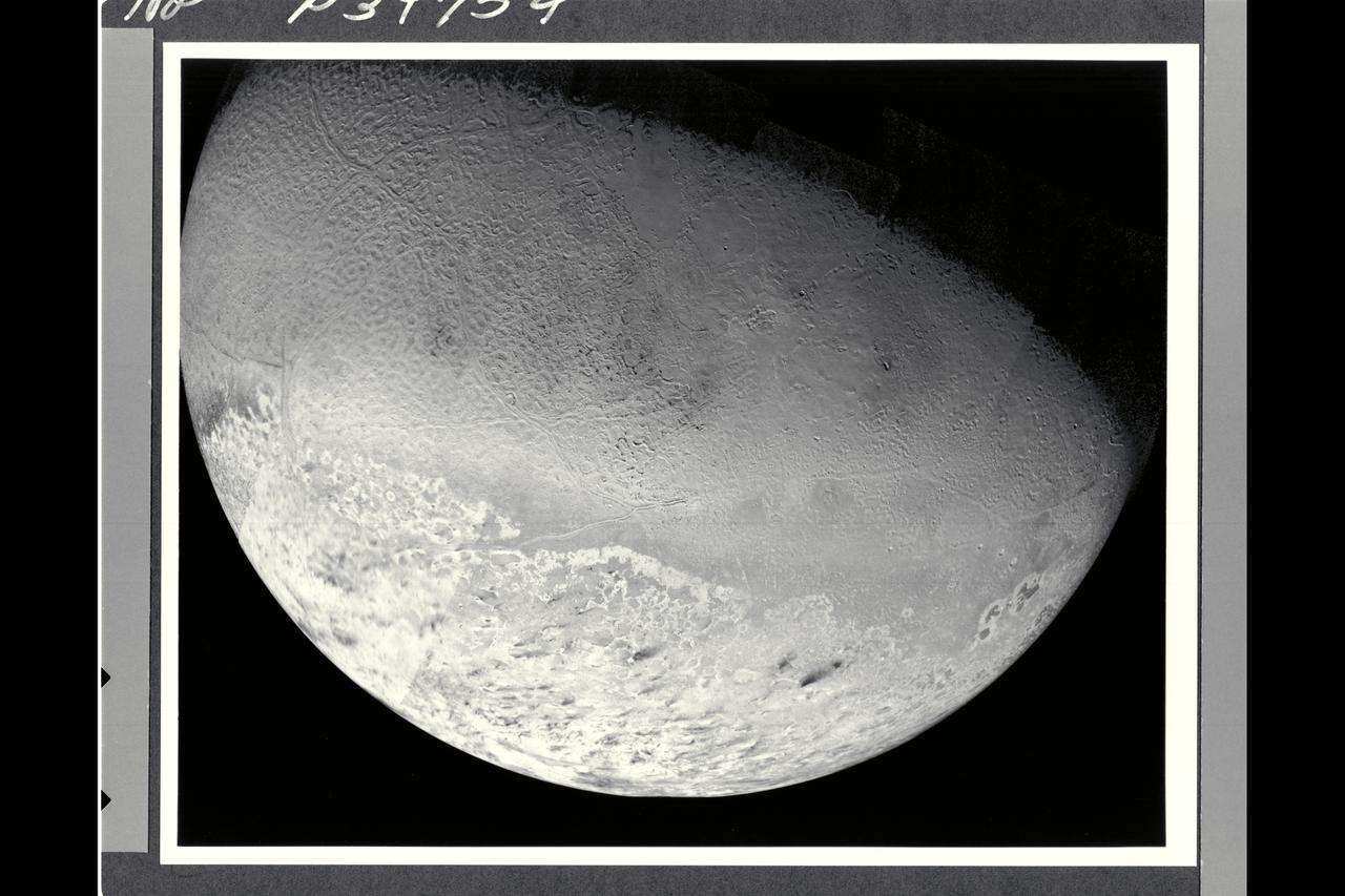
P-34687 Range : 530,000 km. ( 330,000 miles ) Smallest Resolvable Feature : 10 km or 6 miles This Voyager 2 image of Neptune's satellite Triton shows the first photo of Triton to reveal surface topography. The south pole, continuously illuminated by sunlight at this season, ia at bottom left. the boundary between bright southern hemisphere and the darker and the darker, northern hemisphere is clearly visible. Both the darker regions to the north and the very bright sub-equatorial band show a complex pattern of irregular topography that somewhat resembles 'fretted terrain' on parts of Venus and Mars. The pattern of dark and light regions over most of the southern hemisphere will require higher resolution images for interpretation. Also evident are long, straight lines that appear to be surface expressions of internal, tectonic processes. No large impact ctaters are visible, suggesting that the crust of Triton has been renewed relatively recently, that is, within the last bllion years or less.
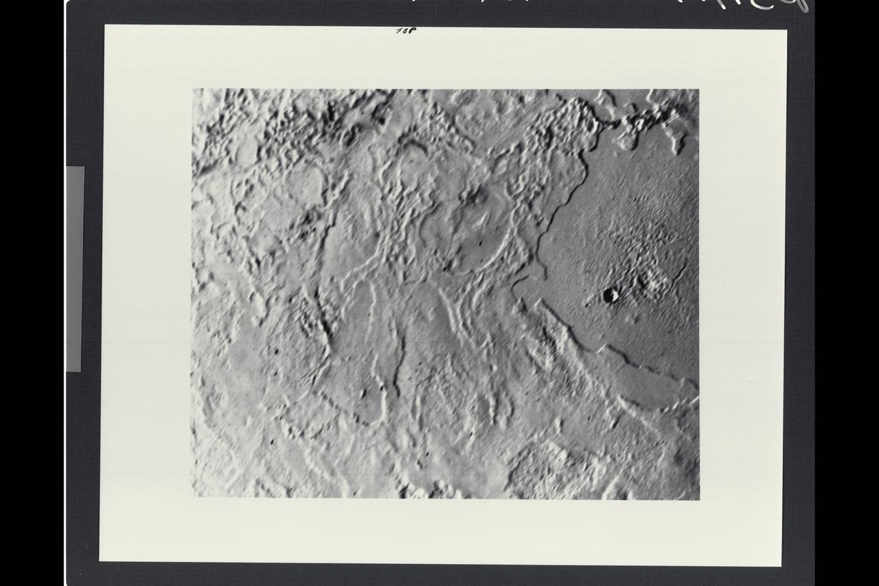
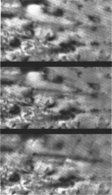
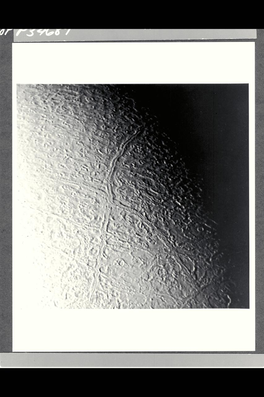
P-34717 Range: 80,000 kilometers (50,000 miles) This image taken by Voyager 2 of Neptune's largest satellite, Triton, shows an area in the northern hemisphere. The Sun is just above the horizon, so features cast shadows that accentuate height differences. The large, smooth area in the right-hand side of the image shows a single, fresh, impact crater. Otherwise there is no evidence of impacts such as those that have pocked the faces of most of the satellites Voyager 2 has visited. Many low cliffs in the area, bright where they face the Sun, and dark when they face away from it, suggest an intricate history for Triton. The cliffs might be due either to melting of surface materials or, possibly, caused by unusual fluid materials that flowed sometime in Triton's past.
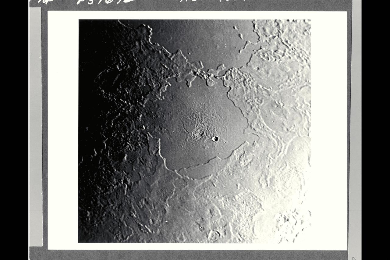
P-34692 Range : 500 km. ( 300 miles ) Smallest Resolvable Feature : 900 m. or 2,700 ft. Part of Triton's complex geological history canbe seen in this image, shot by Voyager 2. Part of a sequence, this photograph encompasses two depressions, possibly old impact basins, that have been extensively modified by floodind, melting, faulting, and collapse. Several episodes of filling and partial removal of material appear to have occurred. The rough area in the middle of the bottom depression probably marks the most recent eruption of material. Only a few impact craters dot the area, which shows the dominance of internally driven geologic processes on Triton.
Voyager II Imagery, Neptune: This is one of the most detailed views of the surface of Triton taken by Voyager 2 on its flyby of the large satellite of Neptune early in the morning of August 25, 1989. The picture was stored on the tape recorder and relayed to Earth later. Taken from a distanT ce of only 40,000 km (25, 000 miles), the frame is about 220 kilometers (140 miles) across and shows details as small as 750 meters (0.5 miles). Most of the area is covered by a peculiar landscape of roughly circular depressions separated by rugged ridges. This type of terrain, which covers large tracts of Triton's northern hemisphere, is unlike anything seen elsewhere in the solar system. The depressions are probably not impact craters: They are too similar in size and too regularly spaced. Their origin is still unknown, but may involve local melting and collapse of the icy surface. A conspicuous set of grooves and ridges cuts across the landscape, indicating fracturing and deformation of Triton's surface. The rarity of impact craters suggests a young surface by solar-system standards, probably less than a few billion years old. The Voyager Mission is conducted by JPL for NASA's Office of Space Science and Applications. (JPL ref: P-34722 Voyager N-60 )
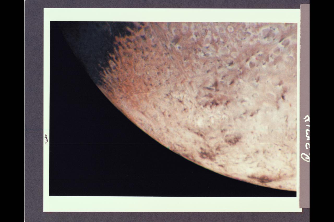
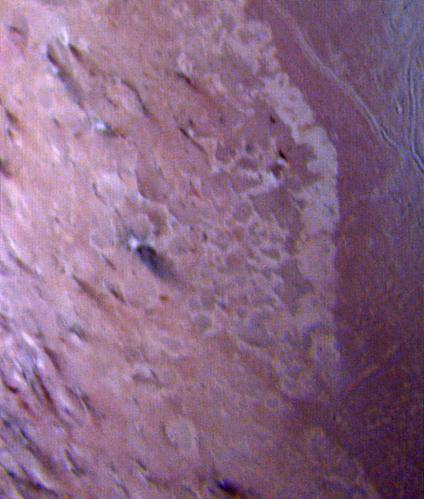
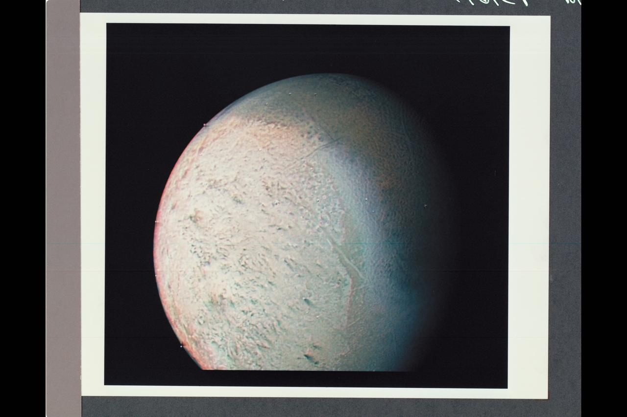
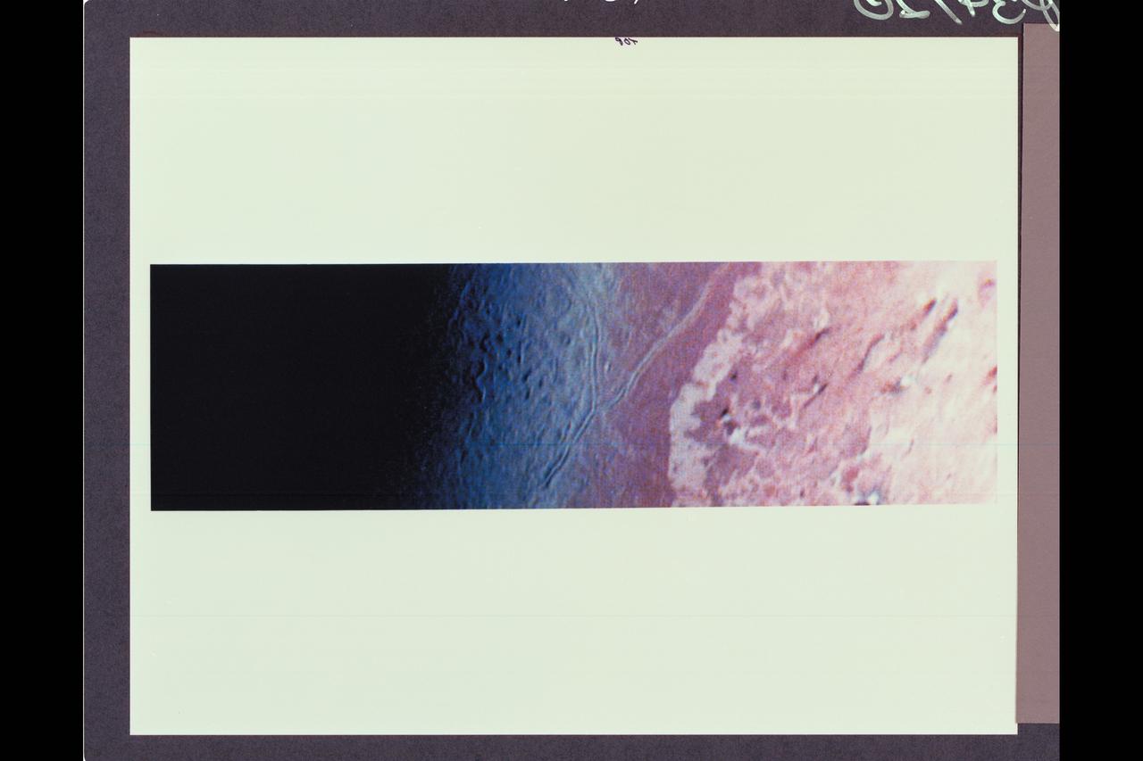
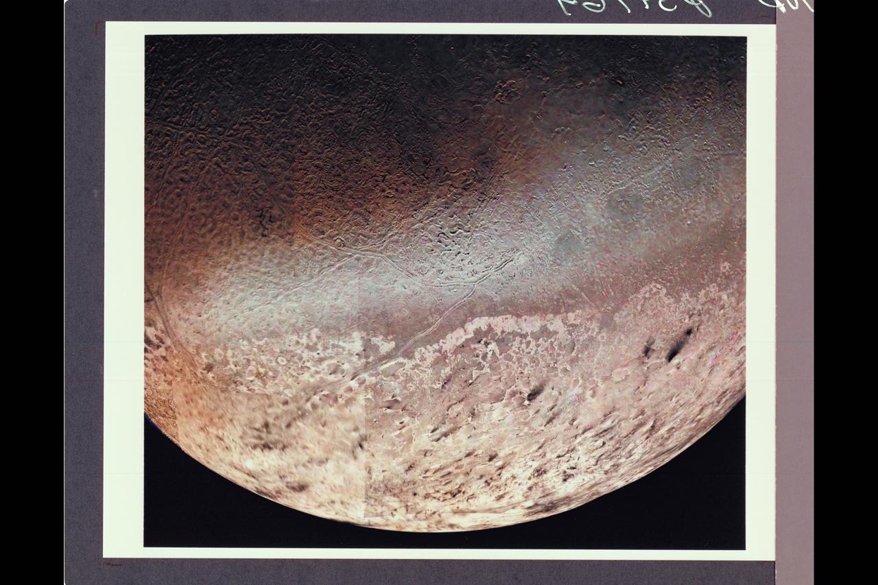
P-34718 Range: 210,000 kilometers (128,000 miles) This natural color image of the limb of Triton shows the largest surface features at about 3 miles across. The picture is a composite of images taken through the violet, green and clear filters and shows a geologic boundary between a rough, pitted surface to the right and a smoother surface to the left. The change between surface types is gradual. The image also shows a color boundary between pinkish material in the upper part of the image and whiter material in the lower part. The geologic and color boundaries are not the same. That implies that whatever supplies the color is a very thin coating over a different underlying material in which the geologic boundary occurs. The colored coating may be a seasonal frost composed of compounds volatile enough to be sublimated at the very low temperatures (40 K to 50 K or -387.4 F to -369.4 F) prevailing near Triton's surface. Possible compositions of the frost layer include methane (which turns red when irradiated), carbon monoxide or nitrogen. The color in this image is somewhat exaggerated: Triton is primarily a white object with a pinkish cast in some areas.
Range : 4 million km. ( 2.5 million miles ) P-34654 This Voyager 2 image of Neptune's satteltite Triton was made by combining images taken through the green, clear, and violet filters. The smallest feature seen are about 74 km, or 46 miles accross. The south pole of Triton is currently tipped toward the sun and it is summer in the southern hemisphere. The south pole is located about a quarter of the way up from the bottom if the image. The bright band near the top of the image nearly coincides with the equator of Triton. One prominent and several smaller bright, wispy streaks extend from the band into the darker northern hemisphere. The prominent wispy streak shows bluish-white color, while the darker northern hemisphere is reddish in color. This may indicate that the streak is freshly deposited frost while the red color in the northern hemisphere may result from methane frost that has been darkened by radiation. Individual markings appear to rotate with the satellite and retain their shapes indicating they are indeed surface features and not in the tenuous atmosphere.
Range : 4 million km (2.5 million miles) Already-intriquing patterns of unknown origin appear on the surgace of Neptune's largest satellite, Trition, in this image from Voyager 2. Voyager images show that Trition's diameter is about 2,720 km (1,690 miles), and that it is one of the brightest objects in the solar system, reflecting about 70 percent of the sunlight that strikes it. THis is the hemisphere of Triton that always faces away from Neptune. The south pole is near the botton of the image. Triton's rotation axis is tilted so that the latitude at the center of the disk is 55 degrees south. Dark regions at the top of the disk extend from roughly the equator to beyond 20 degrees north. The margin between the bright and dark regions varies with longitude around the satellite. The gray, featureless area just to the right of the center of the disk is due to a reseau (reticule mark) in the camera.
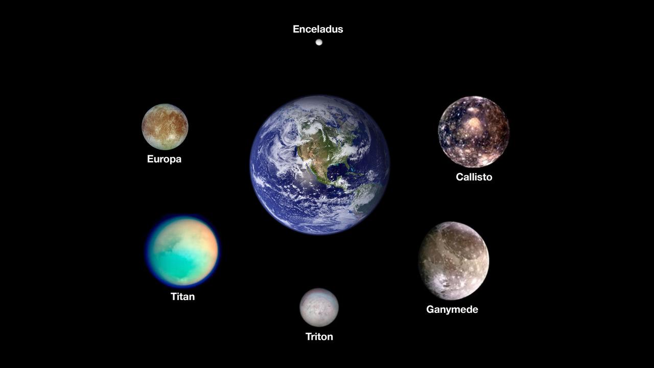
Scientists think six icy moons in our solar system may currently host oceans of liquid water beneath their outer surfaces. Arranged around Earth are images from NASA spacecraft of, clockwise from the top, Saturn's moon Enceladus, Jupiter's moons Callisto and Ganymede, Neptune's moon Triton, Saturn's moon Titan, and Jupiter's moon Europa, the target of NASA's Europa Clipper mission. The worlds here are shown to scale. The images of the Saturnian moons were taken by NASA's Cassini mission. The images of the Jovian moons were taken by NASA's Galileo mission. The image of Triton was taken by NASA's Voyager 2 mission. The image of Earth was stitched together using months of satellite-based observations, mostly using data from the Moderate Resolution Imaging Spectroradiometer (MODIS) on NASA's Terra satellite. https://photojournal.jpl.nasa.gov/catalog/PIA26103
Voyager violet, green and ultraviolet images of Triton were map projected into cylindrical coordinates and combines to produce this false-color terrain map. Several compositionally distinct terrain and geologic features are portrayed. At center is a gray-blue unit referred to as 'cantaloupe' terrain because of its unusual topographic texture. The unit appears to predate other units to the left. Immediately adjacent to the cantaloupe terrain, is a smoother unit, represented by a reddish color, that has been dissected by a prominent fault system. This unit apparently overlies a much-higher-albedo material, seen farther left. A prominent angular albedo boundary separates relatively undisturbed smooth terrain from irregular patches which seem to emanate from circular, often bright-centered features. The parallel streaks may represent vented particulate materials blown in the same direction by winds in Triton's thin atmosphere.
This photomosaic of Triton, assembled from 14 individual frames, shows the great variety of its surface features. At the bottom of the image are remnants of the south polar cap, containing 'dark' streaks generally aligned towards the northeast (upper right in the image). Even though these are darker than other features on Triton, they reflect nearly ten times as much light as the surface of the Earth's moon. North of the cap, in the western (left) half of the disk is the region which has been informally dubbed the 'cantaloupe' terrain. Small dimples with upraised rims and shallow central depressions dot the area. Long fractures have opened allowing some icy material to ooze up and form a central ridge. These criss-cross the region and extend into parts of the polar cap region. Towards the south this terrain has a light covering of frost. Running east to the limb of Triton, just north of the polar cap, is an area of smooth plains and low hills which is the most densely cratered region seen. In the northeast (upper right) of this image are plains which show evidence for extensive resurfacing, including possible extrusions of flowing material onto the surface. This region also contains two large smooth areas reminiscent of the maria of the Earth's moon which were formed by large-scale volcanic flooding. Near the eastern (right) limb of Triton are three darker gray markings with sharply defined brighter borders. These are unlike anything else seen in the solar system, and their origin is not yet understood.
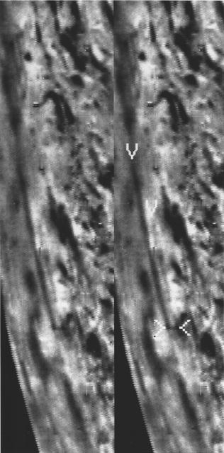
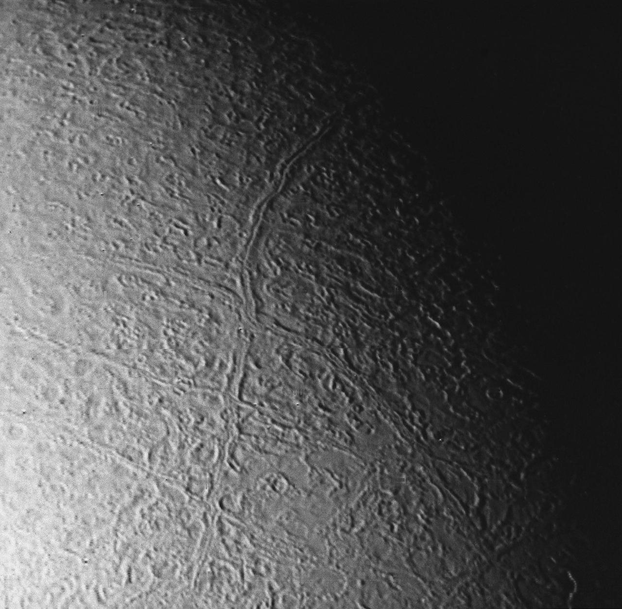
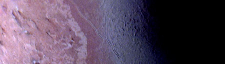
P-34689 Range : 130,000 km. ( 80,000 miles ) Smallest Resolvable Feature : 2.5 km or 1.5 miles This image of Neptune's moon Triton, shot by Voyager 2, is seen here. The long linear feature exteding vertically across the image is probably a graben -- a norrow down-dropped fault block about 35 km. or 20 miles across. The ridge in the center of the graben. The surrounding terrain is a relatively young icy surface with few impact craters.

Voyager 2 was the first spacecraft to observe the planet Neptune and its two satellites: Triton, the largest, and Nereid. The most obvious feature of the planet is its blue color, the result of methane in the atmosphere. Research continues on Neptune's two largest satellites and the additional six that were discovered by Voyager 2's investigation. These images represent the most complete set of full disk Neptune images that the spacecraft will acquire.
P-34714 This image of the south polar terrain of Triton reveals about 50 dark plumes or 'wind streaks' on the icy surface. The plumes originate at very dark spots generally a few miles in diameter and some are more than 100 miles long. The spots which clearly mark the source of the dark material may be vents where gas has erupted from beneath the surface and carried dark particles into Triton's nitrogen atmosphere. Southwesterly winds then transported the erupted particles, which formed gradually thinning deposits to the northeast of most vents. It is possible that the eruptions have been driven by seasonal heating of very shallow subsurface deposits of volatiles, and the winds transporting particles similiarly may be seasonal winds. The polar terrain, upon which the dark streaks have been deposited, is a region of bright materials mottled with irregular, somewhat dark patches. The pattern of irregular patches suggests that they may correspond to lag deposits of moderately dark material that cap the bright ice over the polar terrain.
P-34764 Voyager 2 obtained this high resolution color image of Neptune's large satellite Triton during its close flyby. Approximately a dozen individual images were combined to produce this comprehensive view of the Neptune-facing hemisphere of Triton. Fine detail is provided by high resolution, clear-filter images, with color information added from lower resolution frames. The large south polar cap at the bottom of the image is highly refective and slightly pink in color , and may consist of a slowly evaporating layer of nitrogen ice deposited during the previous winter. From the ragged edge of the polar cap northward the satellite's face is generously darker and redder in color. This coloring may be produced by the action of ultraviolet light and magnetospheric radiation upon methane in the atmosphere and surface. Running across this darker region , approximately parallel to the edge of the polar cap, is a band of brighter white material that is almost bluish in color. The underlying topography in this bright band is similiar, however to that in the darker, redder regions surrounding it.
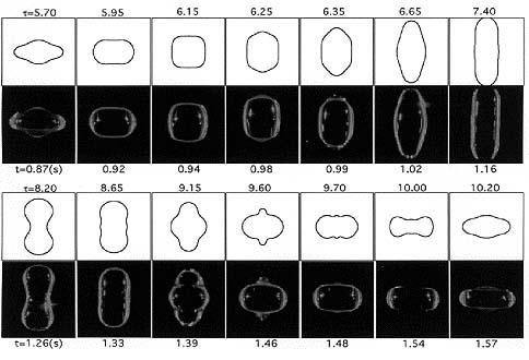
Apfel's excellent match: This series of photos shows a water drop containing a surfactant (Triton-100) as it experiences a complete cycle of superoscillation on U.S. Microgravity Lab-2 (USML-2; October 1995). The time in seconds appears under the photos. The figures above the photos are the oscillation shapes predicted by a numerical model. The time shown with the predictions is nondimensional. Robert Apfel (Yale University) used the Drop Physics Module on USML-2 to explore the effect of surfactants on liquid drops. Apfel's research of surfactants may contribute to improvements in a variety of industrial processes, including oil recovery and environmental cleanup.
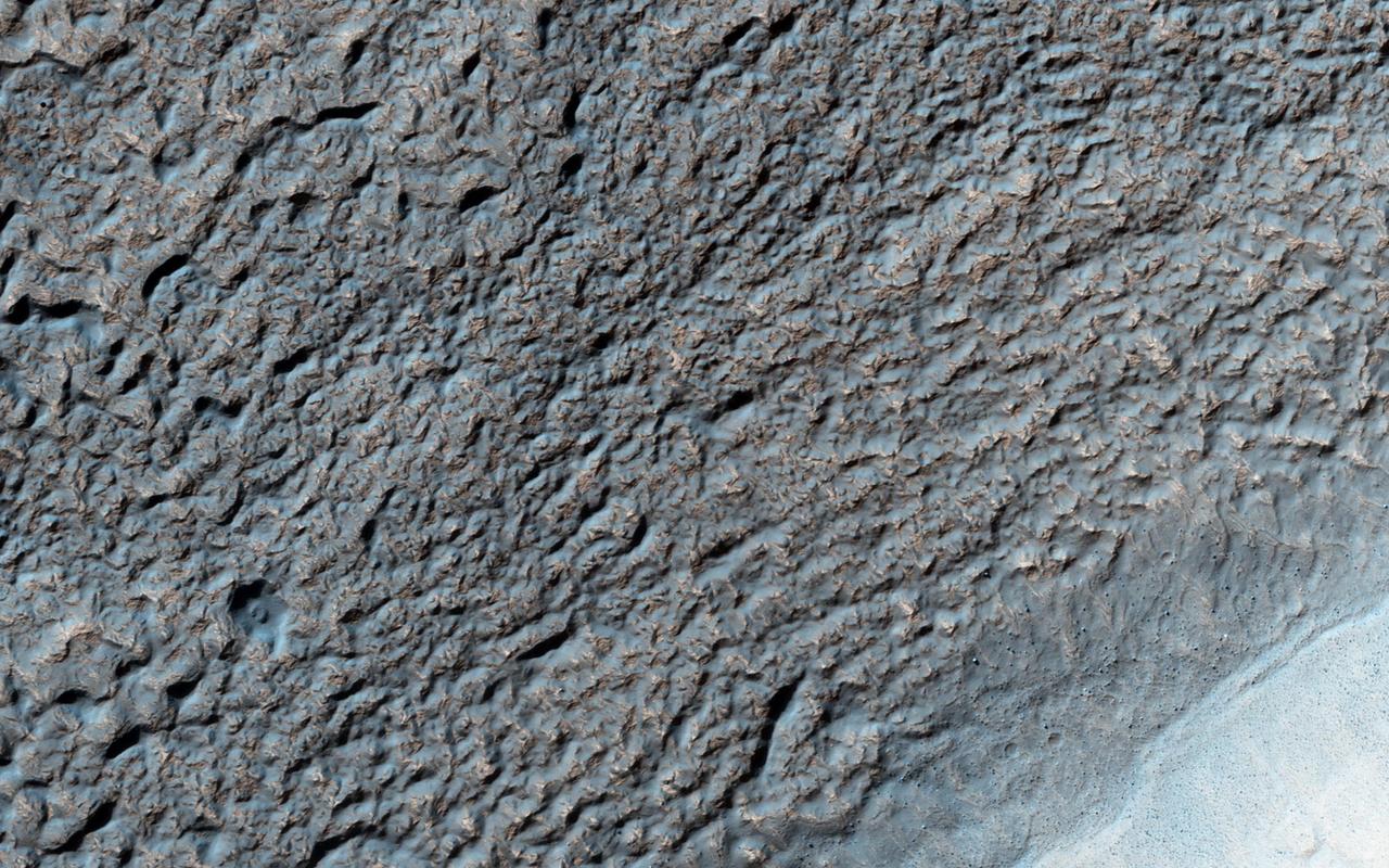
Like Earth's water table, Mars has an ice table. Sometimes, the ice table coincides with the ground's surface as it does here. The knobby, pitted terrain is caused when ice is deposited and then sublimates over and over again. This geologic process is called "accrescence" and "decrescence" and also occurs on Neptune's moon Triton and on Pluto, though in the outer Solar System the ice is not water ice. Other evidence for ice here includes the rope-like, curved flow feature that resembles glacial flow. Solis Planum -- a huge mound south of Valles Marineris -- is the location of this image. http://photojournal.jpl.nasa.gov/catalog/PIA20208
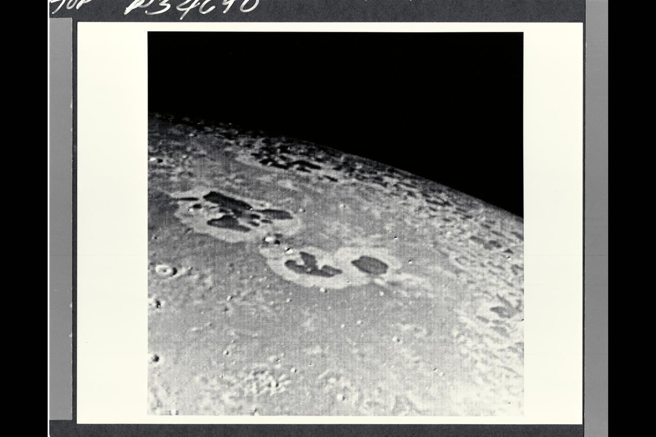
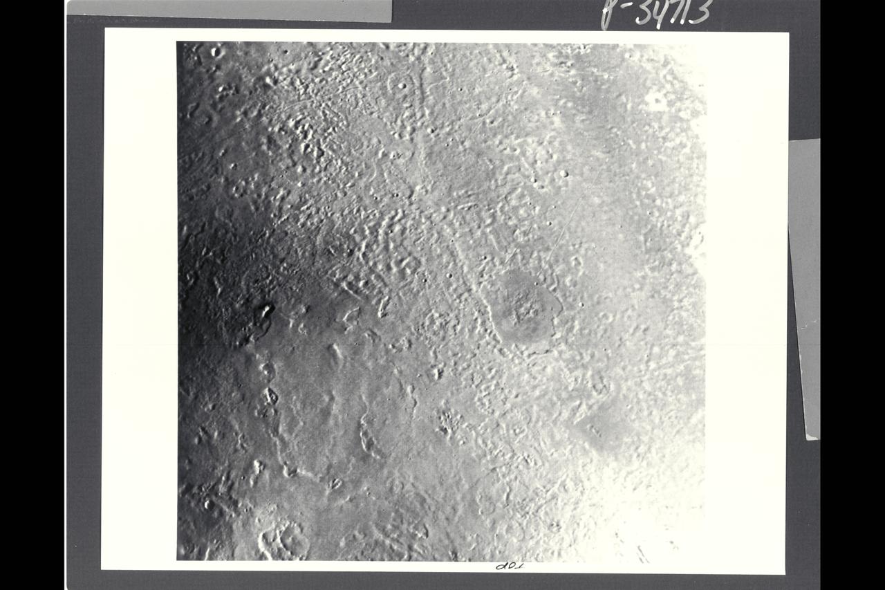
P-34668 This narrow angled image of Neptune's Triton, part of a sequence recieved from Voyager 2 shows a large flooded basin about 200 km. or 120 miles wide and 400 km. or 240 miles long. It appears to have been formed chiefly by two large, ancient craters. The walls of the basin have retreated, possibly as a consequence of sapping or collapse into the fluid that filled the main floor. The vent from which the flood evidently erupted lies near the right hand end of the basin. The surface of the eruptive material is rough near the vent and along the center of the basin, perhaps as a consequence of the presence of large rafts of ice. The absence of resolved impact craters on the floor of the basin indicatyes a young age for the flood.

Range : 4.86 million km (3 million mi.) This dramatic view of the crescents of Neptune and Triton was acquired by Voyager 2 approx. 3 days, 6 1/2 hours after its closest approach to Neptune. The space craft was pluging southward at an angle of 48 degrees to the plane of the ecliptic. This direction, combined with the current season of southern summer in the Neptune system, gives this picture its unique geometry. The smallest detail discernible is approx. 90 km (56 mi.). Color was produced using images taken through the narrow-angle camera's clear, orange and green filters. Neptune does not appear as blue from this viewpoint because the forward scattering nature of its atmosphere is more important than its absorption of red light at this high phase angle (134 degrees).
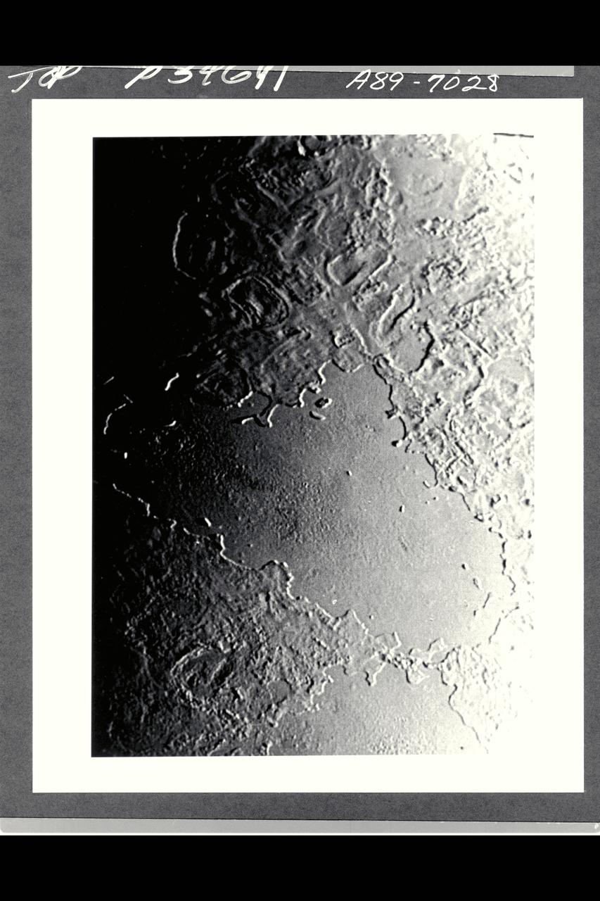
P-34713 This Voyager image of Triton reveals two kinds of mid-latitude terrain. Near the center and the lower half of the frame is a gently rolling terrain pock-marked with a modest number of impact craters. The density of impact craters is somewhat similiar to that found on the mare surface of Earth's moon. Crossing this rolling surface are narrow rifts, one of which grades into a chain of craters that probably are of collapse origin. In the upper right part of the frame is a smooth terrain with very sparse impact craters. This terrain evidently has been formed by flooding of the surface by low-viscosity fluids rather late in geologic time. One of the vents from which these fluids erupted probably is represented by a deep, elongate crater near the middle of the right side of the image. Two slightly dark regions underlain by late eruptive material also occur in the left half of the image. Apparent vents for these eruptions are marked by shallow depressiions, which may have been formed by drain back of material at the end of the eruptive episode.
Range : 190,000 km ( 118,000 mi.) This false color image of Triton is a composite of images taken through the violet, green and ultraviolet filters. The smallest visible features are about 4 km (2.5 mi.) across. The image shows a geologic boundary between completely dark materials and patchy light/dark materials. A layer of pinkish material stretches across the center of the image. The pinkish layer must be thin because underlying albedo patterns show through. Several features appear to be affected by the thin atmosphere; the elongated dark streaks may represent particulate materials blown in the same direction by previaling winds, and the white material may be frost deposits. Other features appear to be volcanic deposits including the smooth, dark materials alongside the long, narrow canyons. The streaks themselves appear to originate from very small circular sources, some of which are white, like the source of the prominent streak near the center of the image. The sources may be small volcanic vents with fumarolic-like activity. The colors may be due to irradiated methane, which is pink to red, and nitrogen, which is white.
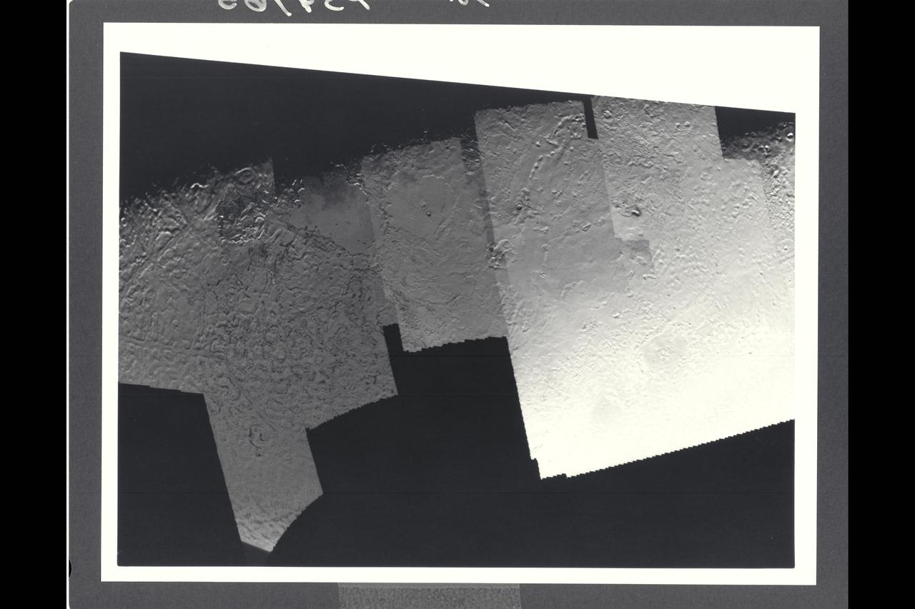
Range : 40,000 km (24,8000 mi.) This picture of Triton is a mosaic of the highest resolution images taken by Voyager 2. The mosaic is superimposed on the lower-resolution mapping images taken about 2 hours earlier in order to fill in gaps between high-resolution images. The smallest features that can be seen on the images are about 0.8 km (0.5 mi.) across. The terminator (line separation day and night) is at the top of the picture and is centered at about 30 degrees north latitude and 330 degrees longitude. These highest-resolution images were targeted for the terminator region to show details of the topography by the shadows it casts. Near the center of the picture is a depression filled with smooth plains that are probably ices which were once erupted in a fluid state. The depth of the depression is about 300 meters (900 feet) and the prominent fresh impact crater on its floor is about 20 km (12 mi.) in diameter and about 1 km (0.6 mi.) deep. On the right is a elongate crater with adjacent dark deposits about it. This feature may be an explosive eruption vent formed by gaps within the ice. The linear structure on the lest is probably a fracture along which fresh ice has been extruded.
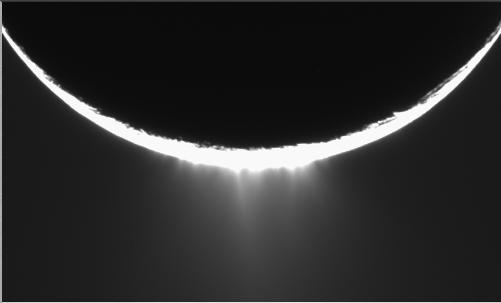
Jets of icy particles burst from Saturn’s moon Enceladus in this brief movie sequence of four images taken on Nov. 27, 2005. The sensational discovery of active eruptions on a third outer solar system body (Io and Triton are the others) is surely one of the great highlights of the Cassini mission. Imaging scientists, as reported in the journal Science on March 10, 2006, believe that the jets are geysers erupting from pressurized subsurface reservoirs of liquid water above 273 degrees Kelvin (0 degrees Celsius). Images taken in January 2005 appeared to show the plume emanating from the fractured south polar region of Enceladus, but the visible plume was only slightly brighter than the background noise in the image, because the lighting geometry was not suitable to reveal the true details of the feature. This potential sighting, in addition to the detection of the icy particles in the plume by other Cassini instruments, prompted imaging scientists to target Enceladus again with exposures designed to confirm the validity of the earlier plume sighting. The new views show individual jets, or plume sources, that contribute to the plume with much greater visibility than the earlier images. The full plume towers over the 505-kilometer-wide (314-mile) moon and is at least as tall as the moon's diameter. The four 10-second exposures were taken over the course of about 36 minutes at approximately 12 minute intervals. Enceladus rotates about 7.5 degrees in longitude over the course of the frames, and most of the observed changes in the appearances of the jets is likely attributable to changes in the viewing geometry. However, some of the changes may be due to actual variation in the flow from the jets on a time scale of tens of minutes. Additionally, the shift of the sources seen here should provide information about their location in front of and behind the visible limb (edge) of Enceladus. These images were obtained using the Cassini spacecraft narrow-angle camera at distances between 144,350 and 149,520 kilometers (89,695 and 92,907 miles) from Enceladus and at a phase angle of about 161 degrees. Image scale is about 900 meters (2,950 feet) per pixel on Enceladus. A movie is available at http://photojournal.jpl.nasa.gov/catalog/PIA07762