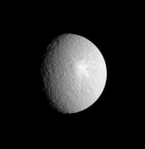
Tirawa at Twilight

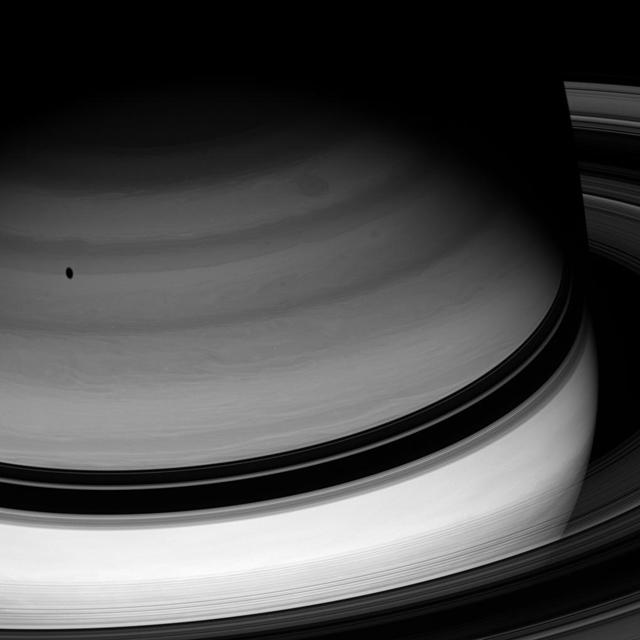
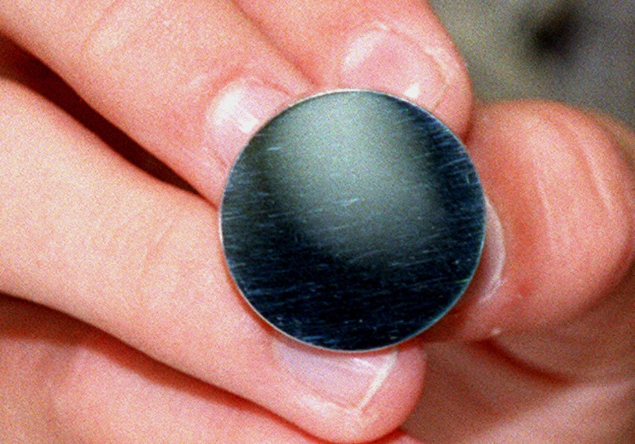
Ring of Twilight
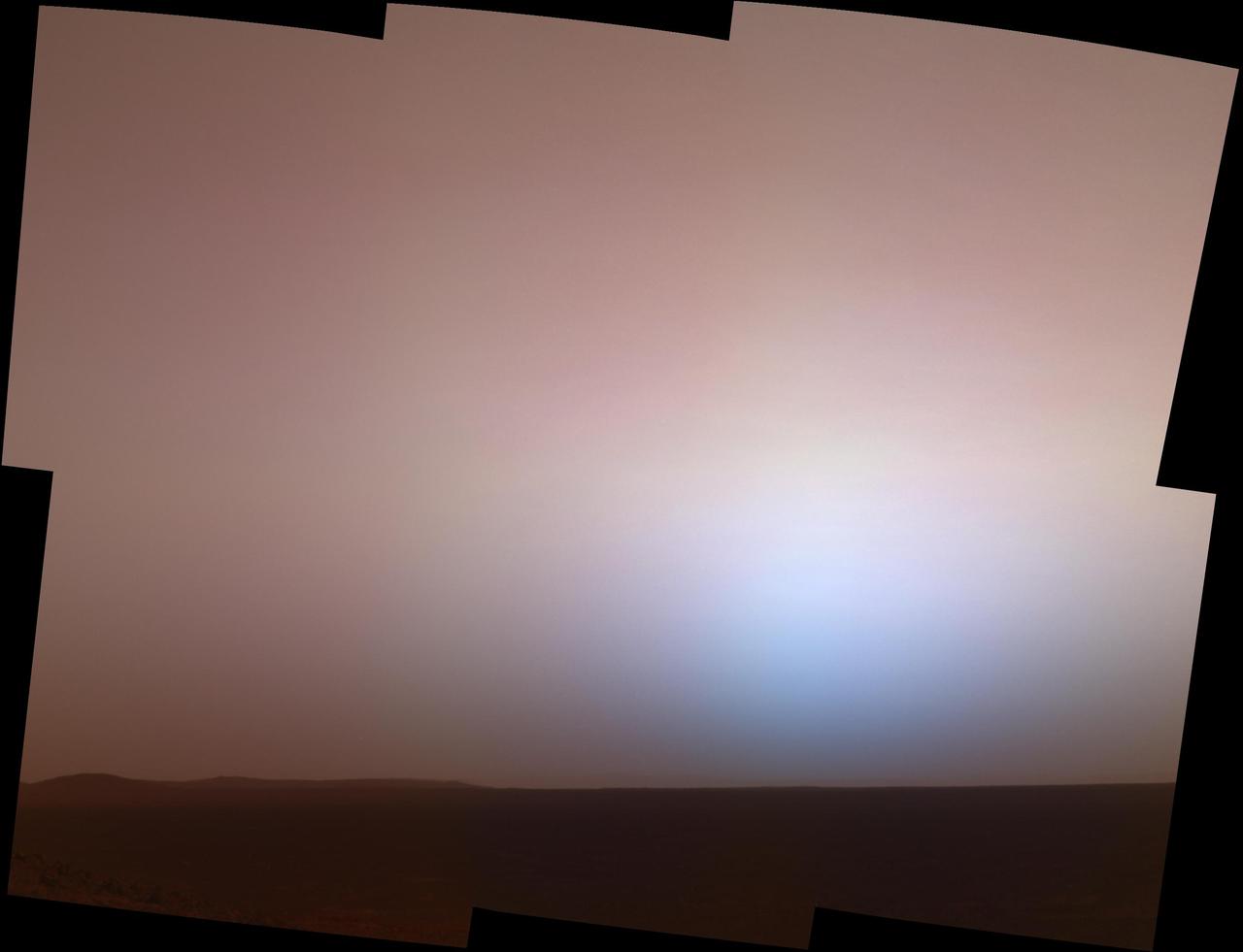
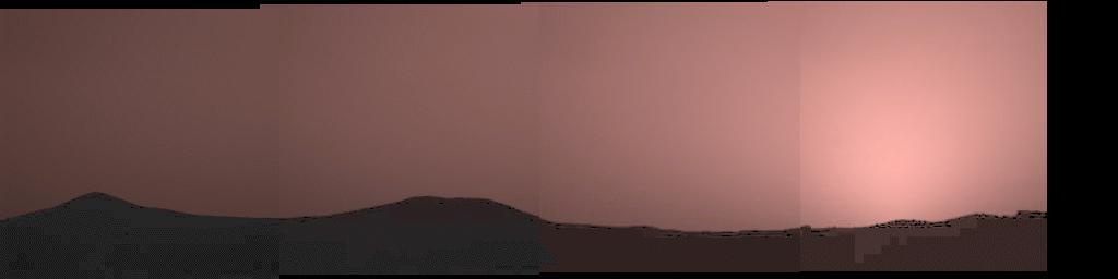
Twilight at Gusev

Dunes in Twilight
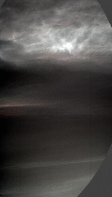
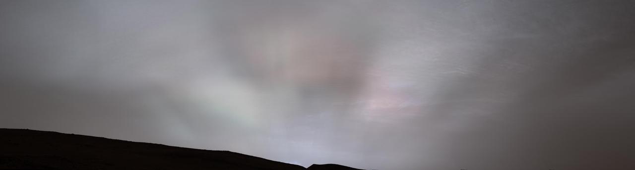
Twilight Realm
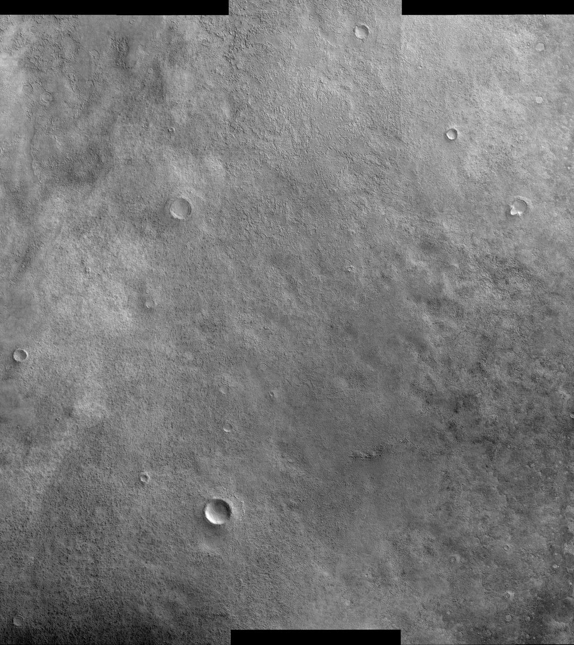
Twilight Imaging of Kepler Crater Floor
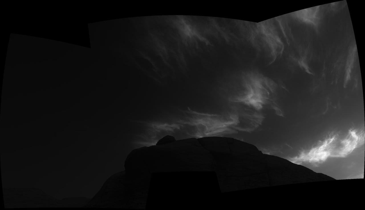
NASA's Curiosity Mars rover used its left Mast Camera, or Mastcam, to capture these drifting noctilucent, or twilight, clouds on Jan. 17, 2025, the 4,426th Martian day, or sol, of the mission. The left Mastcam has a stuck color filter wheel, which is why part of the imagery appears cut off in three corners. The original recording taken by Curiosity was 16 minutes; this video has been speeded up by about 480 times (and it loops four times). The clouds at the top of the frame, including the falling white plumes, are made of carbon dioxide ice. The plumes are an estimated 37 to 50 miles (60 to 80 kilometers) above the Martian surface; they could fall as low as 31 miles (50 kilometers) above the surface before they would evaporate due to rising temperatures. In the lower half of the frame at the beginning of the video, a different set of very faint clouds is visible. These are water-ice clouds are hovering at roughly 31 miles (50 kilometers) in altitude. The brightness has been stretched to make certain colors more visible in this enhanced-color imagery. This is the fourth Mars year that twilight clouds have been observed by Curiosity; previous observations were made in 2019, 2021, and 2023. Animation available at https://photojournal.jpl.nasa.gov/catalog/PIA26519
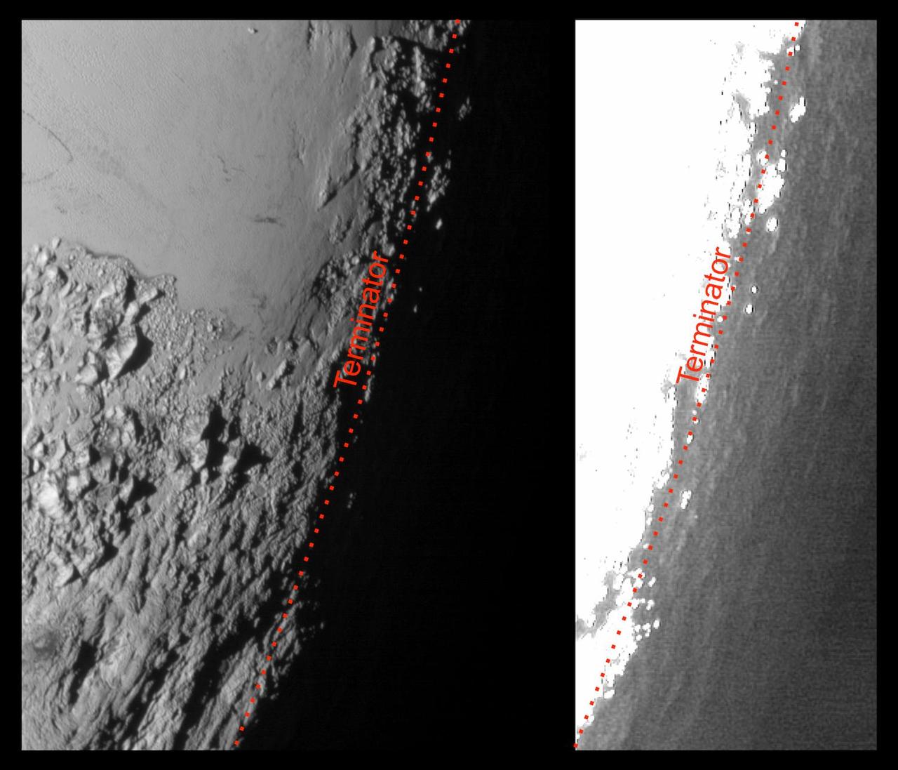
This image of Pluto from NASA's New Horizons spacecraft, processed in two different ways, shows how Pluto's bright, high-altitude atmospheric haze produces a twilight that softly illuminates the surface before sunrise and after sunset, allowing the sensitive cameras on New Horizons to see details in nighttime regions that would otherwise be invisible. The right-hand version of the image has been greatly brightened to bring out faint details of rugged haze-lit topography beyond Pluto's terminator, which is the line separating day and night. The image was taken as New Horizons flew past Pluto on July 14, 2015, from a distance of 50,000 miles (80,000 kilometers). http://photojournal.jpl.nasa.gov/catalog/PIA19931
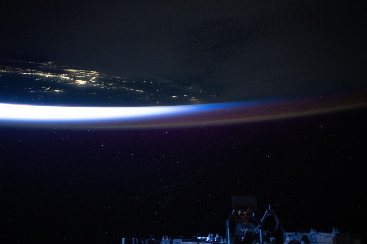
iss073e0035649 (April 20, 2025) --- An orbital twilight reveals Earth's horizon and contrasts with the well-lit coast of southern California in this photograph from the International Space Station as it orbited 258 miles above the Pacific Ocean at approximately 4:46 a.m. local time.

This image captures the swirling cloud formations around the south pole of Jupiter, looking up toward the equatorial region. NASA's Juno spacecraft took the color-enhanced image during its eleventh close flyby of the gas giant planet on Feb. 7 at 7:11 a.m. PST (10:11 a.m. EST). At the time, the spacecraft was 74,896 miles (120,533 kilometers) from the tops of Jupiter's clouds at 84.9 degrees south latitude. Citizen scientist Gerald Gerald Eichstädt processed this image using data from the JunoCam imager. This image was created by reprocessing raw JunoCam data using trajectory and pointing data from the spacecraft. This image is one in a series of images taken in an experiment to capture the best results for illuminated parts of Jupiter's polar region. To make features more visible in Jupiter's terminator -- the region where day meets night -- the Juno team adjusted JunoCam so that it would perform like a portrait photographer taking multiple photos at different exposures, hoping to capture one image with the intended light balance. For JunoCam to collect enough light to reveal features in Jupiter's dark twilight zone, the much brighter illuminated day-side of Jupiter becomes overexposed with the higher exposure. https://photojournal.jpl.nasa.gov/catalog/PIA21980. - Enhanced image by Gerald Eichstädt based on images provided courtesy of NASA/JPL-Caltech/SwRI/MSSS
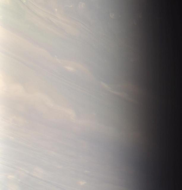
In Saturn bluish north, day ends for the dreamy white clouds that stretch here into twilight
Using the navigation cameras on its mast, NASA's Curiosity Mars rover took these images of clouds just after sunset on March 28, 2021, the 3,072nd so, or Martian day, of the mission. These noctilucent, or twilight clouds, are made of water ice; ice crystals reflect the setting sun, allowing the detail in each cloud to be seen more easily. Movie available at https://photojournal.jpl.nasa.gov/catalog/PIA24646
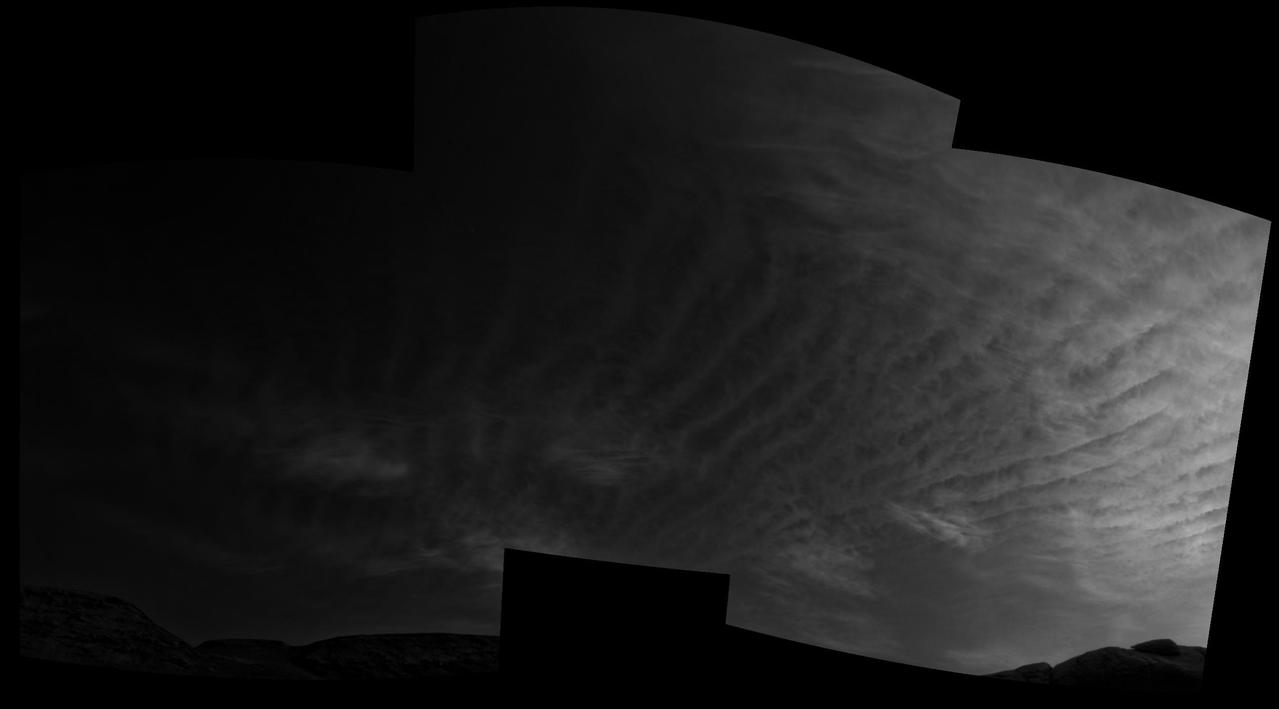
Using the navigation cameras on its mast, NASA's Curiosity Mars rover took these images of clouds just after sunset on March 31, 2021, the 3,075th so, or Martian day, of the mission. These noctilucent, or twilight clouds, are made of water ice; ice crystals reflect the setting sun, allowing the detail in each cloud to be seen more easily. Movie available at https://photojournal.jpl.nasa.gov/catalog/PIA24645
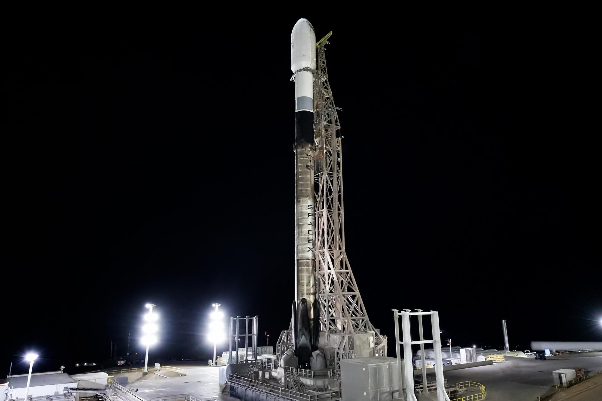
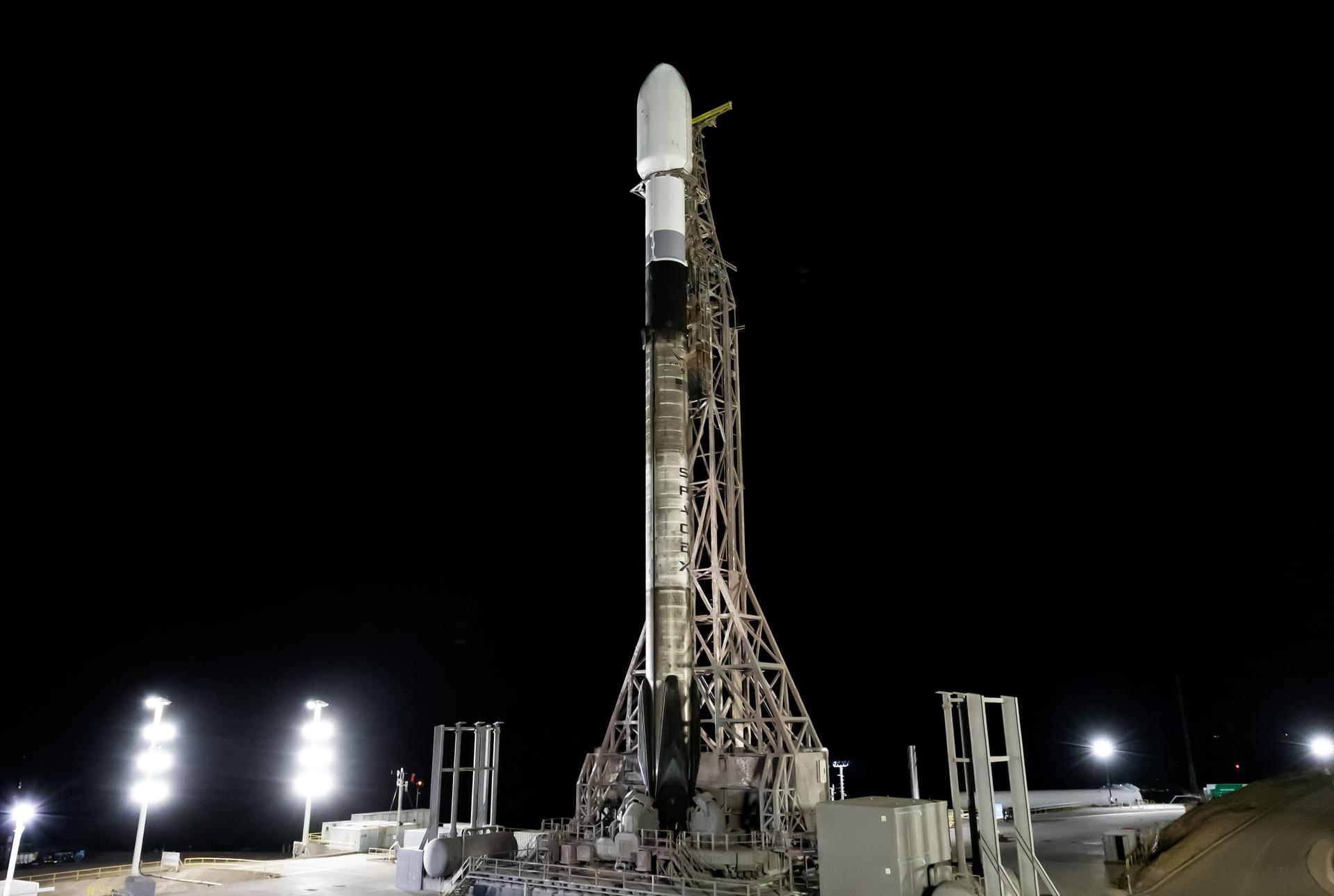
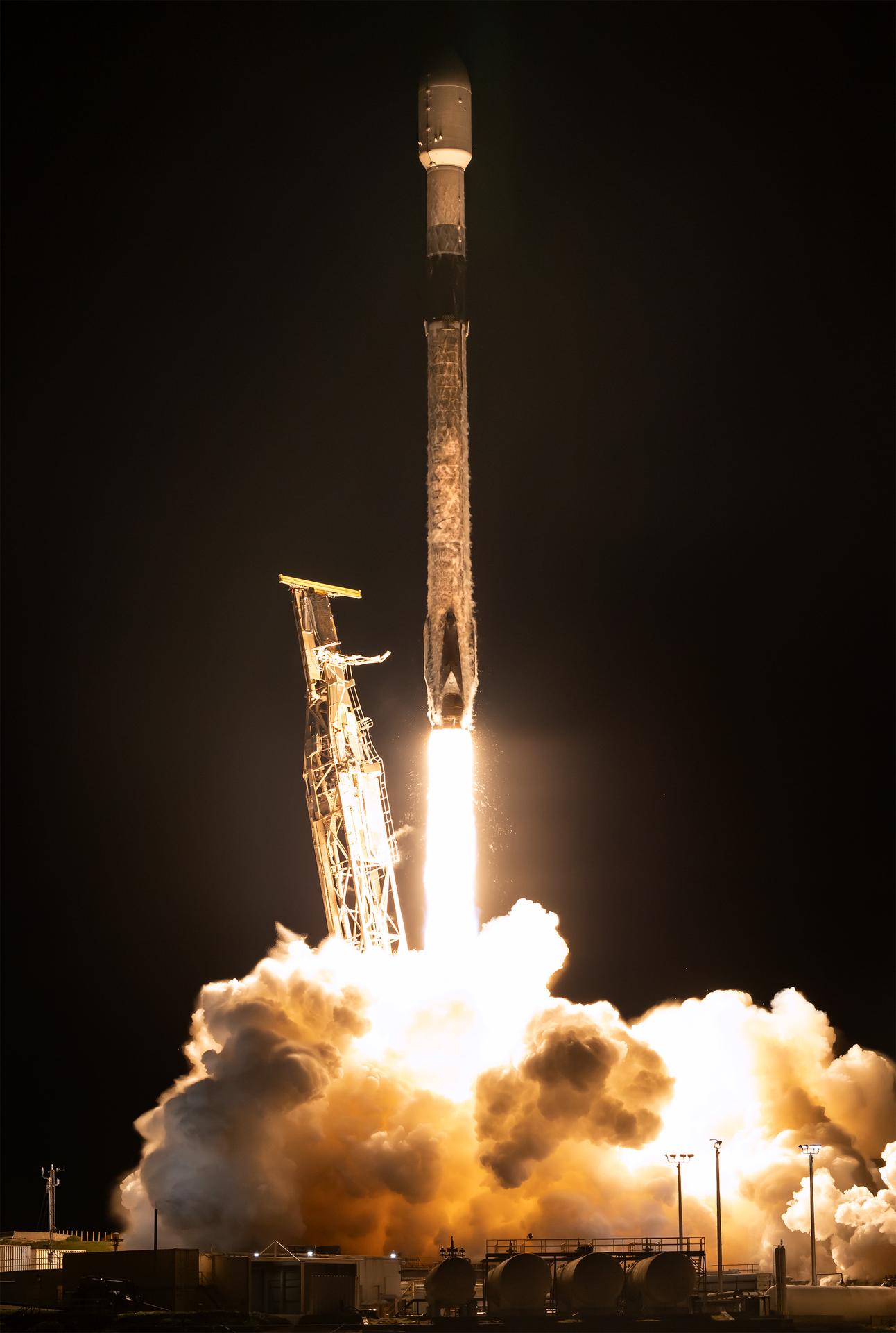
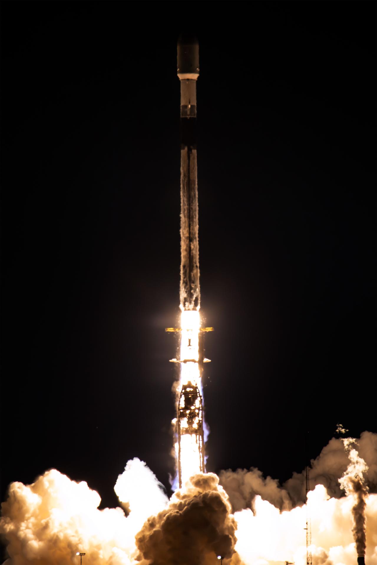
A SpaceX Falcon 9 rocket carrying NASA’s Pandora small satellite, the Star-Planet Activity Research CubeSat (SPARCS), Black Hole Coded Aperture Telescope (BlackCAT) CubeSat, and several other payloads stands vertical on the pad at Space Launch Complex 4 East at Vandenberg Space Force Base in California on Sunday, Jan. 11, 2026, as part of the company’s Twilight mission. Pandora will provide an in-depth study of at least 20 known planets orbiting distant stars to determine the composition of their atmospheres — especially the presence of hazes, clouds, and water. Launch of SpaceX’s Twilight mission is scheduled for 5:44 a.m. PST Jan. 11, from Vandenberg’s Space Launch Complex 4 East.
A SpaceX Falcon 9 rocket carrying NASA’s Pandora small satellite, the Star-Planet Activity Research CubeSat (SPARCS), Black Hole Coded Aperture Telescope (BlackCAT) CubeSat, and several other payloads stands vertical on the pad at Space Launch Complex 4 East at Vandenberg Space Force Base in California on Sunday, Jan. 11, 2026, as part of the company’s Twilight mission. Pandora will provide an in-depth study of at least 20 known planets orbiting distant stars to determine the composition of their atmospheres — especially the presence of hazes, clouds, and water. Launch of SpaceX’s Twilight mission is scheduled for 5:44 a.m. PST Jan. 11, from Vandenberg’s Space Launch Complex 4 East.
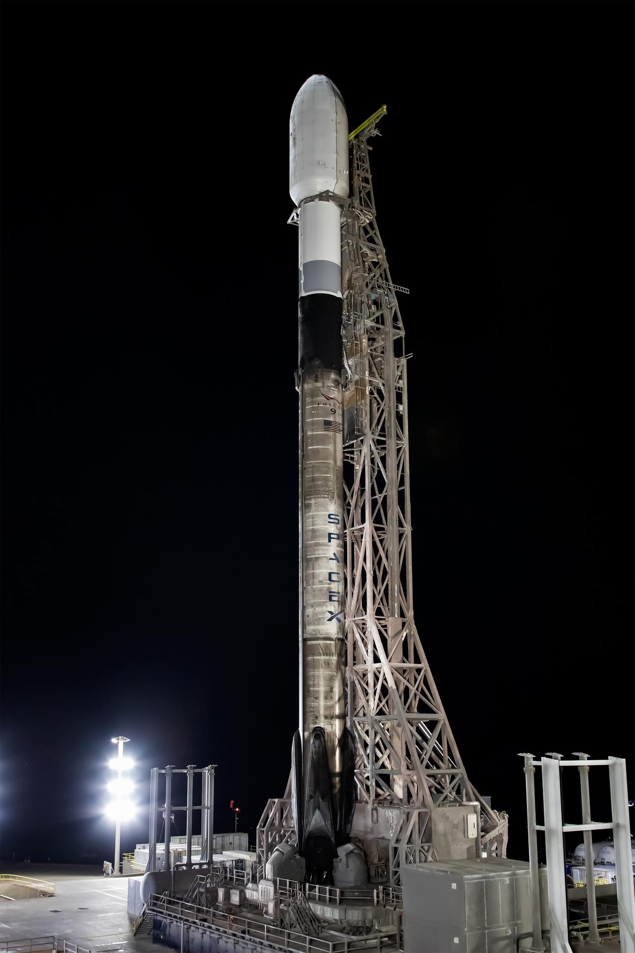
A SpaceX Falcon 9 rocket carrying NASA’s Pandora small satellite, the Star-Planet Activity Research CubeSat (SPARCS), Black Hole Coded Aperture Telescope (BlackCAT) CubeSat, and several other payloads stands vertical on the pad at Space Launch Complex 4 East at Vandenberg Space Force Base in California on Sunday, Jan. 11, 2026, as part of the company’s Twilight mission. Pandora will provide an in-depth study of at least 20 known planets orbiting distant stars to determine the composition of their atmospheres — especially the presence of hazes, clouds, and water. Launch of SpaceX’s Twilight mission is scheduled for 5:44 a.m. PST Jan. 11, from Vandenberg’s Space Launch Complex 4 East.

This view of the twilight sky and Martian horizon taken by NASA Curiosity Mars rover includes Earth as the brightest point of light in the night sky. Earth is a little left of center in the image, and our moon is just below Earth.
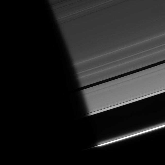
As ring particles emerge from the darkness of Saturn shadow, they pass through a region of twilight. The Sun light, refracted by the planet atmosphere, peeks around the limb, followed shortly by the Sun itself
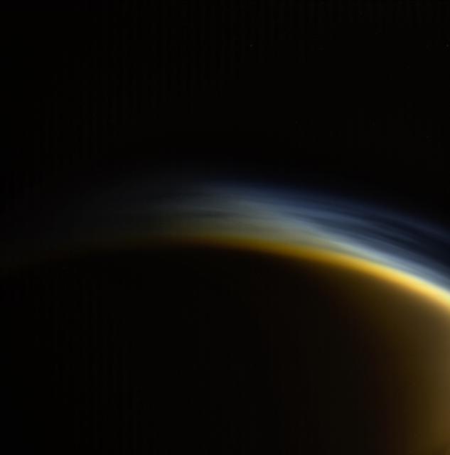
In this view, individual layers of haze can be distinguished in the upper atmosphere of Titan, Saturn's largest moon. Titan's atmosphere features a rich and complex chemistry originating from methane and nitrogen and evolving into complex molecules, eventually forming the smog that surrounds the moon. This natural color image was taken in visible light with the Cassini spacecraft wide-angle camera on March 31, 2005, at a distance of approximately 20,556 miles (33,083 kilometers) from Titan. The view looks toward the north polar region on the moon's night side. Part of Titan's sunlit crescent is visible at right. The Cassini spacecraft ended its mission on Sept. 15, 2017. https://photojournal.jpl.nasa.gov/catalog/PIA21902
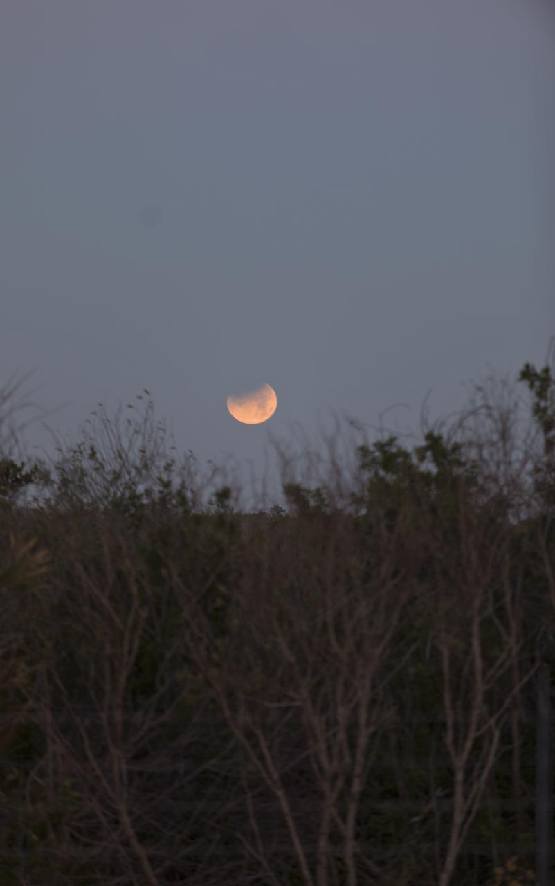
In twilight and framed by native vegetation, the Moon rises over NASA's Kennedy Space Center in Florida.
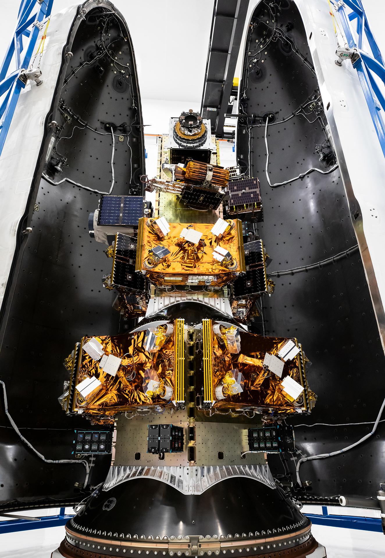
Teams prepare to encapsulate in early January 2026 NASA’s Pandora small satellite, and NASA-sponsored Star-Planet Activity Research CubeSat (SPARCS), and Black Hole Coded Aperture Telescope (BlackCAT) CubeSat, inside a SpaceX Falcon 9 payload fairing along with several other satellites at Vandenberg Space Force Base in California, as part of the company’s Twilight mission. Pandora will provide an in-depth study of at least 20 known planets orbiting distant stars to determine the composition of their atmospheres — especially the presence of hazes, clouds, and water.
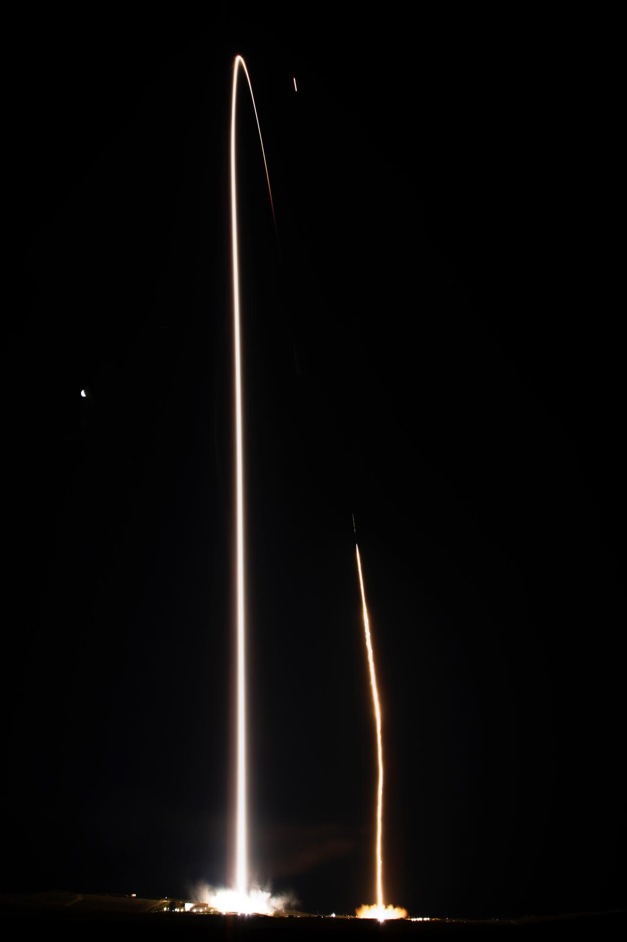
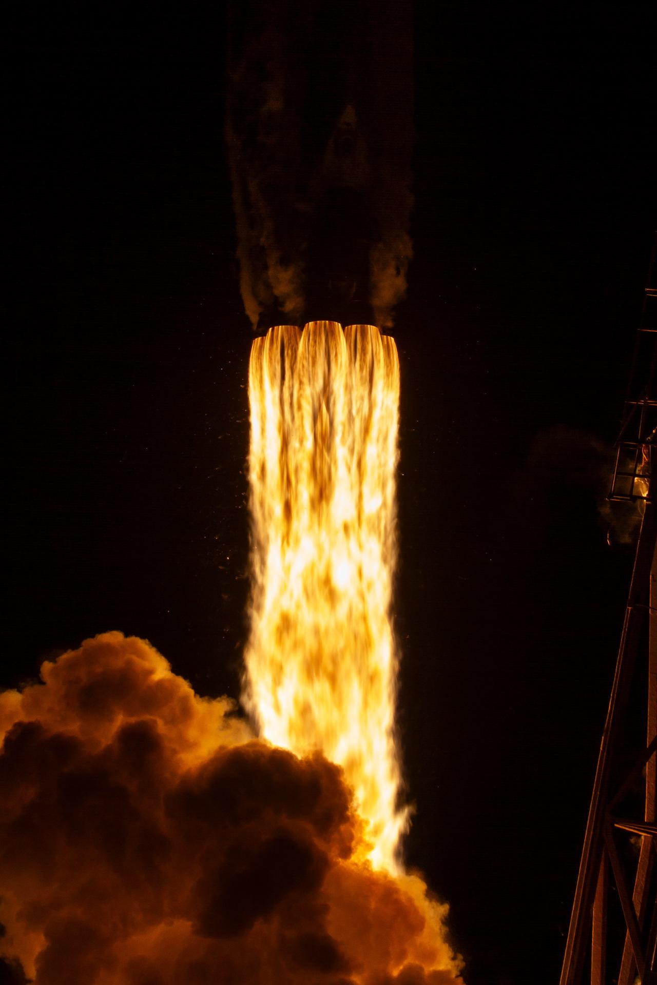
A photo captures the liftoff and landing of a SpaceX Falcon 9 rocket carrying NASA’s Pandora small satellite, the Star-Planet Activity Research CubeSat (SPARCS), and Black Hole Coded Aperture Telescope (BlackCAT) CubeSat from Space Launch Complex 4 East at Vandenberg Space Force Base in California on Sunday, Jan. 11, 2026, as part of the company’s Twilight mission. Pandora will provide an in-depth study of at least 20 known planets orbiting distant stars to determine the composition of their atmospheres — especially the presence of hazes, clouds, and water.

A SpaceX booster prepares for landing following the launch of NASA’s Pandora small satellite, the Star-Planet Activity Research CubeSat (SPARCS), and Black Hole Coded Aperture Telescope (BlackCAT) CubeSat from Space Launch Complex 4 East at Vandenberg Space Force Base in California on Sunday, Jan. 11, 2026, as part of the company’s Twilight mission. Pandora will provide an in-depth study of at least 20 known planets orbiting distant stars to determine the composition of their atmospheres — especially the presence of hazes, clouds, and water.
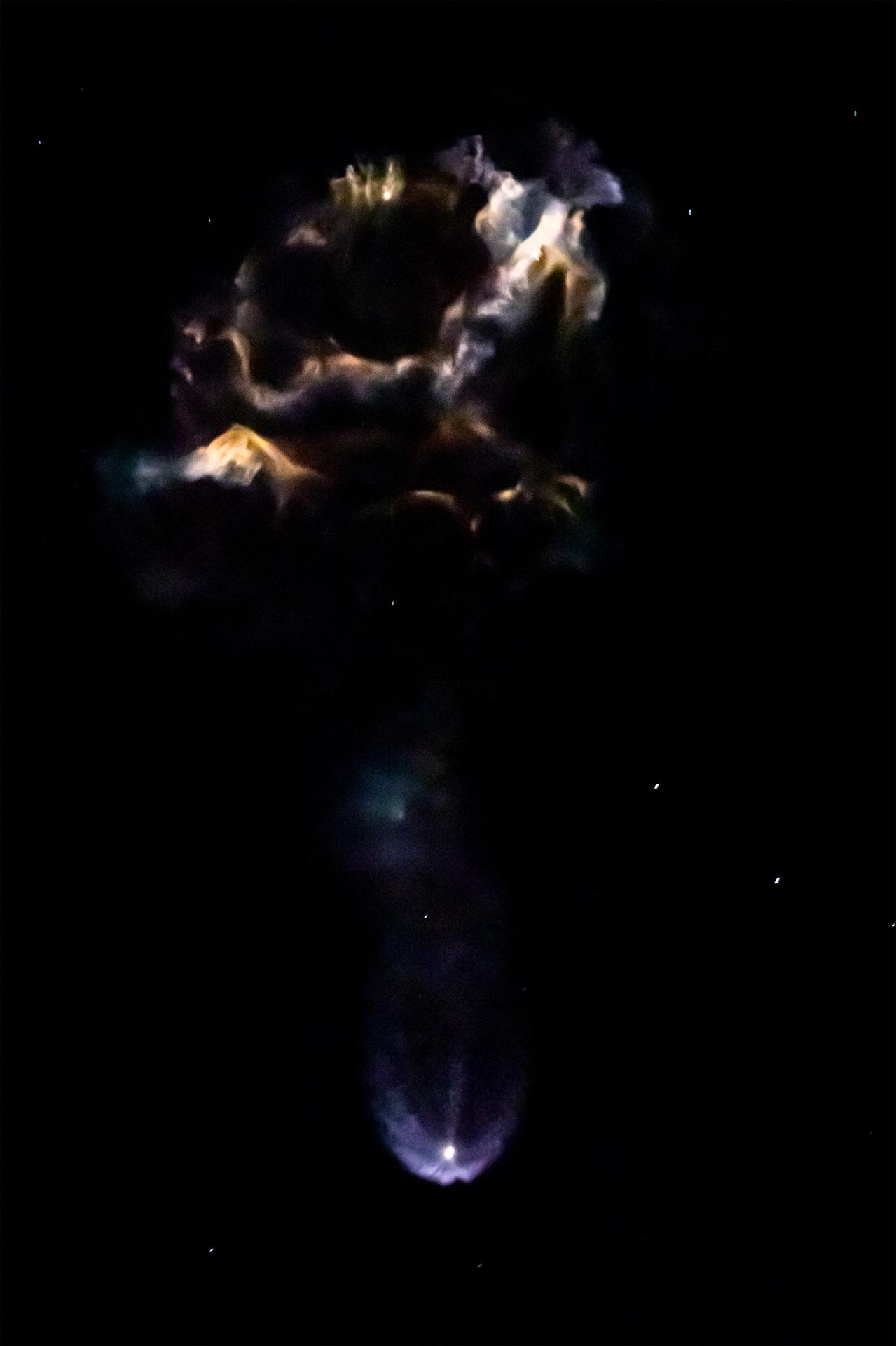
A SpaceX booster returns for landing following the launch of NASA’s Pandora small satellite, the Star-Planet Activity Research CubeSat (SPARCS), and Black Hole Coded Aperture Telescope (BlackCAT) CubeSat from Space Launch Complex 4 East at Vandenberg Space Force Base in California on Sunday, Jan. 11, 2026, as part of the company’s Twilight mission. Pandora will provide an in-depth study of at least 20 known planets orbiting distant stars to determine the composition of their atmospheres — especially the presence of hazes, clouds, and water.

iss065e045974 (May 13, 2021) --- The night lights of Italy are prominent as the International Space Station soared 262 miles above southern Europe during an orbital twilight.

The two bodies in this portion of an evening-sky view by NASA Mars rover Curiosity are Earth and Earth moon. The rover Mast Camera Mastcam imaged them in the twilight sky of Curiosity 529th Martian day, or sol Jan. 31, 2014.

NASA's New Horizons spacecraft took this stunning image of Pluto only a few minutes after closest approach on July 14, 2015. The image was obtained at a high phase angle -- that is, with the sun on the other side of Pluto, as viewed by New Horizons. Seen here, sunlight filters through and illuminates Pluto's complex atmospheric haze layers. The southern portions of the nitrogen ice plains informally named Sputnik Planum, as well as mountains of the informally named Norgay Montes, can also be seen across Pluto's crescent at the top of the image. Looking back at Pluto with images like this gives New Horizons scientists information about Pluto's hazes and surface properties that they can't get from images taken on approach. The image was obtained by New Horizons' Ralph/Multispectral Visual Imaging Camera (MVIC) approximately 13,400 miles (21,550 kilometers) from Pluto, about 19 minutes after New Horizons' closest approach. The image has a resolution of 1,400 feet (430 meters) per pixel. Pluto's diameter is 1,475 miles (2,374 kilometers). The inset at top right in the annotated version shows a detail of Pluto's crescent, including an intriguing bright wisp (near the center) measuring tens of miles across that may be a discreet, low-lying cloud in Pluto's atmosphere; if so, it would be the only one yet identified in New Horizons imagery. This cloud -- if that's what it is -- is visible for the same reason the haze layers are so bright: illumination from the sunlight grazing Pluto's surface at a low angle. Atmospheric models suggest that methane clouds can occasionally form in Pluto's atmosphere. The scene in this inset is 140 miles (230 kilometers) across. The inset at bottom right shows more detail on the night side of Pluto. This terrain can be seen because it is illuminated from behind by hazes that silhouette the of the annotated version limb. The topography here appears quite rugged, and broad valleys and sharp peaks with relief totaling 3 miles (5 kilometers) are apparent. This image, made from closer range, is much better than the lower-resolution images of this same terrain taken several days before closest approach. These silhouetted terrains therefore act as a useful "anchor point," giving New Horizons scientists a rare, detailed glimpse at the lay of the land in this mysterious part of Pluto seen at high resolution only in twilight. The scene in this inset is 460 miles (750 kilometers) wide. http://photojournal.jpl.nasa.gov/catalog/PIA20727

iss065e029349 (May 9, 2021) --- An orbital twilight fades over the city lights of Europe as the International Space Station soared 263 miles above southern France. At upper right, is the docked SpaceX Crew Dragon Endeavour.
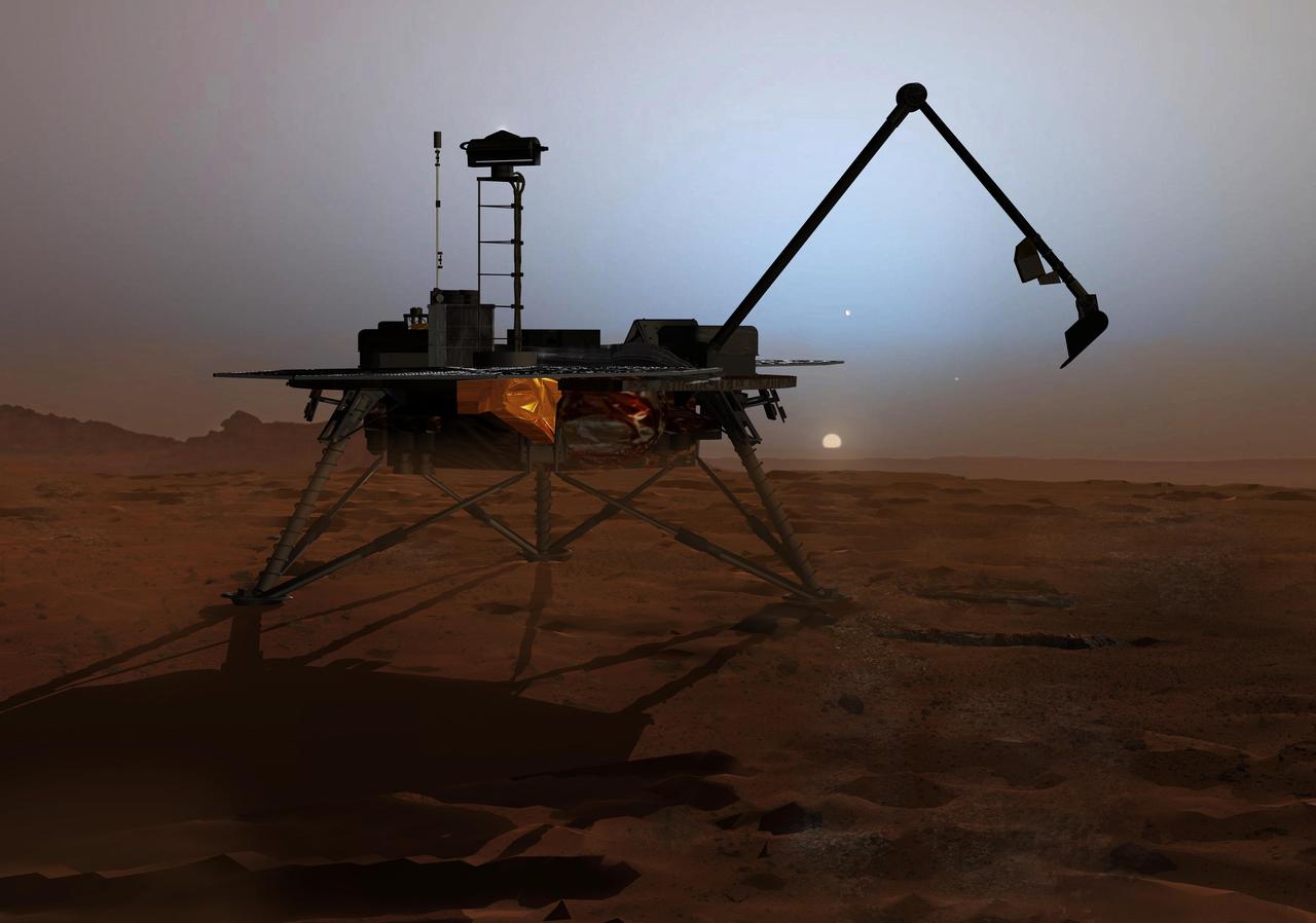
In this artist concept illustration, NASA Phoenix Mars Lander begins to shut down operations as winter sets in. The far-northern latitudes on Mars experience no sunlight during winter.

ISS042E295288 (03/02/2015) --- US Astronaut Terry Virts Flight Engineer of Expedition 42 on the International Space Station tweeted this Earth observation on Mar. 2, 2015 with the comment "The Earth completely changes colors at twilight. It's like a different planet".
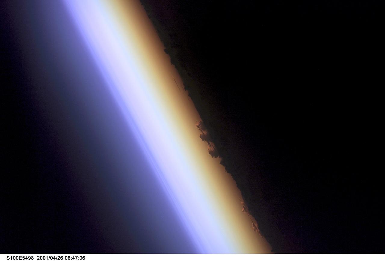
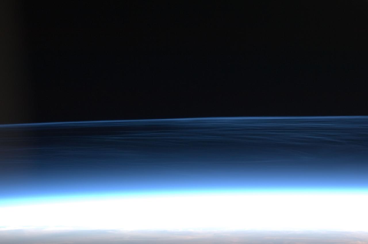
S100-E-5498 (26 April 2001) --- Earth's limb--the edge of the planet seen at twilight--was captured with a digital still camera by one of the STS-100 crew members aboard the Space Shuttle Endeavour. Near center frame the silhouette of cloud layers can be seen in the atmosphere, above which lies an airglow layer (left).
ISS042E230270 (02/06/2015) --- US NASA astronaut Terry Virts, Expedition 42 flight engineer on the International Space Station tweeted this Earth observation on Feb. 6, 2015 and made this comment: " Looking back over middle America at twilight. I love the sun’s reflection off these rivers and lakes".
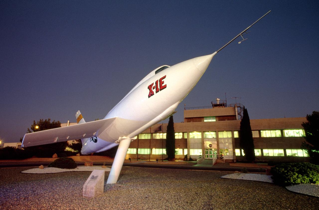
The X-1E guards NASA Dryden Flight Research Center's main building.
ISS031-E-83789 (2 June 2012) --- Downlinked from the International Space Station this still image – part of a series from a mounted, automated, twilight session -- when viewed in sequence shows the flame ring associated with wild fires in the Southwest move from bottom to top-center framed at a distance by the bright urban areas of Tucson, Phoenix, El Paso-Las Cruces, and finally Albuquerque (mostly under cloud).

The Soyuz launch pad is seen in the twilight hour before the Soyuz TM-10 is rolled out by train, Tuesday, Oct. 9, 2018 at the Baikonur Cosmodrome in Kazakhstan. Expedition 57 crewmembers Nick Hague of NASA and Alexey Ovchinin of Roscosmos are scheduled to launch on October 11 and will spend the next six months living and working aboard the International Space Station. Photo Credit: (NASA/Bill Ingalls)
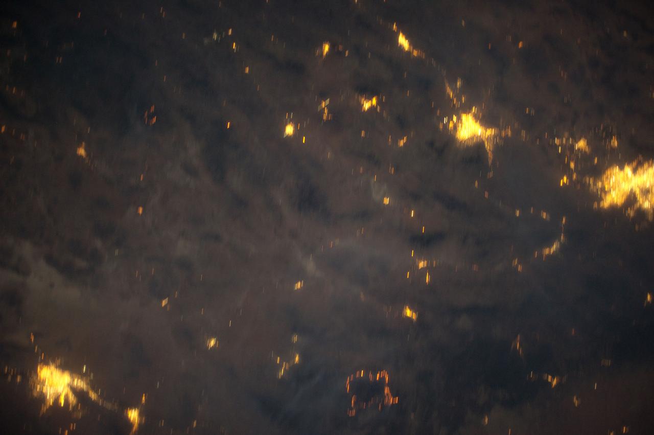
ISS031-E-83747 (2 June 2012) --- Downlinked from the International Space Station this still image -– part of a series from a mounted, automated, twilight session -- when viewed in sequence shows the flame ring associated with wild fires in the Southwest move from bottom to top-center framed at a distance by the bright urban areas of Tucson, Phoenix, El Paso-Las Cruces, and finally Albuquerque (mostly under cloud).

This 1970 photograph shows Skylab's Ultraviolet (UV) Airglow Horizon Photography experiment. It was an astrophysics investigation designed to photograph the twilight airflow and Earth's ozone layer simultaneously in visible and UV wavelengths. These observations provided information on oxygen, nitrogen, and ozone layers in the Earth's atmosphere, and on their variation during night and day cycles. The Marshall Space Flight Center had program management responsibility for the development of Skylab hardware and experiments.
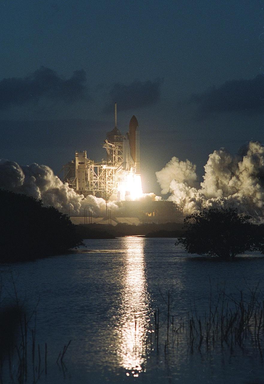
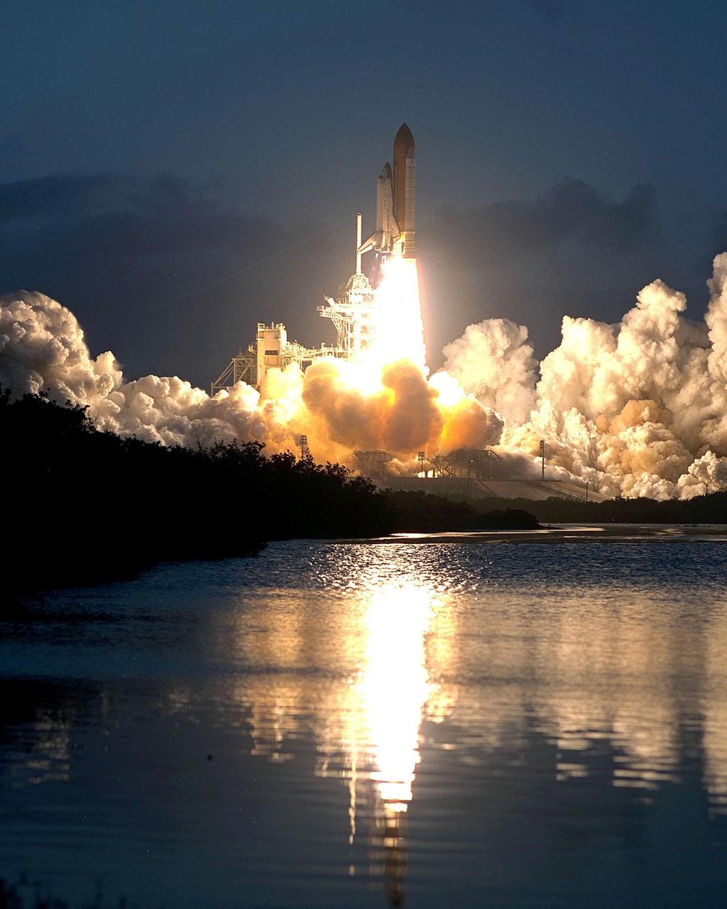
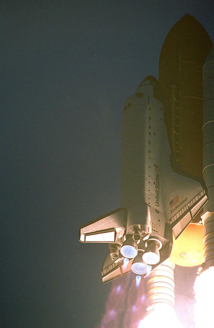
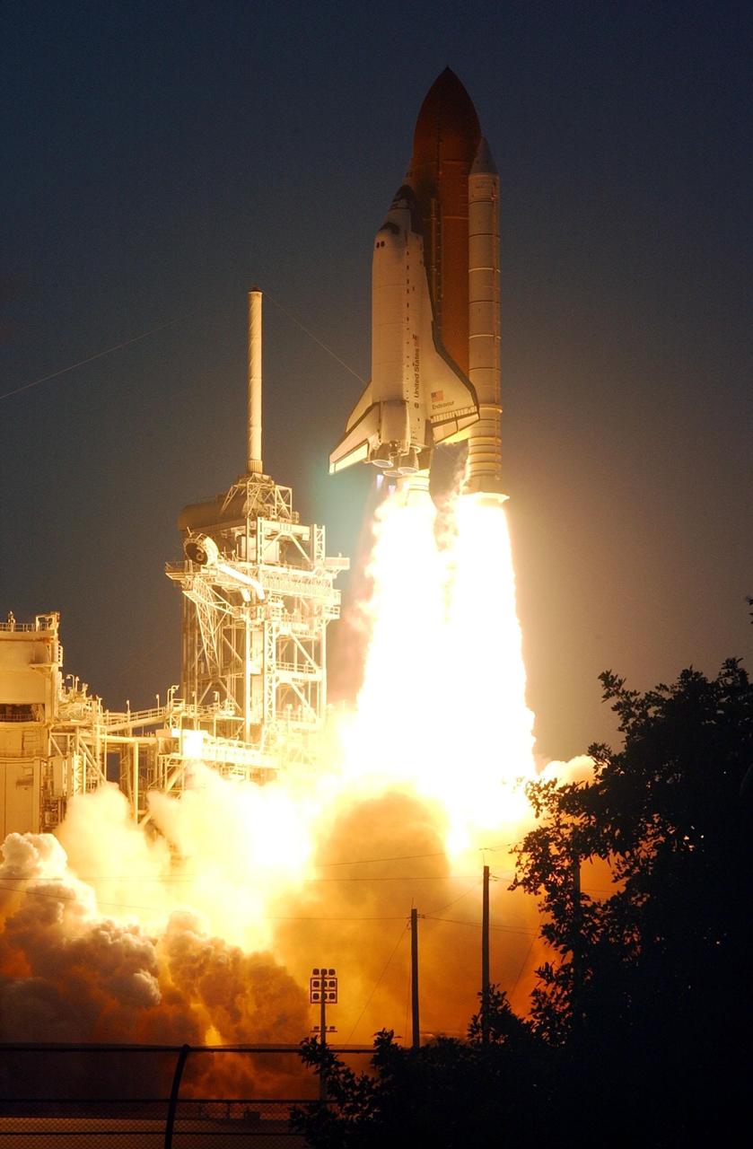
KENNEDY SPACE CENTER, Fla. - The reflection in water near Launch Pad 39B captures the brilliance of the flames trailing Space Shuttle Endeavour as it soars into the twilight sky on mission STS-108. Liftoff occurred at 5:19:28 p.m. EST (22:19 GMT) on this second launch attempt in two days. Endeavour will dock with the International Space Station on Dec. 7. STS-108 is the final Shuttle mission of 2001and the 107th Shuttle flight overall. It is the 12th flight to the Space Station. Landing of the orbiter at KSC's Shuttle Landing Facility is targeted for 1:05 p.m. EST (18:05 p.m. GMT) Dec. 16
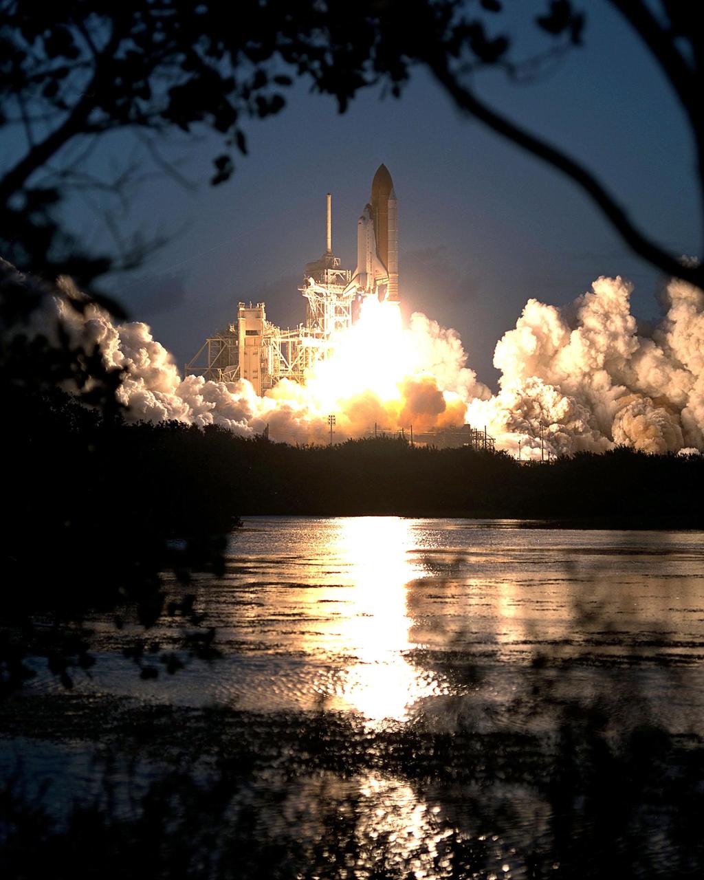
KENNEDY SPACE CENTER, Fla. -- Space Shuttle Endeavour soars into a twilight sky on mission STS-108, the second launch attempt over two days. Liftoff occurred at 5:19:28 p.m. EST (22:19.28 GMT). Endeavour will dock with the International Space Station on Dec. 7. STS-108 is the final Shuttle mission of 2001and the 107th Shuttle flight overall. It is the 12th flight to the Space Station. Landing of the orbiter at KSC's Shuttle Landing Facility is targeted for 1:05 p.m. EST (18:05 p.m. GMT) Dec. 16

KENNEDY SPACE CENTER, Fla. -- Space Shuttle Endeavour soars into a twilight sky on mission STS-108, the second launch attempt over two days. Liftoff occurred at 5:19:28 p.m. EST (22:19.28 GMT). Endeavour will dock with the International Space Station on Dec. 7. STS-108 is the final Shuttle mission of 2001and the 107th Shuttle flight overall. It is the 12th flight to the Space Station. Landing of the orbiter at KSC's Shuttle Landing Facility is targeted for 1:05 p.m. EST (18:05 p.m. GMT) Dec. 16

KENNEDY SPACE CENTER, Fla. -- Spewing flames and smoke, Space Shuttle Endeavour hurtles into the twilight sky on mission STS-108. The second attempt in two days, liftoff occurred at 5:19:28 p.m. EST (22:19 GMT). Endeavour will dock with the International Space Station on Dec. 7. STS-108 is the final Shuttle mission of 2001and the 107th Shuttle flight overall. It is the 12th flight to the Space Station. Landing of the orbiter at KSC's Shuttle Landing Facility is targeted for 1:05 p.m. EST (18:05 p.m. GMT) Dec. 16

KENNEDY SPACE CENTER, Fla. -- Space Shuttle Endeavour soars into a twilight sky on mission STS-108, the second launch attempt over two days. Liftoff occurred at 5:19:28 p.m. EST (22:19.28 GMT). Endeavour will dock with the International Space Station on Dec. 7. STS-108 is the final Shuttle mission of 2001and the 107th Shuttle flight overall. It is the 12th flight to the Space Station. Landing of the orbiter at KSC's Shuttle Landing Facility is targeted for 1:05 p.m. EST (18:05 p.m. GMT) Dec. 16
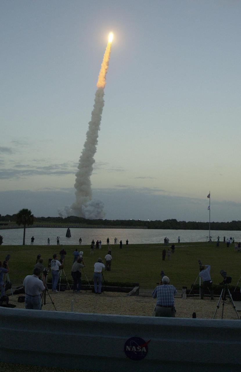
KENNEDY SPACE CENTER, Fla. -- Space Shuttle Endeavour soars into a twilight sky on mission STS-108, the second attempt over two days. Liftoff occurred at 5:19:28 p.m. EST (22:19 GMT). Endeavour will dock with the International Space Station on Dec. 7. STS-108 is the final Shuttle mission of 2001and the 107th Shuttle flight overall. It is the 12th flight to the Space Station. Landing of the orbiter at KSC's Shuttle Landing Facility is targeted for 1:05 p.m. EST (18:05 p.m. GMT) Dec. 16
KENNEDY SPACE CENTER, Fla. -- Space Shuttle Endeavour soars into a twilight sky on mission STS-108, the second launch attempt over two days. Liftoff occurred at 5:19:28 p.m. EST (22:19.28 GMT). Endeavour will dock with the International Space Station on Dec. 7. STS-108 is the final Shuttle mission of 2001and the 107th Shuttle flight overall. It is the 12th flight to the Space Station. Landing of the orbiter at KSC's Shuttle Landing Facility is targeted for 1:05 p.m. EST (18:05 p.m. GMT) Dec. 16
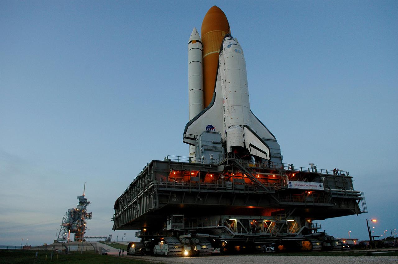
KENNEDY SPACE CENTER, FLA. - In the waning twilight, the service structures on Launch Pad 39B (left) and the Mobile Launcher Platform carrying Space Shuttle Discovery glow with lights. The Shuttle began rollout to the pad at 2:04 p.m. EDT from the Vehicle Assembly Building at NASA’s Kennedy Space Center, marking a major milestone in the Space Shuttle Program’s Return to Flight. Launch of Discovery on its Return to Flight mission, STS-114, is targeted for May 15 with a launch window that extends to June 3. During its 12-day mission, Discovery’s seven-person crew will test new hardware and techniques to improve Shuttle safety, as well as deliver supplies to the International Space Station.
KENNEDY SPACE CENTER, Fla. -- Space Shuttle Endeavour soars into a twilight sky on mission STS-108, the second attempt over two days. Liftoff occurred at 5:19:28 p.m. EST (22:19 GMT). Endeavour will dock with the International Space Station on Dec. 7. STS-108 is the final Shuttle mission of 2001and the 107th Shuttle flight overall. It is the 12th flight to the Space Station. Landing of the orbiter at KSC's Shuttle Landing Facility is targeted for 1:05 p.m. EST (18:05 p.m. GMT) Dec. 16

Backdropped by a twilight sky, Northrop Grumman's L-1011 Stargazer undergoes final preparations prior to its takeoff from Vandenberg Air Force Base in California on Oct. 1, 2019. The company's Pegasus XL rocket, containing NASA's Ionospheric Connection Explorer (ICON), is attached beneath the aircraft. The explorer is targeted to launch on Oct. 9, 2019, from Cape Canaveral Air Force Station in Florida. ICON will study the frontier of space - the dynamic zone high in Earth's atmosphere where terrestrial weather from below meets space weather above.

KENNEDY SPACE CENTER, Fla. -- Space Shuttle Endeavour soars into a twilight sky on mission STS-108, the second attempt over two days. Liftoff occurred at 5:19:28 p.m. EST (22:19 GMT). Endeavour will dock with the International Space Station on Dec. 7. STS-108 is the final Shuttle mission of 2001and the 107th Shuttle flight overall. It is the 12th flight to the Space Station. Landing of the orbiter at KSC's Shuttle Landing Facility is targeted for 1:05 p.m. EST (18:05 p.m. GMT) Dec. 16
KENNEDY SPACE CENTER, Fla. -- Spewing flames and smoke, Space Shuttle Endeavour hurtles into the twilight sky on mission STS-108. The second attempt in two days, liftoff occurred at 5:19:28 p.m. EST (22:19 GMT). Endeavour will dock with the International Space Station on Dec. 7. STS-108 is the final Shuttle mission of 2001and the 107th Shuttle flight overall. It is the 12th flight to the Space Station. Landing of the orbiter at KSC's Shuttle Landing Facility is targeted for 1:05 p.m. EST (18:05 p.m. GMT) Dec. 16
This image was taken by the Imager for Mars Pathfinder (IMP) about one minute after sunset on Mars on Sol 21. The prominent hills dubbed "Twin Peaks" form a dark silhouette at the horizon, while the setting sun casts a pink glow over the darkening sky. The image was taken as part of a twilight study which indicates how the brightness of the sky fades with time after sunset. Scientists found that the sky stays bright for up to two hours after sunset, indicating that Martian dust extends very high into the atmosphere. http://photojournal.jpl.nasa.gov/catalog/PIA00783
The one-inch mirror shown here is one of nearly nine hundred polished by dozens of students teams of elementary, middle and high school students across the nation as part of STARSHINE, a student spacecraft built by the Naval Research Laboratory in Washington, D.C. After being coated with a protective transparent layer of Silicon Dioxide at Hill Air Force Base, they are being mounted on the surface of the spacecraft. STARSHINE is being deployed into a highly inclined low-earth orbit from a Hitchhiker canister on mission STS-96, targeted to launch May 20. After deployment from the Shuttle in May, the spacecraft will reflect flashes of sunlight to observers on the earth during the mission. This twinkling satellite will be naked-eye visible against the star background for about six months during recurring morning and evening twilight periods to student observers around the world
KENNEDY SPACE CENTER, FLA. - Space Shuttle Discovery lingers at the foot of Launch Pad 39B in the evening twilight. First motion from the Vehicle Assembly Building was at 2:04 p.m. EDT April 6, and the Shuttle was hard down on the pad at 1:16 a.m. EDT April 7. The Shuttle sits atop a Mobile Launcher Platform transported by a Crawler-Transporter underneath. Launch of Discovery on its Return to Flight mission, STS-114, is targeted for May 15 with a launch window that extends to June 3. During its 12-day mission, Discovery’s seven-member crew will test new hardware and techniques to improve Shuttle safety, as well as deliver supplies to the International Space Station. Photo courtesy of Scott Andrews.
NASA's Curiosity Mars rover captured these "sun rays" shining through clouds at sunset on Feb. 2, 2023, the 3,730th Martian day, or sol, of the mission. It was the first time that sun rays, also known as crepuscular rays, have been viewed so clearly on Mars. Crepuscular is taken from the Latin word for "twilight," as these rays appear near sunset or sunrise. These clouds were captured as part of a follow-on imaging campaign to study noctilucent, or "night-shining" clouds, which started in 2021. While most Martian clouds hover no more than 37 miles (60 kilometers) above the ground and are composed of water ice, these clouds appear to be higher in elevation, where it's very cold. That suggests these clouds are made of carbon dioxide, or dry ice. This scene made up of 28 individual images captured by the rover's Mast Camera, or Mastcam. The images have been processed to emphasize the highlights. https://photojournal.jpl.nasa.gov/catalog/PIA25739
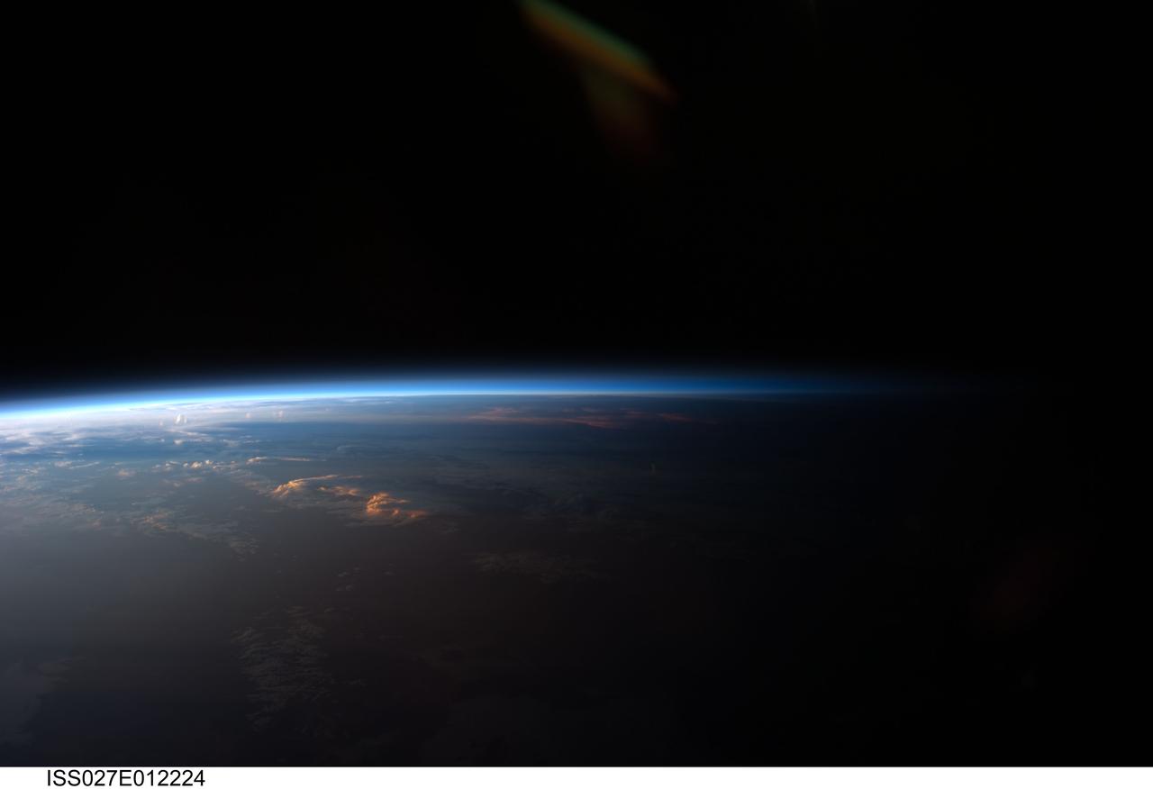
ISS027-E-012224 (12 April 2011) --- Sunset over western South America is featured in this image photographed by an Expedition 27 crew member on the International Space Station. Crew members onboard the space station see, on average, sixteen sunrises and sunsets during a 24-hour orbital period. Each changeover between day and night on the ground is marked by the terminator, or line separating the sunlit side of Earth from the side in darkness. While the terminator is conceptualized as a hard boundary?and is frequently presented as such in graphics and visualizations?in reality the boundary between light and dark is diffuse due to scattering of light by Earth?s atmosphere. This zone of diffuse lighting is experienced as dusk or twilight on the ground ? while the sun is no longer visible, some illumination is still present due to light scattering over the local horizon. The terminator is visible in this photograph trending across the image from lower left to upper right. This panoramic view across central South America, looking towards the northeast, was acquired at approximately 7:37 p.m. local time. Layers of Earth?s atmosphere, colored bright white to deep blue, are visible extending across the horizon (or limb). The highest cloud tops have a reddish glow from the direct light of the setting sun while lower clouds are in twilight. The Salar de Coipasa, a large salt lake in Bolivia, is dimly visible on the night side of the terminator. The salar provides a geographic reference point that allows the location and viewing orientation of the image to be determined.

ISS024-E-006136 (16 June 2010) --- Polar mesospheric clouds, illuminated by an orbital sunrise, are featured in this image photographed by an Expedition 24 crew member on the International Space Station. Polar mesospheric, or noctilucent (?night shining?), clouds are observed from both Earth?s surface and in orbit by crew members aboard the space station. They are called night-shining clouds as they are usually seen at twilight. Following the setting of the sun below the horizon and darkening of Earth?s surface, these high clouds are still briefly illuminated by sunlight. Occasionally the ISS orbital track becomes nearly parallel to Earth?s day/night terminator for a time, allowing polar mesospheric clouds to be visible to the crew at times other than the usual twilight due to the space station altitude. This unusual photograph shows polar mesospheric clouds illuminated by the rising, rather than setting, sun at center right. Low clouds on the horizon appear yellow and orange, while higher clouds and aerosols are illuminated a brilliant white. Polar mesospheric clouds appear as light blue ribbons extending across the top of the image. These clouds typically occur at high latitudes of both the Northern and Southern Hemispheres, and at fairly high altitudes of 76?85 kilometers (near the boundary between the mesosphere and thermosphere atmospheric layers). The ISS was located over the Greek island of Kos in the Aegean Sea (near the southwestern coastline of Turkey) when the image was taken at approximately midnight local time. The orbital complex was tracking northeastward, nearly parallel to the terminator, making it possible to observe an apparent ?sunrise? located almost due north. A similar unusual alignment of the ISS orbit track, terminator position, and seasonal position of Earth?s orbit around the sun allowed for striking imagery of polar mesospheric clouds over the Southern Hemisphere earlier this year.

Students Scott Kerley and Bryan Geer demonstrate how they polished mirrors for STARSHINE, a student spacecraft built by the Naval Research Laboratory in Washington, D.C. The two seventh graders at McNair Magnet School, Cocoa Beach, Fla., are among dozens of students teams of elementary, middle and high school students who have polished nearly nine hundred of the one-inch mirrors and returned them to Utah for coating with a protective transparent layer of Silicon Dioxide at Hill Air Force Base. The mirrors are being mounted on the surface of the spacecraft. STARSHINE is being deployed into a highly inclined low-earth orbit from a Hitchhiker canister on mission STS-96, targeted to launch May 20. After deployment from the Shuttle in May, the spacecraft will reflect flashes of sunlight to observers on the earth during the mission. This twinkling satellite will be naked-eye visible against the star background for about six months during recurring morning and evening twilight periods to student observers around the world
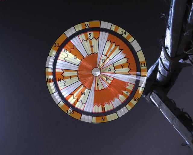
This annotated image was taken by a parachute-up-look camera aboard the protective back shell of NASA's Perseverance rover during its descent toward Mars' Jezero Crater on February 18, 2021. Using binary code, two messages have been encoded in the neutral white and international-orange parachute gores (the sections that make up the canopy's hemispherical shape). The inner portion spells out "DARE MIGHTY THINGS," with each word located on its own ring of gores. The outer band of the canopy provides GPS coordinates for NASA's Jet Propulsion Laboratory in Southern California, where the rover was built and the project is managed. Mars 2020 Perseverance Systems Engineer Ian Clark designed the binary code pattern. The saying is JPL's motto and is an abridgement of a quote from Teddy Roosevelt's "Strenuous Life" speech: "Far better is it to dare mighty things, to win glorious triumphs, even though checkered by failure ... than to rank with those poor spirits who neither enjoy nor suffer much, because they live in a gray twilight that knows not victory nor defeat." https://photojournal.jpl.nasa.gov/catalog/PIA24431

Every several days, Mars Pathfinder will image the sunrise and sunset on Mars. Future images will show a larger area -- we have a higher data rate than we expected when we planned this image, so we can get more information. Images taken at sunset, like this, and up to two hours later, will be used to investigate the distribution of dust within the Martian atmosphere. Already, we can see some dust layers in the images. By seeing how the twilight fades with time -- it lasts for over two hours -- we can determine that the dust extends high into the atmosphere. Sojourner spent 83 days of a planned seven-day mission exploring the Martian terrain, acquiring images, and taking chemical, atmospheric and other measurements. The final data transmission received from Pathfinder was at 10:23 UTC on September 27, 1997. Although mission managers tried to restore full communications during the following five months, the successful mission was terminated on March 10, 1998. http://photojournal.jpl.nasa.gov/catalog/PIA00696
ISS028-E-020276 (2 Aug. 2011) --- This photograph of polar mesospheric clouds was acquired at an altitude of just over 202 nautical miles (about 322 kilometers) in the evening hours (03:19:54 Greenwich Mean Time) on Aug. 2, 2011, as the International Space Station was passing over the English Channel. The nadir coordinates of the station were 49.1 degrees north latitude and 5.5 degrees west longitude. Polar mesospheric clouds (also known as noctilucent, or ?night-shining? clouds) are transient, upper atmospheric phenomena that are usually observed in the summer months at high latitudes (greater than 50 degrees) of both the Northern and Southern Hemispheres. They appear bright and cloudlike while in deep twilight. They are illuminated by sunlight when the lower layers of the atmosphere are in the darkness of Earth?s shadow. The horizon of Earth appears at the bottom of the image, with some layers of the lower atmosphere already illuminated by the rising sun. The higher, bluish-colored clouds look much like wispy cirrus clouds, which can be found as high as 60,000 feet (18 kilometers) in the atmosphere. However noctilucent clouds, as seen here, are observed in the mesosphere at altitudes of 250,000 to 280,000 feet (about 76 to 85 kilometers). Astronaut observations of polar mesospheric clouds over northern Europe in the summer are not uncommon.

ISS031-E-116058 (13 June 2012) --- Polar mesospheric clouds in the Northern Hemisphere are featured in this image photographed by an Expedition 31 crew member on the International Space Station. In both the Northern and Southern Hemisphere, during their respective late spring and early summer seasons, polar mesospheric clouds are at the peak of their visibility. Visible from the ground during twilight, aircraft in flight, and the International Space Station, they typically appear as delicate shining threads against the darkness of space?hence their other name of noctilucent or ?night-shining? clouds. On the same day this image was taken from the space station while it was passing over the night-darkened Tibetan Plateau, polar mesospheric clouds were also visible to aircraft flying above Canada. In addition to this still image, the space station crew took a time-lapse image sequence of polar mesospheric clouds several days earlier (June 5, 2012) while passing over western Asia; this is first such sequence of images of the phenomena taken from orbit. Polar mesospheric clouds form between 76-85 kilometers above the Earth?s surface, when there is sufficient water vapor at these high altitudes to freeze into ice crystals. The clouds are illuminated by the setting sun while the ground surface below is in darkness, lending them their night-shining properties. In addition to the illuminated tracery of polar mesospheric clouds trending across the center of the image, lower layers of the atmosphere are also illuminated; the lowest layer of the atmosphere, the stratosphere, is indicated by dim orange and red tones. While the exact cause of formation of polar mesospheric clouds is still debated?dust from meteors, global warming, and rocket exhaust have all been suggested as contributing factors?recent research suggests that changes in atmospheric gas composition or temperature has caused the clouds to become brighter over time.
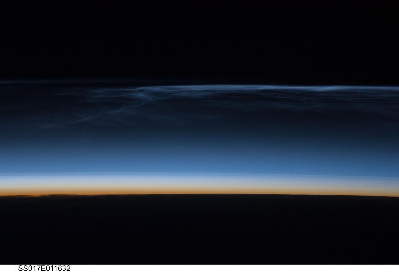
ISS017-E-011632 (22 July 2008) --- Polar Mesospheric Clouds (also known as noctilucent clouds) are transient, upper atmospheric phenomena observed usually in the summer months at high latitudes (greater than 50 degrees) of both the Northern and Southern Hemispheres. They are bright and cloudlike in appearance while in deep twilight. They are illuminated by sunlight when the lower layers of the atmosphere are in the darkness of the Earth's shadow. This image was acquired at an altitude of just over 200 miles in the pre-dawn hours of July 22, 2008 as the International Space Station was passing over western Mongolia in central Asia. The dark horizon of the Earth appears below with some layers of the lower atmosphere already illuminated. The higher, bluish-colored clouds look much like wispy cirrus clouds which can be found in the troposphere as high as 60,000 feet. However noctilucent clouds, as seen here, are observed in the mesosphere at altitudes of 250,000 to 280,000 feet. Astronaut observations of Polar Mesospheric Clouds (PMC) over northern Asia in June and July are not uncommon. The Expedition 17 crew of the International Space Station acquired this image, and more, in support of research for the International Polar Year. Some researchers link increased observations of PMC to changes in global climate; PMC have been the subject of extensive observation and research from space by the Swedish satellite Odin launched in 2001 and more recently by NASA's Aeronomy of Ice in the Mesosphere (AIM) satellite system beginning in 2007.
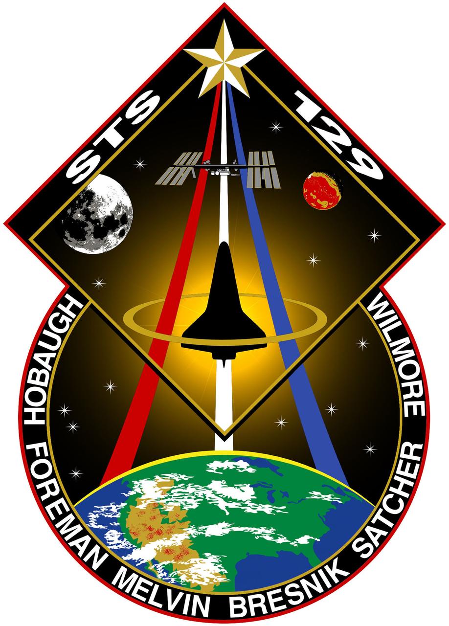
JOHNSON SPACE CENTER, Houston - STS129-S-001 -- For STS-129 the sun shines brightly on the International Space Station (ISS) above and the United States below representing the bright future of U.S. human spaceflight. The contiguous U.S., Rocky Mountains, and Great Desert Southwest are clearly visible on the earth below encompassing all the NASA centers and the homes of the many dedicated people that work to make our Space Program possible. The integrated shapes of the patch signifying the two Express Logistics Carriers that will be delivered by STS-129 providing valuable equipment ensuring the longevity of the ISS. The Space Shuttle is vividly silhouetted by the sun highlighting how brightly the Orbiters have performed as a workhorse for the U.S. Space Program over the past 3 decades. The Space Shuttle ascends on the Astronaut symbol portrayed by the Red, White and Blue swoosh bounded by the gold halo. This symbol is worn with pride by this U.S. crew representing their country on STS-129. The names of the crew members are denoted on the outer band of the patch. As STS-129 launches, the Space Shuttle is in its twilight years. This fact is juxtaposed by the 13 stars on the patch which are symbolic of our children who are the future. The Moon and Mars feature predominantly to represent just how close humankind is to reaching further exploration of those heavenly bodies and how the current Space Shuttle and ISS missions are laying the essential ground work for those future endeavors. The NASA insignia for design for Shuttle flights is reserved for use by the astronauts and for other official use as the NASA Administrator may authorize. Public availability has been approved only in the form of illustrations by the various news media. When and if there is any change in this policy which is not anticipated, it will be publicly announced. (Note: the description is provided by the crew members).
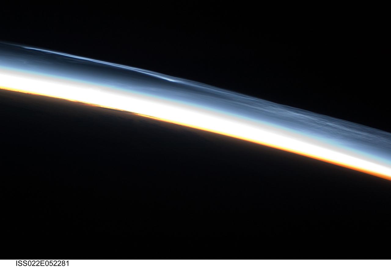
ISS022-E-052281 (30 Jan. 2010) --- Polar mesospheric clouds over the Southern Hemisphere are featured in this image photographed by an Expedition 22 crew member on the International Space Station. This striking view shows polar mesospheric clouds (PMC) over the polar region of the Southern Hemisphere. These clouds occur over the high latitudes of both northern and southern hemispheres during their respective summer months at very high altitudes of approximately 76?85 kilometers. When present they are visible during twilight, when the clouds are illuminated by the sun while the ground surface below is in darkness. The International Space Station (ISS) orbit extends from latitude 52 North to latitude 52 South; combined with the highly oblique views through Earth?s atmosphere possible with hand-held imagery, the ISS is an ideal platform for documenting these transient, high altitude phenomena. Another NASA mission, the Aeronomy of Ice in the Mesosphere or AIM satellite, is dedicated to the study of PMC and is providing daily information about their formation, distribution, and variability. Polar mesospheric clouds are also known as noctilucent or night-shining clouds ? a property that is clearly visible in this photograph. The PMC exhibit thin, wispy light blue forms that contrast with the darkness of space above (upper right). Lower levels of cloud are strongly illuminated by the sun and appear light orange to white. Clouds closest to Earth?s surface are reddish-orange (center). The image was taken approximately 38 minutes after midnight Greenwich Mean Time (GMT) while the ISS was located over the southern Atlantic Ocean. At this time of year, the sun never sets over Antarctica but rather defines an arc across the local horizon, allowing PMC to be observed near local midnight.

In this photograph, Vince Huegele of the Marshall Space Flight Center's (MSFC's) Space Optics Manufacturing Technology Center (SOMTC) inspects the coating on the mirrors for Starshine 3, a satellite that resembles a high-tech disco ball that was placed into Earth orbit. The sphere, which is covered by hundreds of quarter-sized mirrors that reflect sunlight to observers on the ground, helps students study the effects of solar activity on the Earth's atmosphere. Ed White Middle School in Huntsville, Alabama is among 500 schools worldwide whose students helped grind and polish mirrors for the Starshine 3 satellite as a part of the Starshine Project. The total of up to 1,500 mirrors will improve the sunlight flash rate and make the satellite more visible at twilight as it orbits the Earth. These mirrors have been coated with a scratch-resistant, anti-oxidizing layer of silicon dioxide by optical engineers and technicians at the Hill Air Force Base in Utah and MSFC. Starshine-3 was launched on an Athena I unmarned launch vehicle out of the Kodiak Launch Complex, Alaska, on September 29, 2001. Starshine 3 is nearly 37 inches (1 meter) in diameter, weighs 200 pounds (91 kilograms), and carries 1500 mirrors that were polished by approximately 40,000 students in 1,000 schools in 30 countries. Three small, optically-reflective spherical Starshine student satellites have been designed by the U.S. Naval Research Laboratory and built by an informal volunteer coalition of organizations and individuals in the U.S. and Canada. This coalition, called Project Starshine, is headquartered in Monument, Colorado.
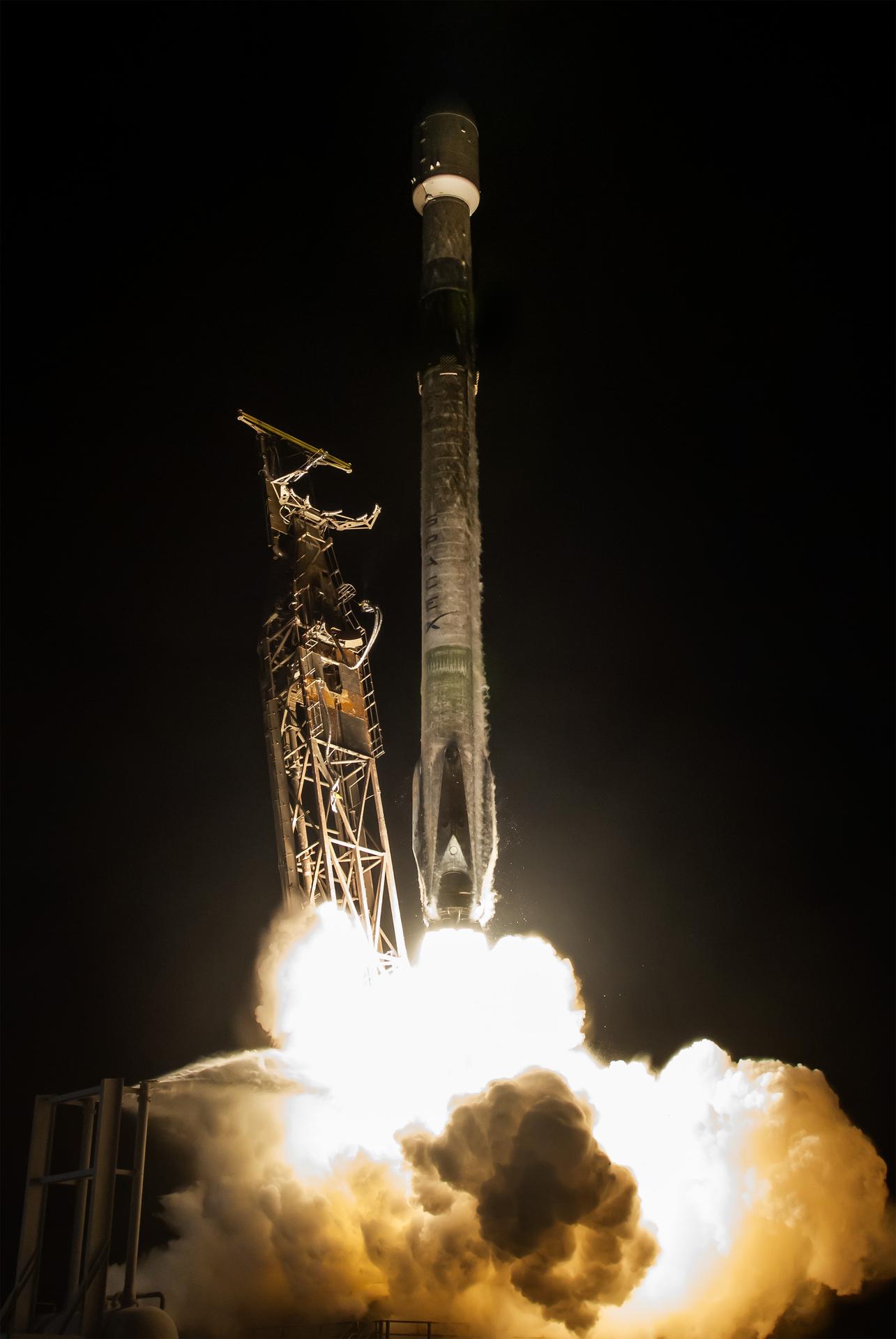
A SpaceX Falcon 9 rocket carrying NASA’s Pandora small satellite, the Star-Planet Activity Research CubeSat (SPARCS), and Black Hole Coded Aperture Telescope (BlackCAT) CubeSat lifts off from Space Launch Complex 4 East at Vandenberg Space Force Base in California on Sunday, Jan. 11, 2026. Pandora will provide an in-depth study of at least 20 known planets orbiting distant stars to determine the composition of their atmospheres — especially the presence of hazes, clouds, and water.
A SpaceX Falcon 9 rocket carrying NASA’s Pandora small satellite, the Star-Planet Activity Research CubeSat (SPARCS), and Black Hole Coded Aperture Telescope (BlackCAT) CubeSat lifts off from Space Launch Complex 4 East at Vandenberg Space Force Base in California on Sunday, Jan. 11, 2026. Pandora will provide an in-depth study of at least 20 known planets orbiting distant stars to determine the composition of their atmospheres — especially the presence of hazes, clouds, and water.
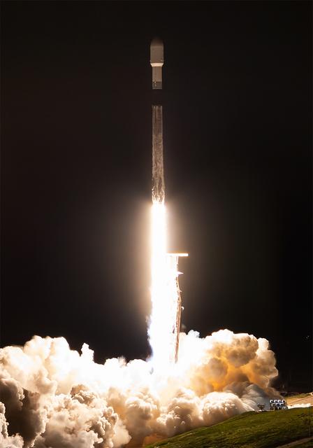
A SpaceX Falcon 9 rocket carrying NASA’s Pandora small satellite, the Star-Planet Activity Research CubeSat (SPARCS), and Black Hole Coded Aperture Telescope (BlackCAT) CubeSat lifts off from Space Launch Complex 4 East at Vandenberg Space Force Base in California on Sunday, Jan. 11, 2026. Pandora will provide an in-depth study of at least 20 known planets orbiting distant stars to determine the composition of their atmospheres — especially the presence of hazes, clouds, and water.

A SpaceX Falcon 9 rocket carrying NASA’s Pandora small satellite, the Star-Planet Activity Research CubeSat (SPARCS), and Black Hole Coded Aperture Telescope (BlackCAT) CubeSat lifts off from Space Launch Complex 4 East at Vandenberg Space Force Base in California on Sunday, Jan. 11, 2026. Pandora will provide an in-depth study of at least 20 known planets orbiting distant stars to determine the composition of their atmospheres — especially the presence of hazes, clouds, and water.
A SpaceX Falcon 9 rocket carrying NASA’s Pandora small satellite, the Star-Planet Activity Research CubeSat (SPARCS), and Black Hole Coded Aperture Telescope (BlackCAT) CubeSat lifts off from Space Launch Complex 4 East at Vandenberg Space Force Base in California on Sunday, Jan. 11, 2026. Pandora will provide an in-depth study of at least 20 known planets orbiting distant stars to determine the composition of their atmospheres — especially the presence of hazes, clouds, and water.

A SpaceX Falcon 9 rocket carrying NASA’s Pandora small satellite, the Star-Planet Activity Research CubeSat (SPARCS), and Black Hole Coded Aperture Telescope (BlackCAT) CubeSat lifts off from Space Launch Complex 4 East at Vandenberg Space Force Base in California on Sunday, Jan. 11, 2026. Pandora will provide an in-depth study of at least 20 known planets orbiting distant stars to determine the composition of their atmospheres — especially the presence of hazes, clouds, and water.
A SpaceX Falcon 9 rocket carrying NASA’s Pandora small satellite, the Star-Planet Activity Research CubeSat (SPARCS), and Black Hole Coded Aperture Telescope (BlackCAT) CubeSat lifts off from Space Launch Complex 4 East at Vandenberg Space Force Base in California on Sunday, Jan. 11, 2026. Pandora will provide an in-depth study of at least 20 known planets orbiting distant stars to determine the composition of their atmospheres — especially the presence of hazes, clouds, and water.
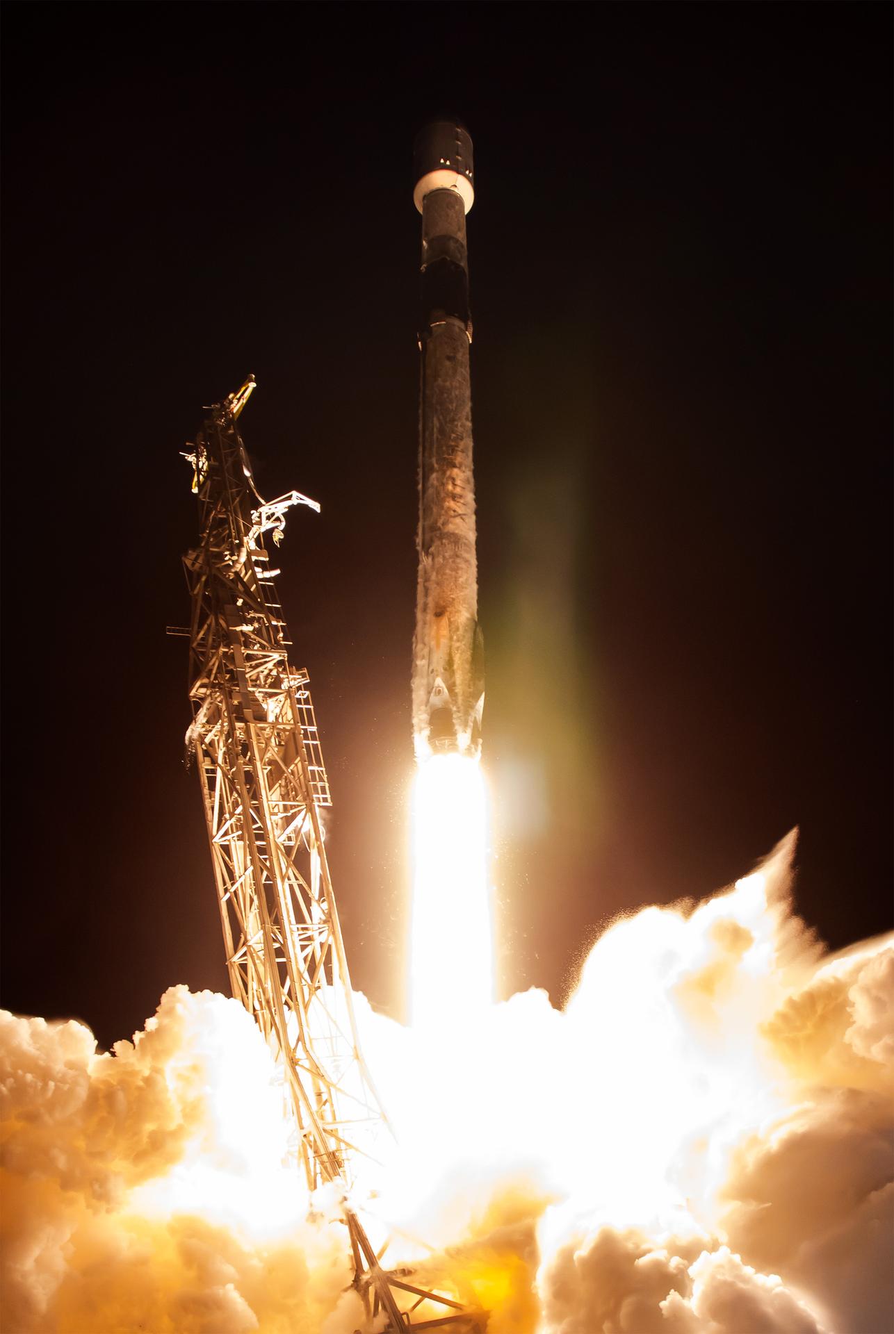
A SpaceX Falcon 9 rocket carrying NASA’s Pandora small satellite, the Star-Planet Activity Research CubeSat (SPARCS), and Black Hole Coded Aperture Telescope (BlackCAT) CubeSat lifts off from Space Launch Complex 4 East at Vandenberg Space Force Base in California on Sunday, Jan. 11, 2026. Pandora will provide an in-depth study of at least 20 known planets orbiting distant stars to determine the composition of their atmospheres — especially the presence of hazes, clouds, and water.
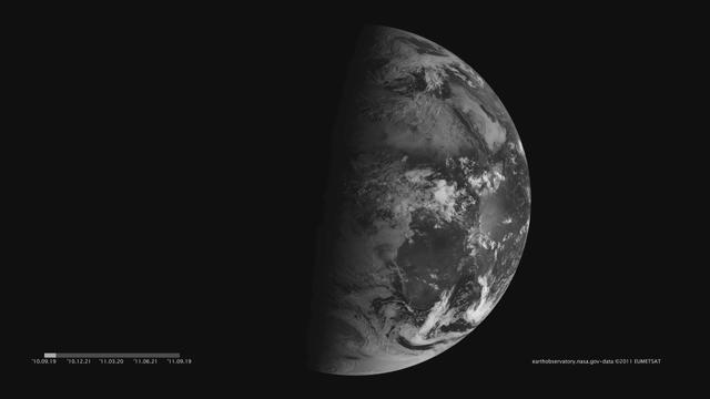
Images acquired December 21, 2010 - September 20, 2011. To download the high res and learn more go to: <a href="http://earthobservatory.nasa.gov/IOTD/view.php?id=52248" rel="nofollow">earthobservatory.nasa.gov/IOTD/view.php?id=52248</a> One of the most frequently misunderstood concepts in science is the reason for Earth’s seasons. As we experience the September equinox today—anyone try to balance an egg yet?—we thought we’d offer a space-based view of what’s going on. Around 6 a.m. local time each day, the Sun, Earth, and any geosynchronous satellite form a right angle, affording a nadir (straight down) view of the terminator, where the shadows of nightfall meet the sunlight of dusk and dawn. The shape of this line between night and day varies with the seasons, which means different lengths of days and differing amounts of warming sunshine. (The line is actually a curve because the Earth is round, but satellite images only show it in two-dimensions.) The Spinning Enhanced Visible and Infrared Imager (SEVIRI) on EUMETSAT's Meteosat-9 captured these four views of the day-night terminator on December 21, 2010, and March 20, June 21, and September 20, 2011. Each image was taken at 6:12 a.m. local time. On March 20 and September 20, the terminator is a straight north-south line, and the Sun is said to sit directly above the equator. On December 21, the Sun resides directly over the Tropic of Capricorn when viewed from the ground, and sunlight spreads over more of the Southern Hemisphere. On June 21, the Sun sits above the Tropic of Cancer, spreading more sunlight in the north and turning the tables on the south. The bulge of our spherical Earth blocks sunlight from the far hemisphere at the solstices; that same curvature allows the Sun’s rays to spread over more area near the top and bottom of the globe. Of course, it is not the Sun that is moving north or south through the seasons, but a change in the orientation and angles between the Earth and its nearest star. The axis of the Earth is tilted 23.5 degrees relative to the Sun and the ecliptic plane. The axis is tilted away from the Sun at the December solstice and toward the Sun at the June solstice, spreading more and less light on each hemisphere. At the equinoxes, the tilt is at a right angle to the Sun and the light is spread evenly. The equinox and changing of the seasons occurs on September 23, 2011 at 9:05 a.m. Universal Time. (Our September image above is a few days early.) Equinox means "equal night" in Latin, capturing the idea that daytime and nighttime are equal lengths everywhere on the planet. That is true of the Sun's presence above the horizon, though it does not account for twilight, when the Sun's rays extend from beyond the horizon to illuminate our gas-filled atmosphere. <b>NASA images and animation by Robert Simmon, using data ©2010 EUMETSAT. Caption by Mike Carlowicz.</b> Instrument: Meteosat Credit: <b><a href="http://www.earthobservatory.nasa.gov/" rel="nofollow"> NASA Earth Observatory</a></b> <b><a href="http://www.nasa.gov/audience/formedia/features/MP_Photo_Guidelines.html" rel="nofollow">NASA image use policy.</a></b> <b><a href="http://www.nasa.gov/centers/goddard/home/index.html" rel="nofollow">NASA Goddard Space Flight Center</a></b> enables NASA’s mission through four scientific endeavors: Earth Science, Heliophysics, Solar System Exploration, and Astrophysics. Goddard plays a leading role in NASA’s accomplishments by contributing compelling scientific knowledge to advance the Agency’s mission. <b>Follow us on <a href="http://twitter.com/NASAGoddardPix" rel="nofollow">Twitter</a></b> <b>Like us on <a href="http://www.facebook.com/pages/Greenbelt-MD/NASA-Goddard/395013845897?ref=tsd" rel="nofollow">Facebook</a></b> <b>Find us on <a href="http://instagrid.me/nasagoddard/?vm=grid" rel="nofollow">Instagram</a></b>
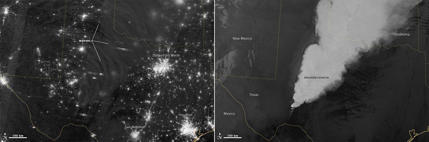
In April 2012, waves in Earth’s “airglow” spread across the nighttime skies of northern Texas like ripples in a pond. In this case, the waves were provoked by a massive thunderstorm. Airglow is a layer of nighttime light emissions caused by chemical reactions high in Earth’s atmosphere. A variety of reactions involving oxygen, sodium, ozone and nitrogen result in the production of a very faint amount of light. In fact, it’s approximately one billion times fainter than sunlight (~10-11 to 10-9 W·cm-2· sr-1). This chemiluminescence is similar to the chemical reactions that light up a glow stick or glow-in-the-dark silly putty. The “day-night band,” of the Visible Infrared Imaging Radiometer Suite (VIIRS) on the Suomi NPP satellite captured these glowing ripples in the night sky on April 15, 2012 (top image). The day-night band detects lights over a range of wavelengths from green to near-infrared and uses highly sensitive electronics to observe low light signals. (The absolute minimum signals detectable are at the levels of nightglow emission.) The lower image shows the thunderstorm as observed by a thermal infrared band on VIIRS. This thermal band, which is sensitive only to heat emissions (cold clouds appear white), is not sensitive to the subtle visible-light wave structures seen by the day-night band. Technically speaking, airglow occurs at all times. During the day it is called “dayglow,” at twilight “twilightglow,” and at night “nightglow.” There are slightly different processes taking place in each case, but in the image above the source of light is nightglow. The strongest nightglow emissions are mostly constrained to a relatively thin layer of atmosphere between 85 and 95 kilometers (53 and 60 miles) above the Earth’s surface. Little emission occurs below this layer since there’s a higher concentration of molecules, allowing for dissipation of chemical energy via collisions rather than light production. Likewise, little emission occurs above that layer because the atmospheric density is so tenuous that there are too few light-emitting reactions to yield an appreciable amount of light. Suomi NPP is in orbit around Earth at 834 kilometers (about 518 miles), well above the nightglow layer. The day-night band imagery therefore contains signals from the direction upward emission of the nightglow layer and the reflection of the downward nightglow emissions by clouds and the Earth’s surface. The presence of these nightglow waves is a graphic visualization of the usually unseen energy transfer processes that occur continuously between the lower and upper atmosphere. While nightglow is a well-known phenomenon, it’s not typically considered by Earth-viewing meteorological sensors. In fact, scientists were surprised at Suomi NPP’s ability to detect it. During the satellite’s check-out procedure, this unanticipated source of visible light was thought to indicate a problem with the sensor until scientists realized that what they were seeing was the faintest of light in the darkness of night. NASA Earth Observatory image by Jesse Allen and Robert Simmon, using VIIRS Day-Night Band data from the Suomi National Polar-orbiting Partnership. Suomi NPP is the result of a partnership between NASA, the National Oceanic and Atmospheric Administration, and the Department of Defense. Caption by Aries Keck and Steve Miller. Instrument: Suomi NPP - VIIRS Credit: <b><a href="http://www.earthobservatory.nasa.gov/" rel="nofollow"> NASA Earth Observatory</a></b> <b>Click here to view all of the <a href="http://earthobservatory.nasa.gov/Features/NightLights/" rel="nofollow"> Earth at Night 2012 images </a></b> <b>Click here to <a href="http://earthobservatory.nasa.gov/NaturalHazards/view.php?id=79817" rel="nofollow"> read more </a> about this image </b> <b><a href="http://www.nasa.gov/audience/formedia/features/MP_Photo_Guidelines.html" rel="nofollow">NASA image use policy.</a></b> <b><a href="http://www.nasa.gov/centers/goddard/home/index.html" rel="nofollow">NASA Goddard Space</a></b>

Images acquired December 21, 2010 - September 20, 2011. To view a HD animation of this go to: <a href="http://www.flickr.com/photos/gsfc/6175313242/in/photostream/">www.flickr.com/photos/gsfc/6175313242/in/photostream/</a> To download the high res and learn more go to: <a href="http://earthobservatory.nasa.gov/IOTD/view.php?id=52248" rel="nofollow">earthobservatory.nasa.gov/IOTD/view.php?id=52248</a> One of the most frequently misunderstood concepts in science is the reason for Earth’s seasons. As we experience the September equinox today—anyone try to balance an egg yet?—we thought we’d offer a space-based view of what’s going on. Around 6 a.m. local time each day, the Sun, Earth, and any geosynchronous satellite form a right angle, affording a nadir (straight down) view of the terminator, where the shadows of nightfall meet the sunlight of dusk and dawn. The shape of this line between night and day varies with the seasons, which means different lengths of days and differing amounts of warming sunshine. (The line is actually a curve because the Earth is round, but satellite images only show it in two-dimensions.) The Spinning Enhanced Visible and Infrared Imager (SEVIRI) on EUMETSAT's Meteosat-9 captured these four views of the day-night terminator on December 21, 2010, and March 20, June 21, and September 20, 2011. Each image was taken at 6:12 a.m. local time. On March 20 and September 20, the terminator is a straight north-south line, and the Sun is said to sit directly above the equator. On December 21, the Sun resides directly over the Tropic of Capricorn when viewed from the ground, and sunlight spreads over more of the Southern Hemisphere. On June 21, the Sun sits above the Tropic of Cancer, spreading more sunlight in the north and turning the tables on the south. The bulge of our spherical Earth blocks sunlight from the far hemisphere at the solstices; that same curvature allows the Sun’s rays to spread over more area near the top and bottom of the globe. Of course, it is not the Sun that is moving north or south through the seasons, but a change in the orientation and angles between the Earth and its nearest star. The axis of the Earth is tilted 23.5 degrees relative to the Sun and the ecliptic plane. The axis is tilted away from the Sun at the December solstice and toward the Sun at the June solstice, spreading more and less light on each hemisphere. At the equinoxes, the tilt is at a right angle to the Sun and the light is spread evenly. The equinox and changing of the seasons occurs on September 23, 2011 at 9:05 a.m. Universal Time. (Our September image above is a few days early.) Equinox means "equal night" in Latin, capturing the idea that daytime and nighttime are equal lengths everywhere on the planet. That is true of the Sun's presence above the horizon, though it does not account for twilight, when the Sun's rays extend from beyond the horizon to illuminate our gas-filled atmosphere. NASA images and animation by Robert Simmon, using data ©2010 EUMETSAT. Caption by Mike Carlowicz. Instrument: Meteosat Credit: <b><a href="http://www.earthobservatory.nasa.gov/" rel="nofollow"> NASA Earth Observatory</a></b> <b><a href="http://www.nasa.gov/audience/formedia/features/MP_Photo_Guidelines.html" rel="nofollow">NASA image use policy.</a></b> <b><a href="http://www.nasa.gov/centers/goddard/home/index.html" rel="nofollow">NASA Goddard Space Flight Center</a></b> enables NASA’s mission through four scientific endeavors: Earth Science, Heliophysics, Solar System Exploration, and Astrophysics. Goddard plays a leading role in NASA’s accomplishments by contributing compelling scientific knowledge to advance the Agency’s mission. <b>Follow us on <a href="http://twitter.com/NASAGoddardPix" rel="nofollow">Twitter</a></b> <b>Like us on <a href="http://www.facebook.com/pages/Greenbelt-MD/NASA-Goddard/395013845897?ref=tsd" rel="nofollow">Facebook</a></b> <b>Find us on <a href="http://instagrid.me/nasagoddard/?vm=grid" rel="nofollow">Instagram</a></b>