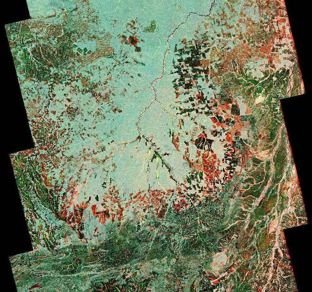
To show the kind of imagery that data from the NISAR (NASA-ISRO Synthetic Aperture Radar) satellite mission will produce, researchers pointed to this composite image of a portion of the so-called "arc of deforestation," a region on the southeast edge of the Amazonian jungle in Brazil where forests are being cleared at a fast pace through human activity. This three-color image shows change to the land cover in the Xingu River basin between 1996 (red) and 2007 (blue/green), using data from the Japanese L-band SAR satellites JERS-1 and ALOS-1, respectively. Black indicates areas converted from rainforest to agricultural land prior to 1996, and red shows the additional areas that had been cleared by 2007. NISAR will offer detailed insights into how the planet's forest ecosystems are changing over time, which will help researchers understand regional and global dynamics of deforestation and study the role of wooded areas in the global carbon cycle. NISAR could also help improve accounting of forest loss and growth, as countries that rely on logging try to shift toward more sustainable practices. NISAR is a joint mission of the U.S. and Indian space agencies. When in orbit, its sophisticated L- and S-band radar systems will scan nearly all of Earth's land and ice surfaces twice every 12 days with exquisite precision. Scheduled to launch in early 2024, NISAR is an equal collaboration between NASA and the Indian Space Research Organisation and marks the first time the two agencies have cooperated on hardware development for an Earth-observing mission. NASA's Jet Propulsion Laboratory, which is managed for the agency by Caltech in Pasadena, leads the U.S. component of the project and is providing the mission's L-band SAR. NASA is also providing the radar reflector antenna, the deployable boom, a high-rate communication subsystem for science data, GPS receivers, a solid-state recorder, and payload data subsystem. ISRO's U R Rao Satellite Centre in Bengaluru, which is leading the ISRO component of the mission, is providing the spacecraft bus, the S-band SAR electronics, the launch vehicle, and associated launch services and satellite mission operations. https://photojournal.jpl.nasa.gov/catalog/PIA26111
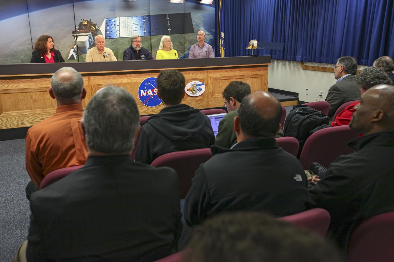
VANDENBERG AIR FORCE BASE, Calif. -- Media attend a mission science briefing at Vandenberg Air Force Base in California in preparation for the launch of the Landsat Data Continuity Mission LDCM. From left are Rani Gran of NASA Public Affairs, LDCM project scientist Dr. Jim Irons from NASA's Goddard Space Flight Center, senior scientist and co-chair of the Landsat Science Team U.S. Geological Survey Earth Resources Observation and Science EROS Center Dr. Thomas Loveland, Landsat scientist and president of Kass Green and Associates Kass Green, and senior research scientist Dr. Mike Wulder of the Landsat Science Team Canadian Forest Service, Natural Resources Canada. Launch of LDCM aboard a United Launch Alliance Atlas V rocket from Vandenberg's Space Launch Complex-3E is planned for Feb. 11 during a 48-minute launch window that opens at 10:02 a.m. PST, or 1:02 p.m. EST. LDCM is the eighth satellite in the Landsat Program series of Earth-observing missions and will continue the program’s critical role in monitoring, understanding and managing the resources needed for human sustainment, such as food, water and forests. NASA's Goddard Space Flight Center in Greenbelt, Md., is responsible for LDCM project management. Orbital Sciences Corp. built the LDCM satellite. NASA's Launch Services Program at the Kennedy Space Center in Florida provides launch management. After launch and the initial checkout phase, the U. S. Geological Survey will take operational control of LDCM, and it will be renamed Landsat 8. Photo credit: NASA/Kim Shiflett
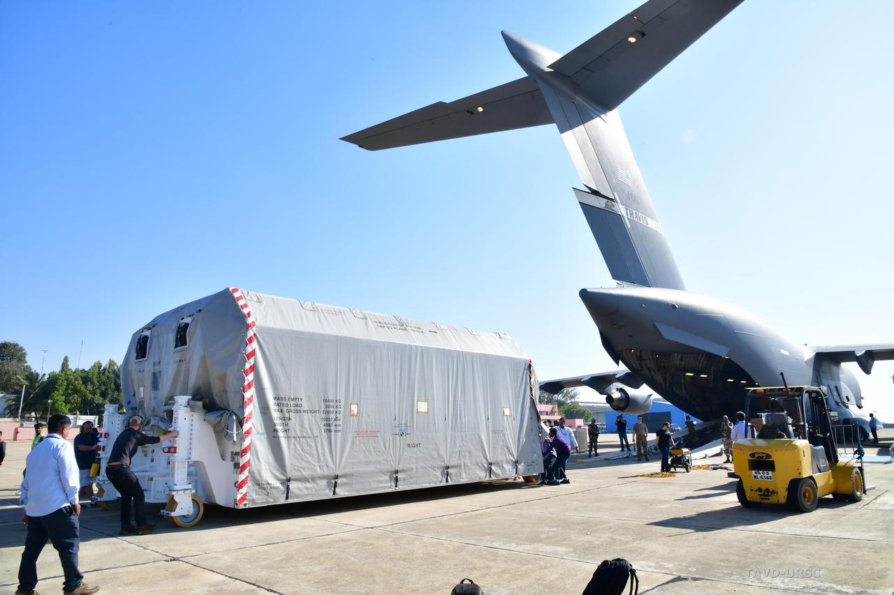
The NASA-ISRO Synthetic Aperture Radar (NISAR) science instrument payload, housed in a specially designed shipping container, sits at Hindustan Aeronautics Limited Airport in Bengaluru, India. The payload left NASA's Jet Propulsion Laboratory in Southern California on Feb. 28, and departed the United States on March 3 aboard a U.S. Air Force cargo plane, arriving in Bengaluru on March 6. From there it was transported to the Indian Space Research Organisation's U R Rao Satellite Centre, where it will be integrated with the satellite body, or bus, and undergo further testing leading up to launch in 2024. The NISAR mission – a joint effort between NASA and the Indian Space Research Organisation – will observe nearly all the planet's land and ice surfaces twice every 12 days, measuring movements in extremely fine detail. It will also survey forests and agricultural regions to understand carbon exchange between plants and the atmosphere. NISAR's science payload will be the most advanced radar system ever launched as part of a NASA mission, and it will feature the largest-ever radar antenna of its kind: a drum-shaped, wire mesh reflector nearly 40 feet (12 meters) in diameter that will extend from a 30-foot (9-meter) boom. The mission's science instruments consist of L- and S-band radar, so named to indicate the wavelengths of their signals. ISRO built the S-band radar, which it shipped to JPL in March 2021. Engineers spent much of the last two years integrating the instrument with the JPL-built L-band system, then conducting tests to verify they work well together. JPL, which is managed for NASA by Caltech in Pasadena, leads the U.S. component of NISAR. In addition to the L-band radar, NASA is also providing the radar reflector antenna, the deployable boom, a high-rate communication subsystem for science data, GPS receivers, a solid-state recorder, and payload data subsystem. In addition to the S-band radar, ISRO is providing the spacecraft bus, the launch vehicle, and associated launch services and satellite mission operations. https://photojournal.jpl.nasa.gov/catalog/PIA25570
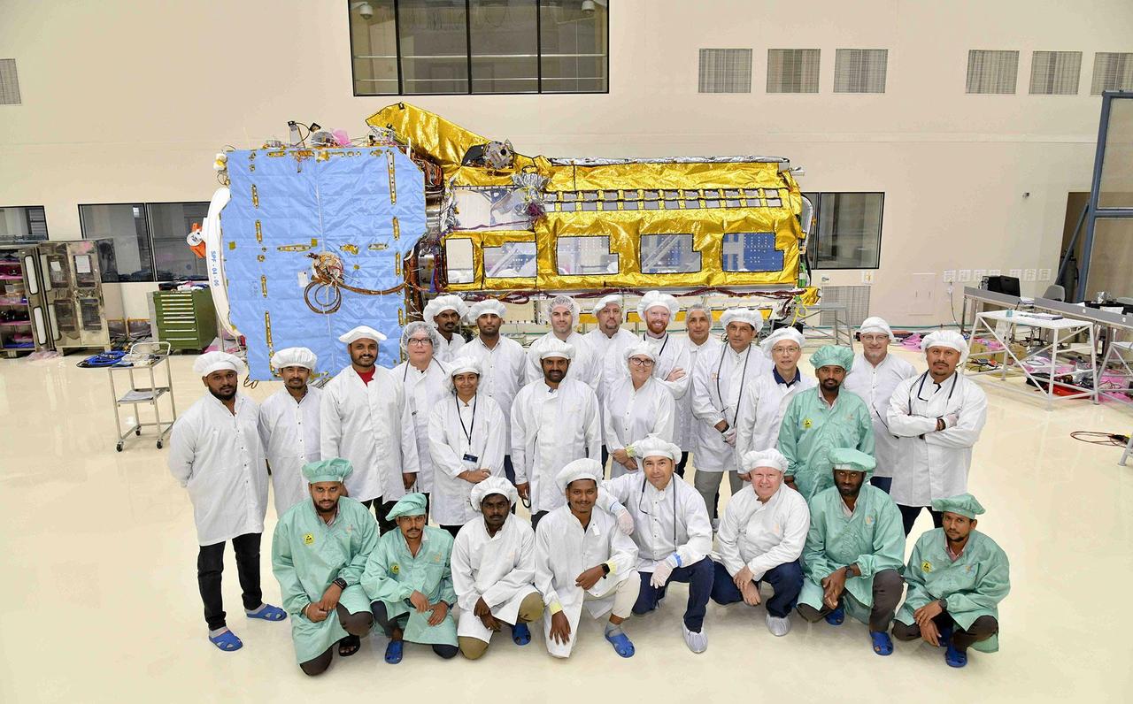
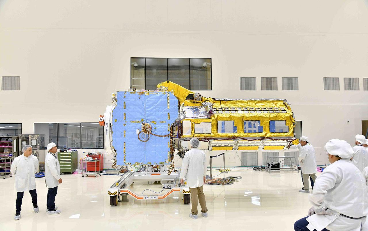
A team of engineers and technicians from the Indian Space Research Organisation and NASA's Jet Propulsion Laboratory in Southern California pose in June at ISRO's U R Rao Satellite Centre (URSC) in Bengaluru, India, after working together to combine the two main components of the NISAR (NASA-ISRO Synthetic Aperture Radar) satellite. Set to launch in early 2024 from the Satish Dhawan Space Centre in Sriharikota, India, NISAR is being jointly developed by NASA and ISRO to observe movements of Earth's land and ice surfaces in extremely fine detail. As NISAR observes nearly every part of Earth at least once every 12 days, the satellite will help scientists understand, among other observables, the dynamics of forests, wetlands, and agricultural lands. The radar instrument payload, partially wrapped in gold-colored thermal blanketing, arrived from JPL in March and consists of L- and S-band radar systems, so named to indicate the wavelengths of their signals. Both sensors can see through clouds and collect data day and night. The bus, which is shown in blue blanketing and includes components and systems developed by both ISRO and JPL, was built at URSC and will provide power, navigation, pointing control, and communications for the mission. The team combined the payload and the bus with the help of a crane. NISAR is an equal collaboration between NASA and ISRO and marks the first time the two agencies have cooperated on hardware development for an Earth-observing mission. JPL, which is managed for NASA by Caltech in Pasadena, leads the U.S. component of the project and is providing the mission's L-band SAR. NASA is also providing the radar reflector antenna, the deployable boom, a high-rate communication subsystem for science data, GPS receivers, a solid-state recorder, and payload data subsystem. URSC, which is leading the ISRO component of the mission, is providing the spacecraft bus, the S-band SAR electronics, the launch vehicle, and associated launch services and satellite mission operations. https://photojournal.jpl.nasa.gov/catalog/PIA25867
Engineers from NASA's Jet Propulsion Laboratory in Southern California and the Indian Space Research Organisation (ISRO), working in a clean room facility at ISRO's U R Rao Satellite Centre (URSC) in Bengaluru, India, in mid-June 2023, use a crane to align the radar instrument payload for the NISAR (NASA-ISRO Synthetic Aperture Radar) mission above the satellite's spacecraft bus so that the two components can be combined. Set to launch in early 2024 from the Satish Dhawan Space Centre in Sriharikota, India, NISAR is being jointly developed by NASA and ISRO to observe movements of Earth's land and ice surfaces in extremely fine detail. As NISAR observes nearly every part of Earth at least once every 12 days, the satellite will help scientists understand, among other observables, the dynamics of forests, wetlands, and agricultural lands. The radar instrument payload, partially wrapped in gold-colored thermal blanketing, arrived from JPL in March and consists of L- and S-band radar systems, so named to indicate the wavelengths of their signals. Both sensors can see through clouds and collect data day and night. The bus, which is shown in blue blanketing and includes components and systems developed by both ISRO and JPL, was built at URSC and will provide power, navigation, pointing control, and communications for the mission. NISAR is an equal collaboration between NASA and ISRO and marks the first time the two agencies have cooperated on hardware development for an Earth-observing mission. JPL, which is managed for NASA by Caltech in Pasadena, leads the U.S. component of the project and is providing the mission's L-band SAR. NASA is also providing the radar reflector antenna, the deployable boom, a high-rate communication subsystem for science data, GPS receivers, a solid-state recorder, and payload data subsystem. URSC, which is leading the ISRO component of the mission, is providing the spacecraft bus, the S-band SAR electronics, the launch vehicle, and associated launch services and satellite mission operations. https://photojournal.jpl.nasa.gov/catalog/PIA25866
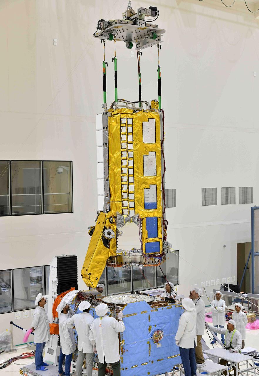
The NISAR (NASA-ISRO Synthetic Aperture Radar) satellite sits in a clean room facility at U R Rao Satellite Centre (URSC) in Bengaluru, India, in mid-June 2023, shortly after engineers from NASA's Jet Propulsion Laboratory in Southern California and the Indian Space Research Organisation joined its two main components, the radar instrument payload and the spacecraft bus. Set to launch in early 2024 from the Satish Dhawan Space Centre in Sriharikota, India, NISAR is being jointly developed by NASA and ISRO to observe movements of Earth's land and ice surfaces in extremely fine detail. As NISAR observes nearly every part of Earth at least once every 12 days, the satellite will help scientists understand, among other observables, the dynamics of forests, wetlands, and agricultural lands. The radar instrument payload, partially wrapped in gold-colored thermal blanketing, arrived from JPL in March and consists of L- and S-band radar systems, so named to indicate the wavelengths of their signals. Both sensors can see through clouds and collect data day and night. The bus, which is shown in blue blanketing and includes components and systems developed by both ISRO and JPL, was built at URSC and will provide power, navigation, pointing control, and communications for the mission. NISAR is an equal collaboration between NASA and ISRO and marks the first time the two agencies have cooperated on hardware development for an Earth-observing mission. JPL, which is managed for NASA by Caltech in Pasadena, leads the U.S. component of the project and is providing the mission's L-band SAR. NASA is also providing the radar reflector antenna, the deployable boom, a high-rate communication subsystem for science data, GPS receivers, a solid-state recorder, and payload data subsystem. URSC, which is leading the ISRO component of the mission, is providing the spacecraft bus, the S-band SAR electronics, the launch vehicle, and associated launch services and satellite mission operations. https://photojournal.jpl.nasa.gov/catalog/PIA25865

To show the kind of imagery that data from the NISAR (NASA-ISRO Synthetic Aperture Radar) satellite mission will be used to produce, researchers pointed to a 2013 image of flooding extent in the Pacaya-Samaria National Reserve that used data from the Uninhabited Aerial Vehicle Synthetic Aperture Radar (UAVSAR), an airborne system. In the image of this flood-prone area of the Amazonian jungle in Peru, black indicates open water, grayish-green is tropical forest, dark green is low-lying or floating vegetation, and red and pink are two different types of flooded vegetation. NISAR will offer detailed insights into the flooding patterns of the planet's wetland ecosystems, which will help researchers understand how these areas are being affected by climate change and human activity and the role they play in the global carbon cycle. NISAR is a joint mission of the U.S. and Indian space agencies. When in orbit, its sophisticated L- and S-band radar systems will scan nearly all of Earth's land and ice surfaces twice every 12 days with exquisite precision. Scheduled to launch in early 2024, NISAR is an equal collaboration between NASA and the Indian Space Research Organisation and marks the first time the two agencies have cooperated on hardware development for an Earth-observing mission. NASA's Jet Propulsion Laboratory, which is managed for the agency by Caltech in Pasadena, leads the U.S. component of the project and is providing the mission's L-band SAR. NASA is also providing the radar reflector antenna, the deployable boom, a high-rate communication subsystem for science data, GPS receivers, a solid-state recorder, and payload data subsystem. ISRO's U R Rao Satellite Centre in Bengaluru, which is leading the ISRO component of the mission, is providing the spacecraft bus, the S-band SAR electronics, the launch vehicle, and associated launch services and satellite mission operations. https://photojournal.jpl.nasa.gov/catalog/PIA26112
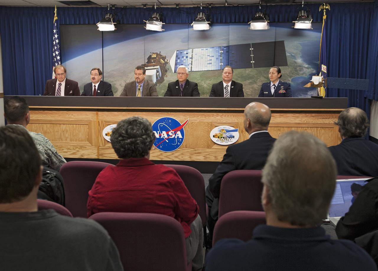
VANDENBERG AIR FORCE BASE, Calif. -- Media attend a prelaunch press conference at Vandenberg Air Force Base in California to discuss NASA's readiness to launch the Landsat Data Continuity Mission LDCM. From left are George Diller of NASA Public Affairs, LDCM program executive David Jarrett from NASA Headquarters, NASA Launch Director Omar Baez from Kennedy Space Center, United Launch Alliance Program Manager for NASA Missions Vernon Thorp, LDCM Project Manager Ken Schwer from Goddard Space Flight Center, and 1st Lt. Jennifer Kelley, launch weather officer for the 30th Operations Support Squadron at Vandenberg. Launch of LDCM aboard a United Launch Alliance Atlas V rocket from Vandenberg's Space Launch Complex-3E is planned for Feb. 11 during a 48-minute launch window that opens at 10:02 a.m. PST, or 1:02 p.m. EST. LDCM is the eighth satellite in the Landsat Program series of Earth-observing missions and will continue the program’s critical role in monitoring, understanding and managing the resources needed for human sustainment, such as food, water and forests. NASA's Goddard Space Flight Center in Greenbelt, Md., is responsible for LDCM project management. Orbital Sciences Corp. built the LDCM satellite. NASA's Launch Services Program at the Kennedy Space Center in Florida provides launch management. After launch and the initial checkout phase, the U. S. Geological Survey will take operational control of LDCM, and it will be renamed Landsat 8. Photo credit: NASA/Kim Shiflett