
This 1970 photograph shows Skylab's Ultraviolet (UV) Airglow Horizon Photography experiment. It was an astrophysics investigation designed to photograph the twilight airflow and Earth's ozone layer simultaneously in visible and UV wavelengths. These observations provided information on oxygen, nitrogen, and ozone layers in the Earth's atmosphere, and on their variation during night and day cycles. The Marshall Space Flight Center had program management responsibility for the development of Skylab hardware and experiments.
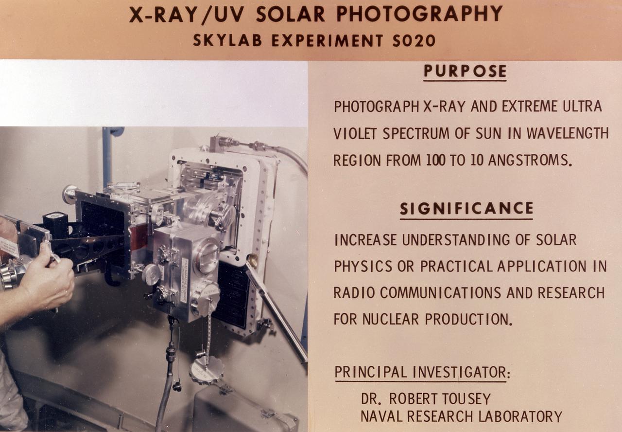
This chart details Skylab's Ultraviolet (UV) X-Ray Solar Photography experiment (S020) in an Apollo Telescope Mount facility. It was designed to photograph normal and explosive areas within the solar atmosphere in the UV and x-ray spectra. The Marshall Space Flight Center had program management responsibility for the development of Skylab hardware and experiments.
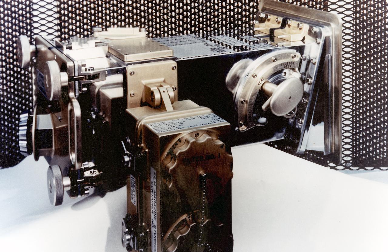
This 1970 photograph shows Skylab's Ultraviolet (UV)/X-Ray Solar Photography instrument, an Apollo Telescope Mount (ATM) facility designed to photograph normal and explosive areas in the solar atmosphere in the x-ray and UV spectra. The Marshall Space Flight Center had program management responsibility for the development of Skylab hardware and experiments.
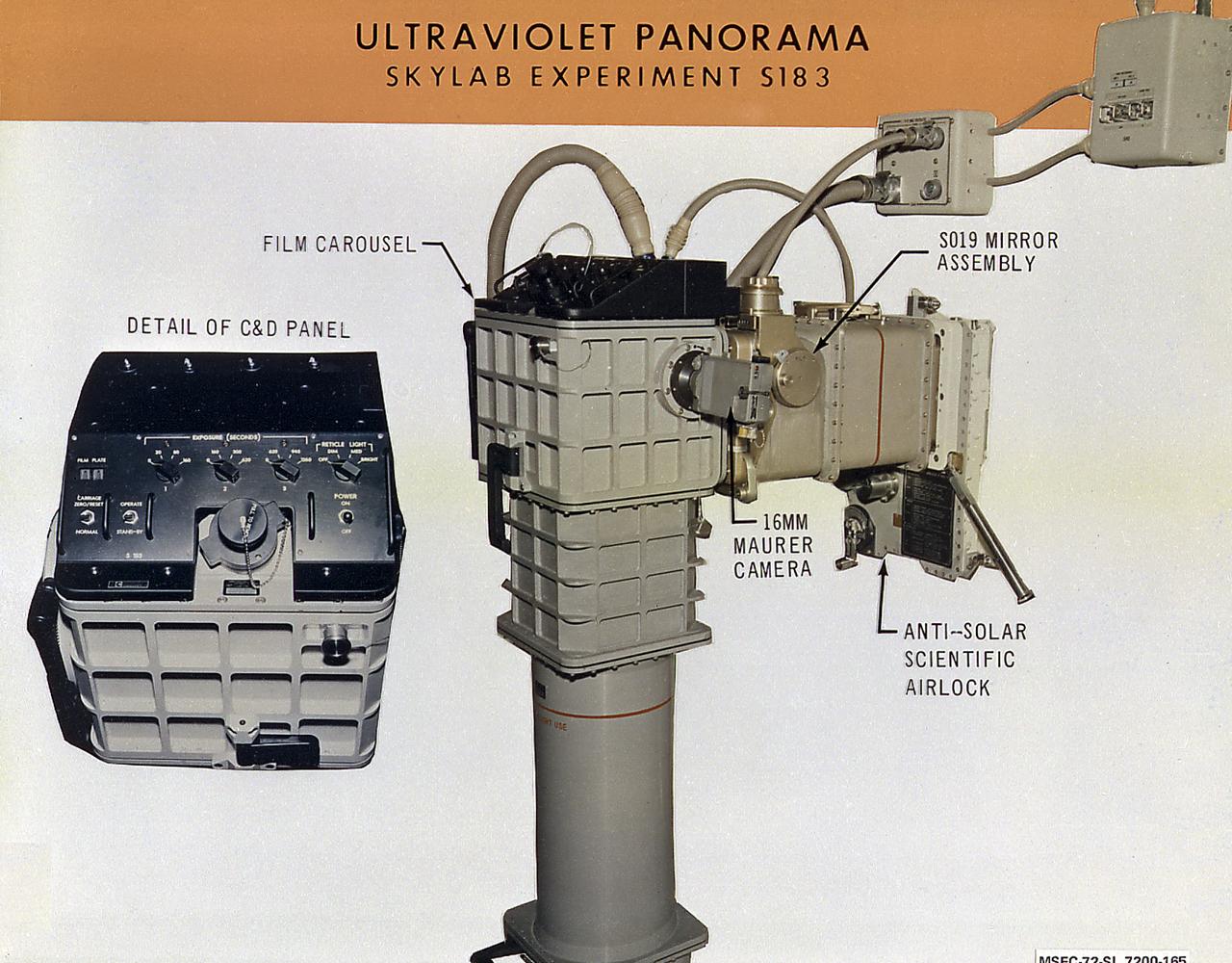
This photograph describes details of the telescopic camera for ultraviolet star photography for Skylab's Ultraviolet Panorama experiment (S183) placed in the Skylab airlock. The S183 experiment was designed to obtain ultraviolet photographs at three wavelengths of hot stars, clusters of stars, large stellar clouds in the Milky Way, and nuclei of other galaxies. The Marshall Space Flight Center had program responsibility for the development of Skylab hardware and experiments.
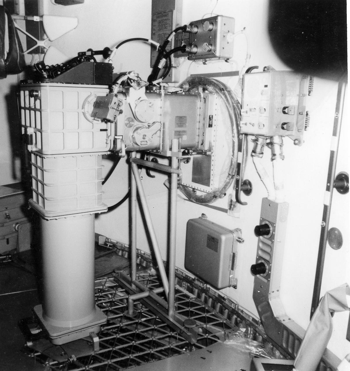
This photograph shows a telescopic camera for ultraviolet star photography for Skylab's Ultraviolet Panorama experiment (S183) placed in the Skylab airlock. The S183 experiment was designed to obtain ultraviolet photographs, at three wavelengths, of hot stars, clusters of stars, large stellar clouds in the Milky Way, and nuclei of other galaxies. The Marshall Space Flight Center had program responsibility for the development of Skylab hardware and experiments.
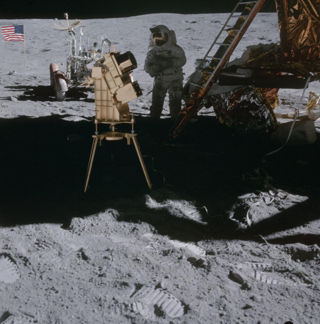
AS16-114-18439 (22 April 1972) --- Astronaut Charles M. Duke Jr., lunar module pilot, stands in the shadow of the Lunar Module (LM) behind the ultraviolet (UV) camera which is in operation. This photograph was taken by astronaut John W. Young, commander, during the mission's second extravehicular activity (EVA). The UV camera's gold surface is designed to maintain the correct temperature. The astronauts set the prescribed angles of azimuth and elevation (here 14 degrees for photography of the large Magellanic Cloud) and pointed the camera. Over 180 photographs and spectra in far-ultraviolet light were obtained showing clouds of hydrogen and other gases and several thousand stars. The United States flag and Lunar Roving Vehicle (LRV) are in the left background. While astronauts Young and Duke descended in the Apollo 16 Lunar Module (LM) "Orion" to explore the Descartes highlands landing site on the moon, astronaut Thomas K. Mattingly II, command module pilot, remained with the Command and Service Modules (CSM) "Casper" in lunar orbit.
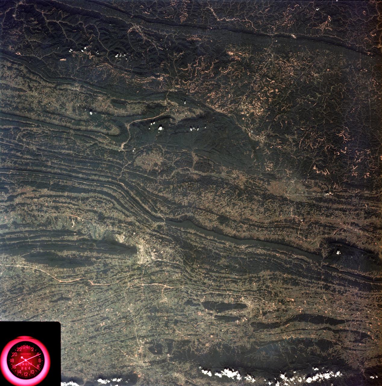
SL3-88-053 (July-September 1973) --- A near vertical view of the Tennessee-Virginia-Kentucky border area is seen in this Skylab 3 Earth Resources Experiments Package S190-B (five-inch Earth terrain camera) photograph taken from the Skylab space station in Earth orbit. The clock is in the most southerly corner of the picture. Interstate 81 under construction extends northeast-southwest across the bottom portion of the photograph. The larger urban area nearest the center of the picture is Kingsport, Tennessee. On the southern side of I-80 and east of Kingsport is the city of Bristol, Tennessee-Virginia. Johnson City, Tennessee is the urban area near the edge of the picture southeast of Kingsport. The Holston River, a tributary of the Tennessee River, meanders through the Kingsport area. The characteristic ridge and valley features in the Cumberland Plateau of Kentucky, Tennessee and Virginia are clearly visible. Forests (dark green) occur on the ridges and clearly outline the folded and faulted rock formations. The valleys (light) were formed in the softer rocks as a result of erosion. Agricultural areas are indicated by the characteristic rectangular patterns. Coal production is an important industry of this area; and it is mined by surface open pit operations. The irregular light areas in the Kentucky-Virginia border area are the strip mines which follow the contour of the land. Reclamation of the strip mine areas is aided through accurate knowledge of the mine and drainage systems. Dr. Ronald Brooks of the Wolf Research and Development Corporation can use this photograph in study of strip mine areas in the east central U.S. Federal agencies participating with NASA on the EREP project are the Departments of Agriculture, Commerce, Interior, the Environmental Protection Agency and the Corps of Engineers. All EREP photography is available to the public through the Department of Interior’s Earth Resources Observations Systems Data Center, Sioux Falls, South Dakota, 57198. Photo credit: NASA