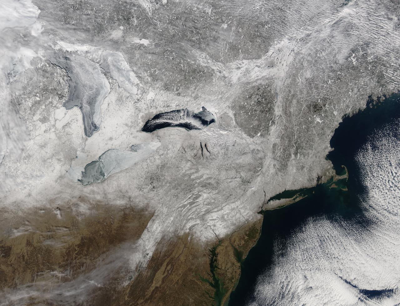
Snow covered the northeastern United States on last day of meteorological winter, 2014. Climatologists and meteorologists break seasons down into three-month groups, based on annual temperature and our calendar. This method is helpful for weather observing and forecasting, and for planning consistent agricultural dates, such as expected first frosts or best planting date. Meteorological winter – the season where temperatures are, on average, coldest and when snow is most likely to fall – runs from December 1 to February 28 in the United States and Canada. Winter can also be defined by the astronomical calendar, which is based on the rotation of the Earth around the sun. In this method, the seasons are defined by two solstices (times when the sun’s path is furthest from the Earth’s equator) and two equinoxes (the times when the sun passes directly above the equator). In the Northern Hemisphere, winter begins on the winter solstice, which falls on or around December 22 and ends on or around March 21, at the vernal (spring) equinox. On February 28, 2014, the Moderate Resolution Imaging Spectroradiometer aboard NASA’s Aqua satellite captured this true-color image of a sunny winter day in the northeastern United States. Snow stretches from Maine west to Indiana and south along the ridges of the Appalachian Mountains well into West Virginia. In Canada, the landscape appears greener, primarily because snow lies on conifers (evergreen) trees in the boreal forest regions. The Great Lakes, with the exception of Lake Ontario, are almost completely covered with ice. Credit: NASA/GSFC/Jeff Schmaltz/MODIS Land Rapid Response Team <b><a href="http://www.nasa.gov/audience/formedia/features/MP_Photo_Guidelines.html" rel="nofollow">NASA image use policy.</a></b> <b><a href="http://www.nasa.gov/centers/goddard/home/index.html" rel="nofollow">NASA Goddard Space Flight Center</a></b> enables NASA’s mission through four scientific endeavors: Earth Science, Heliophysics, Solar System Exploration, and Astrophysics. Goddard plays a leading role in NASA’s accomplishments by contributing compelling scientific knowledge to advance the Agency’s mission. <b>Follow us on <a href="http://twitter.com/NASAGoddardPix" rel="nofollow">Twitter</a></b> <b>Like us on <a href="http://www.facebook.com/pages/Greenbelt-MD/NASA-Goddard/395013845897?ref=tsd" rel="nofollow">Facebook</a></b> <b>Find us on <a href="http://instagram.com/nasagoddard?vm=grid" rel="nofollow">Instagram</a></b>
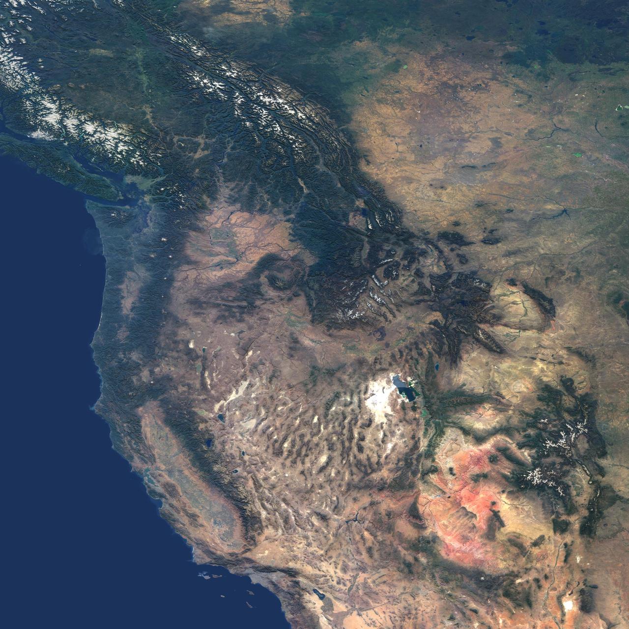
This natural-color image from NASA Terra spacecraft captures the beauty of the western United States and Canada.
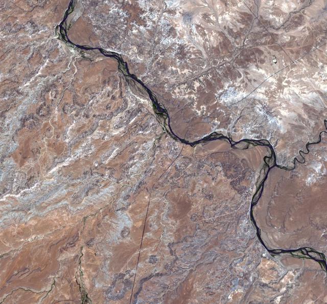
This image from NASA Terra satellite shows the only place in the United States where four states come together: the four corners area in the western U.S. At a barren, desert location, Utah, Colorado, Arizona, and New Mexico share a common point.
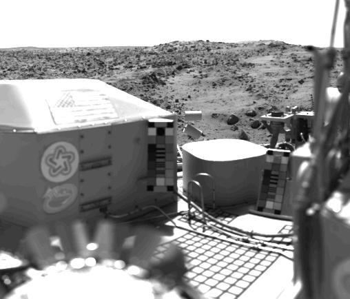
The flag of the United States stands on the surface of Mars. It is mounted on the housing of NASA's Viking 1's nuclear power system. Also seen are the U.S. Bicentennial symbol and a student designed Viking emblem. The bright flat surface near the center is the seismometer container. This picture was taken on July 23 at about 2:30 p.m. Mars time. The view is west of the spacecraft and includes a series of low hills. The blocky hill in the center appears to be part of a crater rim. The dark, rocky stripes may be material ejected from the crater. The light areas are dune-like and may be accumulations of windblown sand or dust. http://photojournal.jpl.nasa.gov/catalog/PIA00388

Funeral service for former NASA astronaut Captain Bruce McCandless II, USN (Ret.), Tuesday, Jan. 16, 2018 at the United States Naval Academy Chapel in Annapolis, Maryland. Photo Credit: (NASA/Bill Ingalls)
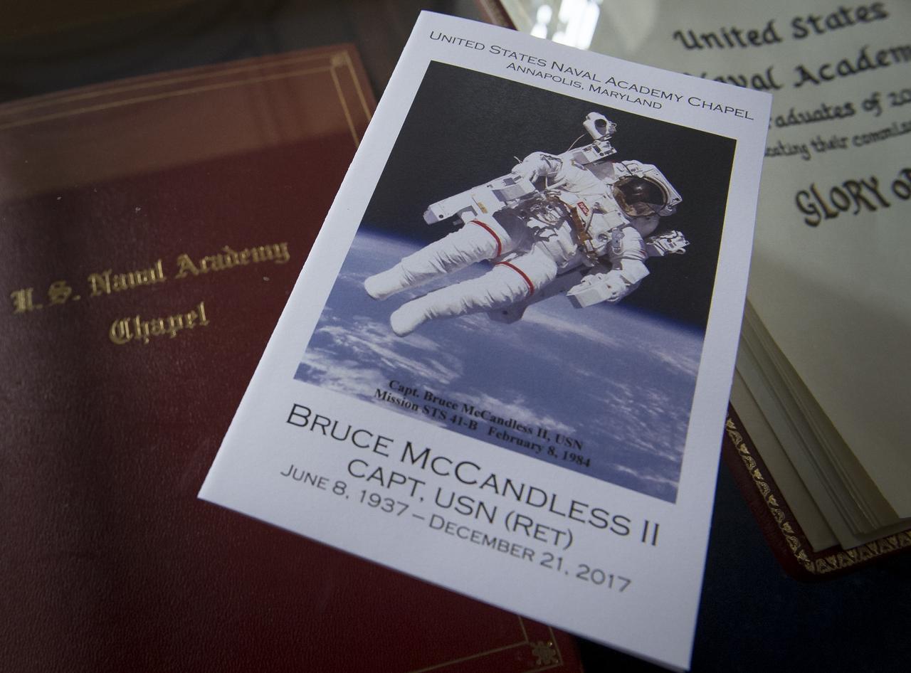
Program for the funeral service of former NASA astronaut Captain Bruce McCandless II, USN (Ret.), Tuesday, Jan. 16, 2018 at the United States Naval Academy Chapel in Annapolis, Maryland. Photo Credit: (NASA/Bill Ingalls)

Funeral service for former NASA astronaut Captain Bruce McCandless II, USN (Ret.), Tuesday, Jan. 16, 2018 at the United States Naval Academy Chapel in Annapolis, Maryland. Photo Credit: (NASA/Bill Ingalls)

Funeral service for former NASA astronaut Captain Bruce McCandless II, USN (Ret.), Tuesday, Jan. 16, 2018 at the United States Naval Academy Chapel in Annapolis, Maryland. Photo Credit: (NASA/Bill Ingalls)

Family and friends attend the funeral service for former NASA astronaut Captain Bruce McCandless II, USN (Ret.), Tuesday, Jan. 16, 2018 at the United States Naval Academy Chapel in Annapolis, Maryland. Photo Credit: (NASA/Bill Ingalls)

Family and friends depart the funeral service for former NASA astronaut Captain Bruce McCandless II, USN (Ret.), Tuesday, Jan. 16, 2018 at the United States Naval Academy Chapel in Annapolis, Maryland. Photo Credit: (NASA/Bill Ingalls)

Family and friends attend the funeral service for former NASA astronaut Captain Bruce McCandless II, USN (Ret.), Tuesday, Jan. 16, 2018 at the United States Naval Academy Chapel in Annapolis, Maryland. Photo Credit: (NASA/Bill Ingalls)

Family and friends attend the funeral service for former NASA astronaut Captain Bruce McCandless II, USN (Ret.), Tuesday, Jan. 16, 2018 at the United States Naval Academy Chapel in Annapolis, Maryland. Photo Credit: (NASA/Bill Ingalls)
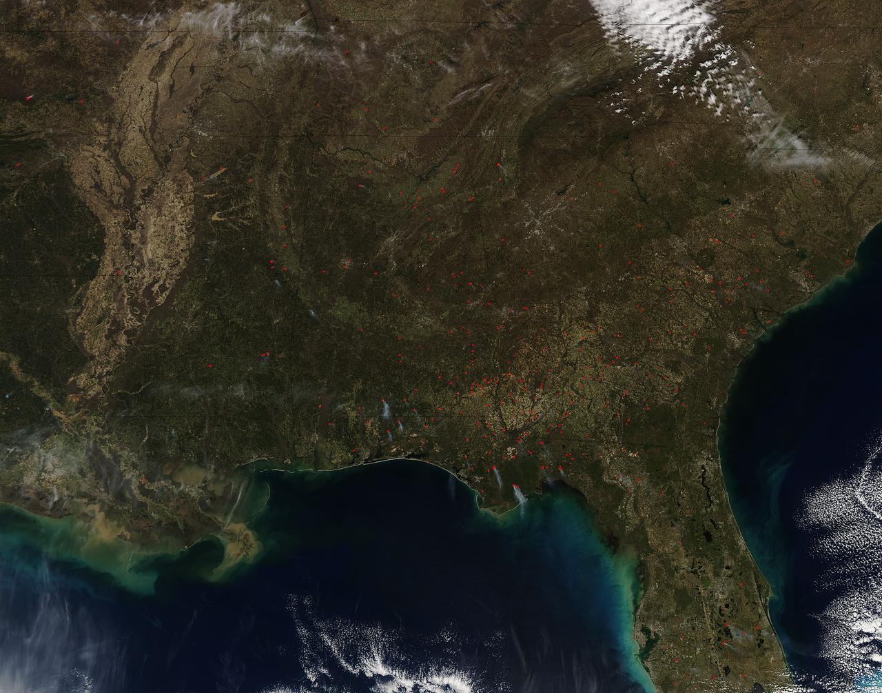
Fires both wild and prescribed dot the landscape of the southeastern portion of the United States. Wildfires are those that occur naturally with lightning strikes or are set by careless humans. Prescribed fires are those deliberately set by land management authorities to take out underlying brush and dead grass so that in the event of a wildfire there is not sufficient fuel for that fire to spread too far. The Southern Area Coordination Center for fire management has this information on its report for February 21, 2017. • Fires that have broken out recently (known as Initial Attack Activity): 198 fires for 2,292 acres • Ongoing Uncontained Large Fires: 3 fires for 5,947 acres • Other Fires reported through alternate channels: 56 fires for 1,400 acres • Prescribed Fire Activity: State and/or Federal Lands – 1,974 prescribed fires for 38,533 acres in AL, FL & GA The bulk of the fires seen in the image taken by the Aqua satellite using the onboard MODIS (Moderate Resolution Imaging Spectroradiometer) instrument on February 16, 2017 appear to be prescribed fires. Actively burning areas, detected by MODIS’s thermal bands, are outlined in red and when combined with smoke are indicative of fire. NASA image courtesy Jeff Schmaltz LANCE/EOSDIS MODIS Rapid Response Team, GSFC. Caption by Lynn Jenner with information from the Southern Area Coordination Center. <b><a href="http://www.nasa.gov/audience/formedia/features/MP_Photo_Guidelines.html" rel="nofollow">NASA image use policy.</a></b> <b><a href="http://www.nasa.gov/centers/goddard/home/index.html" rel="nofollow">NASA Goddard Space Flight Center</a></b> enables NASA’s mission through four scientific endeavors: Earth Science, Heliophysics, Solar System Exploration, and Astrophysics. Goddard plays a leading role in NASA’s accomplishments by contributing compelling scientific knowledge to advance the Agency’s mission. <b>Follow us on <a href="http://twitter.com/NASAGoddardPix" rel="nofollow">Twitter</a></b> <b>Like us on <a href="http://www.facebook.com/pages/Greenbelt-MD/NASA-Goddard/395013845897?ref=tsd" rel="nofollow">Facebook</a></b> <b>Find us on <a href="http://instagrid.me/nasagoddard/?vm=grid" rel="nofollow">Instagram</a></b>

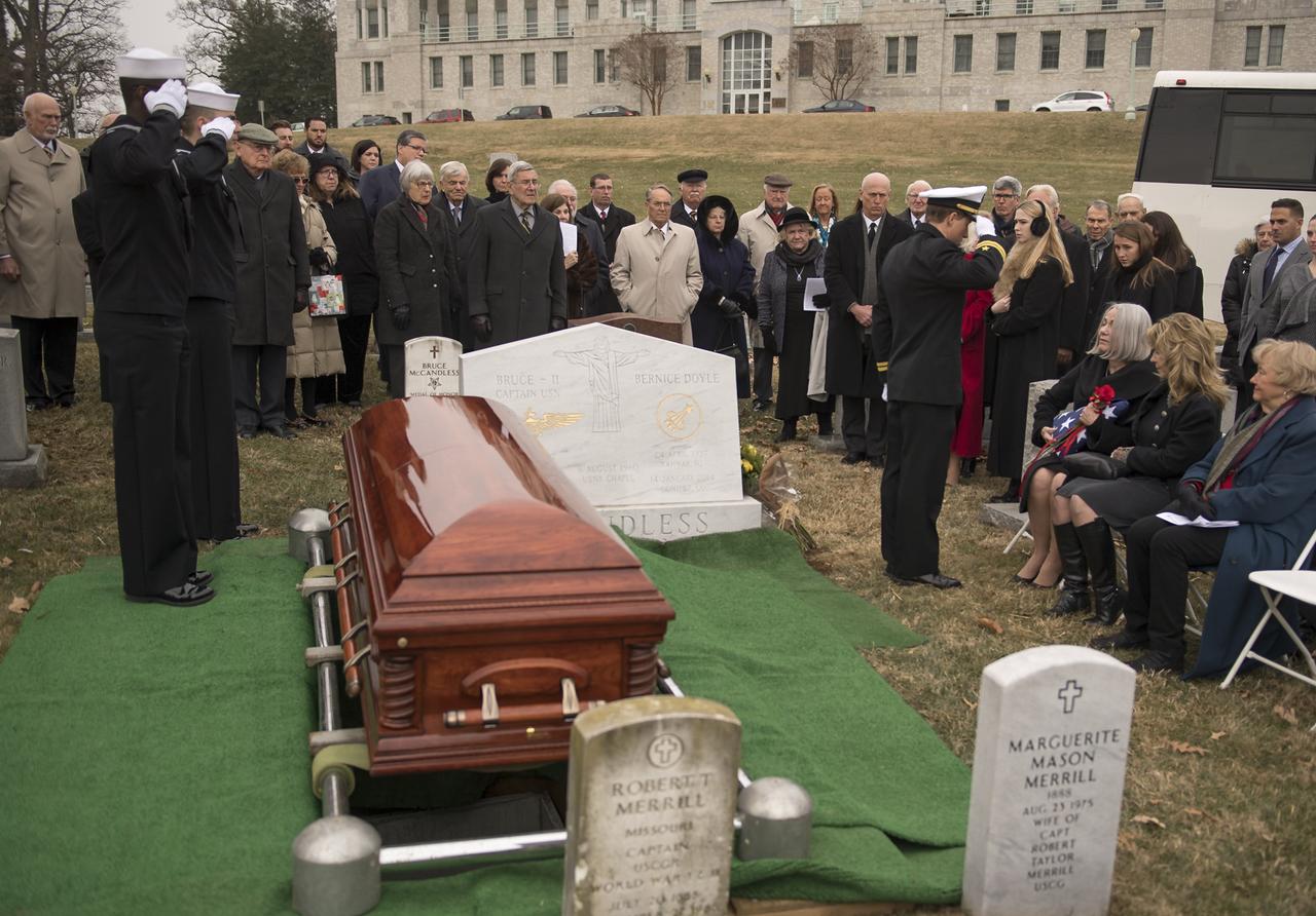
Funeral service for former NASA astronaut Captain Bruce McCandless II, USN (Ret.), Tuesday, Jan. 16, 2018 at the United States Naval Academy Cemetery in Annapolis, Maryland. Photo Credit: (NASA/Bill Ingalls)

Interment service for former NASA astronaut Captain Bruce McCandless II, USN (Ret.), Tuesday, Jan. 16, 2018 at the United States Naval Academy Cemetery in Annapolis, Maryland. Photo Credit: (NASA/Bill Ingalls)
Interment service for former NASA astronaut Captain Bruce McCandless II, USN (Ret.), Tuesday, Jan. 16, 2018 at the United States Naval Academy Cemetery in Annapolis, Maryland. Photo Credit: (NASA/Bill Ingalls)

Funeral service for former NASA astronaut Captain Bruce McCandless II, USN (Ret.), Tuesday, Jan. 16, 2018 at the United States Naval Academy Cemetery in Annapolis, Maryland. Photo Credit: (NASA/Bill Ingalls)

Funeral service for former NASA astronaut Captain Bruce McCandless II, USN (Ret.), Tuesday, Jan. 16, 2018 at the United States Naval Academy Cemetery in Annapolis, Maryland. Photo Credit: (NASA/Bill Ingalls)
A combination of the day-night band and high resolution infrared imagery from the NASA-NOAA's Suomi NPP satellite showed the record-setting winter storm along the Mid-Atlantic and the northeastern U.S. at 06:55 UTC (1:55 a.m. EST) on January 24, 2016. Read more: <a href="http://www.nasa.gov/feature/goddard/2016/nasa-sees-major-winter-storm-headed-for-eastern-us" rel="nofollow">www.nasa.gov/feature/goddard/2016/nasa-sees-major-winter-...</a> Image Credit: NOAA/NASA <b><a href="http://www.nasa.gov/audience/formedia/features/MP_Photo_Guidelines.html" rel="nofollow">NASA image use policy.</a></b> <b><a href="http://www.nasa.gov/centers/goddard/home/index.html" rel="nofollow">NASA Goddard Space Flight Center</a></b> enables NASA’s mission through four scientific endeavors: Earth Science, Heliophysics, Solar System Exploration, and Astrophysics. Goddard plays a leading role in NASA’s accomplishments by contributing compelling scientific knowledge to advance the Agency’s mission. <b>Follow us on <a href="http://twitter.com/NASAGoddardPix" rel="nofollow">Twitter</a></b> <b>Like us on <a href="http://www.facebook.com/pages/Greenbelt-MD/NASA-Goddard/395013845897?ref=tsd" rel="nofollow">Facebook</a></b> <b>Find us on <a href="http://instagrid.me/nasagoddard/?vm=grid" rel="nofollow">Instagram</a></b>

Bruce McCandless III gives remarks during the funeral service for his father, former NASA astronaut Captain Bruce McCandless II, USN (Ret.), Tuesday, Jan. 16, 2018 at the United States Naval Academy Chapel in Annapolis, Maryland. Photo Credit: (NASA/Bill Ingalls)

Bruce McCandless III gives remarks during the funeral service for his father, former NASA astronaut Captain Bruce McCandless II, USN (Ret.), Tuesday, Jan. 16, 2018 at the United States Naval Academy Chapel in Annapolis, Maryland. Photo Credit: (NASA/Bill Ingalls)

Family and friends watch as the flag that draped the casket of former NASA astronaut Captain Bruce McCandless II, USN (Ret.) is folded during his interment service, Tuesday, Jan. 16, 2018 at the United States Naval Academy Cemetery in Annapolis, Maryland. Photo Credit: (NASA/Bill Ingalls)

Ellen Shields McCandless, wife of former NASA astronaut Captain Bruce McCandless II, USN (Ret.), left, is seen during her husband's interment service, Tuesday, Jan. 16, 2018 at the United States Naval Academy Cemetery in Annapolis, Maryland. Photo Credit: (NASA/Bill Ingalls)

The flag that draped the casket of former NASA astronaut Captain Bruce McCandless II, USN (Ret.) is folded during his interment service, Tuesday, Jan. 16, 2018 at the United States Naval Academy Cemetery in Annapolis, Maryland. Photo Credit: (NASA/Bill Ingalls)

Chaplain McGrath over sees the funeral service for former NASA astronaut Captain Bruce McCandless II, USN (Ret.), Tuesday, Jan. 16, 2018 at the United States Naval Academy Chapel in Annapolis, Maryland. Photo Credit: (NASA/Bill Ingalls)

The Rev. Mark Anderson talks during the funeral service for former NASA astronaut Captain Bruce McCandless II, USN (Ret.), Tuesday, Jan. 16, 2018 at the United States Naval Academy Chapel in Annapolis, Maryland. Photo Credit: (NASA/Bill Ingalls)

Chaplain McGrath over sees the funeral service for former NASA astronaut Captain Bruce McCandless II, USN (Ret.), Tuesday, Jan. 16, 2018 at the United States Naval Academy Chapel in Annapolis, Maryland. Photo Credit: (NASA/Bill Ingalls)

Ellen Shields McCandless, wife of former NASA astronaut Captain Bruce McCandless II, USN (Ret.), left, pays her respects during her husband's interment service, Tuesday, Jan. 16, 2018 at the United States Naval Academy Cemetery in Annapolis, Maryland. Photo Credit: (NASA/Bill Ingalls)

NASA Kennedy Space Center Director Robert Cabana speaks at the funeral service for former NASA astronaut Captain Bruce McCandless II, USN (Ret.), Tuesday, Jan. 16, 2018 at the United States Naval Academy Chapel in Annapolis, Maryland. Photo Credit: (NASA/Bill Ingalls)

Taps is played during the interment service for former NASA astronaut Captain Bruce McCandless II, USN (Ret.), Tuesday, Jan. 16, 2018 at the United States Naval Academy Cemetery in Annapolis, Maryland. Photo Credit: (NASA/Bill Ingalls)

Chaplain McGrath over sees the funeral service for former NASA astronaut Captain Bruce McCandless II, USN (Ret.), Tuesday, Jan. 16, 2018 at the United States Naval Academy Chapel in Annapolis, Maryland. Photo Credit: (NASA/Bill Ingalls)

NASA Kennedy Space Center Director Robert Cabana speaks at the funeral service for former NASA astronaut Captain Bruce McCandless II, USN (Ret.), Tuesday, Jan. 16, 2018 at the United States Naval Academy Chapel in Annapolis, Maryland. Photo Credit: (NASA/Bill Ingalls)
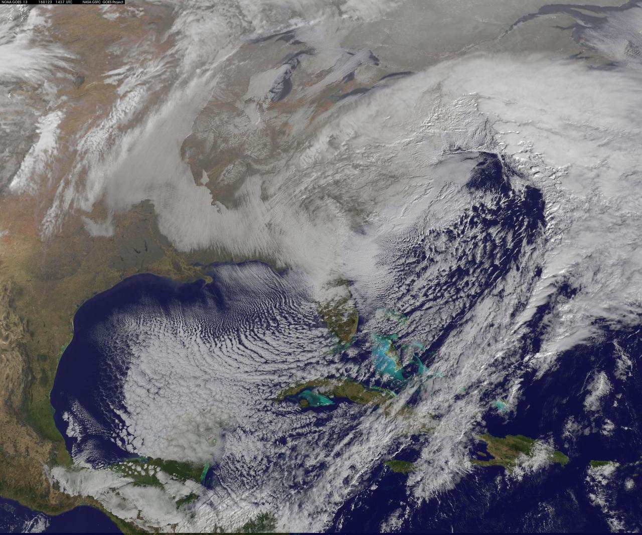
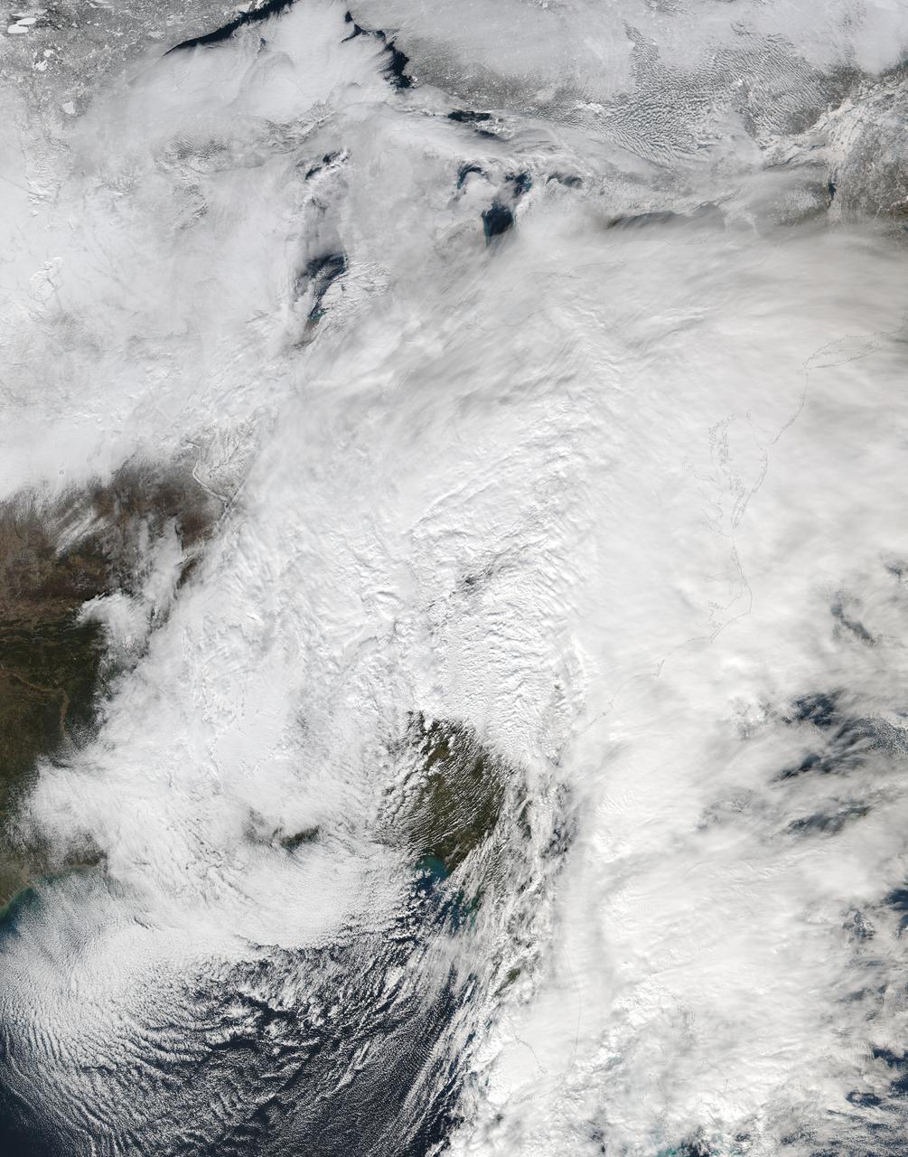
NASA satellite imagery captured the size of the massive winter storm that continued to pummel the U.S. East Coast early on January 23, 2016. This visible image of the major winter storm was taken from NOAA's GOES-East satellite on Saturday, January 23, 2016 at 1437 UTC (9:37 a.m. EST) as the Baltimore/Washington corridor was under a blizzard warning. Read more: <a href="http://go.nasa.gov/1RFv70u" rel="nofollow">go.nasa.gov/1RFv70u</a> Credits: NASA/NOAA GOES Project NASA Sees Winter Storm Slamming Eastern United States
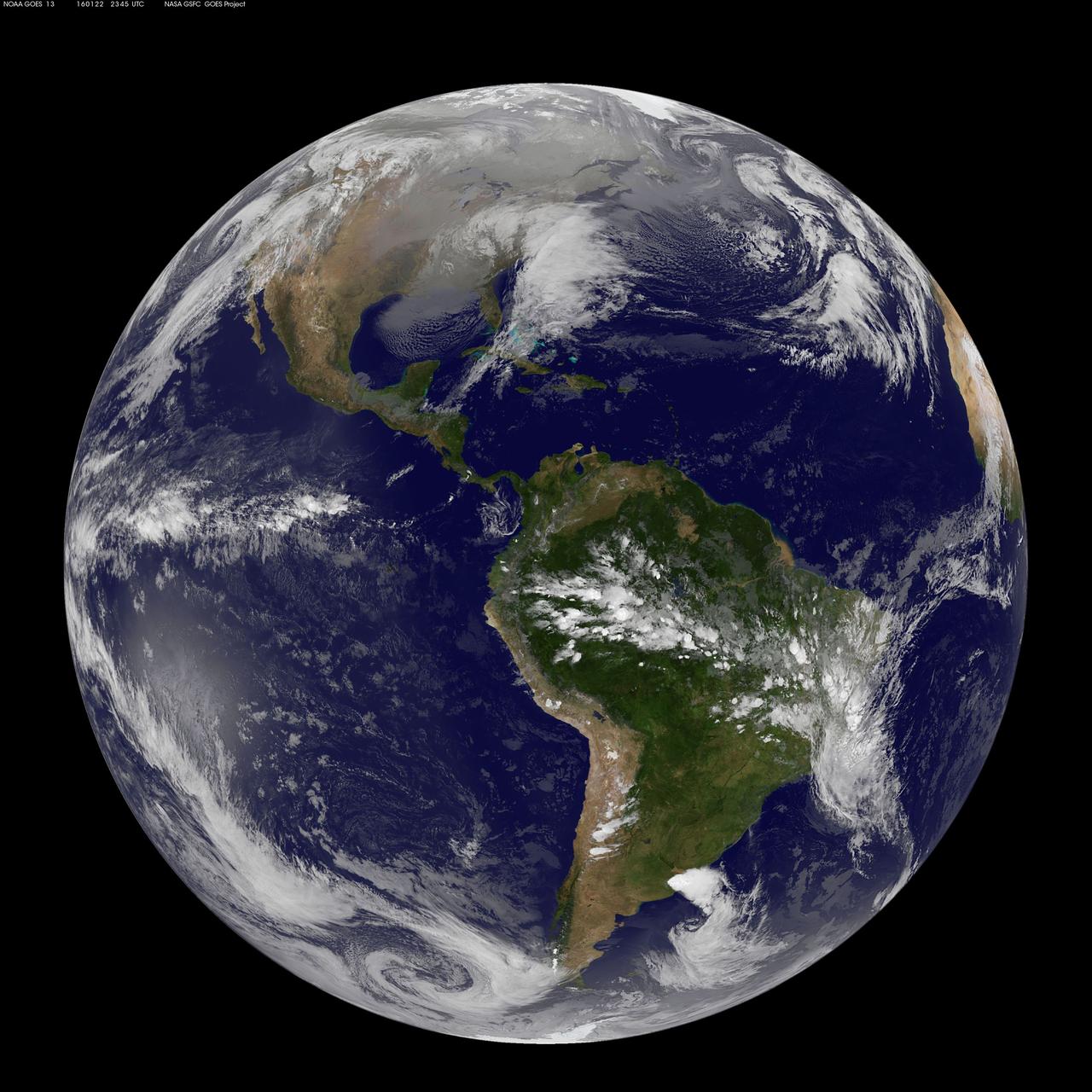
This full-disk image from the GOES-13 satellite was captured at 23:45 UTC (6:45 p.m. ET) and shows a winter blizzard blanketing the eastern United States on January 22, 2016. <b><a href="http://goes.gsfc.nasa.gov/" rel="nofollow">Credit: NOAA/NASA GOES Project</a></b> <b><a href="http://www.nasa.gov/audience/formedia/features/MP_Photo_Guidelines.html" rel="nofollow">NASA image use policy.</a></b> <b><a href="http://www.nasa.gov/centers/goddard/home/index.html" rel="nofollow">NASA Goddard Space Flight Center</a></b> enables NASA’s mission through four scientific endeavors: Earth Science, Heliophysics, Solar System Exploration, and Astrophysics. Goddard plays a leading role in NASA’s accomplishments by contributing compelling scientific knowledge to advance the Agency’s mission. <b>Follow us on <a href="http://twitter.com/NASAGoddardPix" rel="nofollow">Twitter</a></b> <b>Like us on <a href="http://www.facebook.com/pages/Greenbelt-MD/NASA-Goddard/395013845897?ref=tsd" rel="nofollow">Facebook</a></b> <b>Find us on <a href="http://instagrid.me/nasagoddard/?vm=grid" rel="nofollow">Instagram</a></b>
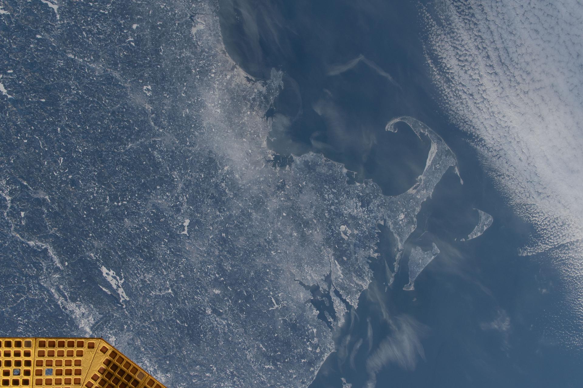
iss074e0300243 (Feb. 2, 2026) --- The wintry landscape of the southern New England region of the United States is seen from the International Space Station as it orbited 262 miles above North America. Temperatures in Boston, Massachusetts, ranged from a low of about 23 degrees Fahrenheit to a high of around 35 degrees when this photograph was taken.
Former NASA astronaut Scott Kelly speaks during an event at the United States Capitol Visitor Center, Wednesday, May 25, 2016, in Washington. Photo Credit: (NASA/Bill Ingalls)
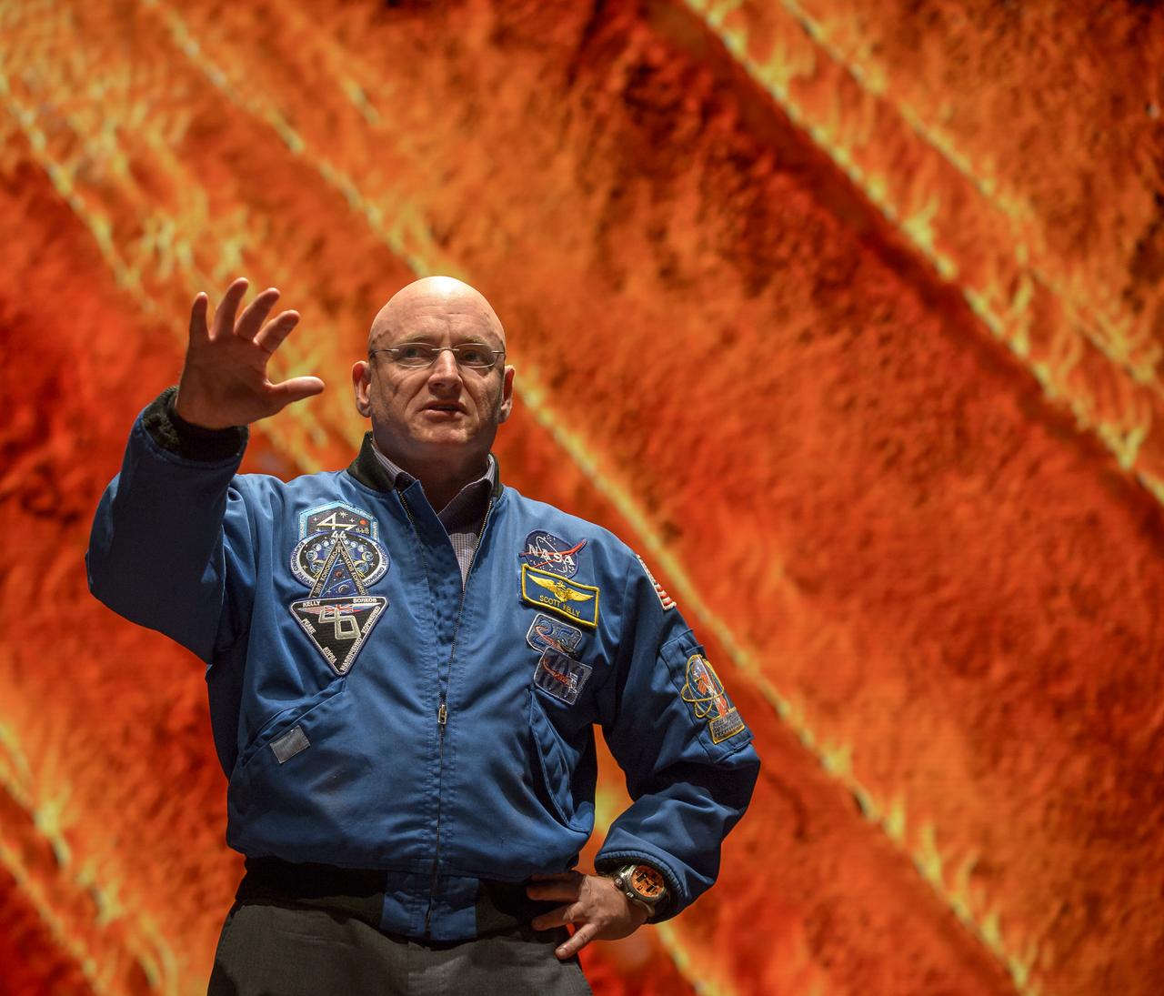
Former NASA astronaut Scott Kelly speaks during an event at the United States Capitol Visitor Center, Wednesday, May 25, 2016, in Washington. Photo Credit: (NASA/Bill Ingalls)
Former NASA astronaut Scott Kelly speaks during an event at the United States Capitol Visitor Center, Wednesday, May 25, 2016, in Washington. Photo Credit: (NASA/Bill Ingalls)
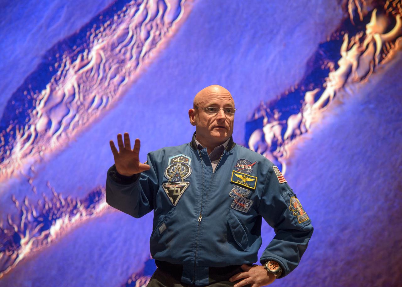
Former NASA astronaut Scott Kelly speaks during an event at the United States Capitol Visitor Center, Wednesday, May 25, 2016, in Washington. Photo Credit: (NASA/Bill Ingalls)

NASA Administrator Charles Bolden introduces former NASA astronaut Scott Kelly during an event at the United States Capitol Visitor Center, Wednesday, May 25, 2016, in Washington. Photo Credit: (NASA/Bill Ingalls)

NASA Administrator Charles Bolden introduces former NASA astronaut Scott Kelly during an event at the United States Capitol Visitor Center, Wednesday, May 25, 2016, in Washington. Photo Credit: (NASA/Bill Ingalls)
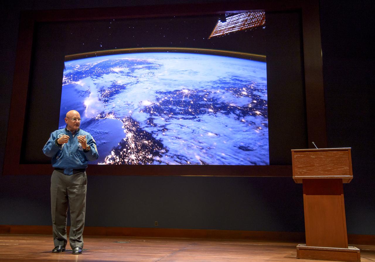
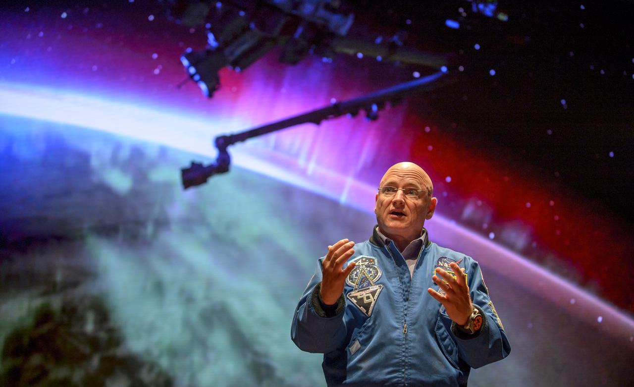
Former NASA astronaut Scott Kelly speaks during an event at the United States Capitol Visitor Center, Wednesday, May 25, 2016, in Washington. Photo Credit: (NASA/Bill Ingalls)
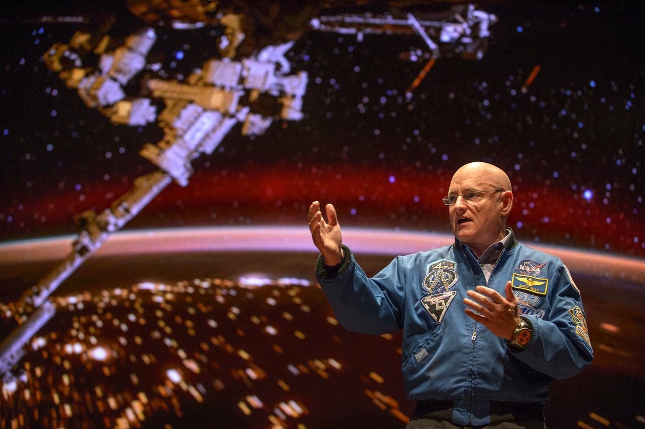
Former NASA astronaut Scott Kelly speaks during an event at the United States Capitol Visitor Center, Wednesday, May 25, 2016, in Washington. Photo Credit: (NASA/Bill Ingalls)
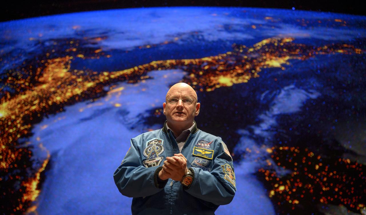
Former NASA astronaut Scott Kelly speaks during an event at the United States Capitol Visitor Center, Wednesday, May 25, 2016, in Washington. Photo Credit: (NASA/Bill Ingalls)
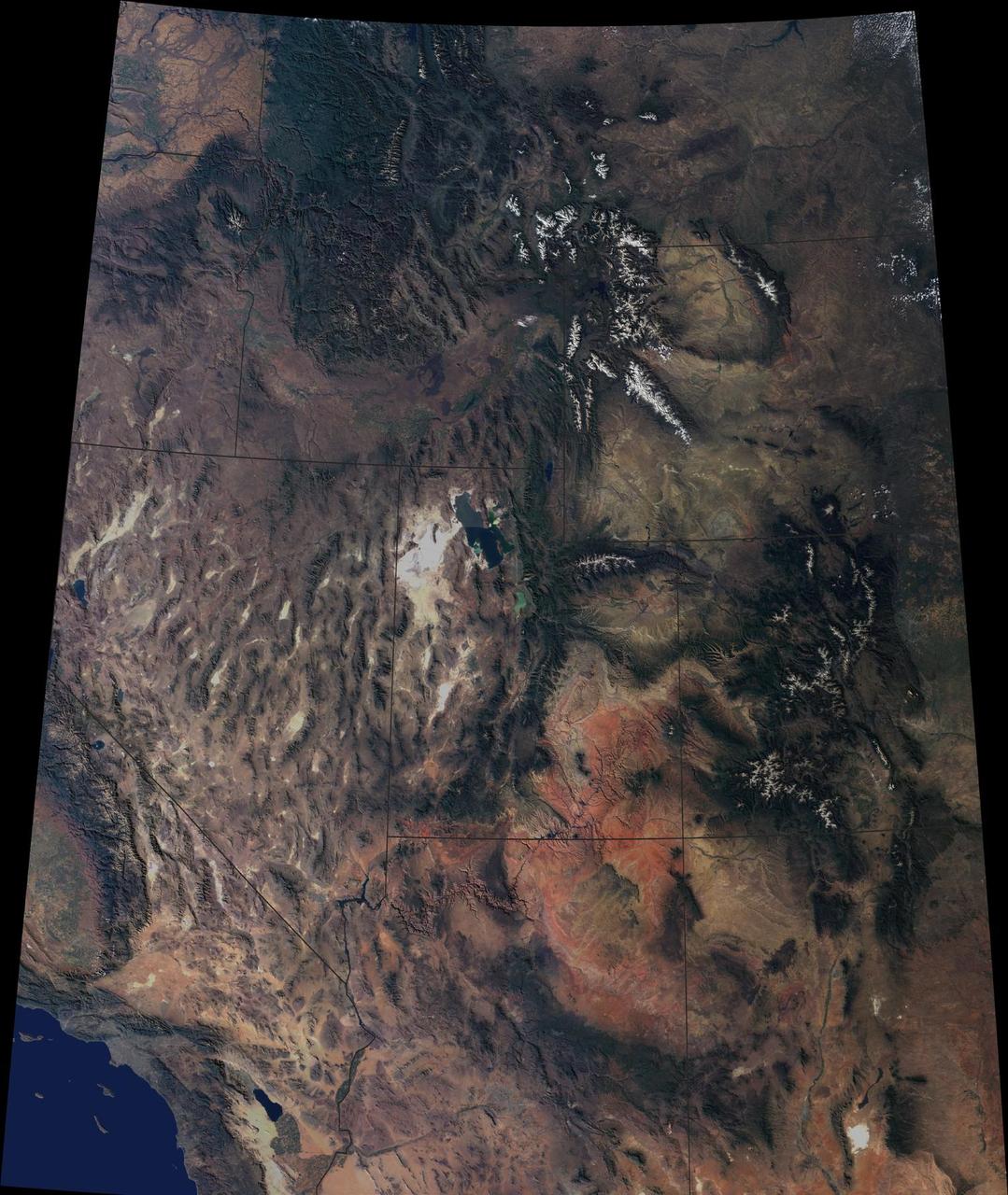
The breathtaking beauty of the western United States is apparent in this image from data acquired between April 2000 and September 2001 from the Multi-angle Imaging SpectroRadiometer on NASA Terra spacecraft.

The flag that draped the casket of former NASA astronaut Captain Bruce McCandless II, USN (Ret.) is presented to his wife Ellen Shields McCandless during his interment service, Tuesday, Jan. 16, 2018 at the United States Naval Academy Cemetery in Annapolis, Maryland. Photo Credit: (NASA/Bill Ingalls)

Former NASA Administrator Charlie Bolden speaks at the funeral service for former NASA astronaut Captain Bruce McCandless II, USN (Ret.), Tuesday, Jan. 16, 2018 at the United States Naval Academy Chapel in Annapolis, Maryland. Photo Credit: (NASA/Bill Ingalls)

Former NASA Administrator Charlie Bolden speaks at the funeral service for former NASA astronaut Captain Bruce McCandless II, USN (Ret.), Tuesday, Jan. 16, 2018 at the United States Naval Academy Chapel in Annapolis, Maryland. Photo Credit: (NASA/Bill Ingalls)
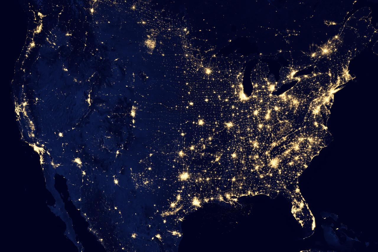
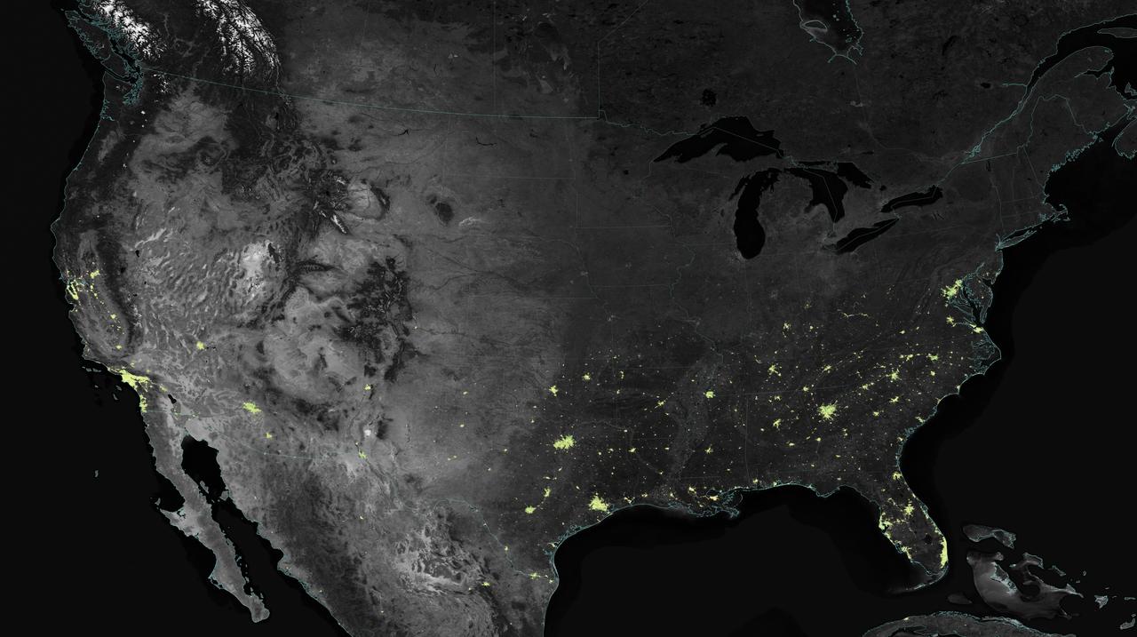
NASA image acquired April 18 - October 23, 2012 This image of the United States of America at night is a composite assembled from data acquired by the Suomi NPP satellite in April and October 2012. The image was made possible by the new satellite’s “day-night band” of the Visible Infrared Imaging Radiometer Suite (VIIRS), which detects light in a range of wavelengths from green to near-infrared and uses filtering techniques to observe dim signals such as city lights, gas flares, auroras, wildfires, and reflected moonlight. “Nighttime light is the most interesting data that I’ve had a chance to work with,” says Chris Elvidge, who leads the Earth Observation Group at NOAA’s National Geophysical Data Center. “I’m always amazed at what city light images show us about human activity.” His research group has been approached by scientists seeking to model the distribution of carbon dioxide emissions from fossil fuels and to monitor the activity of commercial fishing fleets. Biologists have examined how urban growth has fragmented animal habitat. Elvidge even learned once of a study of dictatorships in various parts of the world and how nighttime lights had a tendency to expand in the dictator’s hometown or province. Named for satellite meteorology pioneer Verner Suomi, NPP flies over any given point on Earth's surface twice each day at roughly 1:30 a.m. and p.m. The polar-orbiting satellite flies 824 kilometers (512 miles) above the surface, sending its data once per orbit to a ground station in Svalbard, Norway, and continuously to local direct broadcast users distributed around the world. Suomi NPP is managed by NASA with operational support from NOAA and its Joint Polar Satellite System, which manages the satellite's ground system. NASA Earth Observatory image by Robert Simmon, using Suomi NPP VIIRS data provided courtesy of Chris Elvidge (NOAA National Geophysical Data Center). Suomi NPP is the result of a partnership between NASA, NOAA, and the Department of Defense. Caption by Mike Carlowicz. Instrument: Suomi NPP - VIIRS Credit: <b><a href="http://www.earthobservatory.nasa.gov/" rel="nofollow"> NASA Earth Observatory</a></b> <b>Click here to view all of the <a href="http://earthobservatory.nasa.gov/Features/NightLights/" rel="nofollow"> Earth at Night 2012 images </a></b> <b>Click here to <a href="http://earthobservatory.nasa.gov/NaturalHazards/view.php?id=79800" rel="nofollow"> read more </a> about this image </b> <b><a href="http://www.nasa.gov/audience/formedia/features/MP_Photo_Guidelines.html" rel="nofollow">NASA image use policy.</a></b> <b><a href="http://www.nasa.gov/centers/goddard/home/index.html" rel="nofollow">NASA Goddard Space Flight Center</a></b> enables NASA’s mission through four scientific endeavors: Earth Science, Heliophysics, Solar System Exploration, and Astrophysics. Goddard plays a leading role in NASA’s accomplishments by contributing compelling scientific knowledge to advance the Agency’s mission. <b>Follow us on <a href="http://twitter.com/NASA_GoddardPix" rel="nofollow">Twitter</a></b> <b>Like us on <a href="http://www.facebook.com/pages/Greenbelt-MD/NASA-Goddard/395013845897?ref=tsd" rel="nofollow">Facebook</a></b> <b>Find us on <a href="http://instagram.com/nasagoddard?vm=grid" rel="nofollow">Instagram</a></b>
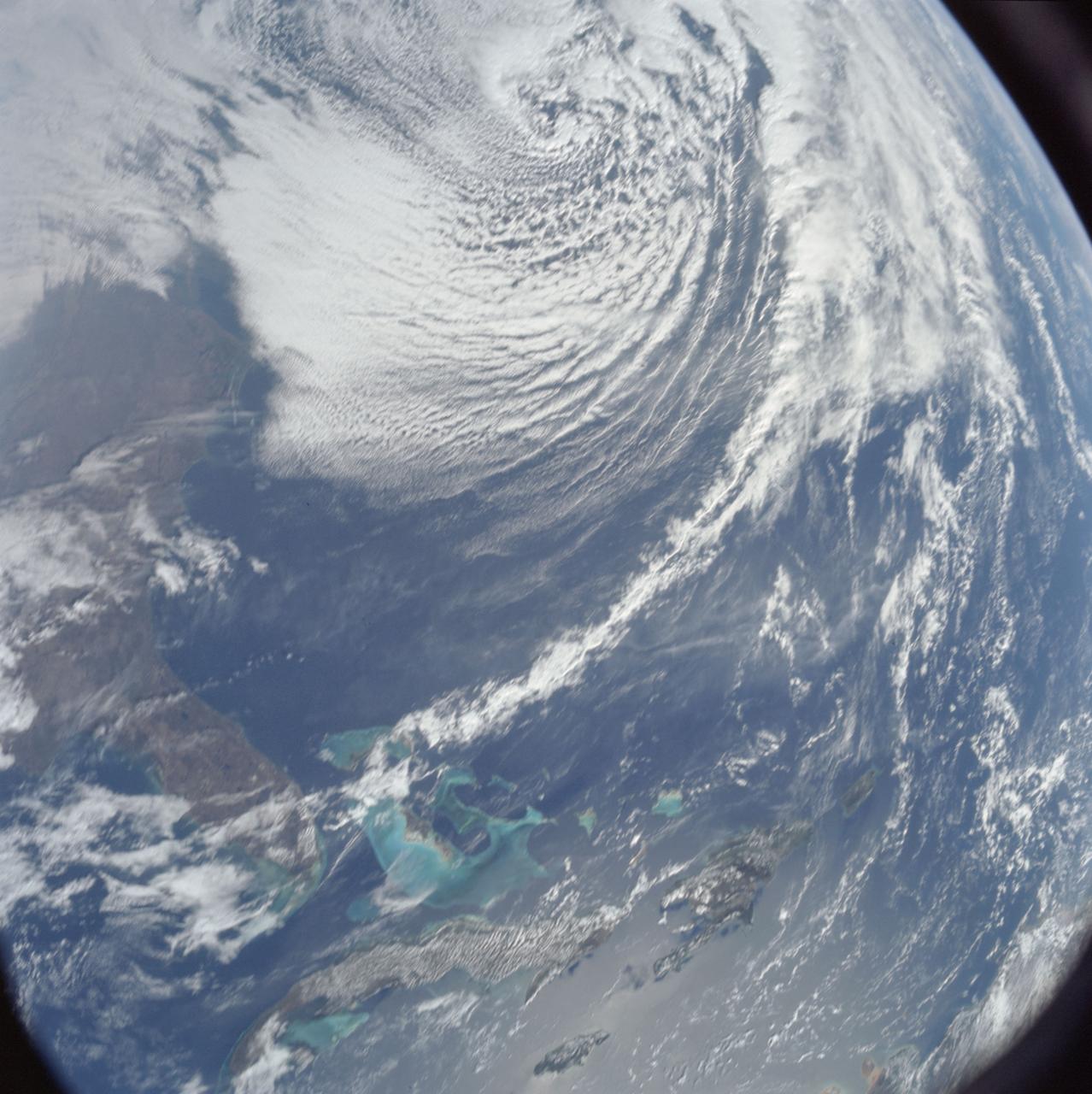
AS08-16-2581 (21-27 Dec. 1968) --- This photograph of Earth was taken from the Apollo 8 spacecraft while it was in Earth orbit. Most of the southeastern United States and the Caribbean Sea area, the U.S. coastline from Chesapeake Bay to the Florida Peninsula can be seen. The Bahamas and the islands of Cuba, Jamaica, Hispaniola and Puerto Rico extend across the Caribbean, the light blue of the shallow Bahama banks contrasting sharply with the darker hue of the deeper water, especially in the Tongue of the Ocean area.
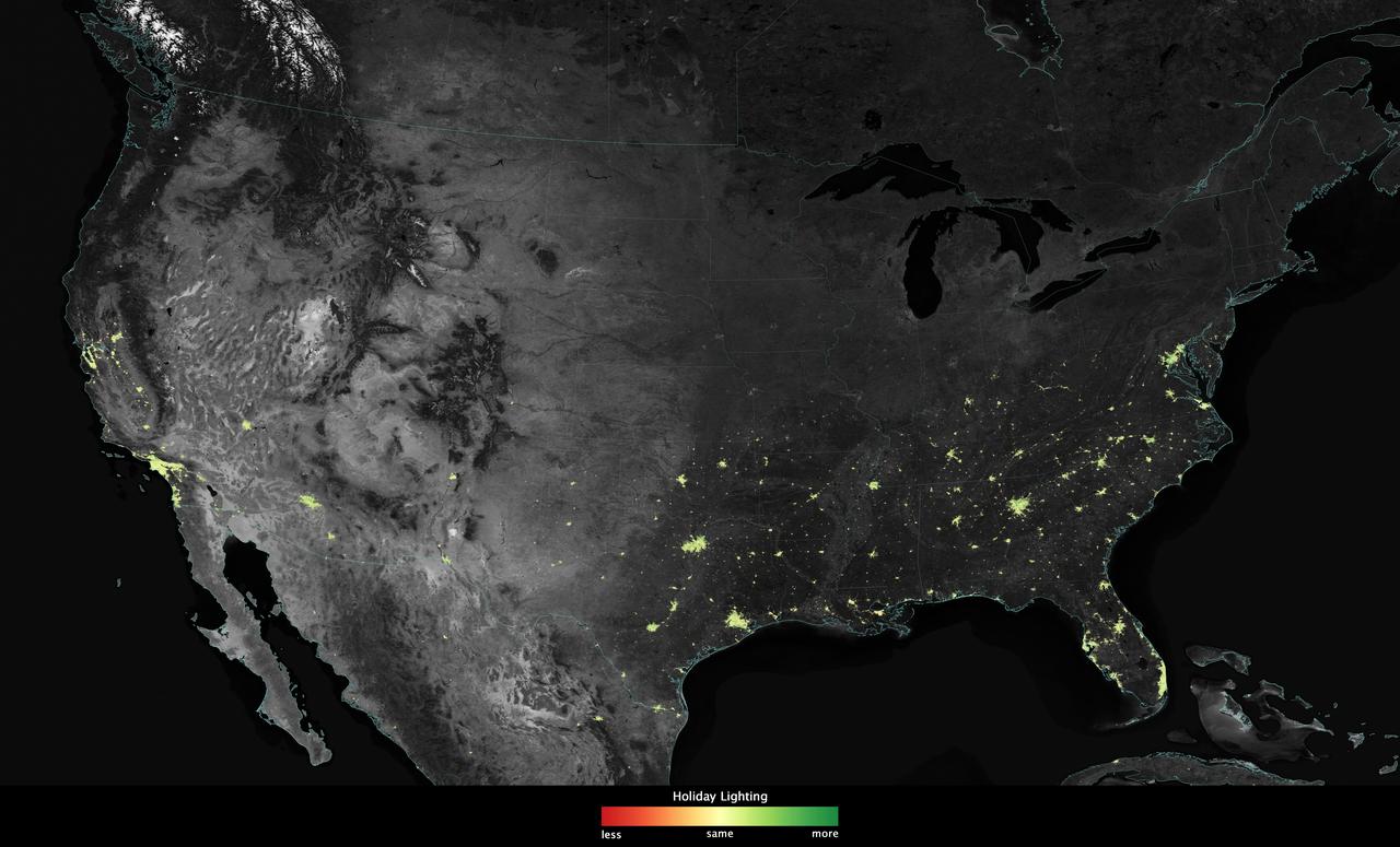
City lights shine brighter during the holidays in the United States when compared with the rest of the year, as shown using a new analysis of daily data from the NASA-NOAA Suomi NPP satellite. Dark green pixels are areas where lights are 50 percent brighter, or more, during December. Because snow reflects so much light, the researchers could only analyze snow-free cities. They focused on the U.S. West Coast from San Francisco and Los Angeles, and cities south of a rough imaginary line from St. Louis to Washington, D.C. Credit: Jesse Allen, NASA’s Earth Observatory Read more: <a href="http://www.nasa.gov/content/goddard/satellite-sees-holiday-lights-brighten-cities" rel="nofollow">www.nasa.gov/content/goddard/satellite-sees-holiday-light...</a> <b><a href="http://www.nasa.gov/audience/formedia/features/MP_Photo_Guidelines.html" rel="nofollow">NASA image use policy.</a></b> <b><a href="http://www.nasa.gov/centers/goddard/home/index.html" rel="nofollow">NASA Goddard Space Flight Center</a></b> enables NASA’s mission through four scientific endeavors: Earth Science, Heliophysics, Solar System Exploration, and Astrophysics. Goddard plays a leading role in NASA’s accomplishments by contributing compelling scientific knowledge to advance the Agency’s mission. <b>Follow us on <a href="http://twitter.com/NASAGoddardPix" rel="nofollow">Twitter</a></b> <b>Like us on <a href="http://www.facebook.com/pages/Greenbelt-MD/NASA-Goddard/395013845897?ref=tsd" rel="nofollow">Facebook</a></b> <b>Find us on <a href="http://instagram.com/nasagoddard?vm=grid" rel="nofollow">Instagram</a></b>
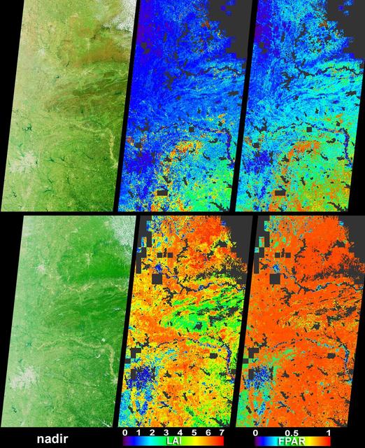
Vigorous vegetation growth in the Southern United States after heavy rains fell during April and early May, 2004, is quantified in these images and data products from NASA Terra spacecraft.
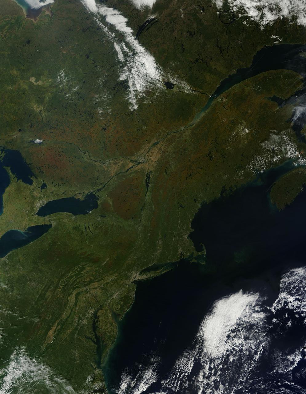
As temperatures dropped and daylight began to shorten, autumn colors began to wash over the deciduous forests of North America. The Moderate Resolution Imaging Spectroradiometer (MODIS) aboard NASA’s Terra satellite captured this true-color image of the northeastern United States and Canada on September 27, 2014. Washes of orange, brown and yellow are brightest in the Upper Peninsula of Michigan, upstate New York, New Hampshire, Vermont, Maine, and southern Quebec and Ontario. Also, faint traces of phytoplankton blooms can be seen in the offshore waters of the Atlantic Ocean. The transition of autumn leaves from green, to glowing with colors, to browning and dropping to the ground, involve several complex interactions and reactions. However, length of sunlight and the temperature changes are dominant factors. Topography also plays a role, as does latitude. Temperature tends to drop faster at higher elevations and at higher latitudes, and day length shortens more quickly at higher latitudes. Color change tends to begin in the north and sweep southward, and change begins at mountain tops then moves into valleys. As explained by the U.S. Forest Service, certain species of trees produce certain colors. Oaks generally turn red, brown, or russet; hickories become golden bronze; aspen and yellow-poplar turn golden. Maples differ by species. Red maple turns brilliant scarlet; sugar maple, orange-red; and black maple, yellow. Leaves of some trees, such as elms, simply become brown. Credit: NASA/GSFC/Jeff Schmaltz/MODIS Land Rapid Response Team <b><a href="http://www.nasa.gov/audience/formedia/features/MP_Photo_Guidelines.html" rel="nofollow">NASA image use policy.</a></b> <b><a href="http://www.nasa.gov/centers/goddard/home/index.html" rel="nofollow">NASA Goddard Space Flight Center</a></b> enables NASA’s mission through four scientific endeavors: Earth Science, Heliophysics, Solar System Exploration, and Astrophysics. Goddard plays a leading role in NASA’s accomplishments by contributing compelling scientific knowledge to advance the Agency’s mission. <b>Follow us on <a href="http://twitter.com/NASAGoddardPix" rel="nofollow">Twitter</a></b> <b>Like us on <a href="http://www.facebook.com/pages/Greenbelt-MD/NASA-Goddard/395013845897?ref=tsd" rel="nofollow">Facebook</a></b> <b>Find us on <a href="http://instagram.com/nasagoddard?vm=grid" rel="nofollow">Instagram</a></b>
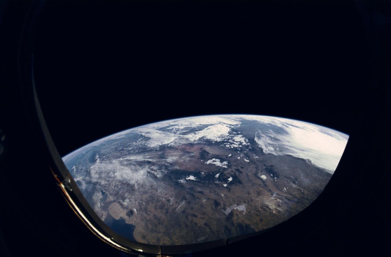
STS-31 Earth observation taken aboard Discovery, Orbiter Vehicle (OV) 103, is of the western United States with the Salton Sea and Imperial Valley area recognizable at the lower left. The view is framed in a flight deck window and was photographed using a fish-eye lens.
iss072e715420 (March 2, 2025) --- This long-duration photograph looks out a window on the SpaceX Dragon crew spacecraft and down the eastern coast of the United States at approximately 12:34 a.m. local time as the International Space Station orbited 264 miles above Newfoundland, Canada.
AS6-02-1485 (4 April 1968) --- View of the east coast of the United States as photographed from the National Aeronautics and Space Administration's unmanned Apollo 6 (Spacecraft 020/Saturn 502) space mission. This photograph was taken during a pass over Georgia, between Savannah and Brunswick. Altitude of the spacecraft was 100 nautical miles. Numerous jet aircraft contrails can be seen over the Atlantic Ocean. Sun glint on the surface of the ocean permits oceanographers to determine conditions of the water. This photograph was taken April 4, 1968, three hours and 14 minutes after liftoff, using Eastman Kodak SO-121 high resolution aerial Ektachrome film (exposure setting f/5.6 at 1/500 second), in a J. A. Maurer model 220G camera.
iss072e891004 (March 22, 2025) --- The Florida peninsula and the eastern coast of the United States, including the Bahamas in the Atlantic Ocean, are pictured at 1:37 a.m. local time from the International Space Station as it orbited 260 miles above.
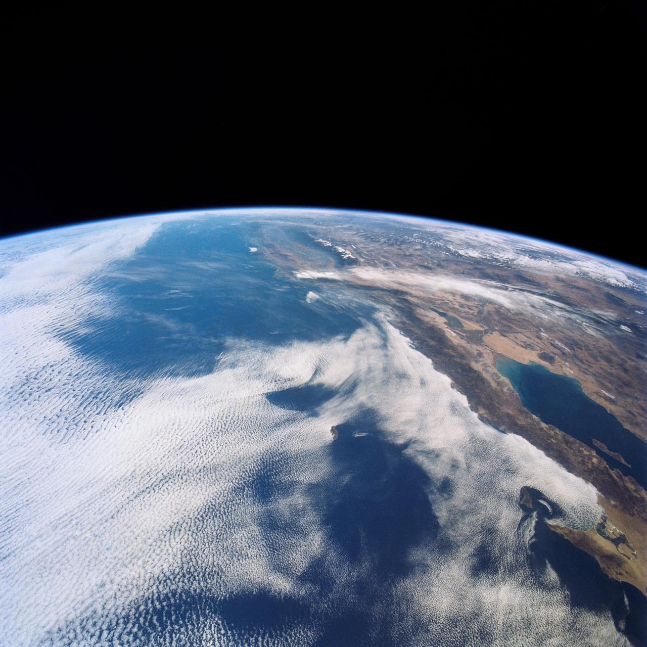
This view shows the west coast of the United States and Mexico (32.5N, 118.0W) and gives an indication of the range of view from orbital altitude. The visual range of this particular scene is from Skammon's Lagoon on Baja to the northern tip of California's Central Valley and Sierra Nevada, a range of over 15 degrees of latitude. Coastal fog drapes over southern California and northern Baja California. White Sands, New Mexico is at far right center.
iss072e186812 (Nov. 14, 2024) --- The city lights along the New England coast of the United States including New Haven, Connecticut; Providence, Rhode Island; and Boston, Massachusetts, are pictured from the United States as it orbited 254 miles above the Atlantic Ocean.
iss072e629084 (Feb. 14, 2025) --- The east coast of the United States from Massachussetts to Georgia, with the easily distinguishable Delaware Bay and Chesapeake Bay, contrasts with the gleaming Atlantic Ocean in this photograph from the International Space Station as it orbited 263 miles above North America.
iss073e0149171 (May 21, 2025) --- City lights dot the southern United States' landscape from Louisiana (upper left), to Florida (lower center), to South Carolina (right), in this photograph from the International Space Station as it orbited 260 miles above Georgia at approximately 12:59 a.m. local time.
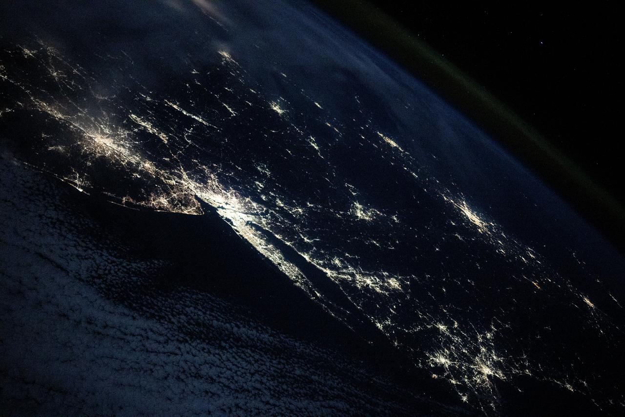
iss072e186819 (Nov. 14, 2024) --- The city lights of the United States' eastern seaboard from Philadelphia, Pennsylvania; to New York City; to Boston, Massachusetts; as well as Montreal, Quebec, in Canada (right center), are pictured from the International Space Station as it orbited 254 miles above the Atlantic Ocean.
STS058-102-018 (18 Oct-1 Nov 1993) --- A cloud-free, wide-angle view from above western Tennessee to the northern edge of Lake Michigan. The view extends from Saint Louis, Missouri near the lower left-hand corner, past Evansville, Indiana and Louisville, Kentucky to Cincinnati, Ohio. A range of hills covered by trees in Fall foliage extends from the Ohio River toward Lake Michigan, ending just southwest of Indianapolis, Indiana.
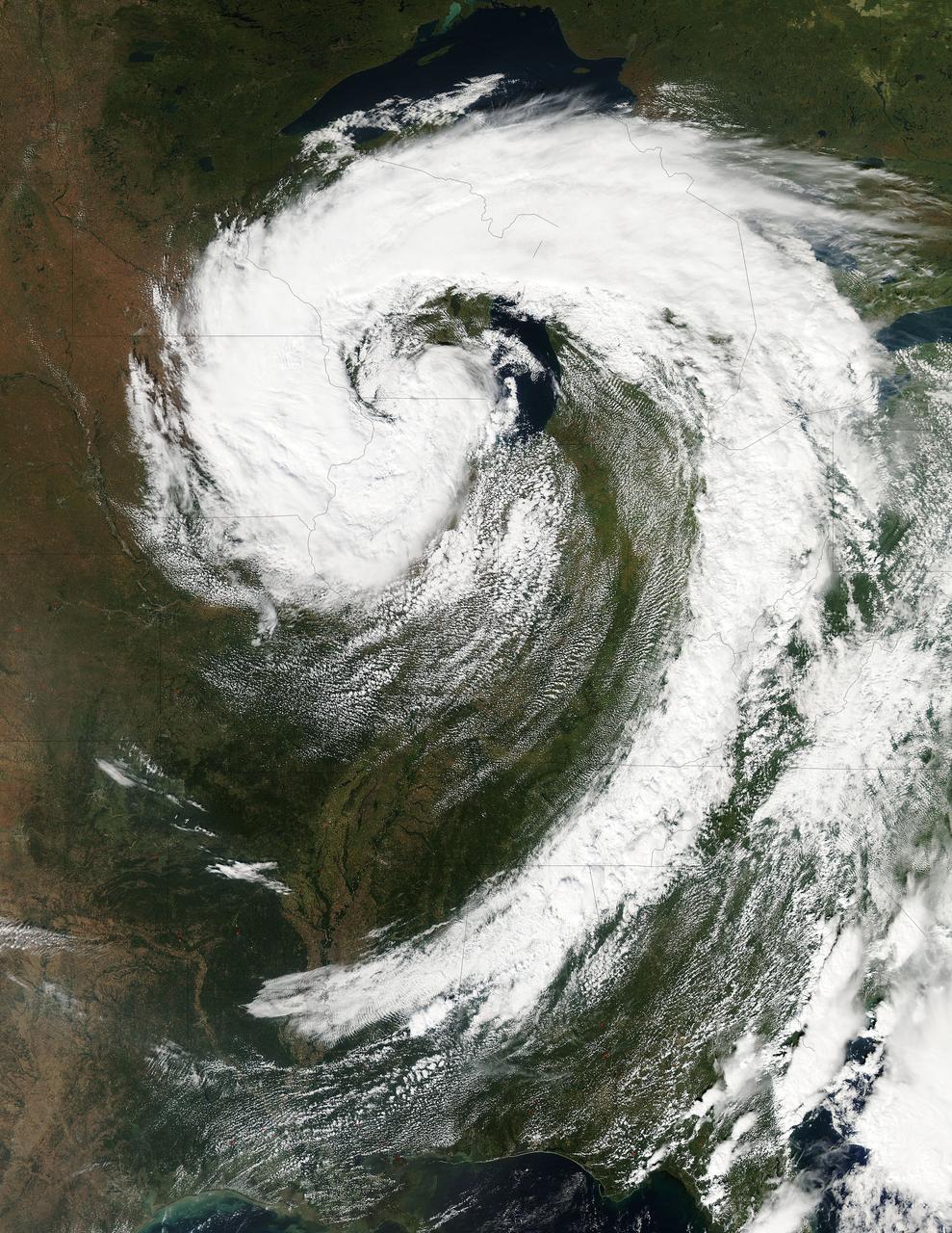
This visible image of the Great Lakes low pressure area was taken from the Moderate Resolution Imaging Spectroradiometer (MODIS) instrument on NASA's Aqua satellite. It was taken at 19:05 UTC (3:05 p.m. EDT) on Monday, Sept. 26, 2011. Credit: NASA Goddard MODIS Rapid Response Team Two Instruments on NASA's Aqua Satellite Catch the Pesky Great Lakes Low A low pressure area has been sitting over the Great Lakes region for about a week now, keeping the region and the U.S. northeast and Mid-Atlantic under cloud cover. NASA's Aqua satellite flew over head yesterday, Sept. 26, and captured two views of it from space. That low pressure area continues to spin counter-clockwise today over the Great Lakes. Its centered over northern Illinois and southeastern Wisconsin and is once again going to keep the region cloudy, cool and wet with showers. When the Aqua satellite passed overhead Monday afternoon at 3:05 p.m. EDT (Sept. 26) a detailed, clear image was captured from the Moderate Resolution Imaging Spectroradiometer (MODIS) instrument . The clouds from the low spread over Illinois, Wisconsin, parts of Iowa, northeastern Missouri, southeastern Minnesota, Michigan, Ohio, Indiana, Pennsylvania, Kentucky, Tennessee, Alabama, Mississippi, Georgia, and the northeastern and Mid-Atlantic states. A second visible image was captured by the Atmospheric Infrared Sounder (AIRS) instrument that also flies aboard NASA's Aqua satellite and showed the huge comma shape of the storm that spans the U.S. from its northern to southern borders. (seen here: <a href="http://www.flickr.com/photos/gsfc/6188946564">www.flickr.com/photos/gsfc/6188946564</a> ) According to the National Weather Service, the low will finally start moving to the east as an upper-atmospheric trough (an elongated area of low pressure) continues to strengthen and move into the upper Midwest. However, a ridge (elongated area) of high pressure will slow its move eastward, so it will be slow clearing this week in the northeastern and Mid-Atlantic U.S. Rob Gutro NASA's Goddard Space Flight Center <b><a href="http://www.nasa.gov/audience/formedia/features/MP_Photo_Guidelines.html" rel="nofollow">NASA image use policy.</a></b> <b><a href="http://www.nasa.gov/centers/goddard/home/index.html" rel="nofollow">NASA Goddard Space Flight Center</a></b> enables NASA’s mission through four scientific endeavors: Earth Science, Heliophysics, Solar System Exploration, and Astrophysics. Goddard plays a leading role in NASA’s accomplishments by contributing compelling scientific knowledge to advance the Agency’s mission. <b>Follow us on <a href="http://twitter.com/NASA_GoddardPix" rel="nofollow">Twitter</a></b> <b>Like us on <a href="http://www.facebook.com/pages/Greenbelt-MD/NASA-Goddard/395013845897?ref=tsd" rel="nofollow">Facebook</a></b> <b>Find us on <a href="http://instagrid.me/nasagoddard/?vm=grid" rel="nofollow">Instagram</a></b>
NASA-NOAA's Suomi NPP satellite passed over the large low pressure area on January 22 at 1855 UTC (1:55 p.m. EST) that stretched from New England south to Florida. Credit: Credits: NASA/NOAA/Goddard Rapid Response Team Credit: NASA/Goddard/Suomi NPP/VIIRS <b><a href="http://www.nasa.gov/audience/formedia/features/MP_Photo_Guidelines.html" rel="nofollow">NASA image use policy.</a></b> <b><a href="http://www.nasa.gov/centers/goddard/home/index.html" rel="nofollow">NASA Goddard Space Flight Center</a></b> enables NASA’s mission through four scientific endeavors: Earth Science, Heliophysics, Solar System Exploration, and Astrophysics. Goddard plays a leading role in NASA’s accomplishments by contributing compelling scientific knowledge to advance the Agency’s mission. <b>Follow us on <a href="http://twitter.com/NASAGoddardPix" rel="nofollow">Twitter</a></b> <b>Like us on <a href="http://www.facebook.com/pages/Greenbelt-MD/NASA-Goddard/395013845897?ref=tsd" rel="nofollow">Facebook</a></b> <b>Find us on <a href="http://instagrid.me/nasagoddard/?vm=grid" rel="nofollow">Instagram</a></b>
City lights shine brighter during the holidays in the United States when compared with the rest of the year, as shown using a new analysis of daily data from the NASA-NOAA Suomi NPP satellite. Dark green pixels are areas where lights are 50 percent brighter, or more, during December. Because snow reflects so much light, the researchers could only analyze snow-free cities. They focused on the U.S. West Coast from San Francisco and Los Angeles, and cities south of a rough imaginary line from St. Louis to Washington, D.C. Credit: Jesse Allen, NASA’s Earth Observatory Read more: <a href="http://www.nasa.gov/content/goddard/satellite-sees-holiday-lights-brighten-cities." rel="nofollow">www.nasa.gov/content/goddard/satellite-sees-holiday-light...</a>.<b><a href="http://www.nasa.gov/audience/formedia/features/MP_Photo_Guidelines.html" rel="nofollow">NASA image use policy.</a></b> <b><a href="http://www.nasa.gov/centers/goddard/home/index.html" rel="nofollow">NASA Goddard Space Flight Center</a></b> enables NASA’s mission through four scientific endeavors: Earth Science, Heliophysics, Solar System Exploration, and Astrophysics. Goddard plays a leading role in NASA’s accomplishments by contributing compelling scientific knowledge to advance the Agency’s mission. <b>Follow us on <a href="http://twitter.com/NASAGoddardPix" rel="nofollow">Twitter</a></b> <b>Like us on <a href="http://www.facebook.com/pages/Greenbelt-MD/NASA-Goddard/395013845897?ref=tsd" rel="nofollow">Facebook</a></b> <b>Find us on <a href="http://instagram.com/nasagoddard?vm=grid" rel="nofollow">Instagram</a></b>

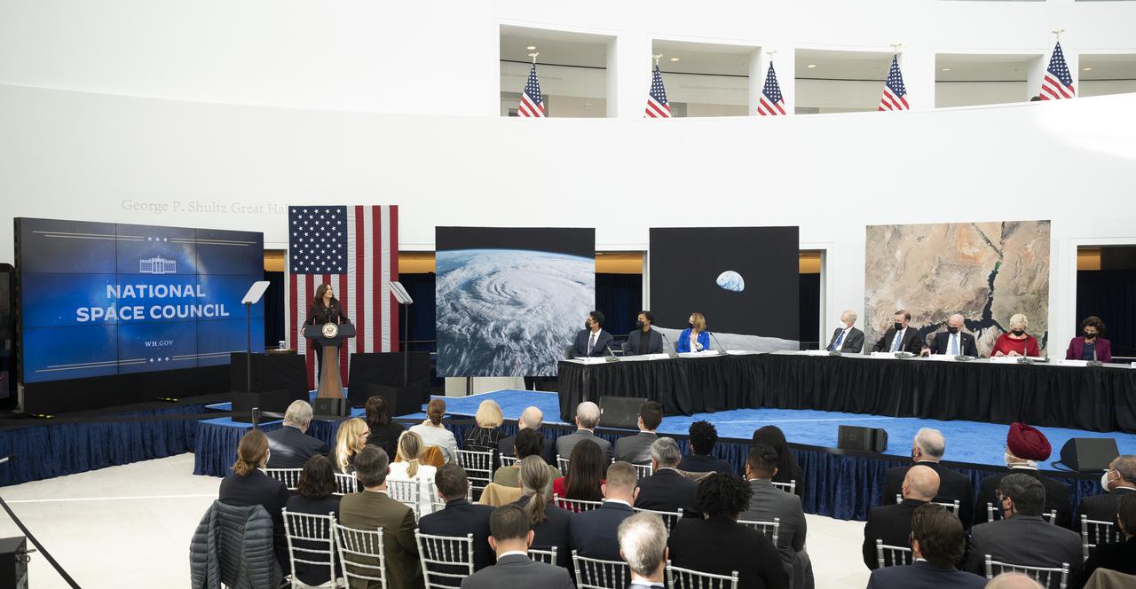
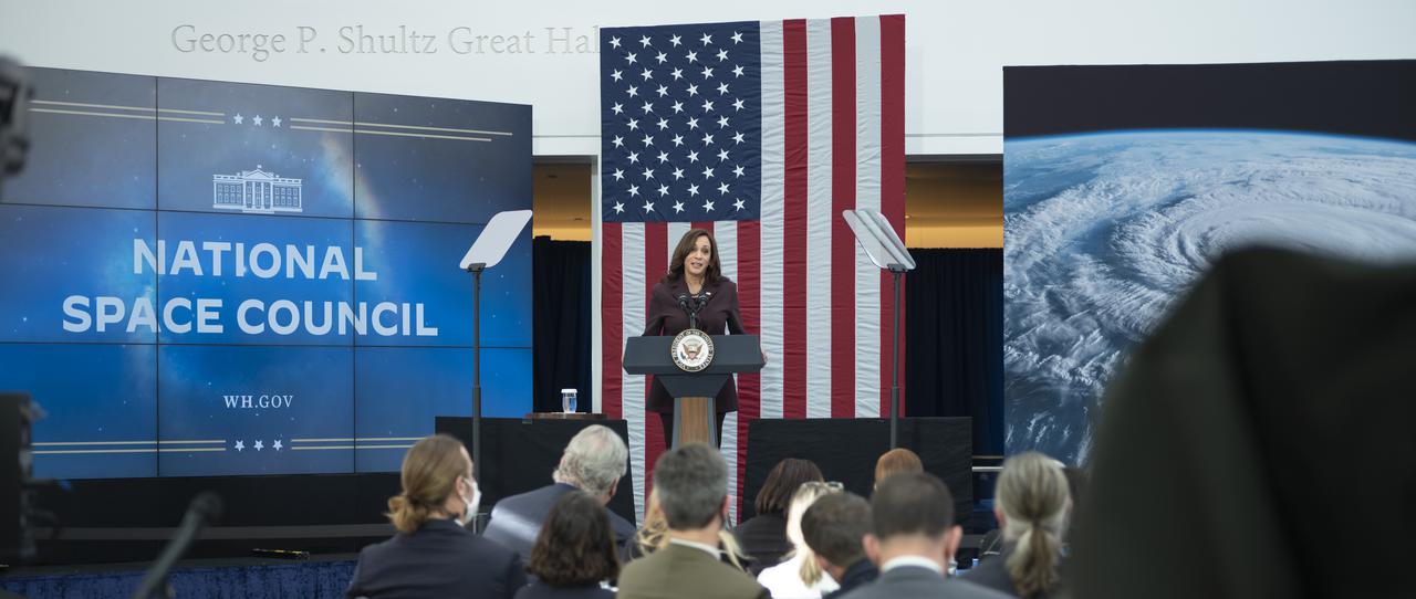
Vice President Kamala Harris is seen during the National Space Council’s first meeting, Wednesday, Dec. 1, 2021 at the United States Institute of Peace in Washington. Chaired by Vice President Harris, the council's role is to advise the President regarding national space policy and strategy, and ensuring the United States capitalizes on the opportunities presented by the country’s space activities. Photo Credit: (NASA/Joel Kowsky)

Vice President Kamala Harris delivers opening remarks at the first meeting of the National Space Council, Wednesday, Dec. 1, 2021, at the United States Institute of Peace in Washington. Chaired by Vice President Harris, the council's role is to advise the President regarding national space policy and strategy, and ensuring the United States capitalizes on the opportunities presented by the country’s space activities. Photo Credit: (NASA/Joel Kowsky)
Vice President Kamala Harris delivers opening remarks at the first meeting of the National Space Council, Wednesday, Dec. 1, 2021, at the United States Institute of Peace in Washington. Chaired by Vice President Harris, the council's role is to advise the President regarding national space policy and strategy, and ensuring the United States capitalizes on the opportunities presented by the country’s space activities. Photo Credit: (NASA/Joel Kowsky)

Vice President Kamala Harris delivers opening remarks at the first meeting of the National Space Council, Wednesday, Dec. 1, 2021, at the United States Institute of Peace in Washington. Chaired by Vice President Harris, the council's role is to advise the President regarding national space policy and strategy, and ensuring the United States capitalizes on the opportunities presented by the country’s space activities. Photo Credit: (NASA/Joel Kowsky)
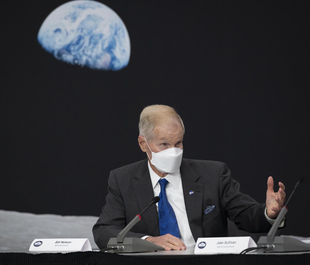
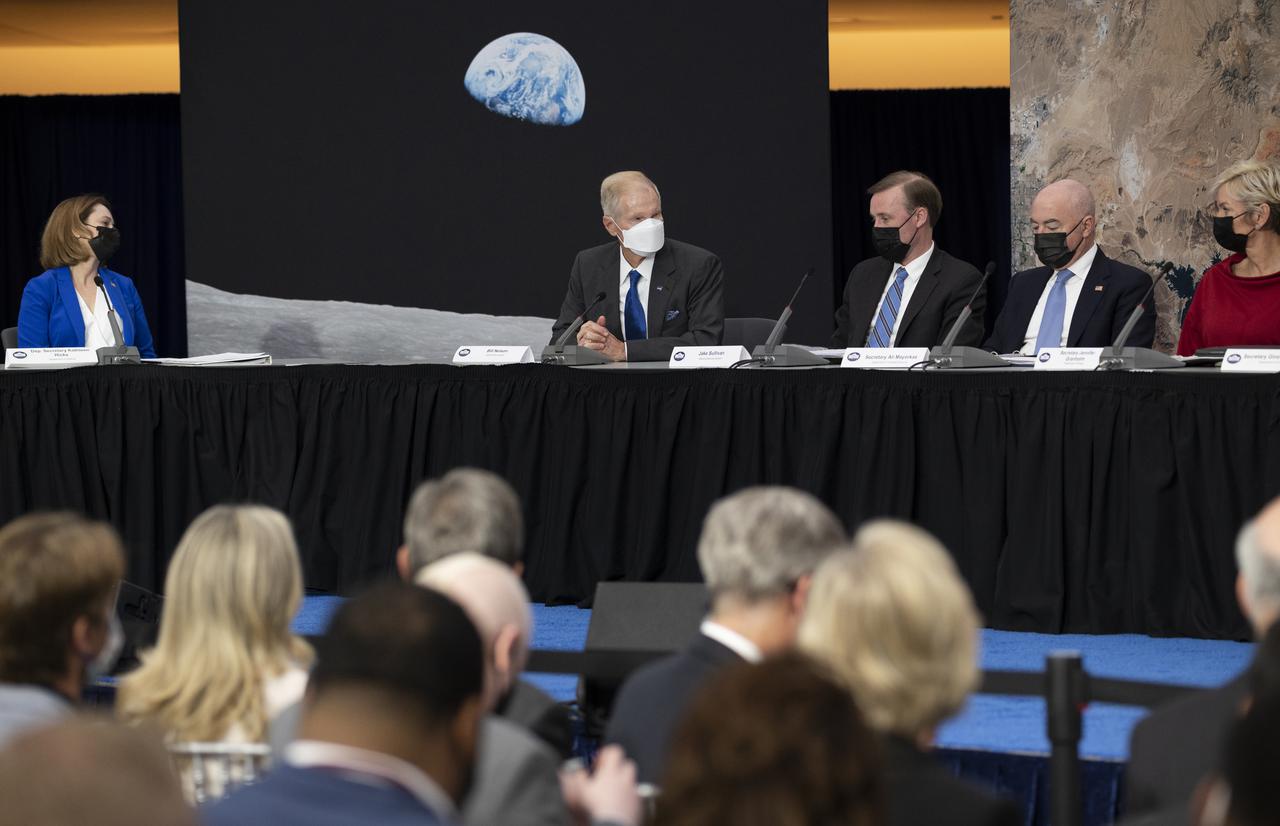
NASA Administrator Bill Nelson speaks during the first meeting of the National Space Council, Wednesday, Dec. 1, 2021, at the United States Institute of Peace in Washington. Chaired by Vice President Kamala Harris, the council's role is to advise the President regarding national space policy and strategy, and ensuring the United States capitalizes on the opportunities presented by the country’s space activities. Photo Credit: (NASA/Joel Kowsky)
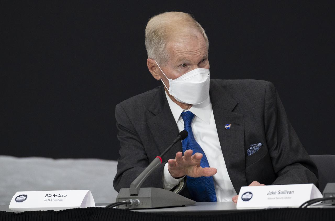
NASA Administrator Bill Nelson speaks during the first meeting of the National Space Council, Wednesday, Dec. 1, 2021, at the United States Institute of Peace in Washington. Chaired by Vice President Kamala Harris, the council's role is to advise the President regarding national space policy and strategy, and ensuring the United States capitalizes on the opportunities presented by the country’s space activities. Photo Credit: (NASA/Joel Kowsky)

Sen. Mark Kelly, D-Ariz., introduces Vice President Kamala Harris, at the first meeting of the National Space Council, Wednesday, Dec. 1, 2021, at the United States Institute of Peace in Washington. Chaired by Vice President Harris, the council's role is to advise the President regarding national space policy and strategy, and ensuring the United States capitalizes on the opportunities presented by the country’s space activities. Photo Credit: (NASA/Joel Kowsky)

Adm. Jim Ellis, USN (Ret.), Chairman of the National Space Council’s Users' Advisory Group, speaks at the first meeting of the National Space Council, Wednesday, Dec. 1, 2021, at the United States Institute of Peace in Washington. Chaired by Vice President Kamala Harris, the council's role is to advise the President regarding national space policy and strategy, and ensuring the United States capitalizes on the opportunities presented by the country’s space activities. Photo Credit: (NASA/Joel Kowsky)
Vice President Kamala Harris delivers opening remarks at the first meeting of the National Space Council, Wednesday, Dec. 1, 2021, at the United States Institute of Peace in Washington. Chaired by Vice President Harris, the council's role is to advise the President regarding national space policy and strategy, and ensuring the United States capitalizes on the opportunities presented by the country’s space activities. Photo Credit: (NASA/Joel Kowsky)

Vice President Kamala Harris delivers opening remarks at the first meeting of the National Space Council, Wednesday, Dec. 1, 2021, at the United States Institute of Peace in Washington. Chaired by Vice President Harris, the council's role is to advise the President regarding national space policy and strategy, and ensuring the United States capitalizes on the opportunities presented by the country’s space activities. Photo Credit: (NASA/Joel Kowsky)
NASA Administrator Bill Nelson speaks during the first meeting of the National Space Council, Wednesday, Dec. 1, 2021, at the United States Institute of Peace in Washington. Chaired by Vice President Kamala Harris, the council's role is to advise the President regarding national space policy and strategy, and ensuring the United States capitalizes on the opportunities presented by the country’s space activities. Photo Credit: (NASA/Joel Kowsky)
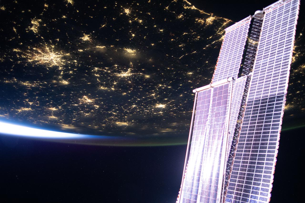
iss073e0273067 (June 20, 2025) --- City lights sparkle across the southern United States in this photograph taken at approximately 4:44 a.m. local time from the International Space Station is it orbited into a sunrise 260 miles above Florida. In the right foreground, is a set of the orbital outpost's main solar arrays augmented by a smaller set of roll out solar arrays.
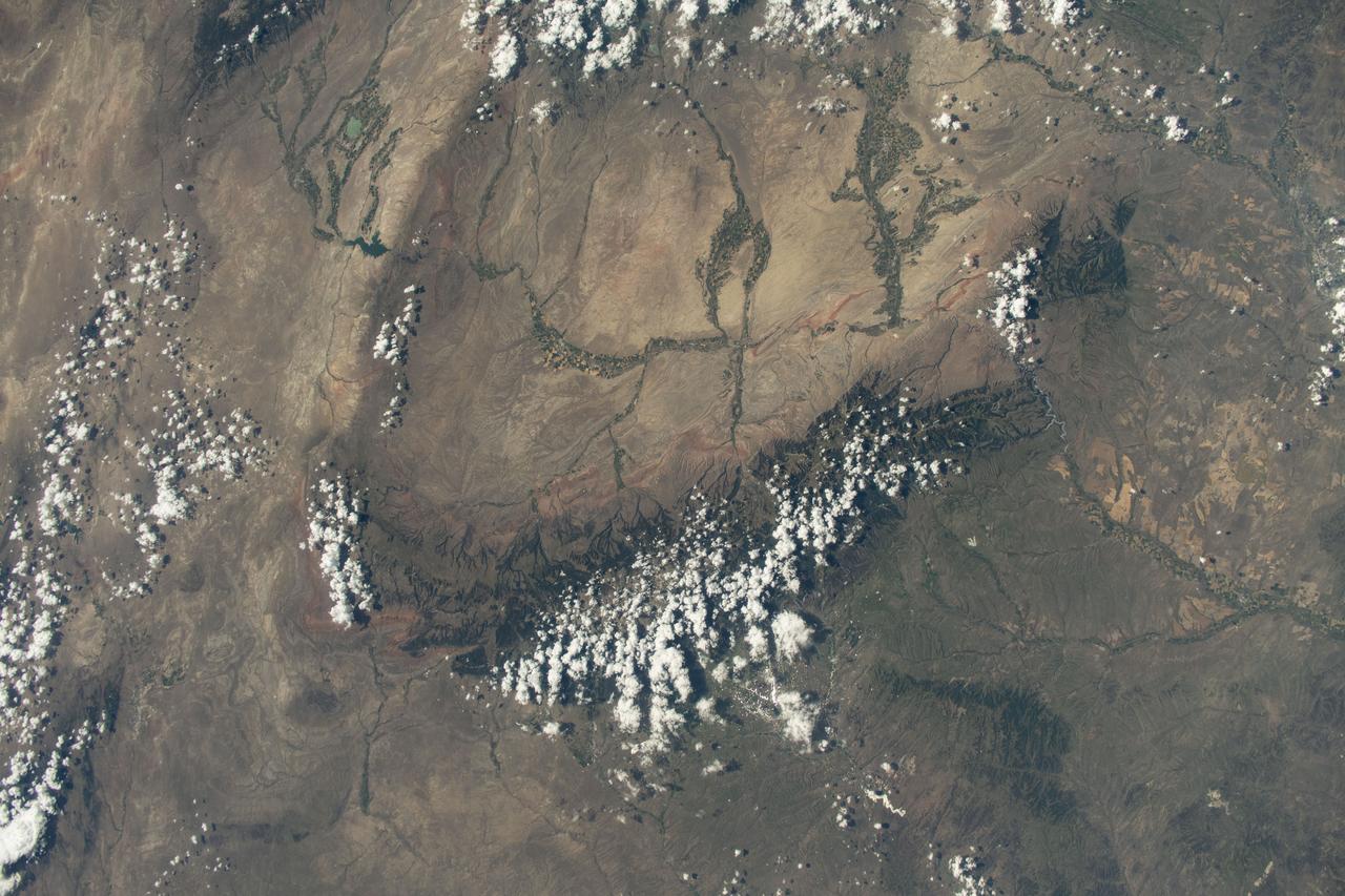
iss073e0420598 (Aug. 3, 2025) --- Bighorn National Forest in Wyoming and Custer National Forest in Montana, located in the Rocky Mountains region of the United States, are pictured from the International Space Station as it orbited 261 miles above.
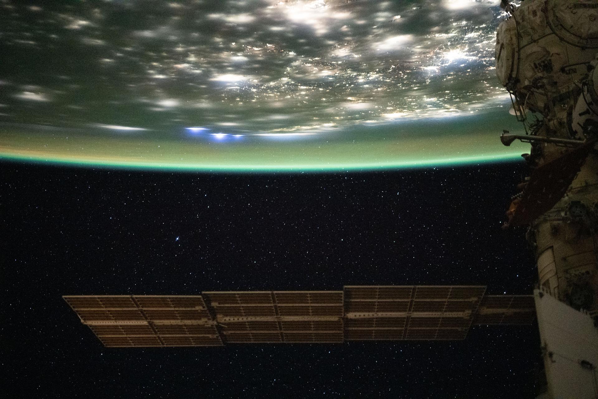
iss072e842757 (March 15, 2025) --- City lights dot the cloudy, midwestern landscape of the United States with a wispy aurora above Earth's horizon in this photograph from the International Space Station as it orbited 261 miles above the Sunflower State of Kansas. In the bottom foreground, is the Kibo laboratory module's Exposed Facility, an external research platform, and the orbital outpost's main solar arrays.

iss069e010181 (May 12, 2023) --- The Soyuz MS-23 crew ship is pictured docked to the Prichal docking module as the International Space Station orbited 261 miles above the northeast coast of the United States. The city lights of New York City and the surrounding metropolitan area are easily visible from the orbital outpost.
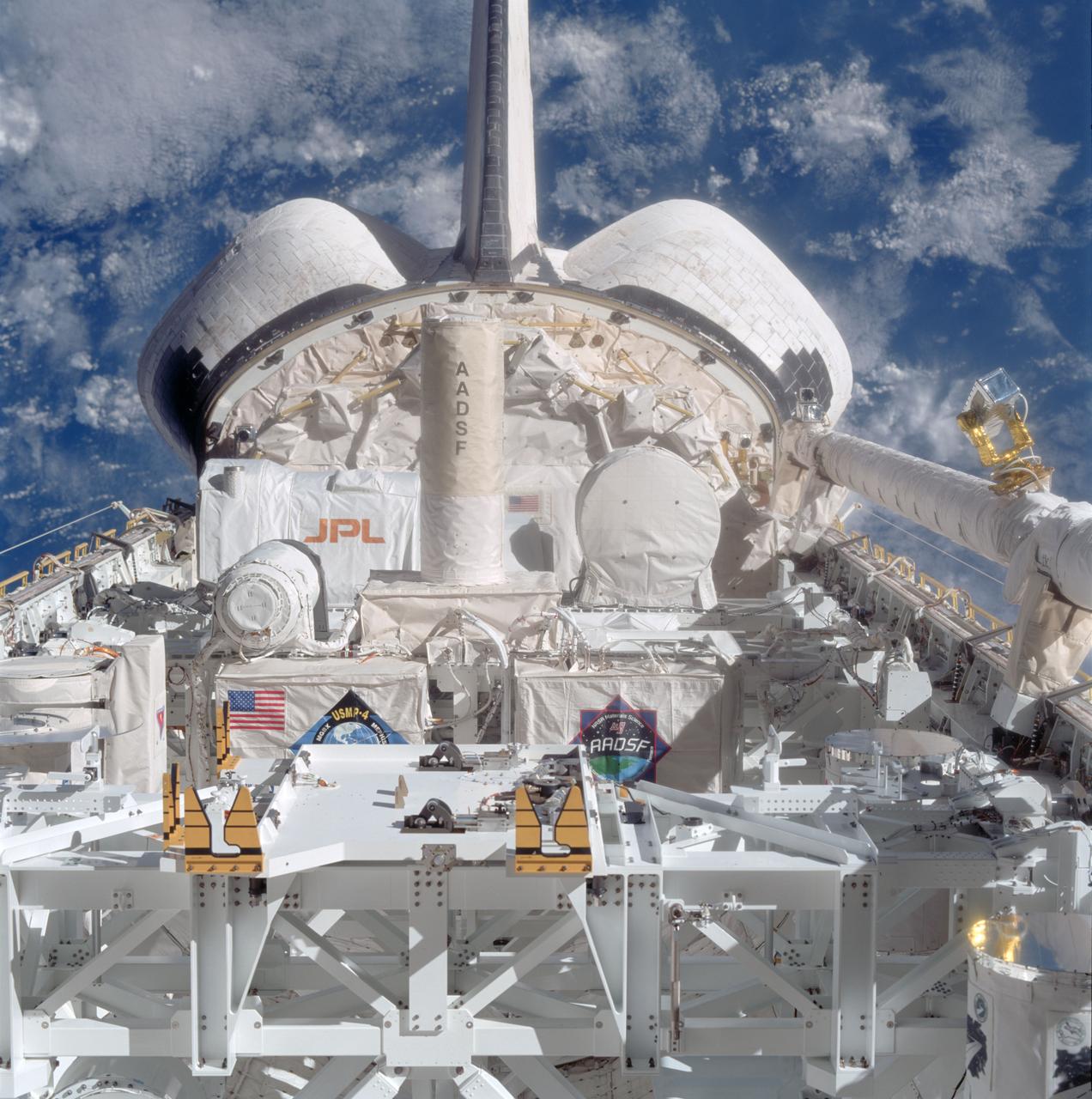
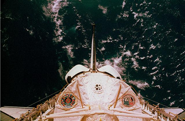
STS087-706-022 (19 November - 5 December 1997) --- This picture of the Space Shuttle Columbia's cargo bay, taken through the aft flight deck windows with a handheld 70mm camera, shows the United States Microgravity Payload 4 (USMP-4) mission's payloads.
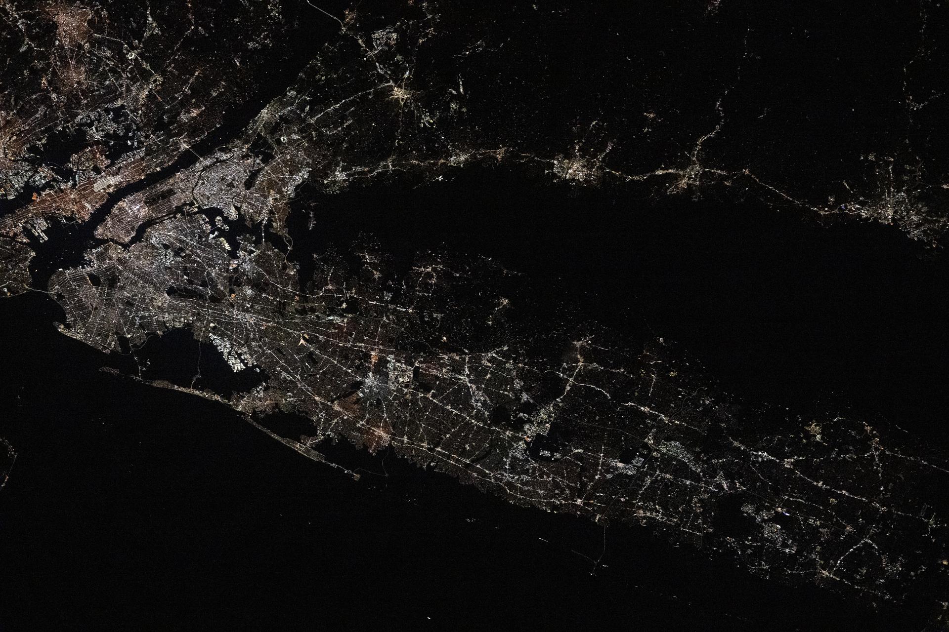
iss073e0982169 (Oct. 25, 2025) --- Long Island, New York—the most populous island in the United States—stretches 118 miles from west to east, extending from Brooklyn to Montauk Point. It lies between Long Island Sound to the north and the New York/New Jersey Bight to the south. Toward the upper left, New York City's island borough of Manhattan is visible, with the Hudson River and East River flowing on either side. The city's bright lights contrast with the elongated, darkened area of Central Park. This image was captured at approximately 2:24 a.m. local time from the International Space Station as it orbited 263 miles above the Empire State.
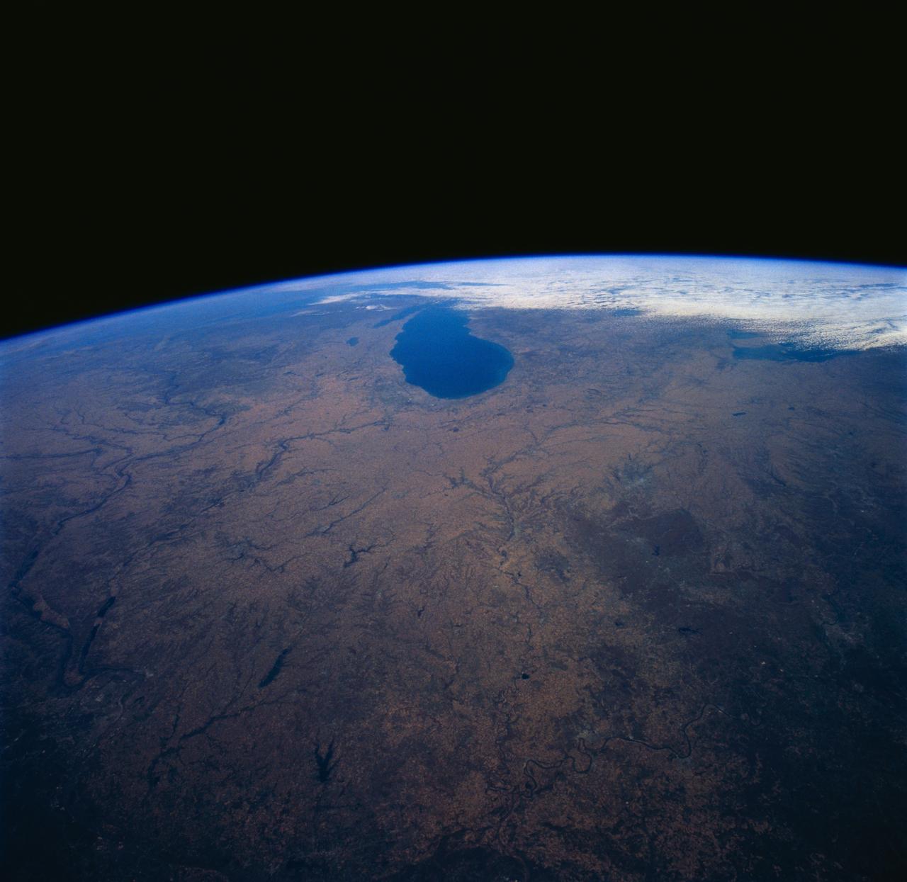
SL4-139-4040 (10 Jan. 1974) --- An oblique view of a portion of the Western United States, as photographed from the Skylab space station in Earth orbit by one of the Skylab 4 crewmen. The camera used was a hand-held 70mm Hasselblad, with SO-368 medium-speed Ektachrome film. This photograph is one of a stereo pair (the other being 4039) taken to support the hydrological studies of the changing snow patterns in several watersheds. Stereo analysis will enable snow to be distinguished from clouds quantitatively. In a qualitative sense, the clouds are the fuzzy white, whereas the snow is distinct white. The area covered is from the Colorado Springs, Colorado area at the south to (and beyond) the Black Hills, South Dakota area. The Black Forest between Colorado Springs and Denver is evident as are the mountains west of these cities. South Park, west of Colorado Springs, and the South Platte River running north and east from Denver are two other conspicuous features. Photo credit: NASA
iss073e0982450 (Oct. 25, 2025) --- A blue-green airglow blankets the bright city lights of the eastern United States, with bluish-white lightning strikes visible on Earth's horizon near the center-left of the frame. Stars twinkle in the night sky in the lower half of the image, captured at approximately 2:03 a.m. local time from the International Space Station as it orbited 262 miles above northeastern Pennsylvania.
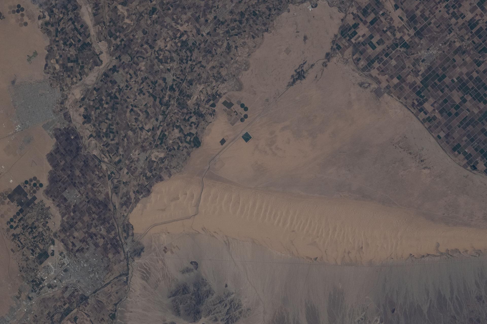
iss073e0886792 (Oct. 1, 2025) --- The Mexico–United States border separates Baja California (left) on the Mexican side from California (right) on the U.S. side in this photograph from the International Space Station as it orbited 261 miles above. This region is part of the Sonoran Desert, with the Algodones Dunes prominently visible on the U.S. side. Near upper left, is the Mexican city of San Luis Río Colorado with a population of about 177,000.
iss073e0287480 (June 4, 2025) --- Wichita, Kansas, is pictured in the center of a wide open gap surrounded by clouds covering the midwestern United States in this photograph from the International Space Station as it orbited 261 miles above. At bottom right, a portion of the SpaceX Dragon crew spacecraft is seen docked to the orbital outpost's forward port on the Harmony module.

The United States Joint Armed Forces Color Guard presents the colors during a Congressional Gold Medal ceremony recognizing NASA’s Hidden Figures, Wednesday, Sept. 18, 2024, in Emancipation Hall at the U.S. Capitol in Washington. Congressional Gold Medals were awarded to Katherine Johnson, Dr. Christine Darden, Dorothy Vaughan, and Mary W. Jackson in recognition of their service to the United States as well as a Congressional Gold Medal in recognition of all the women who served as computers, mathematicians, and engineers at the National Advisory Committee for Aeronautics and NASA between the 1930s and 1970s. Photo Credit: (NASA/Joel Kowsky)
A very anomalous weather pattern is in place over the U.S. for mid-July. Trapped between an upper level ridge centered over the Ohio Valley and the closed upper level low over the Texas/Oklahoma border, atypical hot, muggy air is stifling a broad swath of the eastern U.S. The closed low is expected to drift west toward New Mexico bringing heavy, localized rain to some areas and temperatures running 10-20 degrees below mid-July averages. Across the east, temperatures will warm well into the 90's and stay there through the week. This image was taken by GOES East at 1645Z on July 15, 2013. Image credit: <b><a href="http://goes.gsfc.nasa.gov/" rel="nofollow">Credit: NOAA/NASA GOES Project</a></b> Text credit: NOAA <b><a href="http://www.nasa.gov/audience/formedia/features/MP_Photo_Guidelines.html" rel="nofollow">NASA image use policy.</a></b> <b><a href="http://www.nasa.gov/centers/goddard/home/index.html" rel="nofollow">NASA Goddard Space Flight Center</a></b> enables NASA’s mission through four scientific endeavors: Earth Science, Heliophysics, Solar System Exploration, and Astrophysics. Goddard plays a leading role in NASA’s accomplishments by contributing compelling scientific knowledge to advance the Agency’s mission. <b>Follow us on <a href="http://twitter.com/NASA_GoddardPix" rel="nofollow">Twitter</a></b> <b>Like us on <a href="http://www.facebook.com/pages/Greenbelt-MD/NASA-Goddard/395013845897?ref=tsd" rel="nofollow">Facebook</a></b> <b>Find us on <a href="http://instagram.com/nasagoddard?vm=grid" rel="nofollow">Instagram</a></b>
This is a photograph of the Spacelab module for the first United States Microgravity Laboratory (USML-1) mission, showing logos of the Spacelab mission on the left and the USML-1 mission on the right. The USML-1 was one part of a science and technology program that opened NASA's next great era of discovery and established the United States' leadership in space. From investigations designed to gather fundamental knowledge in a variety of areas to demonstrations of new equipment, USML-1 forged the way for future USML missions and helped prepare for advanced microgravity research and processing aboard the Space Station. Thirty-one investigations comprised the payload of the first USML-1 mission. The experiments aboard USML-1 covered five basic areas: fluid dynamics, the study of how liquids and gases respond to the application or absence of differing forces; crystal growth, the production of inorganic and organic crystals; combustion science, the study of the processes and phenomena of burning; biological science, the study of plant and animal life; and technology demonstrations. The USML-1 was managed by the Marshall Space Flight Center and launched aboard the Space Shuttle Orbiter Columbia (STS-50) on June 25, 1992.
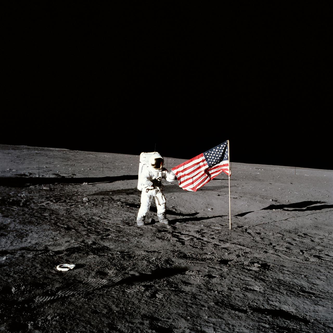
AS12-47-6897 (19 Nov. 1969) --- Astronaut Charles Conrad Jr., Apollo 12 commander, stands beside the United States flag after it was unfurled on the lunar surface during the first extravehicular activity (EVA), on Nov. 19, 1969. Several footprints made by the crewmembers can be seen in the photograph. While astronauts Conrad and Alan L. Bean, lunar module pilot, descended in the Lunar Module (LM) "Intrepid" to explore the Ocean of Storms region of the moon, astronaut Richard F. Gordon Jr., command module pilot, remained with the Command and Service Modules (CSM) "Yankee Clipper" in lunar orbit.
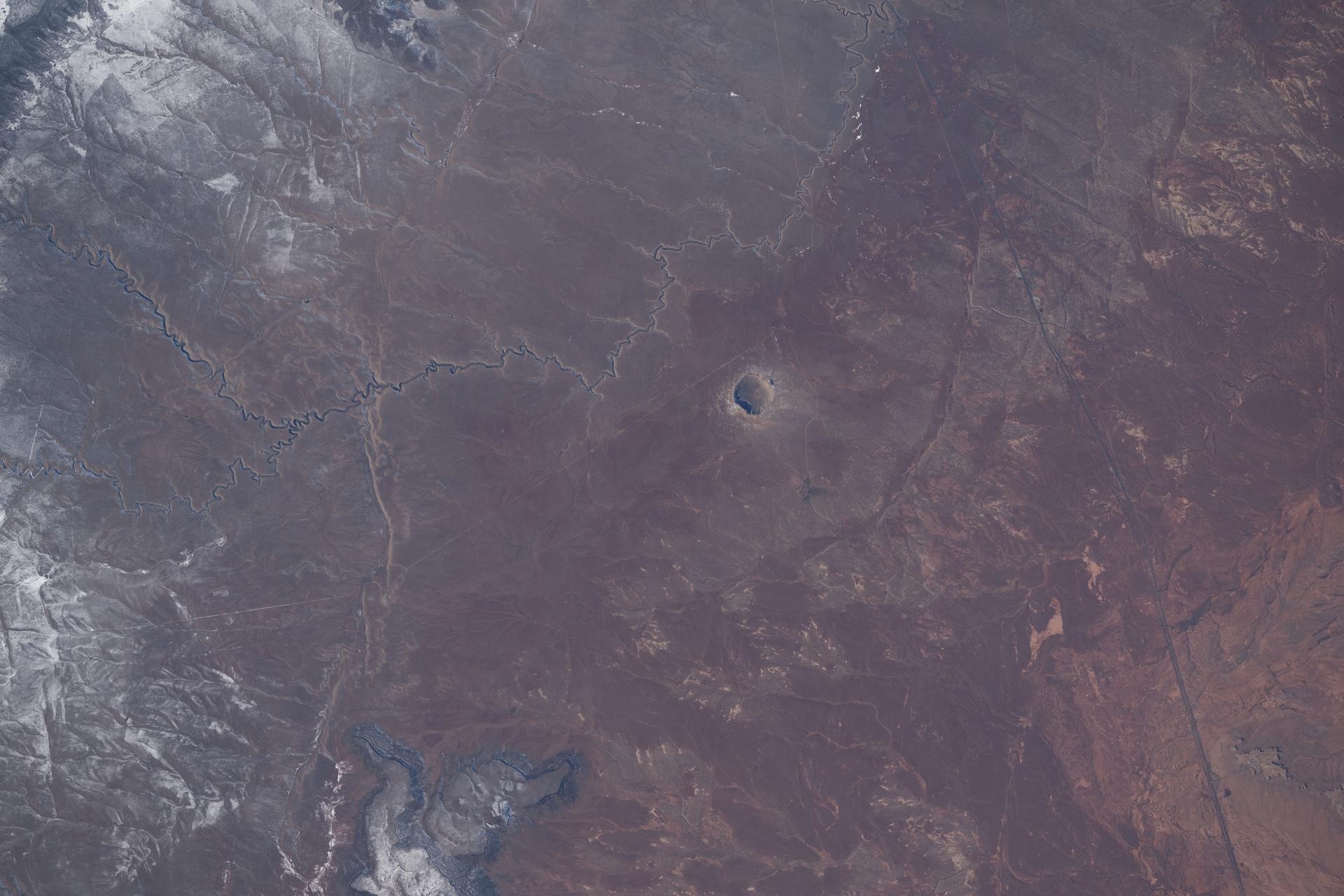
iss074e0208832 (Jan. 26, 2026) --- Meteor Crater in Arizona, a meteorite impact site approximately 4,000 feet in diameter and formed about 50,000 years ago in the high desert of the Colorado Plateau, is pictured from the International Space Station as it orbited 260 miles above the southwestern United States.
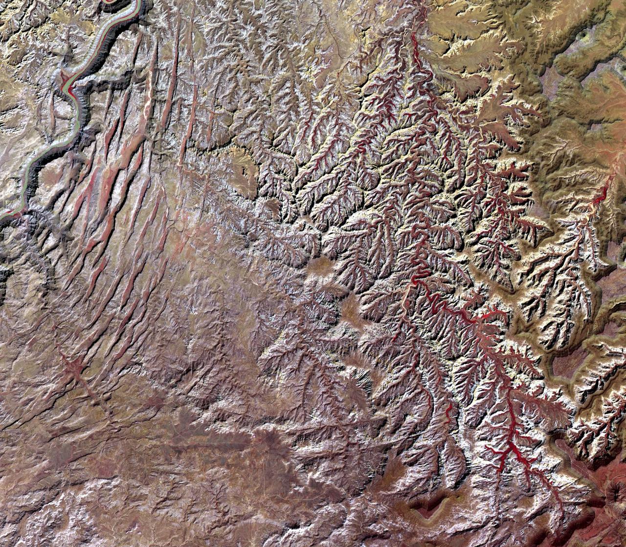
This image, acquired by NASA Terra spacecraft, is of Canyonlands National Park, Utah, a showcase of geology in the southwest desert of the United States.
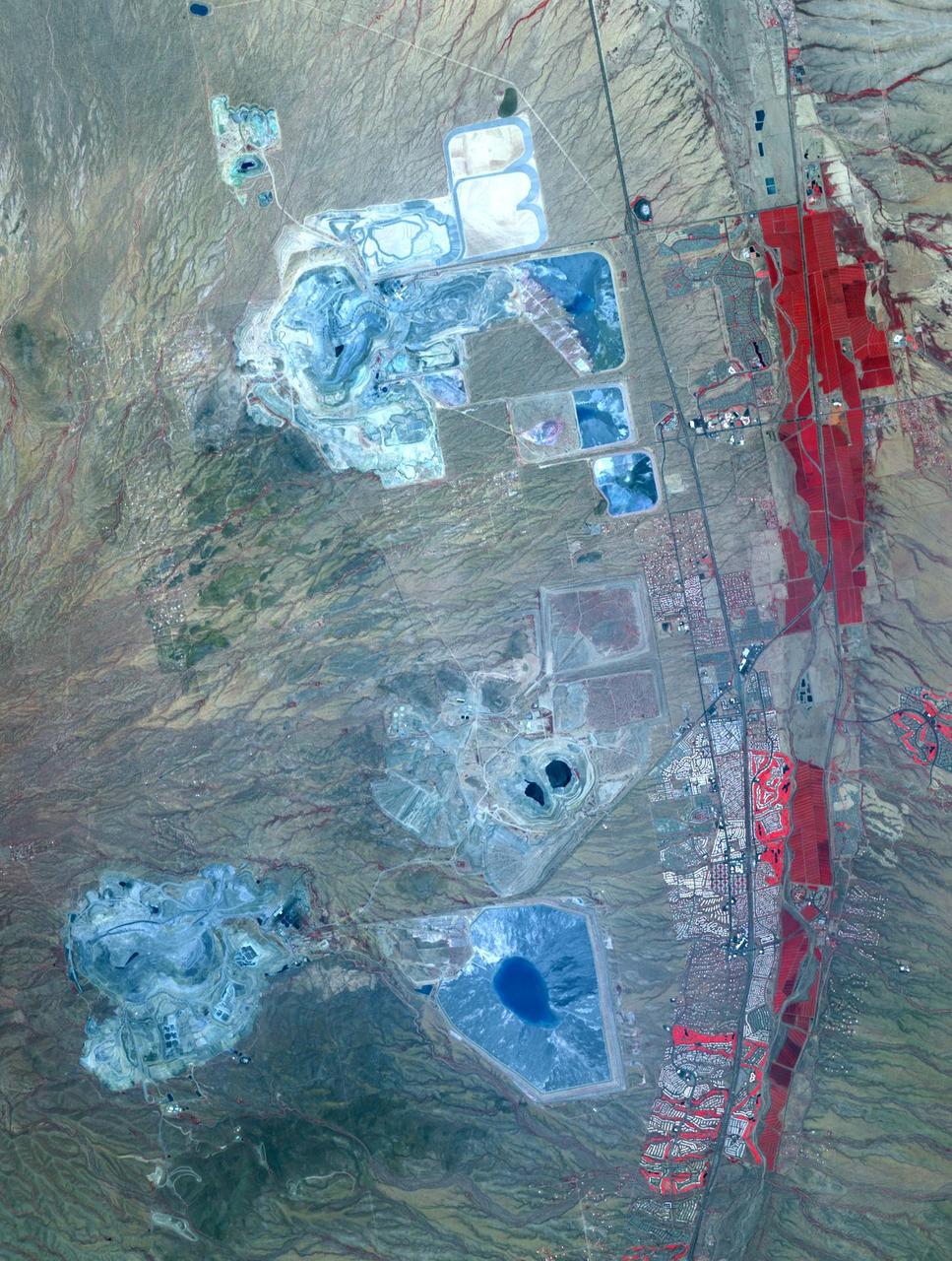
This image acquired by NASA Terra spacecraft shows Arizona, Calif., which produces 60% of the total copper mined in the United States.
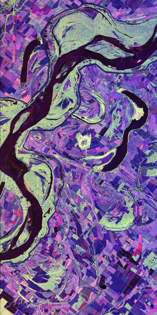
This image of the Mississippi River in Mississippi, Arkansas, and Louisiana shows regions of the southern United States that are prone to flooding.
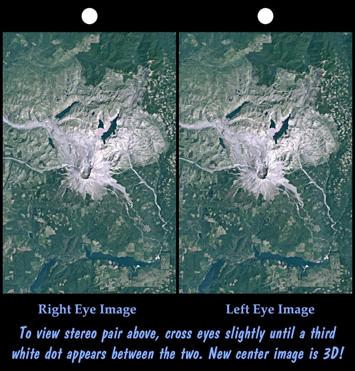
On May 18, 1980, Mount St. Helens catastrophically erupted, causing the worst volcanic disaster in the recorded history of the United States.
This is a Space Shuttle Columbia (STS-52) onboard photograph of the United States Microgravity Payload-1 (USMP-1) in the cargo bay. The USMP program is a series of missions developed by NASA to provide scientists with the opportunity to conduct research in the unique microgravity environment of the Space Shuttle's payload bay. The USMP-1 mission was designed for microgravity experiments that do not require the hands-on environment of the Spacelab. Science teams on the ground would remotely command and monitor instruments and analyze data from work stations at NASA's Spacelab Mission Operation Control facility at the Marshall Space Flight Center (MSFC). The USMP-1 payload carried three investigations: two studied basic fluid and metallurgical processes in microgravity, and the third would characterize the microgravity environment onboard the Space Shuttle. The three experiments that made up USMP-1 were the Lambda Point Experiment, the Space Acceleration Measurement System, and the Materials for the Study of Interesting Phenomena of Solidification Earth and in Orbit (MEPHISTO). The three experiments were mounted on two cornected Mission Peculiar Equipment Support Structures (MPESS) mounted in the orbiter's cargo bay. The USMP program was managed by the MSFC and the MPESS was developed by the MSFC.
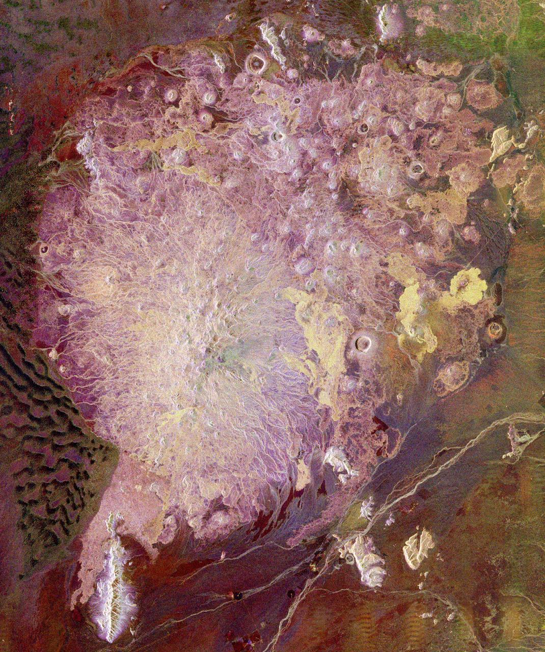
This spaceborne radar image shows the Pinacate Volcanic Field in the state of Sonora, Mexico, about 150 kilometers 93 miles southeast of Yuma, Arizona. The United States/Mexico border runs across the upper right corner of the image.

Sault Ste. Marie is the name of two cities on Saint Mary River, separating Canada and the State of Michigan in the United States. This image was acquired by NASA Terra spacecraft on June 10, 2007.

The first United States Microgravity Laboratory (USML-1) flew in orbit inside the Spacelab science module for extended periods, providing scientists and researchers greater opportunities for research in materials science, fluid dynamics, biotechnology (crystal growth), and combustion science. This photograph shows Astronaut Larry De Lucas wearing a stocking plethysmograph during the mission. Muscle size in the legs changes with exposure to microgravity. A stocking plethysmograph, a device for measuring the volume of a limb, was used to help determine these changes. Several times over the course of the mission, an astronaut will put on the plethysmograph, pull the tapes tight and mark them. By comparing the marks, changes in muscle volume can be measured. The USML-1 was launched aboard the Space Shuttle Orbiter Columbia (STS-50) on June 25, 1992.