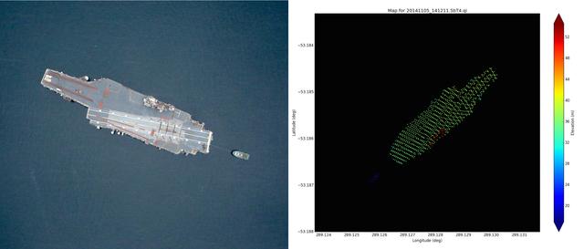
Left: NASA Digital Mapping System image of the USS Constellation taken near Punta Arenas, Chile on Nov. 5, 2014. Credit: NASA/DMS Right: Airborne Topographic Mapper wide scan lidar elevation data taken over the USS Constellation during Nov. 5, 2014 overflight. The water elevation has been removed and was 17 meters. The Constellation flight deck is about 16m above the water surface and the conning tower is about 33m above the water. Credit: NASA/ATM Read more: <a href="http://www.nasa.gov/content/goddard/icebridge/news/fall14/uss-constellation-and-thurston-island-nov-5/#.VGOy4khvL2g" rel="nofollow">www.nasa.gov/content/goddard/icebridge/news/fall14/uss-co...</a>

NASA’s Operation IceBridge collected some rare images on a flight out of Punta Arenas, Chile on Nov. 5, 2014, on a science flight over western Antarctica dubbed Ferrigno-Alison-Abbott 01. Following a routine calibration pass over Punta Arenas airport, the NASA DC-8 overflew the USS Constellation which is being towed for demolition after 53 yeas of service. The crew then snapped a few shots of a calving front of the Antarctic ice sheet. This particular flight plan was designed to collect data on changes in ice elevation along the coast near the Ferrigno and Alison ice streams, on the Abbot Ice Shelf, and grounded ice along the Eights Coast.