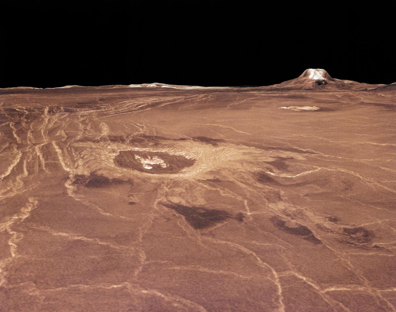
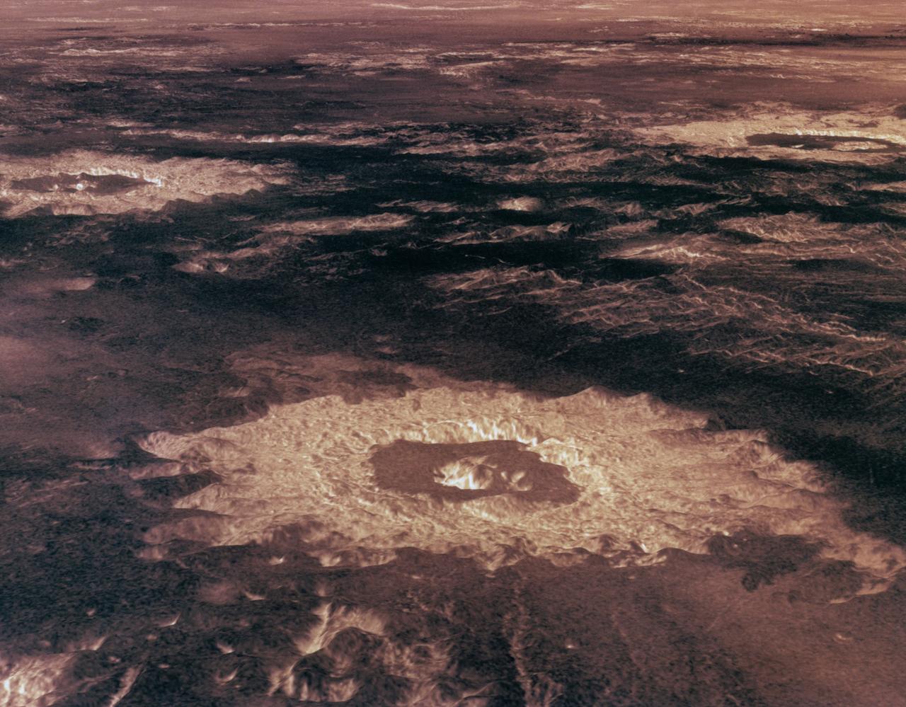
Magellan synthetic aperture radar data was used to create this three- dimensional (3D) perspective view of Venus' western Eistla Regio. This viewpoint is located at 1,310 kilometers (812 miles) southwest of Gula Mons at an elevation of 0.178 kilometers (0.48 miles). The view is of the northeast with Gula Mons appearing on the horizon. Gula Mons, a 3 kilometer (1.86 mile) high volcano, is located at approximately 22 degrees north latitude, 359 degrees east longitude. The impact crater Cunitz, named for the astronomer and mathematician Maria Cunitz, is visible in the center of the image. The crater is 48.5 kilometers (30 miles) in diameter and is 215 kilometers (133 miles) from the viewer's position. Magellan synthetic aperture radar data is combined with radar altimetry to develop a 3D map of the surface. Rays cast in a computer intersect the surface to create a 3D view. Simulated color and a digital elevation map developed by the United States (U.S.) Geological Survey is used to enhance small-scale structure. The simulated hues are based on color images recorded by the Soviet Venera 13 and 14 spacecraft. The image was produced at the Jet Propulsion Laboratory (JPL) Multimission Image Processing Laboratory and is a single frame from a video released at the JPL news conference 03-05-91. View was provided by JPL with alternate number P-38720 MGN76.

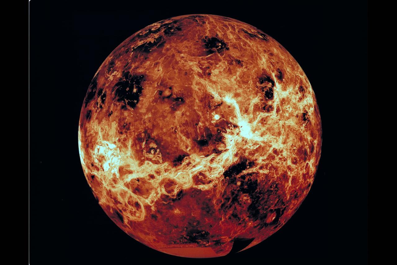
This global view of Venus, centered at 270 degrees east longitude, is a compilation of data from several sources. Magellan synthetic aperature radar mosaics from the first cycle of Magellan mapping are mapped onto a computer-simulated globe to create the image. Data gaps are filled with Pioneer-Venus orbiter data, or a constant mid-range value. Simulated color is used to enhance small-scale structure. The simulated hues are based on color images recorded by the Soviet Venera 13 and 14 spacecraft. The image was produced at the Jet Propulsion Laboratory (JPL) Multimission Image Processing Laboratory and is a single frame from a video released at the JPL news conference, 10-29-91. View provided by JPL with alternate number P-39225 MGN81.
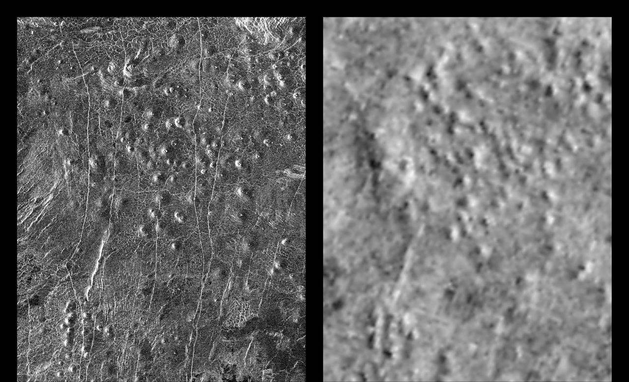
These radar images show an identical area on Venus (centered at 110 degrees longitude and 64 degrees north latitude) as imaged by the U.S. NASA Magellan spacecraft in 1991 (left) and the U.S.S.R. Venera 15/16 spacecraft in the early 1980's (right). Illumination is from the left (or west) in the Magellan image (left) and from the right (or east) in the Venera image (right). Differences in apparent shading in the images are due to differences in the two radar imaging systems. Prior to Magellan, the Venera 15/16 data was the best available for scientists studying Venus. Much greater detail is visible in the Magellan image owing to the greater resolution of the Magellan radar system. In the area seen here, approximately 200 small volcanoes, ranging in diameter from 2 to 12 kilometers (1.2 to 7.4 miles) can be identified. These volcanoes were first identified as small hills in Venera 15/16 images and were predicted to be shield-type volcanoes constructed mainly from eruptions of fluid lava flows similar to those that produce the Hawaiian Islands and sea floor volcanoes - a prediction that was confirmed by Magellan. These small shield-type volcanoes are the most abundant geologic feature on the surface of Venus, believed to number in the hundreds of thousands, perhaps millions, and are important evidence in understanding the geologic evolution of the planet. The only other planet in our Solar System with this large number of volcanoes is Earth. Clearly visible in the Magellan image are details of volcano morphology, such as variation in slope, the occurrence and size range of summit craters, and geologic age relationships between adjacent volcanoes, as well as additional volcanoes that were not identifiable in the Venera image. http://photojournal.jpl.nasa.gov/catalog/PIA00465
This global view of the surface of Venus is centered at 270 degrees east longitude. Magellan synthetic aperture radar mosaics from the first cycle of Magellan mapping are mapped onto a computer-simulated globe to create this image. Data gaps are filled with Pioneer-Venus orbiter data, or a constant mid-range value. Simulated color is used to inhance small-scale structure. The simulated hues are based on color images recorded by the Soviet Venera 13 and 14 spacecraft.
The northern hemisphere is displayed in this global view of the surface of Venus. The north pole is at the center of the image; with 0 degrees, 90 degrees , 180 degrees, 270 degrees east longitudes at 6, 3, 12 and 9 0'clock positions, repectively, of an imagery clock face. Magellan synthetic aperture radar mosaics from the first cycle of Magelolan mapping are mapped onto a computer-simulated globe to create this image. Data gaps are filled with Pioneere-Venus Orbiter data, or a constant mid-range value. Simulated color is used to enhance small-scale structure. The simulated hues are based on color images recorded by the Soviet Venera 13 & 14 spacecraft.
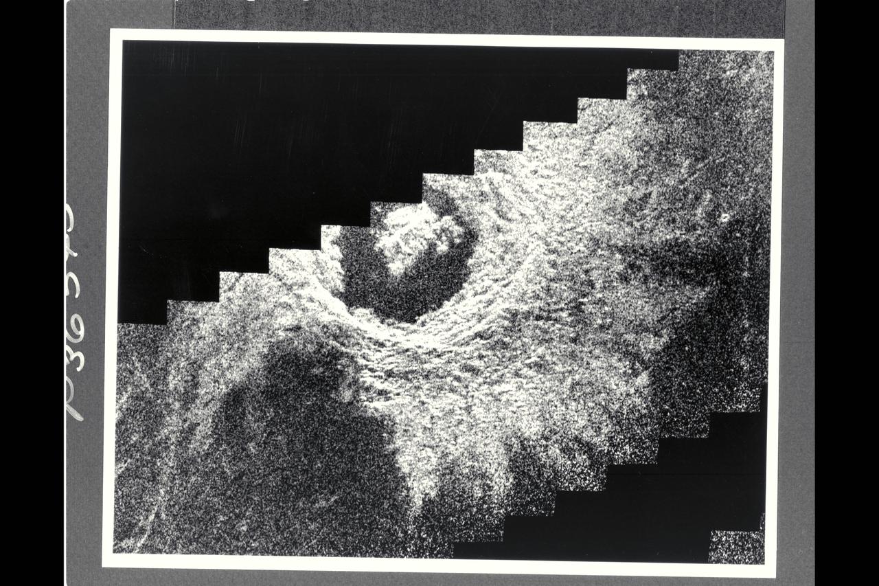
This Magellan image mosaic shows the impact crater Golubkina, first identified in Soviet Venera 15/16 data. The crater is names after Anna Golubkina (1864-1927), a Soviet sculptor. The crater is about 34 km (20.4 mi.) across, similar to the size of the West Clearwater impact structure in Canada. The crater Golubkina is located at about 60.5 degrees north latitude, 286.7 degrees est longitude. Magellan data reveal that Golubkina has many characteristics typical of craters formed by a mereorite impact including terraced inner walls, a central peak, and radar-bright rough ejecta surrounding the crater. The extreme darkness of the crater floor indicates a smooth surface, perhaps formed by the ponding of lava flows in the crater floor as seen in may lunar impact craters. The radar-bright ejecta surrounding the crater indicates a relatively fresh or young crater. Craters with centeral peaks in the Soviet data range in size from about 10-60 km (6-36 mi.) across. The largest crater identifed in the Soviet Venera data is 140 km (84 mi) in diameter. This Magellan image strip in approx. 100 km (62 mi.) long. The image is a mosaic of two orbits obtained in the first Magellan radar test and played back to Earth to the Deep Space Network stations near Goldstone, CA and Canberra, Australia, respectively. The resolution of this image is approximately 120 meters (400 feet). The see-saw margins result from the offset of individual radar frames obtained along the orbit. The spacecraft moved from the north (top) to the south, looking to the left.
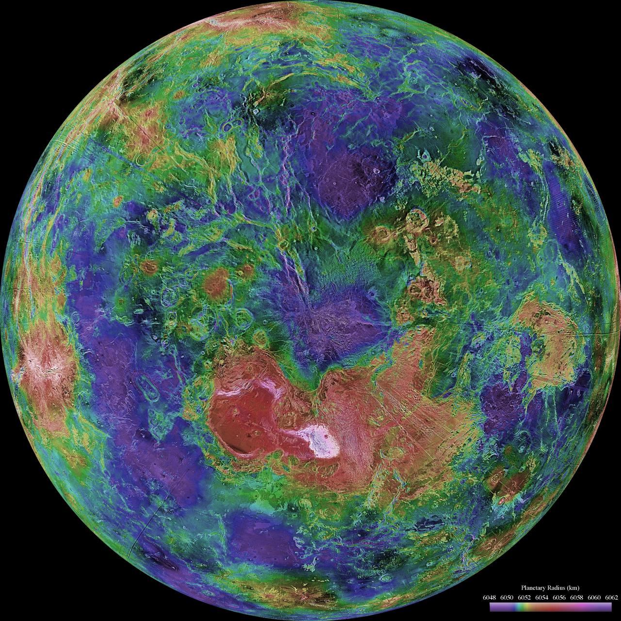
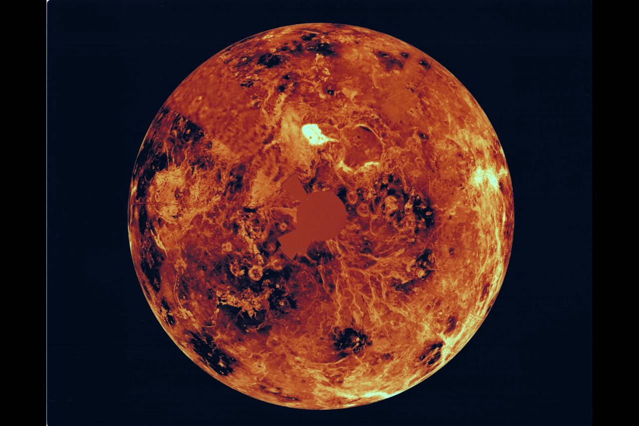
The hemispheric view of Venus, as revealed by more than a decade of radar investigations culminating in the 1990-1994 Magellan mission, is centered on the North Pole. The Magellan spacecraft imaged more than 98% of Venus at a resolution of about 100 meters; the effective resolution of this image is about 3 km. A mosaic of the Magellan images (most with illumination from the west) forms the image base. Gaps in the Magellan coverage were filled with images from the Earth-based Arecibo radar in a region centered roughly on 0 degree latitude and longitude, and with a neutral tone elsewhere (primarily near the south pole). The composite image was processed to improve contrast and to emphasize small features, and was color-coded to represent elevation. Gaps in the elevation data from the Magellan radar altimeter were filled with altimetry from the Venera spacecraft and the U.S. Pioneer Venus missions. An orthographic projection was used, simulating a distant view of one hemisphere of the planet. The Magellan mission was managed for NASA by Jet Propulsion Laboratory (JPL), Pasadena, CA. Data processed by JPL, the Massachusetts Institute of Technology, Cambridge, MA, and the U.S. Geological Survey, Flagstaff, AZ. http://photojournal.jpl.nasa.gov/catalog/PIA00007
Three impact craters in three-dimensional perspective located approximately 27 degrees south latitude, 339 degrees east longitude in the northwestern portion of Lavinia Planitia. The viewpoint is located southwest of Howe Crater which appears centered in the lower portion of the image. Howe has a diameter of 37.3 kilometers (23.1 miles) located at 28.6 degrees south latitude, 337.1 degrees east longitude. Danilova, a crater with a diameter of 47.6 kilometers (29.5 miles) and located at 26.35 degrees south latitude and 337.5 east longitude, appears above and to the left of Howe in the image. Aglaonice, a crater with a diameter of 62.7 kilometers (38.9 miles) and located at 26.5 degrees south latitude and 340 degrees east longitude is on the right of Danilova. Magellan synthetic aperture radar data is combined with radar altimetry to develop a 3D map of the surface. Rays cast in a computer intersect the surface to create a 3D view. Simulated color and a digital elevation map developed by the United States (U.S.) Geological Survey is used to enhance small-scale structure. The simulated hues are based on color images recorded by the Soviet Venera 13 and 14 spacecraft. The image was processed at the Jet Propulsion Laboratory (JPL) Multimission Image Processing Laboratory and is a single frame from a video released at the JPL news conference 05-29-91. View provided by JPL with alternate number P-39146.