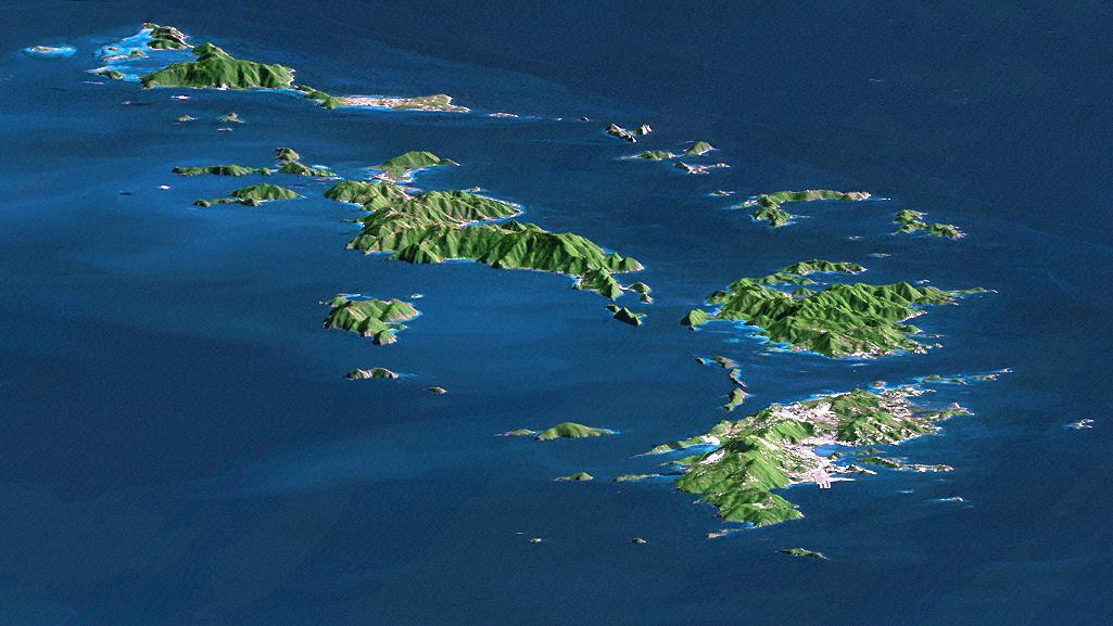
St. Thomas, St. John, Tortola, and Virgin Gorda are the four main islands front to back of this east-looking view of the U.S. Virgin Islands and British Virgin Islands, along the northeast perimeter of the Caribbean Sea.
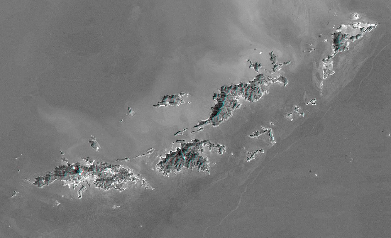
St. Thomas, St. John, Tortola, and Virgin Gorda are the four main islands lower left to upper right of this map-view anaglyph of the U.S. Virgin Islands and British Virgin Islands from NASA Shuttle Radar Topography Mission. 3D glasses are necessary.
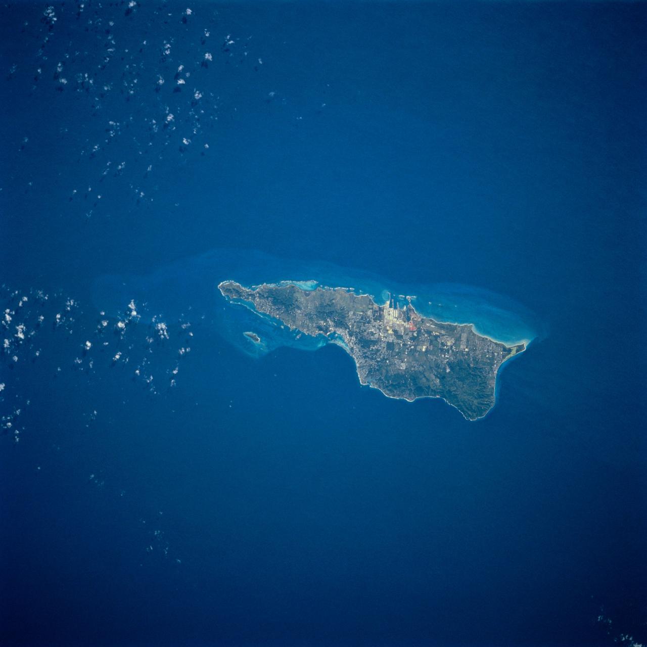
STS054-74-049 (13-19 Jan. 1993) --- St. Croix is the largest, and most industrial of the U.S. Virgin Islands. This photograph captures St. Croix's features in great detail. The large industrial complex in the middle of the southern shore is the world's largest petroleum refinery. The main city, Christiansted, can be seen across the island on the north shore. The reefs around the eastern end of St. Croix are preserved as a submarine national park -- Buck Island Reef National Park -- around the small island off the north shore of the eastern end of St. Croix.
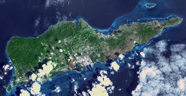
Saint Croix is a district of the U.S. Virgin Islands, in the Caribbean Sea. First inhabited by indigenous groups, the island was visited by Columbus in 1493. By the end of the 16th century, the island was uninhabited, the native population dispersed or killed. Starting in the 17th century, the island was successively claimed by the Spanish, the French, the French West India Company, and, for the next 200 years, the Danish West India Company. In 1801 the British invaded and took control; followed by Denmark-Norway a year later. Then again the British, and again Denmark in 1815. One hundred years later, in 1915, Denmark sold the Virgin Islands to the United States, and the inhabitants were granted US citizenship. Saint Croix was home to HOVENSA, one of the world's largest oil refineries. In 2012, the refinery closed, and tourism is now the main source of revenue (Wikipedia). The image covers an area of 18.7 by 36.2 km, was acquired March 10, 2011, and is located at 17.7 degrees north, 64.7 degrees west. https://photojournal.jpl.nasa.gov/catalog/PIA22894
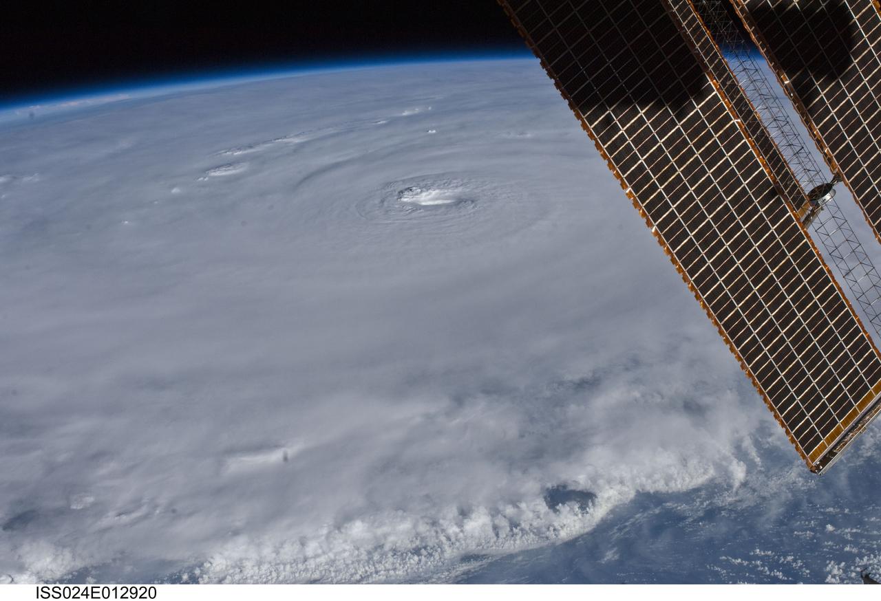
ISS024-E-012920 (30 Aug. 2010) --- Photographed by an Expedition 24 crew member on the International Space Station, this is an oblique view of the eye (just above center frame) of Hurricane Earl (at this time a category 4 but later downgraded to a category 3), centered just north of the Virgin Islands near 19.3 north latitude and 64.7 west longitude packing 115-kilometer winds. The photo was taken with a digital still camera using a 35mm lens.
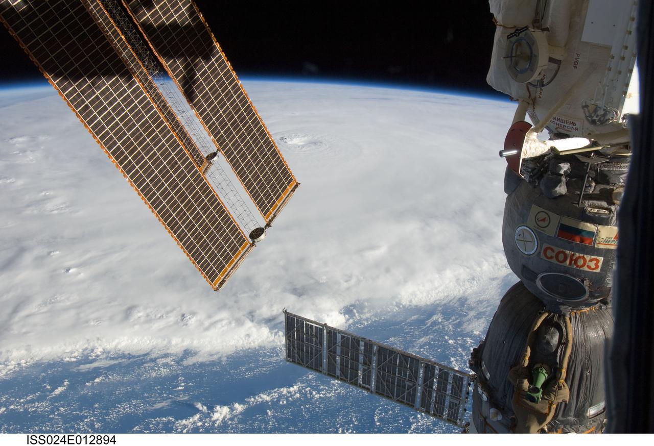
ISS024-E-012894 (30 Aug. 2010) --? Photographed by an Expedition 24 crew member on the International Space Station, this is an oblique view that shows the eye (just above center) of Hurricane Earl (at this time a category 4 but later downgraded to a category 3), centered just north of the Virgin Islands near 19.3 north latitude and 64.7 west longitude packing 115-kilometer winds. A Russian Soyuz vehicle is docked to the station (foreground). The photo was taken with a digital still camera using a 22mm lens.
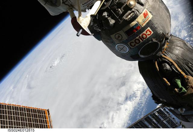
ISS024-E-012815 (30 Aug. 2010) --– Photographed by an Expedition 24 crew member on the International Space Station, this is an oblique view that shows the eye (just left of center) of Hurricane Earl (at this time a category 4 but later downgraded to a category 3), centered just north of the Virgin Islands near 19.3 north latitude and 64.7 west longitude packing 115-kilometer winds. A Russian Soyuz vehicle is docked to the station (foreground). The photo was taken with a digital still camera using a 55mm lens.
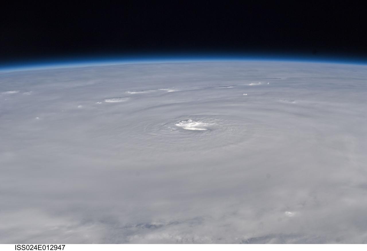
ISS024-E-012947 (30 Aug. 2010) --– Photographed by an Expedition 24 crew member on the International Space Station, this is an oblique view of the eye (center) of Hurricane Earl (at this time a category 4 but later downgraded to a category 3), centered just north of the Virgin Islands near 19.3 north latitude and 64.7 west longitude packing 115-kilometer winds. The photo was taken with a digital still camera using a 50mm lens.
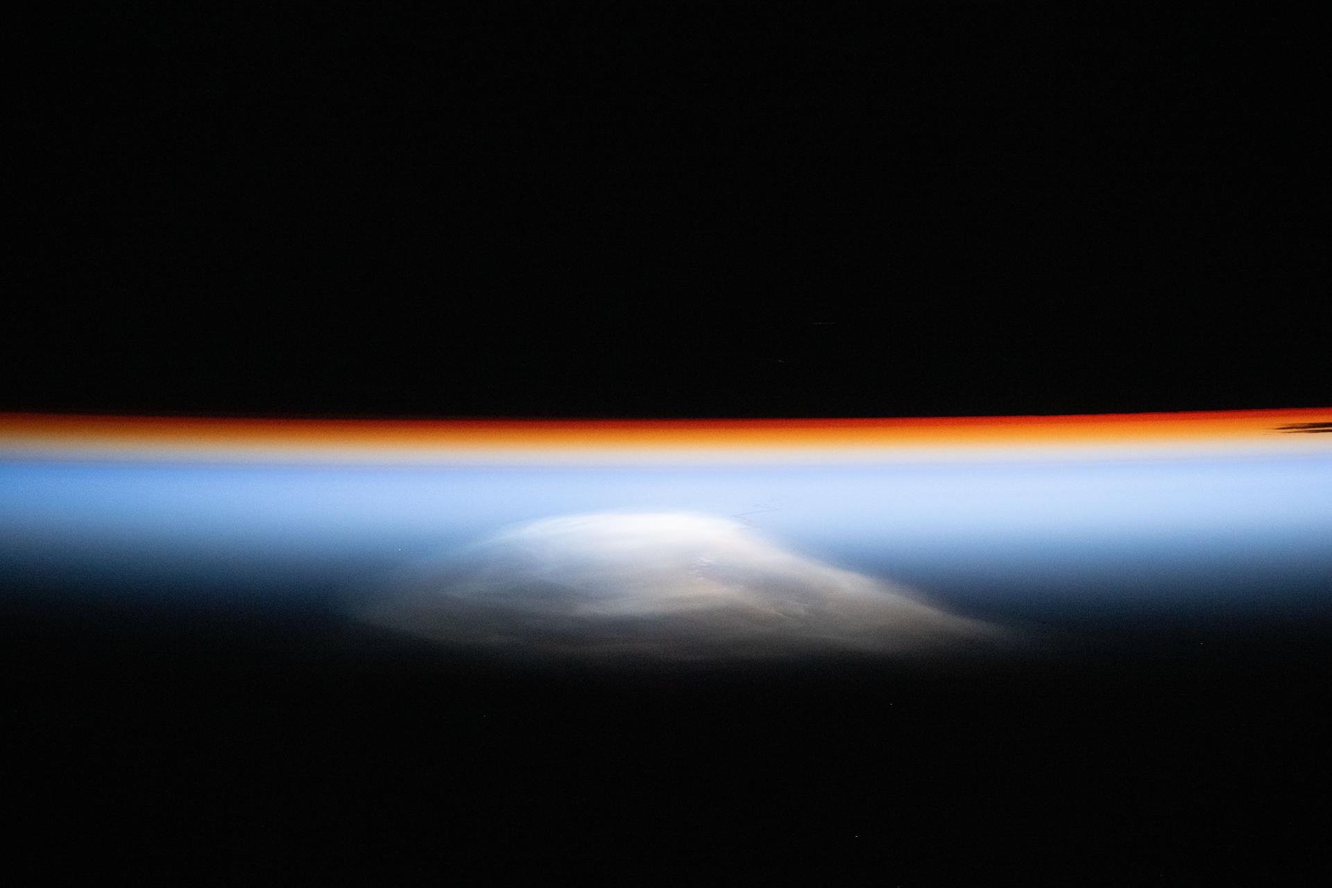
iss072e757530 (March 6, 2025) --- The last rays of an orbital sunset outline Earth’s horizon as a thin orange layer fades into blue, illuminating the atmosphere before nightfall. The wispy white feature above the atmosphere is the engine plume from the Ariane 6 rocket, launched earlier on its first operational mission from Kourou, French Guiana. This unique photograph was captured from the International Space Station at approximately 8:51 p.m. local time as it orbited 257 miles above the Atlantic Ocean, east of the British Virgin Islands.
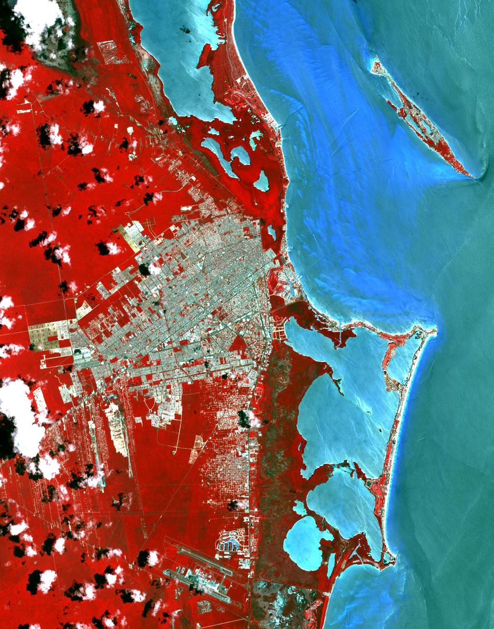
This image from NASA Terra spacecraft shows Cancun, a resort city on the east side of Mexico Yucatan Peninsula. In 1970, the population was 120 people. The city began as a tourism project in 1974. Since then, it has undergone a comprehensive transformation from being a fisherman's island surrounded by virgin forest and undiscovered shores to being one of the two most well-known Mexican resorts, along with Acapulco. In 1990 the city had grown to 167,000 inhabitants, and by 2014 to 723,000 inhabitants. These two images show the area on March 28, 1985, acquired by Landsat; and May 14, 2014, acquired by ASTER. The images cover an area of 25 x 36 km, and are located at 21.1 degrees north, 86.8 degrees west. http://photojournal.jpl.nasa.gov/catalog/PIA20086
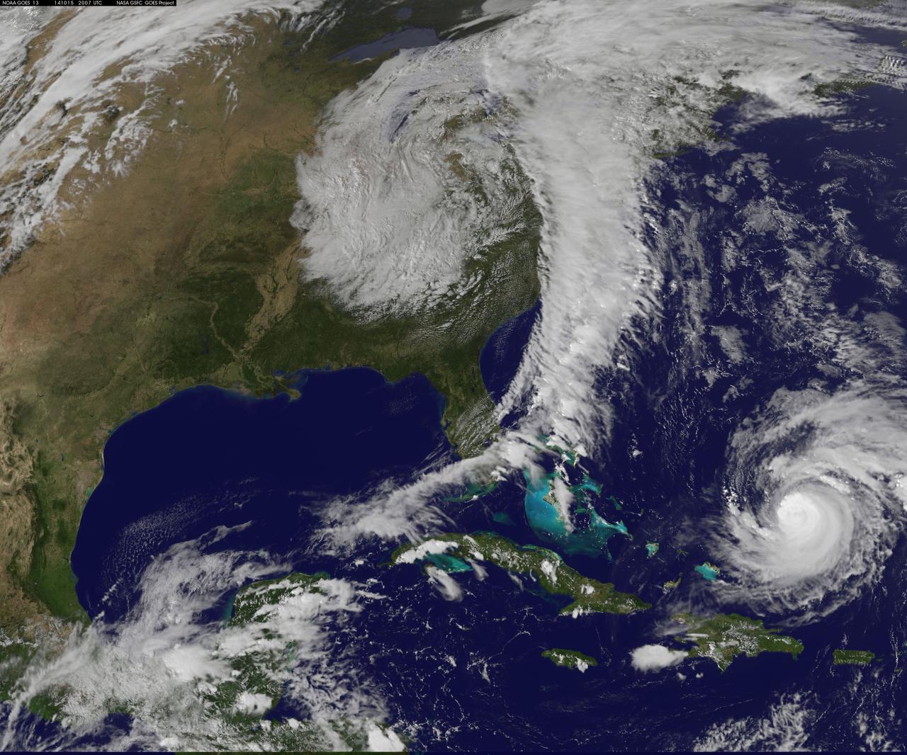
Hurricane Gonzalo has made the jump to major hurricane status and on Oct. 15 was a Category 4 storm on the Saffir-Simpson Hurricane Scale. NOAA's GOES-East satellite provided imagery of the storm. According to the National Hurricane Center, Gonzalo is the first category 4 hurricane in the Atlantic basin since Ophelia in 2011. NOAA's GOES-East satellite provides visible and infrared images of weather from its orbit in a fixed position over the Earth. On Oct. 15 at 15:15 UTC (11:15 a.m. EDT) GOES saw Gonzalo had tightly wrapped bands of thunderstorms spiraling into the center of its circulation. The eye of the storm was obscured by high clouds in the image. NOAA aircraft data and microwave images clearly show concentric eyewalls, with the inner radius of maximum winds now only about 4-5 nautical miles from the center. NOAA manages the GOES satellites, while NASA/NOAA's GOES Project at NASA's Goddard Space Flight Center in Greenbelt, Maryland created the image. The NASA/NOAA GOES Project creates images and animations from GOES data. At 11 a.m. EDT on Oct. 15, Gonzalo's maximum sustained winds increased to near 130 mph (215 kph) and the National Hurricane Center (NHC) noted that fluctuations in intensity are expected over the next couple of days. Gonzalo's cloud-covered eye was located near latitude 23.5 north and longitude 68.0 west, about 640 miles (1,025 km) south-southwest of Bermuda. Gonzalo is moving toward the northwest near 12 mph (19 kph). The minimum central pressure recently reported by an air force reconnaissance aircraft was 949 millibars. Tropical storm conditions are possible in Bermuda by late Thursday night, Oct. 16, and hurricane conditions are possible over Bermuda on Friday Oct. 16. Ocean swells however, will be felt over a much larger area, reached the U.S. east coast on Oct. 16. Large swells generated by Gonzalo are affecting portions of the Virgin Islands, the northern coasts of Puerto Rico and the Dominican Republic and portions of the Bahamas. Swells will reach much of the east coast of the United States and Bermuda on Thursday. By late Oct. 16, Gonzalo is expected to turn to the northeast and the center is expected to approach Bermuda sometime on Oct. 17. Credit: NASA/GSFC/Jeff Schmaltz/MODIS Land Rapid Response Team <b><a href="http://www.nasa.gov/audience/formedia/features/MP_Photo_Guidelines.html" rel="nofollow">NASA image use policy.</a></b> <b><a href="http://www.nasa.gov/centers/goddard/home/index.html" rel="nofollow">NASA Goddard Space Flight Center</a></b> enables NASA’s mission through four scientific endeavors: Earth Science, Heliophysics, Solar System Exploration, and Astrophysics. Goddard plays a leading role in NASA’s accomplishments by contributing compelling scientific knowledge to advance the Agency’s mission. <b>Follow us on <a href="http://twitter.com/NASAGoddardPix" rel="nofollow">Twitter</a></b> <b>Like us on <a href="http://www.facebook.com/pages/Greenbelt-MD/NASA-Goddard/395013845897?ref=tsd" rel="nofollow">Facebook</a></b> <b>Find us on <a href="http://instagram.com/nasagoddard?vm=grid" rel="nofollow">Instagram</a></b>