
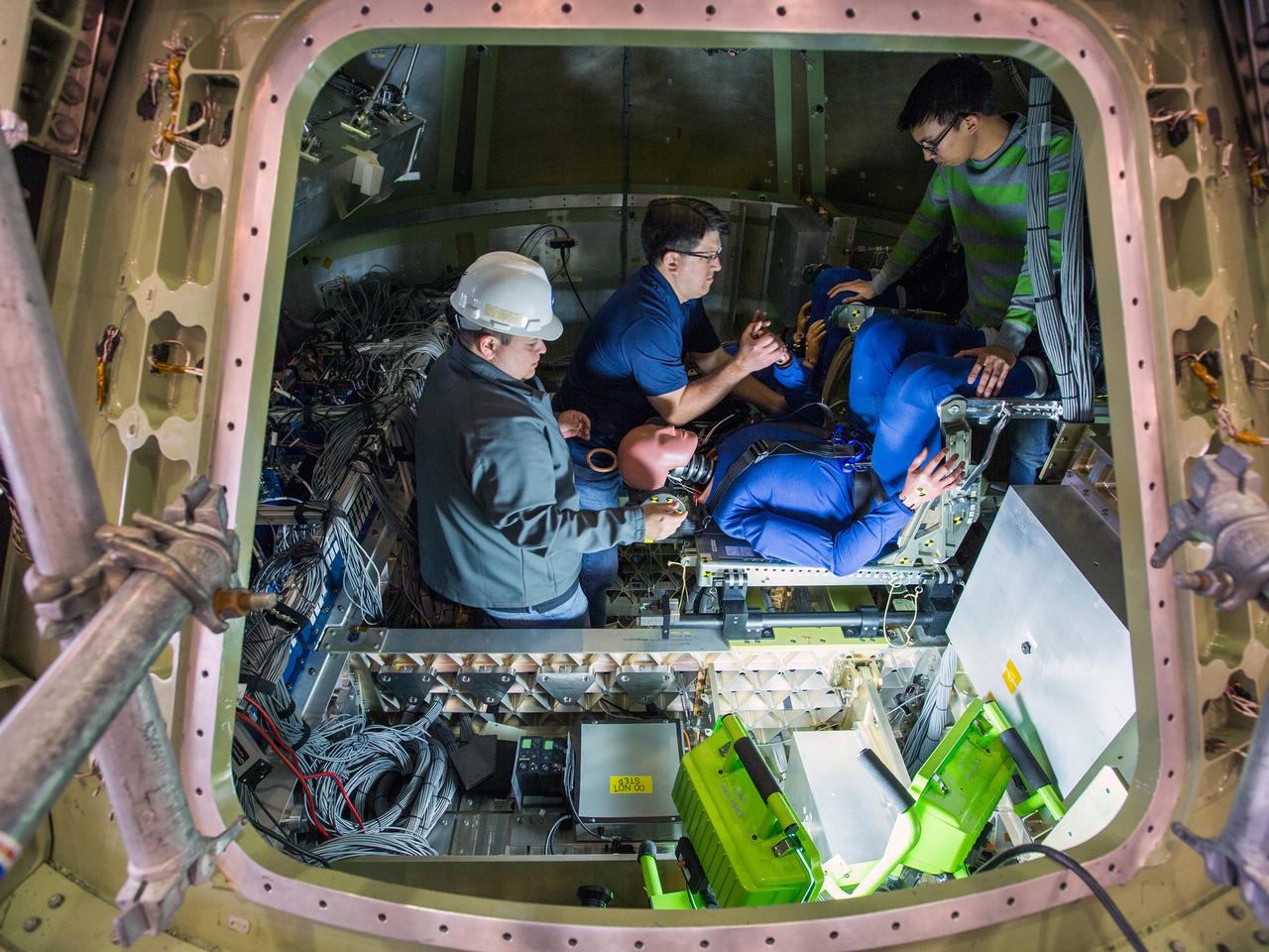
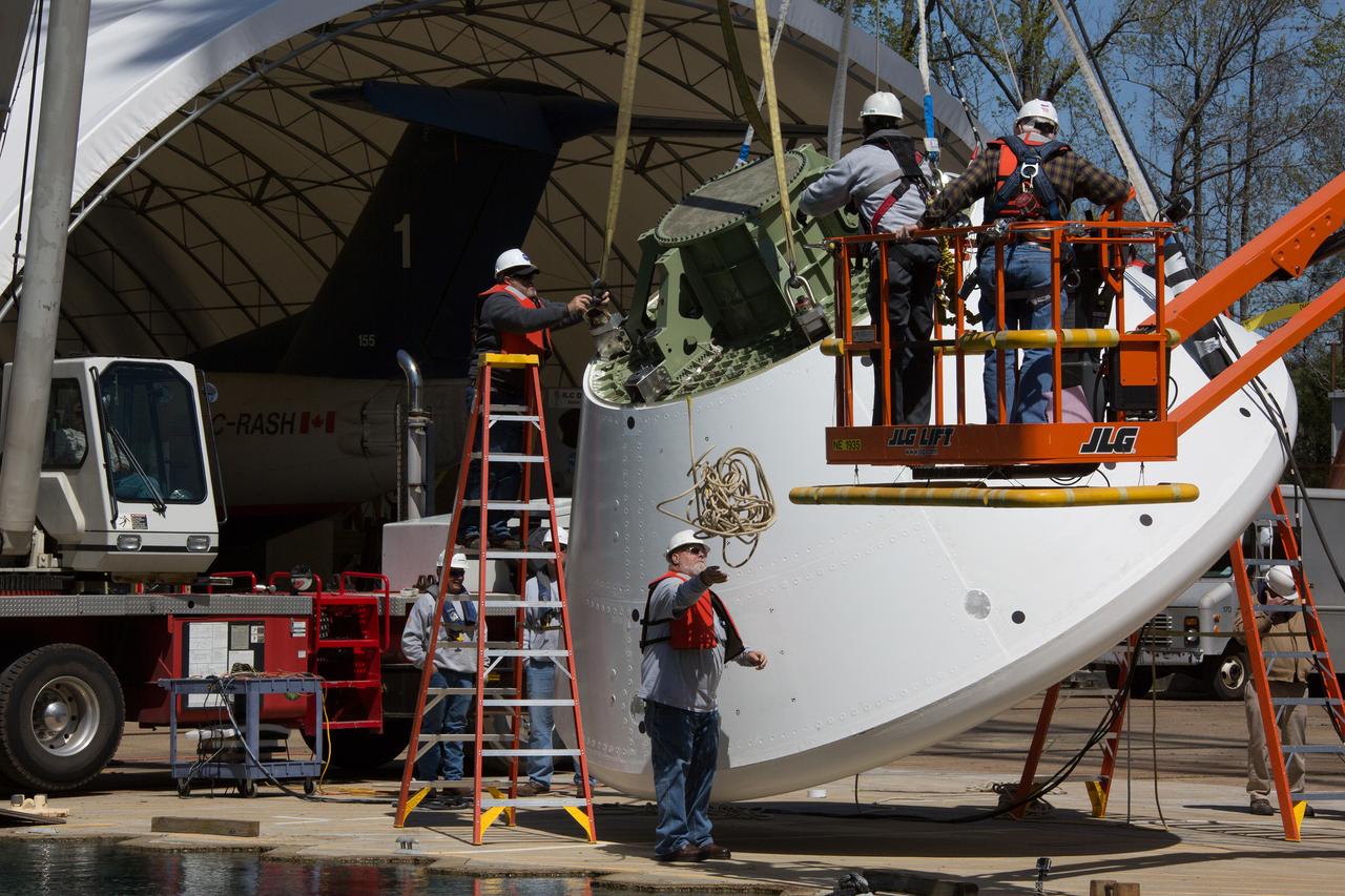
Engineers at NASA’s Langley Research Center in Hampton, Virginia, install test dummies into the seats of an Orion test article on Feb. 26, 2016. The capsule, coupled with the heat shield from the spacecraft’s first flight, will be used for water-impact testing to simulate what astronauts will experience when landing in the Pacific Ocean during a real mission.
Engineers at NASA’s Langley Research Center in Hampton, Virginia, install test dummies into the seats of an Orion test article on Feb. 26, 2016. The capsule, coupled with the heat shield from the spacecraft’s first flight, will be used for water-impact testing to simulate what astronauts will experience when landing in the Pacific Ocean during a real mission.

Engineers at NASA’s Langley Research Center in Hampton, Virginia, install test dummies into the seats of an Orion test article on Feb. 26, 2016. The capsule, coupled with the heat shield from the spacecraft’s first flight, will be used for water-impact testing to simulate what astronauts will experience when landing in the Pacific Ocean during a real mission.

Engineers at NASA’s Langley Research Center in Hampton, Virginia, install test dummies into the seats of an Orion test article on Feb. 26, 2016. The capsule, coupled with the heat shield from the spacecraft’s first flight, will be used for water-impact testing to simulate what astronauts will experience when landing in the Pacific Ocean during a real mission.
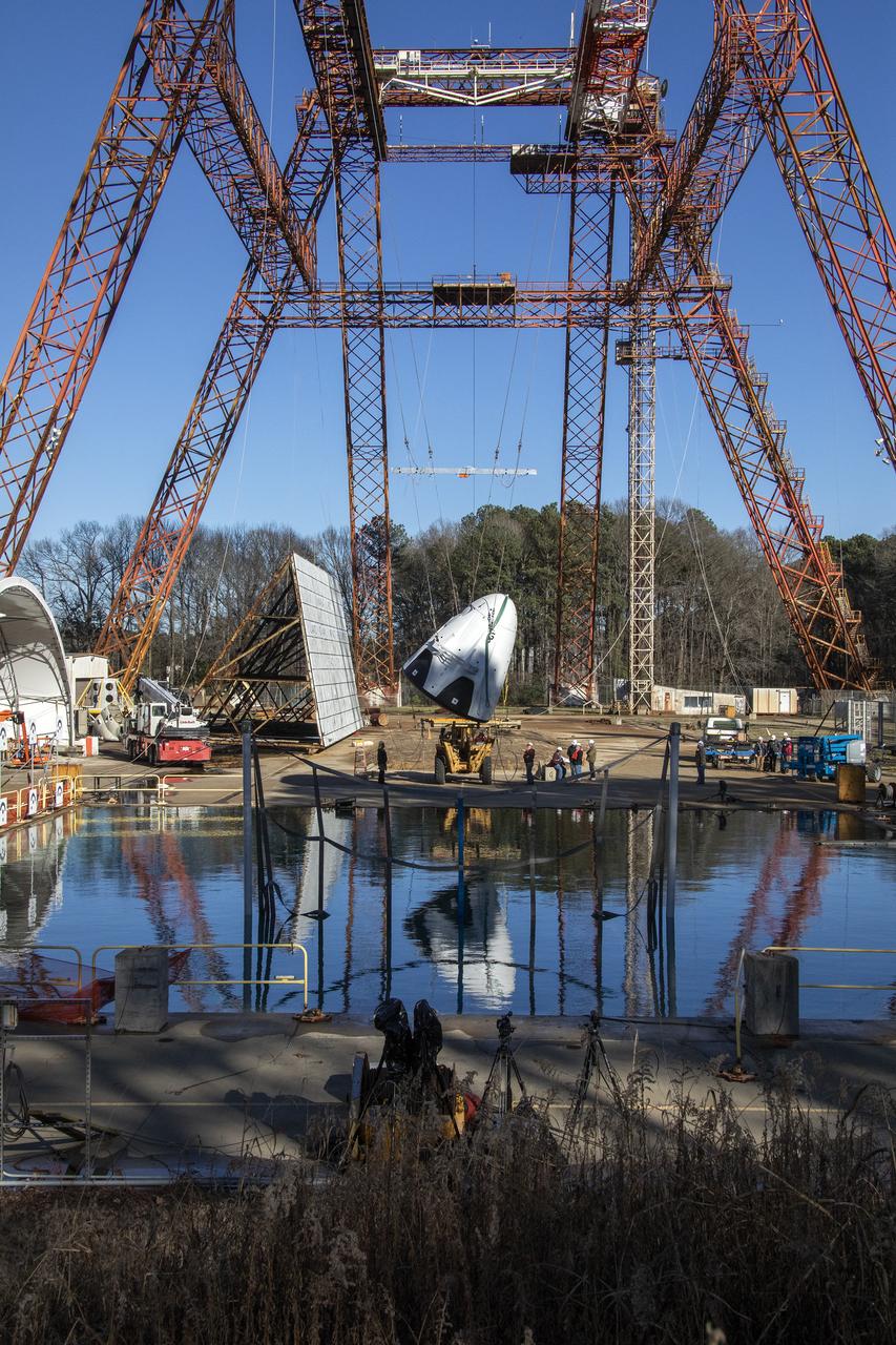
A 22,000-pound Orion test article is dropped into the Hydro Impact Basin at the Landing and Impact Research Facility at NASA’s Langley Research Center in Hampton, Virginia on July 12, 2011. The drop was the first in a series of water-impact tests conducted by NASA to provide high-fidelity data of the forces that the Orion spacecraft structure and its astronaut crew would experience during landing, helping to protect the crew and informing future designs. Part of Batch image transfer from Flickr.
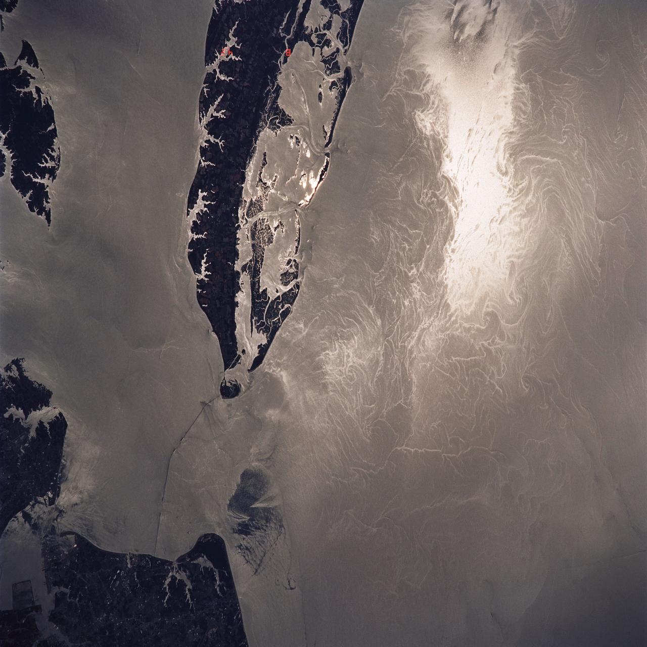
STS040-614-047 (5-14 June 1991) --- This image is of the Norfolk, Virginia -- Southern Delmarva Peninsula Southern Chesapeake Bay Area as seen in sunlight. The exposure is adjusted to emphasize the water patterns present. The outgoing tide generates considerable turbulence as it passes through the mouth of the bay. This is displayed by differences in reflective properties of the water surface due to differences in slope and turbidity. Ship wakes and the wakes of subsurface structures are seen clearly. The bridge tunnel system linking Norfolk with the peninsula and its effect on the system is quite apparent. Sunglint images over land areas were also acquired which emphasize land-water boundaries as demonstrated here in the small Delmarva inlets as a tool for wetland mapping, and river, lake and even pond description. During the first few days of the STS-40 mission the Eastern Seaboard of the United States was free of clouds and haze providing excellent photography of many of the major cities and the countryside of that area as well as the Gulf Stream.
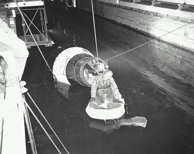
B60-00285 (1960) --- Astronaut John H. Glenn Jr., pilot of the Mercury Atlas 6 spaceflight, emerges from an egress trainer during training activity at the Langley Research Center. He is attempting to transfer onto a life raft from the mock-up of the Mercury capsule. Photo credit: NASA
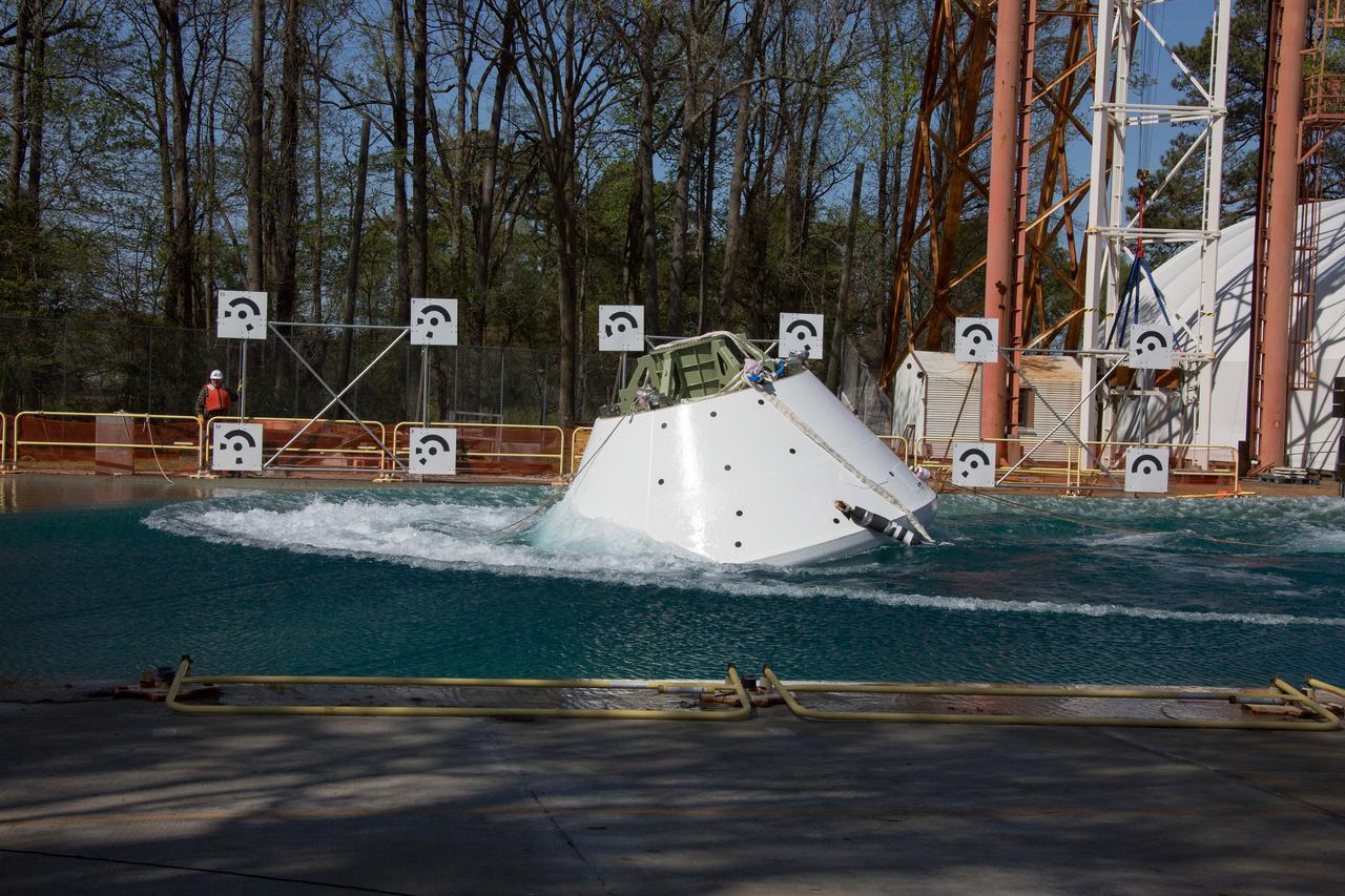
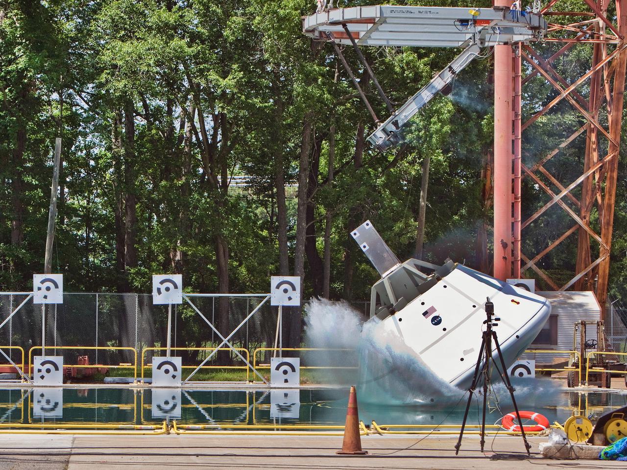
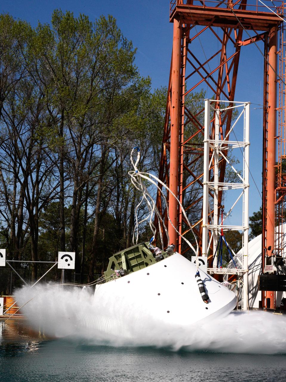
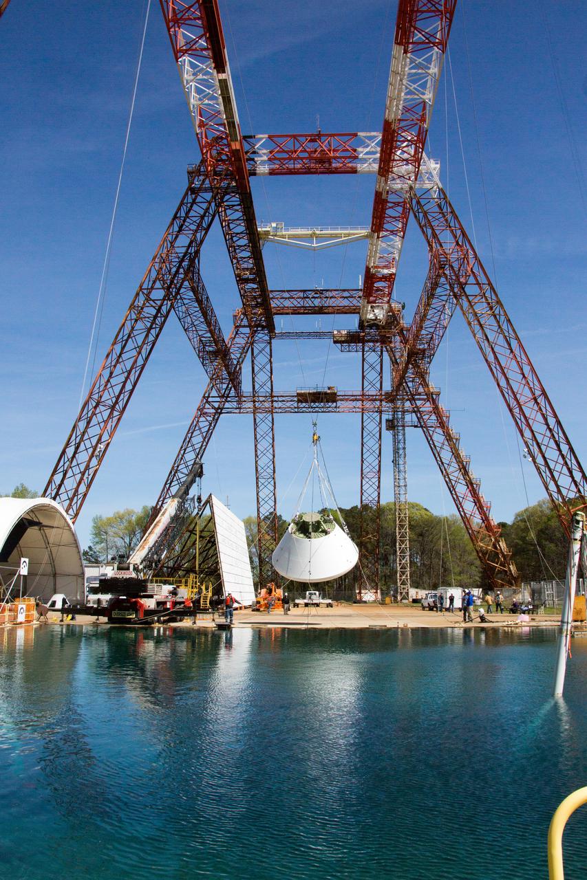
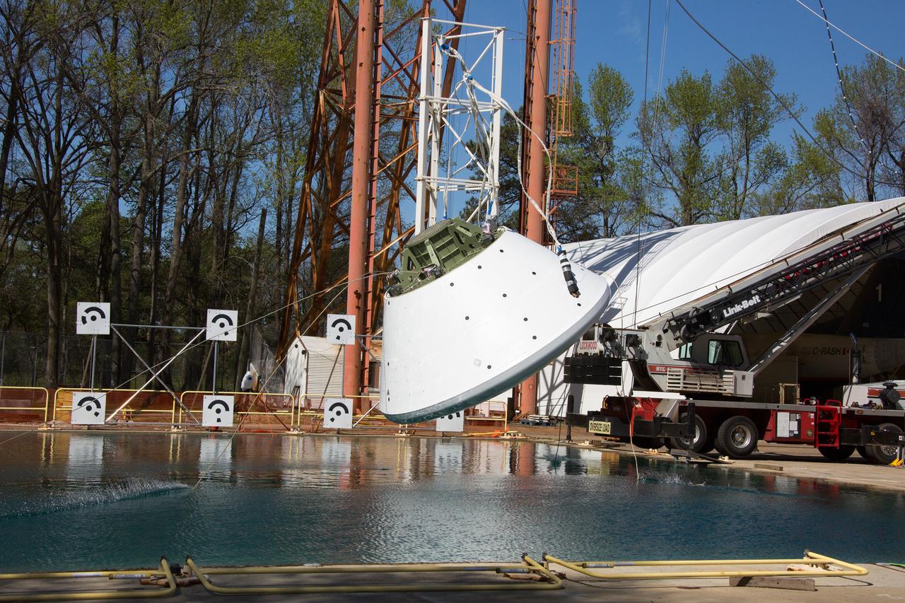
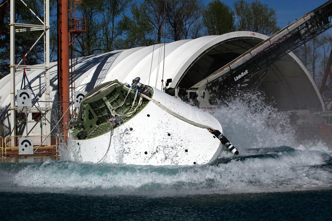
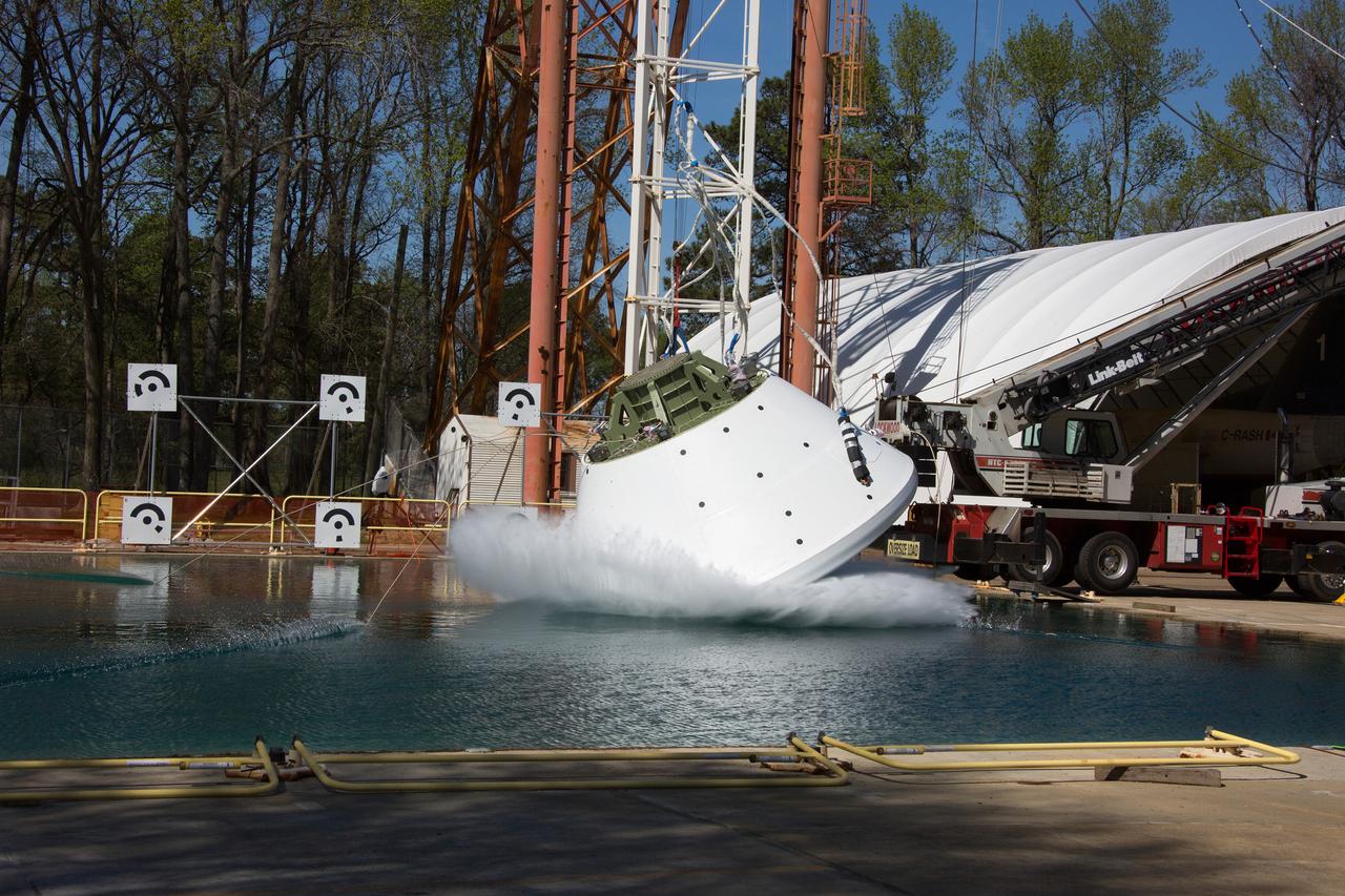
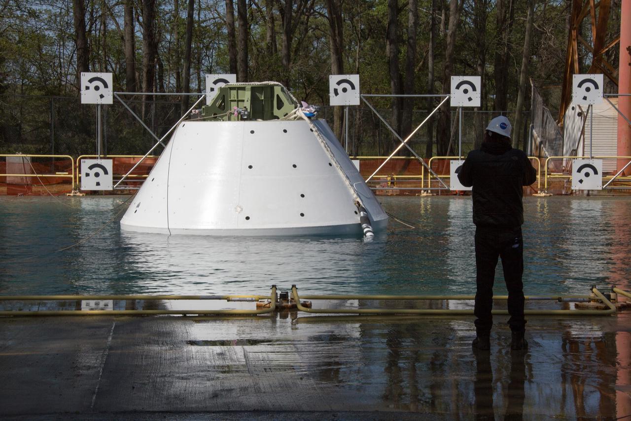
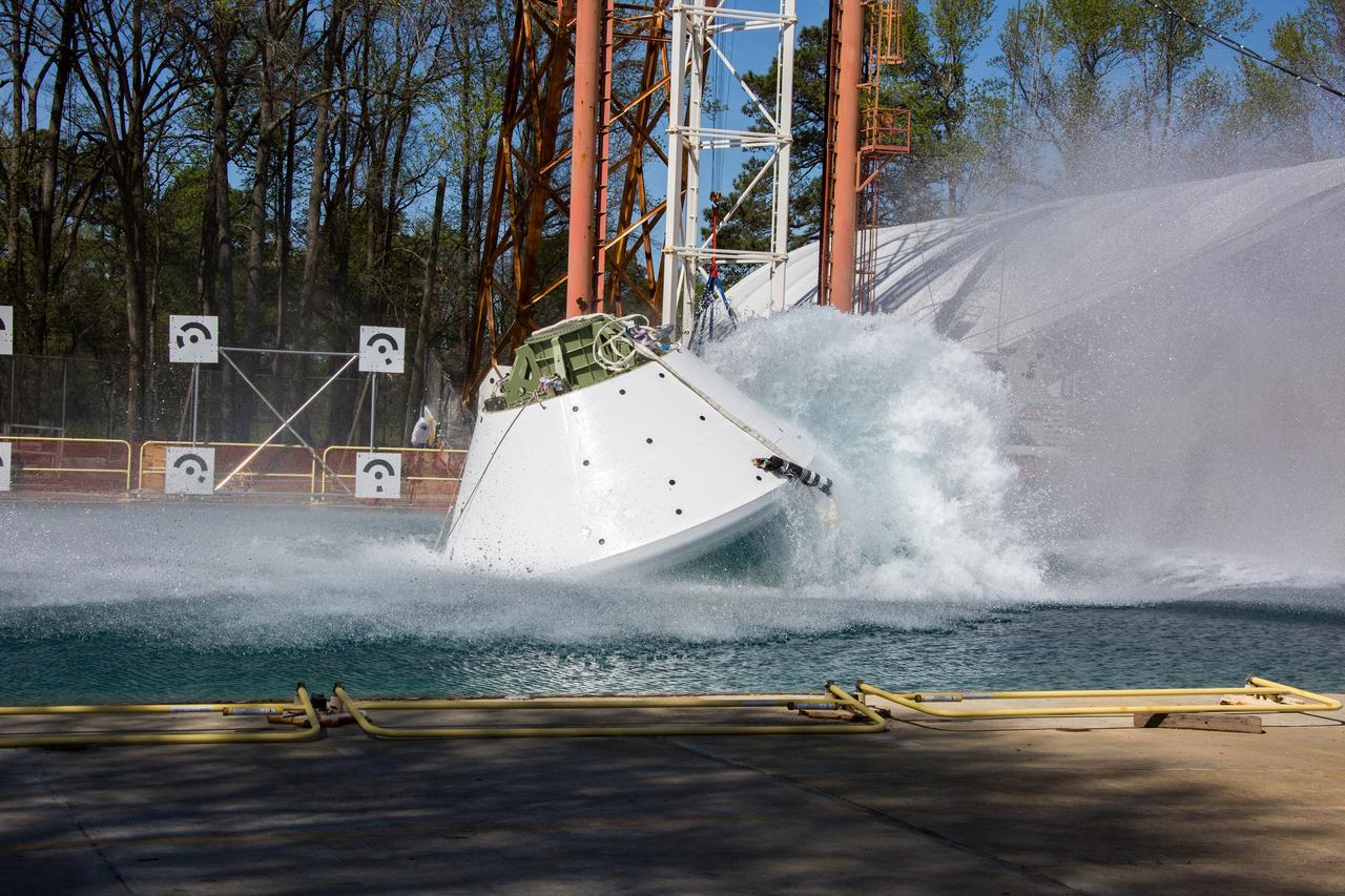
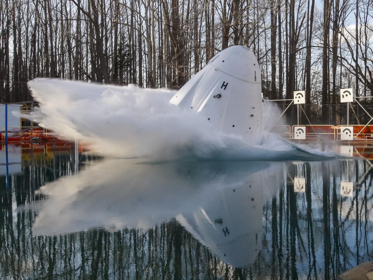
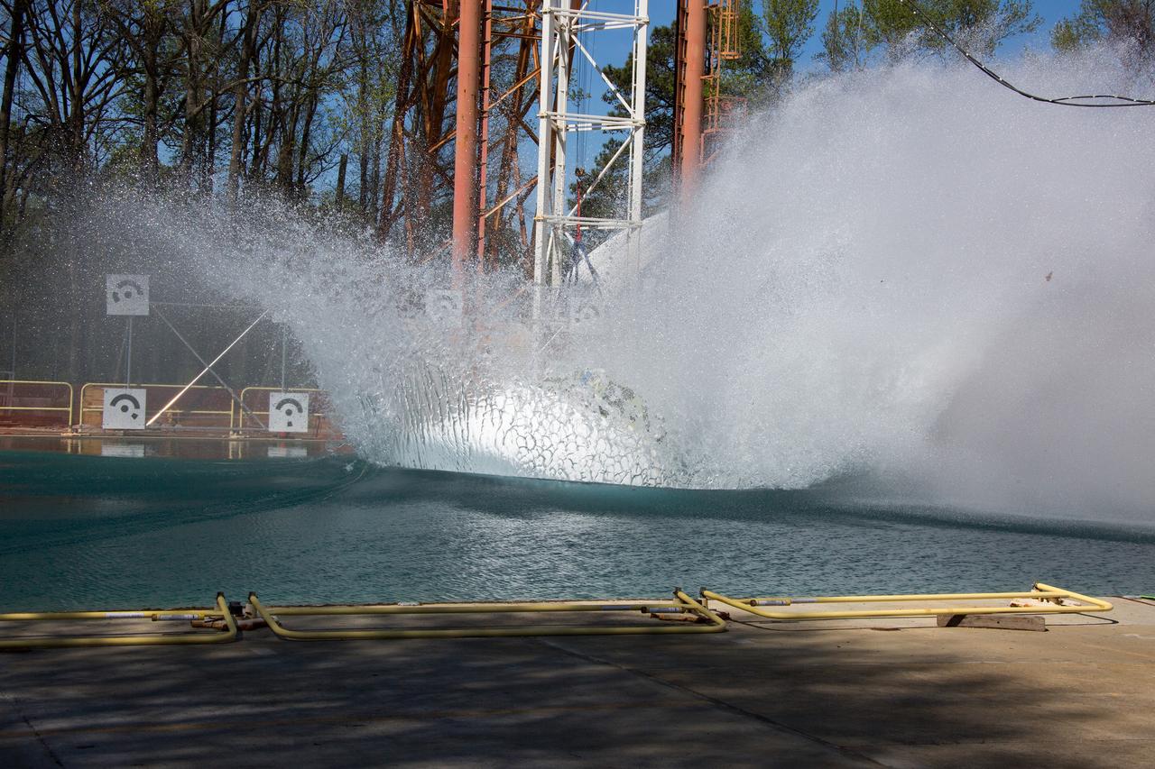
On April 6, 2016, engineers at NASA’s Langley Research Center in Hampton, Virginia, kicked off a series of nine drop tests of a representative Orion crew capsule with crash test dummies inside to understand what the spacecraft and astronauts may experience when landing in the Pacific Ocean after deep-space missions. The high-fidelity capsule, coupled with the heat shield from Orion's first flight in space, was hoisted approximately 16 feet above the water and vertically dropped into Langley’s 20-foot-deep Hydro Impact Basin. The crash test dummies were instrumented to provide data and secured inside the capsule to help provide information engineers need to ensure astronauts will be protected from injury during splashdown. Each test in the series simulates different scenarios for Orion’s parachute-assisted landings, wind conditions, velocities and wave heights the spacecraft may experience when touching down in the ocean.
On April 6, 2016, engineers at NASA’s Langley Research Center in Hampton, Virginia, kicked off a series of nine drop tests of a representative Orion crew capsule with crash test dummies inside to understand what the spacecraft and astronauts may experience when landing in the Pacific Ocean after deep-space missions. The high-fidelity capsule, coupled with the heat shield from Orion's first flight in space, was hoisted approximately 16 feet above the water and vertically dropped into Langley’s 20-foot-deep Hydro Impact Basin. The crash test dummies were instrumented to provide data and secured inside the capsule to help provide information engineers need to ensure astronauts will be protected from injury during splashdown. Each test in the series simulates different scenarios for Orion’s parachute-assisted landings, wind conditions, velocities and wave heights the spacecraft may experience when touching down in the ocean.

On April 6, 2016, engineers at NASA’s Langley Research Center in Hampton, Virginia, kicked off a series of nine drop tests of a representative Orion crew capsule with crash test dummies inside to understand what the spacecraft and astronauts may experience when landing in the Pacific Ocean after deep-space missions. The high-fidelity capsule, coupled with the heat shield from Orion's first flight in space, was hoisted approximately 16 feet above the water and vertically dropped into Langley’s 20-foot-deep Hydro Impact Basin. The crash test dummies were instrumented to provide data and secured inside the capsule to help provide information engineers need to ensure astronauts will be protected from injury during splashdown. Each test in the series simulates different scenarios for Orion’s parachute-assisted landings, wind conditions, velocities and wave heights the spacecraft may experience when touching down in the ocean.
On April 6, 2016, engineers at NASA’s Langley Research Center in Hampton, Virginia, kicked off a series of nine drop tests of a representative Orion crew capsule with crash test dummies inside to understand what the spacecraft and astronauts may experience when landing in the Pacific Ocean after deep-space missions. The high-fidelity capsule, coupled with the heat shield from Orion's first flight in space, was hoisted approximately 16 feet above the water and vertically dropped into Langley’s 20-foot-deep Hydro Impact Basin. The crash test dummies were instrumented to provide data and secured inside the capsule to help provide information engineers need to ensure astronauts will be protected from injury during splashdown. Each test in the series simulates different scenarios for Orion’s parachute-assisted landings, wind conditions, velocities and wave heights the spacecraft may experience when touching down in the ocean.
On April 6, 2016, engineers at NASA’s Langley Research Center in Hampton, Virginia, kicked off a series of nine drop tests of a representative Orion crew capsule with crash test dummies inside to understand what the spacecraft and astronauts may experience when landing in the Pacific Ocean after deep-space missions. The high-fidelity capsule, coupled with the heat shield from Orion's first flight in space, was hoisted approximately 16 feet above the water and vertically dropped into Langley’s 20-foot-deep Hydro Impact Basin. The crash test dummies were instrumented to provide data and secured inside the capsule to help provide information engineers need to ensure astronauts will be protected from injury during splashdown. Each test in the series simulates different scenarios for Orion’s parachute-assisted landings, wind conditions, velocities and wave heights the spacecraft may experience when touching down in the ocean.
On April 6, 2016, engineers at NASA’s Langley Research Center in Hampton, Virginia, kicked off a series of nine drop tests of a representative Orion crew capsule with crash test dummies inside to understand what the spacecraft and astronauts may experience when landing in the Pacific Ocean after deep-space missions. The high-fidelity capsule, coupled with the heat shield from Orion's first flight in space, was hoisted approximately 16 feet above the water and vertically dropped into Langley’s 20-foot-deep Hydro Impact Basin. The crash test dummies were instrumented to provide data and secured inside the capsule to help provide information engineers need to ensure astronauts will be protected from injury during splashdown. Each test in the series simulates different scenarios for Orion’s parachute-assisted landings, wind conditions, velocities and wave heights the spacecraft may experience when touching down in the ocean.
The Space X capsule being tested at NASA Langley’s Splash Test Basin. A series of drop tests into the Hydro Impact Basin at the Landing and Impact Research Facility at NASA’s Langley Research Center in Hampton, Virginia helped SpaceX’s Crew Dragon capsule prepare to safely land astronauts. A mock-up of the capsule with two instrumented crash test devices seated inside was tested in March 2019, representing how the capsule may impact the water during splashdown with different wind and parachute dynamics. Data collected helps understand pressures on the capsule and how those forces affect the spacecraft and occupants. Crew Dragon will carry NASA astronauts Bob Behnken and Doug Hurley to the International Space Station in the Demo-2 mission, the final SpaceX flight test for NASA’s Commercial Crew Program and the first flight of astronauts to orbit from U.S. soil since the space shuttle’s retirement in 2011. (NASA/ David C. Bowman)
On April 6, 2016, engineers at NASA’s Langley Research Center in Hampton, Virginia, kicked off a series of nine drop tests of a representative Orion crew capsule with crash test dummies inside to understand what the spacecraft and astronauts may experience when landing in the Pacific Ocean after deep-space missions. The high-fidelity capsule, coupled with the heat shield from Orion's first flight in space, was hoisted approximately 16 feet above the water and vertically dropped into Langley’s 20-foot-deep Hydro Impact Basin. The crash test dummies were instrumented to provide data and secured inside the capsule to help provide information engineers need to ensure astronauts will be protected from injury during splashdown. Each test in the series simulates different scenarios for Orion’s parachute-assisted landings, wind conditions, velocities and wave heights the spacecraft may experience when touching down in the ocean.
On April 6, 2016, engineers at NASA’s Langley Research Center in Hampton, Virginia, kicked off a series of nine drop tests of a representative Orion crew capsule with crash test dummies inside to understand what the spacecraft and astronauts may experience when landing in the Pacific Ocean after deep-space missions. The high-fidelity capsule, coupled with the heat shield from Orion's first flight in space, was hoisted approximately 16 feet above the water and vertically dropped into Langley’s 20-foot-deep Hydro Impact Basin. The crash test dummies were instrumented to provide data and secured inside the capsule to help provide information engineers need to ensure astronauts will be protected from injury during splashdown. Each test in the series simulates different scenarios for Orion’s parachute-assisted landings, wind conditions, velocities and wave heights the spacecraft may experience when touching down in the ocean.
On April 6, 2016, engineers at NASA’s Langley Research Center in Hampton, Virginia, kicked off a series of nine drop tests of a representative Orion crew capsule with crash test dummies inside to understand what the spacecraft and astronauts may experience when landing in the Pacific Ocean after deep-space missions. The high-fidelity capsule, coupled with the heat shield from Orion's first flight in space, was hoisted approximately 16 feet above the water and vertically dropped into Langley’s 20-foot-deep Hydro Impact Basin. The crash test dummies were instrumented to provide data and secured inside the capsule to help provide information engineers need to ensure astronauts will be protected from injury during splashdown. Each test in the series simulates different scenarios for Orion’s parachute-assisted landings, wind conditions, velocities and wave heights the spacecraft may experience when touching down in the ocean.
The Space X capsule being tested at NASA Langley’s Splash Test Basin. A series of drop tests into the Hydro Impact Basin at the Landing and Impact Research Facility at NASA’s Langley Research Center in Hampton, Virginia helped SpaceX’s Crew Dragon capsule prepare to safely land astronauts. A mock-up of the capsule with two instrumented crash test devices seated inside was tested in March 2019, representing how the capsule may impact the water during splashdown with different wind and parachute dynamics. Data collected helps understand pressures on the capsule and how those forces affect the spacecraft and occupants. Crew Dragon will carry NASA astronauts Bob Behnken and Doug Hurley to the International Space Station in the Demo-2 mission, the final SpaceX flight test for NASA’s Commercial Crew Program and the first flight of astronauts to orbit from U.S. soil since the space shuttle’s retirement in 2011. (NASA/ David C. Bowman)
On April 6, 2016, engineers at NASA’s Langley Research Center in Hampton, Virginia, kicked off a series of nine drop tests of a representative Orion crew capsule with crash test dummies inside to understand what the spacecraft and astronauts may experience when landing in the Pacific Ocean after deep-space missions. The high-fidelity capsule, coupled with the heat shield from Orion's first flight in space, was hoisted approximately 16 feet above the water and vertically dropped into Langley’s 20-foot-deep Hydro Impact Basin. The crash test dummies were instrumented to provide data and secured inside the capsule to help provide information engineers need to ensure astronauts will be protected from injury during splashdown. Each test in the series simulates different scenarios for Orion’s parachute-assisted landings, wind conditions, velocities and wave heights the spacecraft may experience when touching down in the ocean.
On April 6, 2016, engineers at NASA’s Langley Research Center in Hampton, Virginia, kicked off a series of nine drop tests of a representative Orion crew capsule with crash test dummies inside to understand what the spacecraft and astronauts may experience when landing in the Pacific Ocean after deep-space missions. The high-fidelity capsule, coupled with the heat shield from Orion's first flight in space, was hoisted approximately 16 feet above the water and vertically dropped into Langley’s 20-foot-deep Hydro Impact Basin. The crash test dummies were instrumented to provide data and secured inside the capsule to help provide information engineers need to ensure astronauts will be protected from injury during splashdown. Each test in the series simulates different scenarios for Orion’s parachute-assisted landings, wind conditions, velocities and wave heights the spacecraft may experience when touching down in the ocean.
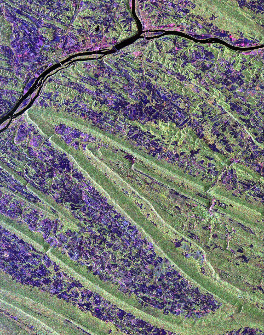
Scientists are using this radar image of the area surrounding Sunbury, Pennsylvania to study the geologic structure and land use patterns in the Appalachian Valley and Ridge province. This image was collected on October 6, 1994 by the Spaceborne Imaging Radar-C/ X-Band Synthetic Aperture Radar (SIR-C/X-SAR) on orbit 102 of the space shuttle Endeavour. The image is centered on latitude 40.85 degrees North latitude and 76.79 degrees West longitude. The area shown is approximately 30.5 km by 38 km. (19 miles by 24 miles). North is towards the upper right of the image. The Valley and Ridge province occurs in the north-central Appalachians, primarily in Pennsylvania, Maryland, and Virginia. It is an area of adjacent valleys and ridges that formed when the Appalachian mountain were created some 370 to 390 million years ago. During the continental collision that formed the Appalachians, the rocks in this area were pushed from the side and buckled much like a rug when pushed from one end. Subsequent erosion has produced the landscape we see in this image. The more resistant rocks, such as sandstone, form the tops of the ridges which appear as forested greenish areas on this image. The less resistant rocks, such as limestone, form the lower valleys which are cleared land and farm fields and are purple in this image. Smaller rivers and streams in the area flow along the valleys and in places cut across the ridges in "water gaps." In addition to defining the geography of this region, the Valley and Ridge province also provides this area with natural resources. The valleys provide fertile farmland and the folded mountains form natural traps for oil and gas accumulation; coal deposits are also found in the mountains. The colors in the image are assigned to different frequencies and polarizations of the SIR-C radar as follows: red is L-band horizontally transmitted, horizontally received; green is L-band horizontally transmitted, vertically received; blue is C-band horizontally transmitted, horizontally received. The river junction near the top of the image is where the West Branch River flows into the Susquehanna River, which then flows to the south-southwest past the state capitol of Harrisburg, 70 km (43 miles) to the south and not visible in this image. The town of Sunbury is shown along the Susquehanna on the east just to the southeast of the junction with West Branch. Three structures that cross the Susquehanna; the northern and southern of these structures are bridges and middle structure is the Shamokin Dam which confines the Susquehanna just south of the junction with West Branch. The prominent S-shaped mountain ridge in the center of the image is, from north to south, Little Mountain (the top of the S), Line Mountain (the middle of the S), and Mahantango Mountain (the bottom of the S). http://photojournal.jpl.nasa.gov/catalog/PIA01306
![The monster winter storm that brought icing to the U.S. southeast moved northward along the Eastern Seaboard and brought snow, sleet and rain from the Mid-Atlantic to New England on February 13. A new image from NOAA's GOES satellite showed clouds associated with the massive winter storm stretch from the U.S. southeast to the northeast. Data from NOAA's GOES-East satellite taken on Feb. 13 at 1455 UTC/9:45 a.m. EST were made into an image by NASA/NOAA's GOES Project at NASA's Goddard Space Flight Center in Greenbelt, Md. The clouds and fallen snow data from NOAA's GOES-East satellite were overlaid on a true-color image of land and ocean created by data from the Moderate Resolution Imaging Spectroradiometer or MODIS instrument that flies aboard NASA's Aqua and Terra satellites.The image showed that the clouds associated with the storm were blanketing much of the U.S. East Coast. At 3:11 a.m. EST, a surface map issued by the National Weather Service or NWS showed the storm's low pressure area was centered over eastern North Carolina. Since then, the low has continued to track north along the eastern seaboard. By 11 a.m. EST, precipitation from the storm was falling from South Carolina to Maine, according to National Weather Service radar. By 11 a.m. EST, the Washington, D.C. region snow and sleet totals ranged from 3" in far eastern Maryland to over 18" in the northern and western suburbs in Maryland and Virginia. NWS reported that snow, sleet and rain were still falling and more snow is expected as the back side of the low moves into the region. The New York City region remained under an NWS Winter Storm Warning until 6 a.m. on Friday, February 14 and the National Weather Service expects minor coastal impacts Thursday into Friday afternoon. New England was also being battered by the storm. At 10:56 a.m. EST, Barnstable, Mass. on Cape Cod was experiencing rain and winds gusting to 28 mph. An NWS wind advisory is in effect for Cape Cod until 7 p.m. EST. Further north, Portland, Maine was experiencing heavy snow with winds from the northeast at 6 mph. The National Weather Service in Gray, Maine noted "Significant snowfall is likely for much of western Maine and New Hampshire as this storm passes by. There will be a mix or changeover to sleet and freezing rain over southern and coastal sections tonight...before all areas end as a period of snow Friday (Feb. 14) morning." On February 13 at 10 a.m. EST, NOAA's National Weather Service noted "An abundance of Atlantic moisture getting wrapped into the storm will continue to fuel widespread precipitation...which should lift through the Mid-Atlantic States and Northeast Thursday into Friday. A wide swath of heavy snow accumulations are expected with this storm...but air [moving] off the warmer ocean water should change snow over to rain along the coastal areas. Also...a narrow axis of sleet and freezing rain will be possible within the transition zone...which is expected to set up near the I-95 corridor." For updates on local forecasts, watches and warnings, visit NOAA's <a href="http://www.weather.gov" rel="nofollow">www.weather.gov</a> webpage. GOES satellites provide the kind of continuous monitoring necessary for intensive data analysis. Geostationary describes an orbit in which a satellite is always in the same position with respect to the rotating Earth. This allows GOES to hover continuously over one position on Earth's surface, appearing stationary. As a result, GOES provide a constant vigil for the atmospheric "triggers" for severe weather conditions such as tornadoes, flash floods, hail storms and hurricanes. For updated information about the storm system, visit NOAA's WPC website: <a href="http://www.hpc.ncep.noaa.gov/" rel="nofollow">www.hpc.ncep.noaa.gov/</a> For more information about GOES satellites, visit: <a href="http://www.goes.noaa.gov/" rel="nofollow">www.goes.noaa.gov/</a> or <a href="http://goes.gsfc.nasa.gov/" rel="nofollow">goes.gsfc.nasa.gov/</a> Credit: NASA/GSFC/Jeff Schmaltz/MODIS Land Rapid Response Team <b><a href="http://www.nasa.gov/audience/formedia/features/MP_Photo_Guidelines.html" rel="nofollow">NASA image use policy.</a></b> <b><a href="http://www.nasa.gov/centers/goddard/home/index.html" rel="nofollow">NASA Goddard Space Flight Center</a></b> enables NASA’s mission through four scientific endeavors: Earth Science, Heliophysics, Solar System Exploration, and Astrophysics. Goddard plays a leading role in NASA’s accomplishments by contributing compelling scientific knowledge to advance the Agency’s mission. <b>Follow us on <a href="http://twitter.com/NASAGoddardPix" rel="nofollow">Twitter</a></b> <b>Like us on <a href="http://www.facebook.com/pages/Greenbelt-MD/NASA-Goddard/395013845897?ref=tsd" rel="nofollow">Facebook</a></b> <b>Find us on <a href="http://instagram.com/nasagoddard?vm=grid" rel="nofollow">Instagram</a></b>](https://images-assets.nasa.gov/image/GSFC_20171208_Archive_e001229/GSFC_20171208_Archive_e001229~medium.jpg)
The monster winter storm that brought icing to the U.S. southeast moved northward along the Eastern Seaboard and brought snow, sleet and rain from the Mid-Atlantic to New England on February 13. A new image from NOAA's GOES satellite showed clouds associated with the massive winter storm stretch from the U.S. southeast to the northeast. Data from NOAA's GOES-East satellite taken on Feb. 13 at 1455 UTC/9:45 a.m. EST were made into an image by NASA/NOAA's GOES Project at NASA's Goddard Space Flight Center in Greenbelt, Md. The clouds and fallen snow data from NOAA's GOES-East satellite were overlaid on a true-color image of land and ocean created by data from the Moderate Resolution Imaging Spectroradiometer or MODIS instrument that flies aboard NASA's Aqua and Terra satellites.The image showed that the clouds associated with the storm were blanketing much of the U.S. East Coast. At 3:11 a.m. EST, a surface map issued by the National Weather Service or NWS showed the storm's low pressure area was centered over eastern North Carolina. Since then, the low has continued to track north along the eastern seaboard. By 11 a.m. EST, precipitation from the storm was falling from South Carolina to Maine, according to National Weather Service radar. By 11 a.m. EST, the Washington, D.C. region snow and sleet totals ranged from 3" in far eastern Maryland to over 18" in the northern and western suburbs in Maryland and Virginia. NWS reported that snow, sleet and rain were still falling and more snow is expected as the back side of the low moves into the region. The New York City region remained under an NWS Winter Storm Warning until 6 a.m. on Friday, February 14 and the National Weather Service expects minor coastal impacts Thursday into Friday afternoon. New England was also being battered by the storm. At 10:56 a.m. EST, Barnstable, Mass. on Cape Cod was experiencing rain and winds gusting to 28 mph. An NWS wind advisory is in effect for Cape Cod until 7 p.m. EST. Further north, Portland, Maine was experiencing heavy snow with winds from the northeast at 6 mph. The National Weather Service in Gray, Maine noted "Significant snowfall is likely for much of western Maine and New Hampshire as this storm passes by. There will be a mix or changeover to sleet and freezing rain over southern and coastal sections tonight...before all areas end as a period of snow Friday (Feb. 14) morning." On February 13 at 10 a.m. EST, NOAA's National Weather Service noted "An abundance of Atlantic moisture getting wrapped into the storm will continue to fuel widespread precipitation...which should lift through the Mid-Atlantic States and Northeast Thursday into Friday. A wide swath of heavy snow accumulations are expected with this storm...but air [moving] off the warmer ocean water should change snow over to rain along the coastal areas. Also...a narrow axis of sleet and freezing rain will be possible within the transition zone...which is expected to set up near the I-95 corridor." For updates on local forecasts, watches and warnings, visit NOAA's <a href="http://www.weather.gov" rel="nofollow">www.weather.gov</a> webpage. GOES satellites provide the kind of continuous monitoring necessary for intensive data analysis. Geostationary describes an orbit in which a satellite is always in the same position with respect to the rotating Earth. This allows GOES to hover continuously over one position on Earth's surface, appearing stationary. As a result, GOES provide a constant vigil for the atmospheric "triggers" for severe weather conditions such as tornadoes, flash floods, hail storms and hurricanes. For updated information about the storm system, visit NOAA's WPC website: <a href="http://www.hpc.ncep.noaa.gov/" rel="nofollow">www.hpc.ncep.noaa.gov/</a> For more information about GOES satellites, visit: <a href="http://www.goes.noaa.gov/" rel="nofollow">www.goes.noaa.gov/</a> or <a href="http://goes.gsfc.nasa.gov/" rel="nofollow">goes.gsfc.nasa.gov/</a> Credit: NASA/GSFC/Jeff Schmaltz/MODIS Land Rapid Response Team <b><a href="http://www.nasa.gov/audience/formedia/features/MP_Photo_Guidelines.html" rel="nofollow">NASA image use policy.</a></b> <b><a href="http://www.nasa.gov/centers/goddard/home/index.html" rel="nofollow">NASA Goddard Space Flight Center</a></b> enables NASA’s mission through four scientific endeavors: Earth Science, Heliophysics, Solar System Exploration, and Astrophysics. Goddard plays a leading role in NASA’s accomplishments by contributing compelling scientific knowledge to advance the Agency’s mission. <b>Follow us on <a href="http://twitter.com/NASAGoddardPix" rel="nofollow">Twitter</a></b> <b>Like us on <a href="http://www.facebook.com/pages/Greenbelt-MD/NASA-Goddard/395013845897?ref=tsd" rel="nofollow">Facebook</a></b> <b>Find us on <a href="http://instagram.com/nasagoddard?vm=grid" rel="nofollow">Instagram</a></b>
![The monster winter storm that brought icing to the U.S. southeast moved northward along the Eastern Seaboard and brought snow, sleet and rain from the Mid-Atlantic to New England on February 13. A new image from NOAA's GOES satellite showed clouds associated with the massive winter storm stretch from the U.S. southeast to the northeast. Data from NOAA's GOES-East satellite taken on Feb. 13 at 1455 UTC/9:45 a.m. EST were made into an image by NASA/NOAA's GOES Project at NASA's Goddard Space Flight Center in Greenbelt, Md. The clouds and fallen snow data from NOAA's GOES-East satellite were overlaid on a true-color image of land and ocean created by data from the Moderate Resolution Imaging Spectroradiometer or MODIS instrument that flies aboard NASA's Aqua and Terra satellites.The image showed that the clouds associated with the storm were blanketing much of the U.S. East Coast. At 3:11 a.m. EST, a surface map issued by the National Weather Service or NWS showed the storm's low pressure area was centered over eastern North Carolina. Since then, the low has continued to track north along the eastern seaboard. By 11 a.m. EST, precipitation from the storm was falling from South Carolina to Maine, according to National Weather Service radar. By 11 a.m. EST, the Washington, D.C. region snow and sleet totals ranged from 3" in far eastern Maryland to over 18" in the northern and western suburbs in Maryland and Virginia. NWS reported that snow, sleet and rain were still falling and more snow is expected as the back side of the low moves into the region. The New York City region remained under an NWS Winter Storm Warning until 6 a.m. on Friday, February 14 and the National Weather Service expects minor coastal impacts Thursday into Friday afternoon. New England was also being battered by the storm. At 10:56 a.m. EST, Barnstable, Mass. on Cape Cod was experiencing rain and winds gusting to 28 mph. An NWS wind advisory is in effect for Cape Cod until 7 p.m. EST. Further north, Portland, Maine was experiencing heavy snow with winds from the northeast at 6 mph. The National Weather Service in Gray, Maine noted "Significant snowfall is likely for much of western Maine and New Hampshire as this storm passes by. There will be a mix or changeover to sleet and freezing rain over southern and coastal sections tonight...before all areas end as a period of snow Friday (Feb. 14) morning." On February 13 at 10 a.m. EST, NOAA's National Weather Service noted "An abundance of Atlantic moisture getting wrapped into the storm will continue to fuel widespread precipitation...which should lift through the Mid-Atlantic States and Northeast Thursday into Friday. A wide swath of heavy snow accumulations are expected with this storm...but air [moving] off the warmer ocean water should change snow over to rain along the coastal areas. Also...a narrow axis of sleet and freezing rain will be possible within the transition zone...which is expected to set up near the I-95 corridor." For updates on local forecasts, watches and warnings, visit NOAA's <a href="http://www.weather.gov" rel="nofollow">www.weather.gov</a> webpage. GOES satellites provide the kind of continuous monitoring necessary for intensive data analysis. Geostationary describes an orbit in which a satellite is always in the same position with respect to the rotating Earth. This allows GOES to hover continuously over one position on Earth's surface, appearing stationary. As a result, GOES provide a constant vigil for the atmospheric "triggers" for severe weather conditions such as tornadoes, flash floods, hail storms and hurricanes. For updated information about the storm system, visit NOAA's WPC website: <a href="http://www.hpc.ncep.noaa.gov/" rel="nofollow">www.hpc.ncep.noaa.gov/</a> For more information about GOES satellites, visit: <a href="http://www.goes.noaa.gov/" rel="nofollow">www.goes.noaa.gov/</a> or <a href="http://goes.gsfc.nasa.gov/" rel="nofollow">goes.gsfc.nasa.gov/</a> Credit: NASA/GSFC/Jeff Schmaltz/MODIS Land Rapid Response Team <b><a href="http://www.nasa.gov/audience/formedia/features/MP_Photo_Guidelines.html" rel="nofollow">NASA image use policy.</a></b> <b><a href="http://www.nasa.gov/centers/goddard/home/index.html" rel="nofollow">NASA Goddard Space Flight Center</a></b> enables NASA’s mission through four scientific endeavors: Earth Science, Heliophysics, Solar System Exploration, and Astrophysics. Goddard plays a leading role in NASA’s accomplishments by contributing compelling scientific knowledge to advance the Agency’s mission. <b>Follow us on <a href="http://twitter.com/NASAGoddardPix" rel="nofollow">Twitter</a></b> <b>Like us on <a href="http://www.facebook.com/pages/Greenbelt-MD/NASA-Goddard/395013845897?ref=tsd" rel="nofollow">Facebook</a></b> <b>Find us on <a href="http://instagram.com/nasagoddard?vm=grid" rel="nofollow">Instagram</a></b>](https://images-assets.nasa.gov/image/GSFC_20171208_Archive_e001228/GSFC_20171208_Archive_e001228~medium.jpg)
The monster winter storm that brought icing to the U.S. southeast moved northward along the Eastern Seaboard and brought snow, sleet and rain from the Mid-Atlantic to New England on February 13. A new image from NOAA's GOES satellite showed clouds associated with the massive winter storm stretch from the U.S. southeast to the northeast. Data from NOAA's GOES-East satellite taken on Feb. 13 at 1455 UTC/9:45 a.m. EST were made into an image by NASA/NOAA's GOES Project at NASA's Goddard Space Flight Center in Greenbelt, Md. The clouds and fallen snow data from NOAA's GOES-East satellite were overlaid on a true-color image of land and ocean created by data from the Moderate Resolution Imaging Spectroradiometer or MODIS instrument that flies aboard NASA's Aqua and Terra satellites.The image showed that the clouds associated with the storm were blanketing much of the U.S. East Coast. At 3:11 a.m. EST, a surface map issued by the National Weather Service or NWS showed the storm's low pressure area was centered over eastern North Carolina. Since then, the low has continued to track north along the eastern seaboard. By 11 a.m. EST, precipitation from the storm was falling from South Carolina to Maine, according to National Weather Service radar. By 11 a.m. EST, the Washington, D.C. region snow and sleet totals ranged from 3" in far eastern Maryland to over 18" in the northern and western suburbs in Maryland and Virginia. NWS reported that snow, sleet and rain were still falling and more snow is expected as the back side of the low moves into the region. The New York City region remained under an NWS Winter Storm Warning until 6 a.m. on Friday, February 14 and the National Weather Service expects minor coastal impacts Thursday into Friday afternoon. New England was also being battered by the storm. At 10:56 a.m. EST, Barnstable, Mass. on Cape Cod was experiencing rain and winds gusting to 28 mph. An NWS wind advisory is in effect for Cape Cod until 7 p.m. EST. Further north, Portland, Maine was experiencing heavy snow with winds from the northeast at 6 mph. The National Weather Service in Gray, Maine noted "Significant snowfall is likely for much of western Maine and New Hampshire as this storm passes by. There will be a mix or changeover to sleet and freezing rain over southern and coastal sections tonight...before all areas end as a period of snow Friday (Feb. 14) morning." On February 13 at 10 a.m. EST, NOAA's National Weather Service noted "An abundance of Atlantic moisture getting wrapped into the storm will continue to fuel widespread precipitation...which should lift through the Mid-Atlantic States and Northeast Thursday into Friday. A wide swath of heavy snow accumulations are expected with this storm...but air [moving] off the warmer ocean water should change snow over to rain along the coastal areas. Also...a narrow axis of sleet and freezing rain will be possible within the transition zone...which is expected to set up near the I-95 corridor." For updates on local forecasts, watches and warnings, visit NOAA's <a href="http://www.weather.gov" rel="nofollow">www.weather.gov</a> webpage. GOES satellites provide the kind of continuous monitoring necessary for intensive data analysis. Geostationary describes an orbit in which a satellite is always in the same position with respect to the rotating Earth. This allows GOES to hover continuously over one position on Earth's surface, appearing stationary. As a result, GOES provide a constant vigil for the atmospheric "triggers" for severe weather conditions such as tornadoes, flash floods, hail storms and hurricanes. For updated information about the storm system, visit NOAA's WPC website: <a href="http://www.hpc.ncep.noaa.gov/" rel="nofollow">www.hpc.ncep.noaa.gov/</a> For more information about GOES satellites, visit: <a href="http://www.goes.noaa.gov/" rel="nofollow">www.goes.noaa.gov/</a> or <a href="http://goes.gsfc.nasa.gov/" rel="nofollow">goes.gsfc.nasa.gov/</a> Credit: NASA/GSFC/Jeff Schmaltz/MODIS Land Rapid Response Team <b><a href="http://www.nasa.gov/audience/formedia/features/MP_Photo_Guidelines.html" rel="nofollow">NASA image use policy.</a></b> <b><a href="http://www.nasa.gov/centers/goddard/home/index.html" rel="nofollow">NASA Goddard Space Flight Center</a></b> enables NASA’s mission through four scientific endeavors: Earth Science, Heliophysics, Solar System Exploration, and Astrophysics. Goddard plays a leading role in NASA’s accomplishments by contributing compelling scientific knowledge to advance the Agency’s mission. <b>Follow us on <a href="http://twitter.com/NASAGoddardPix" rel="nofollow">Twitter</a></b> <b>Like us on <a href="http://www.facebook.com/pages/Greenbelt-MD/NASA-Goddard/395013845897?ref=tsd" rel="nofollow">Facebook</a></b> <b>Find us on <a href="http://instagram.com/nasagoddard?vm=grid" rel="nofollow">Instagram</a></b>