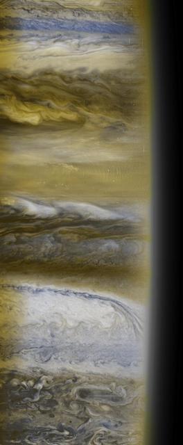
This is a composite of several images taken in several colors by the New Horizons Multispectral Visual Imaging Camera, or MVIC.
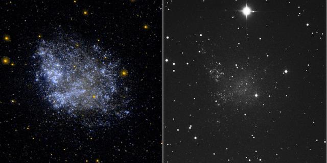
This ultraviolet image left and visual image right from NASA Galaxy Evolution Explorer is of the irregular dwarf galaxy IC 1613.
This ultraviolet image from NASA Galaxy Evolution Explorer left and visual image right of the face on barred and ringed spiral galaxy NGC 3351 M95.
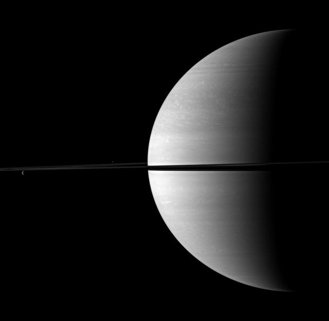
Rhea and Enceladus appear above and below the rings on the left of this image, serving to visually offset the dominance of Saturn in this image taken by NASA Cassini spacecraft.
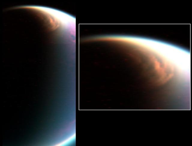
Cassini visual and infrared mapping spectrometer has imaged a huge cloud system covering the north pole of Titan
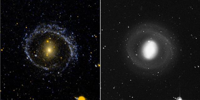
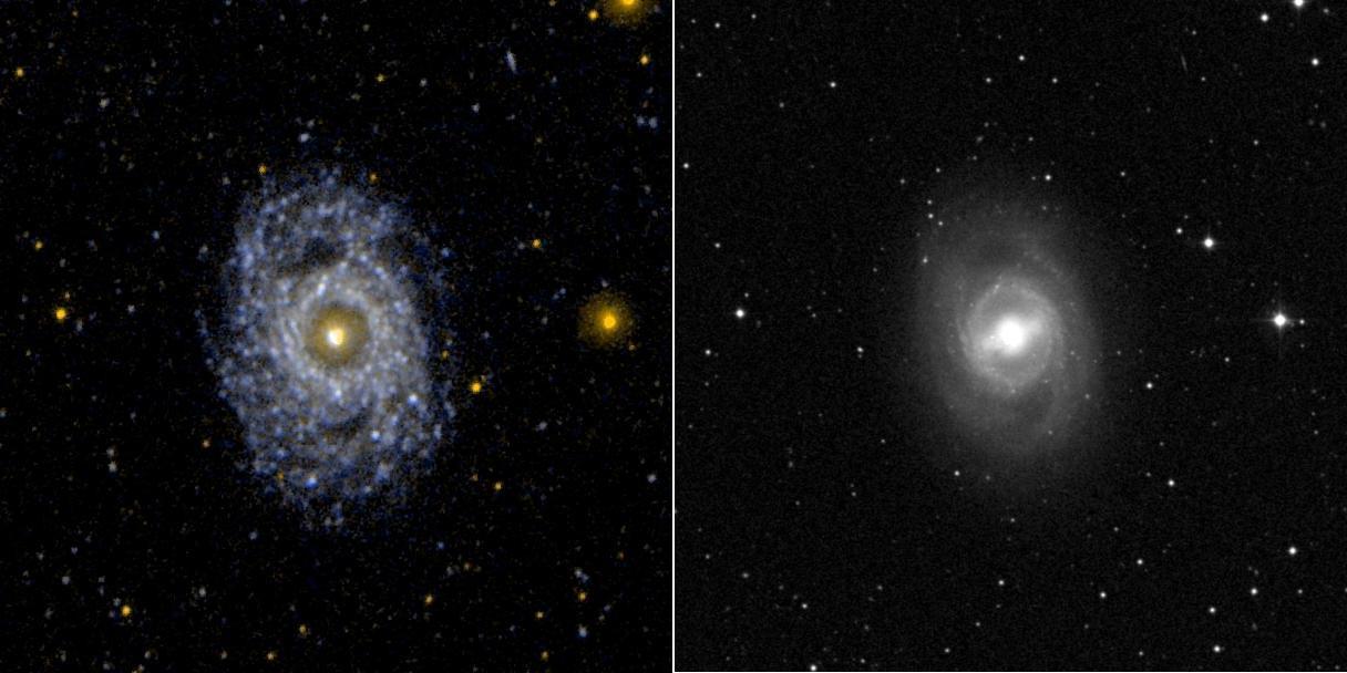
This ultraviolet image left and visual image right from NASA Galaxy Evolution Explorer is of the barred ring galaxy NGC 1291. The VIS image is dominated by the inner disk and bar. The UV image is dominated by the low surface brightness outer arms.
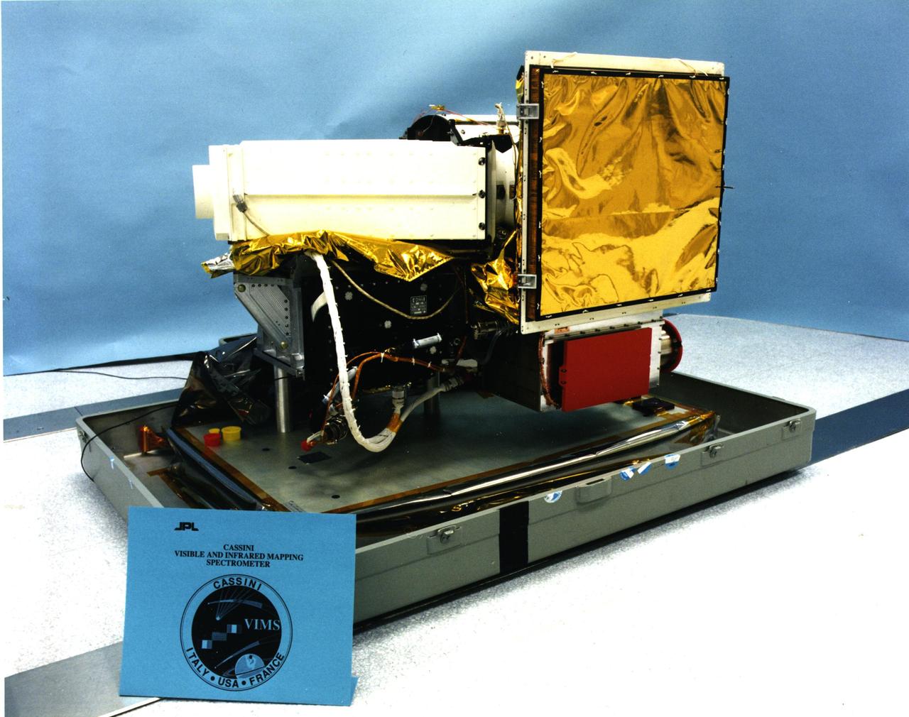
This image shows the visual and infrared mapping spectrometer instrument just before it was attached to NASA Cassini spacecraft. Cassini launched in 1997 and has been exploring the Saturn system since 2004.
This visual and infrared mapping spectrometer image captured by NASA Cassini spacecraft of Saturn moon Enceladus, shows the dark cracks at the south pole dubbed tiger stripes for their distinct stripe-like appearance.
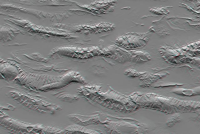
The Zagros Mountains in Iran offer a visually stunning topographic display of geologic structure in layered sedimentary rocks in this anaglyph from NASA Shuttle Radar Topography Mission. 3D glasses are necessary to view this image.
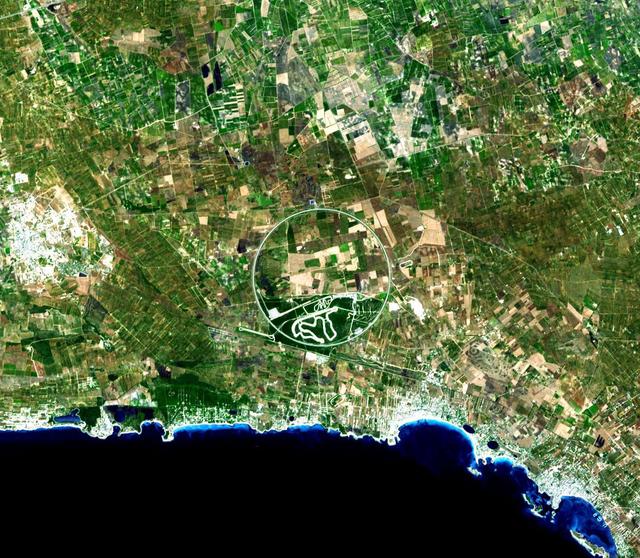
The Nardò Ring is a striking visual feature from space, and astronauts have photographed it several times. The Ring is a race car test track in Italy. This image was acquired by NASA Terra satellite on August 17. 2007.
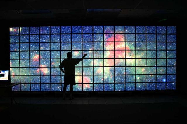
The center of the Milky Way galaxy imaged by NASA Spitzer Space Telescope is displayed on a quarter-of-a-billion-pixel, high-definition 23-foot-wide 7-meter LCD science visualization screen at NASA Ames Research Center.
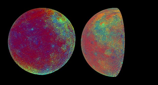
These color visualizations of the Moon were obtained by NASA Galileo spacecraft as it left the Earth after completing its first Earth Gravity Assist. The images were acquired Dec. 8-9, 1990. http://photojournal.jpl.nasa.gov/catalog/PIA00075

As winter turns to spring at the south polar ice cap of Mars, the rising sun reveals dark spots and fans emerging from the cold polar night. Using visual images left and temperature data right
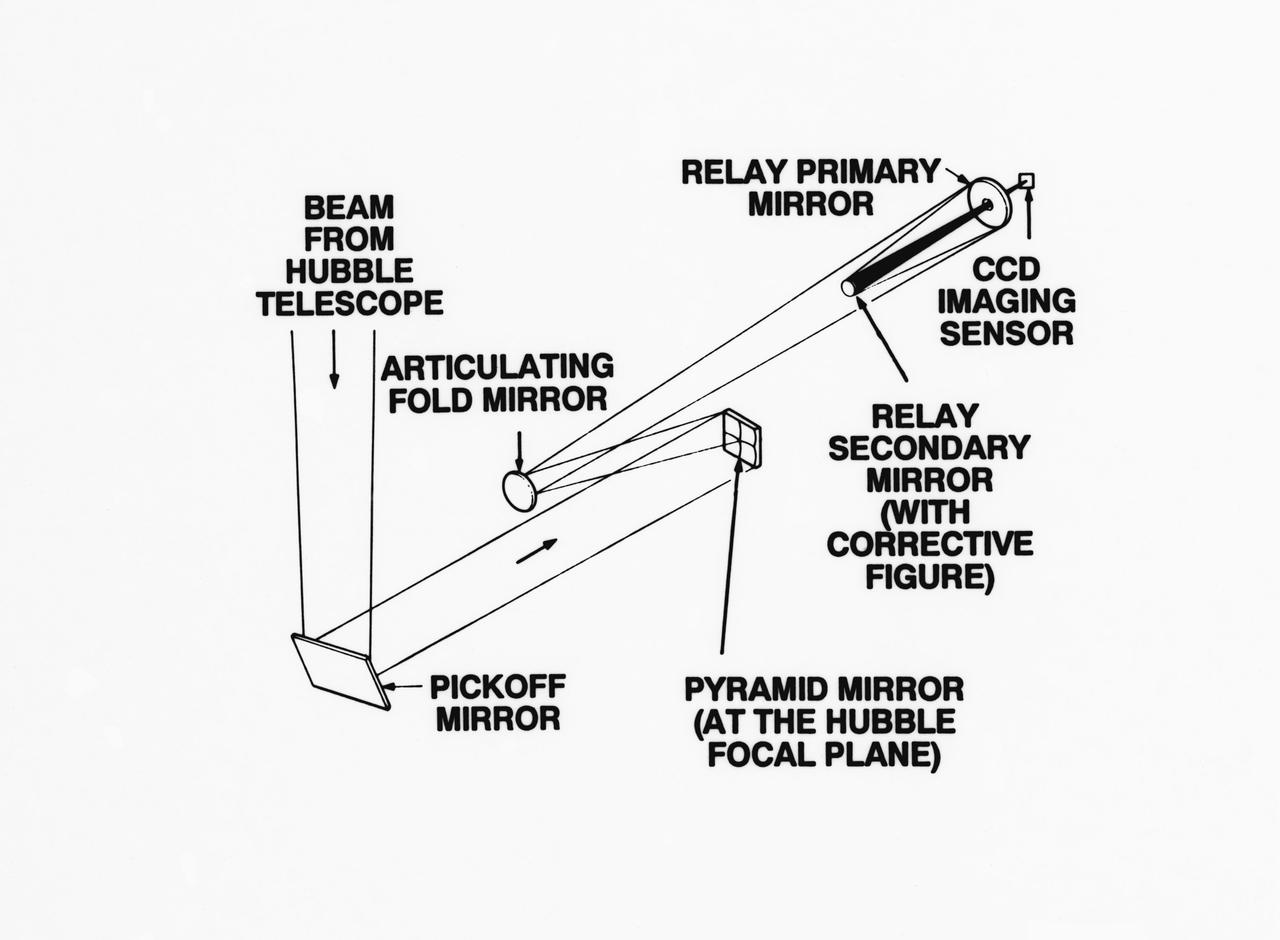
S93-33258 (15 Mar 1993) --- An optical schematic diagram of one of the four channels of the Wide Field\Planetary Camera-2 (WF\PC-2) shows the path taken by beams from the Hubble Space Telescope (HST) before an image is formed at the camera's charge-coupled devices. A team of NASA astronauts will pay a visit to the HST later this year, carrying with them the new WF/PC-2 to replace the one currently on the HST. The Jet Propulsion Laboratory in Pasadena, California has been working on the replacement system for several months. See NASA photo S93-33257 for a close-up view of tiny articulating mirrors designed to realign incoming light in order to make certain the beams fall precisely in the middle of the secondary mirrors.
This image showcases both the visible and infrared visualizations of the Orion Nebula. This view from a movie sequence looks down the 'valley' leading to the star cluster at the far end. The left side of the image shows the visible-light visualization, which fades to the infrared-light visualization on the right. These two contrasting models derive from observations by the Hubble and Spitzer space telescopes. An animation is available at https://photojournal.jpl.nasa.gov/catalog/PIA22089
This global map elliptical map from NASA Dawn spacecraft shows the surface of Ceres in enhanced color, encompassing infrared wavelengths beyond human visual range. Some areas near the poles are black where Dawn color imaging coverage is incomplete.
The most visually striking feature on Saturn's icy moon Tethys is Odysseus crater. An enormous impact created the crater, which is about 280 miles (450 kilometers) across, with its ring of steep cliffs and the mountains that rise at its center. Odysseus is on the leading hemisphere of Tethys (1,071 kilometers, or 665 miles across). In this image, north on Tethys is up. This view is a composite of several images taken in visible light with the Cassini spacecraft narrow-angle camera on Aug. 17, 2015, at a distance of about 28,000 miles (44,500 kilometers) from Tethys. The Cassini spacecraft ended its mission on Sept. 15, 2017 https://photojournal.jpl.nasa.gov/catalog/PIA21613
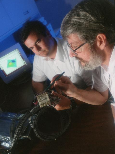
Researchers at Marshall's Space Science Laboratory successfully demonstrate that linear arrays of Hall probes can be constructed in high Hall coefficient films and used to digitally image magnetic fields. This research is beneficial to visually imaging any magnetic field.
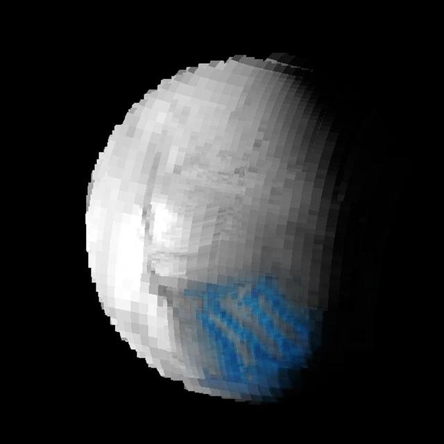
Cassini made a close flyby of Saturn's moon Iapetus on Sept. 10, 2007, and the visual and infrared mapping spectrometer obtained these images during that event. These two images show a higher resolution version of the equatorial region shown in PIA10010. The equatorial region includes the equatorial bulge which shows no differences in these compositions compared to surrounding regions. The color image on the right shows the results of mapping for three components of Iapetus' surface: carbon dioxide that is trapped or adsorbed in the surface (red), water in the form of ice (green), and a newly-discovered effect due to trace amount of dark particles in the ice creating what scientists call Rayleigh scattering (blue). The Rayleigh scattering effect is the main reason why the Earth's sky appears blue. There is a complex transition zone from the dark region, on the right, which is high in carbon dioxide, to the more ice-rich region on the left. Some crater floors are filled with carbon dioxide-rich dark material. As the ice becomes cleaner to the left, the small dark particles become more scattered and increase the Rayleigh scattering effect, again indicative of less than 2 percent dark sub-0.5-micron particles. The visual and infrared mapping spectrometer is like a digital camera, but instead of using three colors, it makes images in 352 colors, or wavelengths, from the ultraviolet to the near-infrared. The many wavelengths produce a continuous spectrum in each pixel, and these spectra measure how light is absorbed by different materials. By analyzing the absorptions expressed in each pixel, a map of the composition at each location on the moon can be constructed. http://photojournal.jpl.nasa.gov/catalog/PIA10011
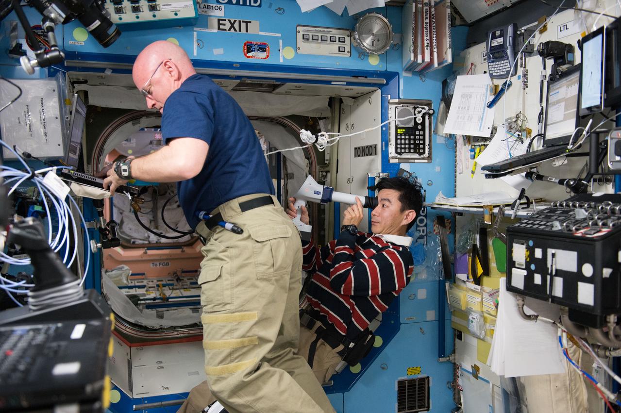
ISS044E033352 (08/05/2015) --- NASA astronaut Scott Kelly (left) assists Japan Aerospace Exploration Agency (JAXA) astronaut Kimiya Yui (right) with measurements for the ongoing Ocular Health study. Yui is seen operating a device called a Fundoscope which is used to take images of the retinal surface of an astronaut’s eye. Ocular Health is gathering data on crew visual health during and after long-duration space station missions to characterize how living in microgravity can affect the visual, vascular and central nervous systems.

These images of the world were generated with data from the Shuttle Radar Topography Mission (SRTM). The SRTM Project has recently released a new global data set called SRTM30, where the original one arcsecond of latitude and longitude resolution (about 30 meters, or 98 feet, at the equator) was reduced to 30 arcseconds (about 928 meters, or 1496 feet.) These images were created from that data set and show the Earth as it would be viewed from a point in space centered over the Americas, Africa and the western Pacific. Two visualization methods were combined to produce the image: shading and color coding of topographic height. The shade image was derived by computing topographic slope in the northwest-southeast direction, so that northwest slopes appear bright and southeast slopes appear dark. Color coding is directly related to topographic height, with green at the lower elevations, rising through yellow and tan, to white at the highest elevations. Elevation data used in this image were acquired by the Shuttle Radar Topography Mission aboard the Space Shuttle Endeavour, launched on Feb. 11, 2000. http://photojournal.jpl.nasa.gov/catalog/PIA03394
This montage of images, made from data obtained by Cassini's visual and infrared mapping spectrometer, shows the location on Saturn where the NASA spacecraft entered Saturn's atmosphere on Sept. 15, 2017. This view shows Saturn in the thermal infrared, at a wavelength of 5 microns. Here, the instrument is sensing heat coming from Saturn's interior, in red. Clouds in the atmosphere are silhouetted against that inner glow. This location -- the site of Cassini's atmospheric entry -- was at this time on the night side of the planet, but would rotate into daylight by the time Cassini made its final dive into Saturn's upper atmosphere, ending its remarkable 13-year exploration of Saturn. Both an annotated version and an animation are available at https://photojournal.jpl.nasa.gov/catalog/PIA21896
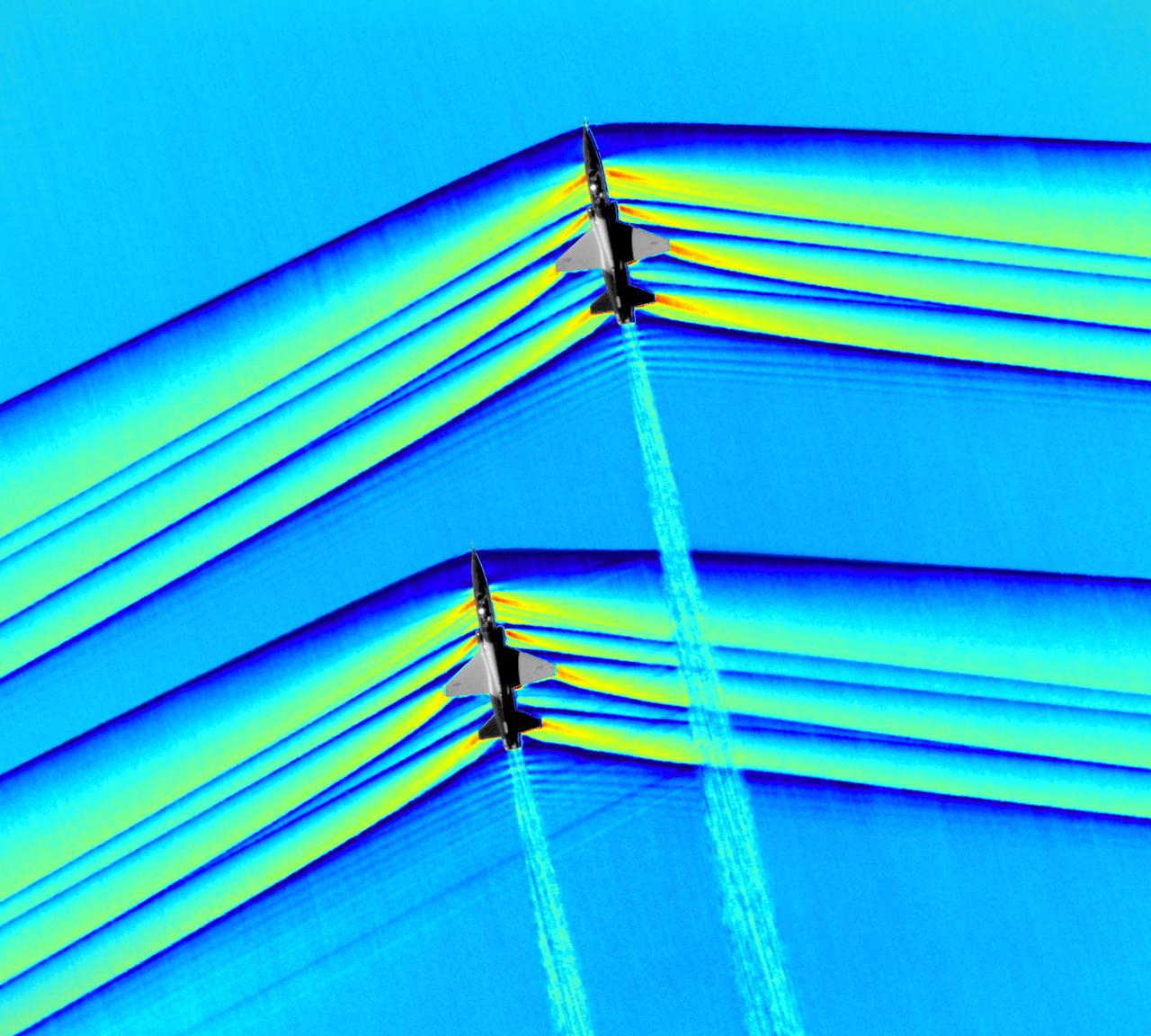
Composite image of Background Oriented Schlieren (BOS) data (contour) with a cut-out images of the T-38’s during a Mach Number 1.01 pass. This data is the first time shockwave interactions between two full scale aircraft traveling faster than the speed of sound have been imaged and shown with schlieren visualization. Original recording of the pass taken in the Black Mountain Supersonic Corridor at near Edwards AFB in December of 2018. Image acquired by JT Heineck, schlieren data processed by Neal Smith
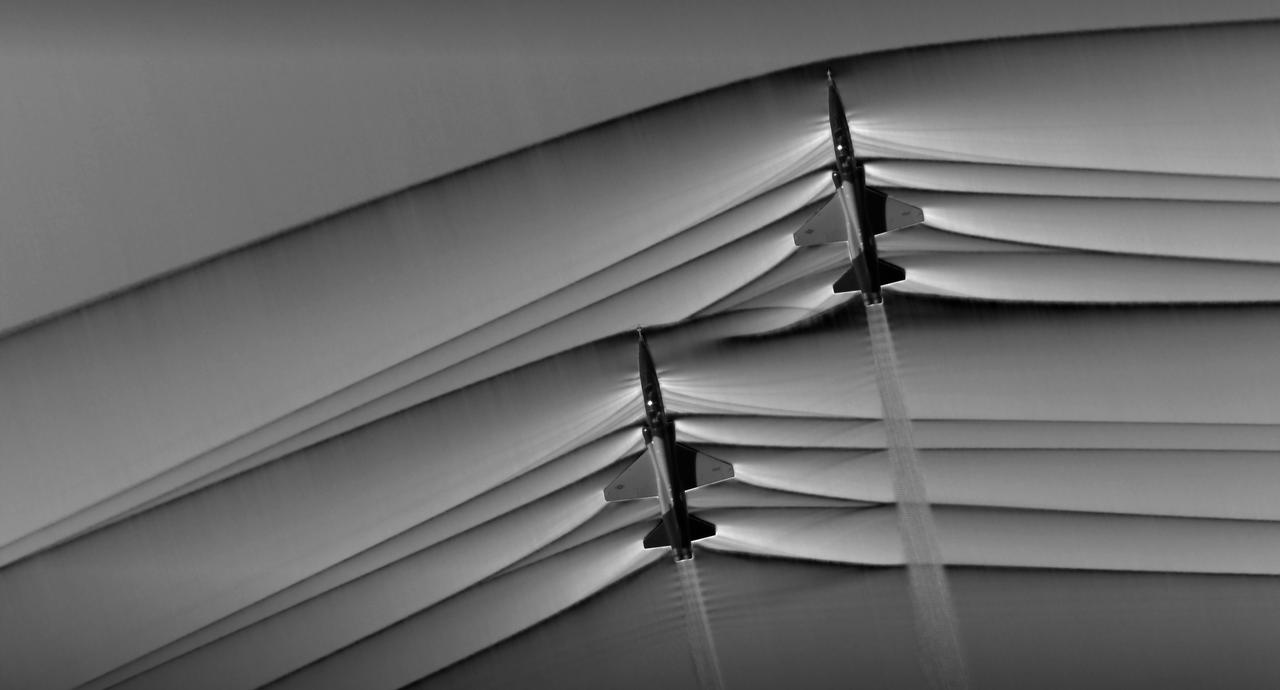
Composite image of Background Oriented Schlieren (BOS) data (contour) with a cut-out images of the T-38’s during a Mach Number 1.01 pass. This data is the first time shockwave interactions between two full scale aircraft traveling faster than the speed of sound have been imaged and shown with schlieren visualization. Original recording of the pass taken in the Black Mountain Supersonic Corridor at near Edwards AFB in December of 2018. Image acquired by JT Heineck, schlieren data processed by Neal Smith.

Composite image of Background Oriented Schlieren (BOS) data (contour) with a cut-out images of the T-38’s during a Mach Number 1.01 pass. This data is the first time shockwave interactions between two full scale aircraft traveling faster than the speed of sound have been imaged and shown with schlieren visualization. Original recording of the pass taken in the Black Mountain Supersonic Corridor at near Edwards AFB in December of 2018. Image acquired by JT Heineck, schlieren data processed by Neal Smith

jsc2023e030777 (5/30/2023) --- Artist impression of a blue jet observed from the International Space Station. ESA's Thor-Davis investigation photographs lightning from the vantage point of space. Image courtesy of Mount Visual/University of Bergen/DTU Space.
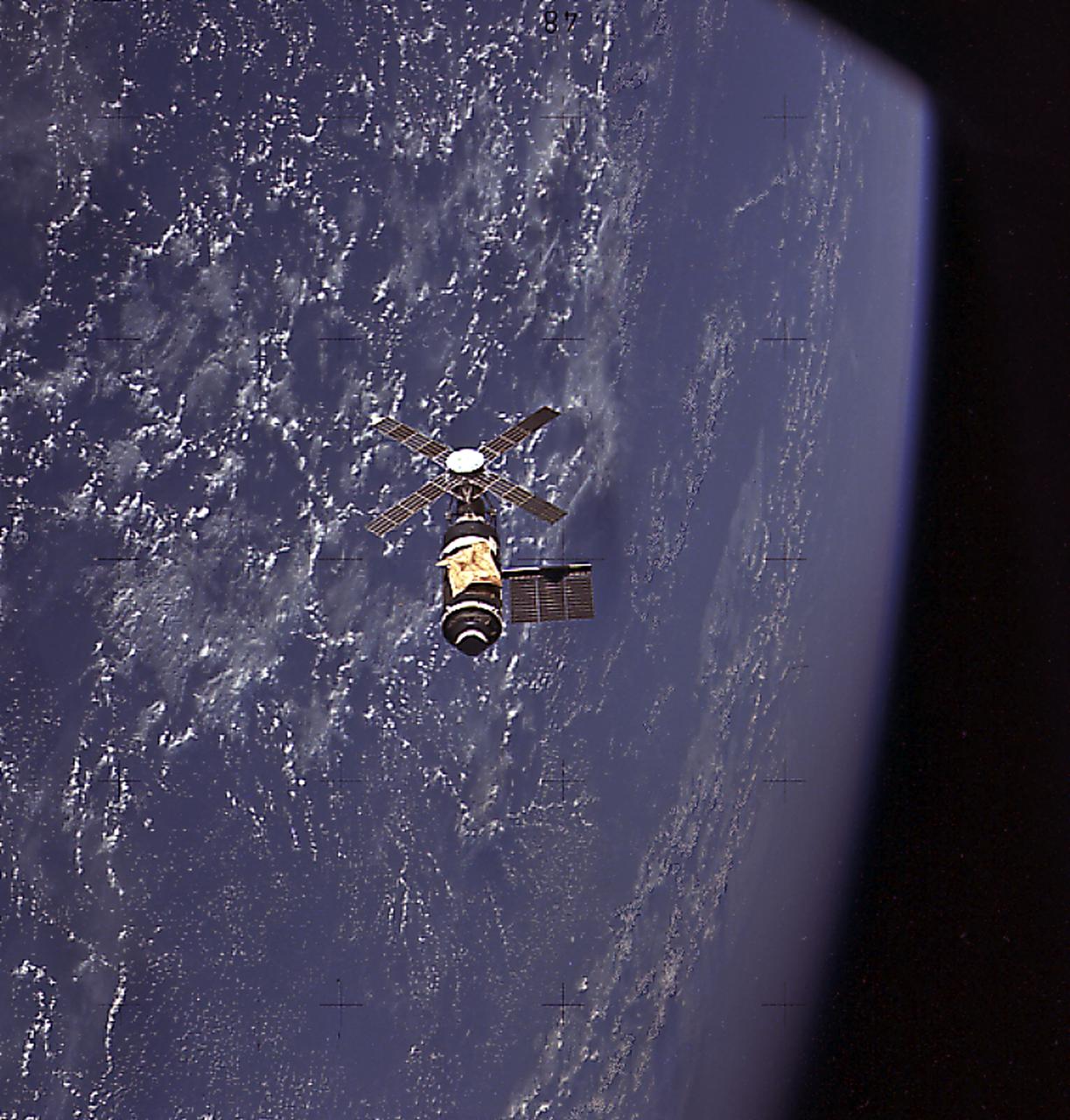
This image of Skylab in orbit was taken by the Skylab-2 crew before departing for Earth. The crew made a careful visual and photographic inspection of the orbiting laboratory. It shows the parasol sunshade, deployed by the crew, protecting the workshop. While unmarned, it operated at reduced power with many of its systems either inoperative or operating at reduced capacity.
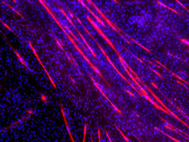
jsc2021e018129 (4/27/2021) --- Skeletal muscle myotubes form along strips of patterned scaffolds. The myotubes are labeled by antibodies directed against skeletal muscle myosin and visualized by immunofluorescence staining. The cellular nuclei are labeled in blue. Image courtesy of Palo Alto Veterans Institute for Research.
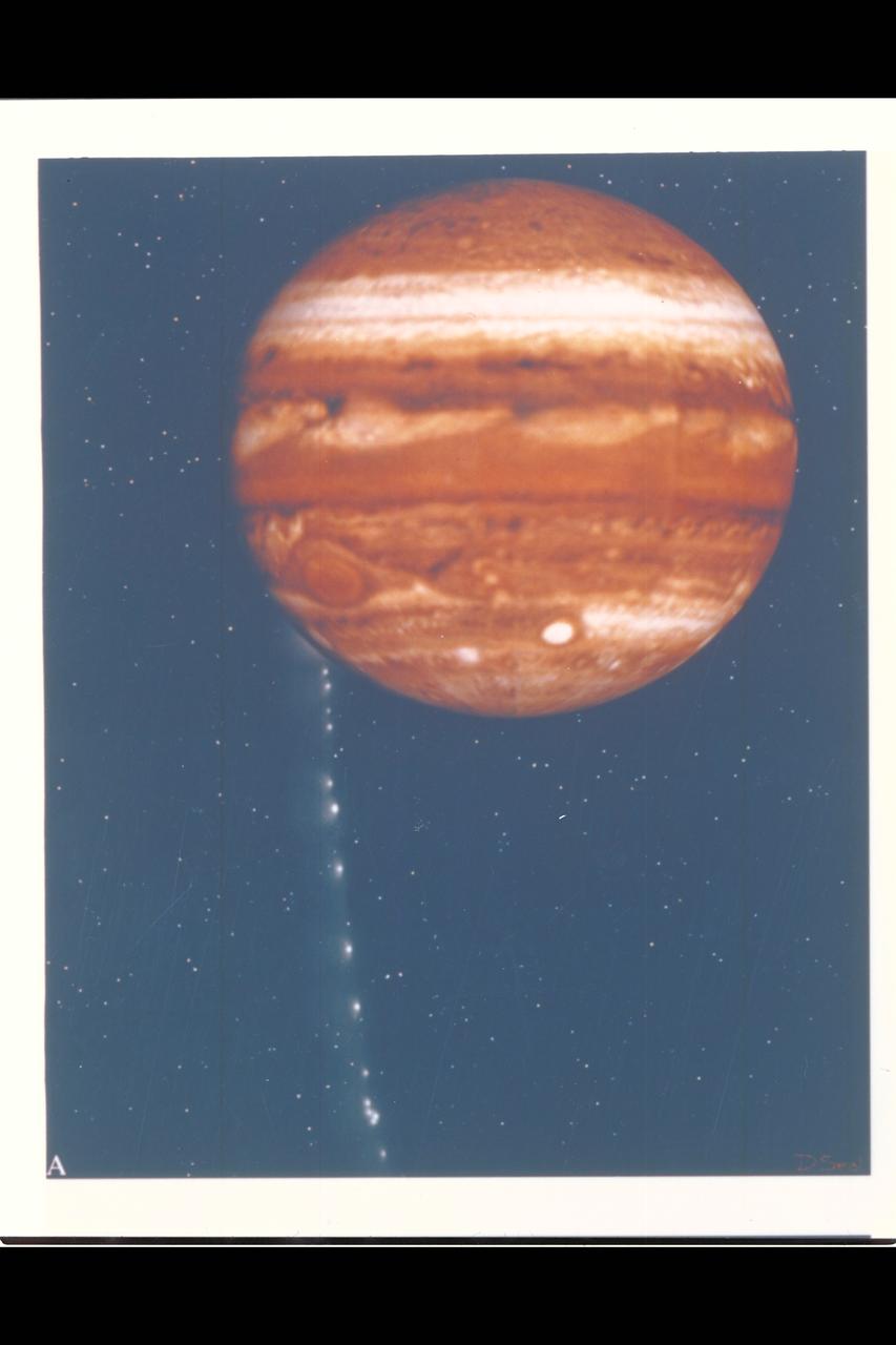
Photo Artwork composite by JPL This depiction of comet Shoemaker-Levy 9 impacting Jupiter is shown from several perspectives. IMAGE A is shown from the perspective of Earth based observers. For visual appeal, most of the large cometary fragments are shown close to one another in this image. At the time of Jupiter impact, the fragments will be separated from one another by serveral times the distances shown. This image was created by D.A. Seal of JPL's Mission Design Section using orbital computations provIded by P.W. Chodas and D.K. Yeomans of JPL's Navigation Section.
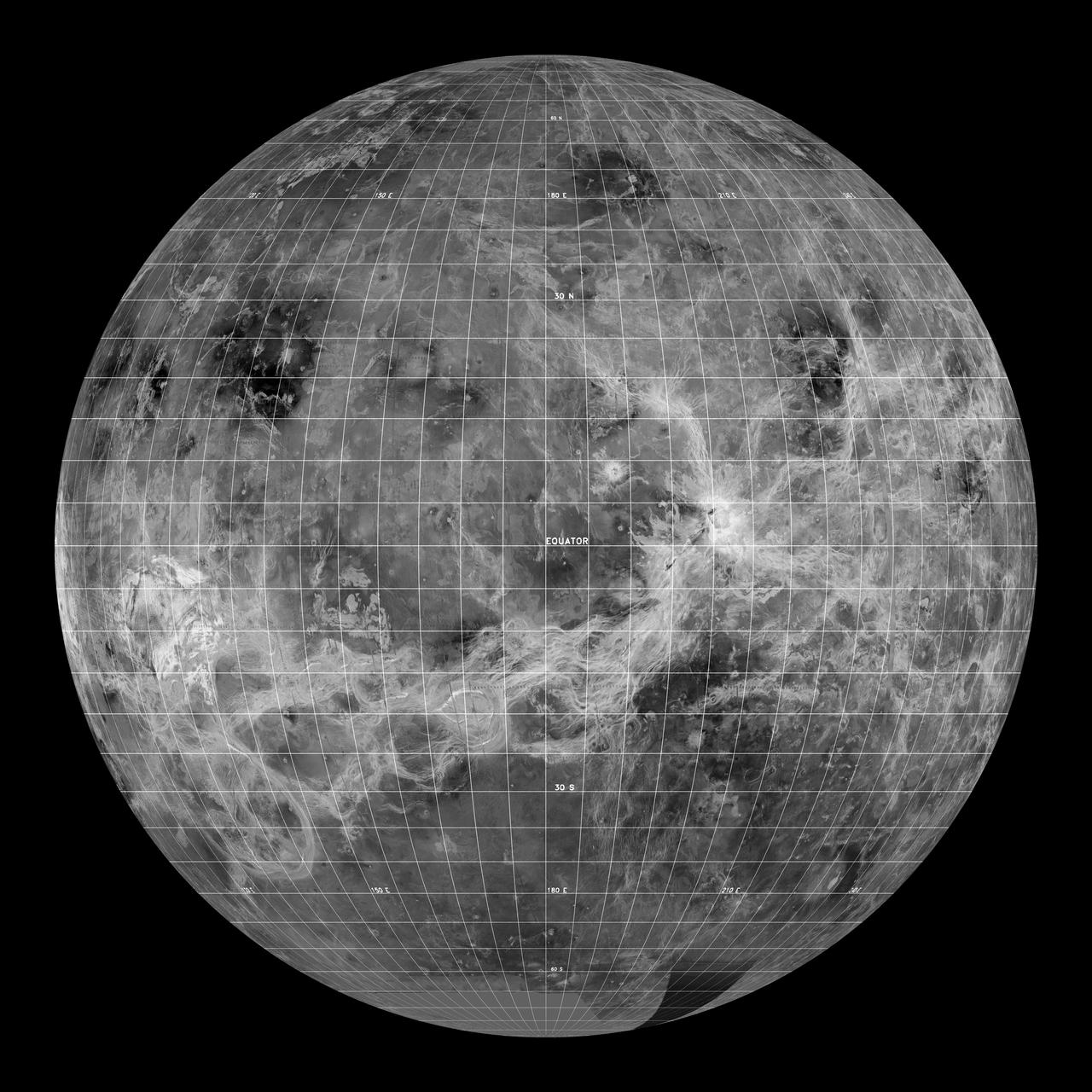
This global view of the surface of Venus is centered at 180 degrees east longitude. Magellan synthetic aperture radar mosaics from the first cycle of Magellan mapping, and a 5 degree latitude-longitude grid, are mapped onto a computer-simulated globe to create this image. Data gaps are filled with Pioneer-Venus Orbiter data, or a constant mid-range value. The image was produced by the Solar System Visualization project and the Magellan Science team at the JPL Multimission Image Processing Laboratory. http://photojournal.jpl.nasa.gov/catalog/PIA00478
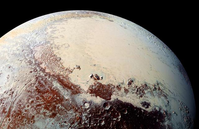
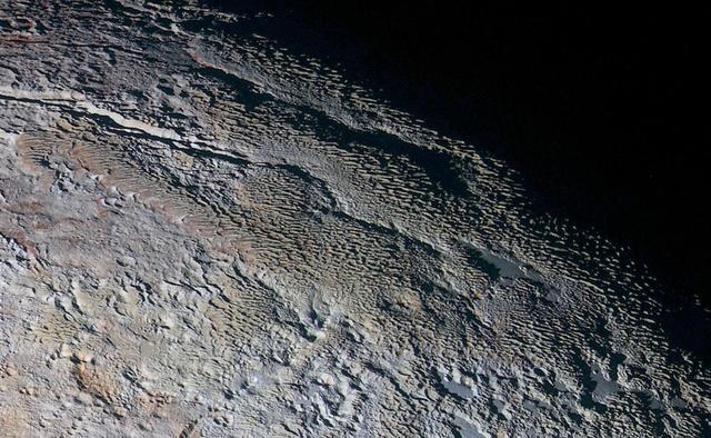
This high-resolution image captured by NASA's New Horizons spacecraft combines blue, red and infrared images taken by the Ralph/Multispectral Visual Imaging Camera (MVIC). The bright expanse is the western lobe of the "heart," informally called Sputnik Planum, which has been found to be rich in nitrogen, carbon monoxide and methane ices. http://photojournal.jpl.nasa.gov/catalog/PIA20007
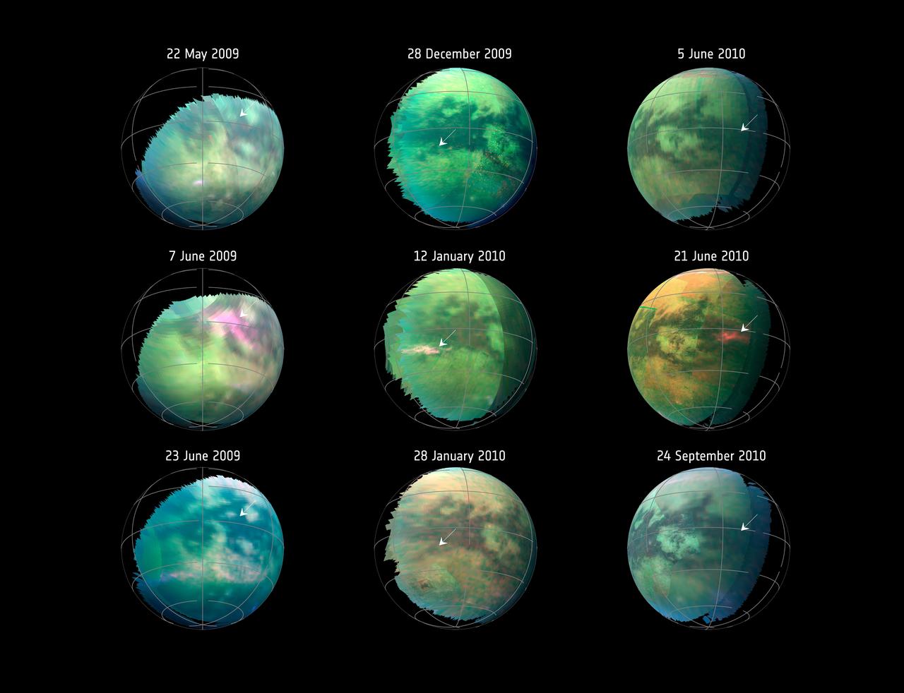
This compilation of images from nine Cassini flybys of Titan in 2009 and 2010 captures three instances when clear bright spots suddenly appeared in images taken by the spacecraft's Visual and Infrared Mapping Spectrometer. The brightenings were visible only for a short period of time -- between 11 hours to five Earth weeks -- and cannot be seen in previous or subsequent images. The Cassini spacecraft ended its mission on Sept. 15, 2017. https://photojournal.jpl.nasa.gov/catalog/PIA22484
![KENNEDY SPACE CENTER, FLA. - These towers are part of one of the world’s highest performing visual film analysis systems, developed to review and analyze previous shuttle flight data in preparation for the shuttle fleet’s return to flight. The system is being used today for another purpose. NASA has permitted its use in helping to analyze a film that shows a recent kidnapping in progress in Florida. Developed by NASA, United Space Alliance (USA) and Silicon Graphics Inc., the system allows multiple-person collaboration, highly detailed manipulation and evaluation of specific imagery. The system is housed in the Image Analysis Facility inside the Vehicle Assembly Building. [Photo taken Aug. 15, 2003, courtesy of Terry Wallace, SGI ]](https://images-assets.nasa.gov/image/KSC-04pd0152/KSC-04pd0152~medium.jpg)
KENNEDY SPACE CENTER, FLA. - These towers are part of one of the world’s highest performing visual film analysis systems, developed to review and analyze previous shuttle flight data in preparation for the shuttle fleet’s return to flight. The system is being used today for another purpose. NASA has permitted its use in helping to analyze a film that shows a recent kidnapping in progress in Florida. Developed by NASA, United Space Alliance (USA) and Silicon Graphics Inc., the system allows multiple-person collaboration, highly detailed manipulation and evaluation of specific imagery. The system is housed in the Image Analysis Facility inside the Vehicle Assembly Building. [Photo taken Aug. 15, 2003, courtesy of Terry Wallace, SGI ]
![KENNEDY SPACE CENTER, FLA. - One of the world’s highest performing visual film analysis systems, developed to review and analyze previous shuttle flight data (shown here) in preparation for the shuttle fleet’s return to flight, is being used today for another purpose. NASA has permitted its use in helping to analyze a film that shows a recent kidnapping in progress in Florida. The system, developed by NASA, United Space Alliance (USA) and Silicon Graphics Inc., allows multiple-person collaboration, highly detailed manipulation and evaluation of specific imagery. The system is housed in the Image Analysis Facility inside the Vehicle Assembly Building. [Photo taken Aug. 15, 2003, courtesy of Terry Wallace, SGI ]](https://images-assets.nasa.gov/image/KSC-04pd0150/KSC-04pd0150~medium.jpg)
KENNEDY SPACE CENTER, FLA. - One of the world’s highest performing visual film analysis systems, developed to review and analyze previous shuttle flight data (shown here) in preparation for the shuttle fleet’s return to flight, is being used today for another purpose. NASA has permitted its use in helping to analyze a film that shows a recent kidnapping in progress in Florida. The system, developed by NASA, United Space Alliance (USA) and Silicon Graphics Inc., allows multiple-person collaboration, highly detailed manipulation and evaluation of specific imagery. The system is housed in the Image Analysis Facility inside the Vehicle Assembly Building. [Photo taken Aug. 15, 2003, courtesy of Terry Wallace, SGI ]
![KENNEDY SPACE CENTER, FLA. - One of the world’s highest performing visual film analysis systems, developed to review and analyze previous shuttle flight data (shown here) in preparation for the shuttle fleet’s return to flight, is being used today for another purpose. NASA has permitted its use in helping to analyze a film that shows a recent kidnapping in progress in Florida. The system, developed by NASA, United Space Alliance (USA) and Silicon Graphics Inc., allows multiple-person collaboration, highly detailed manipulation and evaluation of specific imagery. The system is housed in the Image Analysis Facility inside the Vehicle Assembly Building. [Photo taken Aug. 15, 2003, courtesy of Terry Wallace, SGI ]](https://images-assets.nasa.gov/image/KSC-04pd0151/KSC-04pd0151~medium.jpg)
KENNEDY SPACE CENTER, FLA. - One of the world’s highest performing visual film analysis systems, developed to review and analyze previous shuttle flight data (shown here) in preparation for the shuttle fleet’s return to flight, is being used today for another purpose. NASA has permitted its use in helping to analyze a film that shows a recent kidnapping in progress in Florida. The system, developed by NASA, United Space Alliance (USA) and Silicon Graphics Inc., allows multiple-person collaboration, highly detailed manipulation and evaluation of specific imagery. The system is housed in the Image Analysis Facility inside the Vehicle Assembly Building. [Photo taken Aug. 15, 2003, courtesy of Terry Wallace, SGI ]
![KENNEDY SPACE CENTER, FLA. - One of the world’s highest performing visual film analysis systems, developed to review and analyze previous shuttle flight data (shown here) in preparation for the shuttle fleet’s return to flight, is being used today for another purpose. NASA has permitted its use in helping to analyze a film that shows a recent kidnapping in progress in Florida. The system, developed by NASA, United Space Alliance (USA) and Silicon Graphics Inc., allows multiple-person collaboration, highly detailed manipulation and evaluation of specific imagery. The system is housed in the Image Analysis Facility inside the Vehicle Assembly Building. [Photo taken Aug. 15, 2003, courtesy of Terry Wallace, SGI ]](https://images-assets.nasa.gov/image/KSC-04pd0154/KSC-04pd0154~medium.jpg)
KENNEDY SPACE CENTER, FLA. - One of the world’s highest performing visual film analysis systems, developed to review and analyze previous shuttle flight data (shown here) in preparation for the shuttle fleet’s return to flight, is being used today for another purpose. NASA has permitted its use in helping to analyze a film that shows a recent kidnapping in progress in Florida. The system, developed by NASA, United Space Alliance (USA) and Silicon Graphics Inc., allows multiple-person collaboration, highly detailed manipulation and evaluation of specific imagery. The system is housed in the Image Analysis Facility inside the Vehicle Assembly Building. [Photo taken Aug. 15, 2003, courtesy of Terry Wallace, SGI ]
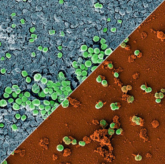
jsc2023e010179 (2/28/2023) --- This image is a composition of two scanning electron microscopic images of the bacterium Staphylococcus capitis on stainless steel versus antimicrobial copper. The image was colored to visualize the bacterial cells (green) either embedded in a biofilm matrix (blue), or covered with copper particles (red/orange). The ESA-Biofilms investigation studies bacterial biofilm formation and antimicrobial properties of different metal surfaces under spaceflight conditions in altered gravity. Both images were taken as part of the preflight experiments for ESA-Biofilms. Image courtesy of DLR, CC BY-NC-ND 3.0.
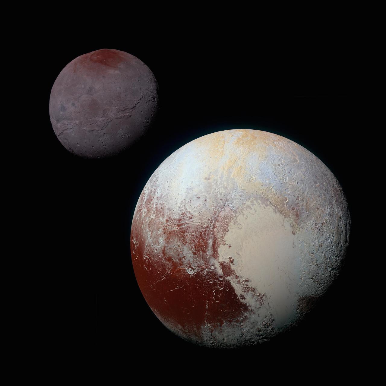
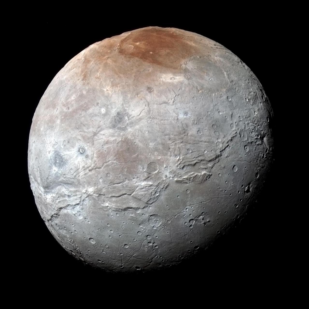
A composite of enhanced color images of Pluto (lower right) and Charon (upper left), taken by NASA's New Horizons spacecraft as it passed through the Pluto system on July 14, 2015. This image highlights the striking differences between Pluto and Charon. The color and brightness of both Pluto and Charon have been processed identically to allow direct comparison of their surface properties, and to highlight the similarity between Charon's polar red terrain and Pluto's equatorial red terrain. Pluto and Charon are shown with approximately correct relative sizes, but their true separation is not to scale. The image combines blue, red and infrared images taken by the spacecraft's Ralph/Multispectral Visual Imaging Camera (MVIC). http://photojournal.jpl.nasa.gov/catalog/PIA19966
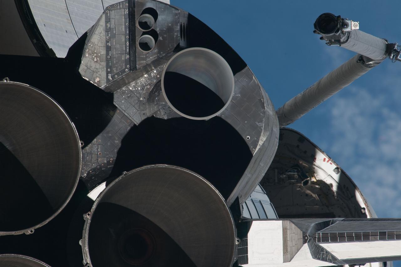
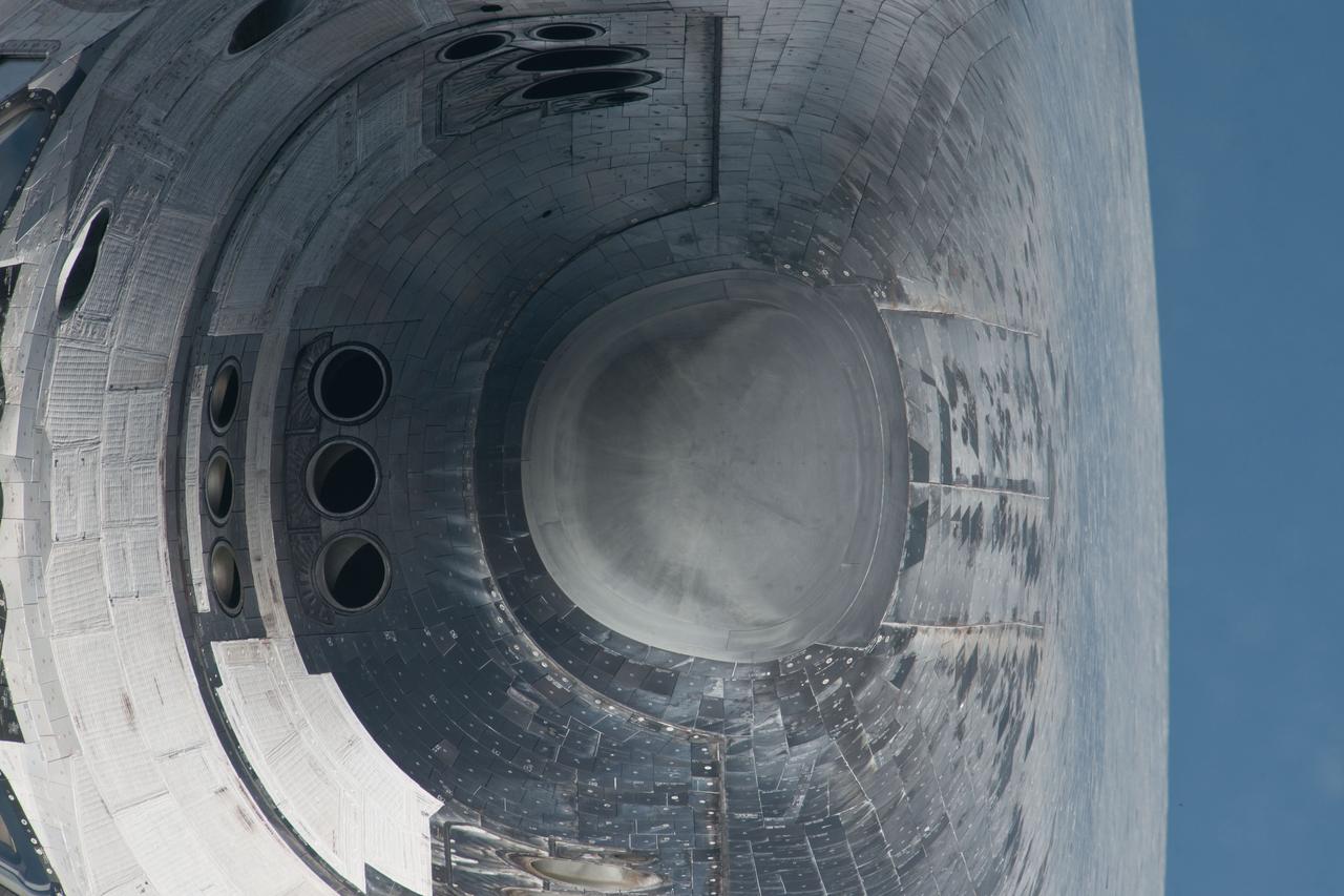
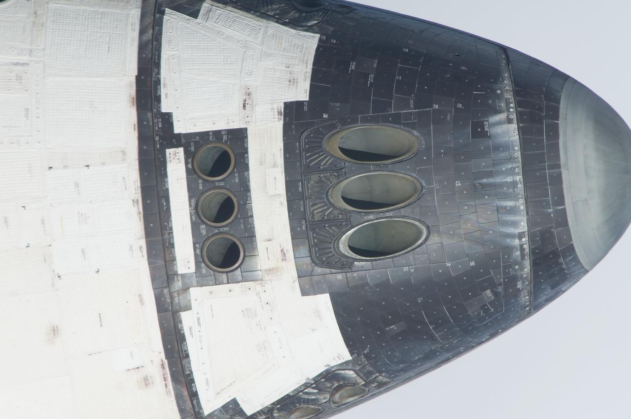
ISS028-E-015647 (10 July 2011) --- This picture of Atlantis' main and subsystem engines is one of a series of images showing various parts of the space shuttle Atlantis in Earth orbit as photographed by one of three crew members -- half the station crew -- who were equipped with still cameras for this purpose on the International Space Station as the shuttle “posed” for photos and visual surveys and performed a back-flip for the rendezvous pitch maneuver (RPM). A 1000 millimeter lens was used to capture this particular series of images.
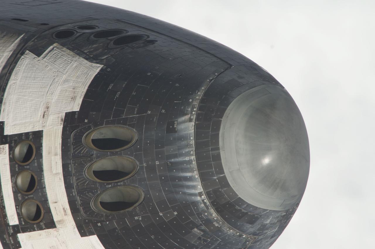
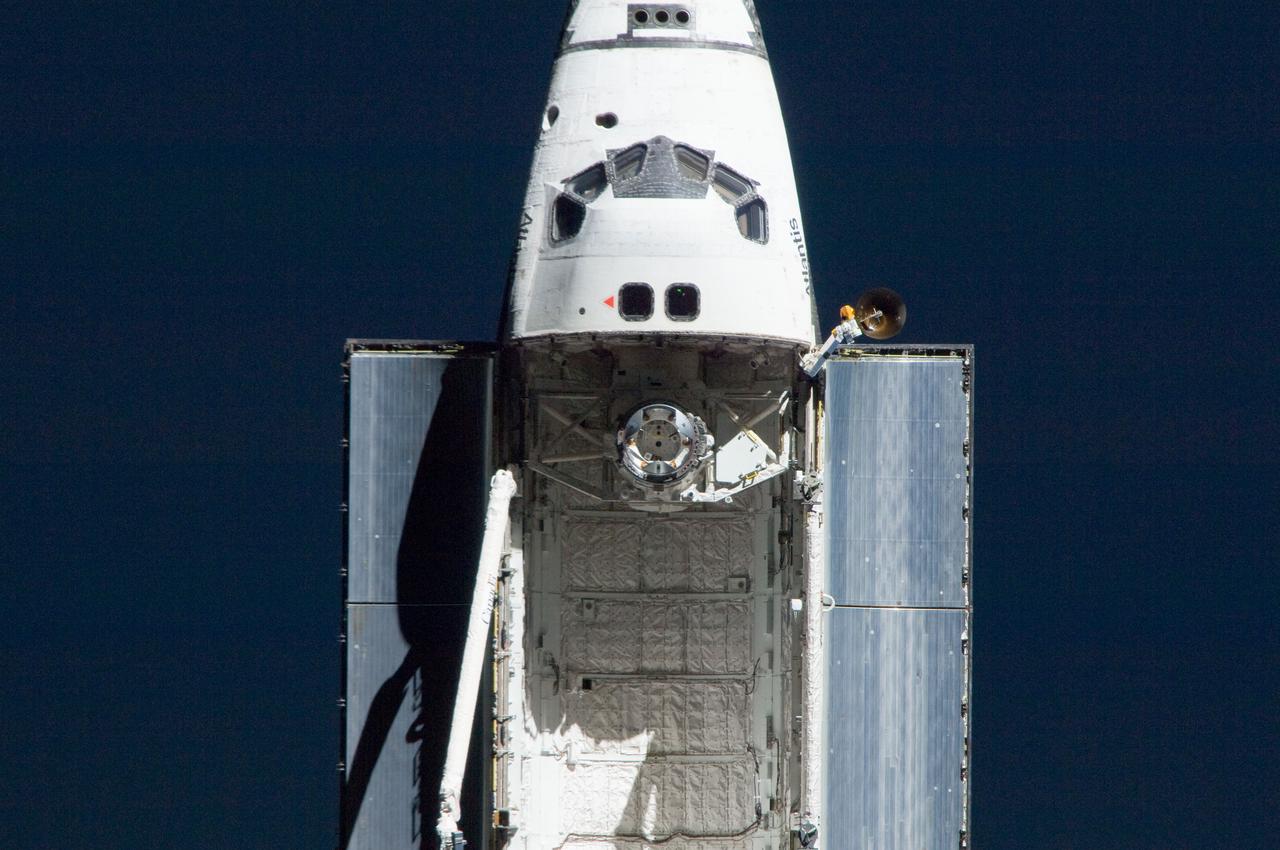
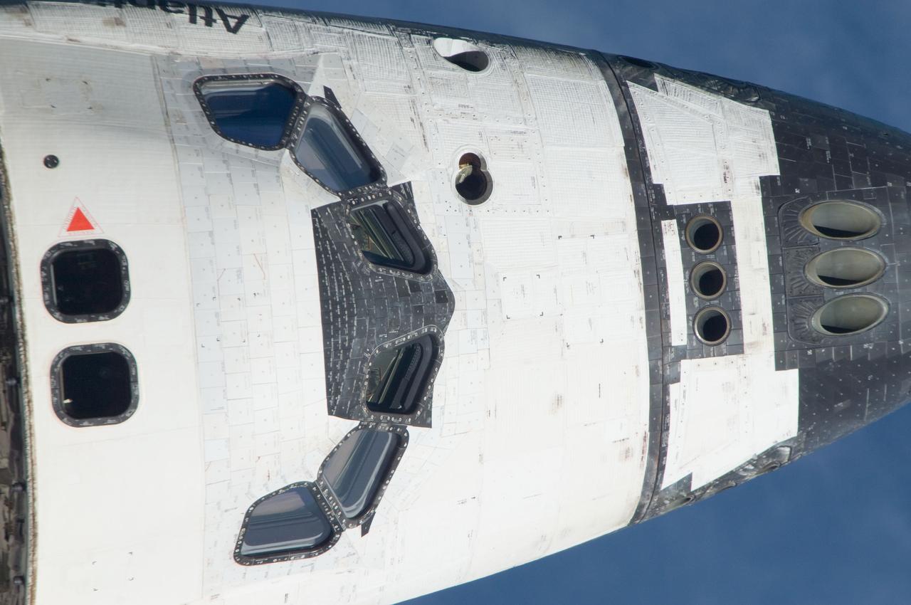
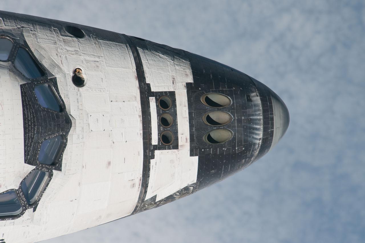
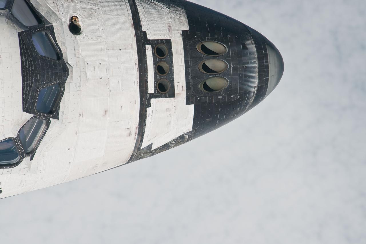
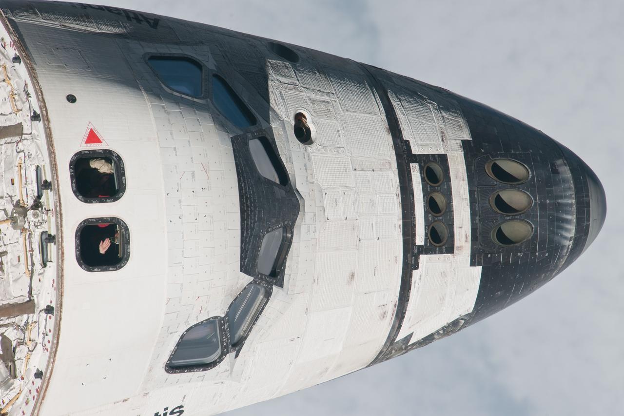
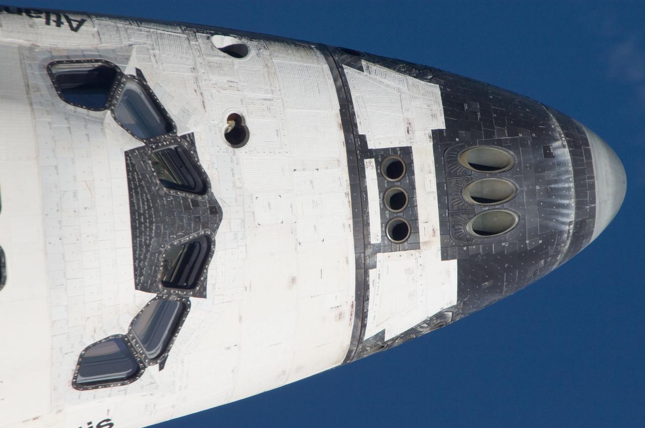
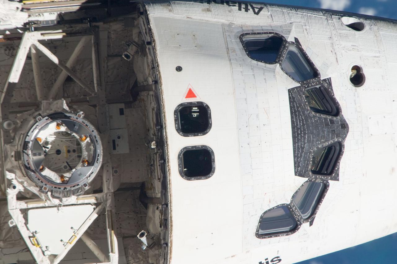
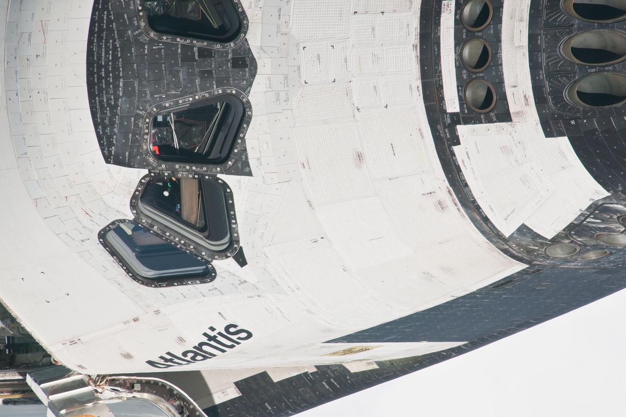
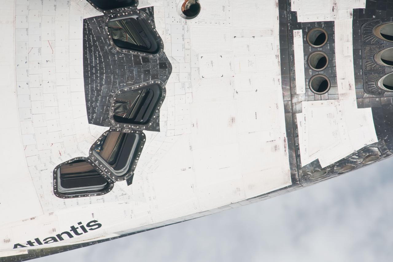
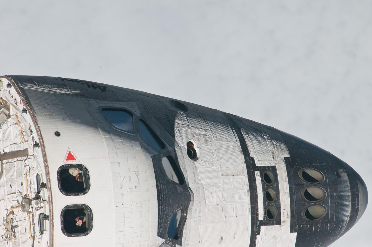
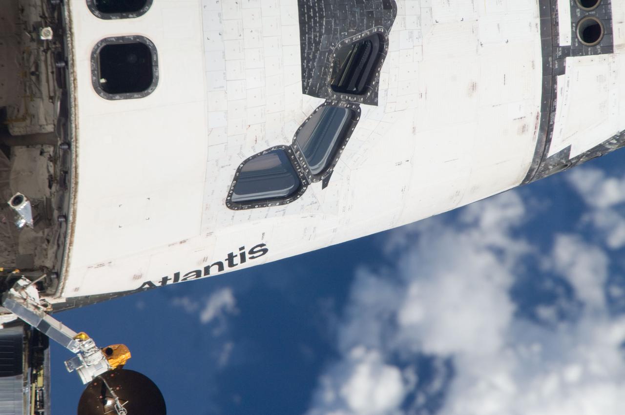
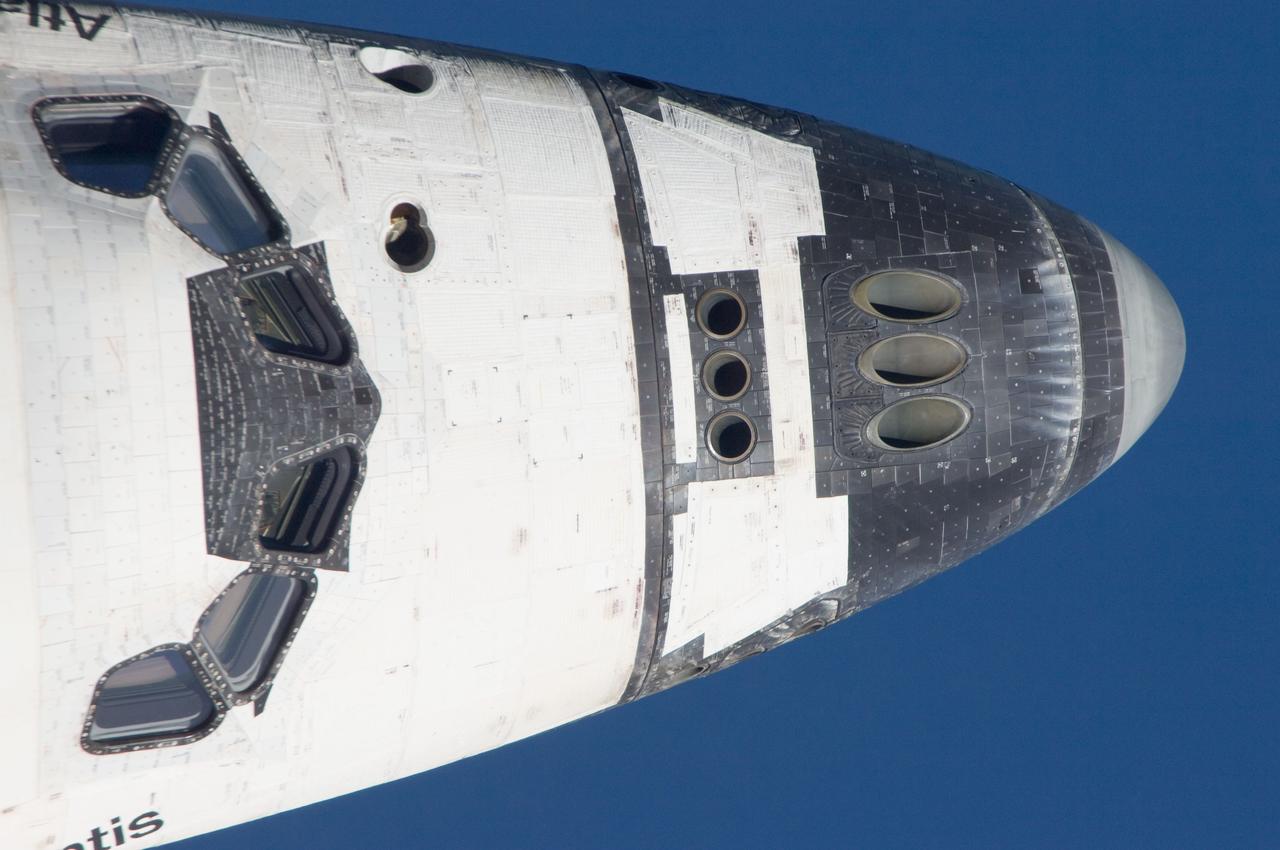
ISS028-E-015094 (10 July 2011) --- This nose view is one of a series of images showing various parts of the space shuttle Atlantis in Earth orbit as photographed by one of the six crewmembers on the International Space Station as the shuttle “posed” for photo and visual surveys and performed a back-flip for the rendezvous pitch maneuver (RPM). An 800 millimeter lens was used to capture this particular series of images.
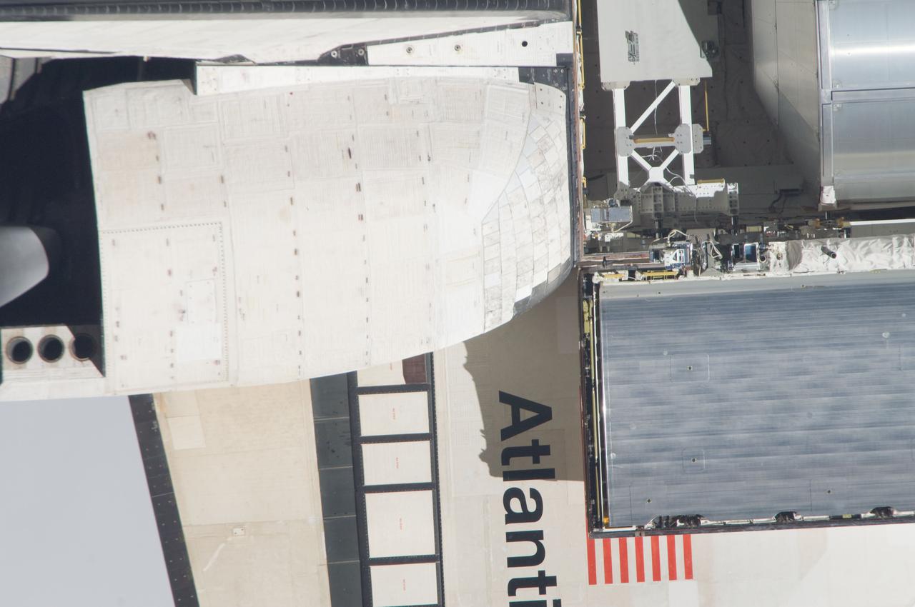
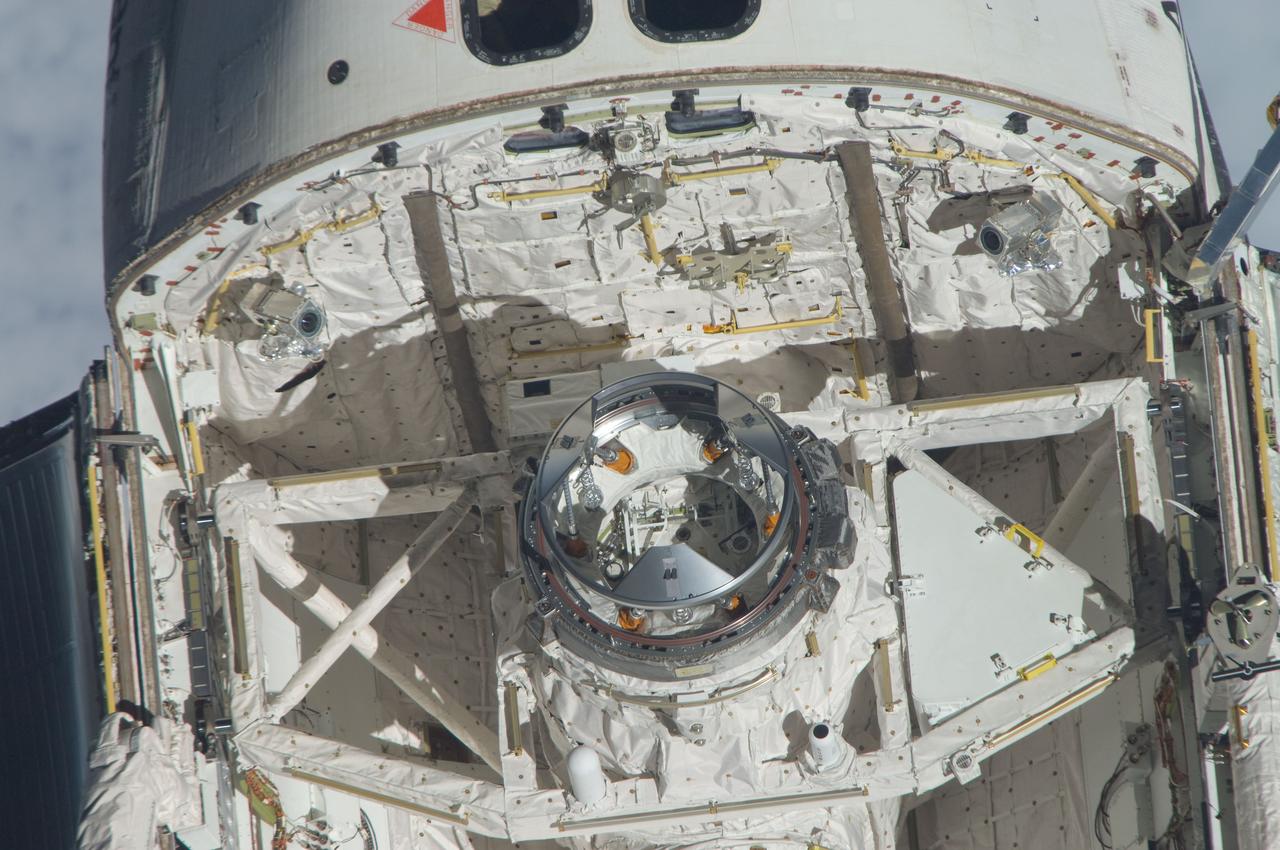
ISS028-E-015128 (10 July 2011) --- This is one of a series of images showing various parts of the space shuttle Atlantis in Earth orbit as photographed by one of the six crewmembers on the International Space Station as the shuttle “posed” for photo and visual surveys and performed a back-flip for the rendezvous pitch maneuver (RPM). An 800mm lens was used to capture this particular series of images.
ISS028-E-015086 (10 July 2011) --- This is one of a series of images showing various parts of the space shuttle Atlantis in Earth orbit as photographed by one of the six crewmembers on the International Space Station as the shuttle “posed” for photo and visual surveys and performed a back-flip for the rendezvous pitch maneuver (RPM). An 800 millimeter lens was used to capture this particular series of images.
ISS028-E-015116 (10 July 2011) --- This is one of a series of images showing various parts of the space shuttle Atlantis in Earth orbit as photographed by one of the six crewmembers on the International Space Station as the shuttle “posed” for photo and visual surveys and performed a back-flip for the rendezvous pitch maneuver (RPM). An 800 millimeter lens was used to capture this particular series of images.
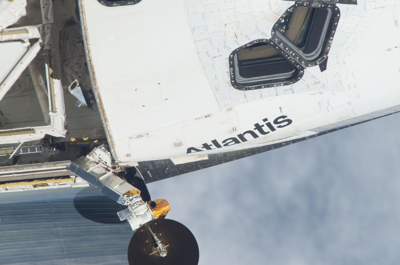
ISS028-E-015380 (10 July 2011) --- This is one of a series of images showing various parts of the space shuttle Atlantis in Earth orbit as photographed by one of the six crewmembers on the International Space Station as the shuttle “posed” for photo and visual surveys and performed a back-flip for the rendezvous pitch maneuver (RPM). An 800 millimeter lens was used to capture this particular series of images.

ISS028-E-015396 (10 July 2011) --- This is one of a series of images showing various parts of the space shuttle Atlantis in Earth orbit as photographed by one of three crewmembers – half the International Space Station crew – who were equipped with still cameras for this purpose on t station as the shuttle “posed” for photos and visual surveys and performed a back-flip for the rendezvous pitch maneuver (RPM). An 800 millimeter lens was used to capture this particular series of images.
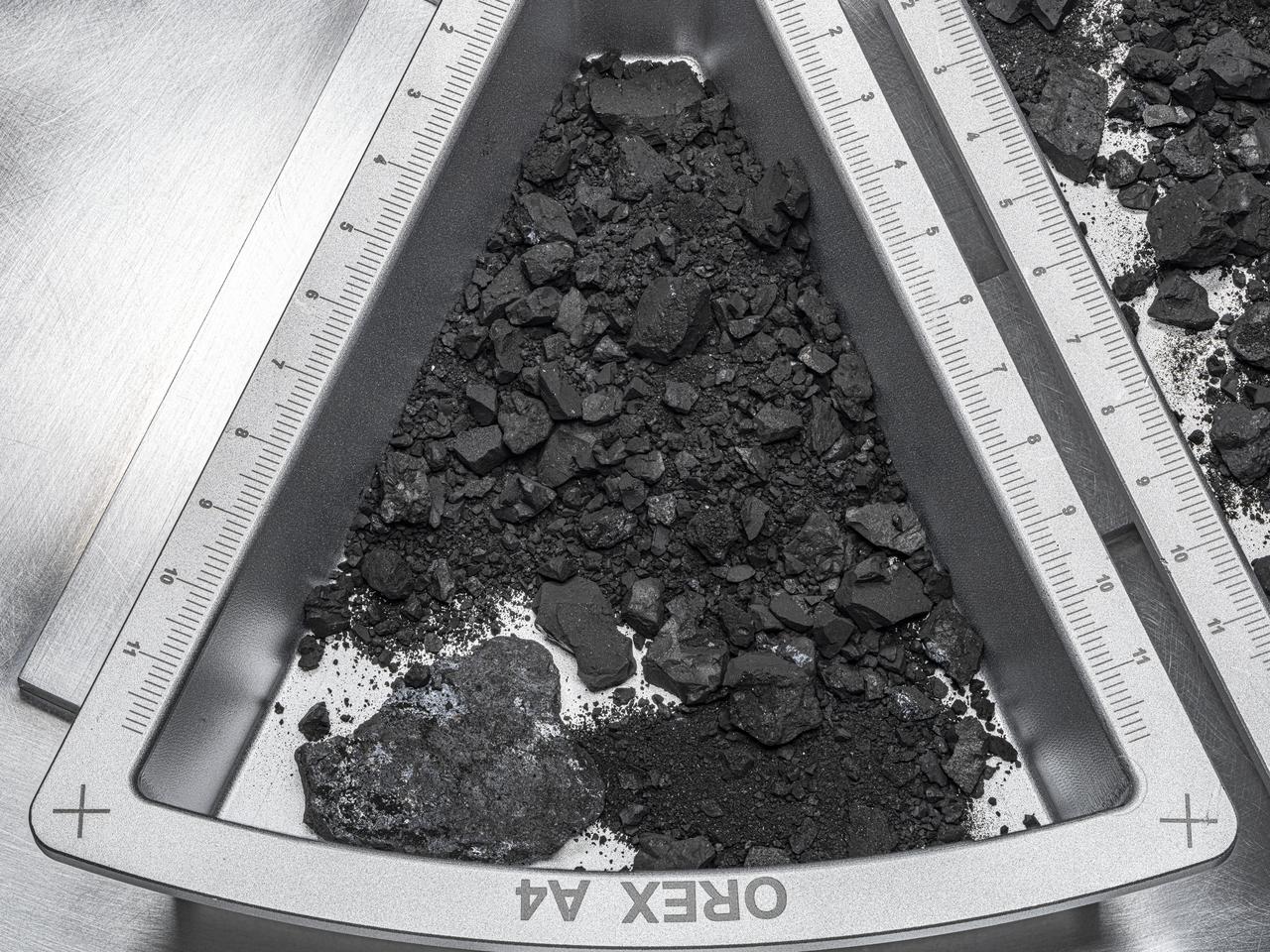
A top-down view of one of the containers holding rocks and dust from asteroid Bennu, with hardware scale marked in centimeters. Erika Blumenfeld, creative lead for the Advanced Imaging and Visualization of Astromaterials (AIVA) and Joe Aebersold, AIVA project management lead, captured this picture using manual high-resolution precision photography and a semi-automated focus stacking procedure. The result is a sample image that can be zoomed in on to show extreme detail. Credit: NASA/Erika Blumenfeld and Joseph Aebersold
ISS028-E-015098 (10 July 2011) --- This is one of a series of images showing various parts of the space shuttle Atlantis in Earth orbit as photographed by one of the six crewmembers on the International Space Station as the shuttle “posed” for photo and visual surveys and performed a back-flip for the rendezvous pitch maneuver (RPM). An 800 millimeter lens was used to capture this particular series of images.
ISS028-E-015141 (10 July 2011) --- This is one of a series of images showing various parts of the space shuttle Atlantis in Earth orbit as photographed by one of the six crewmembers on the International Space Station as the shuttle “posed” for photo and visual surveys and performed a back-flip for the rendezvous pitch maneuver (RPM). An 800 millimeter lens was used to capture this particular series of images.
ISS028-E-015600 (10 July 2011) --- This is one of a series of images showing various parts of the space shuttle Atlantis in Earth orbit as photographed by one of three crew members -- half the station crew -- who were equipped with still cameras for this purpose on the International Space Station as the shuttle “posed” for photos and visual surveys and performed a back-flip for the rendezvous pitch maneuver (RPM). A 1000 millimeter lens was used to capture this particular series of images.
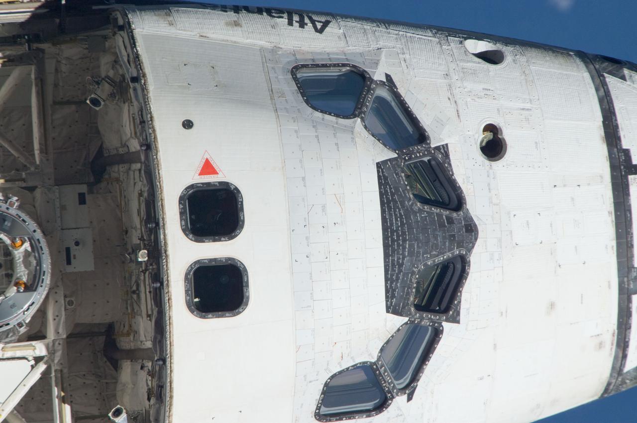
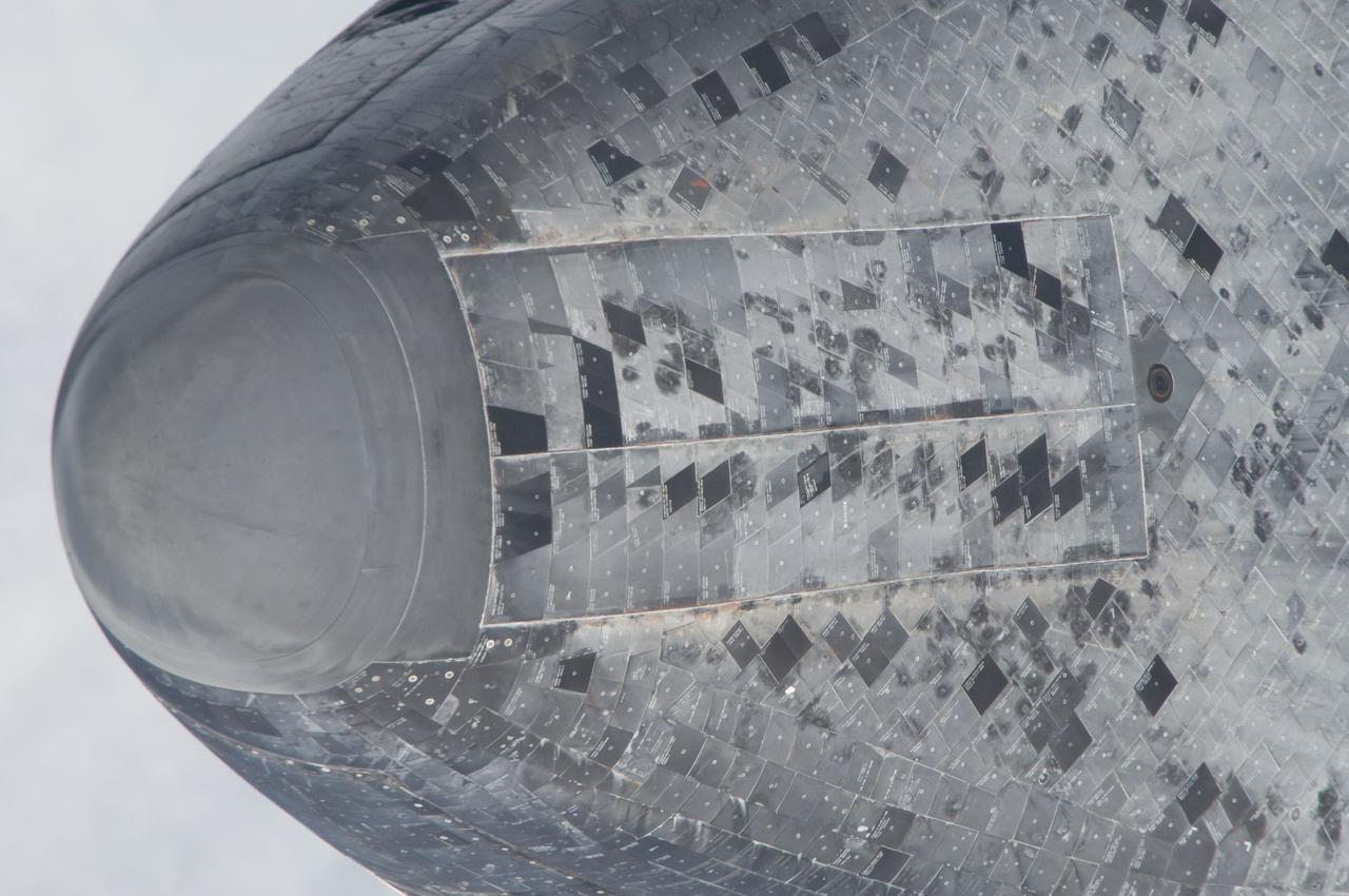
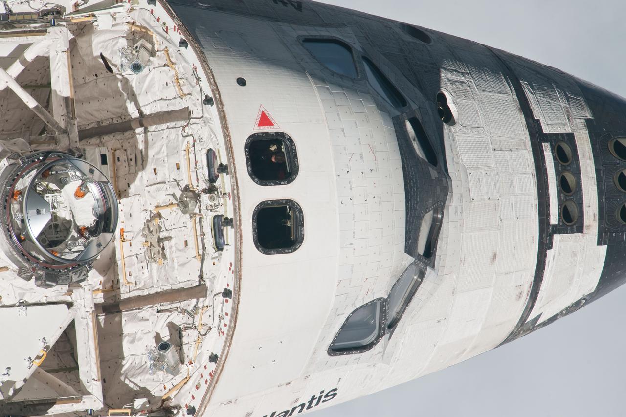
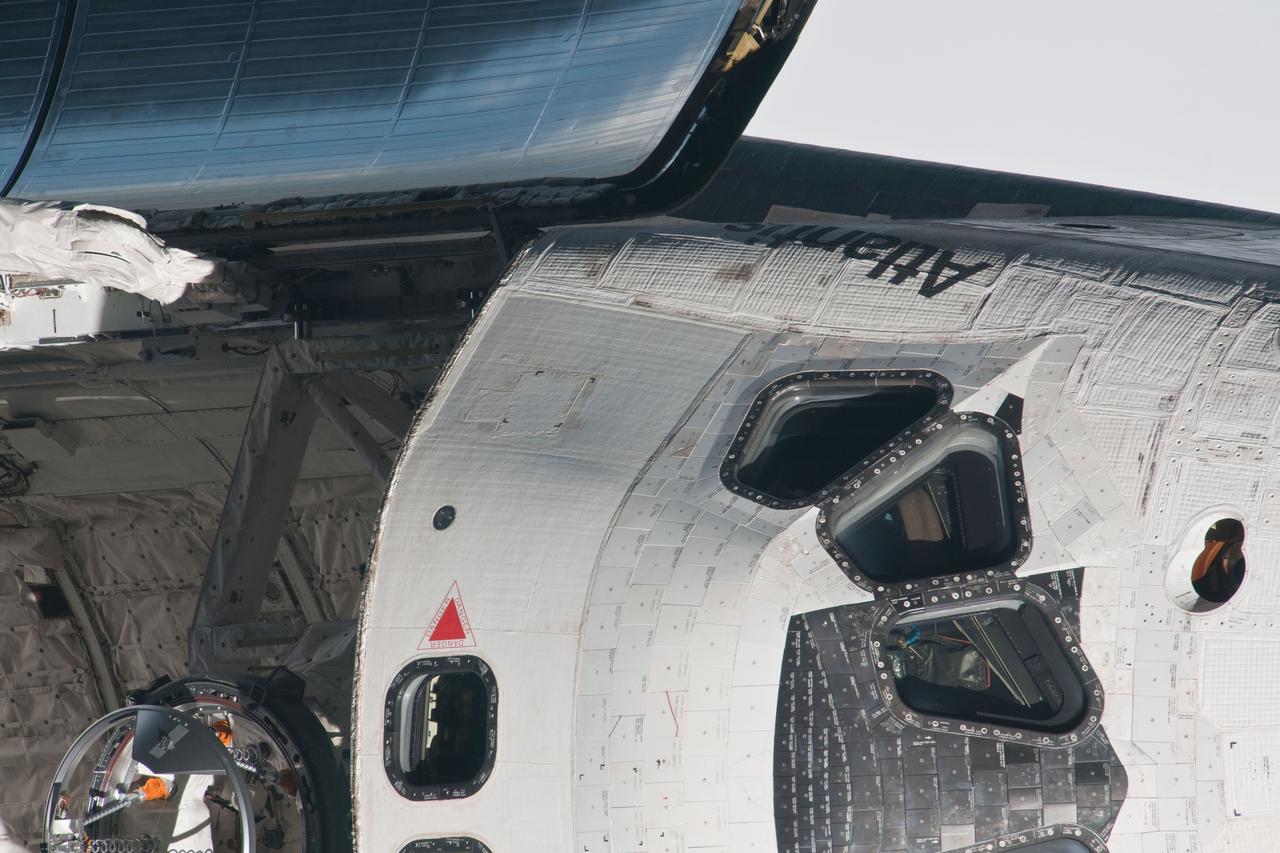
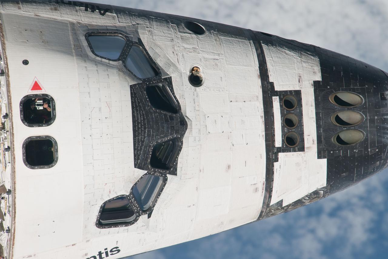
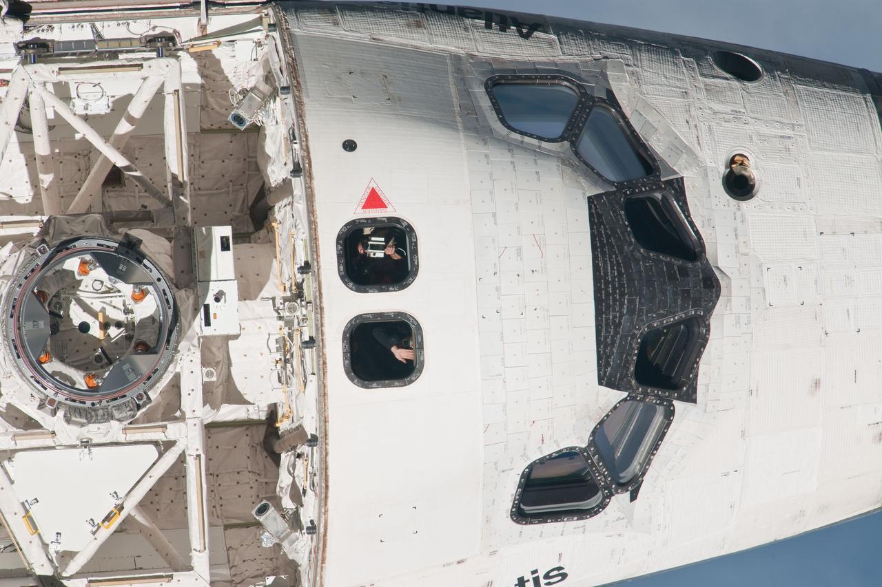
ISS028-E-015671 (10 July 2011) --- This head-on picture of Atlantis' nose and part of the underside's thermal protective system tiles is one of a series of images showing various parts of the shuttle in Earth orbit as photographed by one of three crew members -- half the station crew -- who were equipped with still cameras for this purpose on the International Space Station as the shuttle “posed” for photos and visual surveys and performed a back-flip for the rendezvous pitch maneuver (RPM). A 1000 millimeter lens was used to capture this particular series of images.
ISS028-E-015599 (10 July 2011) --- This is one of a series of images showing various parts of the space shuttle Atlantis in Earth orbit as photographed by one of three crew members -- half the station crew -- who were equipped with still cameras for this purpose on the International Space Station as the shuttle “posed” for photos and visual surveys and performed a back-flip for the rendezvous pitch maneuver (RPM). A 1000 millimeter lens was used to capture this particular series of images.
ISS028-E-015099 (10 July 2011) --- This is one of a series of images showing various parts of the space shuttle Atlantis in Earth orbit as photographed by one of the six crewmembers on the International Space Station as the shuttle “posed” for photo and visual surveys and performed a back-flip for the rendezvous pitch maneuver (RPM). An 800 millimeter lens was used to capture this particular series of images.
ISS028-E-015414 (10 July 2011) --- This is one of a series of images showing various parts of the space shuttle Atlantis in Earth orbit as photographed by one of the six crewmembers on the International Space Station as the shuttle “posed” for photo and visual surveys and performed a back-flip for the rendezvous pitch maneuver (RPM). An 800 millimeter lens was used to capture this particular series of images.
ISS028-E-015597 (10 July 2011) --- This is one of a series of images showing various parts of the space shuttle Atlantis in Earth orbit as photographed by one of three crew members -- half the station crew -- who were equipped with still cameras for this purpose on the International Space Station as the shuttle “posed” for photos and visual surveys and performed a back-flip for the rendezvous pitch maneuver (RPM). A 1000 millimeter lens was used to capture this particular series of images.
ISS028-E-015146 (10 July 2011) --- This is one of a series of images showing various parts of the space shuttle Atlantis in Earth orbit as photographed by one of the six crewmembers on the International Space Station as the shuttle “posed” for photo and visual surveys and performed a back-flip for the rendezvous pitch maneuver (RPM). An 800 millimeter lens was used to capture this particular series of images.
ISS028-E-015178 (10 July 2011) --- This is one of a series of images showing various parts of the space shuttle Atlantis in Earth orbit as photographed by one of the six crewmembers on the International Space Station as the shuttle “posed” for photo and visual surveys and performed a back-flip for the rendezvous pitch maneuver (RPM). An 800 millimeter lens was used to capture this particular series of images.
ISS028-E-015148 (10 July 2011) --- This is one of a series of images showing various parts of the space shuttle Atlantis in Earth orbit as photographed by one of the six crewmembers on the International Space Station as the shuttle “posed” for photo and visual surveys and performed a back-flip for the rendezvous pitch maneuver (RPM). An 800 millimeter lens was used to capture this particular series of images.
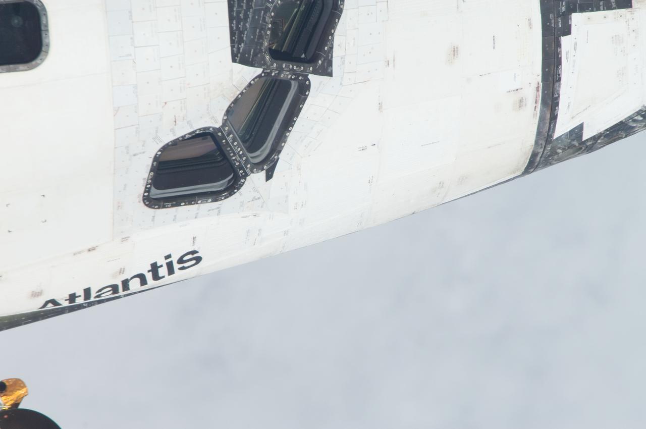
ISS028-E-015668 (10 July 2011) --- This is one of a series of images showing various parts of the space shuttle Atlantis in Earth orbit as photographed by one of three crew members -- half the station crew -- who were equipped with still cameras for this purpose on the International Space Station as the shuttle “posed” for photos and visual surveys and performed a back-flip for the rendezvous pitch maneuver (RPM). A 1000 millimeter lens was used to capture this particular series of images.
ISS028-E-015129 (10 July 2011) --- This is one of a series of images showing various parts of the space shuttle Atlantis in Earth orbit as photographed by one of the six crewmembers on the International Space Station as the shuttle “posed” for photo and visual surveys and performed a back-flip for the rendezvous pitch maneuver (RPM). An 800 millimeter lens was used to capture this particular series of images.
ISS028-E-015593 (10 July 2011) --- This is one of a series of images showing various parts of the space shuttle Atlantis in Earth orbit as photographed by one of three crew members -- half the station crew -- who were equipped with still cameras for this purpose on the International Space Station as the shuttle “posed” for photos and visual surveys and performed a back-flip for the rendezvous pitch maneuver (RPM). A 1000 millimeter lens was used to capture this particular series of images.
ISS028-E-015117 (10 July 2011) --- This is one of a series of images showing various parts of the space shuttle Atlantis in Earth orbit as photographed by one of the six crewmembers on the International Space Station as the shuttle “posed” for photo and visual surveys and performed a back-flip for the rendezvous pitch maneuver (RPM). An 800 millimeter lens was used to capture this particular series of images.
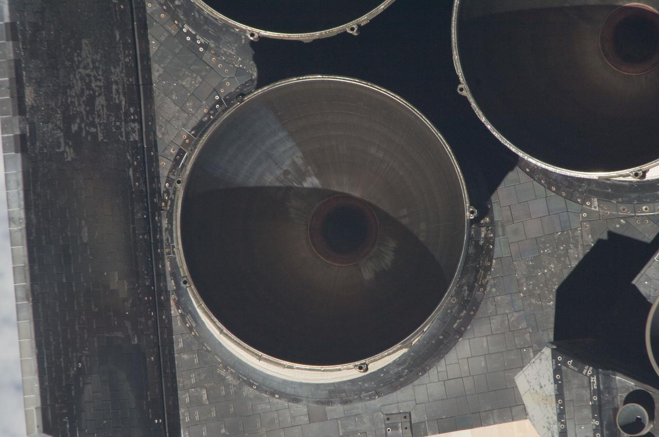
ISS028-E-015328 (10 July 2011) --- Parts of Atlantis' set of main engines are visible in one of a series of images showing various parts of the space shuttle in Earth orbit as photographed by one of the six crewmembers on the International Space Station as the shuttle “posed” for photo and visual surveys and performed a back-flip for the rendezvous pitch maneuver (RPM). An 800 millimeter lens was used to capture this particular series of images.
ISS028-E-015659 (10 July 2011) --- This is one of a series of images showing various parts of the space shuttle Atlantis in Earth orbit as photographed by one of three crew members -- half the station crew -- who were equipped with still cameras for this purpose on the International Space Station as the shuttle “posed” for photos and visual surveys and performed a back-flip for the rendezvous pitch maneuver (RPM). A 1000 millimeter lens was used to capture this particular series of images.
ISS028-E-015662 (10 July 2011) --- This is one of a series of images showing various parts of the space shuttle Atlantis in Earth orbit as photographed by one of three crew members -- half the station crew -- who were equipped with still cameras for this purpose on the International Space Station as the shuttle “posed” for photos and visual surveys and performed a back-flip for the rendezvous pitch maneuver (RPM). A 1000 millimeter lens was used to capture this particular series of images.
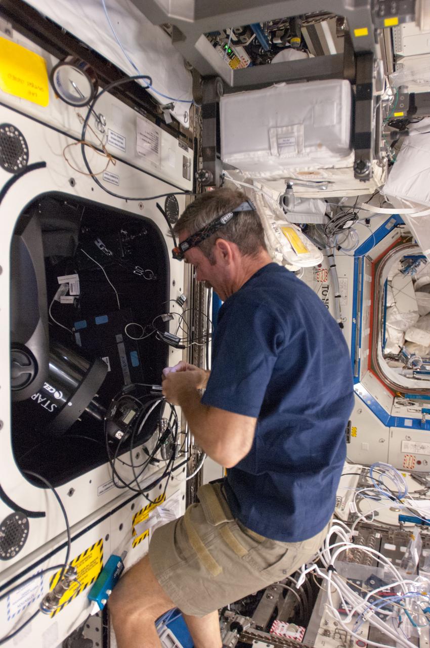
ISS034-E-029975 (15 Jan. 2013) --- Canadian Space Agency astronaut Chris Hadfield, Expedition 34 flight engineer, sets up the ISS SERVIR Environmental Research and Visualization System (ISERV) in the Destiny laboratory of the International Space Station. ISERV is a fully automated image data acquisition system that flies aboard the space station and deploys in the Window Observational Research Facility (WORF) rack within Destiny. The study is expected to provide useful images for use in disaster monitoring and assessment and environmental decision making.
ISS028-E-015596 (10 July 2011) --- This is one of a series of images showing various parts of the space shuttle Atlantis in Earth orbit as photographed by one of three crew members -- half the station crew -- who were equipped with still cameras for this purpose on the International Space Station as the shuttle “posed” for photos and visual surveys and performed a back-flip for the rendezvous pitch maneuver (RPM). A 1000 millimeter lens was used to capture this particular series of images.
ISS028-E-015652 (10 July 2011) --- This is one of a series of images showing various parts of the space shuttle Atlantis in Earth orbit as photographed by one of three crew members -- half the station crew -- who were equipped with still cameras for this purpose on the International Space Station as the shuttle “posed” for photos and visual surveys and performed a back-flip for the rendezvous pitch maneuver (RPM). A 1000 millimeter lens was used to capture this particular series of images.
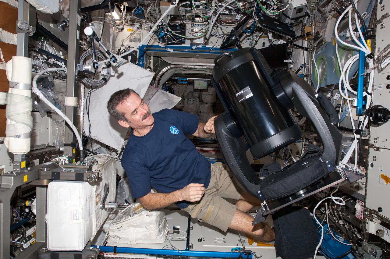
ISS034-E-029961 (15 Jan. 2013) --- Canadian Space Agency astronaut Chris Hadfield, Expedition 34 flight engineer, prepares to set up the ISS SERVIR Environmental Research and Visualization System (ISERV) in the Destiny laboratory of the International Space Station. ISERV is a fully automated image data acquisition system that flies aboard the space station and deploys in the Window Observational Research Facility (WORF) rack within Destiny. The study is expected to provide useful images for use in disaster monitoring and assessment and environmental decision making.
ISS028-E-015132 (10 July 2011) --- This is one of a series of images showing various parts of the space shuttle Atlantis in Earth orbit as photographed by one of the six crewmembers on the International Space Station as the shuttle “posed” for photo and visual surveys and performed a back-flip for the rendezvous pitch maneuver (RPM). An 800 millimeter lens was used to capture this particular series of images.
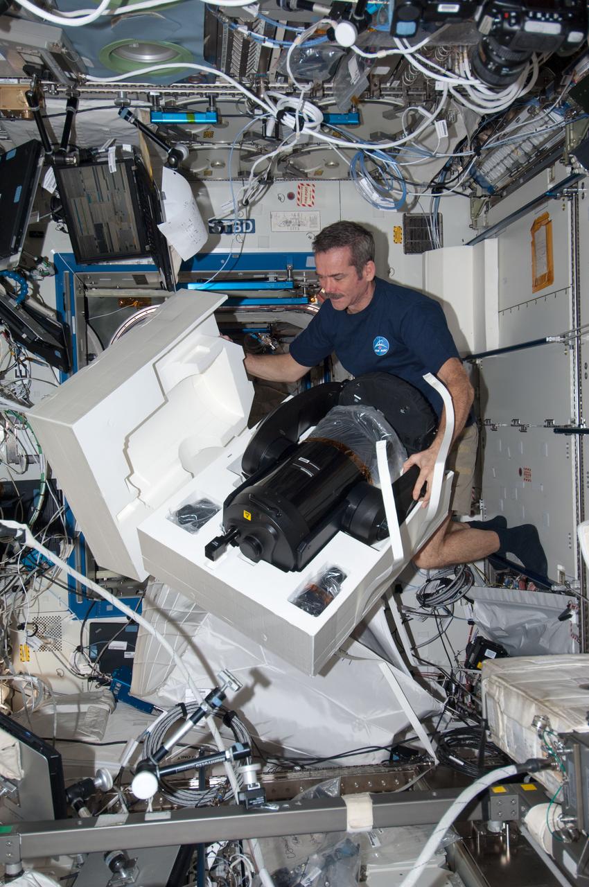
ISS034-E-029914 (15 Jan. 2013) --- Canadian Space Agency astronaut Chris Hadfield, Expedition 34 flight engineer, prepares to set up the ISS SERVIR Environmental Research and Visualization System (ISERV) in the Destiny laboratory of the International Space Station. ISERV is a fully automated image data acquisition system that flies aboard the space station and deploys in the Window Observational Research Facility (WORF) rack within Destiny. The study is expected to provide useful images for use in disaster monitoring and assessment and environmental decision making.
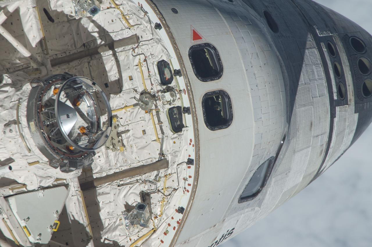
ISS028-E-015398 (10 July 2011) --- This is one of a series of images showing various parts of the space shuttle Atlantis in Earth orbit as photographed by one of three crewmembers – half the International Space Station crew – who were equipped with still cameras for this purpose on the station as the shuttle “posed” for photos and visual surveys and performed a back-flip for the rendezvous pitch maneuver (RPM). An 800 millimeter lens was used to capture this particular series of images.
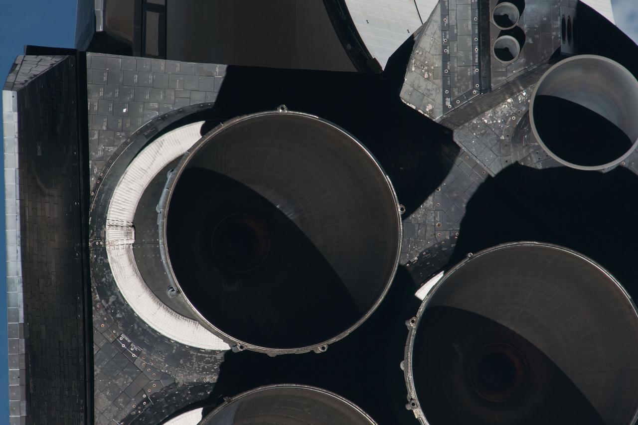
ISS028-E-015588 (10 July 2011) --- This picture of Atlantis' main and subsystem engines is one of a series of images showing various parts of the space shuttle Atlantis in Earth orbit as photographed by one of three crew members -- half the station crew -- who were equipped with still cameras for this purpose on the International Space Station as the shuttle “posed” for photos and visual surveys and performed a back-flip for the rendezvous pitch maneuver (RPM). A 1000 millimeter lens was used to capture this particular series of images.
ISS028-E-015135 (10 July 2011) --- This is one of a series of images showing various parts of the space shuttle Atlantis in Earth orbit as photographed by one of the six crewmembers on the International Space Station as the shuttle “posed” for photo and visual surveys and performed a back-flip for the rendezvous pitch maneuver (RPM). An 800 millimeter lens was used to capture this particular series of images.
ISS028-E-015155 (10 July 2011) --- This is one of a series of images showing various parts of the space shuttle Atlantis in Earth orbit as photographed by one of the six crewmembers on the International Space Station as the shuttle “posed” for photo and visual surveys and performed a back-flip for the rendezvous pitch maneuver (RPM). An 800 millimeter lens was used to capture this particular series of images.
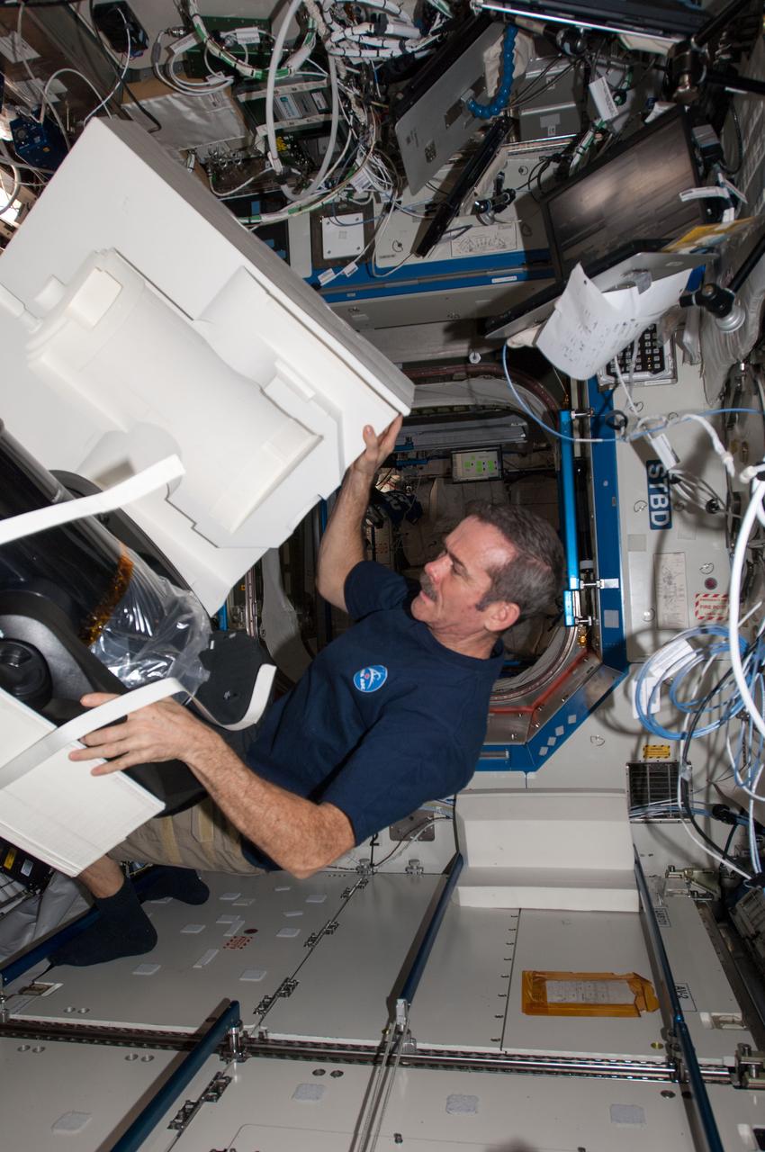
ISS034-E-029954 (15 Jan. 2013) --- Canadian Space Agency astronaut Chris Hadfield, Expedition 34 flight engineer, prepares to set up the ISS SERVIR Environmental Research and Visualization System (ISERV) in the Destiny laboratory of the International Space Station. ISERV is a fully automated image data acquisition system that flies aboard the space station and deploys in the Window Observational Research Facility (WORF) rack within Destiny. The study is expected to provide useful images for use in disaster monitoring and assessment and environmental decision making.
ISS028-E-015601 (10 July 2011) --- This is one of a series of images showing various parts of the space shuttle Atlantis in Earth orbit as photographed by one of three crew members -- half the station crew -- who were equipped with still cameras for this purpose on the International Space Station as the shuttle “posed” for photos and visual surveys and performed a back-flip for the rendezvous pitch maneuver (RPM). A 1000 millimeter lens was used to capture this particular series of images.
ISS028-E-015147 (10 July 2011) --- This is one of a series of images showing various parts of the space shuttle Atlantis in Earth orbit as photographed by one of the six crewmembers on the International Space Station as the shuttle “posed” for photo and visual surveys and performed a back-flip for the rendezvous pitch maneuver (RPM). An 800 millimeter lens was used to capture this particular series of images.
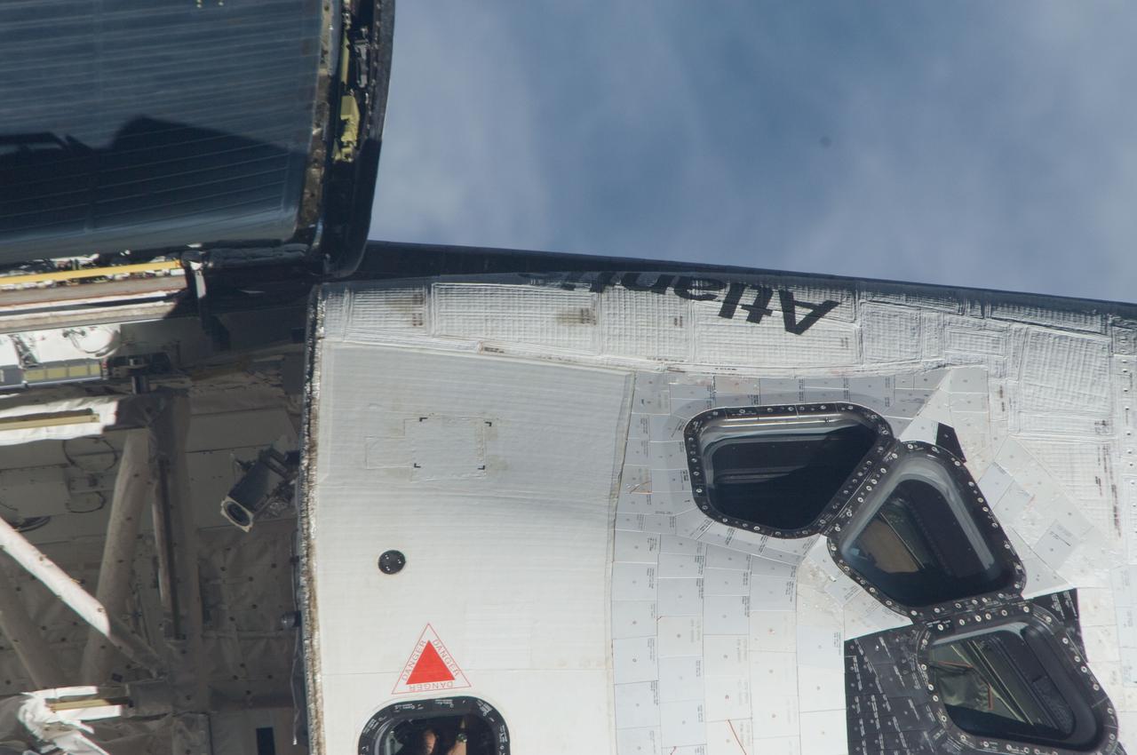
ISS028-E-015127 (10 July 2011) ---This is one of a series of images showing various parts of the space shuttle Atlantis in Earth orbit as photographed by one of the six crewmembers on the International Space Station as the shuttle “posed” for photo and visual surveys and performed a back-flip for the rendezvous pitch maneuver (RPM). An 800 millimeter lens was used to capture this particular series of images.
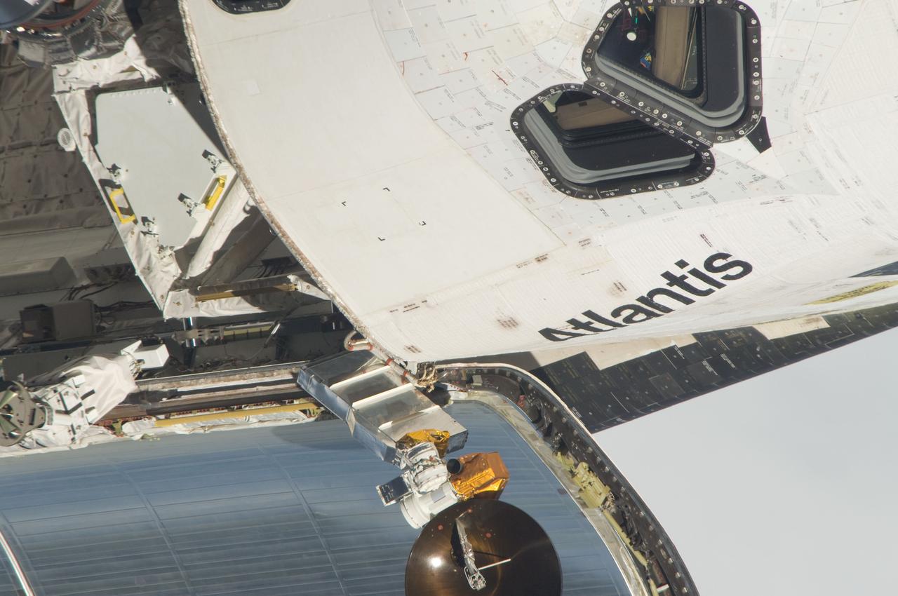
ISS028-E-015081 (10 July 2011) --- This is one of a series of images showing various parts of the space shuttle Atlantis in Earth orbit as photographed by one of the six crewmembers on the International Space Station as the shuttle “posed” for photo and visual surveys and performed a back-flip for the rendezvous pitch maneuver (RPM). An 800 millimeter lens was used to capture this particular series of images.
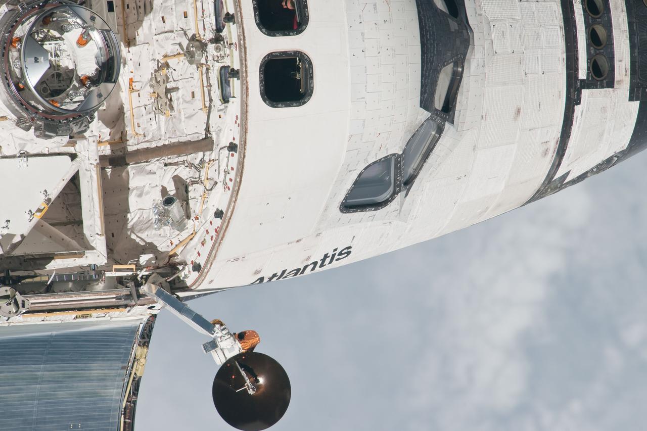
ISS028-E-015594 (10 July 2011) --- This is one of a series of images showing various parts of the space shuttle Atlantis in Earth orbit as photographed by one of three crew members -- half the station crew -- who were equipped with still cameras for this purpose on the International Space Station as the shuttle “posed” for photos and visual surveys and performed a back-flip for the rendezvous pitch maneuver (RPM). A 1000 millimeter lens was used to capture this particular series of images.

NASA's New Horizons spacecraft captured this high-resolution enhanced color view of Pluto on July 14, 2015. The image combines blue, red and infrared images taken by the Ralph/Multispectral Visual Imaging Camera (MVIC). Pluto's surface sports a remarkable range of subtle colors, enhanced in this view to a rainbow of pale blues, yellows, oranges, and deep reds. Many landforms have their own distinct colors, telling a complex geological and climatological story that scientists have only just begun to decode. The image resolves details and colors on scales as small as 0.8 miles (1.3 kilometers). http://photojournal.jpl.nasa.gov/catalog/PIA19952

jsc2023e010175 (2/28/2023) --- This image shows a monospecies biofilm through the view of a scanning electron microscope. The image was colored to visualize the bacterial cells (orange) embedded in the biofilm matrix (blue). The biofilm was formed by a strain of the bacterial species Staphylococcus capitis that was isolated from the International Space Station. The ESA-Biofilms investigation studies bacterial biofilm formation and antimicrobial properties of different metal surfaces under spaceflight conditions in altered gravity. The image was taken as part of the preflight experiments for ESA-Biofilms together with the Robert Koch Institute in Berlin, Germany. Image courtesy of DLR, CC BY-NC-ND 3.0.
NASA's New Horizons captured this high-resolution enhanced color view of Charon just before closest approach on July 14, 2015. The image combines blue, red and infrared images taken by the spacecraft's Ralph/Multispectral Visual Imaging Camera (MVIC); the colors are processed to best highlight the variation of surface properties across Charon. Charon's color palette is not as diverse as Pluto's; most striking is the reddish north (top) polar region, informally named Mordor Macula. Charon is 754 miles (1,214 kilometers) across; this image resolves details as small as 1.8 miles (2.9 kilometers). http://photojournal.jpl.nasa.gov/catalog/PIA19968
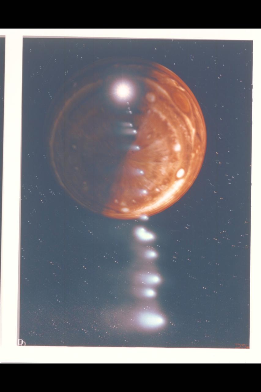
Photo Artwork composite by JPL This depiction of comet Shoemaker-Levy 9 impacting Jupiter is shown from several perspectives. IMAGE D depicts a generic view from Jupiter's south pole. For visual appeal, most of the large cometary fragments are shown close to one another in this image. At the time of Jupiter impact, the fragments will be separated from one another by serveral times the distances shown. This image was created by D.A. Seal of JPL's Mission Design Section using orbital computations provIded by P.W. Chodas and D.K. Yeomans of JPL's Navigation Section.
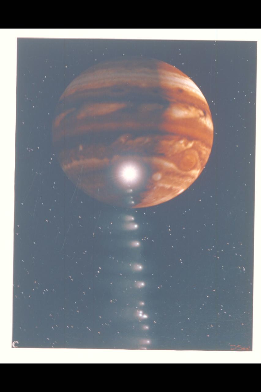
Photo Artwork composite by JPL This depiction of comet Shoemaker-Levy 9 impacting Jupiter is shown from several perspectives. IMAGE C is shown from the Voyager 2 spacecraft, which may observe the event from its unique position at the outer reaches of the solar system. For visual appeal, most of the large cometary fragments are shown close to one another in this image. At the time of Jupiter impact, the fragments will be separated from one another by serveral times the distances shown. This image was created by D.A. Seal of JPL's Mission Design Section using orbital computations provIded by P.W. Chodas and D.K. Yeomans of JPL's Navigation Section.
In this extended color image of Pluto taken by NASA New Horizons spacecraft, rounded and bizarrely textured mountains, informally named the Tartarus Dorsa, rise up along Pluto's day-night terminator and show intricate but puzzling patterns of blue-gray ridges and reddish material in between. This view, roughly 330 miles (530 kilometers) across, combines blue, red and infrared images taken by the Ralph/Multispectral Visual Imaging Camera (MVIC) on July 14, 2015, and resolves details and colors on scales as small as 0.8 miles (1.3 kilometers). http://photojournal.jpl.nasa.gov/catalog/PIA19957
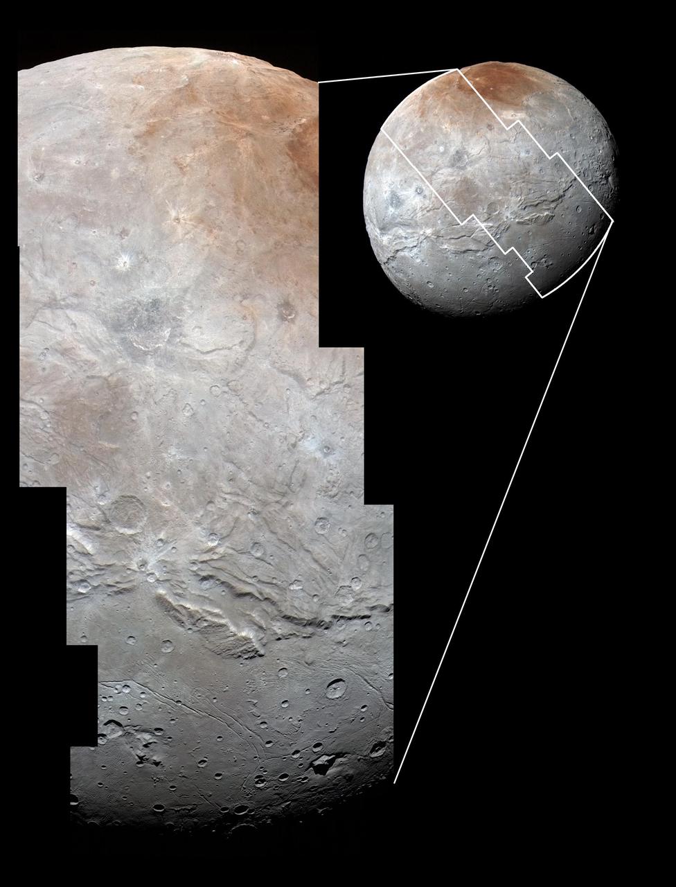
High-resolution images of Charon were taken by the Long Range Reconnaissance Imager (LORRI) on NASA's New Horizons spacecraft, shortly before closest approach on July 14, 2015, and overlaid with enhanced color from the Ralph/Multispectral Visual Imaging Camera (MVIC). Charon's cratered uplands at the top are broken by series of canyons, and replaced on the bottom by the rolling plains of the informally named Vulcan Planum. The scene covers Charon's width of 754 miles (1,214 kilometers) and resolves details as small as 0.5 miles (0.8 kilometers). http://photojournal.jpl.nasa.gov/catalog/PIA19967
![jsc2025e047405 (5/28/2025) --- Image of the preparative zone of cultured tobacco cells with visualized microtubules (yellow: microtubules [preparative zone], magenta: nuclei). For the Effects of the Space Environment on Cell Division in Plants (Plant Cell Division) investigation, plant samples are collected that are fixed and frozen for analysis of microstructures, microtubules, proteomes, and transcriptome and imaged using the JAXA Confocal Microscope (COSMIC). The Plant Cell Division investigation provides researchers with a better understanding of how gravity affects the body plan of plants could support production of food crops on future spaceflight missions. Image courtesy of University of Toyama.](https://images-assets.nasa.gov/image/jsc2025e047405/jsc2025e047405~thumb.jpg)
jsc2025e047405 (5/28/2025) --- Image of the preparative zone of cultured tobacco cells with visualized microtubules (yellow: microtubules [preparative zone], magenta: nuclei). For the Effects of the Space Environment on Cell Division in Plants (Plant Cell Division) investigation, plant samples are collected that are fixed and frozen for analysis of microstructures, microtubules, proteomes, and transcriptome and imaged using the JAXA Confocal Microscope (COSMIC). The Plant Cell Division investigation provides researchers with a better understanding of how gravity affects the body plan of plants could support production of food crops on future spaceflight missions. Image courtesy of University of Toyama.
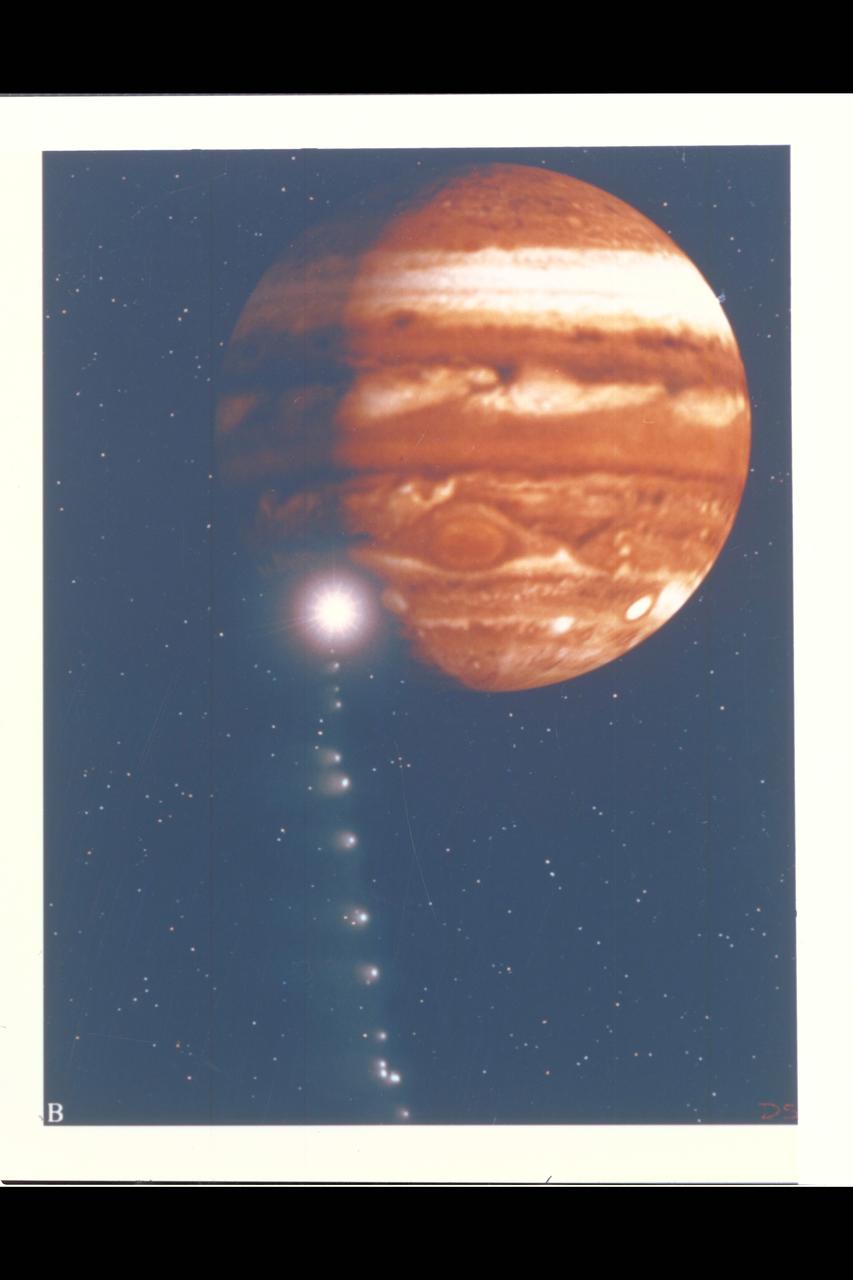
Photo Artwork composite by JPL This depiction of comet Shoemaker-Levy 9 impacting Jupiter is shown from several perspectives. IMAGE B shows the perspective from Galileo spacecraft which can observe the impact point directly. For visual appeal, most of the large cometary fragments are shown close to one another in this image. At the time of Jupiter impact, the fragments will be separated from one another by serveral times the distances shown. This image was created by D.A. Seal of JPL's Mission Design Section using orbital computations provIded by P.W. Chodas and D.K. Yeomans of JPL's Navigation Section.
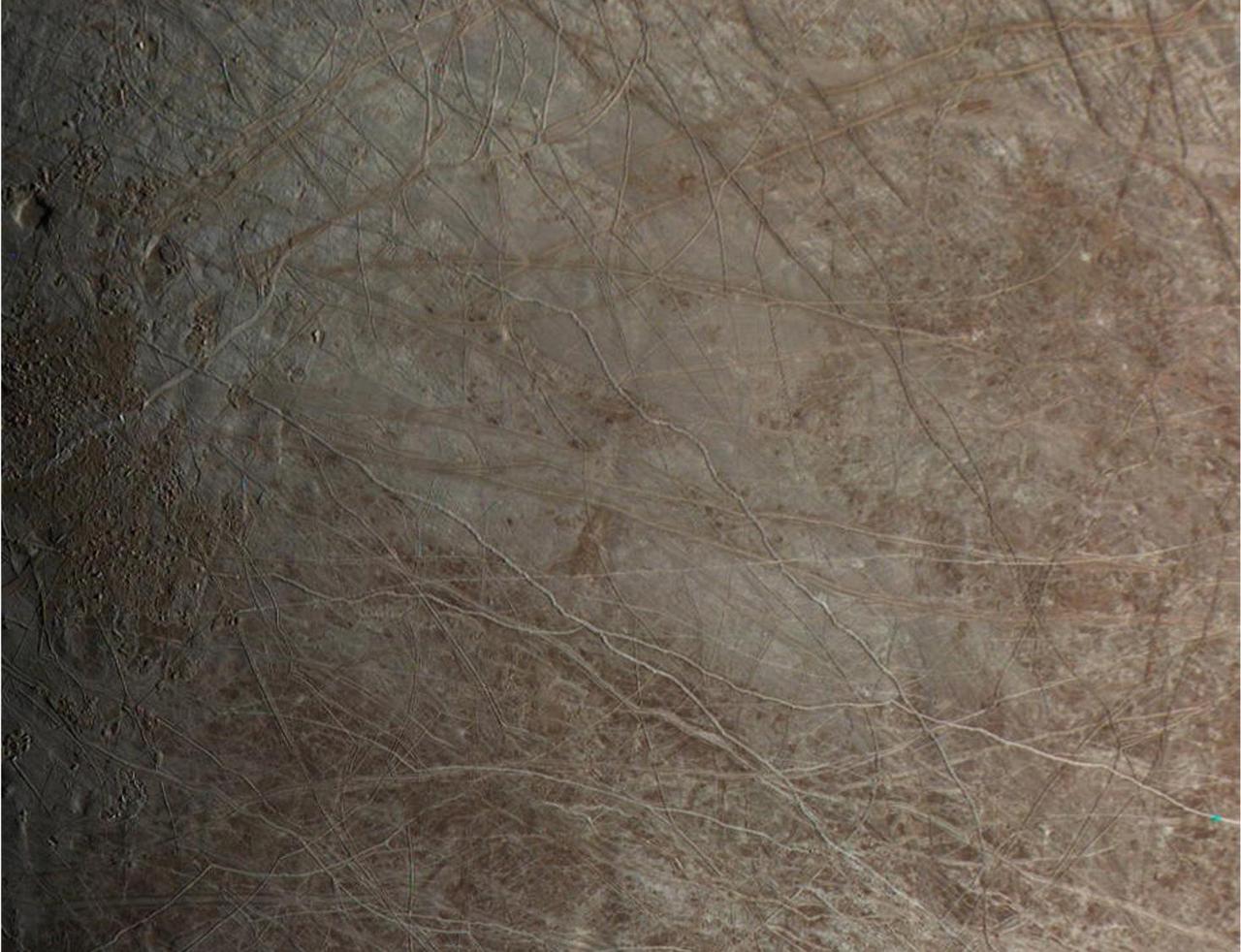
The surface of Jupiter's moon Europa is shown in an image from the JunoCam color public engagement camera aboard NASA's Juno spacecraft. The data for this image was taken Sept. 29, 2022. During its flybys in the late 1990s and 2000, NASA's Galileo mission mapped much of Jupiter's moon Europa at a resolution of 0.6 miles per pixel (1 kilometer per pixel) or better, but there are some patches that were imaged only at low resolution. Images from JunoCam have now filled in one of those regions, shown here. Cracks, ridges, and bands show up clearly, and can be visually traced across images to match up to the cracks and ridges that appear in the earlier Galileo images. The way these features crosscut the surface can reveal which sections of the terrain are younger and which are older, helping scientists to fill in Europa's tectonic history. Paul Schenk processed the images. https://photojournal.jpl.nasa.gov/catalog/PIA25696
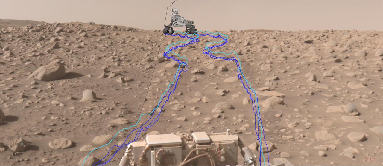
This annotated composite image shows the path NASA's Perseverance Mars rover took through a dense section of boulders. It was acquired on June 29, 2023, the 838th day, or sol, of the mission, by one of the rover's navigation cameras and was annotated using the Robot Sequencing and Visualization Program. The pale blue line indicates the course of the center of the rover's front wheel hubs, while the darker blue lines show the paths taken by the bottom of the rover's six wheels. With the help of its self-driving autonomous navigation system, AutoNav, Perseverance traversed the boulder field much more quickly than previous rovers could have. A key objective for Perseverance's mission on Mars is astrobiology, including the search for signs of ancient microbial life. The rover will characterize the planet's geology and past climate, pave the way for human exploration of the Red Planet, and be the first mission to collect and cache Martian rock and regolith (broken rock and dust). Subsequent NASA missions, in cooperation with ESA (European Space Agency), would send spacecraft to Mars to collect these sealed samples from the surface and return them to Earth for in-depth analysis. The Mars 2020 Perseverance mission is part of NASA's Moon to Mars exploration approach, which includes Artemis missions to the Moon that will help prepare for human exploration of the Red Planet. https://photojournal.jpl.nasa.gov/catalog/PIA26071
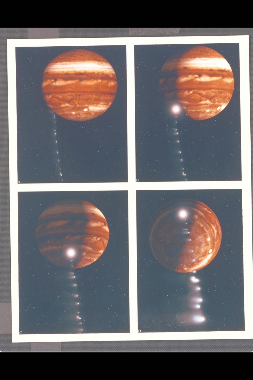
Photo Artwork composite by JPL This depiction of comet Shoemaker-Levy 9 impacting Jupiter is shown from several perspectives. IMAGE A is shown from the perspective of Earth based observers. IMAGE B shows the perspective from Galileo spacecraft which can observe the impact point directly. IMAGE C is shown from the Voyager 2 spacecraft, which may observe the event from its unique position at the outer reaches of the solar system. IMAGE D depicts a generic view from Jupiter's south pole. For visual appeal, most of the large cometary fragments are shown close to one another in this image. At the time of Jupiter impact, the fragments will be separated from one another by serveral times the distances shown. This image was created by D.A. Seal of JPL's Mission Design Section using orbital computations provIded by P.W. Chodas and D.K. Yeomans of JPL's Navigation Section.

Juno's Radiation Monitoring Investigation used the Stellar Reference Unit (SRU) star camera to collect this high-resolution image of the dark side of Jupiter during Perijove 11 on Feb. 7, 2018. The clouds are illuminated by moonlight from Jupiter's moon Io and the two bright spots on the right side of the image are flashes of Jovian lightning. Juno was only 41,000 miles (66,000 kilometers) from the cloud tops when this SRU image was collected. The left side of the composite image shows a 3-dimensional visualization of Jupiter's Northern hemisphere with its northern aurora included. To the right of the aurora and solar terminator line, is a box illustrating the position of the SRU field of view at the time the image was taken. Further to the right is an exploded view of the SRU image. https://photojournal.jpl.nasa.gov/catalog/PIA22965
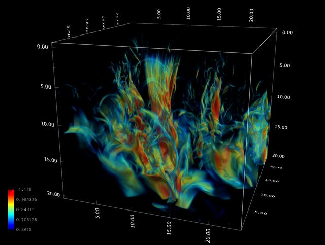
Stein_Sun: Visualization of the complex magnetic field produced as magnetic flux rises toward the Sun¹s surface from the deep convection zone. The image shows a snapshot of how the magnetic field has evolved two days from the time uniform, untwisted, horizontal magnetic field started to be advected by inflows at the bottom (20 megameters deep). Axes are in megameters, and the color scale shows the log of the magnetic field strength. Credit: Robert Stein, Michigan State University; Tim Sandstrom, NASA/Ames
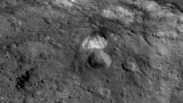
Among the highest features seen on Ceres so far is a mountain about 4 miles (6 kilometers) high, which is roughly the elevation of Mount McKinley in Alaska's Denali National Park. This image comes from an animation, shown in PIA19619, generated using data from NASA's Dawn spacecraft. Vertical relief has been exaggerated by a factor of five. Exaggerating the relief helps scientists understand and visualize the topography much more easily, and highlights features that are sometimes subtle. http://photojournal.jpl.nasa.gov/catalog/PIA19618
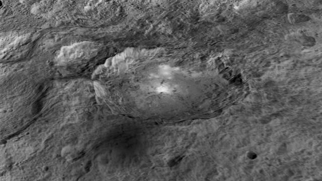
The intriguing brightest spots on Ceres lie in a crater named Occator, which is about 60 miles (90 kilometers) across and 2 miles (4 kilometers) deep. This image comes from an animation, shown in PIA19619, generated using data from NASA's Dawn spacecraft. Vertical relief has been exaggerated by a factor of five. Exaggerating the relief helps scientists understand and visualize the topography much more easily, and highlights features that are sometimes subtle. http://photojournal.jpl.nasa.gov/catalog/PIA19617
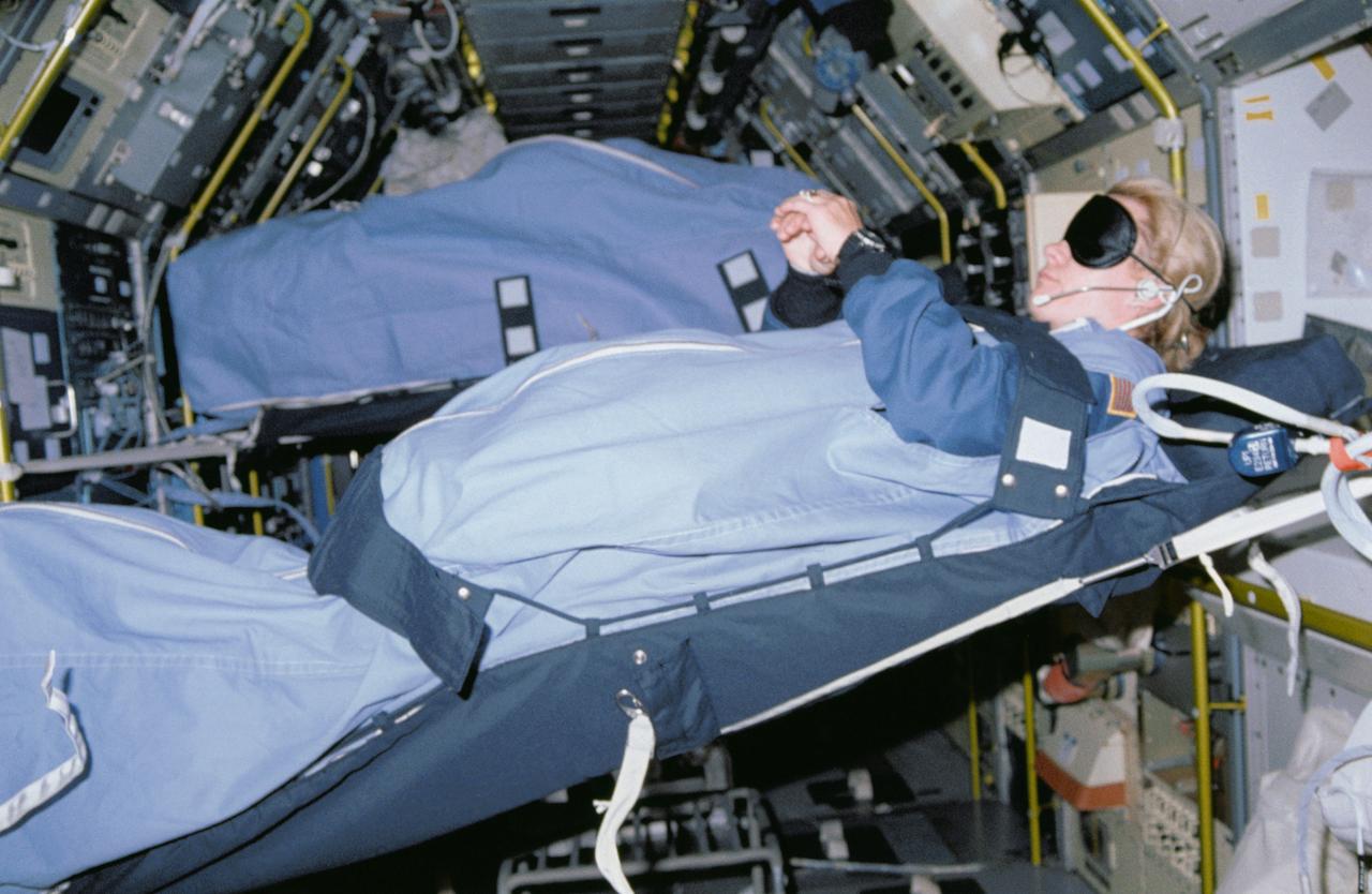
STS040-31-020 (5-14 June 1991) --- During the nine-day mission, some of the crew slept in the SLS-1 module. Astronaut Rhea Seddon, using various restraints, sleeps horizontally in this scene. The image was one of 25 visuals used by the STS-40 crew at its Post Flight Press Conference (PFPC) on June 28, 1991.
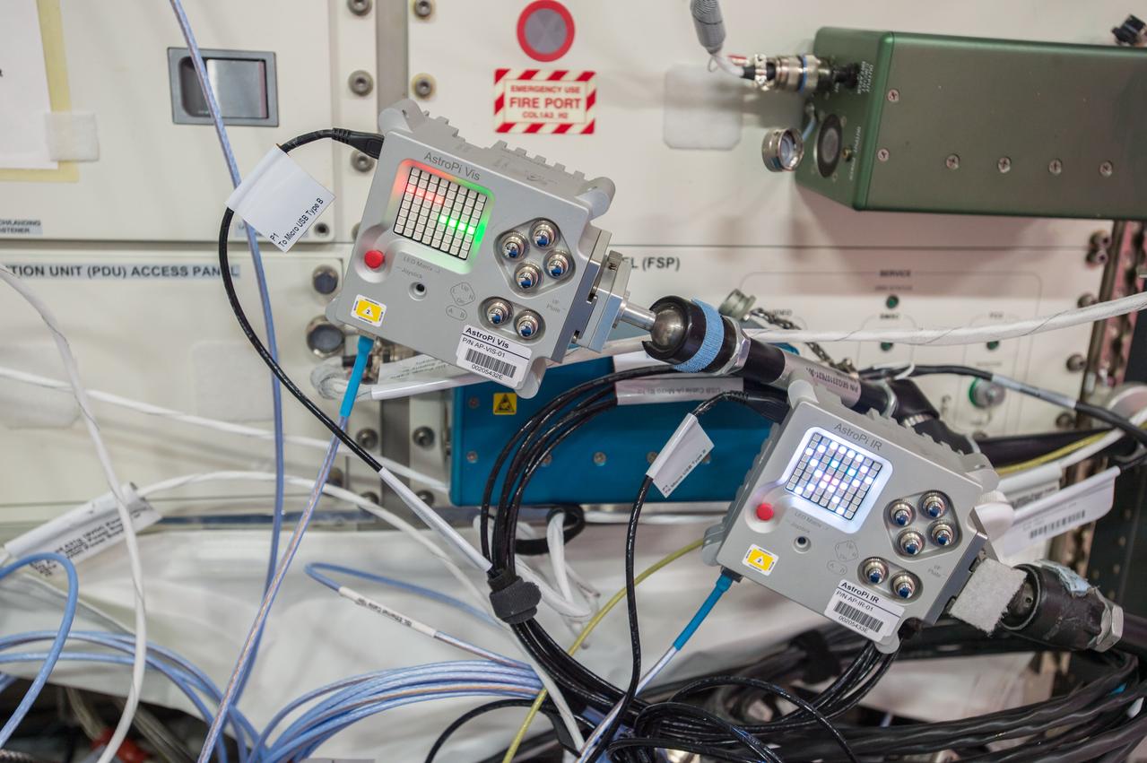
iss051e037699 (5/4/2017) --- A view of two AstroPi Raspberry Pi computers equipped with Visual and Infrared Cameras. The image was taken during ongoing European Space Agency Education Payload Operation-Pesquet (ESA-EPO-Pesquet) activities in the Columbus European Laboratory. The activities related to this project are intended to encourage and strengthen the teaching of computing and coding curriculums, and through this stimulate the curiosity of students and motivate them towards further study of STEM (Science, Technology, Engineering and Mathematics) subjects.
View of Canadian Space Agency (CSA) Chris Hadfield,Expedition 34 Flight Engineer (FE),unpacking ISS SERVIR Environmental Research and Visualization System (ISERV) in the U.S. Laboratory. ISERV is a fully automated image data acquisition system in the Window Observational Research Facility (WORF) rack. Kevin Ford,Expedition 34 Commander is visible on the right of frame. Photo was taken during Expedition 34.
View of Canadian Space Agency (CSA) Chris Hadfield,Expedition 34 Flight Engineer (FE), preparing to setup the ISS SERVIR Environmental Research and Visualization System (ISERV) in the U.S. Laboratory. ISERV is a fully automated image data acquisition system in the Window Observational Research Facility (WORF) rack. Kevin Ford,Expedition 34 Commander is visible on the right of frame. Photo was taken during Expedition 34.