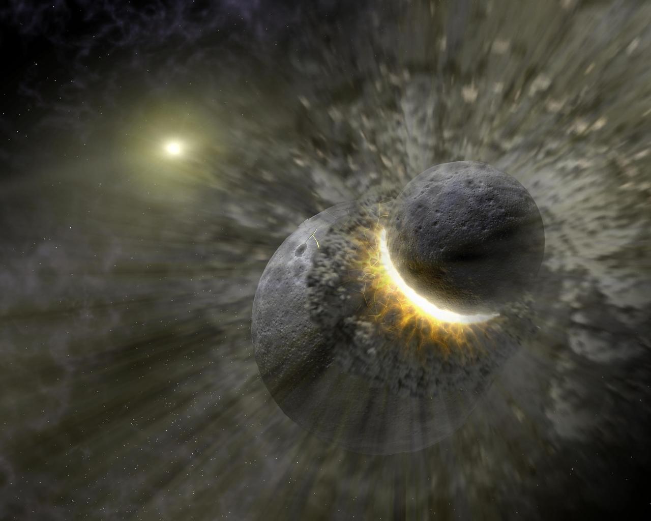
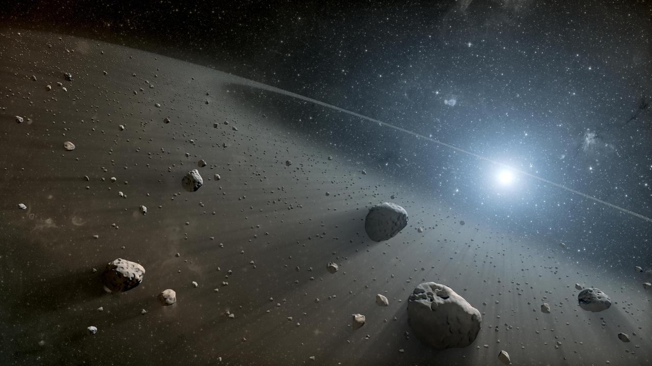
This artist concept illustrates how a massive collision of objects perhaps as large as the planet Pluto smashed together to create the dust ring around the nearby star Vega. New observations from NASA's Spitzer Space Telescope indicate the collision took place within the last one million years. Astronomers think that embryonic planets smashed together, shattered into pieces, and repeatedly crashed into other fragments to create ever finer debris. In the image, a collision is seen between massive objects that measured up to 2,000 kilometers (about 1,200 miles) in diameter. Scientists say the big collision initiated subsequent collisions that created dust particles around the star that were a few microns in size. Vega's intense light blew these fine particles to larger distances from the star, and also warmed them to emit heat radiation that can be detected by Spitzer's infrared detectors. http://photojournal.jpl.nasa.gov/catalog/PIA07217

B-33 Vega Turrets. Photo are listed in the NACA Wartime report L-463, October 1942, Test of a Large Spherical Turret and a modified Turret on a Typical Bomber Fuselage by Axel T. Mattson.
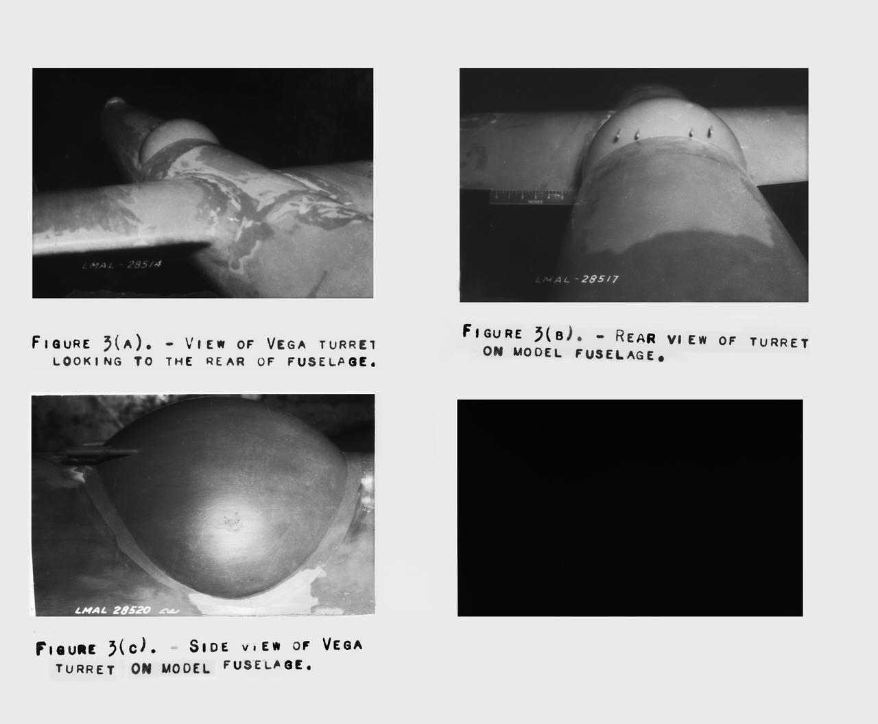
B-33 Vega Turrets. Photo are listed in the NACA Wartime report L-463, October 1942, Test of a Large Spherical Turret and a modified Turret on a Typical Bomber Fuselage by Axel T. Mattson.
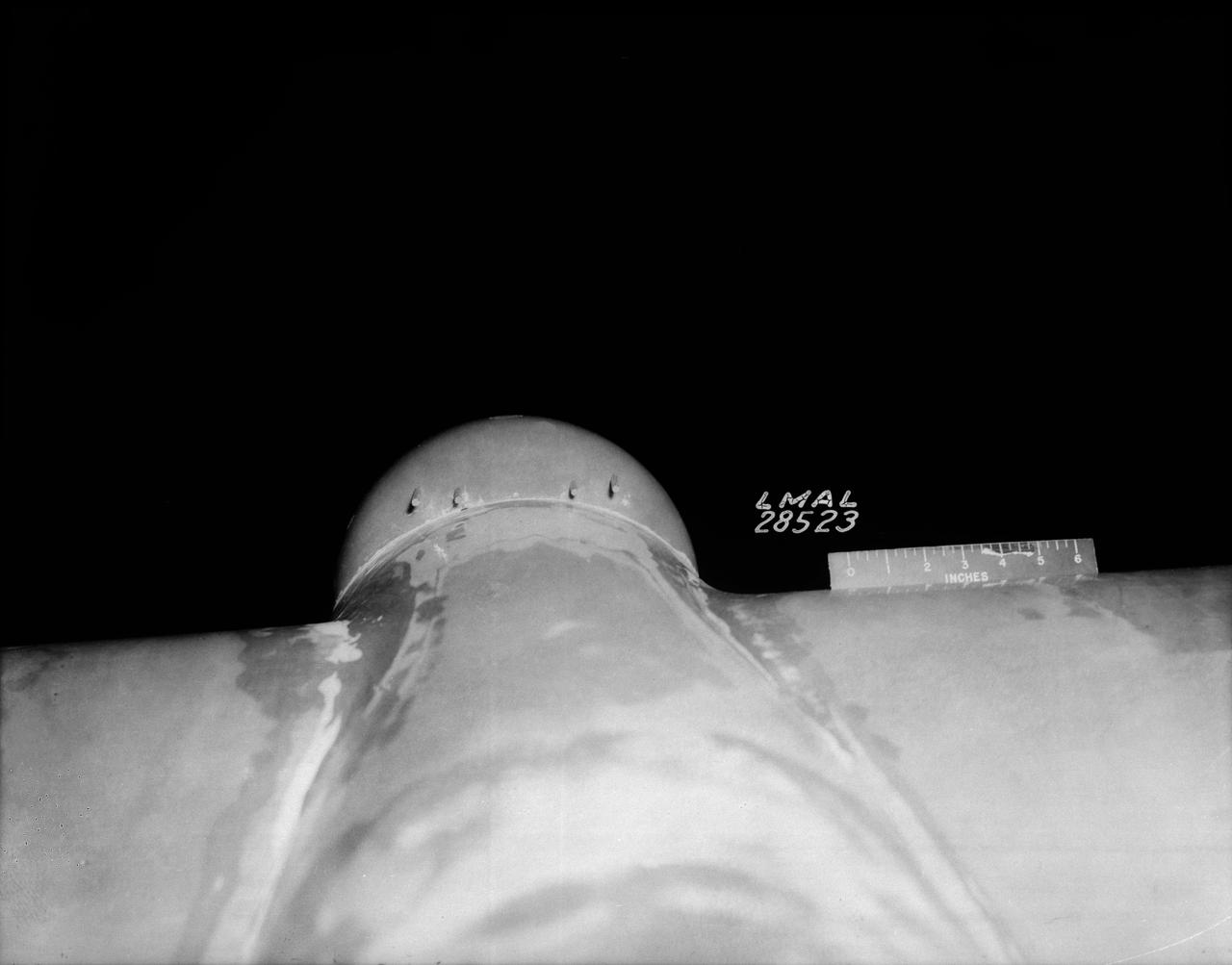
B-33 Vega Turrets. Photo are listed in the NACA Wartime report L-463, October 1942, Test of a Large Spherical Turret and a modified Turret on a Typical Bomber Fuselage by Axel T. Mattson.
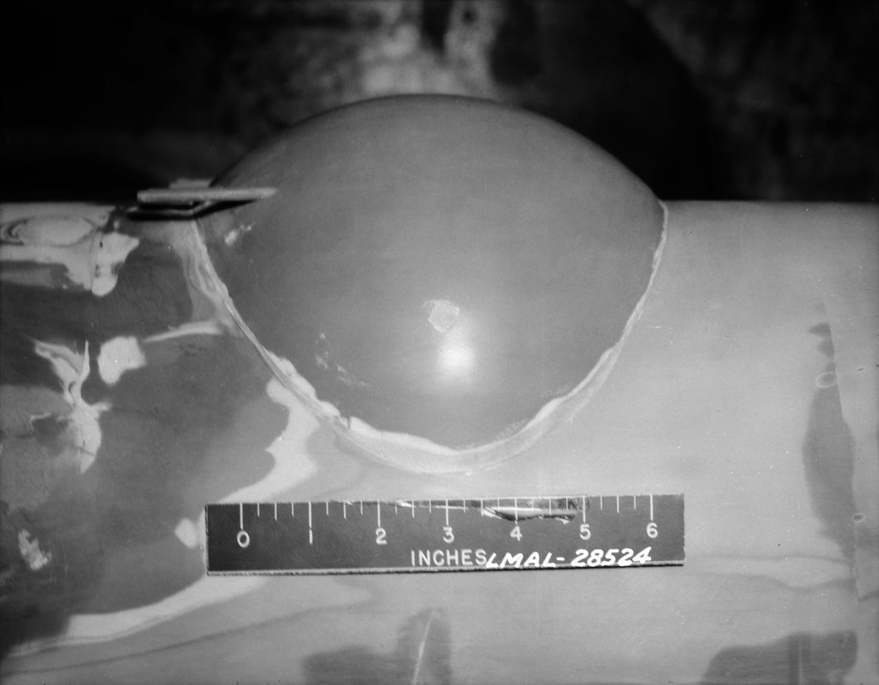
B-33 Vega Turrets. Photo are listed in the NACA Wartime report L-463, October 1942, Test of a Large Spherical Turret and a modified Turret on a Typical Bomber Fuselage by Axel T. Mattson.
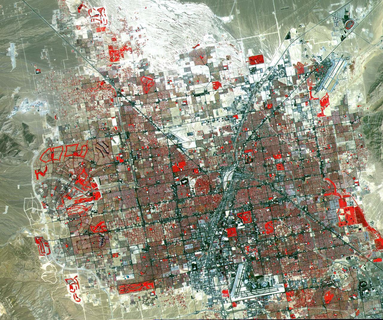
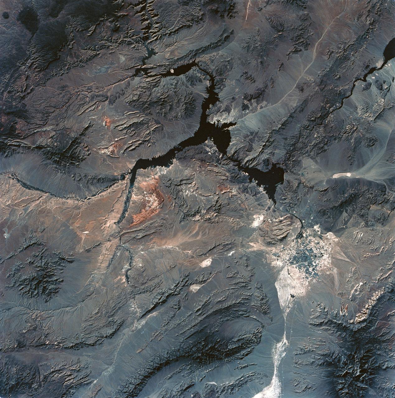
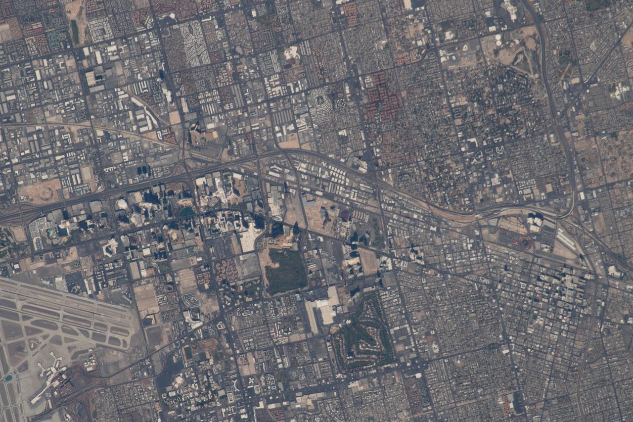
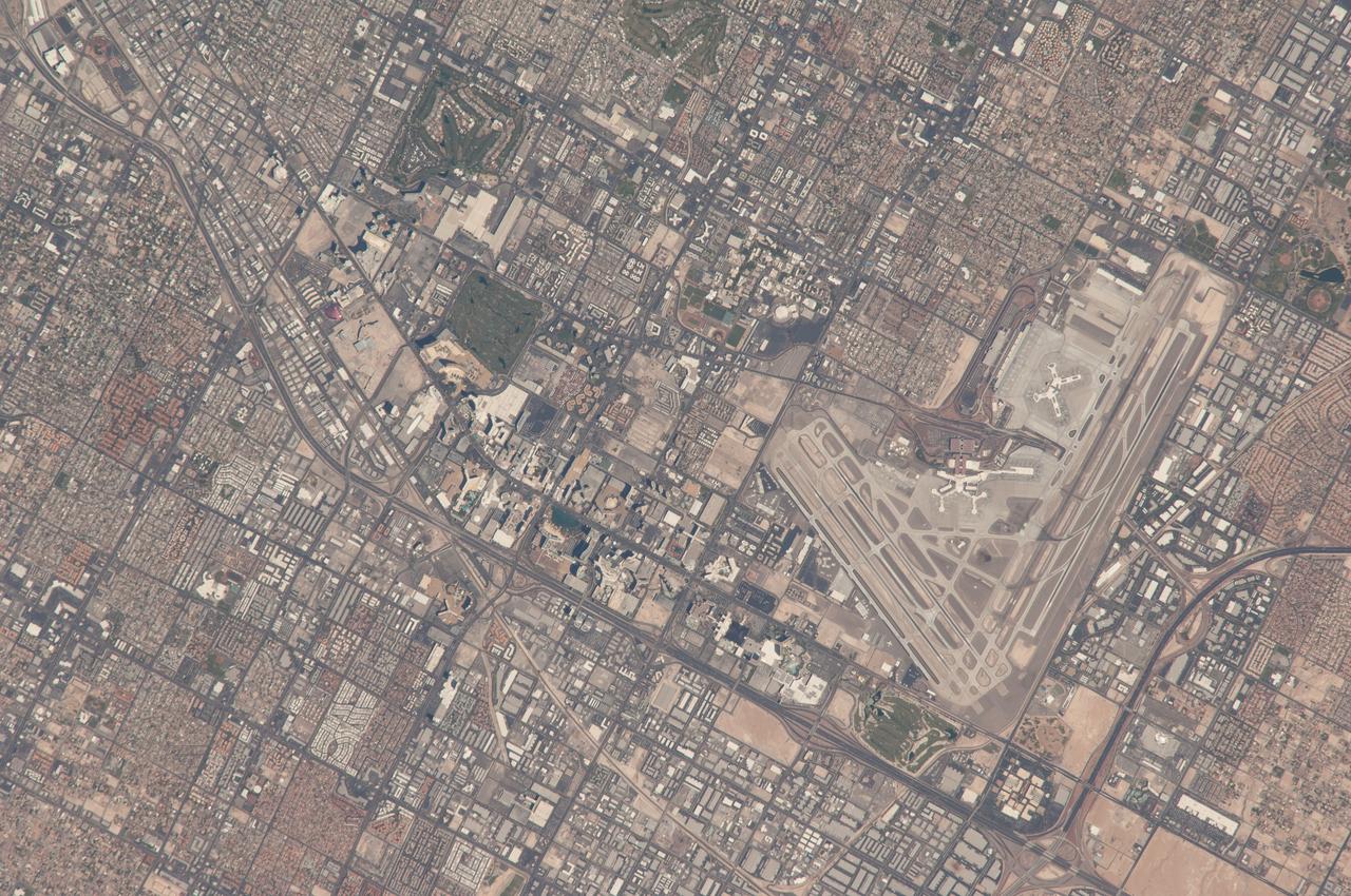
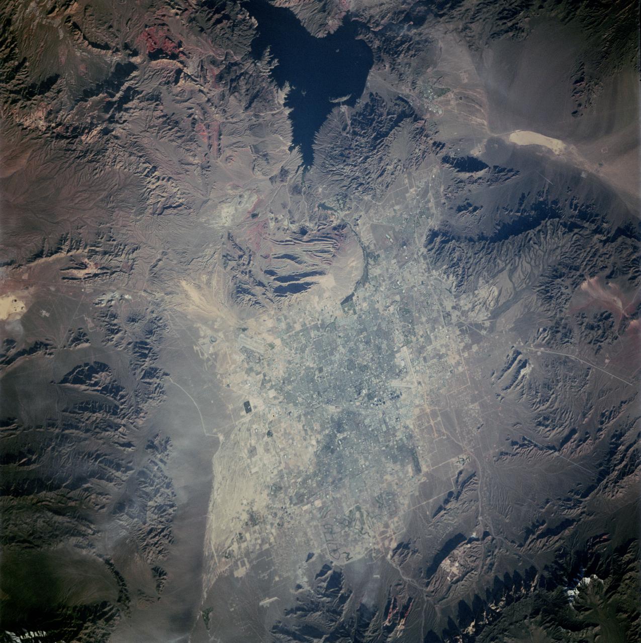
This image of Las Vegas, NV was acquired on August, 2000 and covers an area 42 km (25 miles) wide and 30 km (18 miles) long. The image displays three bands of the reflected visible and infrared wavelength region, with a spatial resolution of 15 m. McCarran International Airport to the south and Nellis Air Force Base to the NE are the two major airports visible. Golf courses appear as bright red areas of worms. The first settlement in Las Vegas (which is Spanish for The Meadows) was recorded back in the early 1850s when the Mormon church, headed by Brigham Young, sent a mission of 30 men to construct a fort and teach agriculture to the Indians. Las Vegas became a city in 1905 when the railroad announced this city was to be a major division point. Prior to legalized gambling in 1931, Las Vegas was developing as an agricultural area. Las Vegas' fame as a resort area became prominent after World War II. The image is located at 36.1 degrees north latitude and 115.1 degrees west longitude. http://photojournal.jpl.nasa.gov/catalog/PIA11096
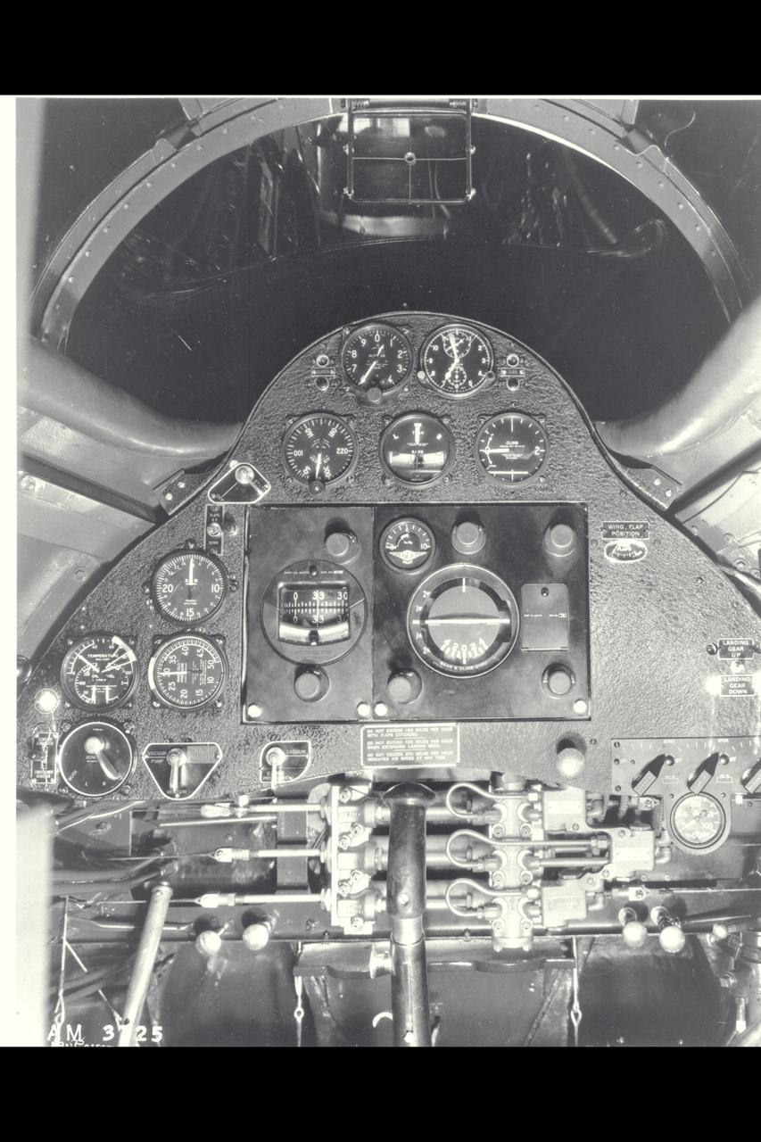
Lockheed Vega Cockpit
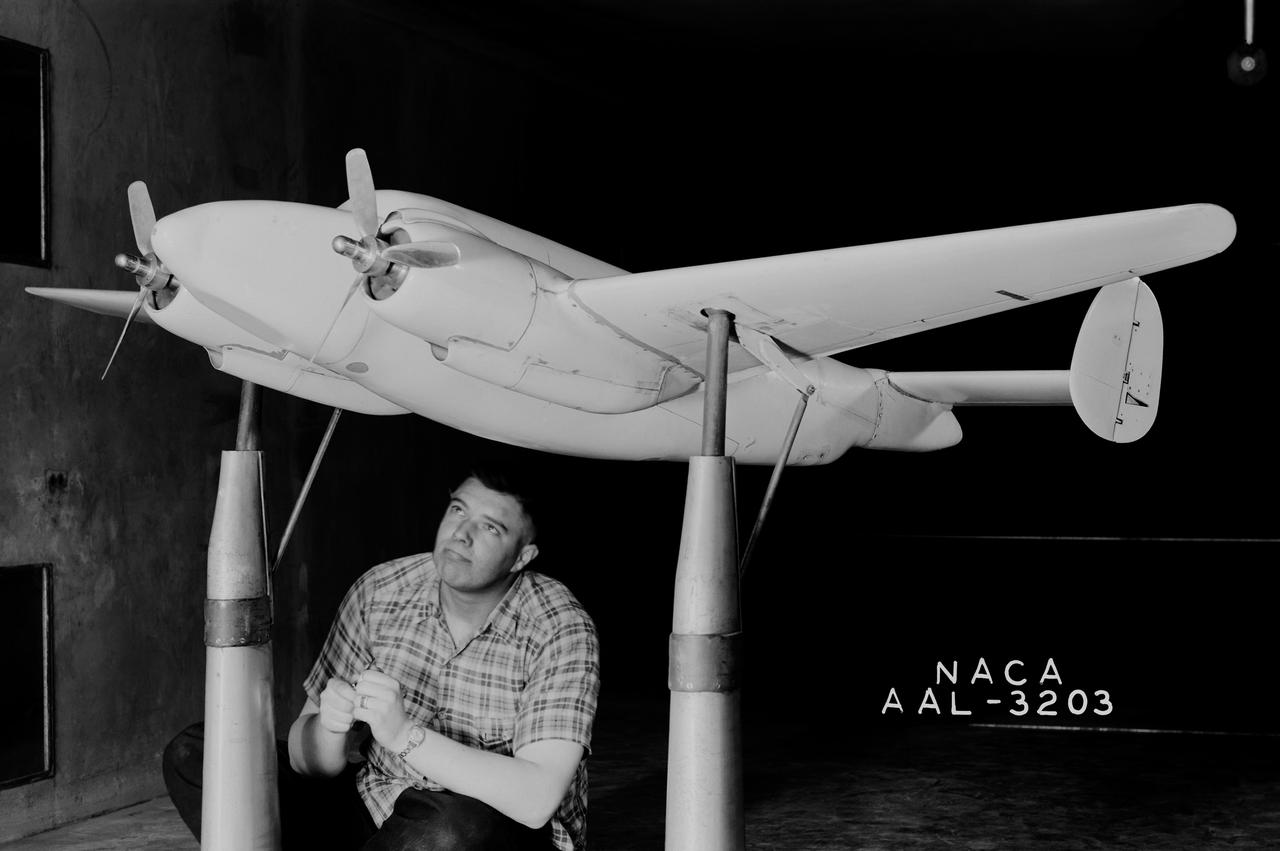
Vega XPV-2 complete model testing in the 7x10ft w.t. @ Ames Research Center, Moffett Field, CA

Over the years of the Landsat program, the desert city of Las Vegas has gone through a massive growth spurt. The outward expansion of the city over the last quarter of a century is shown here with two false-color Landsat 5 images (August 3, 1984, and November 2, 2011). The dark purple grid of city streets and the green of irrigated vegetation grow out in every direction into the surrounding desert. These images were created using reflected light from the shortwave infrared, near-infrared, and green portions of the electromagnetic spectrum (Landsat 5 TM bands 7,4,2). ---- NASA and the U.S. Department of the Interior through the U.S. Geological Survey (USGS) jointly manage Landsat, and the USGS preserves a 40-year archive of Landsat images that is freely available over the Internet. The next Landsat satellite, now known as the Landsat Data Continuity Mission (LDCM) and later to be called Landsat 8, is scheduled for launch in 2013. In honor of Landsat’s 40th anniversary in July 2012, the USGS released the LandsatLook viewer – a quick, simple way to go forward and backward in time, pulling images of anywhere in the world out of the Landsat archive. <b><a href="http://www.nasa.gov/audience/formedia/features/MP_Photo_Guidelines.html" rel="nofollow">NASA image use policy.</a></b> <b><a href="http://www.nasa.gov/centers/goddard/home/index.html" rel="nofollow">NASA Goddard Space Flight Center</a></b> enables NASA’s mission through four scientific endeavors: Earth Science, Heliophysics, Solar System Exploration, and Astrophysics. Goddard plays a leading role in NASA’s accomplishments by contributing compelling scientific knowledge to advance the Agency’s mission. <b>Follow us on <a href="http://twitter.com/NASA_GoddardPix" rel="nofollow">Twitter</a></b> <b>Like us on <a href="http://www.facebook.com/pages/Greenbelt-MD/NASA-Goddard/395013845897?ref=tsd" rel="nofollow">Facebook</a></b> <b>Find us on <a href="http://instagrid.me/nasagoddard/?vm=grid" rel="nofollow">Instagram</a></b>
This artist concept illustrates an asteroid belt around the bright star Vega. Evidence for this warm ring of debris was found using NASA Spitzer Space Telescope, and the European Space Agency Herschel Space Observatory.
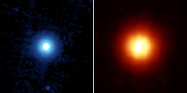
NASA's Spitzer Space Telescope recently captured these images of the star Vega, located 25 light years away in the constellation Lyra. Spitzer was able to detect the heat radiation from the cloud of dust around the star and found that the debris disc is much larger than previously thought. This side by side comparison, taken by Spitzer's multiband imaging photometer, shows the warm infrared glows from dust particles orbiting the star at wavelengths of 24 microns (figure 2 in blue) and 70 microns (figure 3 in red). Both images show a very large, circular and smooth debris disc. The disc radius extends to at least 815 astronomical units. (One astronomical unit is the distance from Earth to the Sun, which is 150-million kilometers or 93-million miles). Scientists compared the surface brightness of the disc in the infrared wavelengths to determine the temperature distribution of the disc and then infer the corresponding particle size in the disc. Most of the particles in the disc are only a few microns in size, or 100 times smaller than a grain of Earth sand. These fine dust particles originate from collisions of embryonic planets near the star at a radius of approximately 90 astronomical units, and are then blown away by Vega's intense radiation. The mass and short lifetime of these small particles indicate that the disc detected by Spitzer is the aftermath of a large and relatively recent collision, involving bodies perhaps as big as the planet Pluto. The images are 3 arcminutes on each side. North is oriented upward and east is to the left. http://photojournal.jpl.nasa.gov/catalog/PIA07218
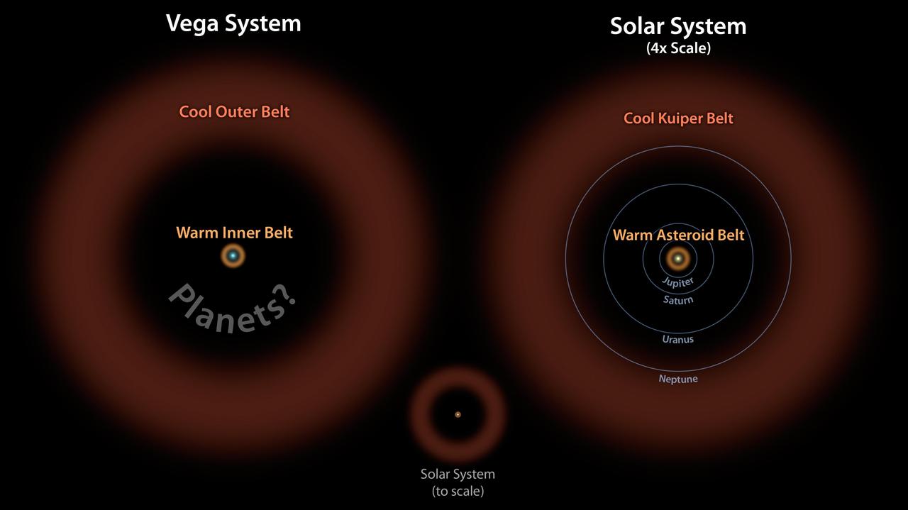
In this diagram, the Vega system, which was already known to have a cooler outer belt of comets orange, is compared to our solar system with its asteroid and Kuiper belts. The ring of warm, rocky debris was detected using NASA Spitzer Space Telescope,
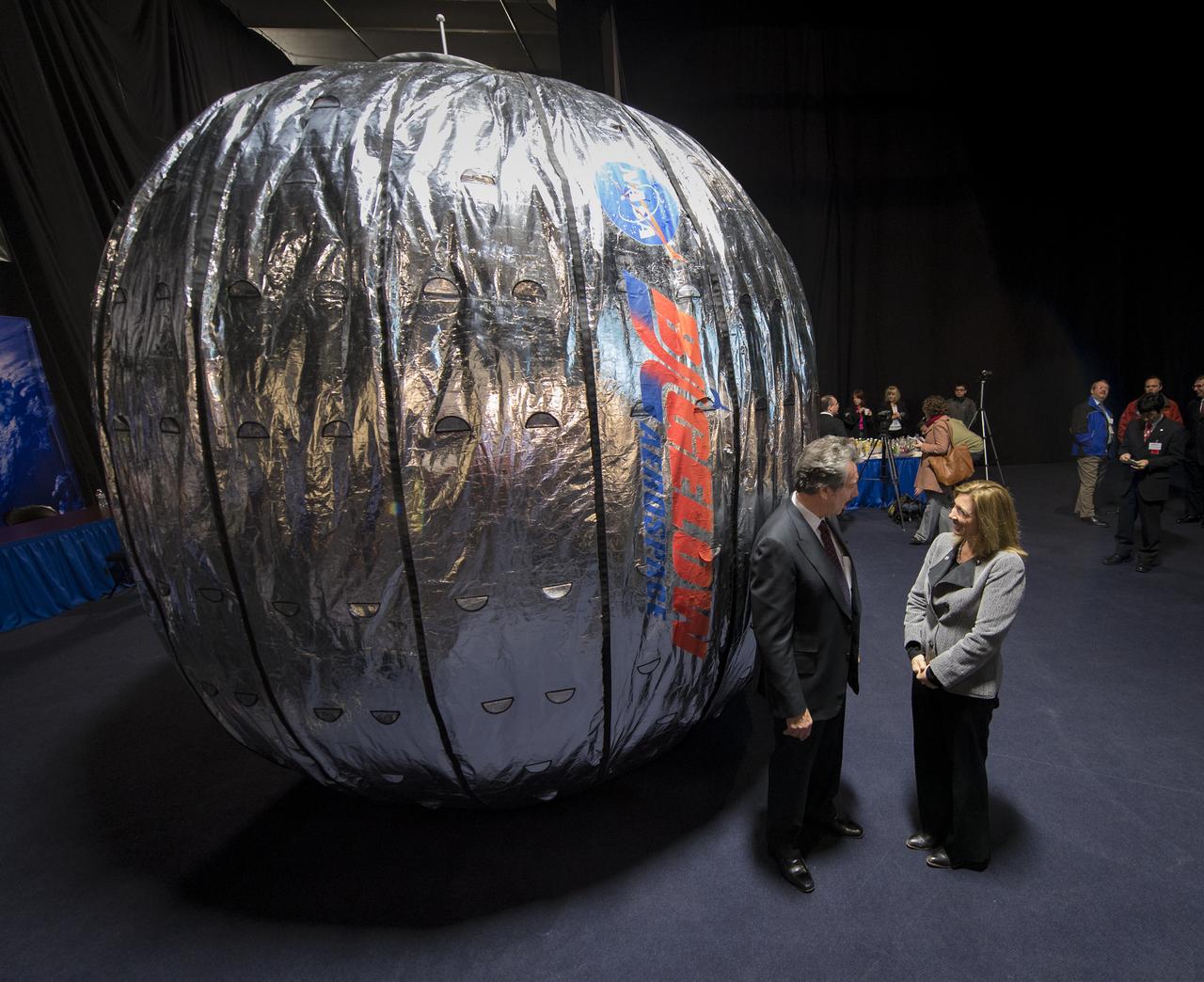
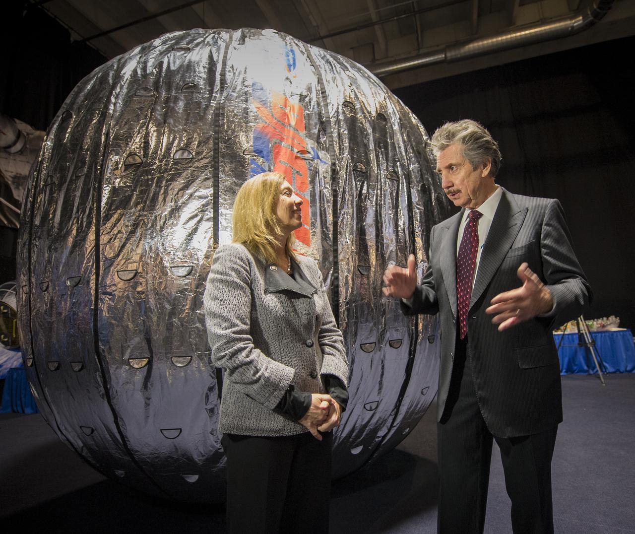
NASA Deputy Administrator Lori Garver views the inside of a full scale mockup of Bigelow Aerospace's Space Station Alpha during a tour of the Bigelow Aerospace facilities by the company's President Robert Bigelow on Friday, Feb. 4, 2011, in Las Vegas. NASA has been discussing potential partnership opportunities with Bigelow for its inflatable habitat technologies as part of NASA's goal to develop innovative technologies to ensure that the U.S. remains competitive in future space endeavors. Photo Credit: (NASA/Bill Ingalls)

NASA Deputy Administrator Lori Garver talks during a press conference shortly after she was given a tour of the Bigelow Aerospace facilities by the company's President Robert Bigelow on Friday, Feb. 4, 2011, in Las Vegas. NASA has been discussing potential partnership opportunities with Bigelow for its inflatable habitat technologies as part of NASA's goal to develop innovative technologies to ensure that the U.S. remains competitive in future space endeavors. Photo Credit: (NASA/Bill Ingalls)

President and founder of Bigelow Aerospace Robert T. Bigelow, talks during a media briefing where he and NASA Deputy Administrator Lori Garver discussed their $17.8 million contract to provide a Bigelow Expandable Activity Module (BEAM) to the International Space Station to test expandable space habitat technology, Wednesday, Jan. 16, 2013 at Bigelow Aerospace in Las Vegas. BEAM is scheduled to arrive at the space station in 2015 for a two-year technology demonstration. Photo Credit: (NASA/Bill Ingalls)

Bigelow Aerospace President Robert Bigelow talks during a press conference shortly after he and NASA Deputy Administrator Lori Garver toured the Bigelow Aerospace facilities on Friday, Feb. 4, 2011, in Las Vegas. NASA has been discussing potential partnership opportunities with Bigelow for its inflatable habitat technologies as part of NASA's goal to develop innovative technologies to ensure that the U.S. remains competitive in future space endeavors. Photo Credit: (NASA/Bill Ingalls)

NASA Deputy Administrator Lori Garver talks during a media briefing where she and President and founder of Bigelow Aerospace Robert T. Bigelow, discussed their $17.8 million contract to provide a Bigelow Expandable Activity Module (BEAM) to the International Space Station to test expandable space habitat technology, Wednesday, Jan. 16, 2013 at Bigelow Aerospace in Las Vegas. BEAM is scheduled to arrive at the space station in 2015 for a two-year technology demonstration. Photo Credit: (NASA/Bill Ingalls)
iss072e399146 (Dec. 19, 2024) --- Downtown Las Vegas, Nevada, with its famous well-lit strip and Harry Reid International Airport at center, is pictured at approximately 4:16 a.m. local time from the International Space Station as it orbited 256 miles above.
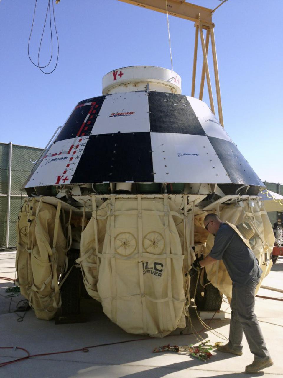
LAS VEGAS, Nev. – An engineer prepares a mock-up of The Boeing Company's CST-100 spacecraft for the third and final series of simulated contingency water landing scenarios at Bigelow Aerospace's headquarters near Las Vegas. The CST-100 is designed for ground landings, but could splash down on the water, if necessary. The tests are part of the company’s ongoing work supporting its funded Space Act Agreement with NASA’s Commercial Crew Program, or CCP, during the Commercial Crew Integrated Capability, or CCiCap, initiative. CCP is intended to lead to the availability of commercial human spaceflight services for government and commercial customers to low-Earth orbit. Future development and certification initiatives eventually will lead to the availability of human spaceflight services for NASA to send its astronauts to the International Space Station, where critical research is taking place daily. For more information about CCP, go to http://www.nasa.gov/commercialcrew. Photo credit: Boeing/Kelly George
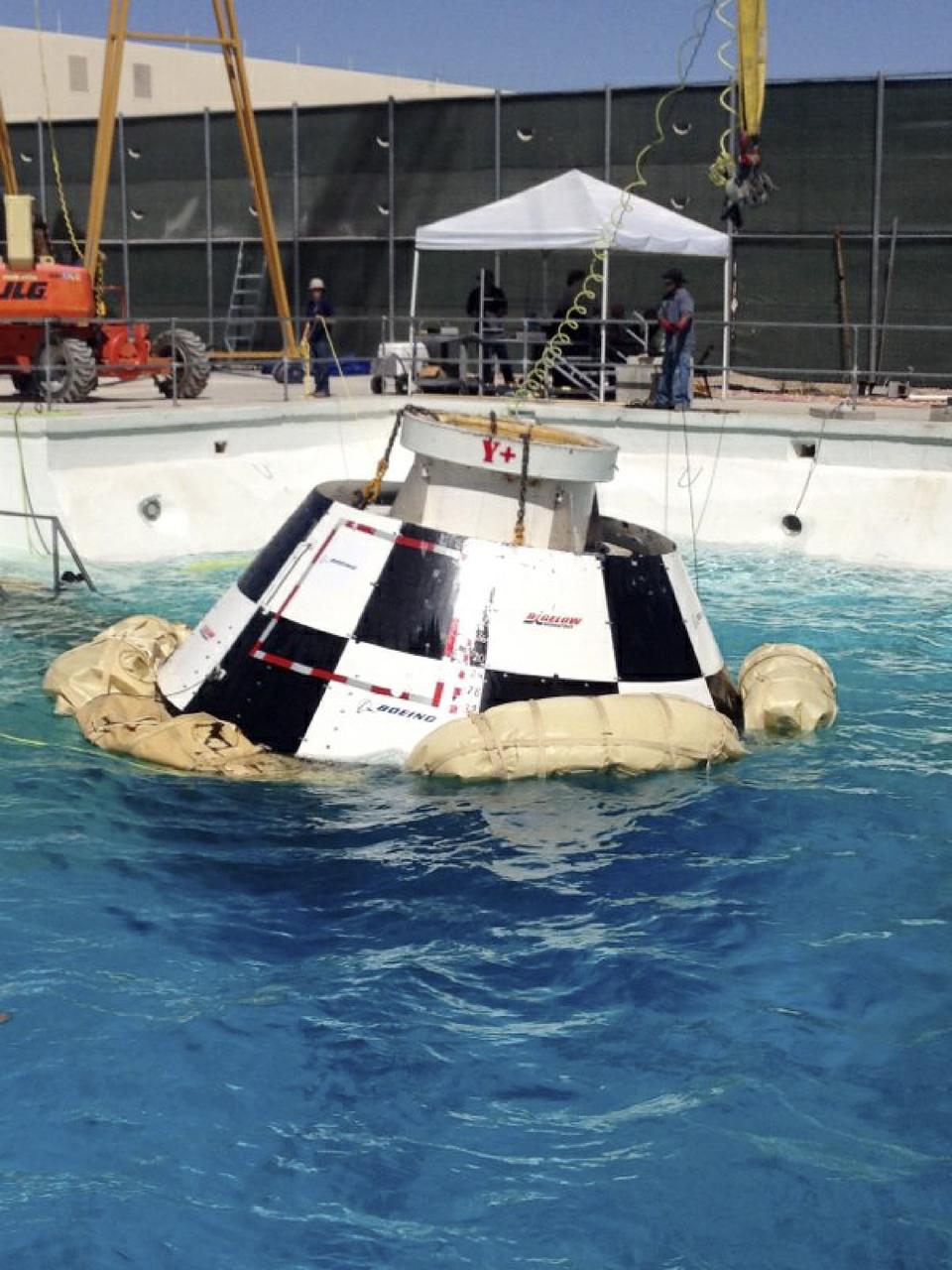
LAS VEGAS, Nev. – A mock-up of The Boeing Company's CST-100 spacecraft floats following the third and final series of simulated contingency water landing scenarios at Bigelow Aerospace's headquarters near Las Vegas. The CST-100 is designed for ground landings, but could splash down on the water, if necessary. The tests are part of the company’s ongoing work supporting its funded Space Act Agreement with NASA’s Commercial Crew Program, or CCP, during the Commercial Crew Integrated Capability, or CCiCap, initiative. CCP is intended to lead to the availability of commercial human spaceflight services for government and commercial customers to low-Earth orbit. Future development and certification initiatives eventually will lead to the availability of human spaceflight services for NASA to send its astronauts to the International Space Station, where critical research is taking place daily. For more information about CCP, go to http://www.nasa.gov/commercialcrew. Photo credit: Boeing/Kelly George
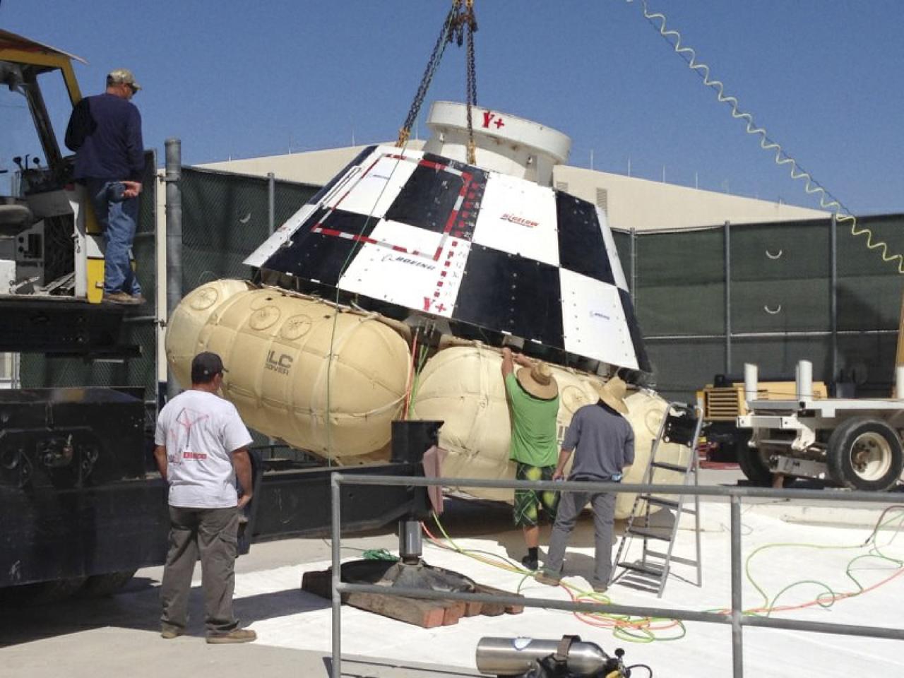
LAS VEGAS, Nev. – Engineers prepare a mock-up of The Boeing Company's CST-100 spacecraft for the third and final series of simulated contingency water landing scenarios at Bigelow Aerospace's headquarters near Las Vegas. The CST-100 is designed for ground landings, but could splash down on the water, if necessary. The tests are part of the company’s ongoing work supporting its funded Space Act Agreement with NASA’s Commercial Crew Program, or CCP, during the Commercial Crew Integrated Capability, or CCiCap, initiative. CCP is intended to lead to the availability of commercial human spaceflight services for government and commercial customers to low-Earth orbit. Future development and certification initiatives eventually will lead to the availability of human spaceflight services for NASA to send its astronauts to the International Space Station, where critical research is taking place daily. For more information about CCP, go to http://www.nasa.gov/commercialcrew. Photo credit: Boeing/Kelly George
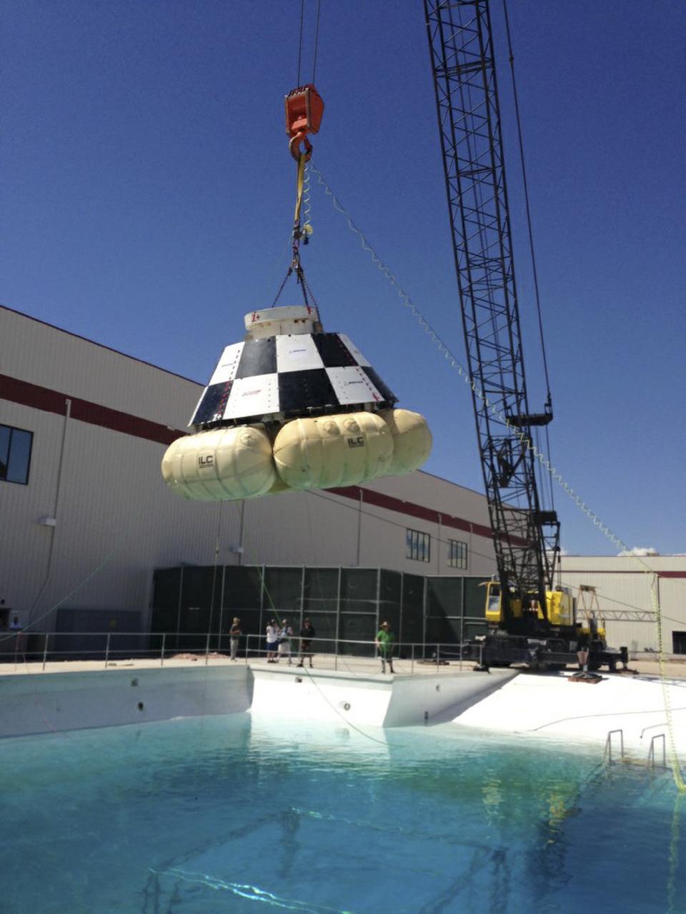
LAS VEGAS, Nev. – A mock-up of The Boeing Company's CST-100 spacecraft is prepared for the third and final series of simulated contingency water landing scenarios at Bigelow Aerospace's headquarters near Las Vegas. The CST-100 is designed for ground landings, but could splash down on the water, if necessary. The tests are part of the company’s ongoing work supporting its funded Space Act Agreement with NASA’s Commercial Crew Program, or CCP, during the Commercial Crew Integrated Capability, or CCiCap, initiative. CCP is intended to lead to the availability of commercial human spaceflight services for government and commercial customers to low-Earth orbit. Future development and certification initiatives eventually will lead to the availability of human spaceflight services for NASA to send its astronauts to the International Space Station, where critical research is taking place daily. For more information about CCP, go to http://www.nasa.gov/commercialcrew. Photo credit: Boeing/Kelly George
Southwestern US, with Las Vegas, NV in foreground, taken by X-15 Hycon HR-236 Camera during flt. 2-39-70 on June 27, 1965.
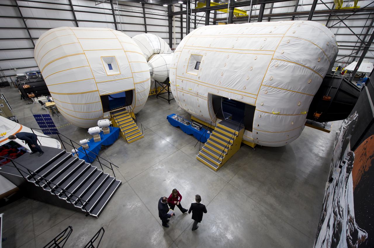
NASA Deputy Administrator Lori Garver is given a tour of the Bigelow Aerospace facilities by the company's President Robert Bigelow on Friday, Feb. 4, 2011, in Las Vegas. NASA has been discussing potential partnership opportunities with Bigelow for its inflatable habitat technologies as part of NASA's goal to develop innovative technologies to ensure that the U.S. remains competitive in future space endeavors. Photo Credit: (NASA/Bill Ingalls)
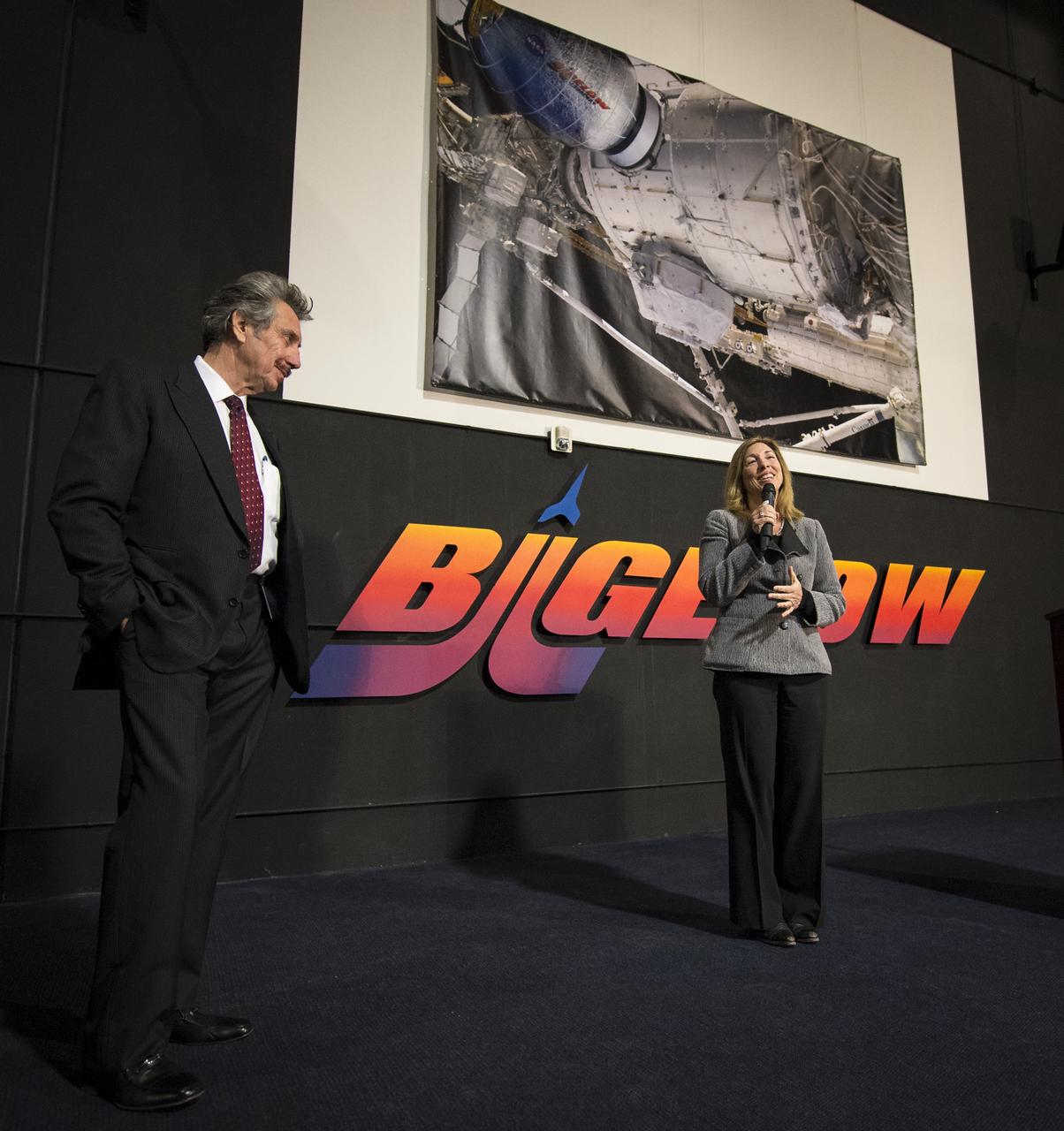
NASA Deputy Administrator Lori Garver and President and founder of Bigelow Aerospace Robert T. Bigelow, announce a planned addition to the International Space Station that will use the orbiting laboratory to test expandable space habitat technology during a press conference held at Bigelow Aerospace on Wednesday, Jan. 16, 2013 in Las Vegas. The $17.8 million contract with Bigelow Aerospace will provide a Bigelow Expandable Activity Module (BEAM), which is scheduled to arrive at the space station in 2015 for a two-year technology demonstration. Photo Credit: (NASA/Bill Ingalls)
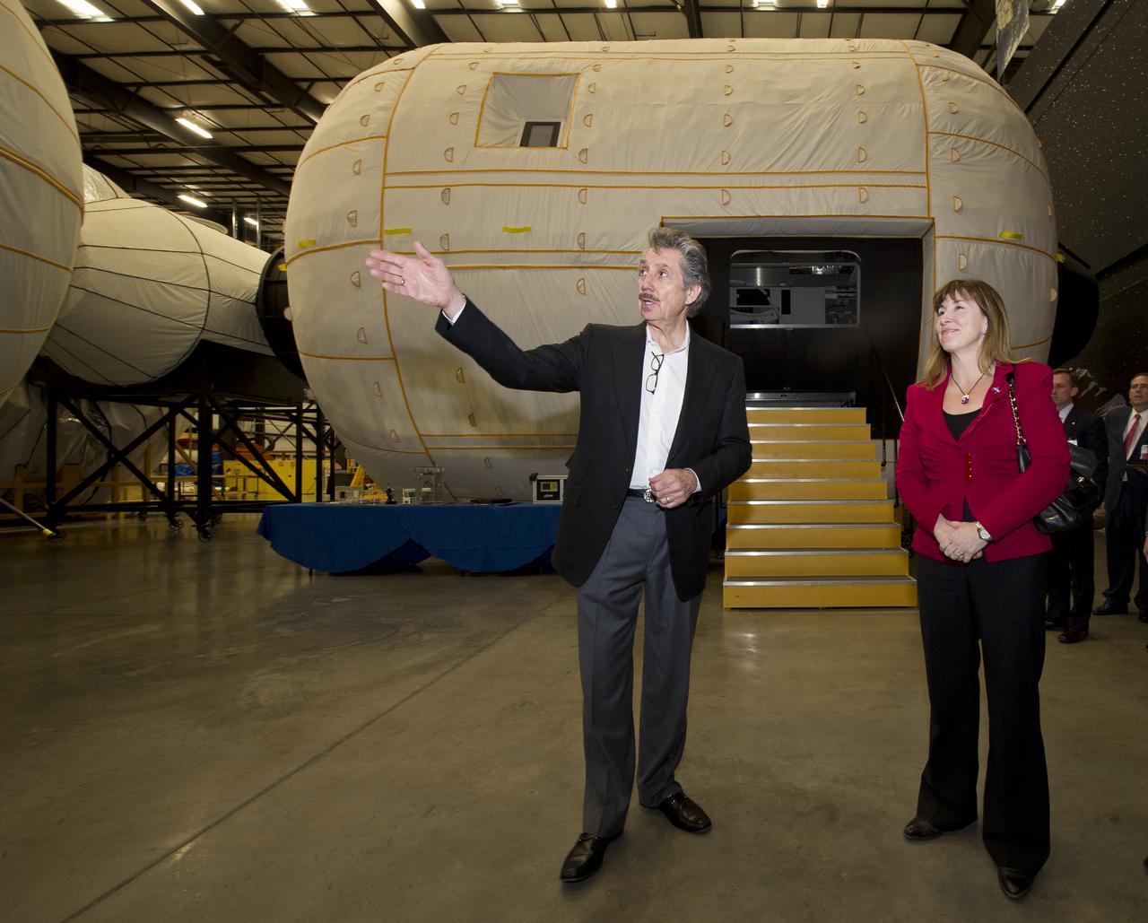
NASA Deputy Administrator Lori Garver is given a tour of the Bigelow Aerospace facilities by the company's President Robert Bigelow on Friday, Feb. 4, 2011, in Las Vegas. NASA has been discussing potential partnership opportunities with Bigelow for its inflatable habitat technologies as part of NASA's goal to develop innovative technologies to ensure that the U.S. remains competitive in future space endeavors. Photo Credit: (NASA/Bill Ingalls)
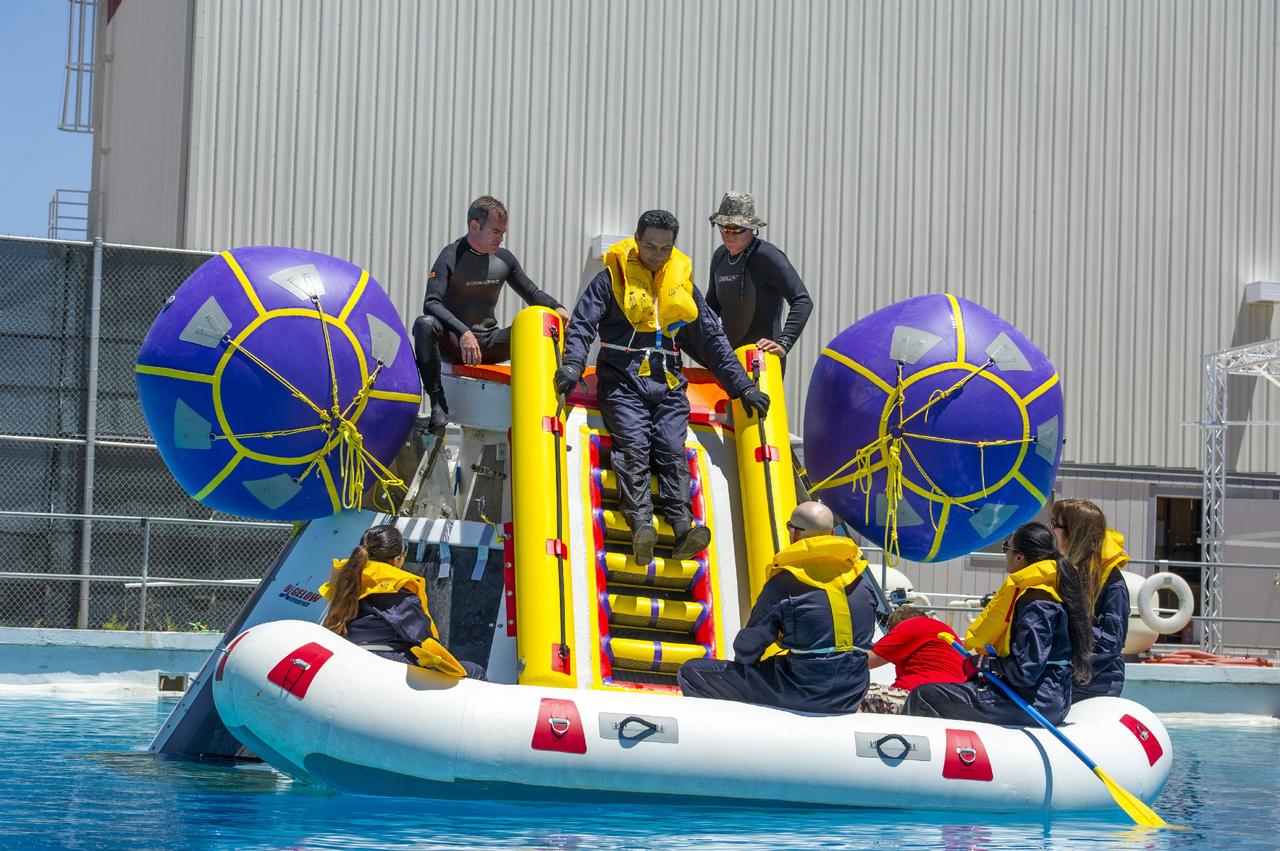
LAS VEGAS, Nev. – The Boeing Company performed simulated contingency water landing scenarios with a mock-up CST-100 spacecraft at Bigelow Aerospace's headquarters near Las Vegas. The CST-100 is designed for ground landings, but could splash down on the water, if necessary. During the water tests, Department of Defense search-and-recovery personnel practiced pulling five Boeing engineers out of the capsule and to safety. The tests are part of the company’s ongoing work supporting its funded Space Act Agreement with NASA’s Commercial Crew Program, or CCP, during the Commercial Crew Integrated Capability, or CCiCap, initiative. CCP is intended to lead to the availability of commercial human spaceflight services for government and commercial customers to low-Earth orbit. Future development and certification initiatives eventually will lead to the availability of human spaceflight services for NASA to send its astronauts to the International Space Station, where critical research is taking place daily. For more information about CCP, go to http://www.nasa.gov/commercialcrew. Photo credit: Boeing
iss073e0075845 (May 16, 2025) --- Las Vegas, Nevada, with a metropolitan population of 2.26 million, and its well-lit strip situated next to Harry Reid International Airport, is pictured at approximately 1:54 a.m. local time from the International Space Station as it orbited 260 miles above.
NASA Deputy Administrator Lori Garver and President and founder of Bigelow Aerospace Robert T. Bigelow talk while standing next to the Bigelow Expandable Activity Module (BEAM) during a media briefing where it is was announced that the BEAM expandable space habitat technology will be tested on the International Space Station, Wednesday, Jan. 16, 2013 in Las Vegas. BEAM is scheduled to arrive at the space station in 2015 for a two-year technology demonstration. Photo Credit: (NASA/Bill Ingalls)
NASA Deputy Administrator Lori Garver and President and founder of Bigelow Aerospace Robert T. Bigelow talk while standing next to the Bigelow Expandable Activity Module (BEAM) during a media briefing where is was announced that the BEAM expandable space habitat technology will be tested on the International Space Station, Wednesday, Jan. 16, 2013 in Las Vegas. BEAM is scheduled to arrive at the space station in 2015 for a two-year technology demonstration. Photo Credit: (NASA/Bill Ingalls)
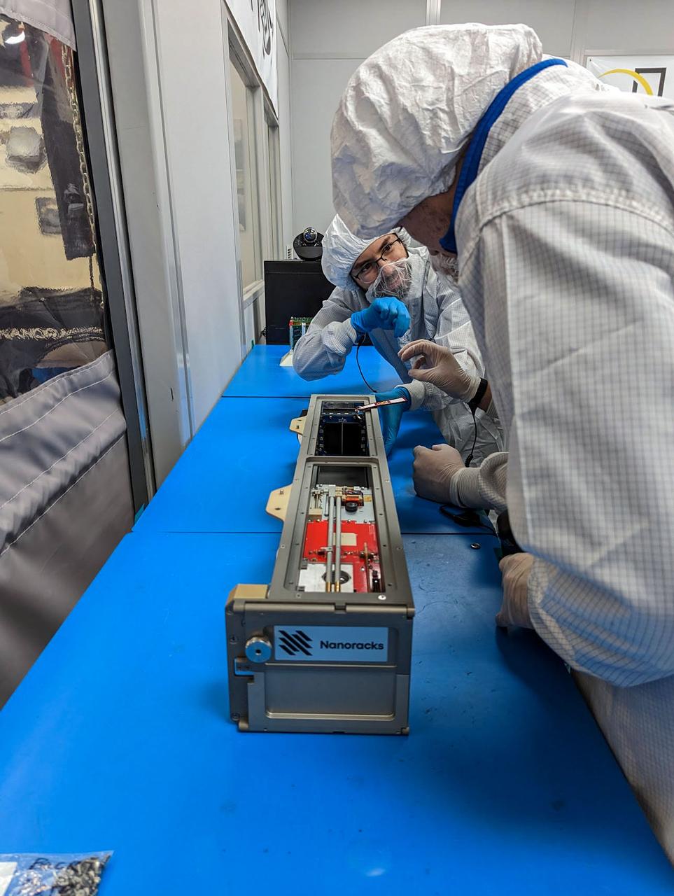
jsc2023e010193 (12/13/2022) --- The LightCube CubeSat is inserted into the Nanoracks CubeSat Deployer by Jaime Sanchez de la Vega and Nanoracks personnel. Image courtesy of Jaime Sanchez de la Vega.

jsc2023e010189 (12/13/2022) --- Lightcube Principal Investigator Jaime Sanchez de la Vega holds the CubeSat prior to integration into the deployer. Image courtesy of Jaime Sanchez de la Vega.
LAS VEGAS -- The Boeing Company tests the forward heat shield FHS jettison system of its CST-100 spacecraft at the Bigelow Aerospace facility in Las Vegas as part of an agreement with NASA's Commercial Crew Program CCP during Commercial Crew Development Round 2 CCDev2) activities. The FHS will protect the spacecraft's parachutes, rendezvous-and-docking sensor packages, and docking mechanism during ascent and re-entry. During a mission to low Earth orbit, the shield will be jettisoned after re-entry heating, allowing the spacecraft's air bags to deploy for a safe landing. In 2011, NASA selected Boeing for CCDev2 to mature the design and development of a crew transportation system with the overall goal of accelerating a United States-led capability to the International Space Station. The goal of CCP is to drive down the cost of space travel as well as open up space to more people than ever before by balancing industry’s own innovative capabilities with NASA's 50 years of human spaceflight experience. Six other aerospace companies also were selected to mature launch vehicle and spacecraft designs under CCDev2, including Alliant Techsystems Inc. ATK, Excalibur Almaz Inc., Blue Origin, Sierra Nevada Corp. SNC, Space Exploration Technologies SpaceX, and United Launch Alliance ULA. For more information, visit www.nasa.gov/commercialcrew. Image credit: Boeing The Ground Systems Development and Operations Program is developing the necessary ground systems, infrastructure and operational approaches required to safely process, assemble, transport and launch the next generation of rockets and spacecraft in support of NASA’s exploration objectives. Future work also will replace the antiquated communications, power and vehicle access resources with modern efficient systems. Some of the utilities and systems slated for replacement have been used since the VAB opened in 1965. For more information, visit http://www.nasa.gov/exploration/systems/ground/index.html Photo credit: Boeing
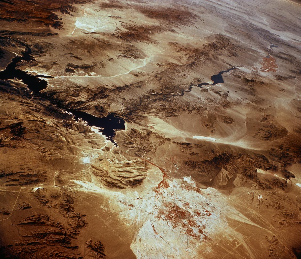
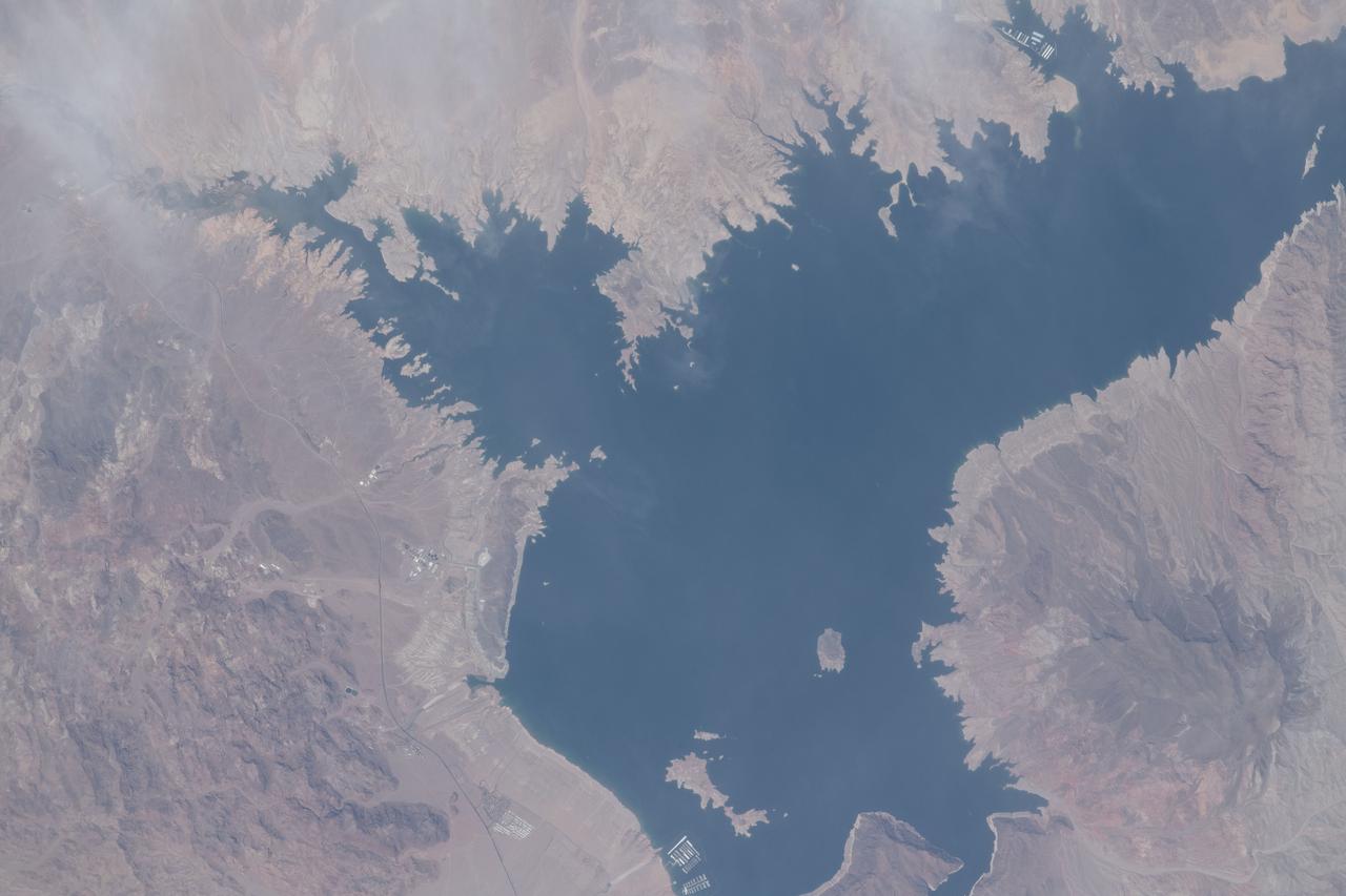
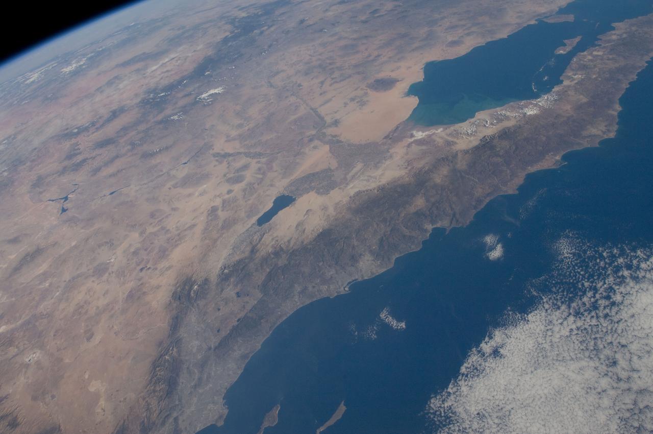
SL3-28-059 (July-September 1973) --- A vertical view of the Lake Mead and Las Vegas, Nevada area as photographed from Earth orbit by one of the six lenses of the Itek-furnished S190-A Multispectral Photographic Facility Experiment aboard the Skylab space station. Lake Mead is water of the Colorado River impounded by Hoover Dam. Most of the land in the picture is Nevada. However, a part of the northwest corner of Arizona can be seen. Federal agencies participating with NASA on the EREP project are the Departments of Agriculture, Commerce, Interior, the Environmental Protection Agency and the Corps of Engineers. All EREP photography is available to the public through the Department of Interior?s Earth Resources Observations Systems Data Center, Sioux Falls, South Dakota, 57198. Photo credit: NASA
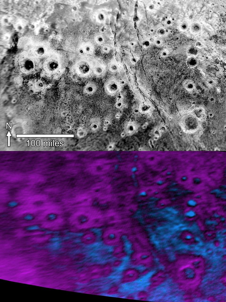
Within Pluto informally named Vega Terra region is a field of eye-catching craters that looks like a cluster of bright halos scattered across a dark landscape as seen by NASA New Horizons.
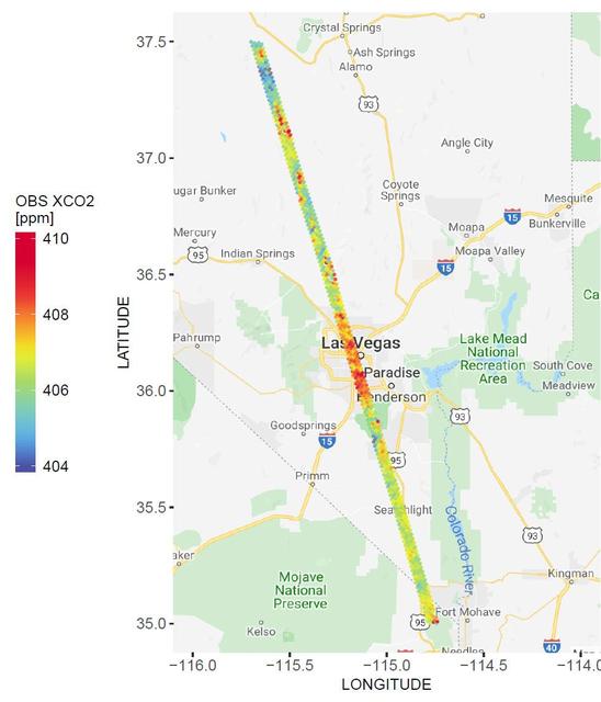
A spatial map of the amount of carbon dioxide (CO2) present in columns of the atmosphere below NASA's Orbiting Carbon Observatory-2 (OCO-2) satellite as it flew over Las Vegas on Feb. 8, 2018. Warmer colors over the city center indicate higher amounts of carbon dioxide. https://photojournal.jpl.nasa.gov/catalog/PIA23781
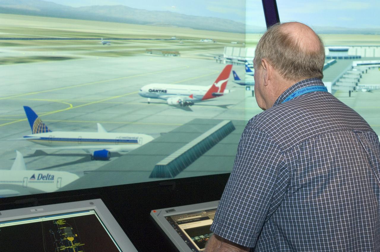
IVAAAN Simulation project (Ivanpah Valley Airfield Alternative Analysis: Las Vegas) @ Ames FFC Simulator facility with Howard Smith
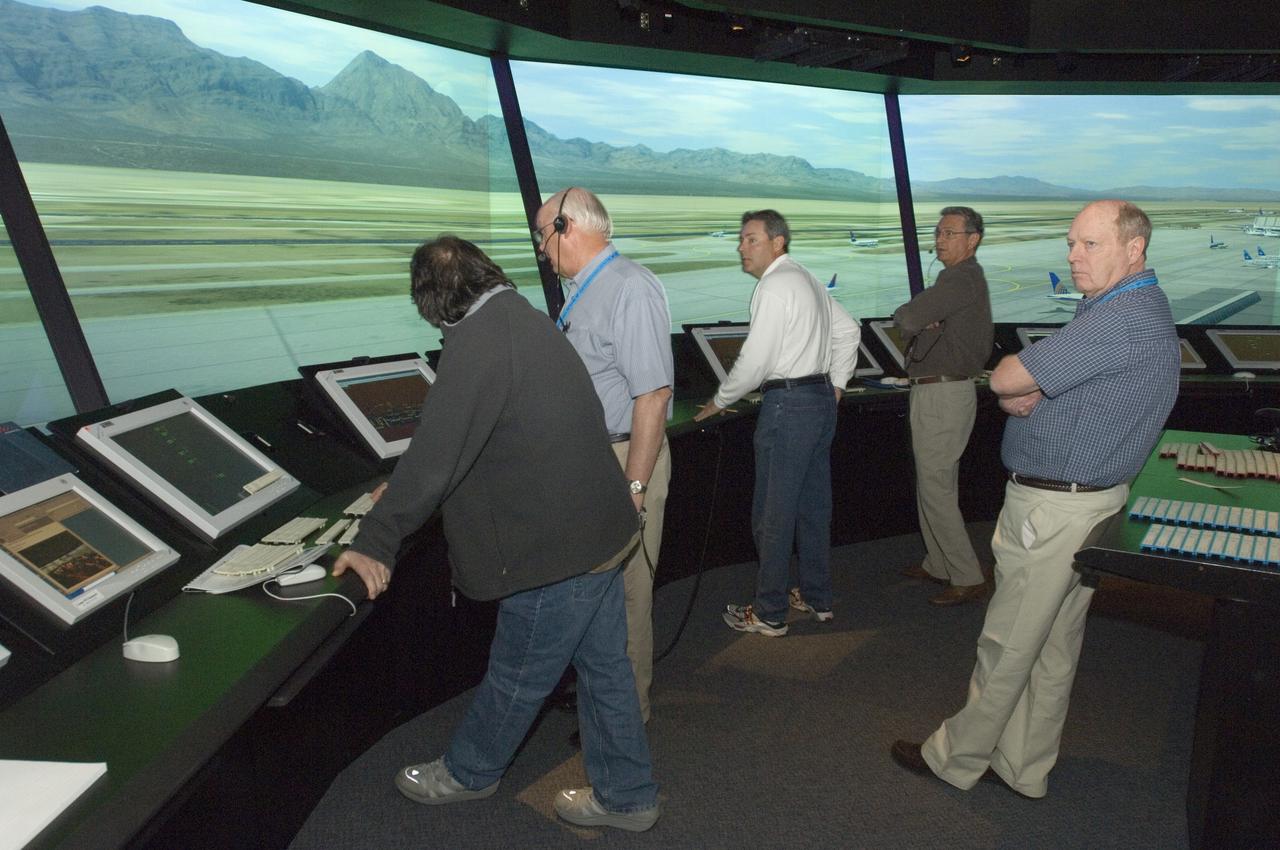
IVAAAN Simulation project (Ivanpah Valley Airfield Alternative Analysis: Las Vegas) @ Ames FFC Simulator facility
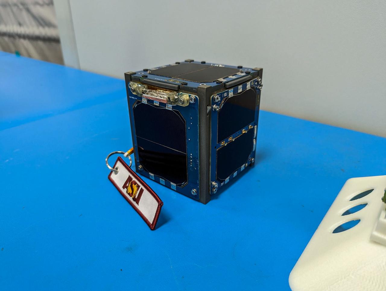
jsc2023e010192 (12/13/2022) --- LightCube CubeSat awaits integration. Image courtesy of Jaime Sanchez de la Vega.
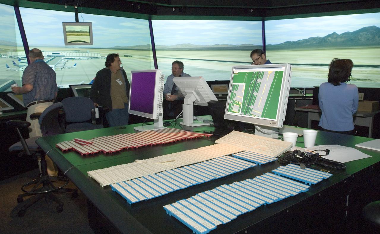
IVAAAN Simulation project (Ivanpah Valley Airfield Alternative Analysis: Las Vegas) @ Ames FFC Simulator facility
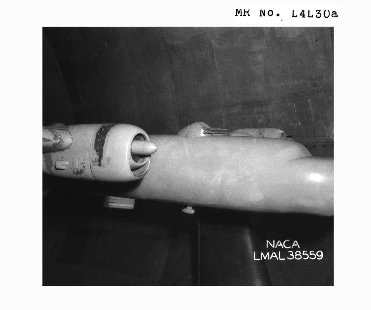
Detail Shots of B-32 Turret. B-33 Vega Turrets. Test conducted in the NACA 19 foot pressure tunnel LMAL-38560 NACA document.
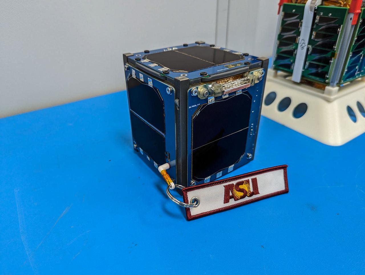
jsc2023e010191 (12/13/2022) --- LightCube CubeSat (foreground) and ARKSat-1 (background) await integration. Image courtesy of Jaime Sanchez de la Vega.
iss065e001327 (April 20, 2021) --- The Colorado River, pictured from the International Space Station at an altitude of 263 miles, separates Arizona from Nevada. The smaller body of water at center left is Las Vegas Bay.
iss056e032756 (June 20, 2018) --- From left to right (true orientation is from south to north along Interstate 15) in this photograph are McCarran International Airport and downtown Las Vegas, Nev.
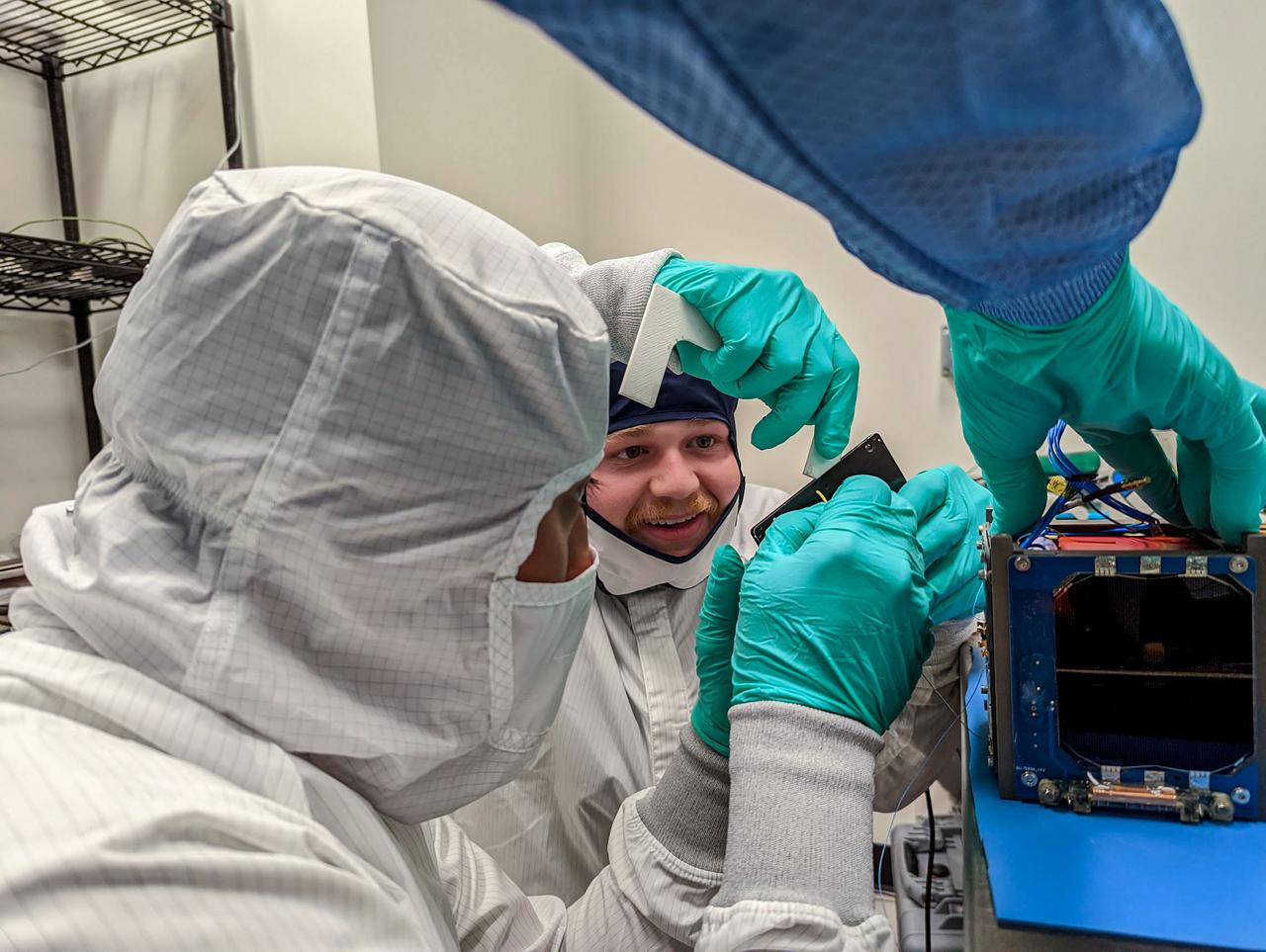
jsc2023e010186 (12/13/2022) --- Professor Danny Jacobs inspects the LightCube inside the Random Vibration Test Fixture. Image courtesy of Jaime Sanchez de la Vega.
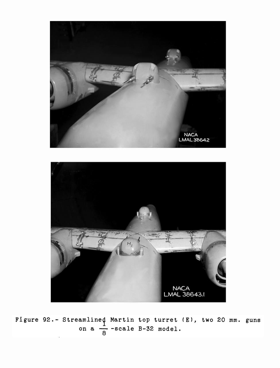
Gun Turrets of XP-35 Figure 92 Streamlined Martin Top Turret. B-33 Vega Turrets. Test conducted in the NACA 19 foot pressure tunnel LMAL-38560 NACA document.
jsc2023e010194 (12/13/2022) --- A pair of students install a solar array panel during the flight assembly of LightCube. From left to right: David Ordaz Perez and Chandler Hutchens. Image courtesy of Jaime Sanchez de la Vega.
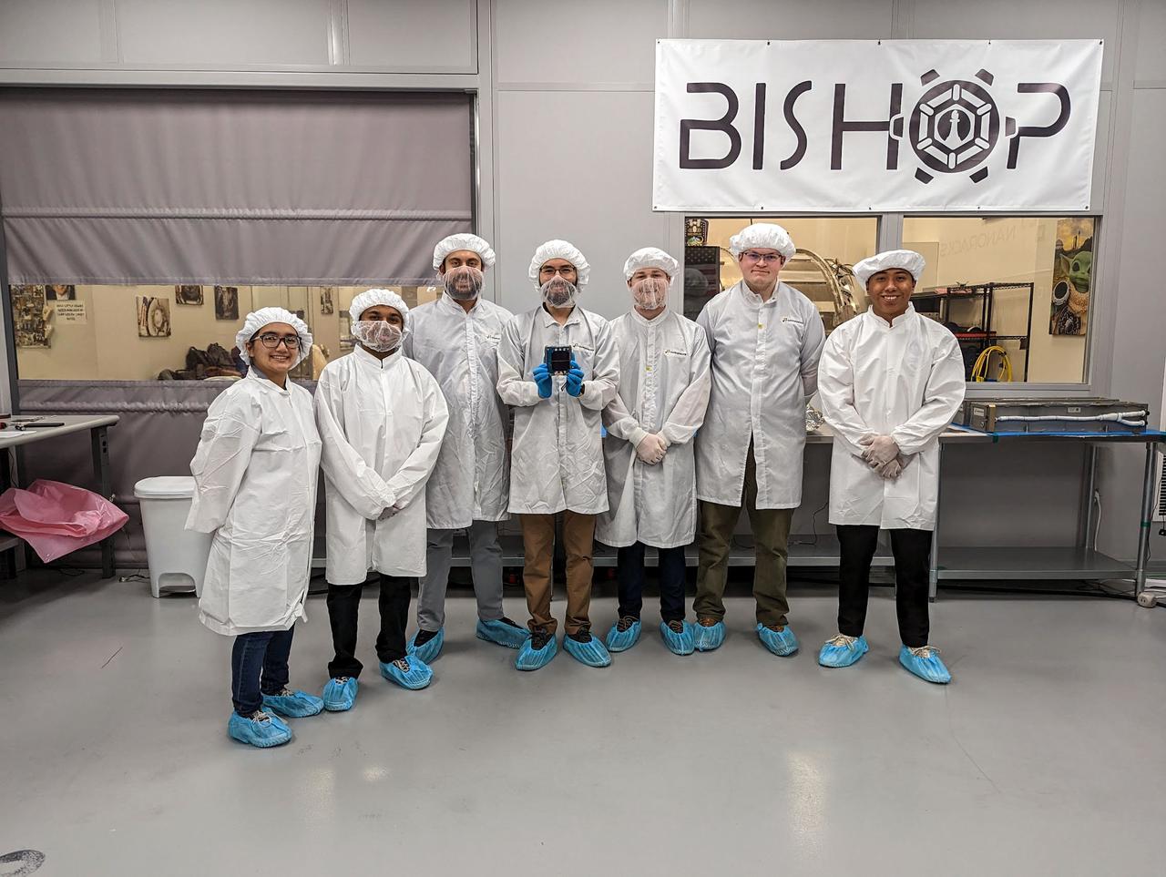
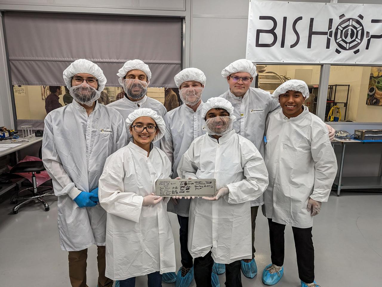
jsc2023e010187 (12/13/2022) --- LightCube team members with their CubeSat on integration day. From back to left to right: Ashley Lepham, Sam Cherian, Raymond Barakat, Jaime Sanchez de la Vega, Chandler Hutchens, Christopher McCormick, David Ordaz Perez. Image courtesy of Sam Cherian.
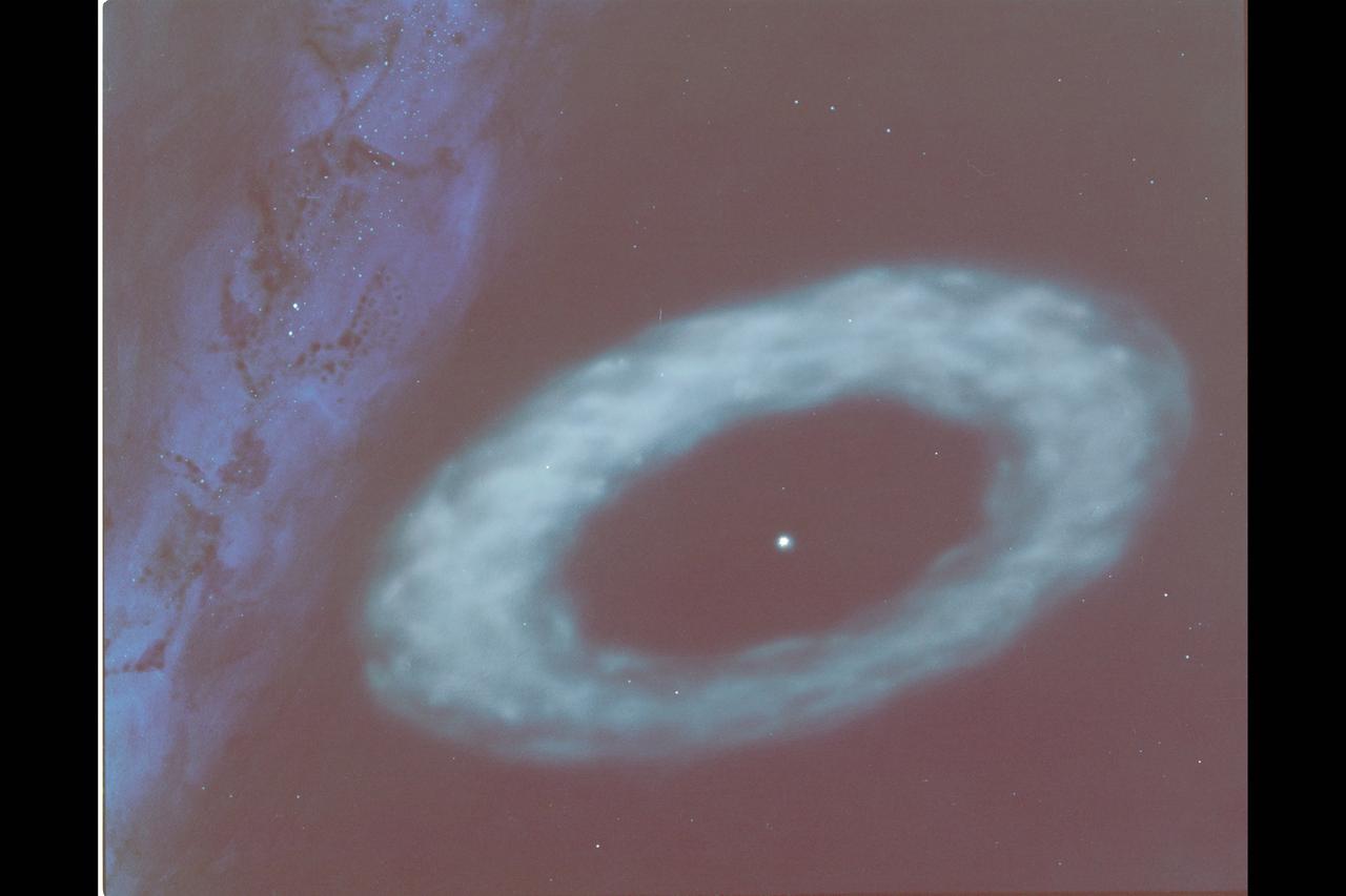
This artist's concept illustrates the ring of material discovered by the Infrared Astronomical Satellite around the star Vega. IRAS scientists believe the material probably consists of dust and small objects resembling meteors. As depicted here, the ring of particles is thin enough toallow light from distant stars to shine through. The plane of the Milky Way is to the right.
iss070e091729 (Feb. 11, 2024) --- The International Space Station was soaring 261 miles above Las Vegas at the time of this photograph minutes before kickoff at Super Bowl LVIII on Feb. 11, 2024. Landmarks pictured from an external station camera are, Allegiant Stadium, The Sphere (partially obscured by shadow), and Harry Reid International Airport.
jsc2023e010185 (12/13/2022) --- Pair of students install a solar array panel during the flight assembly of LightCube. From left to right: David Ordaz Perez and Chandler Hutchens. Image courtesy of Jaime Sanchez de la Vega.
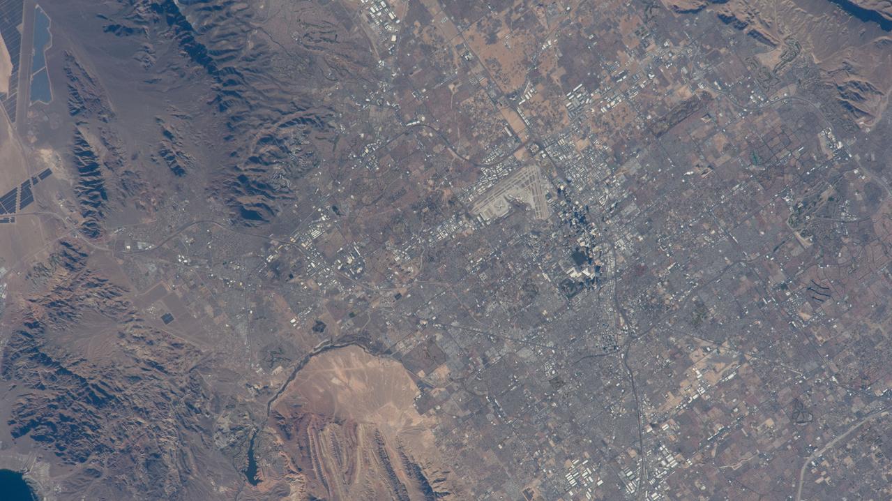
ISS040-E-104966 (23 Aug. 2014) --- One of the Expedition 40 crew members aboard the International Space Station used an 800mm focal length to photograph this detailed image featuring a nadir view of the Las Vegas "Strip" and McCarron International Airport on Aug. 23, 2014.
jsc2023e010190 (12/13/2022) --- LightCube team members inspect the CubeSat prior to integration into the deployer. From left to right: David Ordaz Perez, Chandler Hutchens, Sam Cherian, Christopher McCormick, Ashley Lepham, Raymond Barakat. Image courtesy of Jaime Sanchez de la Vega.
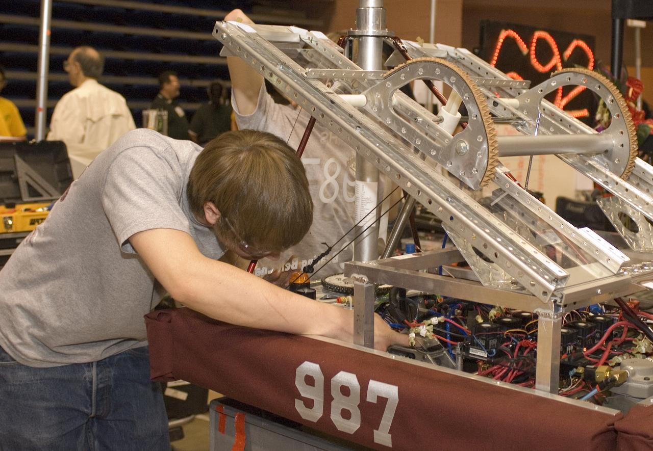
Silicon Valley FIRST Regional Robotics competition: HIGHROLLERS - TEAM 987 - Bearing Belt Chain/Alcoa Fastening Systems/VSR Lock/NASA/Summerlin Children's Forum & Cimarron-Memorial High School, Las Vegas, Nevada (NV)

Kevin Vega, Commercial Crew Program Chief Engineer, monitors the countdown during a dress rehearsal in preparation for the launch of a SpaceX Falcon 9 rocket carrying the company's Dragon spacecraft on NASA’s SpaceX Crew-11 mission with NASA astronauts Zena Cardman, Mike Fincke, JAXA (Japan Aerospace Exploration Agency) astronaut Kimiya Yui, and Roscosmos cosmonaut Oleg Platonov onboard, Monday, July 28, 2025, in the control room of SpaceX’s HangerX at NASA’s Kennedy Space Center in Florida. NASA’s SpaceX Crew-11 mission is the eleventh crew rotation mission of the SpaceX Dragon spacecraft and Falcon 9 rocket to the International Space Station as part of the agency’s Commercial Crew Program. Cardman, Fincke, Yui, Platonov are scheduled to launch on 12:09 p.m. EDT on Thursday, July 31, from Launch Complex 39A at the NASA's Kennedy Space Center. Photo Credit: (NASA/Joel Kowsky)

Jeremy Hart, Integrated Performance Chief Engineer for NASA's Commercial Crew Program, center, speaks with Nicole Jordan, NASA operations manager for the Commercial Crew Program, left, and Kevin Vega, Commercial Crew Program Chief Engineer, as teams monitor the countdown of a launch attempt of a SpaceX Falcon 9 rocket carrying the company's Dragon spacecraft on NASA’s SpaceX Crew-11 mission with NASA astronauts Zena Cardman, Mike Fincke, JAXA (Japan Aerospace Exploration Agency) astronaut Kimiya Yui, and Roscosmos cosmonaut Oleg Platonov onboard, Thursday, July 31, 2025, in the control center of SpaceX’s HangarX at NASA’s Kennedy Space Center in Florida. NASA’s SpaceX Crew-11 mission is the eleventh crew rotation mission of the SpaceX Dragon spacecraft and Falcon 9 rocket to the International Space Station as part of the agency’s Commercial Crew Program. Today’s launch of Cardman, Fincke, Yui, Platonov was scrubbed due to weather and is now scheduled for 11:43 a.m. EDT on Friday, August 1, from Launch Complex 39A at the NASA's Kennedy Space Center. Photo Credit: (NASA/Joel Kowsky)
ISS035-E-027434 (23 April 2013) --- One of the Expedition 35 crew members aboard the Earth-orbiting International Space Station recorded this widespread image covering parts of Mexico, California and Nevada: Grand Canyon to Lake Mead and Las Vegas area (lower right corner), and westward to include the Gulf of California (beneath the docked Russian vehicle at upper left), the Salton Sea, Los Angeles Basin, and Great Valley.
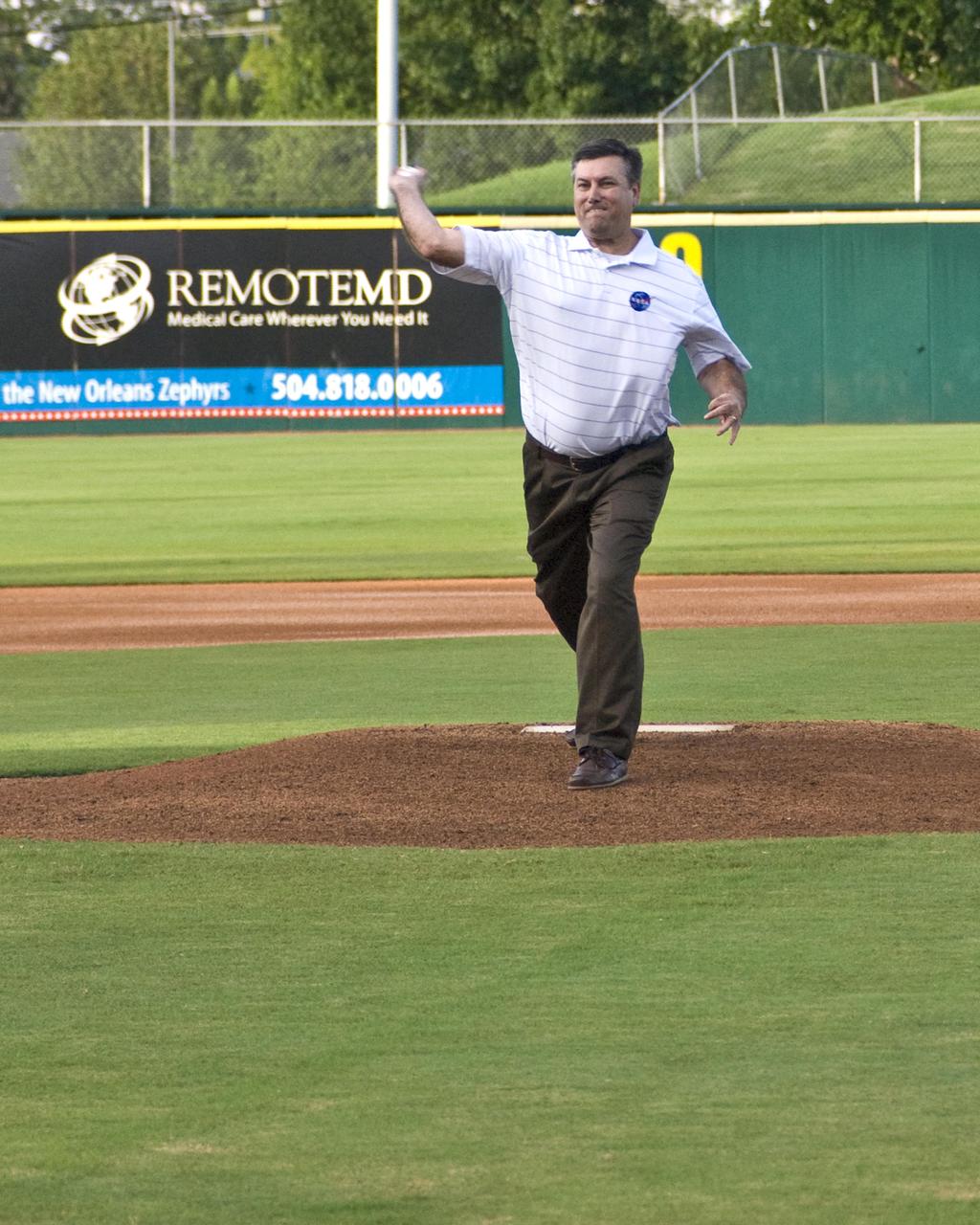
NASA's John C. Stennis Space Center Director Patrick Scheuermann throws the first pitch of the game Aug. 20 at New Orleans Zephyr Field. Stennis employees traveled to New Orleans to host NASA Night at Zephyr Field. Stennis personnel provided a variety of activities and materials for persons attending a game between the New Orleans Zephyrs and the Las Vegas 51s.
STS090-756-046 (17 April - 3 May 1998) --- A 70mm view of the Las Vegas, Nevada area, including the western-most tip of Lake Mead. The flight track of the Space Shuttle Columbia and lack of heavy cloud cover during the 16-day Neurolab mission allowed the astronauts a number of opportunities to photograph North American cities.
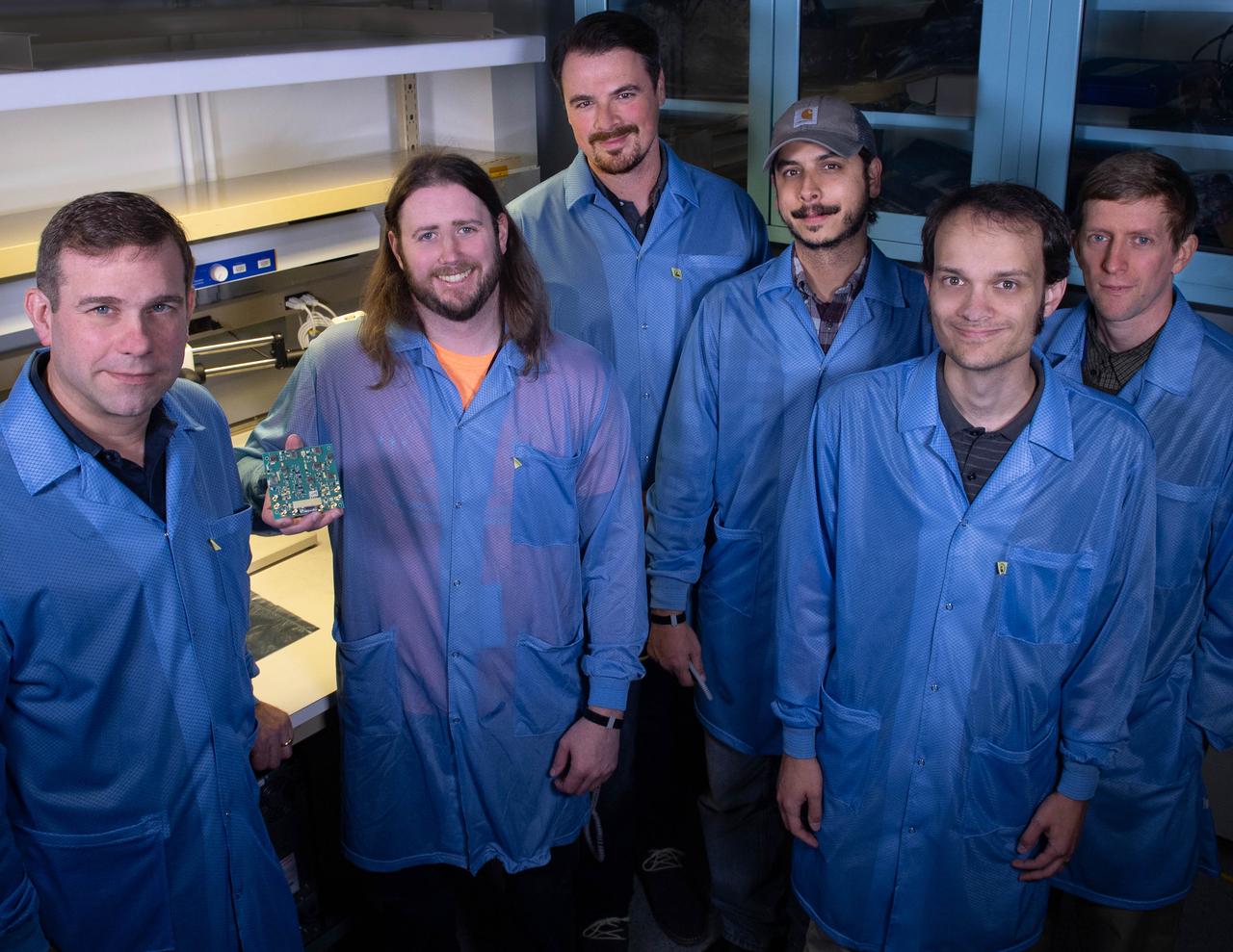
Several Goddard technologists are involved in a new CubeSat technology-demonstration mission called SNoOPI, which employs a novel remote-sensing technique for measuring soil-moisture levels. From left to right: Jeffrey Piepmeier, Chase Kielbasa, who is holding a first-generation prototype circuit board for the SNoOPI instrument, Joseph Knuble, Manuel Vega, Michael Coon, and Derek Hudson.
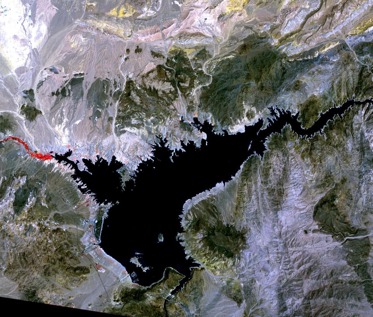
Lake Mead, the largest reservoir in the US, has fallen to its lowest level ever. The water is a major source for such cities as Los Angeles and Las Vegas. With the predicted drought through this summer, the lake's water supply is expected to further shrink. In 2000, the lake was at its highest, and has declined ever since. The images were acquired June 14, 2021 and July 6, 2000, cover an area of 25.5 by 30 km, and are located at 36 degrees north, 114.7 degrees west. https://photojournal.jpl.nasa.gov/catalog/PIA24696
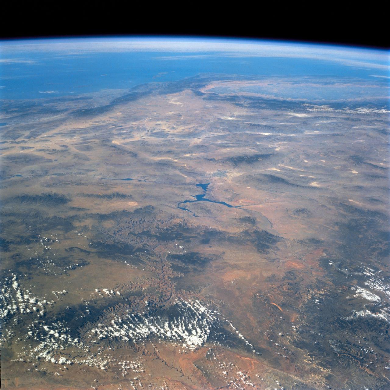
STS058-74-000R (18 Oct-1 Nov 1993) --- A broad view westward along the Colorado River from just below Glen Canyon Dam (out of picture), through the entire Grand Canyon to Lake Mead and Las Vegas, and westward to include southern Nevada and much of California. The Salton Sea, Los Angeles Basin, and Great Valley rim the Pacific Coast in the distance. Photo credit: NASA
A white plate on the top of the wing of a restored National Advisory Committee for Aeronautics (NACA) P-51D Mustang mounts scale airfoil shapes as used by the NACA in the late 1940s for high-speed research. This former NACA testbed Mustang was rebuilt by John Muszala for Bill Allmon of Las Vegas, Nevada, who has been flying it since 1998. Allmon flew the vintage fighter to NASA's Dryden Flight Research Center at Edwards, California, Sept. 15, 2000 for a reunion of former NACA employees.
jsc2023e010188 (12/13/2022) --- LightCube team holds a signed Nanoracks CubeSat Deployer panel following integration of the LightCube CubeSat. From back to front and from left to right: Jaime Sanchez de la Vega, Raymond Barakat, Chandler Hutchens, Christopher McCormick, David Ordaz Perez, Ashley Lepham, Sam Cherian. Image courtesy of Sam Cherian.

Stennis employee Chris Smith helps a young child 'launch' a balloon rocket. Employees from NASA's John C. Stennis Space Center traveled to New Orleans on Aug. 20 to host NASA Night at Zephyr Field. Stennis personnel provided a variety of activities and materials for persons attending a game between the New Orleans Zephyrs and the Las Vegas 51s.
Stennis employee Chris Smith helps a young child 'launch' a balloon rocket. Employees from NASA's John C. Stennis Space Center traveled to New Orleans on Aug. 20 to host NASA Night at Zephyr Field. Stennis personnel provided a variety of activities and materials for persons attending a game between the New Orleans Zephyrs and the Las Vegas 51s.

ISS026-E-006255 (30 Nov. 2010) --- This night time image, photographed by an Expedition 26 crew member on the International Space Station, features the Las Vegas, Nevada metropolitan area, located near the southern tip of the state within the Mohave Desert of the southwestern USA. While the city of Las Vegas proper is famous for its casinos and resort hotels – the city bills itself as “the entertainment capital of the world” – the metropolitan area includes several other incorporated cities and unincorporated (not part of a state-recognized municipality) areas. Crew members onboard the ISS observe and photograph numerous metropolitan sites when the areas are illuminated by sunlight, but the extent and pattern of these areas are perhaps best revealed by the city lights at night. The surrounding dark desert presents a stark contrast to the brightly lit, regular street grid of the developed metropolitan area. The Vegas Strip (center) is reputed to be the brightest spot on Earth due to the concentration of lights associated with its hotels and casinos. The tarmac of McCarran International Airport to the south is a dark feature by comparison. The airstrips of Nellis Air Force Base on the northeastern fringe of the metropolitan area are likewise dark compared to the well-lit adjacent streets and neighborhoods. The dark mass of Frenchman Mountain borders the metropolitan area to the east. Acquisition of focused night time images such as this one requires space station crew members to track the target with the handheld camera while the ISS is moving at a speed of more than seven kilometers per second (15,659 miles per hour) relative to Earth’s surface. This was achieved during ISS Expedition Six using a homemade tracking device, but subsequent crews have needed to develop manual tracking skills. These skills, together with advances in digital camera technology, have enabled recent ISS crews to acquire striking night time images of Earth.
ISS029-E-042846 (16 Nov. 2011) --- Parts of the U.S. and Mexico are seen in this image photographed by one of the Expedition 29 crew members from the International Space Station as it flew above the Pacific Ocean on Nov. 16, 2011. The Salton Sea is in the center of the frame, with the Gulf of Cortez, Mexico's Baja California and the Colorado River in the upper right quadrant. The Los Angeles Basin and Santa Catalina and San Clemente islands are at the bottom center edge of the image. Lake Mead and the Las Vegas area of Nevada even made it into the frame in the upper left quadrant.
SL2-03-192 (22 June 1973) --- Lake Mead, Nevada, (36.0N, 114.5E) where the water from the Colorado River empties after it's 273 mile journey through the Grand Canyon of Arizona is the subject of this photo. Other features of interest are Hoover Dam on the south shore of Lake Mead where cheap hydroelectric power is secondary to the water resources made available in this northern desert region and the resort city of Las Vegas, just to the west of Lake Mead. In this harsh desert environment, color infrared photography readily penetrates haze, detects and portrays vegetation as shades of red. Photo credit: NASA
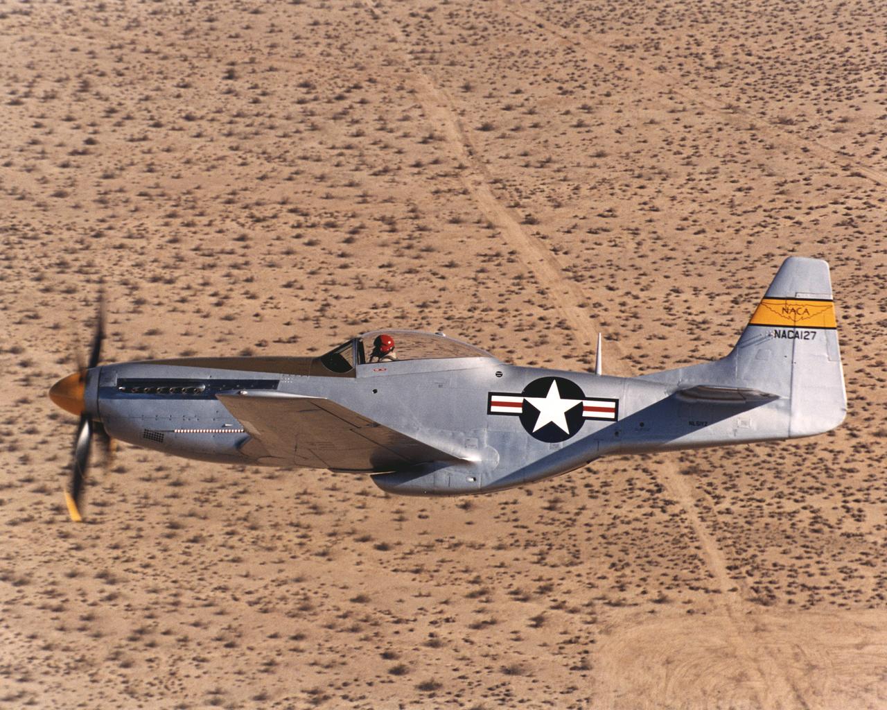
Bill Allmon of Las Vegas, Nevada, brought his restored NACA P-51D to a reunion of former NACA employees at the NASA Dryden Flight Research Center located at Edwards Air Force Base, Calif., on Sept. 15, 2000. Allmon's award-winning restoration is a genuine former NACA testbed that saw service at the Langley Research Center in Virginia in the late 1940s. Later this Mustang was put on outdoor static display as an Air National Guard monument in Pittsburgh, Pa., where exposure to the elements ravaged its metal structure, necessitating an extensive four-year rebuild.
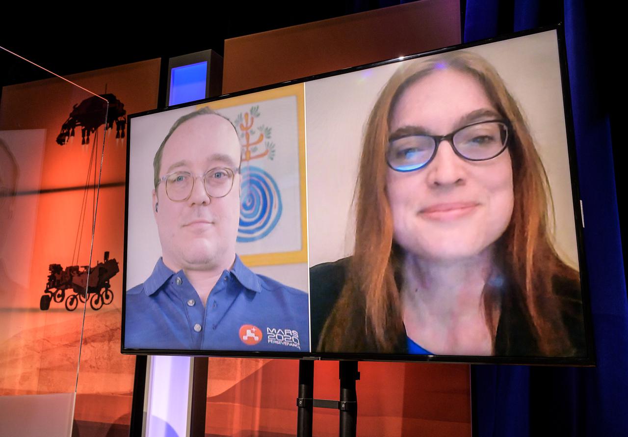
Perseverance deputy project scientist, JPL, Ken Williford, screen left, and Participating scientist for returned sample science, University of Nevada Las Vegas, Libby Hausrath, give remarks via remote during a NASA Perseverance rover press briefing about the search for ancient life at Mars and about samples to be brought back to Earth on a future mission, Wednesday, Feb. 17, 2021, at NASA's Jet Propulsion Laboratory in Pasadena, California. The Perseverance Mars rover is due to land on Mars Thursday, Feb. 18, 2021. A key objective for Perseverance’s mission on Mars is astrobiology, including the search for signs of ancient microbial life. The rover will characterize the planet’s geology and past climate, pave the way for human exploration of the Red Planet, and be the first mission to collect and cache Martian rock and regolith. Photo Credit: (NASA/Bill Ingalls)
STS068-267-097 (30 September-11 October 1994) --- An extensive view eastward from the irrigated San Joaquin Valley in the foreground, across the Sierra Nevada (living up to its name in early October), into the desert of eastern California and Nevada (which has no snow, despite the name). Mono Lake is just visible at the left edge of the frame; Owens Valley extends southward to Owens Lake, the next valley is Panamint Valley, and then Death Valley. Las Vegas and Lake Mead are visible at the upper right of the frame. The Space Radar Laboratory 2 (SRL-2) obtained extensive, multiple-pass data from many test sites within the region displayed, including Mammoth Mountain ski area south of Mono Lake, and in Death Valley.
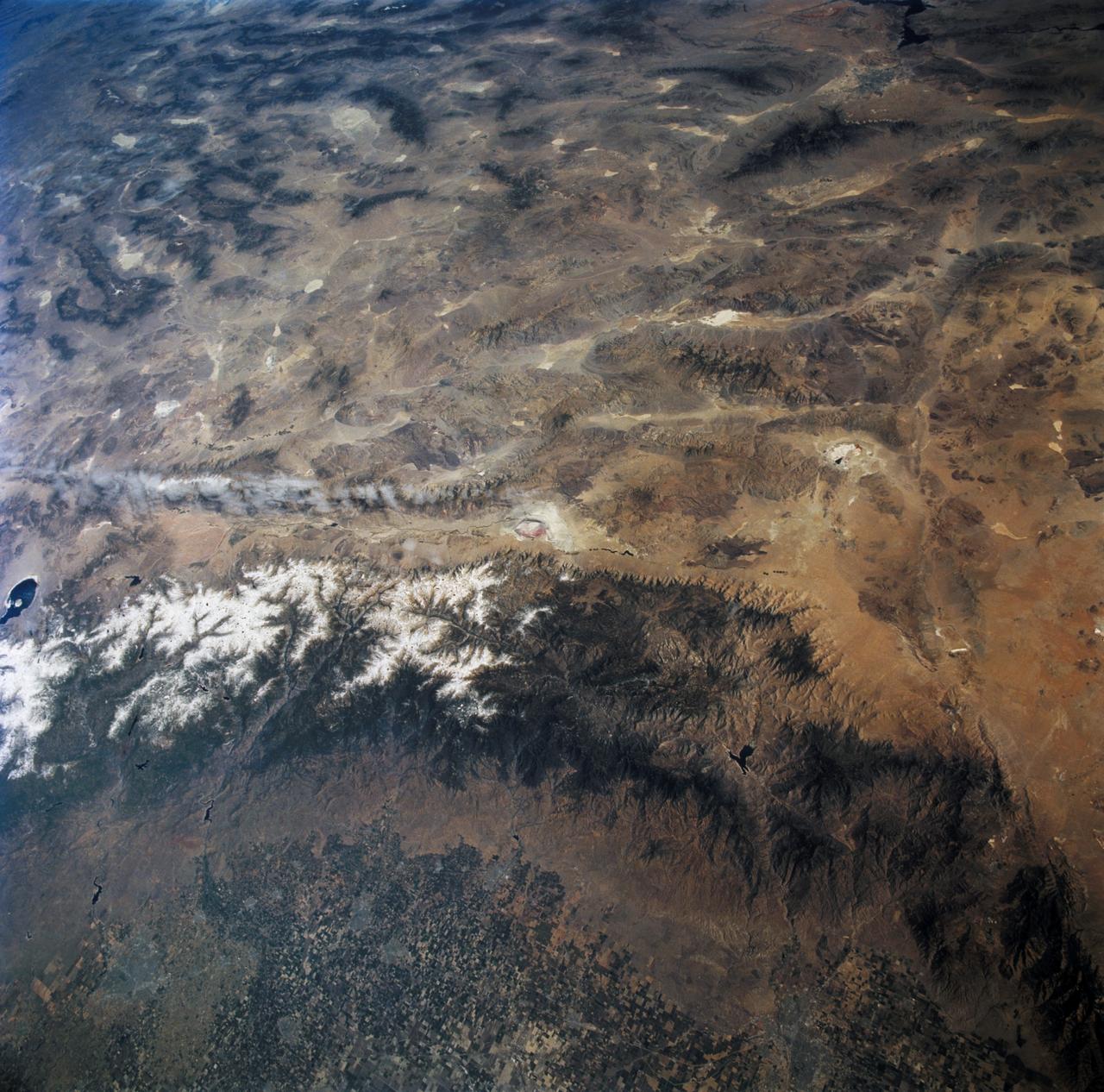
ISS024-E-014071 (9 Sept. 2010) --- This striking panoramic view of the southwestern USA and Pacific Ocean is an oblique image photographed by an Expedition 24 crew member looking outwards at an angle from the International Space Station (ISS). While most unmanned orbital satellites view Earth from a nadir perspective?in other words, collecting data with a ?straight down? viewing geometry?crew members onboard the space station can acquire imagery at a wide range of viewing angles using handheld digital cameras. The ISS nadir point (the point on Earth?s surface directly below the spacecraft) was located in northwestern Arizona, approximately 260 kilometers to the east-southeast, when this image was taken. The image includes parts of the States of Arizona, Nevada, Utah, and California together with a small segment of the Baja California, Mexico coastline at center left. Several landmarks and physiographic features are readily visible. The Las Vegas, NV metropolitan area appears as a gray region adjacent to the Spring Mountains and Sheep Range (both covered by white clouds). The Grand Canyon, located on the Colorado Plateau in Arizona, is visible (lower left) to the east of Las Vegas with the blue waters of Lake Mead in between. The image also includes the Mojave Desert, stretching north from the Salton Sea (left) to the Sierra Nevada mountain range. The Sierra Nevada range is roughly 640 kilometers long (north-south) and forms the boundary between the Central Valley of California and the adjacent Basin and Range. The Basin and Range is so called due to the pattern of long linear valleys separated by parallel linear mountain ranges ? this landscape, formed by extension and thinning of Earth?s crust, is particularly visible at right.
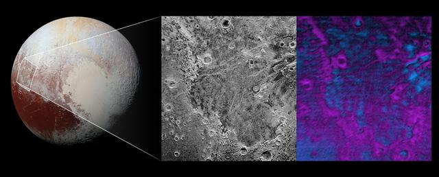
Scientists on NASA's New Horizons mission have discovered what looks like a giant bite-mark on the planet's surface. In this image, north is up. The southern portion of the left inset above shows the cratered plateau uplands informally named Vega Terra (note that all feature names are informal). This terrain is separated from the young, nearly uncratered, mottled plains of Piri Planitia in the center of the image by a generally north-facing jagged scarp called Piri Rupes. The scarp breaks up into isolated mesas in several places. Cutting diagonally across Piri Planitia is the long extensional fault of Inanna Fossa, which stretches eastward 370 miles (600 kilometers) from here to the western edge of the great nitrogen ice plains of Sputnik Planum. Compositional data from the New Horizons spacecraft's Ralph/Linear Etalon Imaging Spectral Array (LEISA) instrument, shown in the right inset, indicate that the plateau uplands south of Piri Rupes are rich in methane ice (shown in false color as purple). Scientists speculate that sublimation of methane may be causing the plateau material to erode along the face of the scarp cliffs, causing them to retreat south and leave the plains of Piri Planitia in their wake. Compositional data also show that the surface of Piri Planitia is more enriched in water ice (shown in false color as blue) than the plateau uplands, which may indicate that Piri Planitia's surface is made of water ice bedrock, on top of which the layer of retreating methane ice had been sitting. Because the surface of Pluto is so cold, the water ice behaves like rock and is immobile. The light/dark mottled pattern of Piri Planitia in the left inset is reflected in the composition map, with the lighter areas corresponding to areas richer in methane – these may be remnants of methane that have not yet sublimated away entirely. The inset at left shows about 650 feet (200 meters) per pixel; the image measures approximately 280 miles (450 kilometers) long by 255 miles (410 kilometers) wide. It was obtained by New Horizons at a range of approximately 21,100 miles (33,900 kilometers) from Pluto, about 45 minutes before the spacecraft's closest approach to Pluto on July 14, 2015.The LEISA data at right was gathered when the spacecraft was about 29,000 miles (47,000 kilometers) from Pluto; best resolution is 1.7 miles (2.7 kilometers) per pixel. http://photojournal.jpl.nasa.gov/catalog/PIA20531
NASA astronauts Stephanie Wilson and Victor Glover pose with recipients of the Silver Snoopy award after the ceremony on Thursday, Oct. 17, at the Kennedy Space Center Visitor Complex in Florida. From left to right, those photographed include Wilson; Marcos Otero-Cruz, Defense Contract Management Agency; Mark Burton, Jacobs Technology; Kevin Vega, NASA Engineering; John Posey, NASA Engineering; Miles Ashley, NASA Engineering; Jamie Szafran, NASA Engineering; Paul Kuracz, NASA Engineering; Wilson Zheng, Jacobs Technology; Mark Dykstra, Defense Contract Management Agency; Elizabeth Cook, Safety and Mission Assurance; Dean Kendall, Jacobs Technology; Connie Lehan, NASA Engineering; Paul Janes, Jacobs Technology; Glover; and in front, Salim Nasser, NASA Engineering. The Silver Snoopy is part of NASA’s Space Flight Awareness Program, which recognizes outstanding job performances and contributions by civil servants and contract employees. It focuses on excellence in quality and safety in support of human spaceflight.
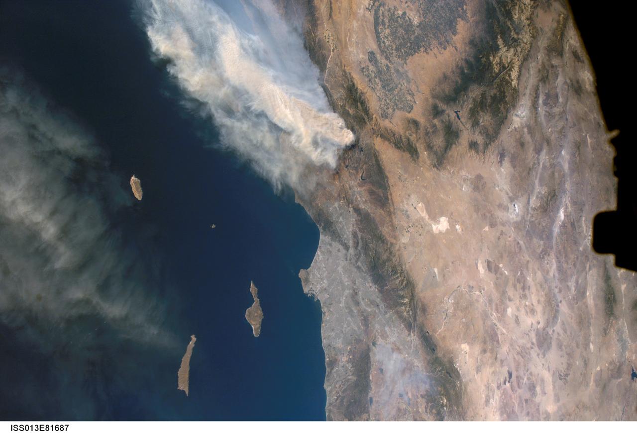
ISS013-E-81687 (17 Sept. 2006) --- A forest fire in southern California is featured in this image photographed by an Expedition 13 crewmember on the International Space Station. The day fire started in Los Padres National Forest north of Los Angeles on Sept. 4, 2006. Easterly winds on Sept. 17 blew the smoke west out to sea, and this wind shift was observed by station crewmembers. The forested mountains north of Los Angeles appear dark green, the smoke a dusky gray. Dense farmland at the south end of California's central valley is framed by the forested Sierra Nevada mountain range. White patches near the center of the view are dry lakes of the Mojave Desert, one of which acts as a landing site for the space shuttle. The dark irregular shape at image right is part of the space station. Death Valley and Las Vegas are visible at image right. The extent of the day fire smoke plume can be gauged from the gray urban region of greater Los Angeles (center) which stretches along 50 miles of coastline. The plume obscures the northern Channel Islands, but the southern Channel Islands are silhouetted against the ocean.
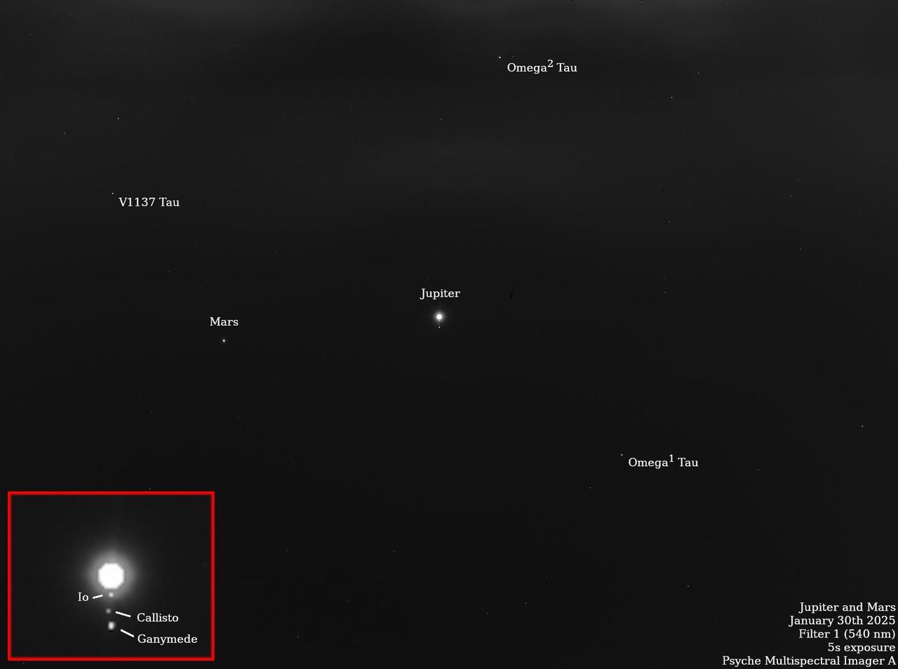
NASA's Psyche spacecraft captured multiple star and planet images in late January 2025 that include notable appearances by Mars, Jupiter, and the Jovian moons Io, Ganymede, Callisto, and Europa. The planned observation by Psyche's imaging instrument was part of a periodic maintenance and calibration test for the twin cameras that make up the imager instrument. Scientists on the imaging team, led by Arizona State University, also took images of the bright stars Vega and Canopus, which have served as standard calibration sources for astronomers for decades. The team is also using the data to assess the effects of minor wiggles or "jitter" in the spacecraft's pointing system as it points the cameras to different places in the sky. The observations of Jupiter and Mars also help the team determine how the cameras respond to solar system objects that shine by reflected sunlight, just like the Psyche asteroid. The starfield pictures shown here are long-exposure (five-second) images captured by each camera. By over-exposing Jupiter to bring out some of the background stars in the Taurus constellation, the imagers were able to capture Jupiter's fainter Galilean moons as well. The image was captured by the Psyche mission's primary camera, Imager-A, on Jan. 30. The image was obtained using the camera's "clear" filter, to provide maximum sensitivity for both bright and faint stars and solar system objects. https://photojournal.jpl.nasa.gov/catalog/PIA26563

ISS034-E-035548 (28 Jan. 2013) --- A nighttime view of the Reno, Nevada metropolitan area is featured in this image photographed by an Expedition 34 crew member on the International Space Station. Known as ?the biggest little city in the world?, the city of Reno is located in Truckee Meadows along the eastern foothills of the Sierra Nevada near the California border. It forms part of the Reno-Sparks metropolitan area?the largest such area in northern Nevada, and the second largest in the state after Las Vegas. Lake Tahoe, a major destination for skiing and other outdoor recreational activities, is located less than 50 kilometers to the southwest of the Reno-Sparks metro area. The relatively isolated nature of the metropolitan area within the surrounding terrain is highlighted in this nighttime image. The major industrial and commercial areas of both Reno and Sparks are brightly lit at center. The major street grid is visible as orange linear features adjacent to the industrial/commercial areas. Residential areas appear dark in contrast. The Reno-Tahoe International Airport (center) is visible as a dark, dagger-shaped region in the southeast quarter of the metropolitan area. At the time this photograph was taken, the moon was in a waning gibbous phase (98 percent of a full moon). Moonlight provided enough illumination of the ground surface such that the topography, accentuated by snow cover, surrounding the Reno-Sparks area is clearly visible (upper right, lower right) following color enhancement.
Day In The Life of Artemis Employees
Day In The Life of Artemis Employees
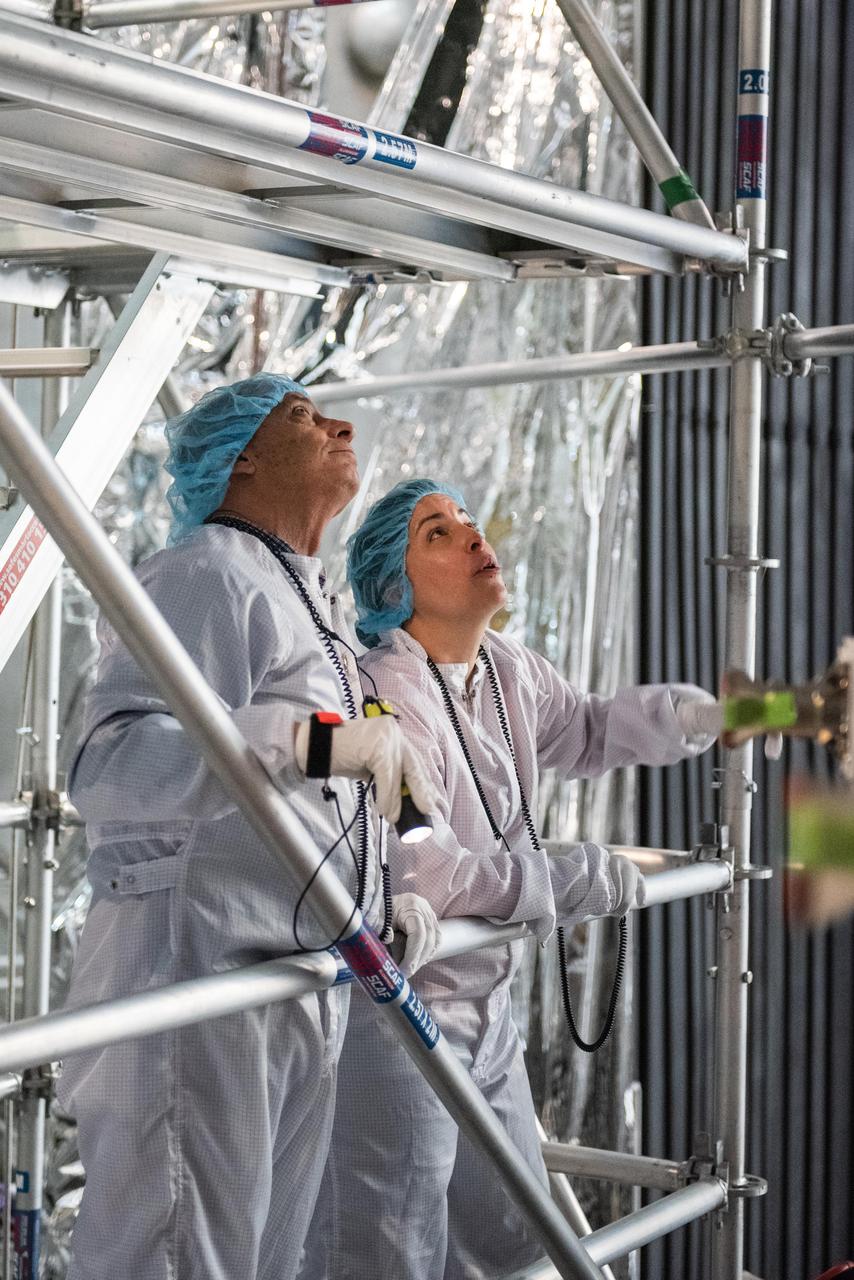
Day In The Life of Artemis Employees

Day In The Life of Artemis Employees
Lori Losey, an employee of Arcata Associates at Dryden, was honored with NASA's 2004 Videographer of the Year award for her work in two of the three categories in the NASA video competition, public affairs and documentation. In the public affairs category, Losey received a first-place citation for her footage of an Earth Science mission that was flown aboard NASA's DC-8 Flying Laboratory in South America last year. Her footage not only depicted the work of the scientists aboard the aircraft and on the ground, but she also obtained spectacular footage of flora and fauna in the mission's target area that helped communicate the environmental research goals of the project. Losey also took first place in the documentation category for her acquisition of technical videography of the X-45A Unmanned Combat Air Vehicle flight tests. The video, shot with a hand-held camera from the rear seat of a NASA F/A-18 mission support aircraft, demonstrated her capabilities in recording precise technical visual data in a very challenging airborne environment. The award was presented to Losey during a NASA reception at the National Association of Broadcasters convention in Las Vegas April 19. A three-judge panel evaluated entries for public affairs, documentation and production videography on professional excellence, technical quality, originality, creativity within restrictions of the project, and applicability to NASA and its mission. Entries consisted of a continuous video sequence or three views of the same subject for a maximum of three minutes duration. Linda Peters, Arcata Associates' Video Systems Supervisor at NASA Dryden, noted, "Lori is a talented videographer who has demonstrated extraordinary abilities with the many opportunities she has received in her career at NASA." Losey's award was the second major NASA video award won by members of the Dryden video team in two years. Steve Parcel took first place in the documentation category last year for his camera and editing
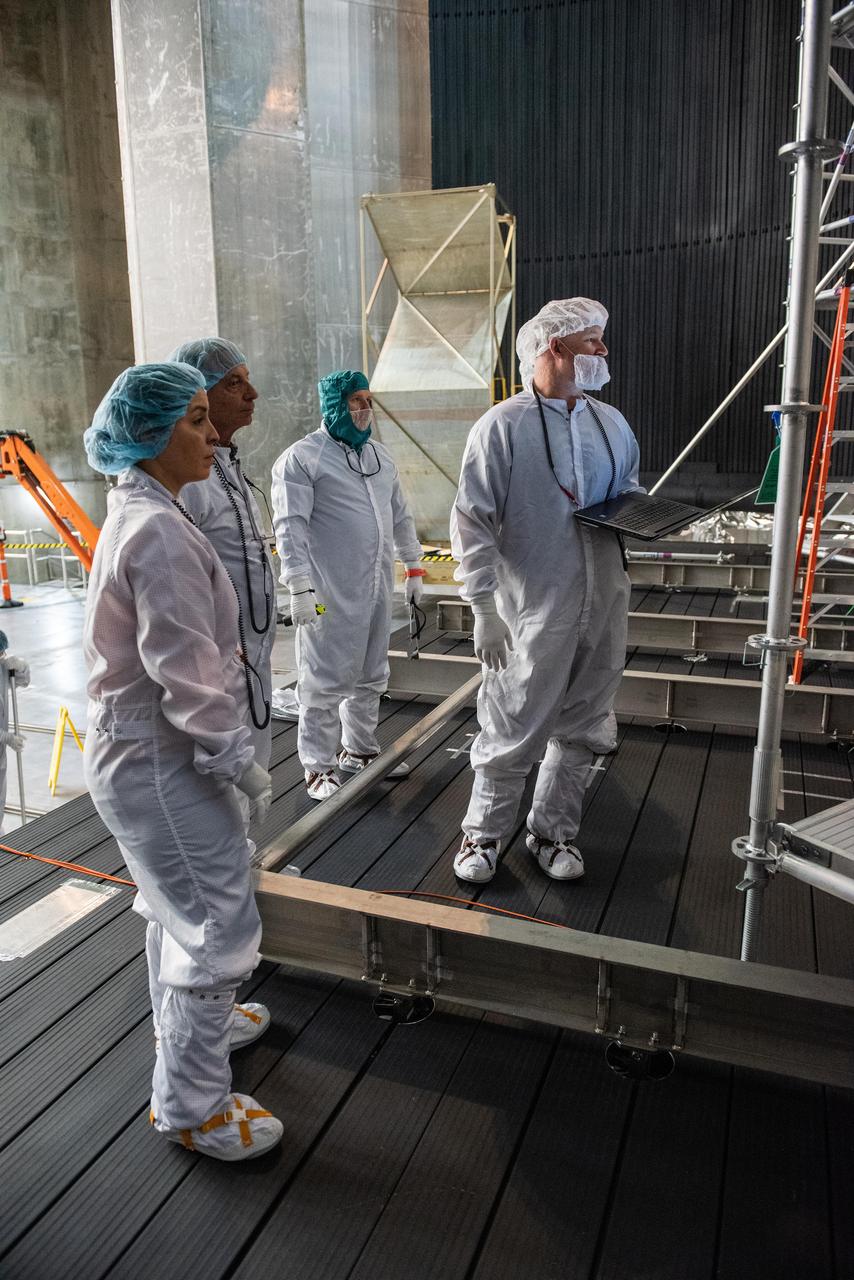
Day In The Life of Artemis Employees
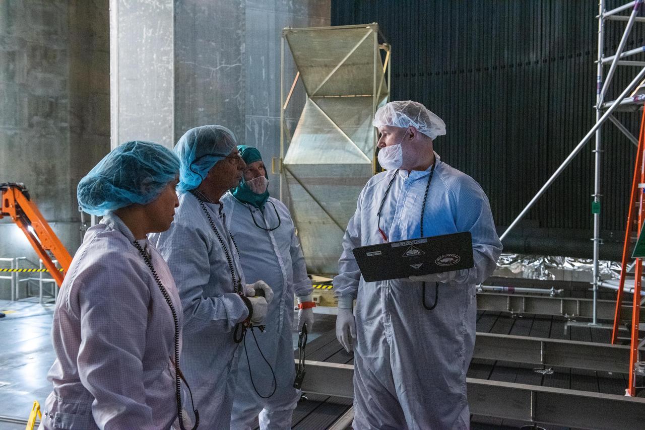
Day In The Life of Artemis Employees