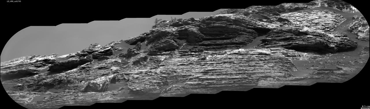
This view of "Vera Rubin Ridge" from the Chemistry and Camera (ChemCam) instrument on NASA's Curiosity Mars rover shows sedimentary layers, mineral veins and effects of wind erosion. This area of lower Mount Sharp became a ridge by being more resistant to erosion than neighboring portions of the layered mountain. Here, the wind has eroded portions of the outcrop in unusual ways, so that elongated rock fragments can be seen protruding into the sky. ChemCam's telescopic Remote Micro-Imager took the 10 component images of this mosaic on Aug. 24, 2017, during the 1,795th Martian day, or sol, of Curiosity's work on Mars. The camera was about 141 feet (43 meters) away from the pictured portion of the ridge. The rover's location at the time, in relation to the ridge, is shown in a Sol 1794 traverse map. The scale bar at lower right indicates how wide a feature 3.3 inches (8.5 centimeters) in width would look in the middle portion of the scene. https://photojournal.jpl.nasa.gov/catalog/PIA21853
"Vera Rubin Ridge," a favored destination for NASA's Curiosity Mars rover even before the rover landed in 2012, rises near the rover nearly five years later in this panorama from Curiosity's Mast Camera (Mastcam). The scene combines 23 images taken with the Mastcam's right-eye, telephoto-lens camera, on June 22, 2017, during the 1,734th Martian day, or sol, of Curiosity's work on Mars. The rover began ascending the ridge in September 2017. This and other Mastcam panoramas show details of the sedimentary rocks that make up the "Vera Rubin Ridge." This distinct topographic feature located on the lower slopes of Mount Sharp (Aeolis Mons) is characterized by the presence of hematite, an iron-oxide mineral, which has been detected from orbit. The Mastcam images show that the rocks making up the lower part of the ridge are characterized by distinct horizontal stratification with individual rock layers of the order of several inches (tens of centimeters) thick. Scientists on the mission are using such images to determine the ancient environment these rocks were deposited in. The repeated beds indicate progressive accumulation of sediments that now make up the lower part of Mount Sharp, although from this distance it is not possible to know if they were formed by aqueous or wind-blown processes. Close-up images collected as the rover climbs the ridge will help answer this question. The stratified rocks are cross cut by veins filled with a white mineral, likely calcium sulfate, that provide evidence of later episodes of fluid flow through the rocks. The panorama has been white-balanced so that the colors of the rock materials resemble how they would appear under daytime lighting conditions on Earth. It spans about 65 compass degrees, centered toward the south-southeast. Higher portions of Mount Sharp are visible at upper left. The Sol 1734 location just north of the ridge is shown in a Sol 1732 traverse map. An annotated figure is shown at https://photojournal.jpl.nasa.gov/catalog/PIA21849
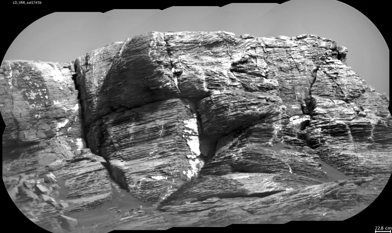
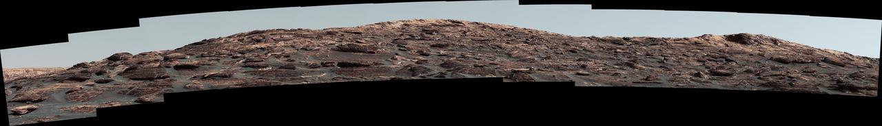
This view of "Vera Rubin Ridge" from the Chemistry and Camera (ChemCam) instrument on NASA's Curiosity Mars rover shows multiple sedimentary layers and fracture-filling deposits of minerals. Buried layers of what is now a ridge became fractured, and the fractures were filled with mineral deposits precipitated from underground fluids that moved through the fractures. ChemCam's telescopic Remote Micro-Imager took the 10 component images of this mosaic on July 3, 2017, during the 1,745th Martian day, or sol, of Curiosity's work on Mars. The camera was about 377 feet (115 meters) away from the pictured portion of the ridge. The rover's location at the time, shown in a Sol 1741 traverse map, was west of the place where it began its ascent up the ridge about two months later. The scale bar at lower right indicates how wide a feature 9 inches (22.8 centimeters) in width would look in the middle portion of the scene. https://photojournal.jpl.nasa.gov/catalog/PIA21852

Researchers used the Mast Camera (Mastcam) on NASA's Curiosity Mars rover to gain this detailed view of layers in "Vera Rubin Ridge" from just below the ridge. The scene combines 70 images taken with the Mastcam's right-eye, telephoto-lens camera, on Aug. 13, 2017, during the 1,785th Martian day, or sol, of Curiosity's work on Mars. This and other Mastcam panoramas show details of the sedimentary rocks that make up the "Vera Rubin Ridge." This distinct topographic feature located on the lower slopes of Mount Sharp (Aeolis Mons) is characterized by the presence of hematite, an iron-oxide mineral, which has been detected from orbit. The Mastcam images show that the rocks making up the lower part of the ridge are characterized by distinct horizontal stratification with individual rock layers of the order of several inches (tens of centimeters) thick. Scientists on the mission are using such images to determine the ancient environment these rocks were deposited in. The repeated beds indicate progressive accumulation of sediments that now make up the lower part of Mount Sharp, although from this distance it is not possible to know if they were formed by aqueous or wind-blown processes. Close-up images collected as the rover climbs the ridge will help answer this question. The stratified rocks are cross cut by veins filled with a white mineral, likely calcium sulfate, that provide evidence of later episodes of fluid flow through the rocks. The panorama has been white-balanced so that the colors of the rock materials resemble how they would appear under daytime lighting conditions on Earth. It spans from southeast on the left to west on the right. The Sol 1785 location just north of the ridge is shown in a Sol 1782 traverse map. The ridge was informally named in early 2017 in memory of Vera Cooper Rubin (1928-2016), whose astronomical observations provided evidence for the existence of the universe's dark matter. An annotated figure is shown at https://photojournal.jpl.nasa.gov/catalog/PIA21850
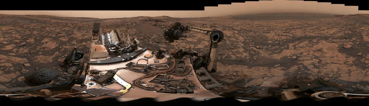
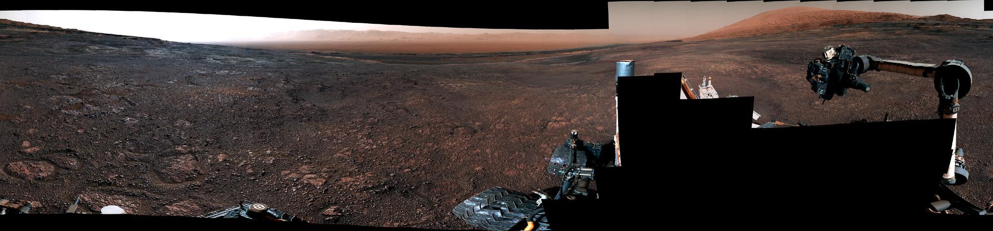
After snagging a new rock sample on August 9, 2018 (Sol 2137), NASA's Curiosity rover surveyed its surroundings on Mars, producing a 360-degree panorama of its current location on Vera Rubin Ridge. The scene is presented with a color adjustment that approximates white balancing, to resemble how the rocks and sand would appear under daytime lighting conditions on Earth. Two versions are included here: one with scale bars, and one without. The panorama includes umber skies, darkened by a fading global dust storm. It also includes a rare view by the Mast Camera of the rover itself, revealing a thin layer of dust on Curiosity's deck. In the foreground is the rover's most recent drill target, named "Stoer" after a town in Scotland near where important discoveries about early life on Earth were made in lakebed sediments. https://photojournal.jpl.nasa.gov/catalog/PIA22545
The Mast Camera (Mastcam) on NASA's Curiosity Mars rover captured this view of "Vera Rubin Ridge" about two weeks before the rover started ascending this steep ridge on lower Mount Sharp. The view combines 13 images taken with the Mastcam's right-eye, telephoto-lens camera, on Aug. 19, 2017, during the 1,790th Martian day, or sol, of Curiosity's work on Mars. This and other Mastcam panoramas show details of the sedimentary rocks that make up the "Vera Rubin Ridge." This distinct topographic feature located on the lower slopes of Mount Sharp (Aeolis Mons) is characterized by the presence of hematite, an iron-oxide mineral, which has been detected from orbit. The Mastcam images show that the rocks making up the lower part of the ridge are characterized by distinct horizontal stratification with individual rock layers of the order of several inches (tens of centimeters) thick. Scientists on the mission are using such images to determine the ancient environment these rocks were deposited in. The repeated beds indicate progressive accumulation of sediments that now make up the lower part of Mount Sharp, although from this distance it is not possible to know if they were formed by aqueous or wind-blown processes. Close-up images collected as the rover climbs the ridge will help answer this question. The stratified rocks are cross cut by veins filled with a white mineral, likely calcium sulfate, that provide evidence of later episodes of fluid flow through the rocks. The panorama has been white-balanced so that the colors of the rock materials resemble how they would appear under daytime lighting conditions on Earth. It spans about 55 compass degrees centered to the south-southeast. The Sol 1790 location just north of the ridge is shown in a Sol 1789 traverse map. The ridge was informally named in early 2017 in memory of Vera Cooper Rubin (1928-2016), whose astronomical observations provided evidence for the existence of the universe's dark matter. An annotated figure is shown at https://photojournal.jpl.nasa.gov/catalog/PIA21851

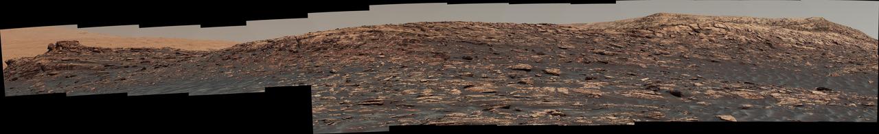
This panorama from the Mast Camera (Mastcam) of NASA's Curiosity Mars rover shows details of "Vera Rubin Ridge," which stretches about 4 miles (6.5 kilometers), end-to-end, on the northwestern flank of lower Mount Sharp. The view combines 112 images taken with the Mastcam's right-eye camera, which has a telephoto lens, on April 4, 2017, during the 1,657th Martian day, or sol, of Curiosity's work on Mars. It has been white-balanced so that colors of the rock and sand materials resemble how they would appear under daytime lighting conditions on Earth. It spans from east-southeast on the left to south-southwest on the right, from a rover location about half a mile (0.8 kilometer) from the closest part of the ridge. Hematite, an iron-oxide mineral, has been detected in this ridge by the Compact Reconnaissance Imaging Spectrometer for Mars (CRISM) on NASA's Mars Reconnaissance Orbiter. The ridge has been an identified destination for Curiosity since before the rover's August 2012 landing near the base of Mount Sharp, inside Gale Crater. The ridge was informally named in early 2017 in memory of Vera Cooper Rubin (1928-2016), whose astronomical observations provided evidence for the existence of the universe's dark matter. An annotated version and full resolution TIFF files are available at https://photojournal.jpl.nasa.gov/catalog/PIA21717
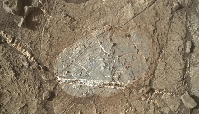
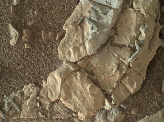
A mineral vein with bright and dark portions dominates this image of a Martian rock target called "Rona," which is near the southern, upper edge of "Vera Rubin Ridge" on Mount Sharp. The Mars Hand Lens Imager (MAHLI) camera on NASA's Curiosity Mars rover took this image on Jan. 17, 2018, during the 1,937th Martian day, or sol, of Curiosity's work on Mars. The grayer area in the center is roughly 2 inches by 3 inches (about 5 by 8 centimeters). That area, including a portion of the vein, was brushed with the Curiosity's wire-bristled Dust Removal Tool before the image was taken. https://photojournal.jpl.nasa.gov/catalog/PIA22214
This look ahead from NASA's Curiosity Mars rover includes four geological layers to be examined by the mission, and higher reaches of Mount Sharp beyond the planned study area. The redder rocks of the foreground are part of the Murray formation. Pale gray rocks in the middle distance of the right half of the image are in the Clay Unit. A band between those terrains is "Vera Rubin Ridge." Rounded brown knobs beyond the Clay Unit are in the Sulfate Unit, beyond which lie higher portions of the mountain. The view combines six images taken with the rover's Mast Camera (Mastcam) on Jan. 24, 2017, during the 1,589th Martian day, or sol, of Curiosity's work on Mars, when the rover was still more than half a mile (about a kilometer) north of Vera Rubin Ridge. The panorama has been white-balanced so that the colors of the rock and sand materials resemble how they would appear under daytime lighting conditions on Earth. It spans from east-southeast on the left to south on the right. The Sol 1589 location was just north of the waypoint labeled "Ogunquit Beach" on a map of the area that also shows locations of the Murray formation, Vera Rubin Ridge, Clay Unit and Sulfate Unit. The ridge was informally named in early 2017 in memory of Vera Cooper Rubin (1928-2016), whose astronomical observations provided evidence for the existence of the universe's dark matter. Annotated and full resolution TIFF files are available at https://photojournal.jpl.nasa.gov/catalog/PIA21716
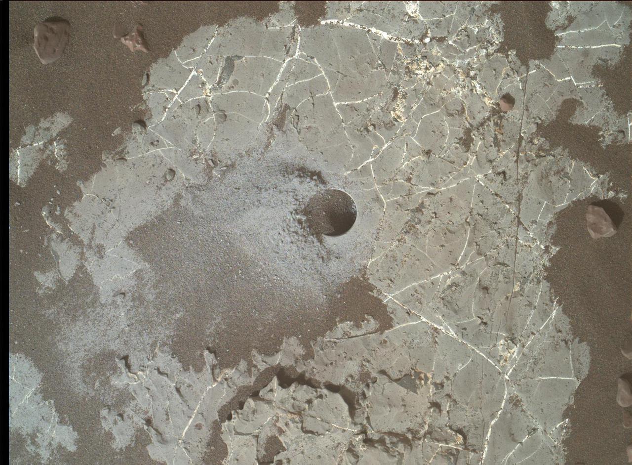
This image shows the Highfield drill hole made by NASA's Curiosity rover as it was collecting a sample on "Vera Rubin Ridge" in Gale Crater on Mars. Drill powder from this hole was enriched in carbon-12. The image was taken by the Mars Hand Lens Imager on Dec. 10, 2021, the 2,247th Martian day, or sol, of the mission. https://photojournal.jpl.nasa.gov/catalog/PIA25045
A selfie taken by NASA's Curiosity Mars rover on Sol 2291 (January 15) at the "Rock Hall" drill site, located on Vera Rubin Ridge. This was Curiosity's 19th drill site. The drill hole is visible to the rover's lower-left; the entire scene is slightly dustier than usual due to a regional dust storm affecting the area. The selfie is composed of 57 individual images taken by the rover's Mars Hand Lens Imager (MAHLI), a camera on the end of the rover's robotic arm. The images are then stitched together into a panorama. https://photojournal.jpl.nasa.gov/catalog/PIA22960
A vantage point on "Vera Rubin Ridge" provided NASA's Curiosity Mars rover this detailed look back over the area where it began its mission inside Gale Crater, plus more-distant features of the crater. This view toward the north-northeast combines eight images taken by the right-eye, telephoto-lens camera of Curiosity's Mast Camera (Mastcam). It shows more detail of a fraction of the area pictured in a more sweeping panorama (see PIA22210) acquired from the same rover location using Mastcam's left-eye, wider-angle-lens camera. The scene has been white-balanced so the colors of the rock materials resemble how they would appear under daytime lighting conditions on Earth. The component images were taken on Oct. 25, 2017, during the 1,856th Martian day, or sol, of the rover's work on Mars. At that point, Curiosity had gained 1,073 feet (327 meters) in elevation and driven 10.95 miles (17.63 kilometers) from its landing site. Mount Sharp stands about 3 miles (5 kilometers) high in the middle of Gale Crater, which spans 96 miles (154 kilometers) in diameter. Vera Rubin Ridge is on the northwestern flank of lower Mount Sharp. The right foreground of this panorama shows a portion of Vera Rubin Ridge. In the distance is the northern wall of Gale Crater, with the rim crest forming the horizon roughly 25 miles (40 kilometers) from the rover's location. An annotated version, Figure 1, indicates where the rover landed (at "Bradbury Landing") in 2012 and the initial portion of its drive, including investigation sites "Yellowknife Bay," "Darwin" and "Cooperstown." The rover's exact landing site is hidden behind a slight rise. The heat shield, back shell, and parachute used during the spacecraft's descent are within the pictured area but not recognizable due to the distance and to camouflaging by dust. At Yellowknife Bay in 2013, the mission found evidence of an ancient freshwater-lake environment that offered all of the basic chemical ingredients for microbial life. Figure 2 includes three scale bars: of 40 meters (131 feet) at a distance of about 1,530 meters (1,673 yards) near the base of Mount Sharp; of 1,500 meters (1,640 yards) at a distance of about 30.75 kilometers (19.1 miles) near the base of the crater wall; and of 2,000 meters (1.2 miles) at a distance of about 41.2 kilometers (25.6 miles) at the crest of the rim. Annotated images are available at https://photojournal.jpl.nasa.gov/catalog/PIA22209
This panorama was taken on Dec. 19, 2018, (Sol 2265) by the Mast Camera (Mastcam) on NASA's Curiosity Mars rover. The rover's last drill location on Vera Rubin Ridge is visible, as well as the clay region it will spend the next year exploring. The scene combines 122 images taken with Mastcam's left-eye camera. It is presented with a color adjustment that approximates white balancing to resemble how the rocks and sand would appear under daytime lighting conditions on Earth. https://photojournal.jpl.nasa.gov/catalog/PIA23042
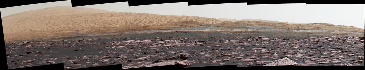
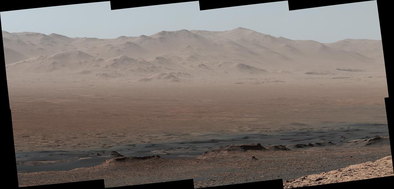
The hills and troughs in this little valley, carved between a ridge and cliffs higher up Mount Sharp, almost look like undulating waves. The Mast Camera (Mastcam) on NASA's Curiosity Mars rover captured this mosaic as it explored the "clay-bearing unit" on Jan. 23, 2019 (Sol 2299). At the top left corner is part of the Vera Rubin Ridge, from which Curiosity departed earlier this year; the rocky hill at center left has been nicknamed "Knockfarril Hill." The science team is trying to figure out how this landscape formed over billions of years. At present, the clearest takeaway is that the clay-bearing unit is softer than the ridge: The former has eroded into a valley between the ridge and Mount Sharp, while the ridge has resisted erosion. The scene is presented with a color adjustment that approximates white balancing to resemble how the rocks and sand would appear under daytime lighting conditions on Earth. https://photojournal.jpl.nasa.gov/catalog/PIA23137
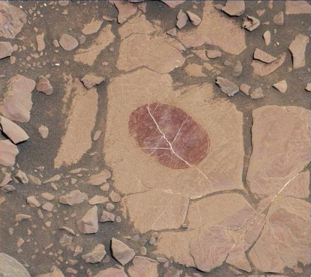
On a part of "Vera Rubin Ridge" where rover-team researchers sought to determine whether dust coatings are hiding rocks' hematite content, the Mast Camera (Mastcam) on NASA's Curiosity Mars rover took this image of a rock surface that had been brushed with the rover's Dust Removal Tool. The image is shown in the usual full color of featured Mastcam images: with a color adjustment similar to white balancing for approximating how the rocks and sand would appear under daytime lighting conditions on Earth. Sunlight on Mars is tinged by the dusty atmosphere and this adjustment helps geologists recognize color patterns they are familiar with on Earth. In this case, the purplish tint of the brushed area suggested fine-grained hematite. Bright lines within the rocks are fractures filled with calcium sulfate minerals. The brushed area is about 2.5 inches (6 centimeters) across. The image was taken on Sept. 17, 2017, during the 1,819th Martian day, or sol, of Curiosity's work on Mars. Mastcam also imaged this same scene using three special filters that help to identify hematite, an iron-oxide mineral that can provide information about ancient environmental conditions. A science-filters image identifies hematite in this brushed target even more clearly. https://photojournal.jpl.nasa.gov/catalog/PIA22067

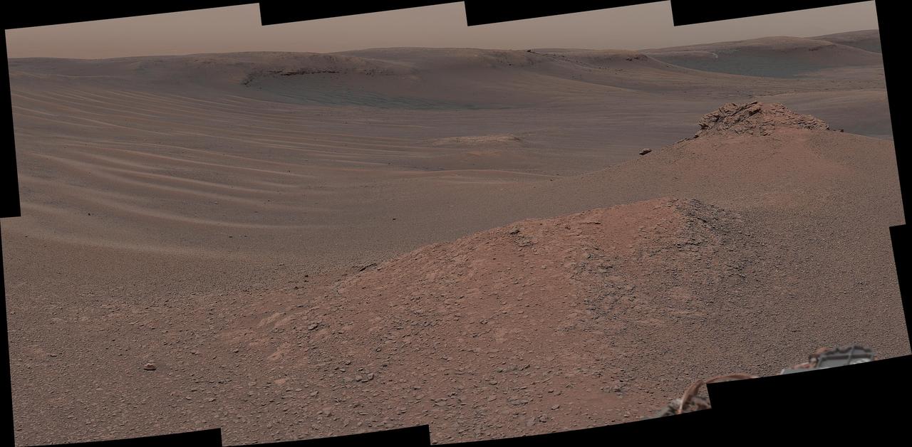
Climbing "Vera Rubin Ridge" provided NASA's Curiosity Mars rover this sweeping vista of the interior and rim of Gale Crater, including much of the rover's route during its first five-and-a-half years on Mars and features up to about 50 miles (85 kilometers) away. The scene spans from southwest on the left to northeast on the right, combining 16 side-by-side images taken by the left-eye, wider-angle-lens camera of Curiosity's Mast Camera (Mastcam). It has been white-balanced so the colors of the rock materials resemble how they would appear under daytime lighting conditions on Earth. The component images were taken on Oct. 25, 2017, during the 1,856th Martian day, or sol, of the rover's work on Mars. At that point, Curiosity had gained 1,073 feet (327 meters) in elevation and driven 10.95 miles (17.63 kilometers) from its landing site. Mount Sharp stands about 3 miles (5 kilometers) high in the middle of Gale Crater, which spans 96 miles (154 kilometers) in diameter. Vera Rubin Ridge is on the northwestern flank of lower Mount Sharp. The foreground of this panorama shows portions of lower Mount Sharp. The middle distance shows the floor of Gale Crater. Most of the horizon is formed by the crater's rim. The top of the rim is about 1.2 miles (2 kilometers) higher than the rover's position. On the horizon near the center of the image is a glimpse outside of Gale Crater, to a peak about 50 miles (85 kilometers) from the rover. An annotated version, Figure 1, indicates the rover's approximate path since its 2012 landing, identifies some of the sites it has investigated along the way, such as "Yellowknife Bay," "The Kimberley," "Namib Dune" and "Murray Buttes"; and points out other geological features visible in the scene, such as the channel of Peace Vallis, an ancient streambed descending from the crater rim. The relative positions of the labeled features are also mapped on an accompanying orbital view in PIA22208, with two areas color-coded for ease of matching them in the annotated panorama and the orbital view. Figure 2 is a version with a white-line box indicating the smaller area covered in a more-detailed vista (see PIA22209) taken from this same rover location by Mastcam's right-eye, telephoto-lens camera. It also includes three scale bars: of 50 meters (164 feet) at a distance of 1,170 meters (1,280 yards) near the base of Mount Sharp; of 1,000 meters (1,094 yards) at a distance of about 23.4 kilometers (14.5 miles) near the base of the crater wall; and of 2 kilometers (1.2 miles) at a distance of about 31.5 kilometers (19.6 miles) at the crest of the rim. Annotated images are available at https://photojournal.jpl.nasa.gov/catalog/PIA22210
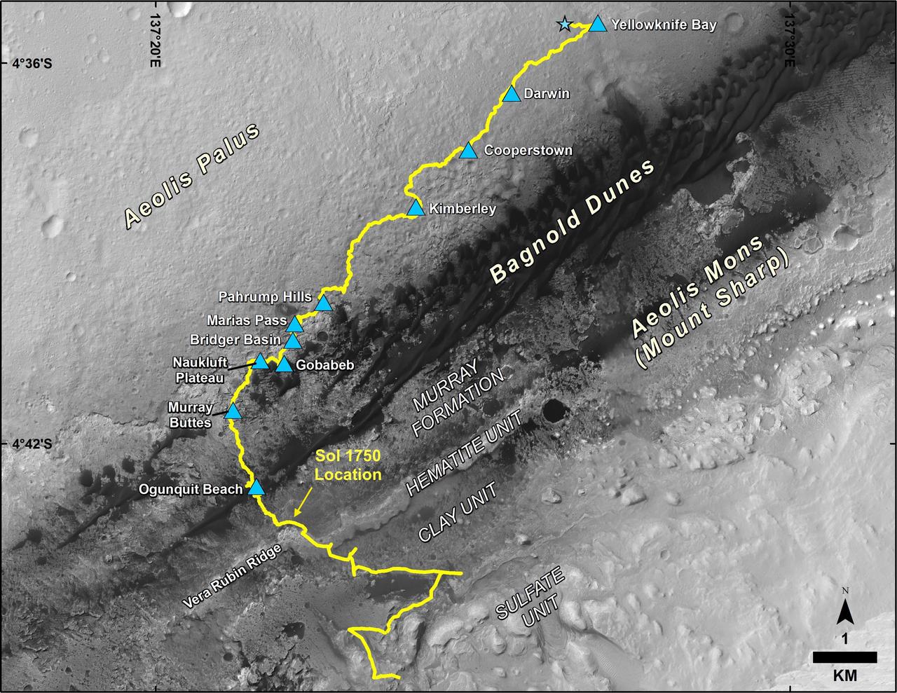
This map shows the route driven by NASA's Curiosity Mars rover, from the location where it landed in August 2012 to its location in July 2017, and its planned path to additional geological layers of lower Mount Sharp. The blue star near top center marks "Bradbury Landing," the site where Curiosity arrived on Mars on Aug. 5, 2012, PDT (Aug. 6, EDT and Universal Time). Blue triangles mark waypoints investigated by Curiosity on the floor of Gale Crater and, starting with "Pahrump Hills," on Mount Sharp. The Sol 1750 label identifies the rover's location on July 9, 2017, the 1,750th Martian day, or sol, since the landing. In July 2017, the mission is examining "Vera Rubin Ridge" from the downhill side of the ridge. Spectrometry observations from NASA's Mars Reconnaissance Orbiter have detected hematite, an iron-oxide mineral, in the ridge. Curiosity's planned route continues to the top of the ridge and then to geological units where clay minerals and sulfate minerals have been detected from orbit. The base image for the map is from the High Resolution Imaging Science Experiment (HiRISE) camera on the Mars Reconnaissance Orbiter. North is up. "Bagnold Dunes" form a band of dark, wind-blown material at the foot of Mount Sharp. https://photojournal.jpl.nasa.gov/catalog/PIA21720
The dark, stick-shaped features clustered on this Martian rock are about the size of grains of rice. This is a focus-merged view from the Mars Hand Lens Imager (MAHLI) camera on NASA's Curiosity Mars rover. It covers an area about 2 inches (5 centimeters) across. The focus-merged product was generated autonomously by MAHLI combining the in-focus portions of a few separate images taken at different focus settings on Jan. 1, 2018, during the 1,922nd Martian day, or sol, of Curiosity's work on Mars. This rock target, called "Haroldswick," is near the southern, uphill edge of "Vera Rubin Ridge" on lower Mount Sharp. The origin of the stick-shaped features is uncertain. One possibility is that they are erosion-resistant bits of dark material from mineral veins cutting through rocks in this area. https://photojournal.jpl.nasa.gov/catalog/PIA22213
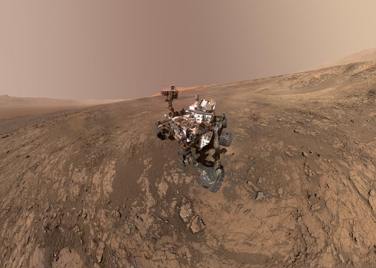
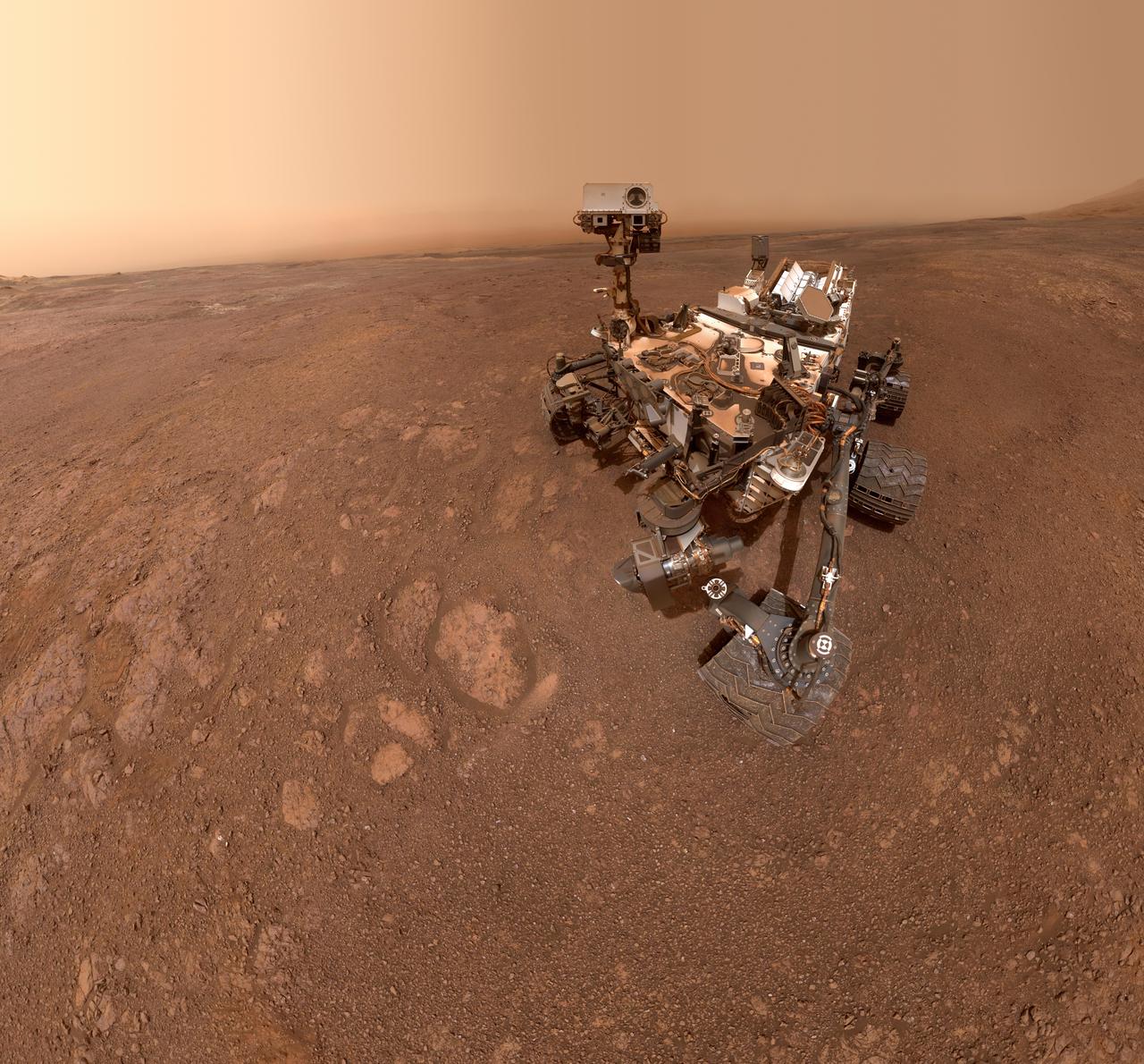
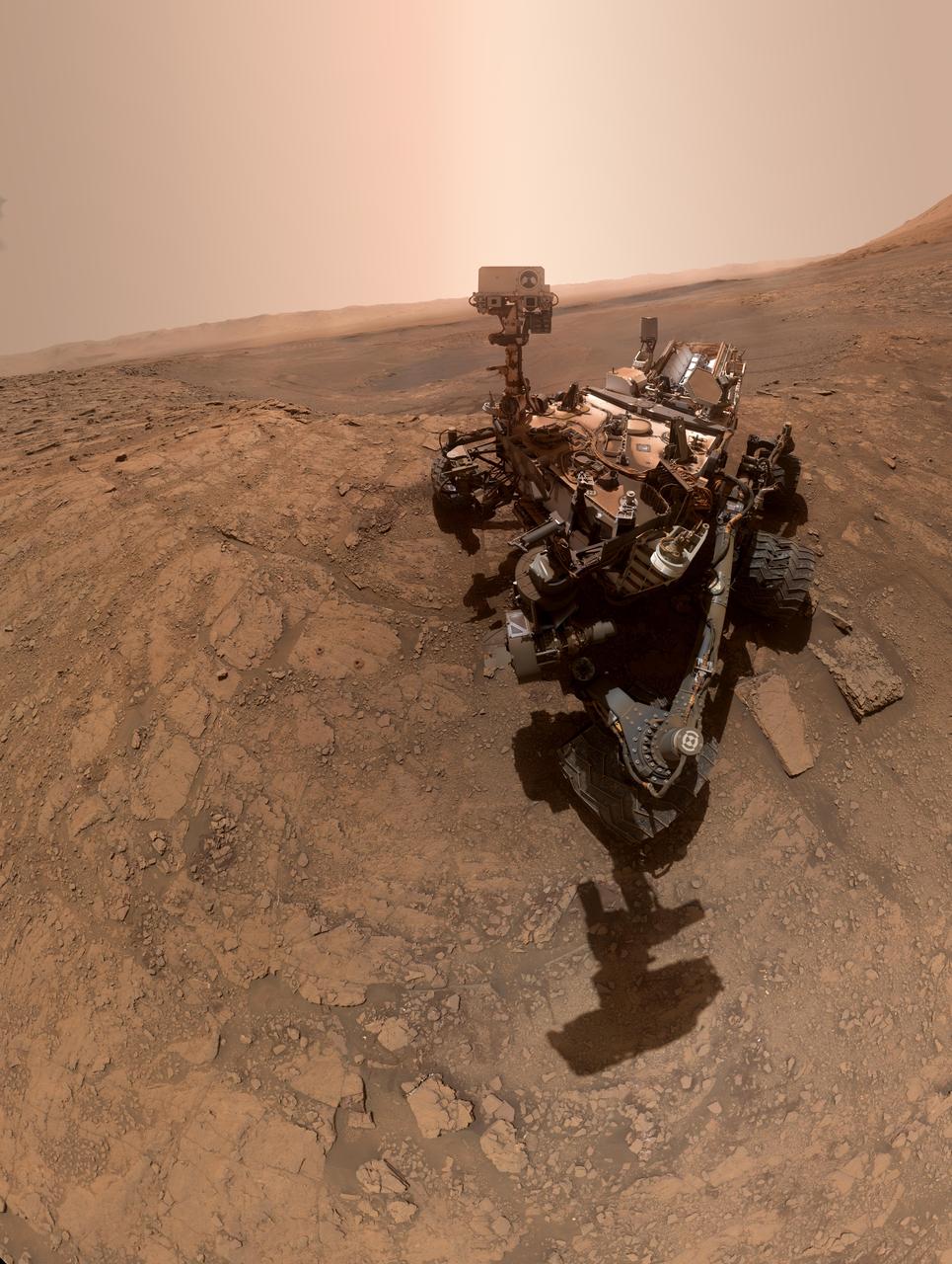
This self-portrait of NASA's Curiosity Mars rover shows the vehicle on Vera Rubin Ridge, which it's been investigating for the past several months. Directly behind the rover is the start of a clay-rich slope scientists are eager to begin exploring. In the coming week, Curiosity will begin to climb this slope. North is on the left and west is on the right, with Gale Crater's rim on the horizon of both edges. Poking up just behind Curiosity's mast is Mount Sharp, photobombing the robot's selfie. Curiosity landed on Mars five years ago with the intention of studying lower Mount Sharp, where it will remain for all of its time on Mars. The mountain's base provides access to layers formed over millions of years. These layers formed in the presence of water -- likely due to a lake or lakes that sat at the bottom of the mountain, which sits inside of Gale Crater. This mosaic was assembled from dozens of images taken by Curiosity's Mars Hands Lens Imager (MAHLI). They were all taken on Jan. 23, 2018, during Sol 1943. The view does not include the rover's arm nor the MAHLI camera itself, except in the miniature scene reflected upside down in the parabolic mirror at the top of the mast. That mirror is part of Curiosity's Chemistry and Camera (ChemCam) instrument. MAHLI appears in the center of the mirror. Wrist motions and turret rotations on the arm allowed MAHLI to acquire the mosaic's component images. The arm was positioned out of the shot in the images, or portions of images, that were used in this mosaic. A full-resolution image is available at https://photojournal.jpl.nasa.gov/catalog/PIA22207
NASA's Curiosity rover took this selfie on Oct. 11, 2019, the 2,553rd Martian day, or sol, of its mission. The rover drilled twice in this location, nicknamed "Glen Etive" (pronounced "glen EH-tiv"). About 984 feet (300 meters) behind the rover, Vera Rubin Ridge rises up. Behind it lies the floor of Gale Crater, which Curiosity is exploring, and the northern rim of the crater. Just left of the rover are the two drill holes, called "Glen Etive 1" (right) and "Glen Etive 2" (left). Curiosity performed its first wet-chemistry experiment on a drilled sample at this location. The rover can analyze the chemical composition of rock samples by powderizing them with the drill, then dropping the samples into a portable lab in its belly called Sample Analysis at Mars (SAM). This panorama is made up of 57 individual images taken by the Mars Hand Lens Imager (MAHLI), a camera on the end of the rover's robotic arm. The images are stitched together into a panorama; the robotic arm isn't visible in the parts of the images used in the composite. https://photojournal.jpl.nasa.gov/catalog/PIA23378
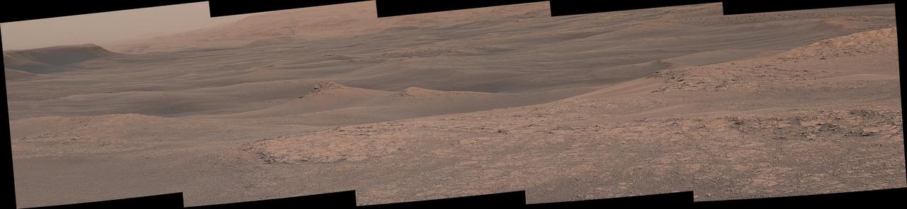
The Mast Camera (Mastcam) on NASA's Curiosity Mars rover captured this mosaic as it explored the "clay-bearing unit" on Feb. 3, 2019 (Sol 2309). This landscape includes the rocky landmark nicknamed "Knockfarril Hill" (center right) and the edge of Vera Rubin Ridge, which runs along the top of the scene. Made of many individual images, this mosaic includes a variety of geological features, such as several kinds of bedrock and sand. The clay-bearing unit has been an important scientific destination since before Curiosity launched. NASA's Mars Reconnaissance Orbiter (MRO) spied a strong clay "signal" in this region, indicating that water may have played a role in its formation. On its long trek since landing in 2012, Curiosity has discovered many examples of mudstones containing clay minerals. The scene is presented with a color adjustment that approximates white balancing to resemble how the rocks and sand would appear under daytime lighting conditions on Earth. https://photojournal.jpl.nasa.gov/catalog/PIA23139
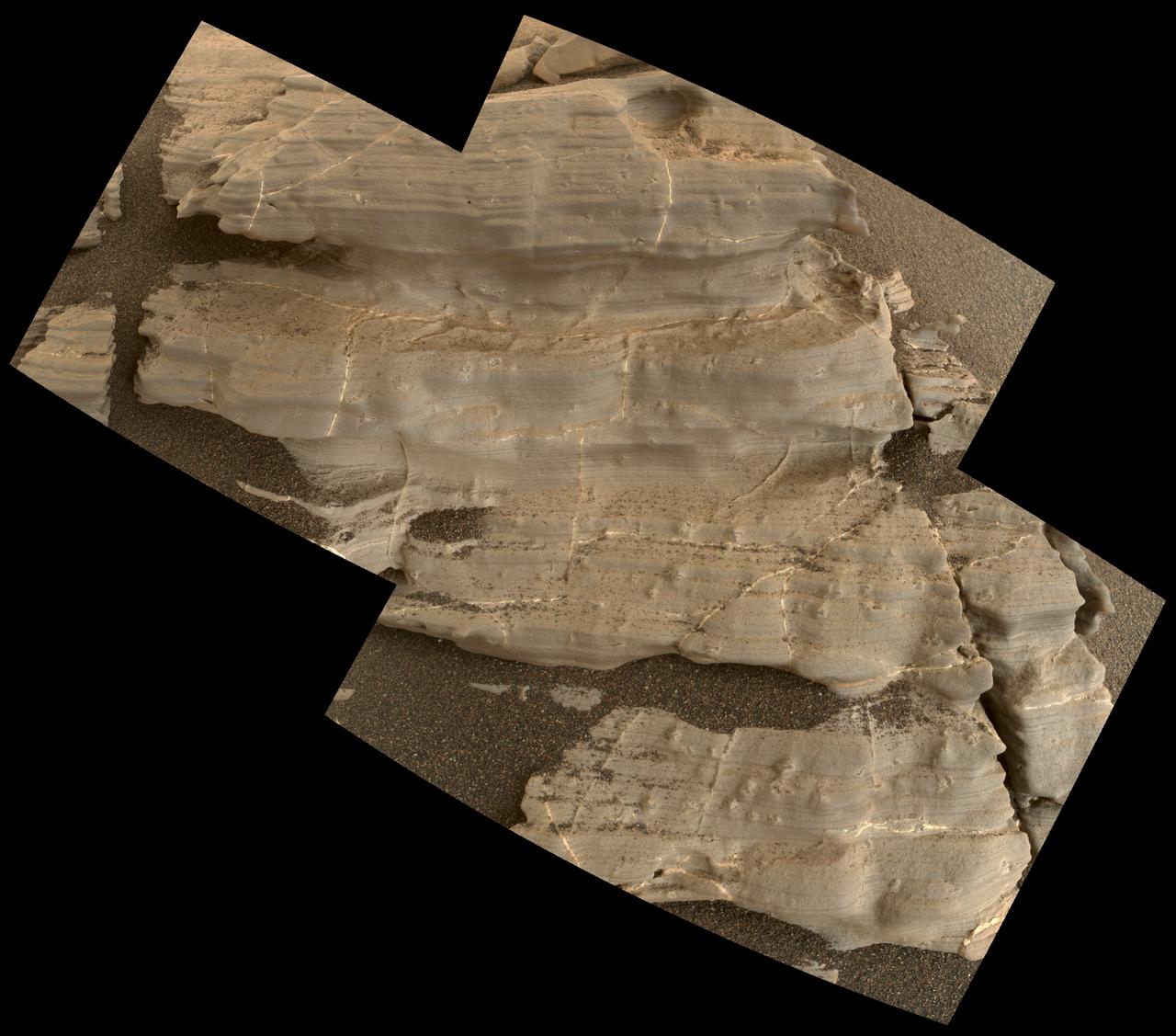
This exposure of finely laminated bedrock on Mars includes tiny crystal-shaped bumps, plus mineral veins with both bright and dark material. This rock target, called "Jura," was imaged by the Mars Hand Lens Imager (MAHLI) camera on NASA's Curiosity Mars rover on Jan. 4, 2018, during the 1,925th Martian day, or sol, of the rover's work on Mars. The view combines three MAHLI frames covering a postcard-size patch of the rock. Fig. 1 includes a scale bar of 2 centimeters (about 0.8 inch) and a blow-up of a "swallowtail" crystal shape. The combination of simpler "lenticular" crystal shapes with swallowtails and more complex "lark's foot" and star shapes is characteristic of crystals of gypsum, a type of calcium sulfate. To the right of a prominent swallowtail near the top of the image is one bright mineral vein and another with both bright and dark portions. This rock is near the southern, uphill edge of "Vera Rubin Ridge" on lower Mount Sharp. An annotated image (Fig. 1) is available at https://photojournal.jpl.nasa.gov/catalog/PIA22211

The surface of the Martian rock target in this stereo image includes small hollows with a "swallowtail" shape characteristic of some gypsum crystals, most evident in the lower left quadrant. These hollows may have resulted from the original crystallizing mineral subsequently dissolving away. The view appears three-dimensional when seen through blue-red glasses with the red lens on the left. The scene spans about 2.5 inches (6.5 centimeters). This rock target, called "Funzie," is near the southern, uphill edge of "Vera Rubin Ridge" on lower Mount Sharp. The stereo view combines two images taken from slightly different angles by the Mars Hand Lens Imager (MAHLI) camera on NASA's Curiosity Mars rover, with the camera about 4 inches (10 centimeters) above the target. Fig. 1 and Fig. 2 are the separate "right-eye" and "left-eye" images, taken on Jan. 11, 2018, during the 1,932nd Martian day, or sol, of the rover's work on Mars. Right-eye and left-eye images are available at https://photojournal.jpl.nasa.gov/catalog/PIA22212
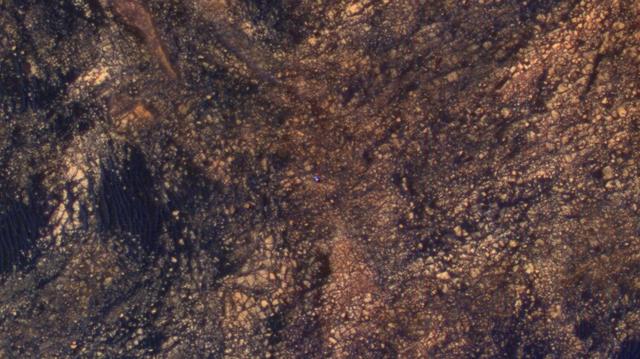
The feature that appears bright blue at the center of this scene is NASA's Curiosity Mars rover on the northwestern flank of Mount Sharp, viewed by NASA's Mars Reconnaissance Orbiter. Curiosity is approximately 10 feet long and 9 feet wide (3.0 meters by 2.8 meters). The view is a cutout from observation ESP_050897_1750 taken by the High Resolution Imaging Science Experiment (HiRISE) camera on the orbiter on June 5, 2017. HiRISE has been imaging Curiosity about every three months, to monitor the surrounding features for changes such as dune migration or erosion. When the image was taken, Curiosity was partway between its investigation of active sand dunes lower on Mount Sharp, and "Vera Rubin Ridge," a destination uphill where the rover team intends to examine outcrops where hematite has been identified from Mars orbit. The rover's surroundings include tan rocks and patches of dark sand. As in previous HiRISE color images of Curiosity since the rover was at its landing site, the rover appears bluer than it really is. HiRISE color observations are recorded in a red band, a blue-green band and an infrared band, and displayed in red, green and blue. This helps make differences in Mars surface materials apparent, but does not show natural color as seen by the human eye. Lower Mount Sharp was chosen as a destination for the Curiosity mission because the layers of the mountain offer exposures of rocks that record environmental conditions from different times in the early history of the Red Planet. Curiosity has found evidence for ancient wet environments that offered conditions favorable for microbial life, if Mars has ever hosted life. https://photojournal.jpl.nasa.gov/catalog/PIA21710
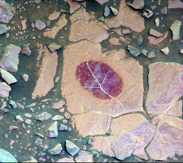
This false-color image demonstrates how use of special filters available on the Mast Camera (Mastcam) of NASA's Curiosity Mars rover can reveal the presence of certain minerals in target rocks. It is a composite of images taken through three "science" filters chosen for making hematite, an iron-oxide mineral, stand out as exaggerated purple. This target rock, called "Christmas Cove," lies in an area on Mars' "Vera Rubin Ridge" where Mastcam reconnaissance imaging (see PIA22065) with science filters suggested a patchy distribution of exposed hematite. Bright lines within the rocks are fractures filled with calcium sulfate minerals. Christmas Cove did not appear to contain much hematite until the rover team conducted an experiment on this target: Curiosity's wire-bristled brush, the Dust Removal Tool, scrubbed the rock, and a close-up with the Mars Hand Lens Imager (MAHLI) confirmed the brushing. The brushed area is about is about 2.5 inches (6 centimeters) across. The next day -- Sept. 17, 2017, on the mission's Sol 1819 -- this observation with Mastcam and others with the Chemistry and Camera (ChemCam showed a strong hematite presence that had been subdued beneath the dust. The team is continuing to explore whether the patchiness in the reconnaissance imaging may result more from variations in the amount of dust cover rather than from variations in hematite content. Curiosity's Mastcam combines two cameras: one with a telephoto lens and the other with a wider-angle lens. Each camera has a filter wheel that can be rotated in front of the lens for a choice of eight different filters. One filter for each camera is clear to all visible light, for regular full-color photos, and another is specifically for viewing the Sun. Some of the other filters were selected to admit wavelengths of light that are useful for identifying iron minerals. Each of the filters used for this image admits light from a narrow band of wavelengths, extending to only about 5 nanometers longer or shorter than the filter's central wavelength. Three observations are combined for this image, each through one of the filters centered at 751 nanometers (in the near-infrared part of the spectrum just beyond red light), 527 nanometers (green) and 445 nanometers (blue). Usual color photographs from digital cameras -- such as a Mastcam one of this same place (see PIA22067) -- also combine information from red, green and blue filtering, but the filters are in a microscopic grid in a "Bayer" filter array situated directly over the detector behind the lens, with wider bands of wavelengths. Mastcam's narrow-band filters used for this view help to increase spectral contrast, making blues bluer and reds redder, particularly with the processing used to boost contrast in each of the component images of this composite. Fine-grained hematite preferentially absorbs sunlight around in the green portion of the spectrum around 527 nanometers. That gives it the purple look from a combination of red and blue light reflected by the hematite and reaching the camera through the other two filters. https://photojournal.jpl.nasa.gov/catalog/PIA22066
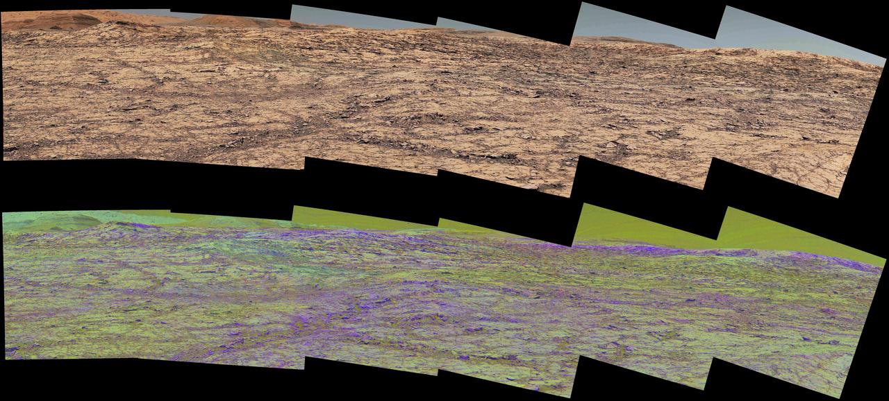
This pair of images from the Mast Camera (Mastcam) on NASA's Curiosity rover illustrates how special filters are used to scout terrain ahead for variations in the local bedrock. The upper panorama is in the Mastcam's usual full color, for comparison. The lower panorama of the same scene, in false color, combines three exposures taken through different "science filters," each selecting for a narrow band of wavelengths. Filters and image processing steps were selected to make stronger signatures of hematite, an iron-oxide mineral, evident as purple. Hematite is of interest in this area of Mars -- partway up "Vera Rubin Ridge" on lower Mount Sharp -- as holding clues about ancient environmental conditions under which that mineral originated. In this pair of panoramas, the strongest indications of hematite appear related to areas where the bedrock is broken up. With information from this Mastcam reconnaissance, the rover team selected destinations in the scene for close-up investigations to gain understanding about the apparent patchiness in hematite spectral features. The Mastcam's left-eye camera took the component images of both panoramas on Sept. 12, 2017, during the 1,814th Martian day, or sol, of Curiosity's work on Mars. The view spans from south-southeast on the left to south-southwest on the right. The foreground across the bottom of the scene is about 50 feet (about 15 meters) wide. Figure 1 includes scale bars of 1 meter (3.3 feet) in the middle distance and 5 meters (16 feet) at upper right. Curiosity's Mastcam combines two cameras: the right eye with a telephoto lens and the left eye with a wider-angle lens. Each camera has a filter wheel that can be rotated in front of the lens for a choice of eight different filters. One filter for each camera is clear to all visible light, for regular full-color photos, and another is specifically for viewing the Sun. Some of the other filters were selected to admit wavelengths of light that are useful for identifying iron minerals. Each of the filters used for the lower panorama shown here admits light from a narrow band of wavelengths, extending to only about 5 to 10 nanometers longer or shorter than the filter's central wavelength. The three observations combined into this product used filters centered at three near-infrared wavelengths: 751 nanometers, 867 nanometers and 1,012 nanometers. Hematite distinctively absorbs some frequencies of infrared light more than others. Usual color photographs from digital cameras -- such as the upper panorama here from Mastcam -- combine information from red, green and blue filtering. The filters are in a microscopic grid in a "Bayer" filter array situated directly over the detector behind the lens, with wider bands of wavelengths. The colors of the upper panorama, as with most featured images from Mastcam, have been tuned with a color adjustment similar to white balancing for approximating how the rocks and sand would appear under daytime lighting conditions on Earth. https://photojournal.jpl.nasa.gov/catalog/PIA22065