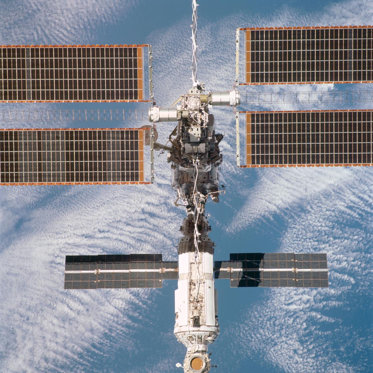
This video still depicts the recently deployed starboard and port solar arrays towering over the International Space Station (ISS). The video was recorded on STS-97's 65th orbit. Delivery, assembly, and activation of the solar arrays was the main mission objective of STS-97. The electrical power system, which is built into a 73-meter (240-foot) long solar array structure consists of solar arrays, radiators, batteries, and electronics, and will provide the power necessary for the first ISS crews to live and work in the U.S. segment. The entire 15.4-metric ton (17-ton) package is called the P6 Integrated Truss Segment, and is the heaviest and largest element yet delivered to the station aboard a space shuttle. The STS-97 crew of five launched aboard the Space Shuttle Orbiter Endeavor on November 30, 2000 for an 11 day mission.
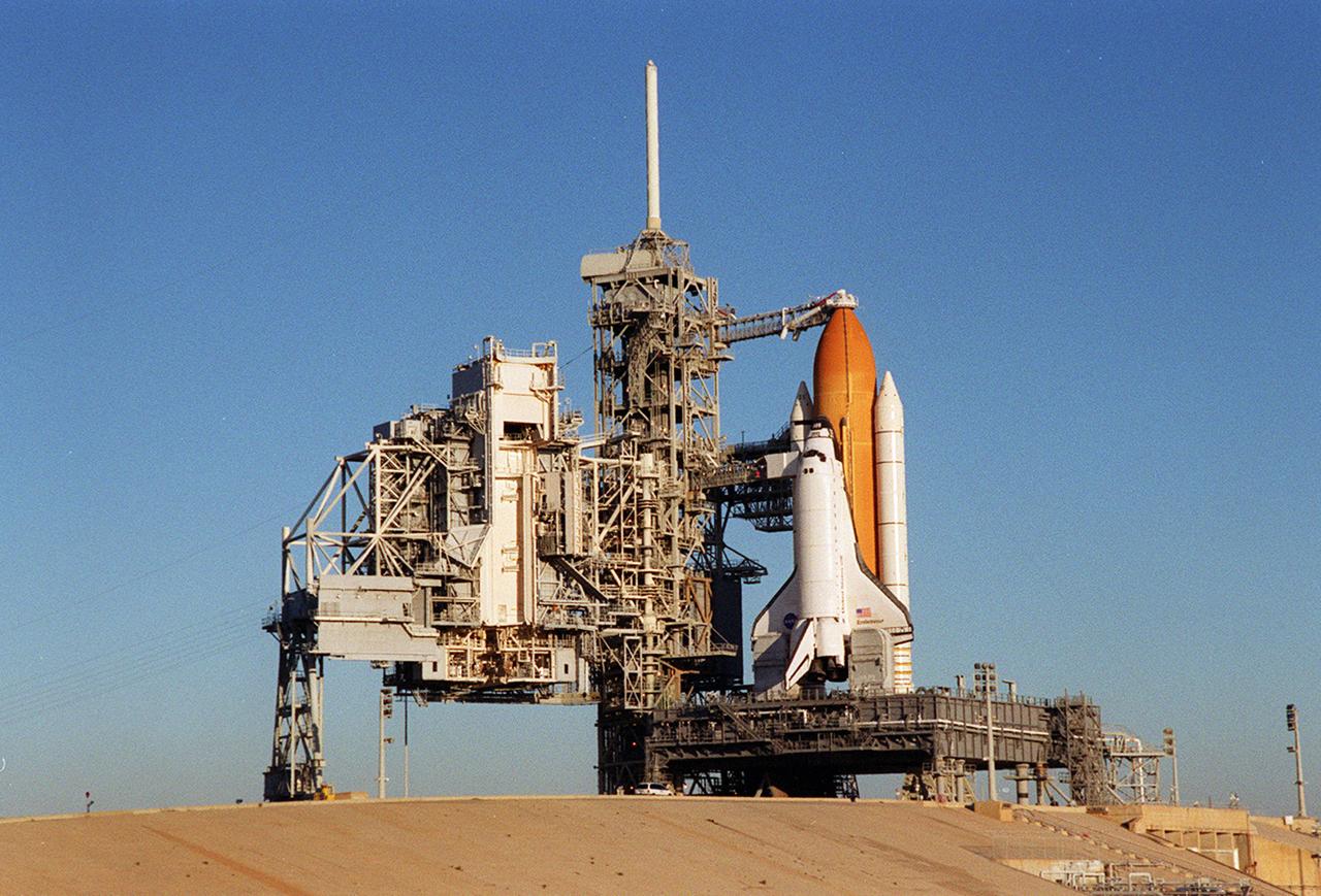
Back dropped by a cloudless blue sky, Space Shuttle Endeavor stands ready for launch after the rollback of the Rotating Service Structure, at left. The orbiter launched that night carrying the STS-97 crew of five. The STS-97 mission's primary objective was the delivery, assembly, and activation of the U.S. electrical power system onboard the International Space Station (ISS). The electrical power system, which is built into a 73-meter (240-foot) long solar array structure, consists of solar arrays, radiators, batteries, and electronics. The entire 15.4-metric ton (17-ton) package is called the P6 Integrated Truss Segment, and is the heaviest and largest element yet delivered to the station aboard a space shuttle. The electric system will eventually provide the power necessary for the first ISS crews to live and work in the U.S. segment.
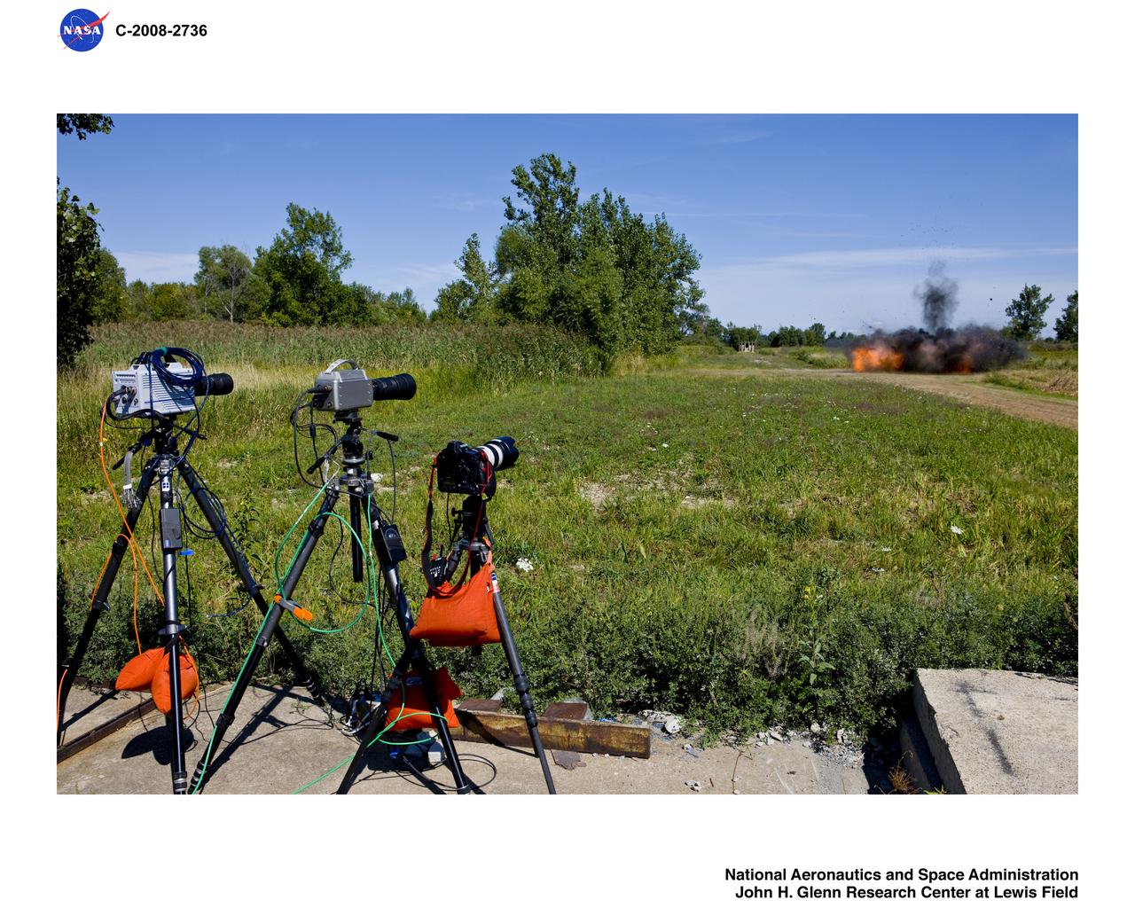
Documentation of explosives detonation at ARES of 10lbs. of C-4 Aerostat Video Program with 2 high speed cameras and digital still camera in foreground
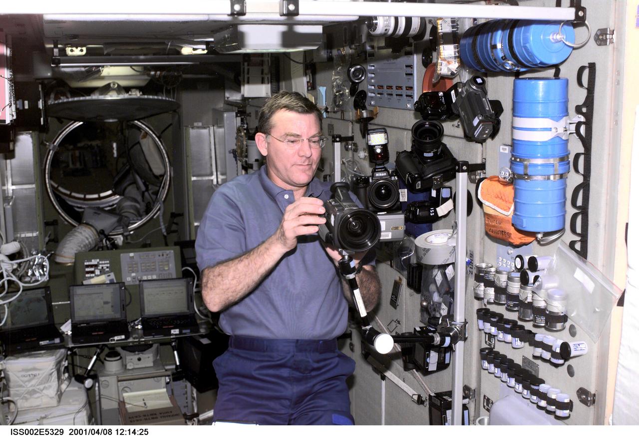
ISS002-E-5329 (08 April 2001) --- Astronaut James S. Voss, Expedition Two flight engineer, sets up a video camera on a mounting bracket in the Zvezda / Service Module of the International Space Station (ISS). A 35mm camera and a digital still camera are also visible nearby. This image was recorded with a digital still camera.
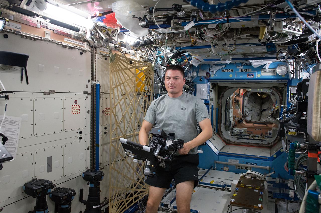
ISS045E028189 (09/24/2015 --- NASA astronaut Kjell Lindgren prepares to film with a RED Dragon camera, capable of capturing Ultra High-Definition (UHD) video. This new capability will allow researchers to acquire high resolution - high frame rate video to provide new insight into the vast array of experiments taking place every day. It will also bestow the most breathtaking views of planet Earth and space station activities ever acquired for consumption by those still dreaming of making the trip to outer space.
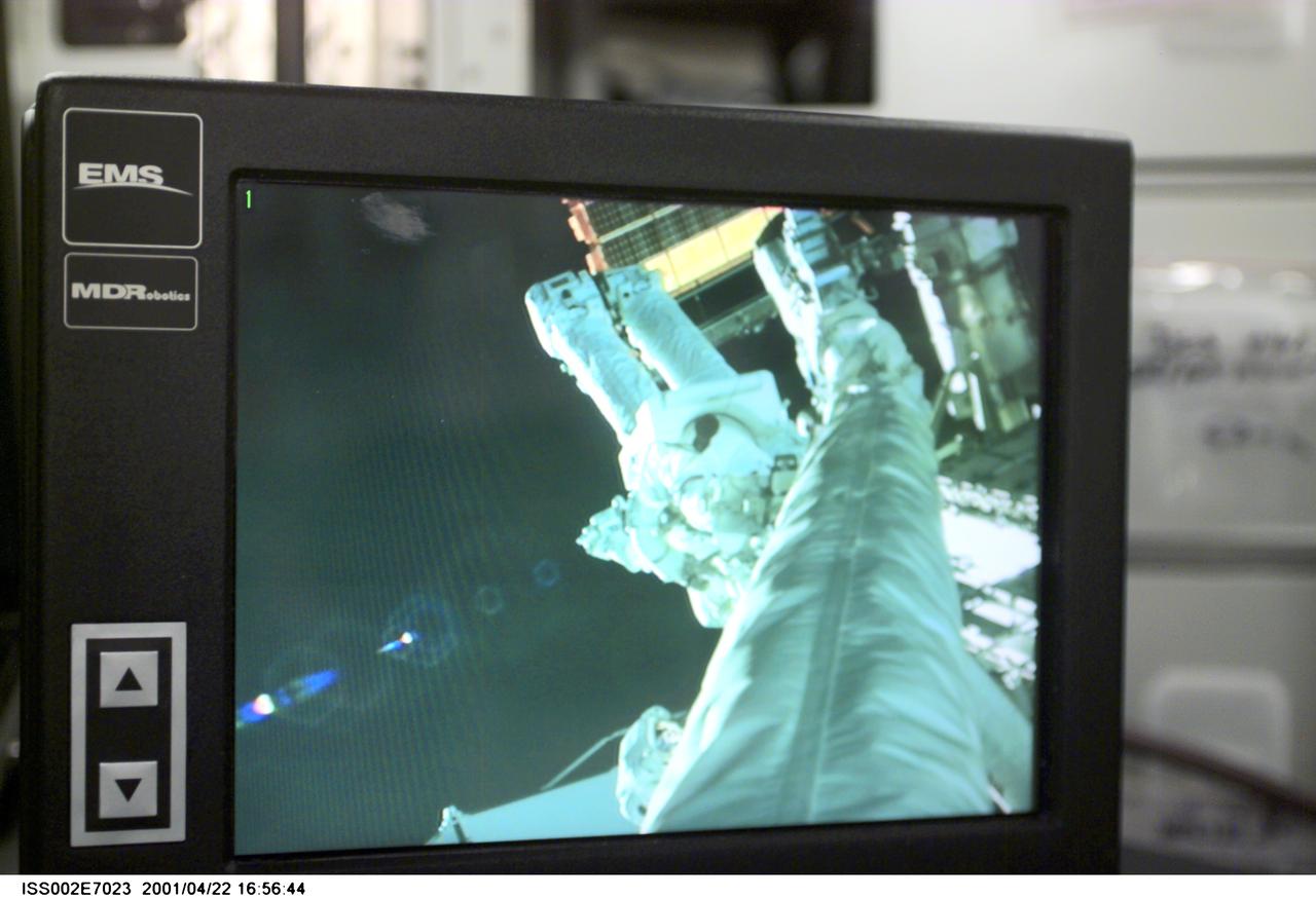
ISS002-E-7023 (22 April 2001) - Viewed on a monitor in the Destiny/U.S. Laboratory, Astronaut Chris A. Hadfield, STS-100 mission specialist representing the Canadian Space Agency (CSA), can be seen during the first space walk (EVA-1) of the STS-100 mission. The image on the monitor was taken with the Canadian-built Remote Manipulator System (RMS) arm video camera, and this still image was recorded with a digital still camera.
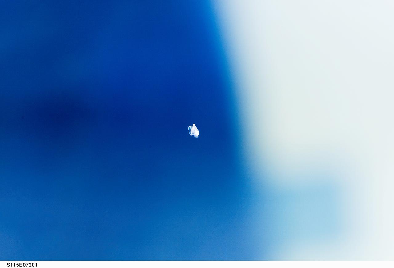
S115-E-07201 (19 Sept. 2006) --- This picture of unidentified possible small debris was recorded with a digital still camera by astronaut Daniel Burbank onboard the Space Shuttle Atlantis around 11 a.m. (CDT) today. Engineers do not believe this to be the same object seen in video taken by shuttle TV cameras earlier in the day.
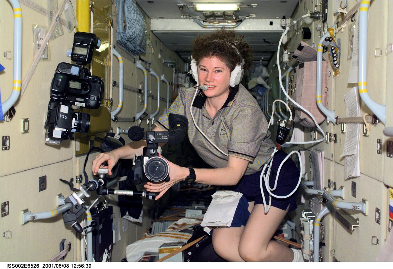
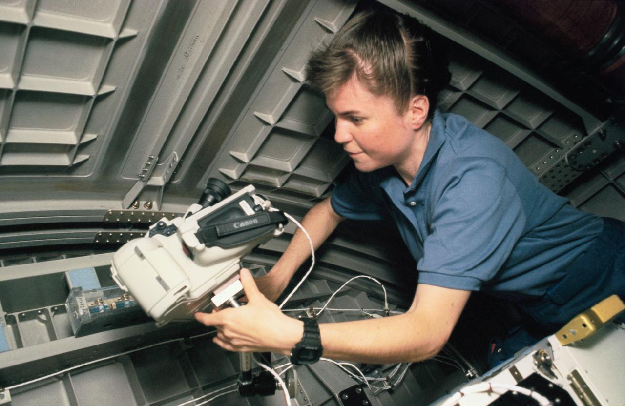
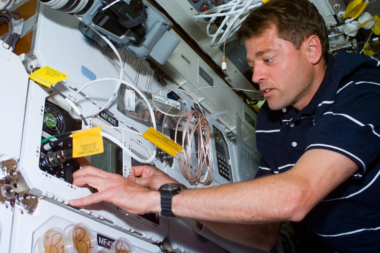
ISS002-E-6526 (8 June 2001) --- Astronaut Susan J. Helms, Expedition Two flight engineer, mounts a video camera onto a bracket in the Zarya or Functional Cargo Block (FGB) of the International Space Station (ISS). The image was recorded with a digital still camera. Alternate NASA ID of 0202499.

Two scientists at NASA Marshall Space Flight Center, atmospheric scientist Paul Meyer (left) and solar physicist Dr. David Hathaway, have developed promising new software, called Video Image Stabilization and Registration (VISAR), that may help law enforcement agencies to catch criminals by improving the quality of video recorded at crime scenes, VISAR stabilizes camera motion in the horizontal and vertical as well as rotation and zoom effects; produces clearer images of moving objects; smoothes jagged edges; enhances still images; and reduces video noise of snow. VISAR could also have applications in medical and meteorological imaging. It could steady images of Ultrasounds which are infamous for their grainy, blurred quality. It would be especially useful for tornadoes, tracking whirling objects and helping to determine the tornado's wind speed. This image shows two scientists reviewing an enhanced video image of a license plate taken from a moving automobile.
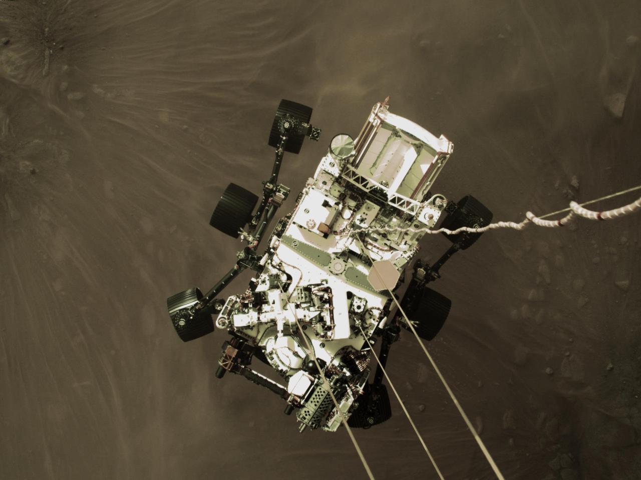
This high-resolution still image is part of a video taken by several cameras as NASA's Perseverance rover touched down on Mars on Feb. 18, 2021. A camera aboard the descent stage captured this shot. A key objective for Perseverance's mission on Mars is astrobiology, including the search for signs of ancient microbial life. The rover will characterize the planet's geology and past climate, pave the way for human exploration of the Red Planet, and be the first mission to collect and cache Martian rock and regolith (broken rock and dust). Subsequent NASA missions, in cooperation with ESA (the European Space Agency), would send spacecraft to Mars to collect these cached samples from the surface and return them to Earth for in-depth analysis. The Mars 2020 mission is part of a larger program that includes missions to the Moon as a way to prepare for human exploration of the Red Planet. https://photojournal.jpl.nasa.gov/catalog/PIA24428
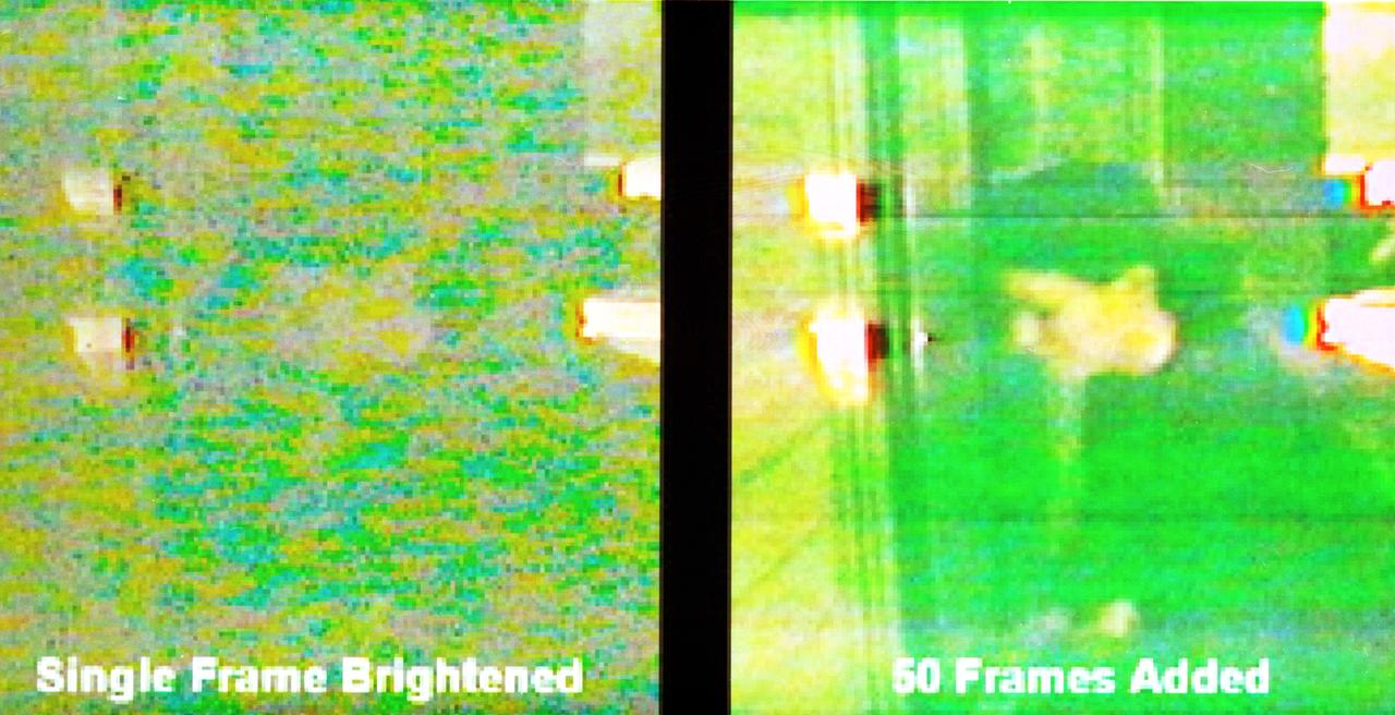
Two scientists at NASA's Marshall Space Flight Center,atmospheric scientist Paul Meyer and solar physicist Dr. David Hathaway, developed promising new software, called Video Image Stabilization and Registration (VISAR). VISAR may help law enforcement agencies catch criminals by improving the quality of video recorded at crime scenes. In this photograph, the single frame at left, taken at night, was brightened in order to enhance details and reduce noise or snow. To further overcome the video defects in one frame, Law enforcement officials can use VISAR software to add information from multiple frames to reveal a person. Images from less than a second of videotape were added together to create the clarified image at right. VISAR stabilizes camera motion in the horizontal and vertical as well as rotation and zoom effects producing clearer images of moving objects, smoothes jagged edges, enhances still images, and reduces video noise or snow. VISAR could also have applications in medical and meteorological imaging. It could steady images of ultrasounds, which are infamous for their grainy, blurred quality. The software can be used for defense application by improving recornaissance video imagery made by military vehicles, aircraft, and ships traveling in harsh, rugged environments.
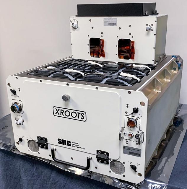
jsc2021e037285 (2/12/2021) --- A preflight view of the XROOTS hardware. The eXposed Root On-Orbit Test System (XROOTS) investigation uses hydroponic and aeroponic techniques to grow plants without soil or other growth media. Video and still images enable evaluation of multiple independent growth chambers for the entire plant life cycle from seed germination through maturity. Results could identify suitable methods to produce crops on a larger scale for future space missions.

Students from DuPont Manual High School in Louisville, Kentucky participated in a video-teleconference during the Pan-Pacific Basin Workshop on Microgravity Sciences held in Pasadena, California. The event originated at the California Science Center in Los Angeles. The DuPont Manual students patched in to the event through the distance learning lab at the Louisville Science Center. This image is from a digital still camera; higher resolution is not available.

The lone active region visible on the sun put on a fine display with its tangled magnetic field lines swaying and twisting above it (Apr. 24-26, 2018) when viewed in a wavelength of extreme ultraviolet light. The charged particles spinning along these field lines illuminate them. The region did not erupt with any significant solar storms, although it still might. Videos are available at https://photojournal.jpl.nasa.gov/catalog/PIA22449
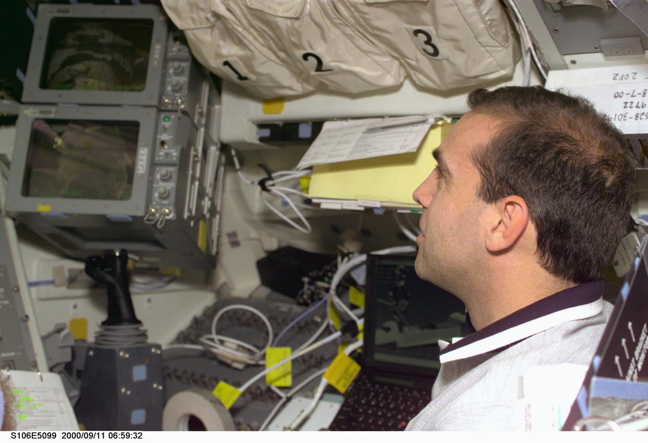
STS106-E-5099 (11 September 2000) --- Astronaut Richard A. Mastracchio, mission specialist, stands near viewing windows, video monitors and the controls for the remote manipulator system (RMS) arm (out of frame at left) on the flight deck of the Earth-orbiting Space Shuttle Atlantis during Flight Day 3 activity. Atlantis was docked with the International Space Station (ISS) when this photo was recorded with an electronic still camera (ESC).
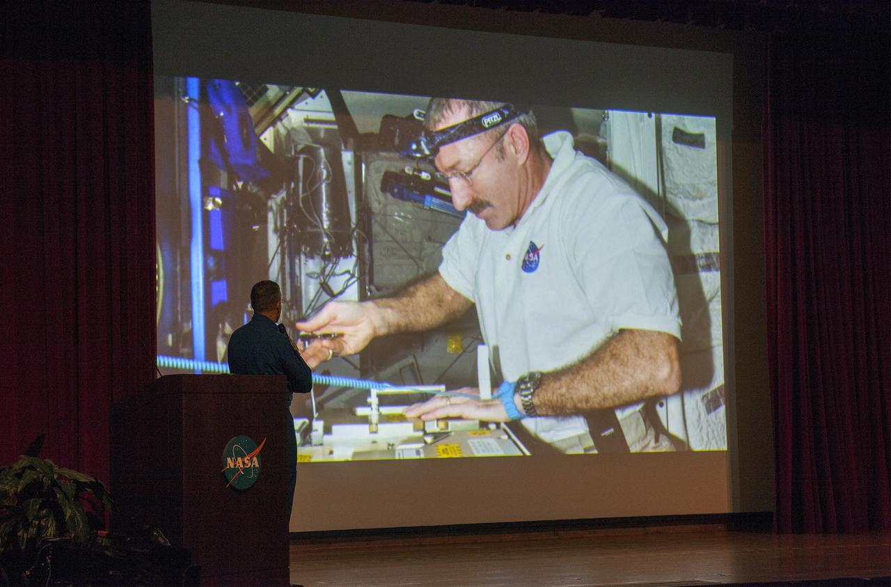
CAPE CANAVERAL, Fla. – NASA astronaut Dan Burbank, who served as commander of Expedition 30 aboard the International Space Station, reviews still and video imagery of life aboard the orbiting laboratory during his presentation to Kennedy Space Center employees. Burbank spent 165 days aboard the station during expeditions 29 and 30. For more information on the space station, visit http://www.nasa.gov/mission_pages/station/expeditions/index.html Photo credit: NASA/Kim Shiflett & Gianni Woods
STS105-E-5007 (10 August 2001) --- Cosmonaut Vladimir Dezhurov of Rosaviakosmos uses a video camcorder on the mid deck of the Space Shuttle Discovery during the first day in space for the STS-105 crew members and the Expedition Three crew. Dezhurov will serve as flight engineer aboard the International Space Station (ISS). This image was recorded with a digital still camera.
Marshall Space Flight Center employees visited DuPont Manual High School in Louisville, Kentucky. NASA's Mini Drop Tower was used to demonstrate free fall and a presentation was given on microgravity and the science performed in a microgravity environment. The visit coincided with the Pan-Pacific Basin Workshop on Microgravity Sciences held in Pasadena, California. Students watch the playback of video from the mini-drop tower. This image is from a digital still camera; higher resolution is not available.
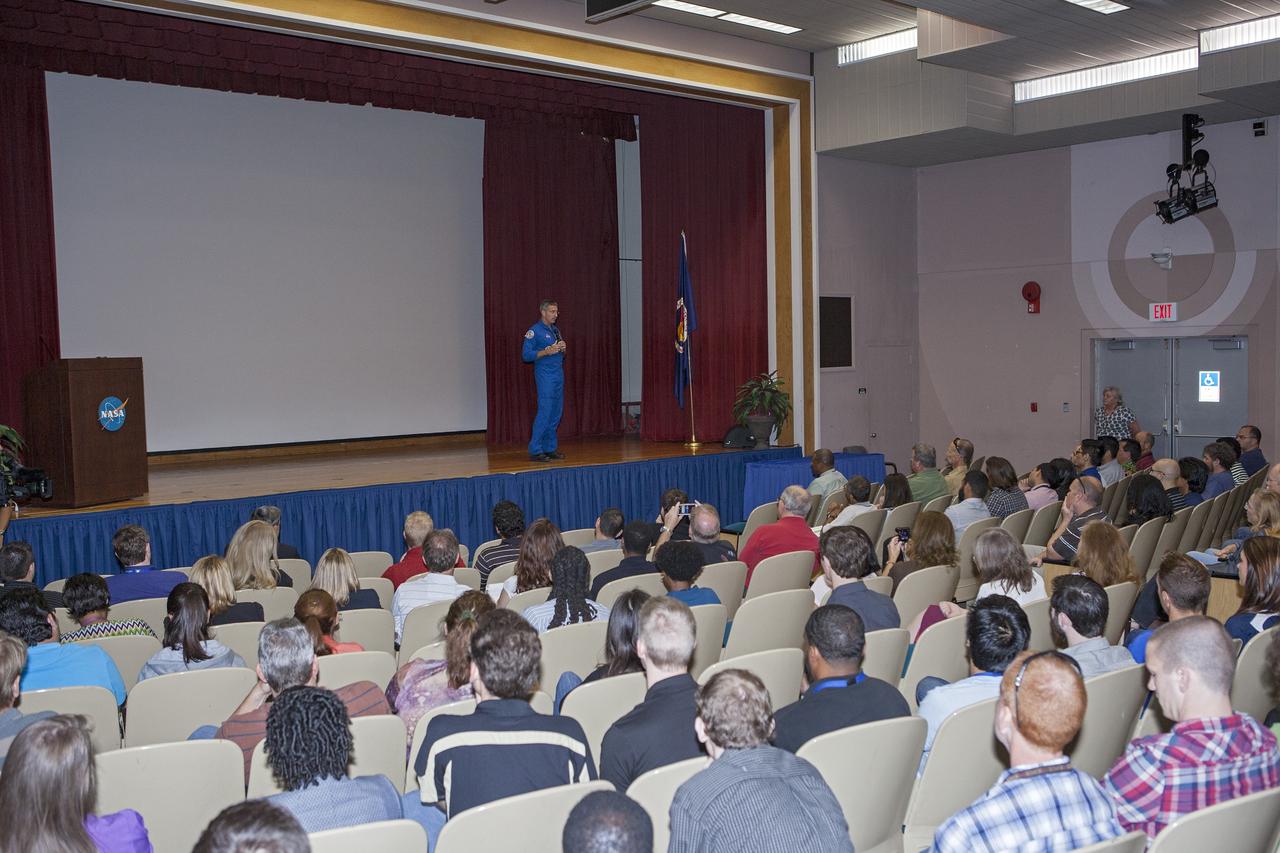
CAPE CANAVERAL, Fla. – NASA astronaut Dan Burbank, who served as commander of Expedition 30 aboard the International Space Station, reviews still and video imagery of life aboard the orbiting laboratory during his presentation to Kennedy Space Center employees. Burbank spent 165 days aboard the station during expeditions 29 and 30. For more information on the space station, visit http://www.nasa.gov/mission_pages/station/expeditions/index.html Photo credit: NASA/Kim Shiflett & Gianni Woods
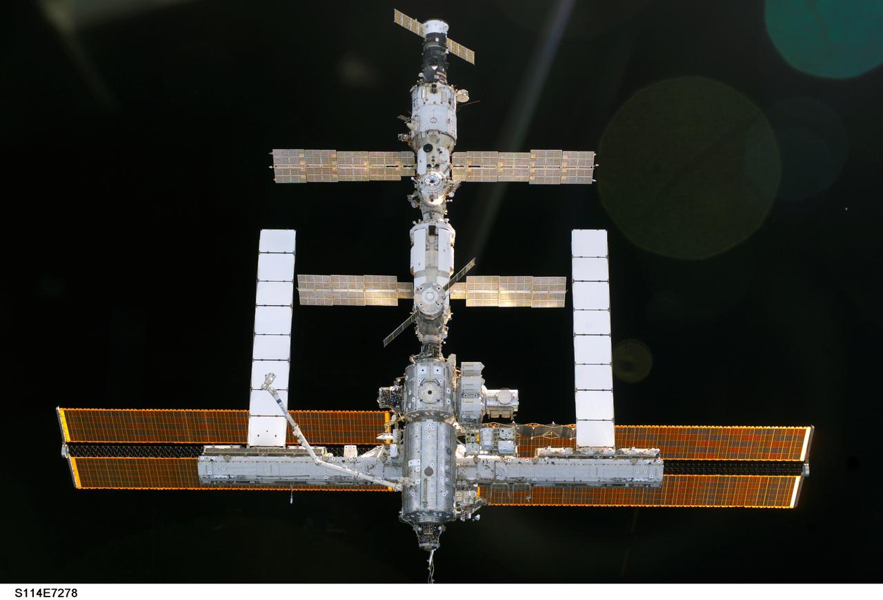
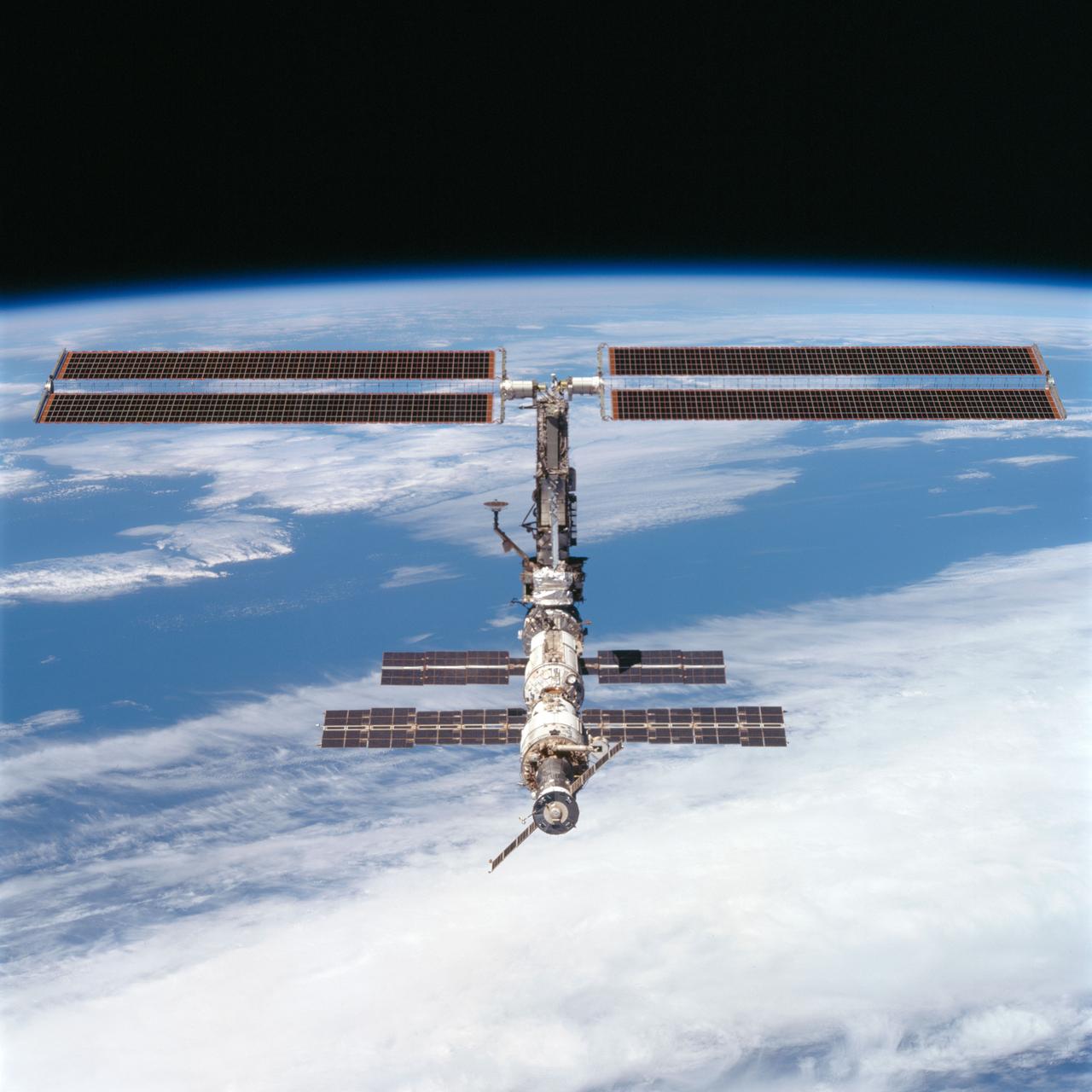
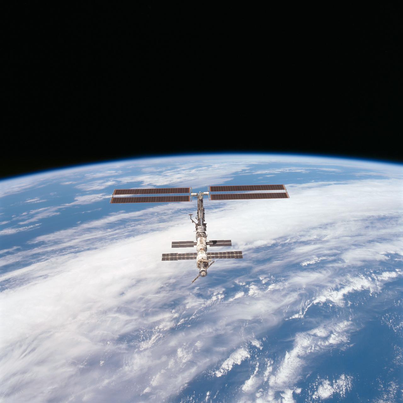
S114-E-7278 (6 August 2005) --- The International Space Station is backdropped against the blackness of space as the orbital outpost moves away from the Space Shuttle Discovery. Earlier, the crews of the two spacecraft concluded nine days of cooperative work. As the Shuttle moved away to a distance of about 400 feet, astronaut James M. Kelly, pilot, began a slow fly-around of the Station, as cameras on each spacecraft captured video and still images of the other. Undocking occurred at 2:24 a.m. (CDT), August 6, 2005.
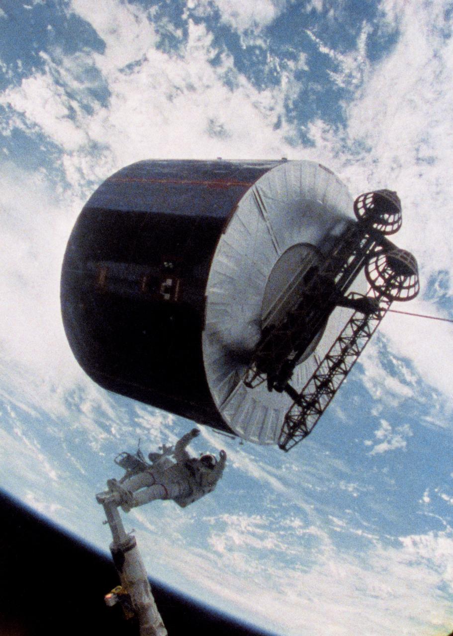
51I-S-237 (1 Sept. 1985) --- A still photo made from a video downlink shows astronaut James D. van Hoften, just after giving a shove to the Syncom IV-3 communications satellite. NASA's 51-I astronaut crew aboard the space shuttle Discovery had earlier captured and repaired the previously errant satellite. Photo credit: NASA
Students from DuPont Manual High School in Louisville, Kentucky participated in a video-teleconference during the Pan-Pacific Basin Workshop on Microgravity Sciences held in Pasadena, California. The event originated at the California Science Center in Los Angeles. The DuPont Manual students patched in to the event through the distance learning lab at the Louisville Science Center. This image is from a digital still camera; higher resolution is not available.
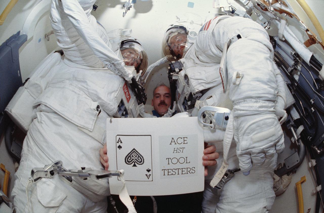
STS051-66-009 (16 Sept 1993) --- In Discovery's airlock, astronaut William F. Readdy, pilot, holds up a STS-51 slogan -- "Ace HST Tool Testers" -- for still and video cameras to record. Readdy is flanked by astronauts Carl E. Walz (left) and James H. Newman, who had just shared a lengthy period of extravehicular activity (EVA) in and around Discovery's cargo bay. Not pictured are astronauts Frank L. Culbertson Jr., mission commander, and Daniel W. Bursch, mission specialist.

CAPE CANAVERAL, Fla. – NASA astronaut Dan Burbank, who served as commander of Expedition 30 aboard the International Space Station, reviews still and video imagery of life aboard the orbiting laboratory during his presentation to Kennedy Space Center employees. Burbank spent 165 days aboard the station during expeditions 29 and 30. For more information on the space station, visit http://www.nasa.gov/mission_pages/station/expeditions/index.html Photo credit: NASA/Kim Shiflett & Gianni Woods

Students from DuPont Manual High School in Louisville, Kentucky participated in a video-teleconference during the Pan-Pacific Basin Workshop on Microgravity Sciences held in Pasadena, California. The event originated at the California Science Center in Los Angeles. The DuPont Manual students patched in to the event through the distance learning lab at the Louisville Science Center. Education coordinator Twila Schneider (left) of Infinity Technology and NASA materials engineer Chris Cochrane prepare students for the on-line workshop. This image is from a digital still camera; higher resolution is not available.
STS100-342-035 (19 April-1 May 2001) --- Astronaut John L. Phillips, mission specialist, works with the IMAX camera on the International Space Station (ISS). Phillips and his STS-100 crew mates transferred supplies to the station and recorded video, motion picture and still photography of their activities, including interaction with the Expedition Two crewmembers.

STS-105-E-5097 (12 August 2001) --- Expedition Two, Expedition Three and STS-105 crewmembers work with some video equipment in the U.S. Laboratory. From left to right are: cosmonaut Yury V. Usachev, Expedition Two mission commander; Daniel T. Barry, STS-105 mission specialist; Scott J. Horowitz, STS-105 commander - holding a camcorder; James S. Voss, Expedition Two flight engineer - holding a high definition video camera; cosmonaut Vladimir N. Dezhurov, Expedition Three flight engineer; Frank L. Culbertson, Expedition Three mission commander; and Patrick G. Forrester, STS-100 mission specialist. This image was taken with a digital still camera.
STS-105-E-5132 (12 August 2001) --- Expedition Three and STS-105 crewmembers get familiar with the Zvezda Service Module during the initial ingress into the International Space Station (ISS) for the STS-105 mission. Clockwise from the top left are: cosmonaut Mikhail Tyurin, Expedition Three flight engineer; cosmonaut Vladimir N. Dezhurov (using a high definition video camera), Expedition Three flight engineer; Scott J. Horowitz, STS-105 commander; and Daniel T. Barry, STS-105 mission specialist. This image was taken with a digital still camera.

This still image from an animation from NASA GSFC Solar Dynamics Observatory shows magnetically charged particles forming a nicely symmetrical arch at the edge of the Sun as they followed the magnetic field lines of an active region Aug.4-5, 2015. Before long the arch begins to fade, but a fainter and taller arch appears for a time in the same place. Note that several other bright active regions display similar kinds of loops above them. These images of ionized iron at about one million degrees were taken in a wavelength of extreme ultraviolet light. The video covers about 30 hours of activity. http://photojournal.jpl.nasa.gov/catalog/PIA19874
STS-105-E-5103 (12 August 2001) --- Yury V. Usachev of Rosiaviakosmos (left), Expedition Two mission commander, addresses the visiting STS-105 and Expedition Three crews in the U.S. Laboratory. Also visible, from left to right, are Daniel T. Barry, STS-105 mission specialist, James S. Voss, Expedition Two flight engineer, Scott J. Horowitz, STS-105 commander - holding a camcorder, cosmonaut Vladimir N. Dezhurov, Expedition Three flight engineer - holding a high definition video camera. This image was taken with a digital still camera.
STS063-313-018 (3-11 Feb 1995) --- Janice E. Voss, mission specialist, with a video camera in SpaceHab-3 onboard the Space Shuttle Discovery. This is one of 16 still photographs released by the NASA Johnson Space Center (JSC) Public Affairs Office (PAO) on February 14, 1995. Others onboard the Discovery were astronauts James D. Wetherbee, mission commander; Eileen M. Collins, pilot; Bernard A. Harris Jr., payload commander; mission specialists C. Michael Foale, and cosmonaut Vladimir G. Titov.
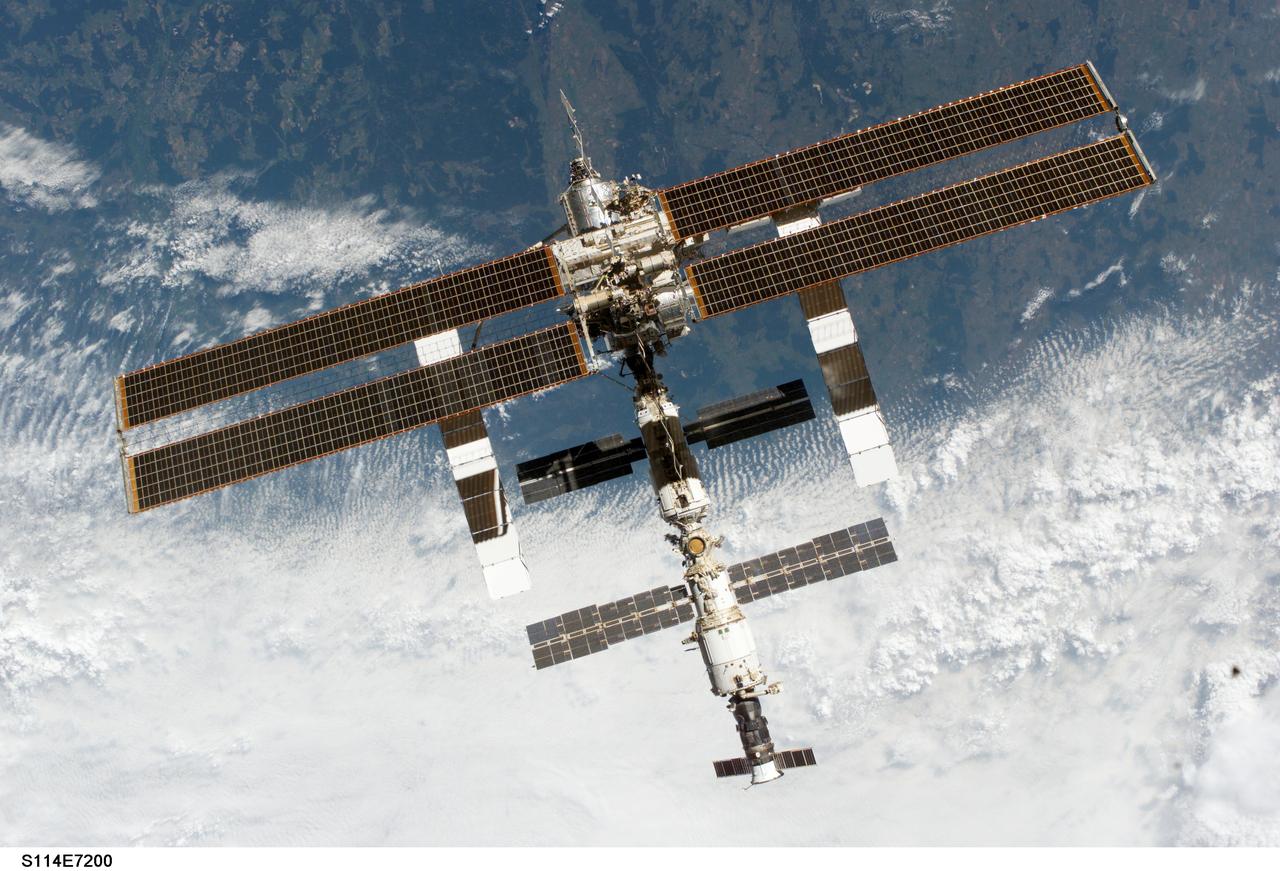
S114-E-7200 (6 August 2005) --- The International Space Station is backdropped against a heavily cloud-covered part of Earth as the orbital outpost moves away from the Space Shuttle Discovery. Earlier, the crews of the two spacecraft concluded nine days of cooperative work. As the Shuttle moved away to a distance of about 400 feet, astronaut James M. Kelly, pilot, began a slow fly-around of the Station, while cameras on each spacecraft captured video and still images of the other. Undocking occurred at 2:24 a.m. (CDT), August 6, 2005.
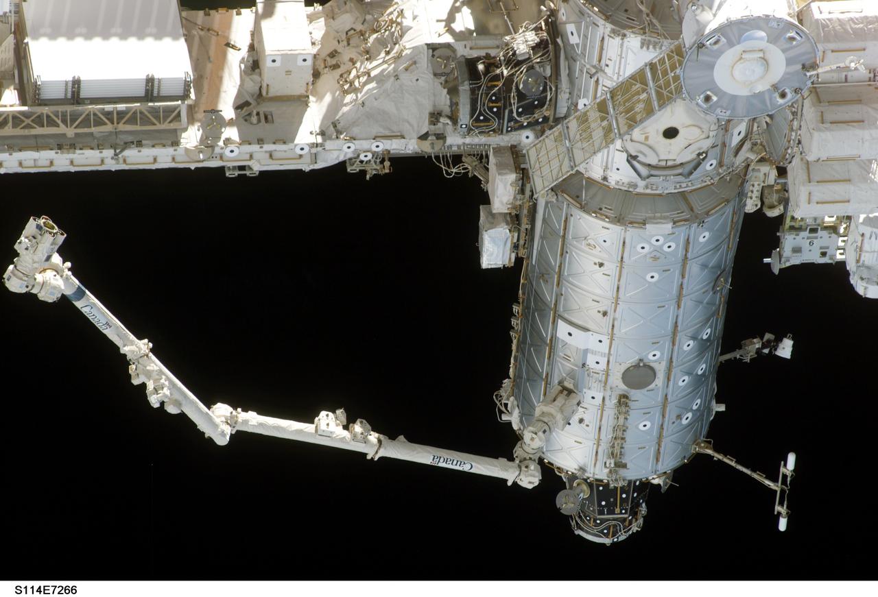
S114-E-7266 (6 August 2005) --- The Space Station Remote Manipulator System arm or Canadarm2 appears to be waving good bye to the Space Shuttle as the orbital outpost moves away from Discovery. Earlier, the crews of the two spacecraft concluded nine days of cooperative work. As the Shuttle moved away to a distance of about 400 feet, astronaut James M. Kelly, pilot, began a slow fly-around of the Station, while cameras on each spacecraft captured video and still images of the other. Undocking occurred at 2:24 a.m. (CDT), August 6, 2005.

STS076-315-003 (22-31 March 1996) --- Onboard the aft flight deck of the Earth-orbiting space shuttle Atlantis, astronaut Richard A. Searfoss, pilot, signals approval of progress with the KidSat Project - a three year pilot program making its first flight in space. KidSat is to fly on the Space Shuttle once a year. An Electronic Still Camera (ESC) (upper right), aimed at Earth below, was controlled by students on the ground during the flight. A video camera (out of frame) was also utilized. The downlinked images are to be used as a basis for a broad scope of curriculum disciplines.
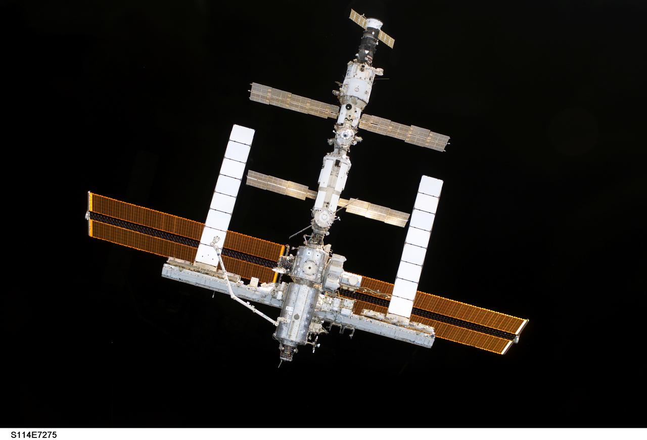
S114-E-7275 (6 August 2005) --- The International Space Station is backdropped against blackness of space as the orbital outpost moves away from the Space Shuttle Discovery. Earlier, the crews of the two spacecraft concluded nine days of cooperative work. As the Shuttle moved away to a distance of about 400 feet, astronaut James M. Kelly, pilot, began a slow fly-around of the Station, while cameras on each spacecraft captured video and still images of the other. Undocking occurred at 2:24 a.m. (CDT), August 6, 2005.
NASA's Curiosity Mars rover recorded two 25-frame videos showing the passage of 12 hours on Nov. 8, 2023, the 4,002nd Martian day, or sol, of the mission. The commands to capture the images that make up these videos were among the last that engineers beamed up to the rover before the start of Mars solar conjunction – a period of several weeks when the Sun is between Earth and Mars. Because the Sun's plasma can interfere with radio communications, NASA's Mars missions stand down from sending commands to their spacecraft during conjunction, bringing the missions to a temporary standstill. (The spacecraft still radio back their health status during this period.) The images were captured with Curiosity's front and rear Hazard-Avoidance Cameras, or Hazcams. Rover drivers use these black-and-white cameras to plan safe drive routes. A long series of images can be put together to create a video so that scientists can look for passing clouds or dust devils, which teach them more about the Martian environment. The perfect time for doing this type of work is when Curiosity is less active for long stretches, as it was during Mars solar conjunction. The lack of robotic arm motion and driving during conjunction allowed the Hazcams to image for 12 hours of a day – from 5:30 a.m. to 5:30 p.m. local Mars time – for the first time. While these Hazcam videos didn't reveal any clouds or dust activity, they did capture the passage of time as the Sun rose and set. The main video shows the front Hazcam's view looking southeast along Gediz Vallis, a valley found on Mount Sharp, the base of which Curiosity has been ascending since 2014. The sky brightens during sunrise in the east (left of image), and the shadow of the rover's stationary 7-foot (2-meter) robotic arm moves across the ground like that of a sundial. The rover's two front wheels are visible on each side of the frame; at upper left is a circular calibration target mounted on the shoulder of the robotic arm. Engineers use the target to test the accuracy of the Alpha Particle X-ray Spectrometer, an instrument that detects chemical elements on the Martian surface. In the middle of the day, the camera's autoexposure algorithm settles on exposure times of around one-third of a second; as evening turns to night, that exposure time grows to more than a minute, causing typical sensor noise known as "hot pixels" that appear as snow across the final image. Video available at https://photojournal.jpl.nasa.gov/catalog/PIA26209

This still from a video shows illustrations of the seven Earth-size planets of TRAPPIST-1, an exoplanet system about 40 light-years away, based on data current as of February 2018. Each planet is shown in sequence, starting with the innermost TRAPPIST-1b and ending with the outermost TRAPPIST-1h. The video presents the planets' relative sizes as well as the relative scale of the central star as seen from each planet. The art highlights possibilities for how the surfaces of these intriguing worlds might look based on their newly calculated properties. The seven planets of TRAPPIST-1 are all Earth-sized and terrestrial. TRAPPIST-1 is an ultra-cool dwarf star in the constellation Aquarius, and its planets orbit very close to it. In the background, slightly distorted versions our familiar constellations, including Orion and Taurus, are shown as they would appear from the location of TRAPPIST-1 (backdrop image courtesy California Academy of Sciences/Dan Tell). An animation is available at https://photojournal.jpl.nasa.gov/catalog/PIA22098
S93-E-5003 (23 July 1999) --- Astronaut Jeffrey S. Ashby, pilot, works at the Space Tissue Loss-B experiment on Space Shuttle Columbia's middeck. The experiment is set up to observe cells in culture with a video microscope imaging system to record near-real-time interactions of detecting and inducing cellular responses (macromorphological changes). Just above and to the right of STL-B is the part of the Commercial Generic Bioprocessing Apparatus (CGBA) for the National Institute of Health (NIH-B experiment). It is an experiment designed to investigate the effects of space flight on neural development in Drosophila melanogaster (fruit fly) larvae. This information may help scientists understand how gravity affects nerve growth and development and how neural connections to muscle fibers work. The photo was recorded with an electronic still camera (ESC) on Flight Day 1. Ashby and his four crew mates are scheduled to spend five days aboard Columbia in Earth orbit.
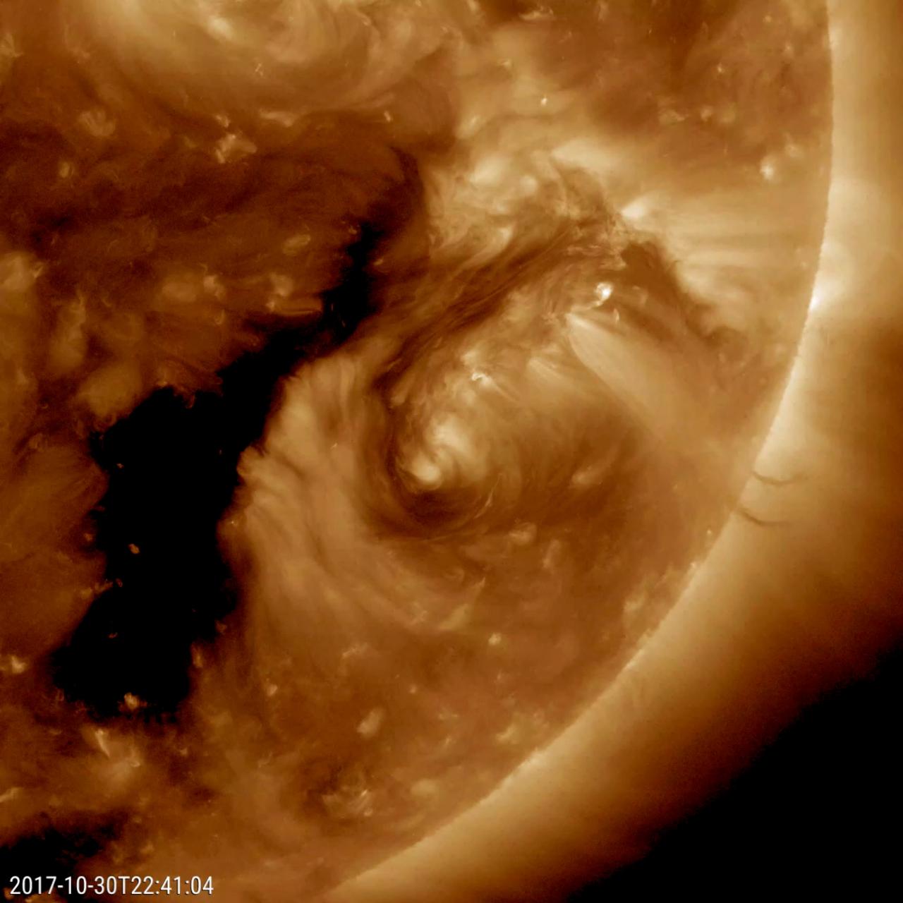
NASA's Solar Dynamics Observatory came across an oddity this week that the spacecraft has rarely observed before: a dark filament encircling an active region (Oct. 29-31, 2017). Solar filaments are clouds of charged particles that float above the sun, tethered to it by magnetic forces. They are usually elongated and uneven strands. Only a handful of times before have we seen one shaped like a circle. (The black area to the left of the brighter active region is a coronal hole, a magnetically open region of the sun). While it may no major scientific value, it is noteworthy because of its rarity. The still and video clip were taken in a wavelength of extreme ultraviolet light. Movies are available at https://photojournal.jpl.nasa.gov/catalog/PIA22104
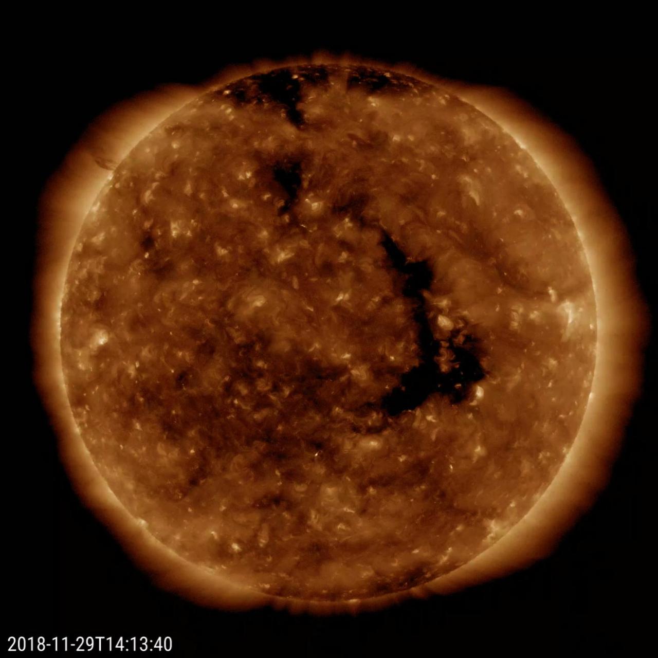
A long-lasting coronal hole has again rotated around to face the Earth (Nov. 28-30, 2018). This persistent hole - the elongated dark region seen in the still image - first appeared in July and has been observed each rotation of the Sun since. Coronal holes are the source of high-speed solar wind; when this one faced Earth, it sparked outbursts of aurora some of which were observed in our northern tier states. Coronal holes are magnetically open regions on the Sun that can last from days to months, although this one has lasted longer than most. The time-lapse video, taken in a wavelength of extreme ultraviolet light, covers about two days of activity. Movies available at https://photojournal.jpl.nasa.gov/catalog/PIA18144
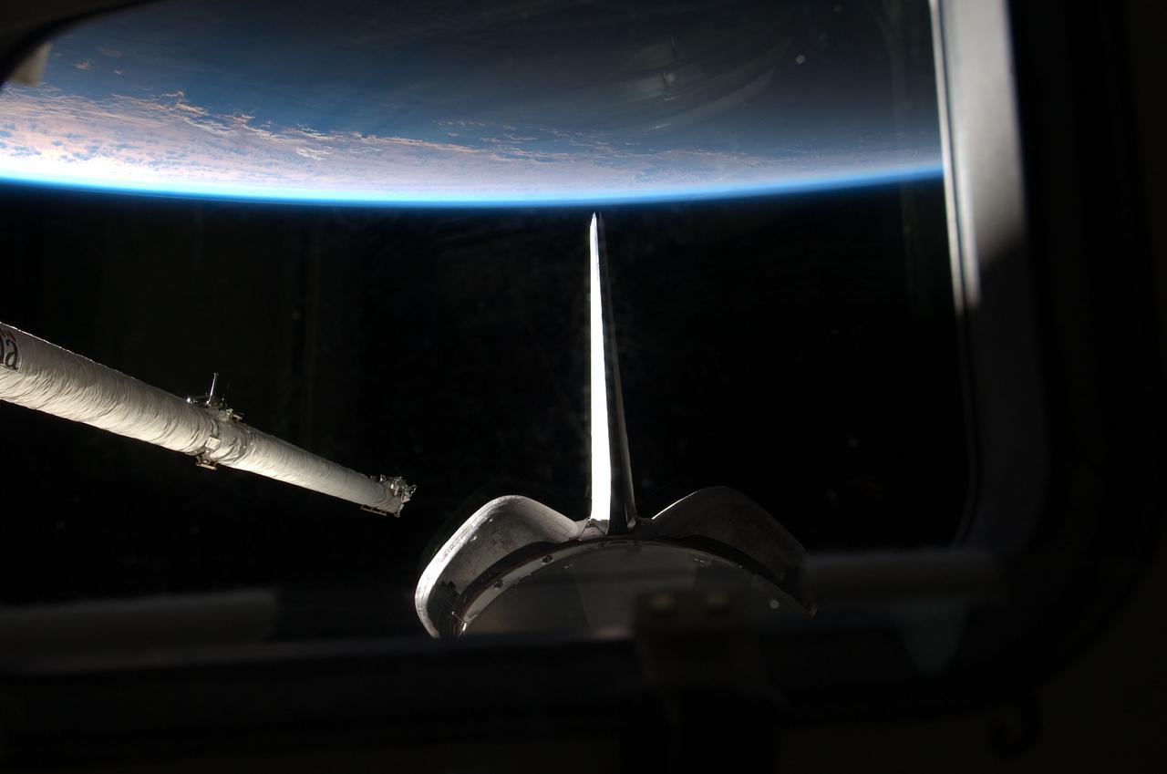
S135-E-006361 (9 July 2011) --- One of the four STS-135 crewmembers took this photo from space shuttle Atlantis' aft flight deck during the mission's second day of activities in Earth orbit. Earth's horizon and aft sections of the shuttle frame the orbiter boom sensor system (OBSS) on the starboard side of the spacecraft shortly before it was remotely maneuvered into position to start survey of the spacecraft's thermal protection system (TPS). The various sensor packages on the OBSS, which include a high-resolution still camera, a laser range imager and a video camera, later swept over the critical surfaces of the TPS, looking for signs of any damage that might have been caused by ascent debris or anything that might endanger the shuttle's ability to return to Earth safely. Photo credit: NASA
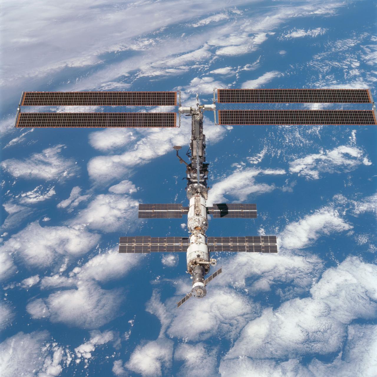
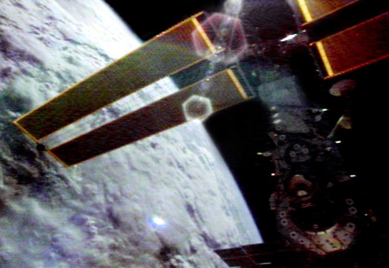
STS097-704-071 (9 December 2000) --- This picture is one of a series of 70mm frames exposed of the International Space Station (ISS) following undocking at 1:13 p.m. (CST), December 9, 2000. This series of images, as well as video and digital still imagery taken at the same time, represent the first imagery of the entire station with its new solar array panels deployed. Before separation, the shuttle and space station had been docked to one another for 6 days, 23 hours and 13 minutes. Endeavour moved downward from the space station, then began a tail-first circle at a distance of about 500 feet. The maneuver, with pilot Michael J. Bloomfield at the controls, took about an hour. While Endeavour flew that circle, the two spacecraft, moving at five miles a second, navigated about two-thirds of the way around the Earth. Undocking took place 235 statute miles above the border of Kazakhstan and China. When Endeavour made its final separation burn, the orbiter and the space station were near the northeastern coast of South America.
STS097-704-063 (9 December 2000) --- This overhead view is one of a series of 70mm frames exposed of the International Space Station (ISS) following undocking at 1:13 p.m. (CST), December 9, 2000. This series of images, as well as video and digital still imagery taken at the same time, represent the first imagery of the entire station with its new solar array panels deployed. Before separation, the shuttle and space station had been docked to one another for 6 days, 23 hours and 13 minutes. Endeavour moved downward from the space station, then began a tail-first circle at a distance of about 500 feet. The maneuver, with pilot Michael J. Bloomfield at the controls, took about an hour. While Endeavour flew that circle, the two spacecraft, moving at five miles a second, navigated about two-thirds of the way around the Earth. Undocking took place 235 statute miles above the border of Kazakhstan and China. When Endeavour made its final separation burn, the orbiter and the space station were near the northeastern coast of South America.
STS097-703-037 (9 December 2000) --- This picture is one of a series of 70mm frames exposed of the International Space Station (ISS) following undocking at 1:13 p.m. (CST), December 9, 2000. This series of images, as well as video and digital still imagery taken at the same time, represent the first imagery of the entire station with its new solar array panels deployed. Before separation, the shuttle and space station had been docked to one another for 6 days, 23 hours and 13 minutes. Endeavour moved downward from the space station, then began a tail-first circle at a distance of about 500 feet. The maneuver, with pilot Michael J. Bloomfield at the controls, took about an hour. While Endeavour flew that circle, the two spacecraft, moving at five miles a second, navigated about two-thirds of the way around the Earth. Undocking took place 235 statute miles above the border of Kazakhstan and China. When Endeavour made its final separation burn, the orbiter and the space station were near the northeastern coast of South America.
NASA's SPHEREx observatory will map the entire sky to help scientists answer big-picture questions about the origins of our universe, galaxies, and key ingredients for life in our galaxy, such as water. Operating from low Earth orbit, the telescope will sweep across the sky, taking about 600 exposures each day. Using a technique called spectroscopy, the observatory will image every section of the sky 102 times, each time using a different color filter that blocks all wavelengths except one. By combining those images, the mission will produce a map containing information about the composition of and distance to millions of stars and other objects in our galaxy and hundreds of millions of galaxies beyond. (See an animation of this process, depicted in a still artist's concept above, at spherex.caltech.edu/video/all-sky-survey.) Short for Spectro-Photometer for the History of the Universe, Epoch of Reionization and Ices Explorer, SPHEREx will help scientists study what happened in the first fraction of a second after the big bang, how galaxies formed and evolved, and the origins of water in planetary systems in our galaxy. https://photojournal.jpl.nasa.gov/catalog/PIA26533
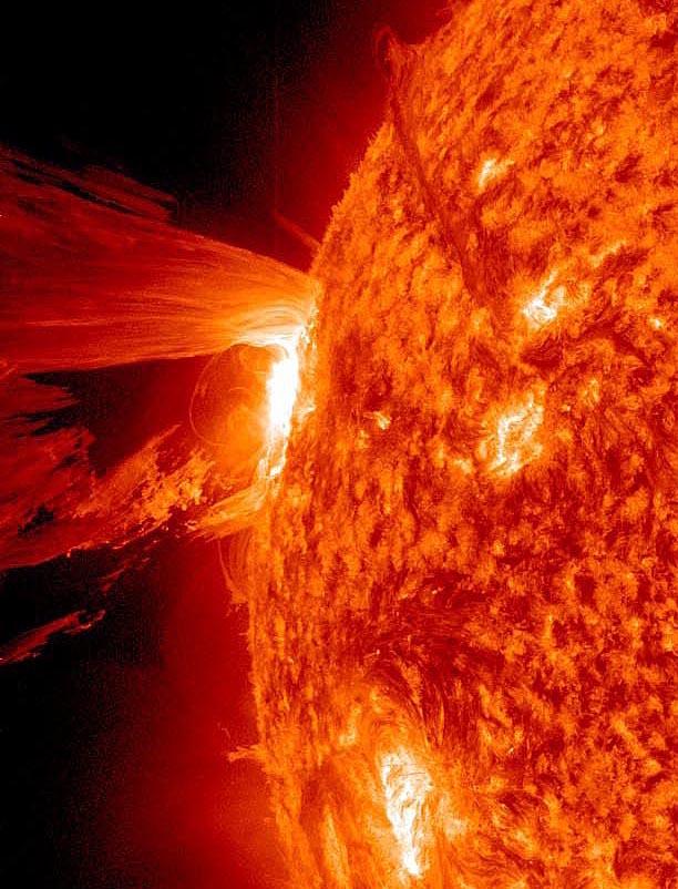
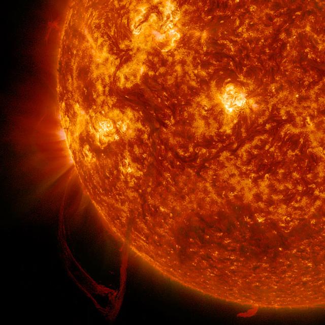
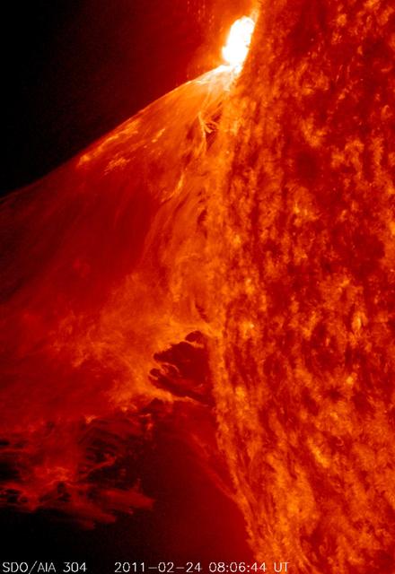
A beautiful prominence eruption shot off the east limb (left side) of the sun on Monday, April 16, 2012. Such eruptions are often associated with solar flares, and in this case an M1 class (medium-sized) flare did occur at the same time, though it was not aimed toward Earth. This event, which is still in progress, was seen by NASA’s SDO satellite. <b>View a video of this event here: <a href="http://www.flickr.com/photos/gsfc/7084820027">www.flickr.com/photos/gsfc/7084820027</a></b> Credit: NASA/GSFC/SDO <b><a href="http://www.nasa.gov/audience/formedia/features/MP_Photo_Guidelines.html" rel="nofollow">NASA image use policy.</a></b> <b><a href="http://www.nasa.gov/centers/goddard/home/index.html" rel="nofollow">NASA Goddard Space Flight Center</a></b> enables NASA’s mission through four scientific endeavors: Earth Science, Heliophysics, Solar System Exploration, and Astrophysics. Goddard plays a leading role in NASA’s accomplishments by contributing compelling scientific knowledge to advance the Agency’s mission. <b>Follow us on <a href="http://twitter.com/NASA_GoddardPix" rel="nofollow">Twitter</a></b> <b>Like us on <a href="http://www.facebook.com/pages/Greenbelt-MD/NASA-Goddard/395013845897?ref=tsd" rel="nofollow">Facebook</a></b> <b>Find us on <a href="http://instagrid.me/nasagoddard/?vm=grid" rel="nofollow">Instagram</a></b>
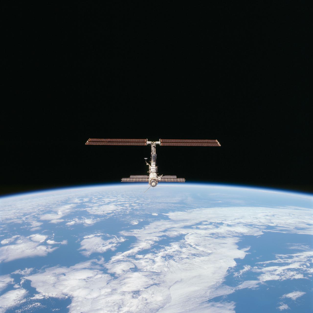
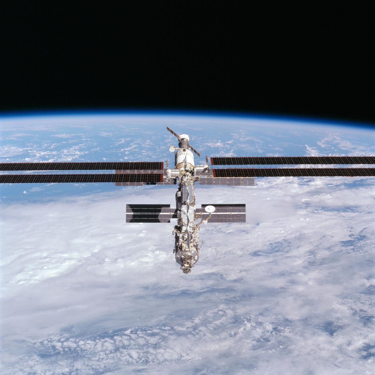
STS097-712-004 (9 December 2000) --- This picture of the distant International Space Station (ISS) blended against the darkness of space and the blue Earth at its horizon is one of a series of 70mm frames exposed of the station following undocking at 1:13 p.m. (CST), December 9, 2000. This series of images, as well as video and digital still imagery taken at the same time, represent the first imagery of the entire station with its new solar array panels deployed, though they are difficult to see in this angle. Before separation, the shuttle and space station had been docked to one another for 6 days, 23 hours and 13 minutes. Endeavour moved downward from the space station, then began a tail-first circle at a distance of about 500 feet. The maneuver, with pilot Michael J. Bloomfield at the controls, took about an hour. While Endeavour flew that circle, the two spacecraft, moving at five miles a second, navigated about two-thirds of the way around the Earth. Undocking took place 235 statute miles above the border of Kazakhstan and China. When Endeavour made its final separation burn, the orbiter and the space station were near the northeastern coast of South America.
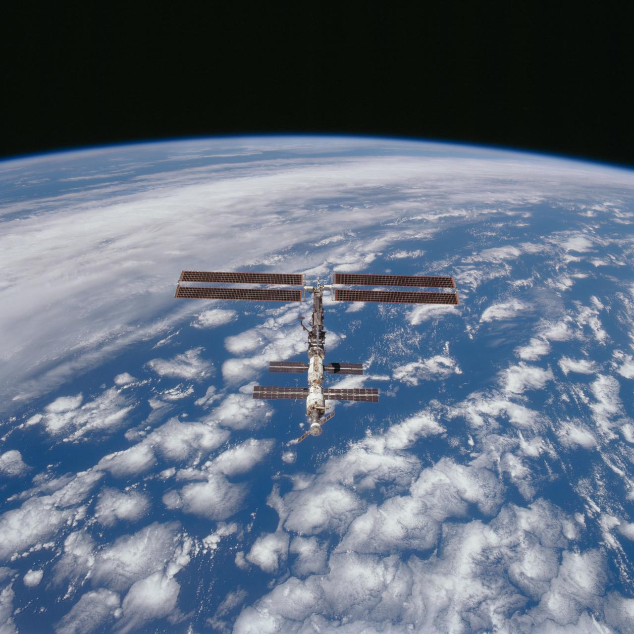
STS097-703-085 (9 December 2000) --- This picture is one of a series of 70mm frames exposed of the International Space Station (ISS) following undocking at 1:13 p.m. (CST), December 9, 2000. This series of images, as well as video and digital still imagery taken at the same time, represent the first imagery of the entire station with its new solar array panels deployed. Before separation, the shuttle and space station had been docked to one another for 6 days, 23 hours and 13 minutes. Endeavour moved downward from the space station, then began a tail-first circle at a distance of about 500 feet. The maneuver, with pilot Michael J. Bloomfield at the controls, took about an hour. While Endeavour flew that circle, the two spacecraft, moving at five miles a second, navigated about two-thirds of the way around the Earth. Undocking took place 235 statute miles above the border of Kazakhstan and China. When Endeavour made its final separation burn, the orbiter and the space station were near the northeastern coast of South America.
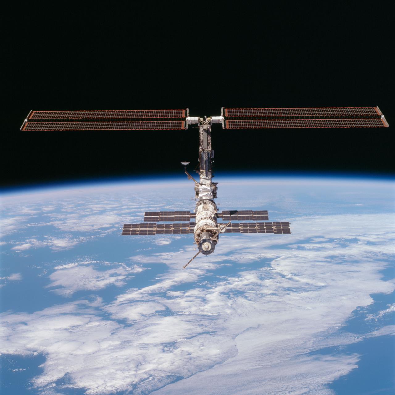
STS097-704-090 (9 December 2000) --- This picture of the distant International Space Station (ISS) blended against the darkness of space and the blue Earth at its horizon is one of a series of 70mm frames exposed of the station following undocking at 1:13 p.m. (CST), December 9, 2000. This series of images, as well as video and digital still imagery taken at the same time, represent the first imagery of the entire station with its new solar array panels deployed. Before separation, the shuttle and space station had been docked to one another for 6 days, 23 hours and 13 minutes. Endeavour moved downward from the space station, then began a tail-first circle at a distance of about 500 feet. The maneuver, with pilot Michael J. Bloomfield at the controls, took about an hour. While Endeavour flew that circle, the two spacecraft, moving at five miles a second, navigated about two-thirds of the way around the Earth. Undocking took place 235 statute miles above the border of Kazakhstan and China. When Endeavour made its final separation burn, the orbiter and the space station were near the northeastern coast of South America.
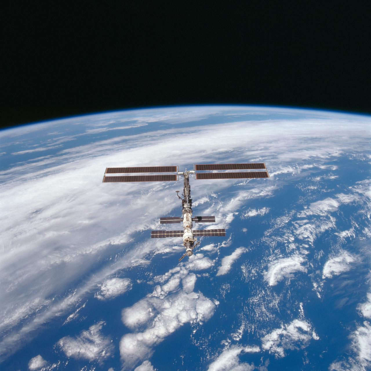
STS097-703-090 (9 December 2000) --- This picture is one of a series of 70mm frames exposed of the International Space Station (ISS) following undocking at 1:13 p.m. (CST), December 9, 2000. This series of images, as well as video and digital still imagery taken at the same time, represent the first imagery of the entire station with its new solar array panels deployed. Before separation, the shuttle and space station had been docked to one another for 6 days, 23 hours and 13 minutes. Endeavour moved downward from the space station, then began a tail-first circle at a distance of about 500 feet. The maneuver, with pilot Michael J. Bloomfield at the controls, took about an hour. While Endeavour flew that circle, the two spacecraft, moving at five miles a second, navigated about two-thirds of the way around the Earth. Undocking took place 235 statute miles above the border of Kazakhstan and China. When Endeavour made its final separation burn, the orbiter and the space station were near the northeastern coast of South America.
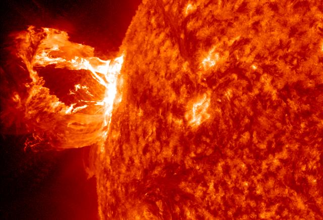
A beautiful prominence eruption shot off the east limb (left side) of the sun on Monday, April 16, 2012. Such eruptions are often associated with solar flares, and in this case an M1 class (medium-sized) flare did occur at the same time, though it was not aimed toward Earth. This event, which is still in progress, was seen by NASA’s SDO satellite. <b>View a video of this event here: <a href="http://www.flickr.com/photos/gsfc/7084820027">www.flickr.com/photos/gsfc/7084820027</a></b> Credit: NASA/GSFC/SDO <b><a href="http://www.nasa.gov/audience/formedia/features/MP_Photo_Guidelines.html" rel="nofollow">NASA image use policy.</a></b> <b><a href="http://www.nasa.gov/centers/goddard/home/index.html" rel="nofollow">NASA Goddard Space Flight Center</a></b> enables NASA’s mission through four scientific endeavors: Earth Science, Heliophysics, Solar System Exploration, and Astrophysics. Goddard plays a leading role in NASA’s accomplishments by contributing compelling scientific knowledge to advance the Agency’s mission. <b>Follow us on <a href="http://twitter.com/NASA_GoddardPix" rel="nofollow">Twitter</a></b> <b>Like us on <a href="http://www.facebook.com/pages/Greenbelt-MD/NASA-Goddard/395013845897?ref=tsd" rel="nofollow">Facebook</a></b> <b>Find us on <a href="http://instagrid.me/nasagoddard/?vm=grid" rel="nofollow">Instagram</a></b>

STS097-712-001 (9 December 2000) --- This picture of the distant International Space Station (ISS) blended against the darkness of space and the blue Earth at its horizon is one of a series of 70mm frames exposed of the station following undocking at 1:13 p.m. (CST), December 9, 2000. This series of images, as well as video and digital still imagery taken at the same time, represent the first imagery of the entire station with its new solar array panels deployed. Before separation, the shuttle and space station had been docked to one another for 6 days, 23 hours and 13 minutes. Endeavour moved downward from the space station, then began a tail-first circle at a distance of about 500 feet. The maneuver, with pilot Michael J. Bloomfield at the controls, took about an hour. While Endeavour flew that circle, the two spacecraft, moving at five miles a second, navigated about two-thirds of the way around the Earth. Undocking took place 235 statute miles above the border of Kazakhstan and China. When Endeavour made its final separation burn, the orbiter and the space station were near the northeastern coast of South America.

A development model rover that is part of NASA's CADRE (Cooperative Autonomous Distributed Robotic Exploration) technology demonstration took its first autonomous drive around the Mars Yard at the agency's Jet Propulsion Laboratory in Southern California in June 2023. The CADRE team tested a new wheel design, surface navigation software, and mobility capabilities, among other aspects of the project. Engineer Kristopher Sherrill is shown recording video of the test. The rover being tested is similar in size and appearance to the flight models of the CADRE rovers, which are still being built. Slated to arrive at the Moon in spring 2024 as part of NASA's CLPS (Commercial Lunar Payload Services) initiative, CADRE is designed to demonstrate that multiple robots can cooperate and explore together autonomously – without direct input from human mission controllers. A trio of the miniature solar-powered rovers, each about the size of a carry-on suitcase, will explore the Moon as a team, communicating via radio with each other and a base station aboard a lunar lander. By taking simultaneous measurements from multiple locations, CADRE will also demonstrate how multirobot missions can record data impossible for a single robot to achieve – a tantalizing prospect for future missions. Movie available at https://photojournal.jpl.nasa.gov/catalog/PIA25665
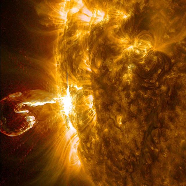
An active region at the edge of the Sun blew out an X4 flare (one of the largest of the solar cycle) and a coronal mass ejection on Feb. 25, 2014. The still image of the ejected plasma (taken at 00:45 UT) shows it curled like a shrimp, but this eruption was no shrimp: it was powerful. The images seen here are a combination of two wavelengths of extreme ultraviolet light (171 and 304 Angstroms). The video clip covers about three hours of activity. Credit: NASA/GSFC/Solar Dynamics Observatory <b><a href="http://www.nasa.gov/audience/formedia/features/MP_Photo_Guidelines.html" rel="nofollow">NASA image use policy.</a></b> <b><a href="http://www.nasa.gov/centers/goddard/home/index.html" rel="nofollow">NASA Goddard Space Flight Center</a></b> enables NASA’s mission through four scientific endeavors: Earth Science, Heliophysics, Solar System Exploration, and Astrophysics. Goddard plays a leading role in NASA’s accomplishments by contributing compelling scientific knowledge to advance the Agency’s mission. <b>Follow us on <a href="http://twitter.com/NASAGoddardPix" rel="nofollow">Twitter</a></b> <b>Like us on <a href="http://www.facebook.com/pages/Greenbelt-MD/NASA-Goddard/395013845897?ref=tsd" rel="nofollow">Facebook</a></b> <b>Find us on <a href="http://instagram.com/nasagoddard?vm=grid" rel="nofollow">Instagram</a></b>
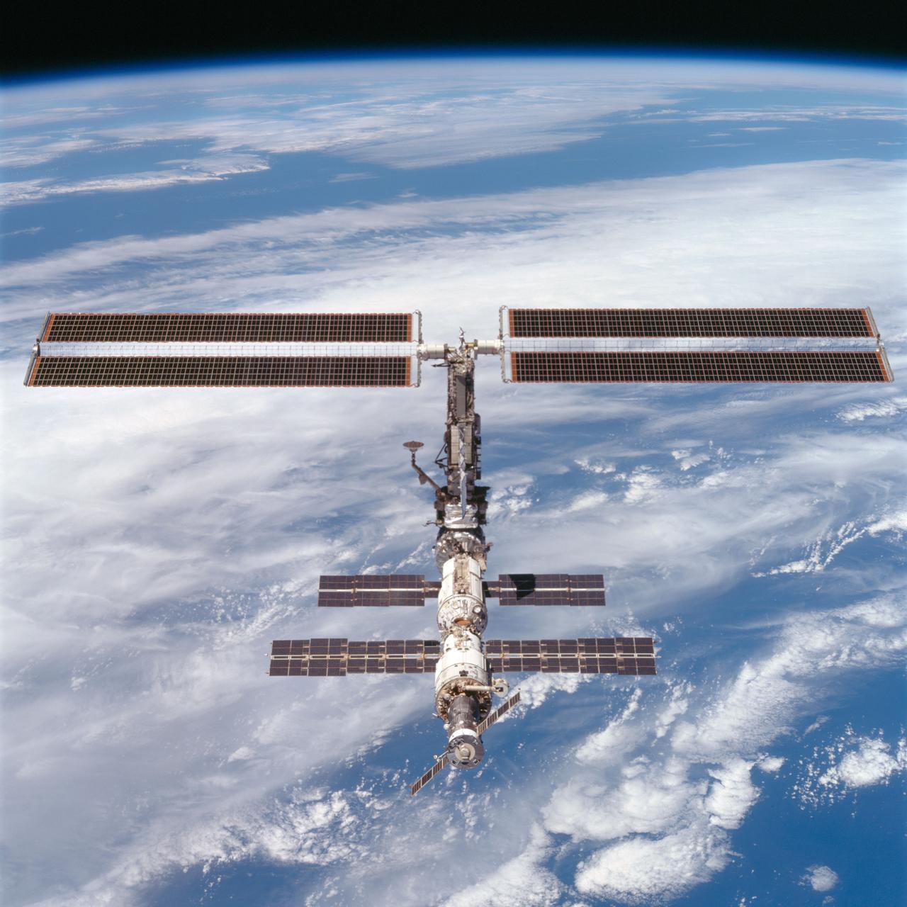
STS097-704-074 (9 December 2000) --- This picture is one of a series of 70mm frames exposed of the International Space Station (ISS) following undocking at 1:13 p.m. (CST), December 9, 2000. This series of images, as well as video and digital still imagery taken at the same time, represent the first imagery of the entire station with its new solar array panels deployed. Before separation, the shuttle and space station had been docked to one another for 6 days, 23 hours and 13 minutes. Endeavour moved downward from the space station, then began a tail-first circle at a distance of about 500 feet. The maneuver, with pilot Michael J. Bloomfield at the controls, took about an hour. While Endeavour flew that circle, the two spacecraft, moving at five miles a second, navigated about two-thirds of the way around the Earth. Undocking took place 235 statute miles above the border of Kazakhstan and China. When Endeavour made its final separation burn, the orbiter and the space station were near the northeastern coast of South America.
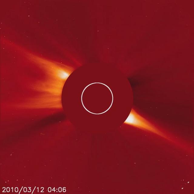
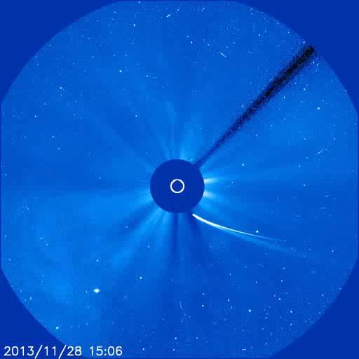
Captured March 12, 2010 The SOHO spacecraft captured a very bright, sungrazing comet as it rocketed towards the Sun (Mar. 12, 2010) and was vaporized. This comet is arguably the brightest comet that SOHO has observed since Comet McNaught in early 2007. The comet is believed to belong to the Kreutz family of comets that broke up from a much larger comet many hundreds of years ago. They are known to orbit close to the Sun. A coronal mass ejection (CME) burst away from the Sun during the bright comet’s approach. Interestingly, a much smaller comet that preceded this one can be seen about half a day earlier on just about the identical route. And another pair of small comets followed the same track into the Sun after the bright one. Such a string of comets has never been witnessed before by SOHO. SOHO's C3 coronagraph instrument blocks out the Sun with an occulting disk; the white circle represents the size of the Sun. The planet Mercury can also be seen moving from left to right just beneath the Sun. To learn more and to download the video and still images go here: <a href="http://sohowww.nascom.nasa.gov/pickoftheweek/old/15mar2010/" rel="nofollow">sohowww.nascom.nasa.gov/pickoftheweek/old/15mar2010/</a> Credit: NASA/GSFC/SOHO
STS097-704-080 (9 December 2000) --- This picture is one of a series of 70mm frames exposed of the International Space Station (ISS) following undocking at 1:13 p.m. (CST), December 9, 2000. This series of images, as well as video and digital still imagery taken at the same time, represent the first imagery of the entire station with its new solar array panels deployed. Before separation, the shuttle and space station had been docked to one another for 6 days, 23 hours and 13 minutes. Endeavour moved downward from the space station, then began a tail-first circle at a distance of about 500 feet. The maneuver, with pilot Michael J. Bloomfield at the controls, took about an hour. While Endeavour flew that circle, the two spacecraft, moving at five miles a second, navigated about two-thirds of the way around the Earth. Undocking took place 235 statute miles above the border of Kazakhstan and China. When Endeavour made its final separation burn, the orbiter and the space station were near the northeastern coast of South America.
STS097-703-093 (9 December 2000) --- This picture is one of a series of 70mm frames exposed of the International Space Station (ISS) following undocking at 1:13 p.m. (CST), December 9, 2000. This series of images, as well as video and digital still imagery taken at the same time, represent the first imagery of the entire station with its new solar array panels deployed. Before separation, the shuttle and space station had been docked to one another for 6 days, 23 hours and 13 minutes. Endeavour moved downward from the space station, then began a tail-first circle at a distance of about 500 feet. The maneuver, with pilot Michael J. Bloomfield at the controls, took about an hour. While Endeavour flew that circle, the two spacecraft, moving at five miles a second, navigated about two-thirds of the way around the Earth. Undocking took place 235 statute miles above the border of Kazakhstan and China. When Endeavour made its final separation burn, the orbiter and the space station were near the northeastern coast of South America.

This frame from a video depicts artist concepts of each of the seven planets orbiting TRAPPIST-1, an ultra-cool dwarf stars. Over 21 days, NASA's Spitzer Space Telescope measured the drop in light as each planet passed in front of the star. Spitzer was able to identify a total of seven rocky worlds, including three in the habitable zone where life is possible. The study established the planets' size, distance from their sun and, for some of them, their approximate mass and density. It also established that some, if not all, these planets are tidally locked, meaning one face of the planet permanently faces their sun. The planets appear in the order of innermost to outermost planets. These artist's concepts were designed as follows: TRAPPIST-1b, closest to the star, was modeled on Jupiter's moon Io, which has volcanic features due to strong gravitational tugs. TRAPPIST-1c is shown as a rocky, warm world with a small ice cap on the side that never faces the star. TRAPPSIT-1d is rocky and has water only in a thin band along the terminator, dividing the day side and night side. TRAPPIST-1e and TRAPPIST-1f are both shown covered in water, but with progressively larger ice caps on the night side. TRAPPIST-1g is portrayed with an atmosphere like Neptune's, although it is still a rocky world. The farthest planet, TRAPPIST-1h, is shown as covered in ice, similar to Jupiter's icy moon Europa. The background stars are what you would see if you were in the TRAPPIST-1 system. Orion passes behind the planets, recognizable but distorted from what we're familiar with, in addition to Taurus and Pleiades. A video is available at http://photojournal.jpl.nasa.gov/catalog/PIA21468
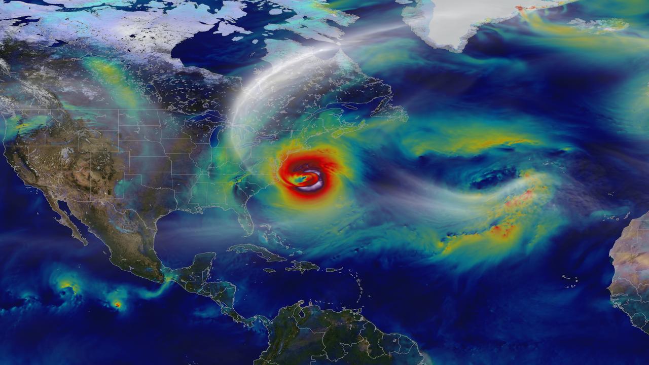
Oct. 29, 2012 – A day before landfall, Sandy intensified into a Category 2 superstorm nearly 1,000 miles wide. Credit: NASA's Goddard Space Flight Center and NASA Center for Climate Simulation Video and images courtesy of NASA/GSFC/William Putman -- A NASA computer model simulates the astonishing track and forceful winds of Hurricane Sandy. Hurricane Sandy pummeled the East Coast late in 2012’s Atlantic hurricane season, causing 159 deaths and $70 billion in damages. Days before landfall, forecasts of its trajectory were still being made. Some computer models showed that a trough in the jet stream would kick the monster storm away from land and out to sea. Among the earliest to predict its true course was NASA’s GEOS-5 global atmosphere model. The model works by dividing Earth’s atmosphere into a virtual grid of stacked boxes. A supercomputer then solves mathematical equations inside each box to create a weather forecast predicting Sandy’s structure, path and other traits. The NASA model not only produced an accurate track of Sandy, but also captured fine-scale details of the storm’s changing intensity and winds. Watch the video to see it for yourself. For more information, please visit: <a href="http://gmao.gsfc.nasa.gov/research/atmosphericassim/tracking_hurricanes/" rel="nofollow">gmao.gsfc.nasa.gov/research/atmosphericassim/tracking_hur...</a> <b><a href="http://www.nasa.gov/audience/formedia/features/MP_Photo_Guidelines.html" rel="nofollow">NASA image use policy.</a></b> <b><a href="http://www.nasa.gov/centers/goddard/home/index.html" rel="nofollow">NASA Goddard Space Flight Center</a></b> enables NASA’s mission through four scientific endeavors: Earth Science, Heliophysics, Solar System Exploration, and Astrophysics. Goddard plays a leading role in NASA’s accomplishments by contributing compelling scientific knowledge to advance the Agency’s mission. <b>Follow us on <a href="http://twitter.com/NASA_GoddardPix" rel="nofollow">Twitter</a></b> <b>Like us on <a href="http://www.facebook.com/pages/Greenbelt-MD/NASA-Goddard/395013845897?ref=tsd" rel="nofollow">Facebook</a></b> <b>Find us on <a href="http://instagram.com/nasagoddard?vm=grid" rel="nofollow">Instagram</a></b>

<b>To view a video of the Gradient Sun go to: <a href="http://www.flickr.com/photos/gsfc/8103212817">www.flickr.com/photos/gsfc/8103212817</a></b> Looking at a particularly beautiful image of the sun helps show how the lines between science and art can sometimes blur. But there is more to the connection between the two disciplines: science and art techniques are often quite similar, indeed one may inform the other or be improved based on lessons from the other arena. One such case is a technique known as a "gradient filter" – recognizable to many people as an option available on a photo-editing program. Gradients are, in fact, a mathematical description that highlights the places of greatest physical change in space. A gradient filter, in turn, enhances places of contrast, making them all the more obviously different, a useful tool when adjusting photos. Scientists, too, use gradient filters to enhance contrast, using them to accentuate fine structures that might otherwise be lost in the background noise. On the sun, for example, scientists wish to study a phenomenon known as coronal loops, which are giant arcs of solar material constrained to travel along that particular path by the magnetic fields in the sun's atmosphere. Observations of the loops, which can be more or less tangled and complex during different phases of the sun's 11-year activity cycle, can help researchers understand what's happening with the sun's complex magnetic fields, fields that can also power great eruptions on the sun such as solar flares or coronal mass ejections. The still here shows an unfiltered image from the sun next to one that has been processed using a gradient filter. Note how the coronal loops are sharp and defined, making them all the more easy to study. On the other hand, gradients also make great art. NASA/Goddard Space Flight Center To download this video go to: <a href="http://svs.gsfc.nasa.gov/goto?11112" rel="nofollow">svs.gsfc.nasa.gov/goto?11112</a> <b><a href="http://www.nasa.gov/audience/formedia/features/MP_Photo_Guidelines.html" rel="nofollow">NASA image use policy.</a></b> <b><a href="http://www.nasa.gov/centers/goddard/home/index.html" rel="nofollow">NASA Goddard Space Flight Center</a></b> enables NASA’s mission through four scientific endeavors: Earth Science, Heliophysics, Solar System Exploration, and Astrophysics. Goddard plays a leading role in NASA’s accomplishments by contributing compelling scientific knowledge to advance the Agency’s mission. <b>Follow us on <a href="http://twitter.com/NASA_GoddardPix" rel="nofollow">Twitter</a></b> <b>Like us on <a href="http://www.facebook.com/pages/Greenbelt-MD/NASA-Goddard/395013845897?ref=tsd" rel="nofollow">Facebook</a></b> <b>Find us on <a href="http://instagrid.me/nasagoddard/?vm=grid" rel="nofollow">Instagram</a></b>
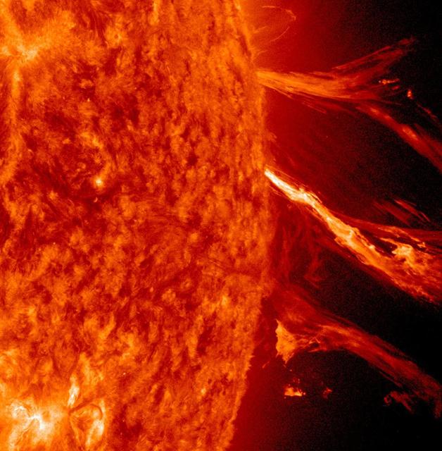
The Sun sported a very long filament that stretched out over 500,000 miles (800,000 km) and was visible for several days (June 3-4, 2014). It broke apart and dissipated soon after the end of the video clip. Filaments are tenuous strands of plasma held above the Sun's surface by magnetic forces. They appear darker because their temperature is somewhat cooler than that of the Sun's surface. The still image, shown in a combination of two wavelengths of extreme ultraviolet light, was taken at 11:33 UT on June 4. Credit: NASA/Goddard/Solar Dynamics Observatory <b><a href="http://www.nasa.gov/audience/formedia/features/MP_Photo_Guidelines.html" rel="nofollow">NASA image use policy.</a></b> <b><a href="http://www.nasa.gov/centers/goddard/home/index.html" rel="nofollow">NASA Goddard Space Flight Center</a></b> enables NASA’s mission through four scientific endeavors: Earth Science, Heliophysics, Solar System Exploration, and Astrophysics. Goddard plays a leading role in NASA’s accomplishments by contributing compelling scientific knowledge to advance the Agency’s mission. <b>Follow us on <a href="http://twitter.com/NASAGoddardPix" rel="nofollow">Twitter</a></b> <b>Like us on <a href="http://www.facebook.com/pages/Greenbelt-MD/NASA-Goddard/395013845897?ref=tsd" rel="nofollow">Facebook</a></b> <b>Find us on <a href="http://instagram.com/nasagoddard?vm=grid" rel="nofollow">Instagram</a></b>
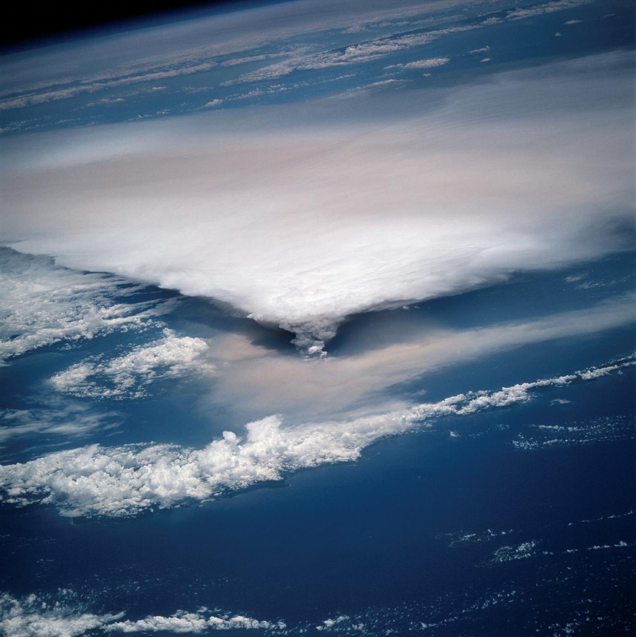
STS064-116-064 (20 Sept. 1994) --- Near the end of the mission, the crew aboard space shuttle Discovery was able to document the beginning of the second day of activity of the Rabaul volcano, on the east end of New Britain. On the morning of Sept. 19, 1994, two volcanic cones on the opposite sides of the 6-kilometer sea crater had begun to erupt with very little warning. Discovery flew just east of the eruption roughly 24 hours after it started and near the peak of its activity. New Ireland, the cloud-covered area in the foreground, lies just east of Rabaul harbor. The eruption, which sent a plume up to over 60,000 feet into the atmosphere, caused over 50,000 people to evacuate the area. Because winds were light at the time of the eruption, most of the ash was deposited in a region within 20 kilometers of the eruption zone. This photo shows the large white billowing eruption plume is carried in a westerly direction by the weak prevailing winds. At the base of the eruption column is a layer of yellow-brown ash being distributed by lower level winds. A sharp boundary moving outward from the center of the eruption in the lower cloud is a pulse of laterally-moving ash which results from a volcanic explosion. Geologists theorize that the large white column and the lower gray cloud are likely from the two main vents on each side of the harbor. The bay and harbor of Rabaul are covered with a layer of ash, possibly partly infilled with volcanic material. Matupit Island and the airport runway have disappeared into the bay. More than a meter of ash has fallen upon the city of Rabaul. Up to five vents were reported to have erupted at once, including the two cones Vulcan and Tavurvur, which are opposites of the harbor as well as new vents below the bay. Half of the Vulcan cone has collapsed into the sea. The extra day in space due to bad weather at the landing site afforded the crew the opportunity for both still and video coverage of the event. Photo credit: NASA or National Aeronautics and Space Administration
This movie shows Comet ISON orbiting around the sun – represented by the white circle -- on Nov. 28, 2013. ISON looks smaller as it streams away, but scientists believe its nucleus may still be intact. The video covers Nov. 27, 2013, 3:30 p.m. EST to Nov. 29, 2013, 8:30 a.m. EST. Continuing a history of surprising behavior, material from Comet ISON appeared on the other side of the sun on the evening on Nov. 28, 2013, despite not having been seen in observations during its closest approach to the sun. The question remains whether it is merely debris from the comet, or if some portion of the comet's nucleus survived, but late-night analysis from scientists with NASA's Comet ISON Observing Campaign suggest that there is at least a small nucleus intact. Credit: ESA/NASA/SOHO/Jhelioviewer <b><a href="http://www.nasa.gov/audience/formedia/features/MP_Photo_Guidelines.html" rel="nofollow">NASA image use policy.</a></b> <b><a href="http://www.nasa.gov/centers/goddard/home/index.html" rel="nofollow">NASA Goddard Space Flight Center</a></b> enables NASA’s mission through four scientific endeavors: Earth Science, Heliophysics, Solar System Exploration, and Astrophysics. Goddard plays a leading role in NASA’s accomplishments by contributing compelling scientific knowledge to advance the Agency’s mission. <b>Follow us on <a href="http://twitter.com/NASA_GoddardPix" rel="nofollow">Twitter</a></b> <b>Like us on <a href="http://www.facebook.com/pages/Greenbelt-MD/NASA-Goddard/395013845897?ref=tsd" rel="nofollow">Facebook</a></b> <b>Find us on <a href="http://instagram.com/nasagoddard?vm=grid" rel="nofollow">Instagram</a></b>
NASA image captured January 2, 2012 To view a video of this event go here: <a href="http://www.flickr.com/photos/gsfc/6648724193">www.flickr.com/photos/gsfc/6648724193</a> The Sun erupted with a good-sized solar flare and a coronal mass ejection (CME) on its far-side beyond the view of SDO, but the resulting strands of particle clouds as seen in extreme ultraviolet light still made for quite a show that lasted about three hours (Jan. 2, 2011). Note how a portion of the strands fall back to the Sun. It appears the force of the blast was unable, for some portion of the material, to overcome the pull of the Sun's magnetic fields. This blast was not directed at Earth. Credit: NASA/GSFC/SDO <b><a href="http://www.nasa.gov/audience/formedia/features/MP_Photo_Guidelines.html" rel="nofollow">NASA image use policy.</a></b> <b><a href="http://www.nasa.gov/centers/goddard/home/index.html" rel="nofollow">NASA Goddard Space Flight Center</a></b> enables NASA’s mission through four scientific endeavors: Earth Science, Heliophysics, Solar System Exploration, and Astrophysics. Goddard plays a leading role in NASA’s accomplishments by contributing compelling scientific knowledge to advance the Agency’s mission. <b>Follow us on <a href="http://twitter.com/NASA_GoddardPix" rel="nofollow">Twitter</a></b> <b>Like us on <a href="http://www.facebook.com/pages/Greenbelt-MD/NASA-Goddard/395013845897?ref=tsd" rel="nofollow">Facebook</a></b> <b>Find us on <a href="http://instagrid.me/nasagoddard/?vm=grid" rel="nofollow">Instagram</a></b>
![Final still from Fermi video [<a href="http://bit.ly/Y2K4LN" rel="nofollow">bit.ly/Y2K4LN</a>]. Credit: NASA/DOE/Fermi LAT Collaboration ----- NASA's Fermi Gamma-ray Space Telescope orbits our planet every 95 minutes, building up increasingly deeper views of the universe with every circuit. Its wide-eyed Large Area Telescope (LAT) sweeps across the entire sky every three hours, capturing the highest-energy form of light -- gamma rays -- from sources across the universe. These range from supermassive black holes billions of light-years away to intriguing objects in our own galaxy, such as X-ray binaries, supernova remnants and pulsars. Now a Fermi scientist has transformed LAT data of a famous pulsar into a mesmerizing movie that visually encapsulates the spacecraft's complex motion. Click here to continue reading: <a href="http://1.usa.gov/WhYwCU" rel="nofollow">1.usa.gov/WhYwCU</a> <b><a href="http://www.nasa.gov/audience/formedia/features/MP_Photo_Guidelines.html" rel="nofollow">NASA image use policy.</a></b> <b><a href="http://www.nasa.gov/centers/goddard/home/index.html" rel="nofollow">NASA Goddard Space Flight Center</a></b> enables NASA’s mission through four scientific endeavors: Earth Science, Heliophysics, Solar System Exploration, and Astrophysics. Goddard plays a leading role in NASA’s accomplishments by contributing compelling scientific knowledge to advance the Agency’s mission. <b>Follow us on <a href="http://twitter.com/NASA_GoddardPix" rel="nofollow">Twitter</a></b> <b>Like us on <a href="http://www.facebook.com/pages/Greenbelt-MD/NASA-Goddard/395013845897?ref=tsd" rel="nofollow">Facebook</a></b> <b>Find us on <a href="http://instagram.com/nasagoddard?vm=grid" rel="nofollow">Instagram</a></b>](https://images-assets.nasa.gov/image/GSFC_20171208_Archive_e001547/GSFC_20171208_Archive_e001547~small.jpg)
Final still from Fermi video [<a href="http://bit.ly/Y2K4LN" rel="nofollow">bit.ly/Y2K4LN</a>]. Credit: NASA/DOE/Fermi LAT Collaboration ----- NASA's Fermi Gamma-ray Space Telescope orbits our planet every 95 minutes, building up increasingly deeper views of the universe with every circuit. Its wide-eyed Large Area Telescope (LAT) sweeps across the entire sky every three hours, capturing the highest-energy form of light -- gamma rays -- from sources across the universe. These range from supermassive black holes billions of light-years away to intriguing objects in our own galaxy, such as X-ray binaries, supernova remnants and pulsars. Now a Fermi scientist has transformed LAT data of a famous pulsar into a mesmerizing movie that visually encapsulates the spacecraft's complex motion. Click here to continue reading: <a href="http://1.usa.gov/WhYwCU" rel="nofollow">1.usa.gov/WhYwCU</a> <b><a href="http://www.nasa.gov/audience/formedia/features/MP_Photo_Guidelines.html" rel="nofollow">NASA image use policy.</a></b> <b><a href="http://www.nasa.gov/centers/goddard/home/index.html" rel="nofollow">NASA Goddard Space Flight Center</a></b> enables NASA’s mission through four scientific endeavors: Earth Science, Heliophysics, Solar System Exploration, and Astrophysics. Goddard plays a leading role in NASA’s accomplishments by contributing compelling scientific knowledge to advance the Agency’s mission. <b>Follow us on <a href="http://twitter.com/NASA_GoddardPix" rel="nofollow">Twitter</a></b> <b>Like us on <a href="http://www.facebook.com/pages/Greenbelt-MD/NASA-Goddard/395013845897?ref=tsd" rel="nofollow">Facebook</a></b> <b>Find us on <a href="http://instagram.com/nasagoddard?vm=grid" rel="nofollow">Instagram</a></b>
Though NASA MESSENGER days are numbered, the spacecraft will continue to acquire new data sets and transmit them back to Earth during its final days. Shown here is a high-resolution view snapped near Heemskerck Rupes, named for the Dutch ship that explored Australia and New Zealand in 1642-1643. The total number of images that MDIS has acquired and returned to Earth since entering Mercury orbit in March 2011 is currently 277,447, which is many more than originally planned for MESSENGER's one-year primary mission! In the next few days, approximately 500 additional images are planned to be received back at Earth, though the spacecraft is expected to impact the planet on April 30 with more than a thousand images still on its recorder, never to be seen. This is by design, as it is better to collect more data than can be transmitted than end the mission having been able to possibly have done more! Check out some highlights from the MESSENGER mission by visiting this image collection, or watch MESSENGER team members discuss the mission in these recently posted videos. Date acquired: April 26, 2015 Image Mission Elapsed Time (MET): 72384761 Image ID: 8400449 Instrument: Narrow Angle Camera (NAC) of the Mercury Dual Imaging System (MDIS) Center Latitude: 25.1° Center Longitude: 234.4° E Resolution: 6.7 meters/pixel Scale: The bottom of this image is about 7 kilometers (4.3 miles) across Incidence Angle: 57.9° Emission Angle: 56.5° Phase Angle: 40.7° http://photojournal.jpl.nasa.gov/catalog/PIA19438
Caption: This is a conceptual animation showing ozone-depleting chemicals moving from the equator to the poles. The chemicals become trapped by the winds of the polar vortex, a ring of fast moving air that circles the South Pole. Watch full video: <a href="https://youtu.be/7n2km69jZu8" rel="nofollow">youtu.be/7n2km69jZu8</a> -- The next three decades will see an end of the era of big ozone holes. In a new study, scientists from NASA Goddard Space Flight Center say that the ozone hole will be consistently smaller than 12 million square miles by the year 2040. Ozone-depleting chemicals in the atmosphere cause an ozone hole to form over Antarctica during the winter months in the Southern Hemisphere. Since the Montreal Protocol agreement in 1987, emissions have been regulated and chemical levels have been declining. However, the ozone hole has still remained bigger than 12 million square miles since the early 1990s, with exact sizes varying from year to year. The size of the ozone hole varies due to both temperature and levels of ozone-depleting chemicals in the atmosphere. In order to get a more accurate picture of the future size of the ozone hole, scientists used NASA’s AURA satellite to determine how much the levels of these chemicals in the atmosphere varied each year. With this new knowledge, scientists can confidently say that the ozone hole will be consistently smaller than 12 million square miles by the year 2040. Scientists will continue to use satellites to monitor the recovery of the ozone hole and they hope to see its full recovery by the end of the century. Research: Inorganic chlorine variability in the Antarctic vortex and implications for ozone recovery. Journal: Geophysical Research: Atmospheres, December 18, 2014. Link to paper: <a href="http://onlinelibrary.wiley.com/doi/10.1002/2014JD022295/abstract" rel="nofollow">onlinelibrary.wiley.com/doi/10.1002/2014JD022295/abstract</a>.
NASA image captured Feb. 24, 2011 To see an image showing the size of the prominence in comparison to the <b><a href="http://www.flickr.com/photos/gsfc/5492781335/">size of earth click here.</a></b> To view a video of this event go to: <a href="http://www.flickr.com/photos/gsfc/5483193591">www.flickr.com/photos/gsfc/5483193591</a> When a rather large-sized (M 3.6 class) flare occurred near the edge of the Sun, it blew out a gorgeous, waving mass of erupting plasma that swirled and twisted over a 90-minute period (Feb. 24, 2011). This event was captured in extreme ultraviolet light by NASA's Solar Dynamics Observatory spacecraft . Some of the material blew out into space and other portions fell back to the surface. Because SDO images are super-HD, we can zoom in on the action and still see exquisite details. And using a cadence of a frame taken every 24 seconds, the sense of motion is, by all appearances, seamless. Sit back and enjoy the jaw-dropping solar show. Credit: NASA/GSFC/SDO <b><a href="http://www.nasa.gov/centers/goddard/home/index.html" rel="nofollow">NASA Goddard Space Flight Center</a></b> enables NASA’s mission through four scientific endeavors: Earth Science, Heliophysics, Solar System Exploration, and Astrophysics. Goddard plays a leading role in NASA’s accomplishments by contributing compelling scientific knowledge to advance the Agency’s mission. <b>Follow us on <a href="http://twitter.com/NASA_GoddardPix" rel="nofollow">Twitter</a></b> <b>Join us on <a href="http://www.facebook.com/pages/Greenbelt-MD/NASA-Goddard/395013845897?ref=tsd" rel="nofollow">Facebook</a></b>
Completed: 07-16-2009 Straddling the equator approximately 1000 kilometers to the west of the South American mainland, the Galapagos Islands lie within the heart of the equatorial current system. Rising from the sea floor, the volcanic islands of the Galapagos are set on top of a large submarine platform. The main portion of the Galapagos platform is relatively flat and less than 1000 meters in depth. The steepest slopes are found along the western and southern flanks of the platform with a gradual slope towards the east. The interactions of the Galapagos and the oceanic currents create vastly different environmental regimes which not only isolates one part of the Archipelago from the other but allows penguins to live along the equator on the western part of the Archipelago and tropical corals around the islands to the north. The islands are relatively new in geologic terms with the youngest islands in the west still exhibiting periodic eruptions from their massive volcanic craters. Please give credit for this item to: NASA/Goddard Space Flight Center, The SeaWiFS Project and GeoEye, Scientific Visualization Studio. NOTE: All SeaWiFS images and data presented on this web site are for research and educational use only. All commercial use of SeaWiFS data must be coordinated with GeoEye (http://www.geoeye.com). To download this video go to: <a href="http://svs.gsfc.nasa.gov/goto?3628" rel="nofollow">svs.gsfc.nasa.gov/goto?3628</a> <b><a href="http://www.nasa.gov/centers/goddard/home/index.html" rel="nofollow">NASA Goddard Space Flight Center</a></b> is home to the nation's largest organization of combined scientists, engineers and technologists that build spacecraft, instruments and new technology to study the Earth, the sun, our solar system, and the universe.

As the sun sets over the Arctic, the end of this year’s melt season is quickly approaching and the sea ice cover has already shrunk to the fourth lowest in the satellite record. With possibly some days of melting left, the sea ice extent could still drop to the second or third lowest on record. Arctic sea ice, which regulates the planet’s temperature by bouncing solar energy back to space, has been on a steep decline for the last two decades. This animation shows the evolution of Arctic sea ice in 2015, from its annual maximum wintertime extent, reached on February 25, to September 6. Credit: NASA Scientific Visualization Studio DOWNLOAD THIS VIDEO HERE: <a href="https://svs.gsfc.nasa.gov/cgi-bin/details.cgi?aid=11999" rel="nofollow">svs.gsfc.nasa.gov/cgi-bin/details.cgi?aid=11999</a> <b><a href="http://www.nasa.gov/audience/formedia/features/MP_Photo_Guidelines.html" rel="nofollow">NASA image use policy.</a></b> <b><a href="http://www.nasa.gov/centers/goddard/home/index.html" rel="nofollow">NASA Goddard Space Flight Center</a></b> enables NASA’s mission through four scientific endeavors: Earth Science, Heliophysics, Solar System Exploration, and Astrophysics. Goddard plays a leading role in NASA’s accomplishments by contributing compelling scientific knowledge to advance the Agency’s mission. <b>Follow us on <a href="http://twitter.com/NASAGoddardPix" rel="nofollow">Twitter</a></b> <b>Like us on <a href="http://www.facebook.com/pages/Greenbelt-MD/NASA-Goddard/395013845897?ref=tsd" rel="nofollow">Facebook</a></b> <b>Find us on <a href="http://instagrid.me/nasagoddard/?vm=grid" rel="nofollow">Instagram</a></b>
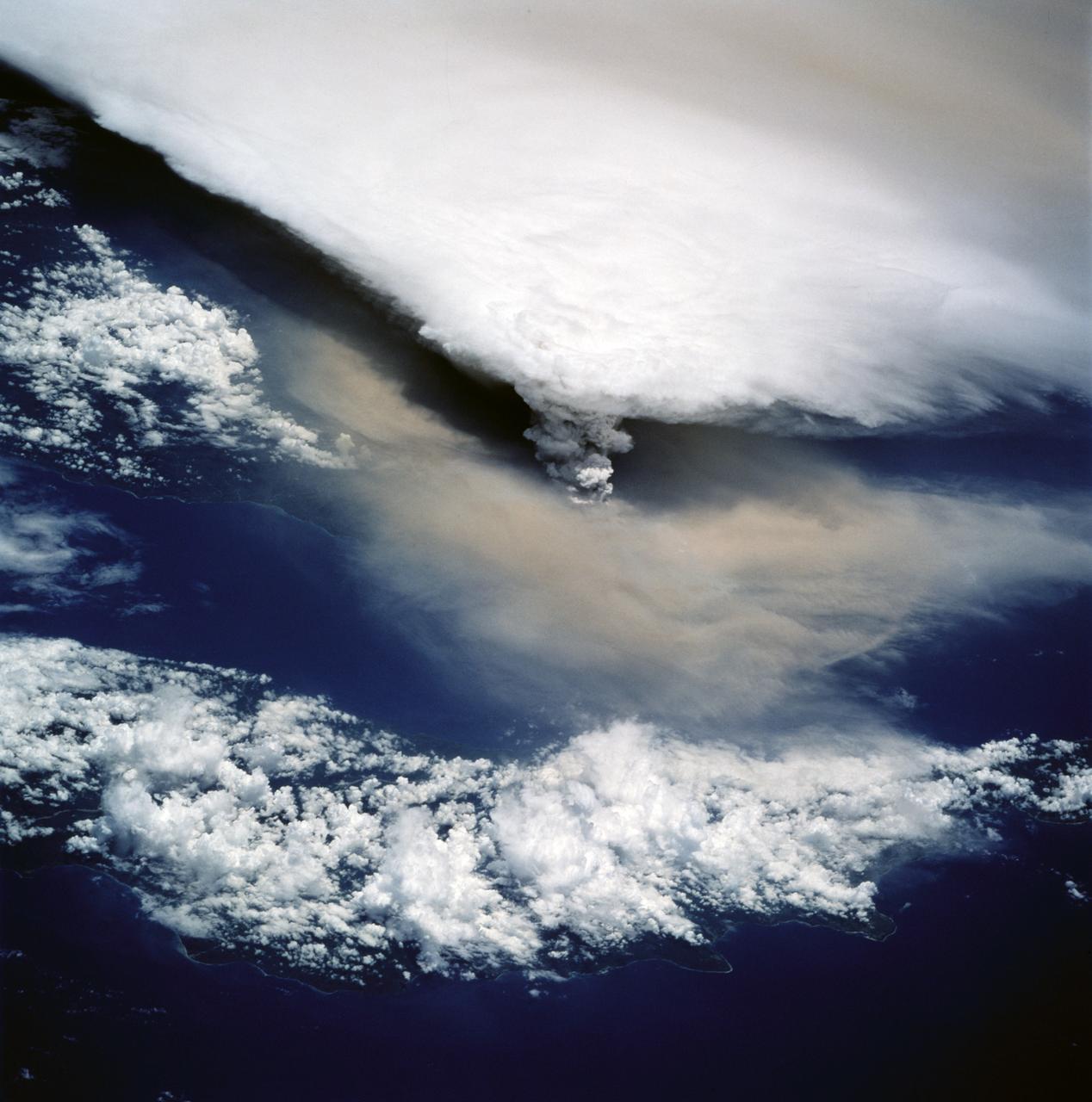
STS064-116-055 (20 Sept. 1994) --- Near the end of its mission, the crew aboard space shuttle Discovery was able to document the beginning of the second day of activity of the Rabaul volcano, on the east end of New Britain. On the morning of Sept. 19, 1994, two volcanic cones on the opposite sides of the 6-kilometer sea crater had begun to erupt with very little warning. Discovery flew just east of the eruption roughly 24 hours after it started and near the peak of its activity. The eruption, which sent a plume up to over 60,000 feet into the atmosphere, caused over 50,000 people to evacuate the area. Because winds were light at the time of the eruption, most of the ash was deposited in a region within 20 kilometers of the eruption zone. This photo shows the large white billowing eruption plume is carried in a westerly direction by the weak prevailing winds. At the base of the eruption column is a layer of yellow-brown ash being distributed by lower level winds. A sharp boundary moving outward from the center of the eruption in the lower cloud is a pulse of laterally-moving ash which results from a volcanic explosion. Geologists theorize that the large white column and the lower gray cloud are likely from the two main vents on each side of the harbor. The cloud-covered island in the foreground is New Ireland. The bay and harbor of Rabaul are covered with a layer of ash, possibly partly infilled with volcanic material. Matupit Island and the airport runway have disappeared into the bay. More than a meter of ash has fallen upon the city of Rabaul. Up to five vents were reported to have erupted at once, including the cones Vulcan and Tavurvur, which are opposites of the harbor as well as new vents below the bay. Half of the Vulcan cone has collapsed into the sea. The extra day in space due to bad weather at the landing site afforded the crew the opportunity for both still and video coverage of the event. Photo credit: NASA or National Aeronautics and Space Administration
This mosaic of images combines views captured by NASA's Cassini spacecraft as it made the first dive of the mission's Grand Finale on April 26, 2017. It shows a vast swath of Saturn's atmosphere, from the north polar vortex to the boundary of the hexagon-shaped jet stream, to details in bands and swirls at middle latitudes and beyond. The mosaic is a composite of 137 images captured as Cassini made its first dive toward the gap between Saturn and its rings. It is an update to a previously released image product. In the earlier version, the images were presented as individual movie frames, whereas here, they have been combined into a single, continuous mosaic. The mosaic is presented as a still image as well as a video that pans across its length. Imaging scientists referred to this long, narrow mosaic as a "noodle" in planning the image sequence. The first frame of the mosaic is centered on Saturn's north pole, and the last frame is centered on a region at 18 degrees north latitude. During the dive, the spacecraft's altitude above the clouds changed from 45,000 to 3,200 miles (72,400 to 8374 kilometers), while the image scale changed from 5.4 miles (8.7 kilometers) per pixel to 0.6 mile (1 kilometer) per pixel. The bottom of the mosaic (near the end of the movie) has a curved shape. This is where the spacecraft rotated to point its high-gain antenna in the direction of motion as a protective measure before crossing Saturn's ring plane. The images in this sequence were captured in visible light using the Cassini spacecraft wide-angle camera. The original versions of these images, as sent by the spacecraft, have a size of 512 by 512 pixels. The small image size was chosen in order to allow the camera to take images quickly as Cassini sped over Saturn. These images of the planet's curved surface were projected onto a flat plane before being combined into a mosaic. Each image was mapped in stereographic projection centered at 55 degree north latitude. A movie is available at https://photojournal.jpl.nasa.gov/catalog/PIA21617
The sharp eye of NASA's Hubble Space Telescope has captured the tiny moon Phobos during its orbital trek around Mars. Because the moon is so small, it appears star-like in the Hubble pictures. Over the course of 22 minutes, Hubble took 13 separate exposures, allowing astronomers to create a time-lapse video showing the diminutive moon's orbital path. The Hubble observations were intended to photograph Mars, and the moon's cameo appearance was a bonus. A football-shaped object just 16.5 miles by 13.5 miles by 11 miles, Phobos is one of the smallest moons in the solar system. It is so tiny that it would fit comfortably inside the Washington, D.C. Beltway. The little moon completes an orbit in just 7 hours and 39 minutes, which is faster than Mars rotates. Rising in the Martian west, it runs three laps around the Red Planet in the course of one Martian day, which is about 24 hours and 40 minutes. It is the only natural satellite in the solar system that circles its planet in a time shorter than the parent planet's day. About two weeks after the Apollo 11 manned lunar landing on July 20, 1969, NASA's Mariner 7 flew by the Red Planet and took the first crude close-up snapshot of Phobos. On July 20, 1976 NASA's Viking 1 lander touched down on the Martian surface. A year later, its parent craft, the Viking 1 orbiter, took the first detailed photograph of Phobos, revealing a gaping crater from an impact that nearly shattered the moon. Phobos was discovered by Asaph Hall on August 17, 1877 at the U.S. Naval Observatory in Washington, D.C., six days after he found the smaller, outer moon, named Deimos. Hall was deliberately searching for Martian moons. Both moons are named after the sons of Ares, the Greek god of war, who was known as Mars in Roman mythology. Phobos (panic or fear) and Deimos (terror or dread) accompanied their father into battle. Close-up photos from Mars-orbiting spacecraft reveal that Phobos is apparently being torn apart by the gravitational pull of Mars. The moon is marred by long, shallow grooves that are probably caused by tidal interactions with its parent planet. Phobos draws nearer to Mars by about 6.5 feet every hundred years. Scientists predict that within 30 to 50 million years, it either will crash into the Red Planet or be torn to pieces and scattered as a ring around Mars. Orbiting 3,700 miles above the Martian surface, Phobos is closer to its parent planet than any other moon in the solar system. Despite its proximity, observers on Mars would see Phobos at just one-third the width of the full moon as seen from Earth. Conversely, someone standing on Phobos would see Mars dominating the horizon, enveloping a quarter of the sky. From the surface of Mars, Phobos can be seen eclipsing the sun. However, it is so tiny that it doesn't completely cover our host star. Transits of Phobos across the sun have been photographed by several Mars-faring spacecraft. The origin of Phobos and Deimos is still being debated. Scientists concluded that the two moons were made of the same material as asteroids. This composition and their irregular shapes led some astrophysicists to theorize that the Martian moons came from the asteroid belt. However, because of their stable, nearly circular orbits, other scientists doubt that the moons were born as asteroids. Such orbits are rare for captured objects, which tend to move erratically. An atmosphere could have slowed down Phobos and Deimos and settled them into their current orbits, but the Martian atmosphere is too thin to have circularized the orbits. Also, the moons are not as dense as members of the asteroid belt. Phobos may be a pile of rubble that is held together by a thin crust. It may have formed as dust and rocks encircling Mars were drawn together by gravity. Or, it may have experienced a more violent birth, where a large body smashing into Mars flung pieces skyward, and those pieces were brought together by gravity. Perhaps an existing moon was destroyed, reduced to the rubble that would become Phobos. Hubble took the images of Phobos orbiting the Red Planet on May 12, 2016, when Mars was 50 million miles from Earth. This was just a few days before the planet passed closer to Earth in its orbit than it had in the past 11 years. A time-lapse video captures a portion of the path that tiny Phobos takes around Mars. Over the course of 22 minutes, Hubble snapped 13 separate exposures of the little Martian moon. The video can be viewed at https://photojournal.jpl.nasa.gov/catalog/PIA21837
The sounds and colorful spectrogram in this still image and video represent data collected by the Radio and Plasma Wave Science, or RPWS, instrument on NASA's Cassini spacecraft, as it crossed through Saturn's D ring on May 28, 2017. This was the first of four passes through the inner edge of the D ring during the 22 orbits of Cassini's final mission phase, called the Grand Finale. During this ring plane crossing, the spacecraft was oriented so that its large high-gain antenna was used as a shield to protect more sensitive components from possible ring-particle impacts. The three 33-foot-long (10-meter-long) RPWS antennas were exposed to the particle environment during the pass. As tiny, dust-sized particles strike Cassini and the RPWS antennas, the particles are vaporized into tiny clouds of plasma, or electrically excited gas. These tiny explosions make a small electrical signal (a voltage impulse) that RPWS can detect. Researchers on the RPWS team convert the data into visible and audio formats, some like those seen here, for analysis. Ring particle hits sound like pops and cracks in the audio. Particle impacts are seen to increase in frequency in the spectrogram and in the audible pops around the time of ring crossing as indicated by the red/orange spike just before 14:23 on the x-axis. Labels on the x-axis indicate time (top line), distance from the planet's center in Saturn radii, or Rs (middle), and latitude on Saturn beneath the spacecraft (bottom). These data can be compared to those recorded during Cassini's first dive through the gap between Saturn and the D ring, on April 26. While it appeared from those earlier data that there were essentially no particles in the gap, scientists later determined the particles there are merely too small to create a voltage detectable by RPWS, but could be detected using Cassini's dust analyzer instrument. After ring plane crossing (about 14:23 onward) a series of high pitched whistles are heard. The RPWS instrument detects such tones during each of the Grand Finale orbits and the team is working to understand their source. The D ring proved to contain larger ring particles, as expected and recorded here, although the environment was determined to be relatively benign -- with less dust than other faint Saturnian rings Cassini has flown through. https://photojournal.jpl.nasa.gov/catalog/PIA21620

Image release date September 22, 2010 To view a video of this image go here: <a href="http://www.flickr.com/photos/gsfc/5014452203">www.flickr.com/photos/gsfc/5014452203</a> Caption: A spectacular new NASA/ESA Hubble Space Telescope image reveals the heart of the Lagoon Nebula. Seen as a massive cloud of glowing dust and gas, bombarded by the energetic radiation of new stars, this placid name hides a dramatic reality. The Advanced Camera for Surveys (ACS) on the NASA/ESA Hubble Space Telescope has captured a dramatic view of gas and dust sculpted by intense radiation from hot young stars deep in the heart of the Lagoon Nebula (Messier 8). This spectacular object is named after the wide, lagoon-shaped dust lane that crosses the glowing gas of the nebula. This structure is prominent in wide-field images, but cannot be seen in this close-up. However the strange billowing shapes and sandy texture visible in this image make the Lagoon Nebula’s watery name eerily appropriate from this viewpoint too. Located four to five thousand light-years away, in the constellation of Sagittarius (the Archer), Messier 8 is a huge region of star birth that stretches across one hundred light-years. Clouds of hydrogen gas are slowly collapsing to form new stars, whose bright ultraviolet rays then light up the surrounding gas in a distinctive shade of red. The wispy tendrils and beach-like features of the nebula are not caused by the ebb and flow of tides, but rather by ultraviolet radiation’s ability to erode and disperse the gas and dust into the distinctive shapes that we see. In recent years astronomers probing the secrets of the Lagoon Nebula have found the first unambiguous proof that star formation by accretion of matter from the gas cloud is ongoing in this region. Young stars that are still surrounded by an accretion disc occasionally shoot out long tendrils of matter from their poles. Several examples of these jets, known as Herbig-Haro objects, have been found in this nebula in the last five years, providing strong support for astronomers’ theories about star formation in such hydrogen-rich regions. The Lagoon Nebula is faintly visible to the naked eye on dark nights as a small patch of grey in the heart of the Milky Way. Without a telescope, the nebula looks underwhelming because human eyes are unable to distinguish clearly between colours at low light levels. Charles Messier, the 18th century French astronomer, observed the nebula and included it in his famous astronomical catalogue, from which the nebula’s alternative name comes. But his relatively small refracting telescope would only have hinted at the dramatic structures and colours now visible thanks to Hubble. The Hubble Space Telescope is a project of international cooperation between ESA and NASA. Image credit: NASA, ESA <b><a href="http://www.nasa.gov/audience/formedia/features/MP_Photo_Guidelines.html" rel="nofollow">NASA image use policy.</a></b> <b><a href="http://www.nasa.gov/centers/goddard/home/index.html" rel="nofollow">NASA Goddard Space Flight Center</a></b> enables NASA’s mission through four scientific endeavors: Earth Science, Heliophysics, Solar System Exploration, and Astrophysics. Goddard plays a leading role in NASA’s accomplishments by contributing compelling scientific knowledge to advance the Agency’s mission. <b>Follow us on <a href="http://twitter.com/NASAGoddardPix" rel="nofollow">Twitter</a></b> <b>Like us on <a href="http://www.facebook.com/pages/Greenbelt-MD/NASA-Goddard/395013845897?ref=tsd" rel="nofollow">Facebook</a></b> <b>Find us on <a href="http://instagram.com/nasagoddard?vm=grid" rel="nofollow">Instagram</a></b> To learn more about the Hubble Space Telescope go here: <a href="http://www.nasa.gov/mission_pages/hubble/main/index.html" rel="nofollow">www.nasa.gov/mission_pages/hubble/main/index.html</a>

NASA image release March 11, 2011 Caption: The lunar farside as never seen before! LROC WAC orthographic projection centered at 180° longitude, 0° latitude. Credit: NASA/Goddard/Arizona State University. Because the moon is tidally locked (meaning the same side always faces Earth), it was not until 1959 that the farside was first imaged by the Soviet Luna 3 spacecraft (hence the Russian names for prominent farside features, such as Mare Moscoviense). And what a surprise - unlike the widespread maria on the nearside, basaltic volcanism was restricted to a relatively few, smaller regions on the farside, and the battered highlands crust dominated. A different world from what we saw from Earth. Of course, the cause of the farside/nearside asymmetry is an interesting scientific question. Past studies have shown that the crust on the farside is thicker, likely making it more difficult for magmas to erupt on the surface, limiting the amount of farside mare basalts. Why is the farside crust thicker? That is still up for debate, and in fact several presentations at this week's Lunar and Planetary Science Conference attempt to answer this question. The Clementine mission obtained beautiful mosaics with the sun high in the sky (low phase angles), but did not have the opportunity to observe the farside at sun angles favorable for seeing surface topography. This WAC mosaic provides the most complete look at the morphology of the farside to date, and will provide a valuable resource for the scientific community. And it's simply a spectacular sight! The Lunar Reconnaissance Orbiter Camera (LROC) Wide Angle Camera (WAC) is a push-frame camera that captures seven color bands (321, 360, 415, 566, 604, 643, and 689 nm) with a 57-km swath (105-km swath in monochrome mode) from a 50 km orbit. One of the primary objectives of LROC is to provide a global 100 m/pixel monochrome (643 nm) base map with incidence angles between 55°-70° at the equator, lighting that is favorable for morphological interpretations. Each month, the WAC provides nearly complete coverage of the Moon under unique lighting. As an added bonus, the orbit-to-orbit image overlap provides stereo coverage. Reducing all these stereo images into a global topographic map is a big job, and is being led by LROC Team Members from the German Aerospace Center (Deutsches Zentrum für Luft- und Raumfahrt; DLR). Several preliminary WAC topographic products have appeared in LROC featured images over the past year (Orientale basin, Sinus Iridum). For a sneak preview of the WAC global DEM with the WAC global mosaic, view a rotating composite moon (70 MB video from ASU's LROC website). The WAC topographic dataset will be completed and released later this year. The global mosaic released today is comprised of over 15,000 WAC images acquired between November 2009 and February 2011. The non-polar images were map projected onto the GLD100 shape model (WAC derived 100 m/pixel DTM), while polar images were map projected on the LOLA shape model. In addition, the LOLA derived crossover corrected ephemeris, and an improved camera pointing, provide accurate positioning (better than 100 m) of each WAC image. As part of the March 2011 PDS release, the LROC team posted the global map in ten regional tiles. Eight of the tiles are equirectangular projections that encompass 60° latitude by 90° longitude. In addition, two polar stereographic projections are available for each pole from ±60° to the pole. These reduced data records (RDR) products will be available for download on March 15, 2011. As the mission progresses, and our knowledge of the lunar photometric function increases, improved and new mosaics will be released! Work your way around the moon with these six orthographic projections constructed from WAC mosaics. The nearside view linked below is different from that released on 21 February. To read more con't here: <a href="http://www.nasa.gov/mission_pages/LRO/news/lro-farside.html" rel="nofollow">www.nasa.gov/mission_pages/LRO/news/lro-farside.html</a> <b><a href="http://www.nasa.gov/centers/goddard/home/index.html" rel="nofollow">NASA Goddard Space Flight Center</a></b> enables NASA’s mission through four scientific endeavors: Earth Science, Heliophysics, Solar System Exploration, and Astrophysics. Goddard plays a leading role in NASA’s accomplishments by contributing compelling scientific knowledge to advance the Agency’s mission. <b>Follow us on <a href="http://twitter.com/NASA_GoddardPix" rel="nofollow">Twitter</a></b> <b>Join us on <a href="http://www.facebook.com/pages/Greenbelt-MD/NASA-Goddard/395013845897?ref=tsd" rel="nofollow">Facebook</a></b>