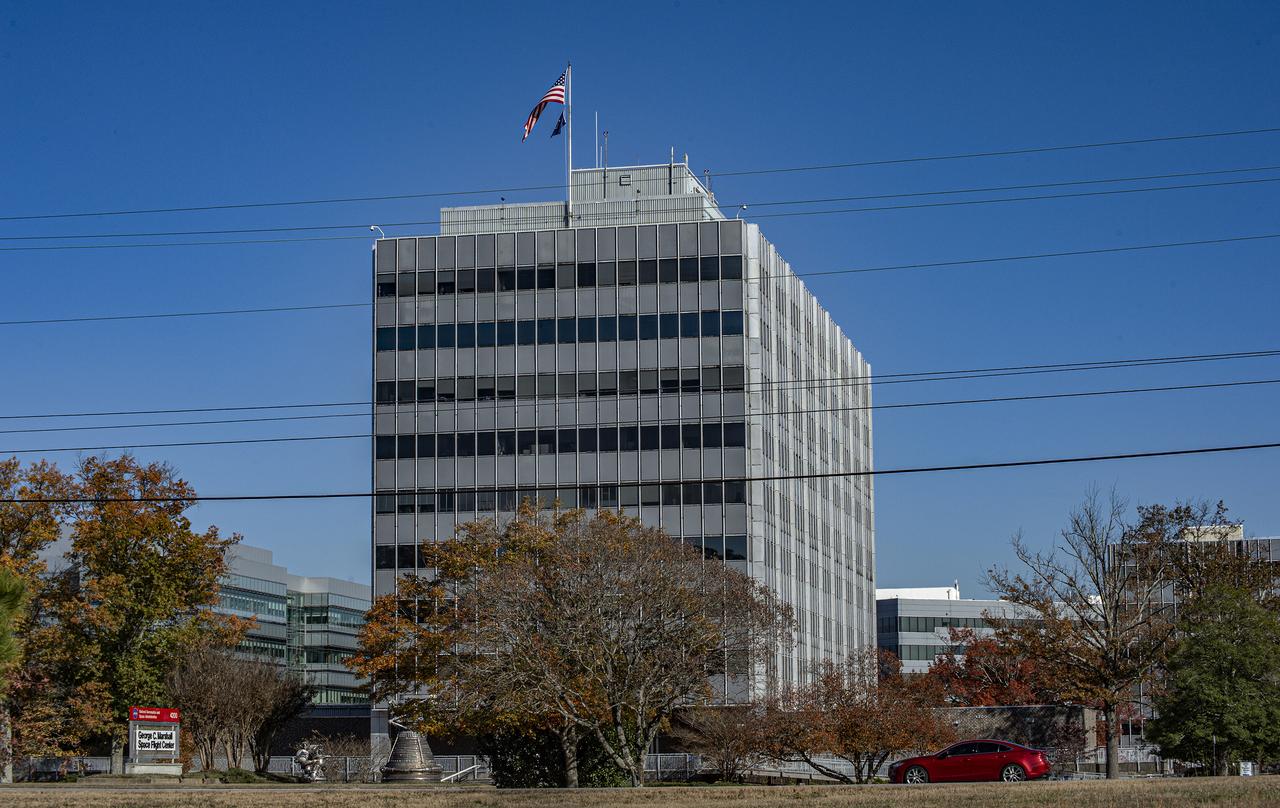
SEASONAL VIEWS, FALL, (NOVEMBER 13, 2019), OF MSFC BUILDING 4200
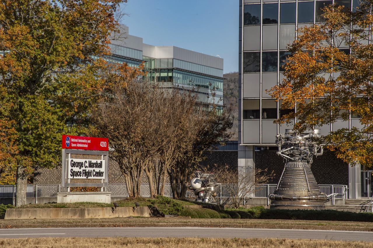
SEASONAL VIEWS, FALL, (NOVEMBER 13, 2019), OF MSFC BUILDING 4200
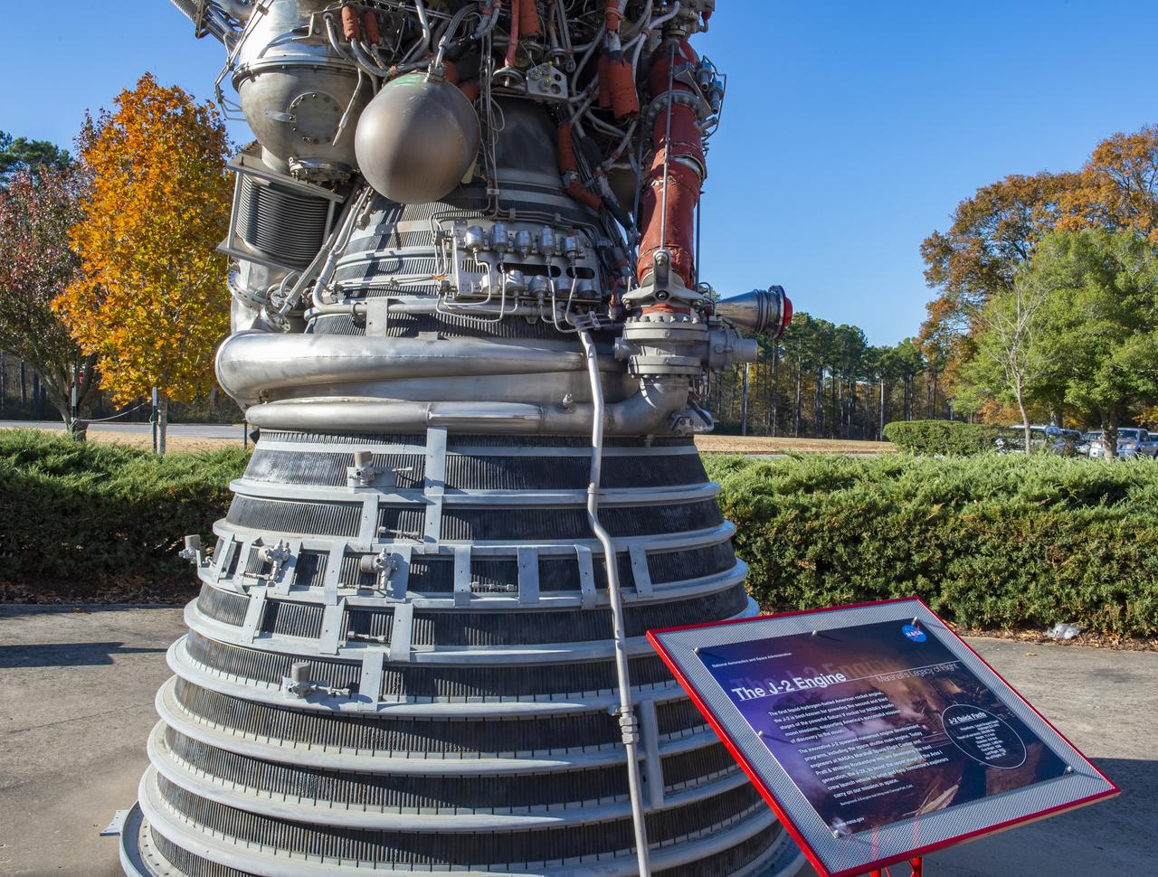
SEASONAL VIEWS, FALL, (NOVEMBER 13, 2019), OF MSFC BUILDING 4200
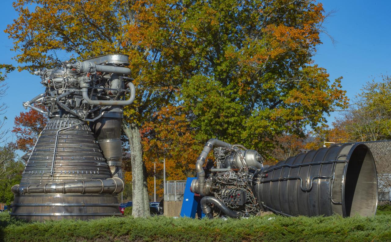
SEASONAL VIEWS, FALL, (NOVEMBER 13, 2019), OF MSFC BUILDING 4200

SEASONAL VIEWS, FALL, (NOVEMBER 13, 2019), OF MSFC BUILDING 4200
SEASONAL VIEWS, FALL, (NOVEMBER 13, 2019), OF MSFC BUILDING 4200
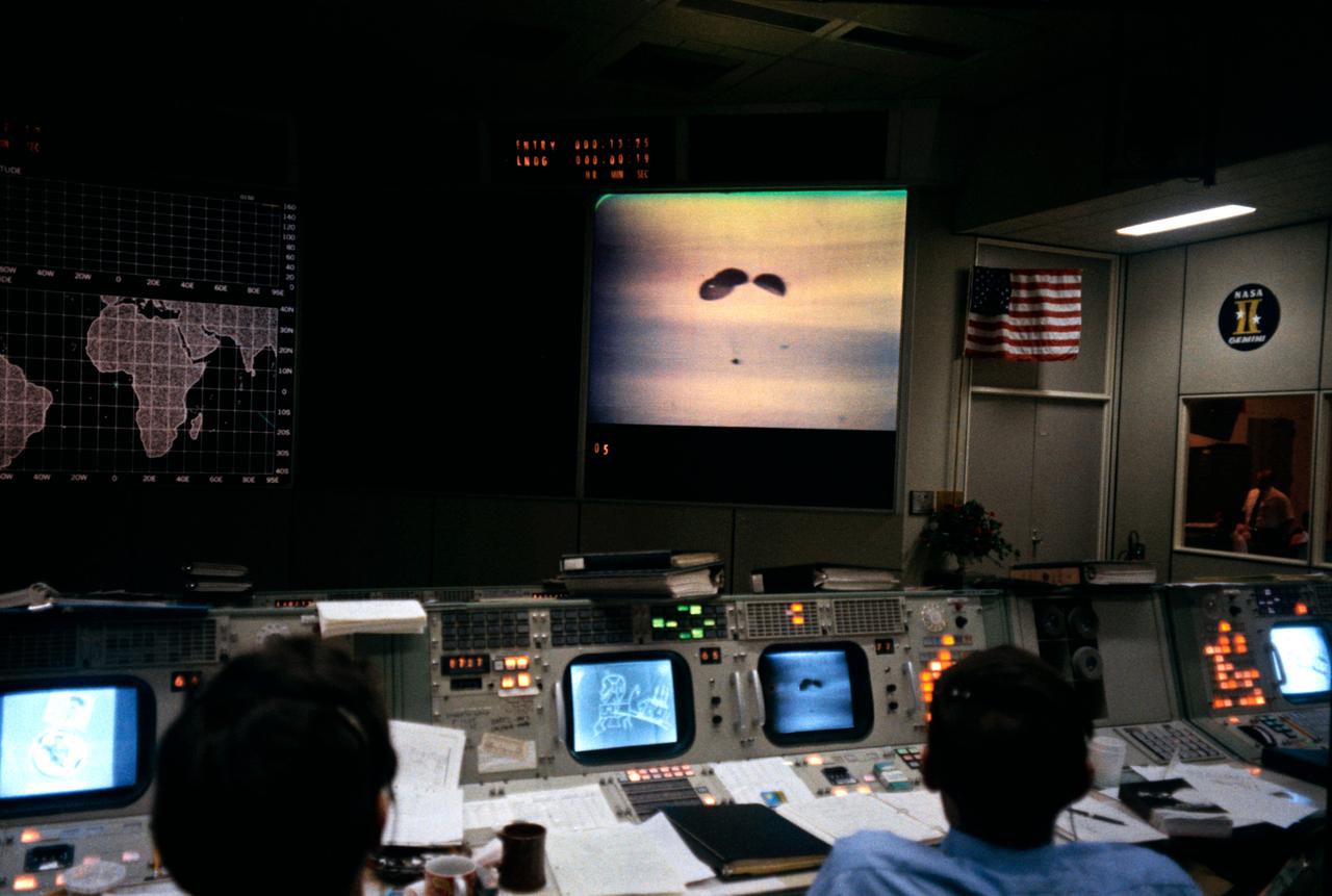
S70-35471 (17 April 1970) --- Two flight controllers man consoles in the Missions Operations Control Room (MOCR) of the Mission Control Center (MCC) at the Manned Spacecraft Center (MSC), Houston, Texas, just before splashdown occurred in the south Pacific Ocean. Though the MOCR does not appear to be crowded in this photo, there was a very large crowd of persons on hand for the splashdown and recovery operations coverage. Most of the group crowded around in the rear of the room. Apollo 13 splashdown occurred at 12:07:44 p.m. (CST), April 17, 1970.
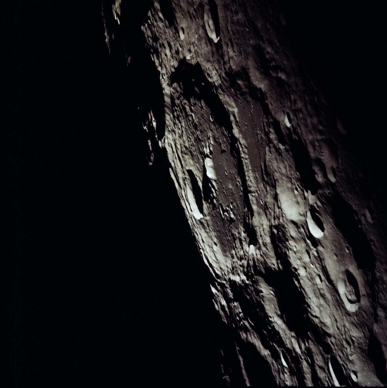
AS13-60-8635 (April 1970) --- An oblique view of the International Astronomical Union Crater No. 302 on the lunar farside as photographed from the Apollo 13 spacecraft during its pass around the moon. This large crater is located at 162 degrees east longitude and 10 degrees south latitude. The smaller crater, I.A.U. No. 301, is in the foreground. I.A.U. No. 302 has ridges in its center and a smaller crater near its inner edge. This view is looking southeast.
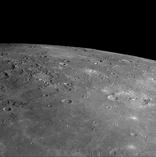
AS13-60-8659 (14 April 1970) --- Excellent view of the lunar farside showing the crater Tsiolkovsky, as photographed by the crew of the Apollo 13 mission during their lunar pass. The view is looking southeast toward the lunar horizon. The approximate coordinates of Tsiolkovsky are 128.5 degrees east longitude and 20.5 degrees south latitude. The Apollo 13 crew members were forced to cancel their scheduled lunar landing because of an apparent explosion of oxygen tank number two in the Service Module (SM).
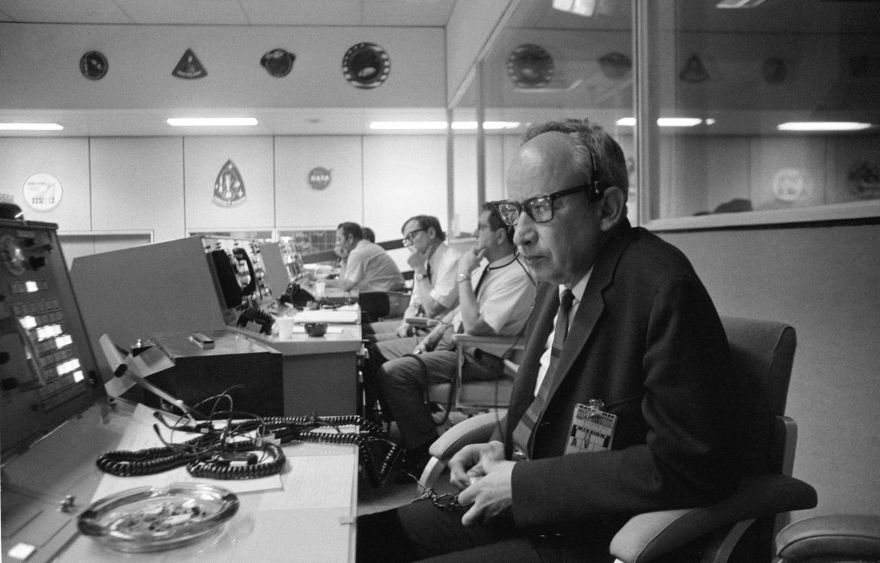
S70-34627 (11 April 1970) --- Sigurd A. Sjoberg, director of flight operations, at the Manned Spacecraft Center (MSC), views the Apollo 13 liftoff from a console in the MSC Mission Control Center (MCC), Building 30. Apollo 13 lifted off at 1:13 p.m. (CST) April 11, 1970. Photo credit: NASA
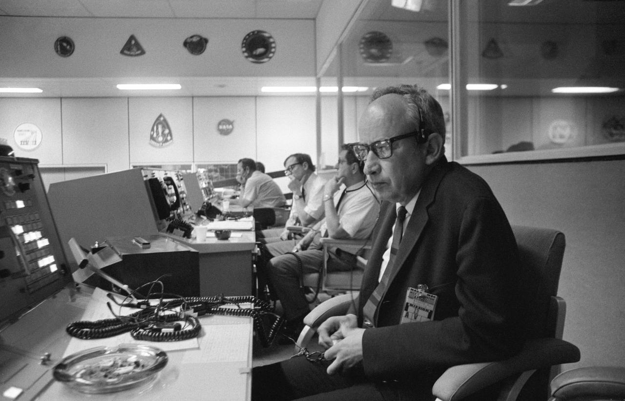
S70-34627 (11 April 1970) --- Sigurd A. Sjoberg, director of flight operations, at the Manned Spacecraft Center (MSC), views the Apollo 13 liftoff from a console in the MSC Mission Control Center (MCC), Building 30. Apollo 13 lifted off at 1:13 p.m. (CST) April 11, 1970. Photo credit: NASA

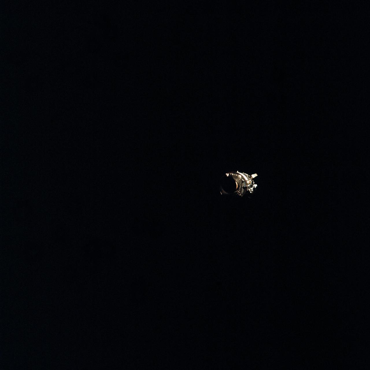
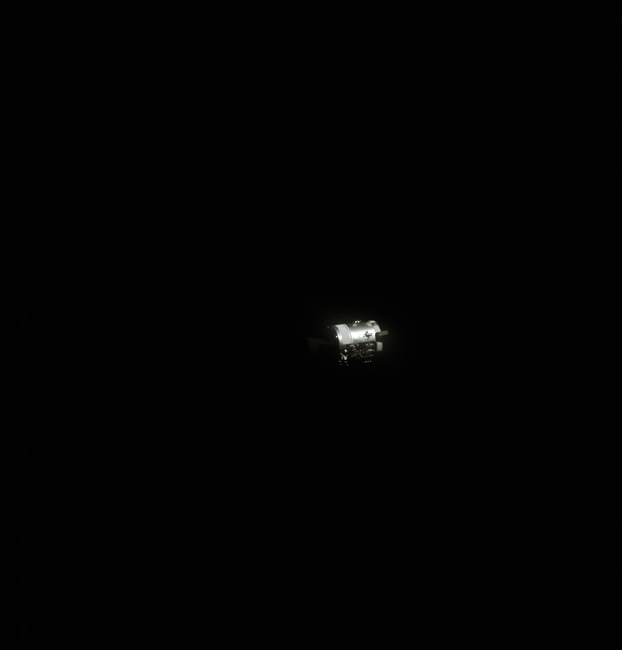
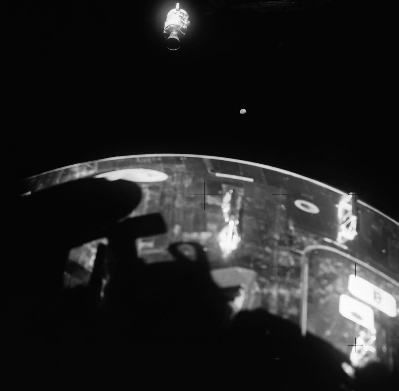
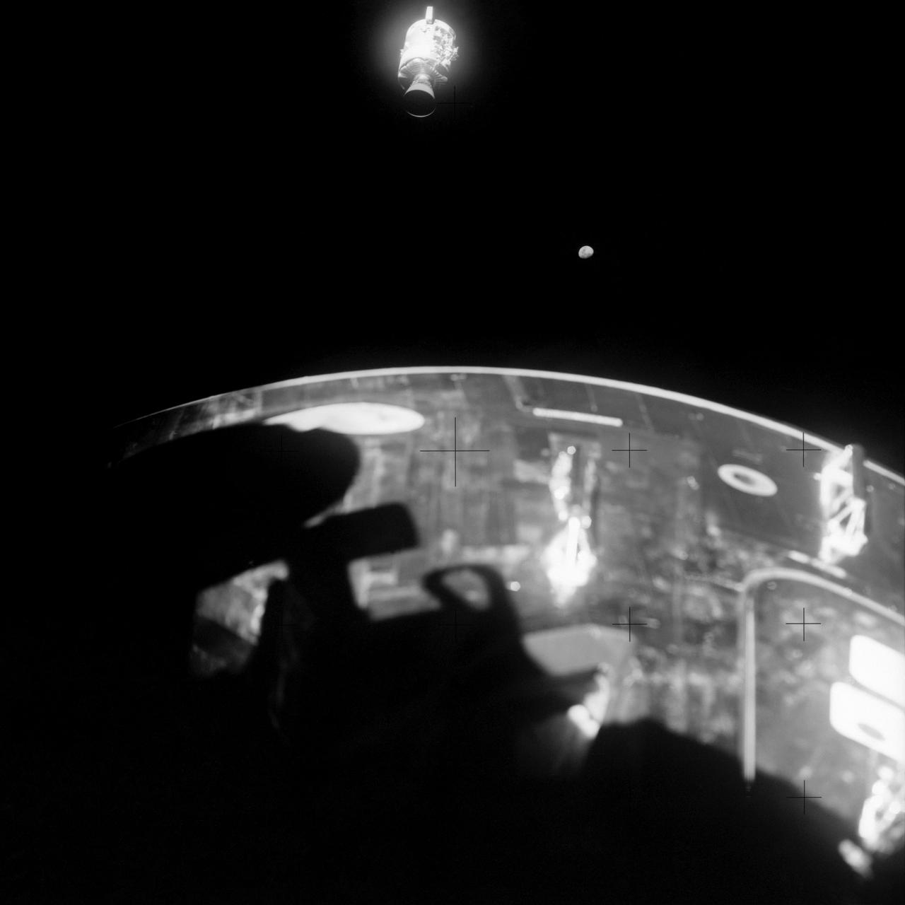
AS13-59-8562 (17 April 1970) --- This view of the Apollo 13 Lunar Module (LM) was photographed from the Command Module (CM) just after the LM had been jettisoned. The jettisoning occurred a few minutes before 11 a.m. (CST), April 17, 1970, just over an hour prior to splashdown of the CM in the south Pacific Ocean. The apparent explosion of oxygen tank number two in the Apollo 13 Service Module (SM) caused the Apollo 13 crew members to rely on the LM as a "lifeboat".

S70-35368 (16 April 1970) --- Overall view showing some of the feverish activity in the Mission Operations Control Room (MOCR) of the Mission Control Center (MCC) during the final 24 hours of the problem-plagued Apollo 13 mission. Here, flight controllers and several NASA/MSC officials confer at the flight director's console. When this picture was made, the Apollo 13 lunar landing had already been canceled, and the Apollo 13 crewmembers were in trans-Earth trajectory attempting to bring their crippled spacecraft back home.
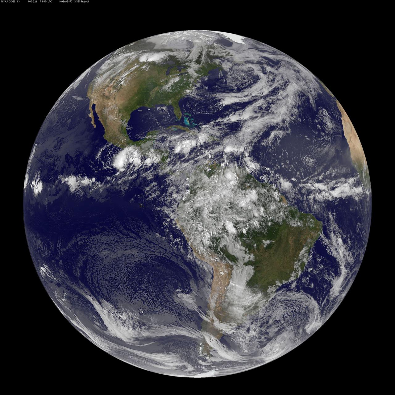
NASA GOES 13 satellite image showing earth on May 28, 2010 11:45 UTC. <b><a href="http://goes.gsfc.nasa.gov/" rel="nofollow">Credit: NOAA/NASA GOES Project</a><b> <b><a href="http://www.nasa.gov/centers/goddard/home/index.html" rel="nofollow">NASA Goddard Space Flight Center</a></b> is home to the nation's largest organization of combined scientists, engineers and technologists that build spacecraft, instruments and new technology to study the Earth, the sun, our solar system, and the universe. <b>Follow us on <a href="http://twitter.com/NASA_GoddardPix" rel="nofollow">Twitter</a></b> <b>Join us on <a href="http://www.facebook.com/pages/Greenbelt-MD/NASA-Goddard/395013845897?ref=tsd" rel="nofollow">Facebook</a></b></b></b>
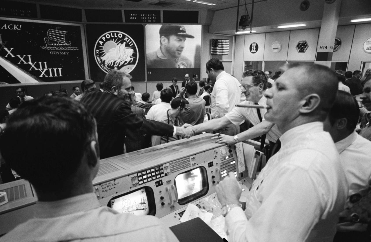
S70-35145 (17 April 1970) --- Overall view of Mission Operations Control Room in Mission Control Center at the Manned Spacecraft Center (MSC) during the ceremonies aboard the USS Iwo Jima, prime recovery ship for the Apollo 13 mission. Dr. Donald K. Slayton (in black shirt, left of center), director of Flight Crew Operations at MSC, and Chester M. Lee of the Apollo Program Directorate, Office of Manned Space Flight, NASA Headquarters, shake hands, while Dr. Rocco A. Petrone, Apollo program director, Office of Manned Space Flight, NASA Headquarters (standing, near Lee), watches the large screen showing astronaut James A. Lovell Jr., Apollo 13 commander, during the onboard ceremonies. In the foreground, Glynn S. Lunney (extreme left) and Eugene F. Kranz (smoking a cigar), two Apollo 13 flight directors, view the activity from their consoles.

S70-35145 (17 April 1970) --- Overall view of Mission Operations Control Room in Mission Control Center at the Manned Spacecraft Center (MSC) during the ceremonies aboard the USS Iwo Jima, prime recovery ship for the Apollo 13 mission. Dr. Donald K. Slayton (in black shirt, left of center), director of Flight Crew Operations at MSC, and Chester M. Lee of the Apollo Program Directorate, Office of Manned Space Flight, NASA Headquarters, shake hands, while Dr. Rocco A. Petrone, Apollo program director, Office of Manned Space Flight, NASA Headquarters (standing, near Lee), watches the large screen showing astronaut James A. Lovell Jr., Apollo 13 commander, during the onboard ceremonies. In the foreground, Glynn S. Lunney (extreme left) and Eugene F. Kranz (smoking a cigar), two Apollo 13 flight directors, view the activity from their consoles.
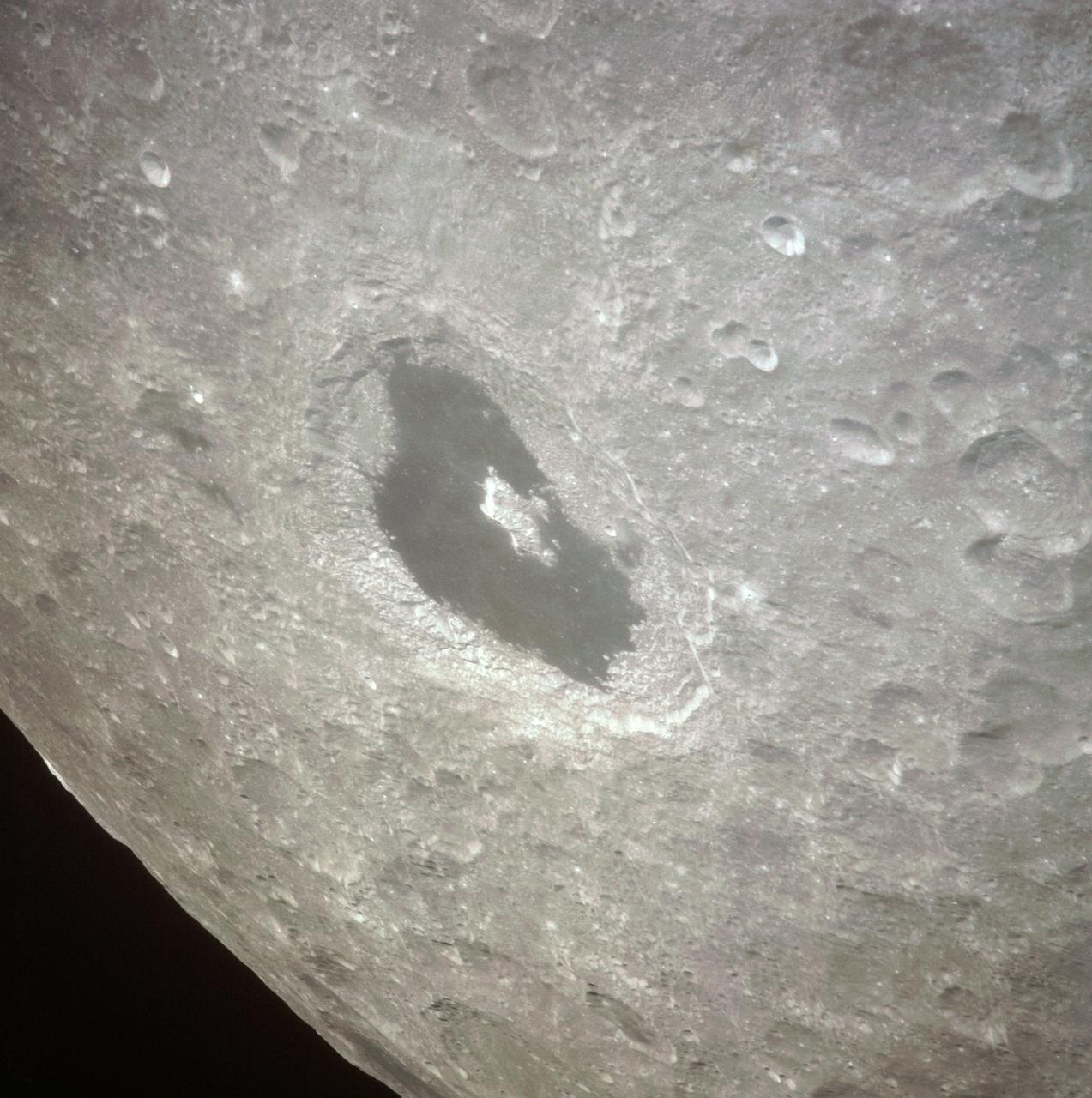
AS13-60-8675 (April 1970) --- This bright-rayed crater on the lunar farside was photographed from the Apollo 13 spacecraft during its pass around the moon. This area is northeast of Mare Marginus. The bright-rayed crater is located at about 105 degrees east longitude and 45 degrees north latitude. The crater Joliot-Curie is located between Mare Marginus and the rayed crater. This view is looking generally toward the northeast.
AS13-58-8458 (17 April 1970) --- This view of the severely damaged Apollo 13 Service Module (SM) was photographed from the Lunar Module/Command Module (LM/CM) following SM jettisoning. An entire SM panel was blown away by the apparent explosion of oxygen tank number two. Two of the three fuel cells are visible at the forward portion of the opening. The hydrogen tanks are located in Sector 4 of the Apollo 13 SM. The apparent rupture of the oxygen tank caused the Apollo 13 crew members to use the LM as a "lifeboat." The LM was jettisoned just prior to Earth re-entry by the CM.
AS13-58-8464 (17 April 1970) --- This view of the severely damaged Apollo 13 Service Module (SM) was photographed from the Lunar Module/Command Module (LM/CM) following SM jettisoning. Nearest the camera is the Service Propulsion System (SPS) engine and nozzle. An entire SM panel was blown away by the apparent explosion of oxygen tank number two located in Sector 4 of the SM. The apparent rupture of the oxygen tank caused the Apollo 13 crew men to use the Lunar Module (LM) as a "lifeboat".
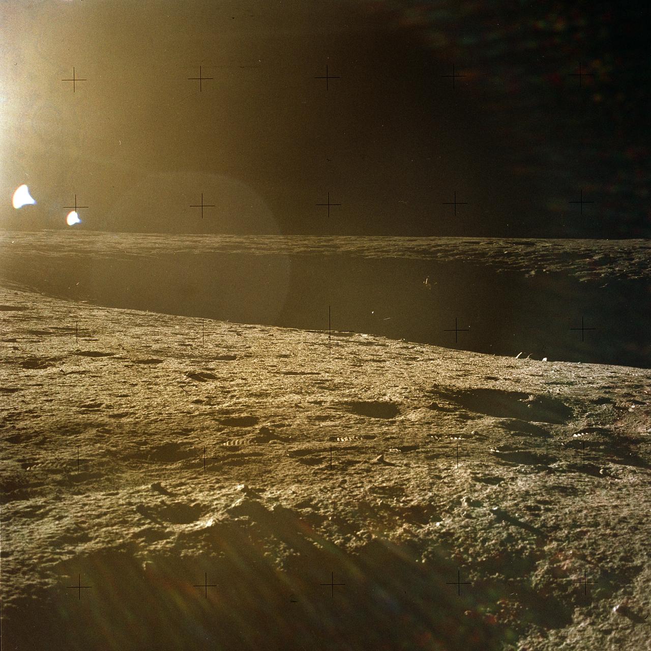
The second manned lunar landing mission, Apollo 12, launched from launch pad 39-A at Kennedy Space Center in Florida on November 14, 1969 via a Saturn V launch vehicle. The Saturn V vehicle was developed by the Marshall Space Flight Center (MSFC) under the direction of Dr. Wernher von Braun. Aboard Apollo 12 was a crew of three astronauts: Alan L. Bean, pilot of the Lunar Module (LM), Intrepid; Richard Gordon, pilot of the Command Module (CM), Yankee Clipper; and Spacecraft Commander Charles Conrad. The LM, Intrepid, landed astronauts Conrad and Bean on the lunar surface in what’s known as the Ocean of Storms while astronaut Richard Gordon piloted the CM, Yankee Clipper, in a parking orbit around the Moon. Lunar soil activities included the deployment of the Apollo Lunar Surface Experiments Package (ALSEP), finding the unmanned Surveyor 3 that landed on the Moon on April 19, 1967, and collecting 75 pounds (34 kilograms) of rock samples. This is the thirteenth of 25 images captured by the crew in attempt to provide a 360 degree Lunar surface scene. Apollo 12 safely returned to Earth on November 24, 1969.
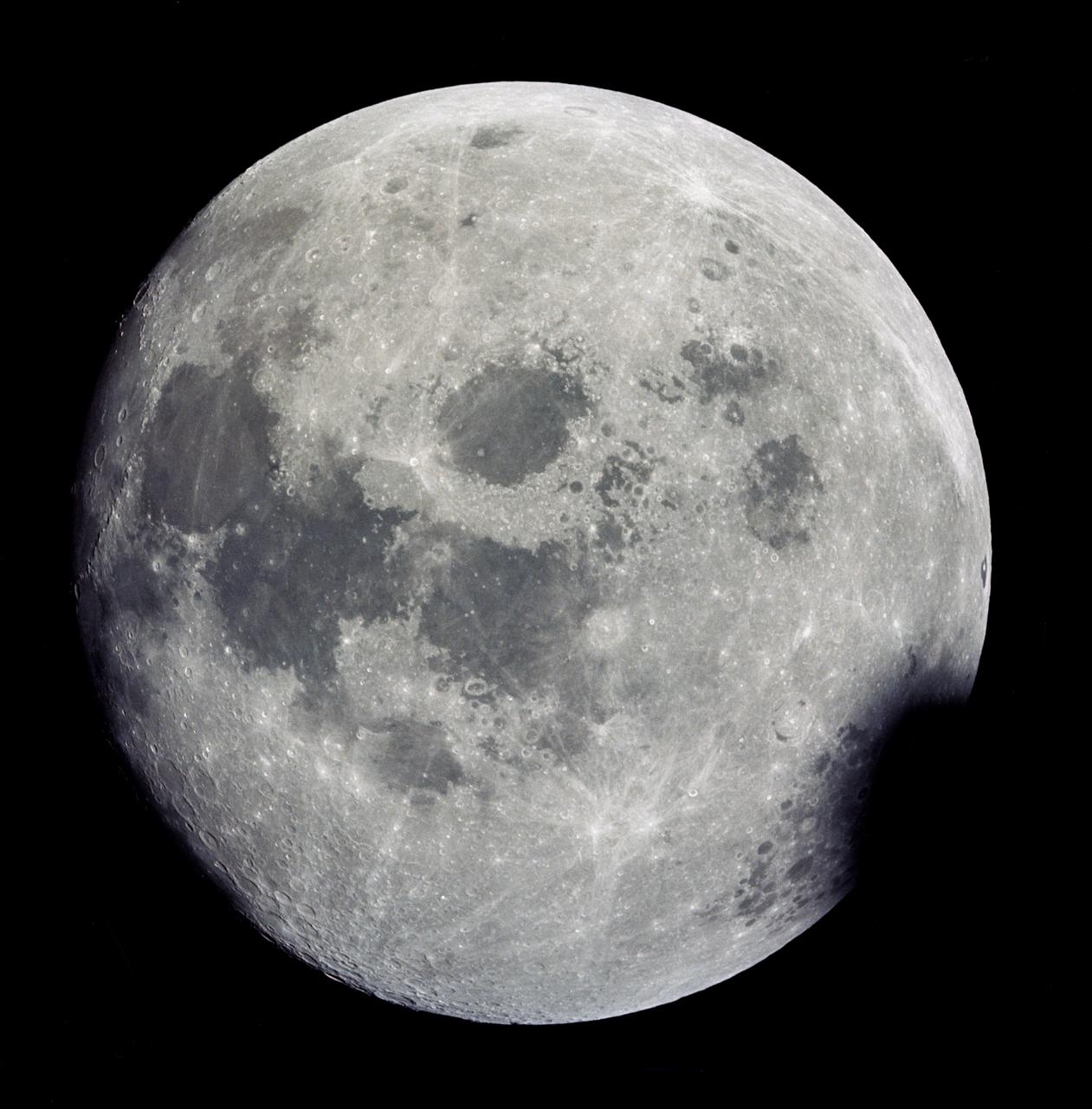
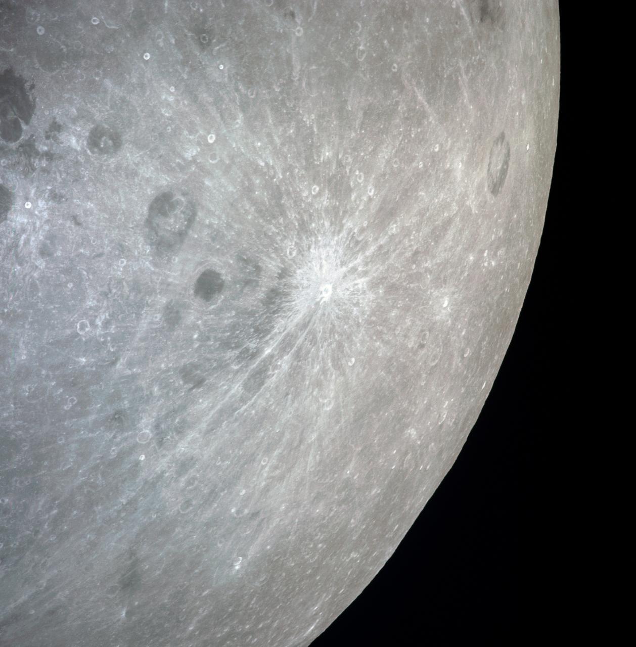
AS13-60-8703 (11-17 April 1970) --- This outstanding view of a near full moon was photographed from the Apollo 13 spacecraft during its trans-Earth journey homeward. Though the explosion of the oxygen tank in the Service Module (SM) forced the cancellation of the scheduled lunar landing, Apollo 13 made a pass around the moon prior to returning to Earth. Some of the conspicuous lunar features include the Sea of Crisis, the Sea of Fertility, the Sea of Tranquility, the Sea of Serenity, the Sea of Nectar, the Sea of Vapors, the Border Sea, Smyth's Sea, the crater Langrenus, and the crater Tsiolkovsky.
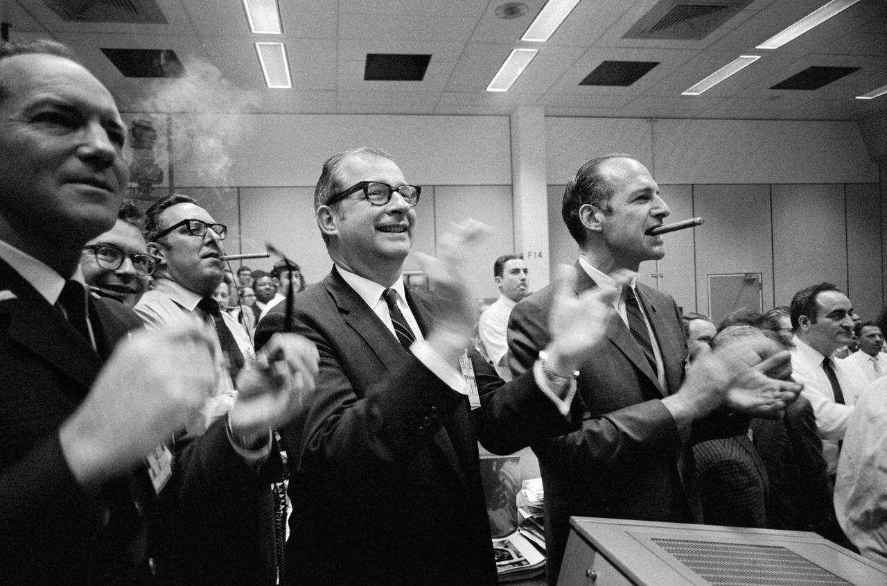
S70-35148 (17 April 1970) --- Staff members from NASA Headquarters (NASA HQ), Manned Spacecraft Center (MSC), and Dr. Thomas Paine (center of frame) applaud the successful splashdown of the Apollo 13 mission while Dr. George Low smokes a cigar (right), in the MSC Mission Control Center (MCC), located in Building 30. Apollo 13 crewmembers, astronauts James A. Lovell Jr., commander; John L. Swigert Jr., command module pilot; and Fred W. Haise Jr., lunar module pilot, splashed down at 12:07:44 p.m. (CST), April 17, 1970, in the south Pacific Ocean.
This view of the damaged Apollo 13 Service Module (SM) was photographed from the Lunar Module/Command Module following SM jettisoning. As seen here, an entire panel on the SM was blown away by the apparent explosion of oxygen tank number two located in Sector 4 of the SM. Two of the three fuel cells are visible just forward (above) the heavily damaged area. Three fuel cells, two oxygen tanks, and two hydrogen tanks are locate in Sector 4. The damaged area is located above the S-band high gain antenna. Nearest the camera is the Service Propulsion System (SPS) engine and nozzle. The damage to the SM caused the Apollo 13 crewmen to use the Lunar Module (LM) as a "lifeboat". The LM was jettisoned just prior to Earth reentry by the Command Module.
AS13-59-8501 (17 April 1970) --- This view of the severely damaged Apollo 13 Service Module (SM) was photographed from the Lunar Module/Command Module (LM/CM) following SM jettisoning. As seen here, an entire panel on the SM was blown away by the apparent explosion of oxygen tank number two located in Sector 4 of the SM. Two of the three fuel cells are visible just forward (above) the heavily damaged area. Three fuel cells, two oxygen tanks, and two hydrogen tanks are located in Sector 4. The damaged area is located above the S-Band high gain antenna. Nearest the camera is the Service Propulsion System (SPS) engine and nozzle. The damage to the SM caused the Apollo 13 crew men to use the LM as a "lifeboat." The LM was jettisoned just prior to Earth re-entry by the CM.
This view in the southern constellation Carina was acquired on December 13, 2007 as part of the characterization tests of the Framing Camera. The false-color view is a composite of images at 430 nm violet, 650 nm red, and 980 nm infrared.
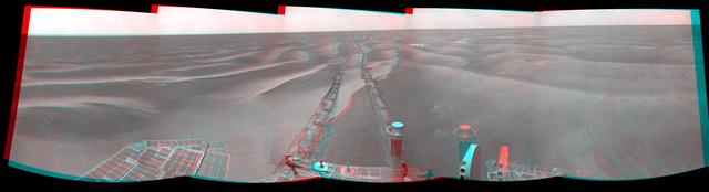
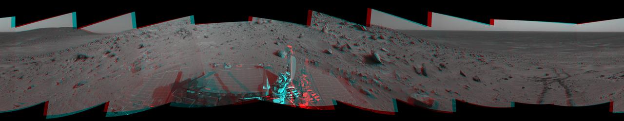
NASA Mars Exploration Rover Opportunity used its navigation camera to take the images combined into this stereo 180-degree view on Feb. 13, 2009. 3D glasses are necessary to view this image.
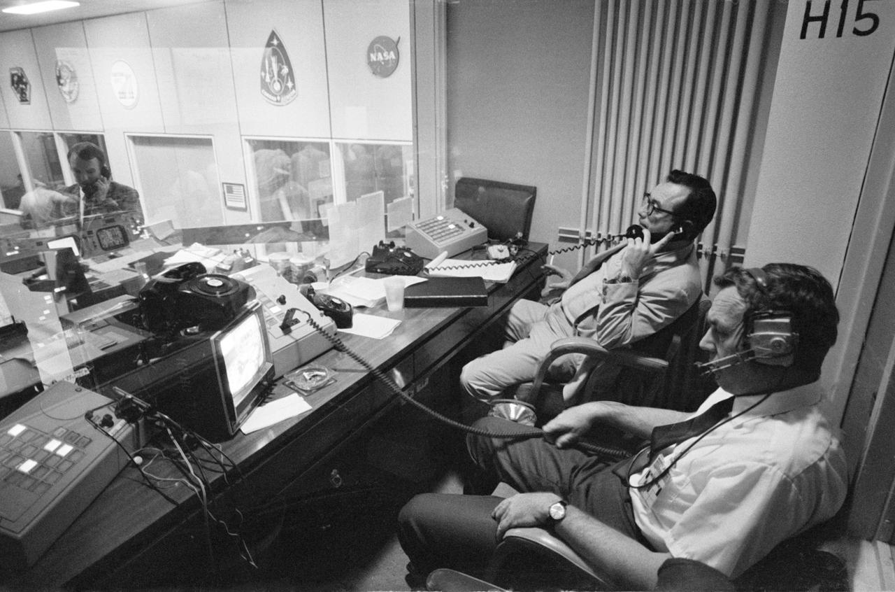
S70-35012 (15 April 1970) --- Two phases of busy activity during critical moments of the Apollo 13 mission are reflected in this view in the Mission Control Center, Building 30, Manned Spacecraft Center. In the foreground, Henry Simmons (left) of Newsweek magazine and John E. Riley, public information specialist, Public Affairs Office, MSC, man their positions in the Press Room. At extreme left of photo, Gerald D. Griffin, Shift 2 flight director, talks on telephone in Mission Operations Control Room. When this photograph was taken, the Apollo 13 lunar landing had been canceled, and the problem-plagued Apollo 13 crewmen were in trans-Earth trajectory attempting to bring their crippled spacecraft back home.

This northeast-facing view from the lower edge of the pale Pahrump Hills outcrop at the base of Mount Sharp includes wind-sculpted ripples of sand and dust in the middle ground. It was taken by Curiosity Navcam on Nov. 13, 2014.
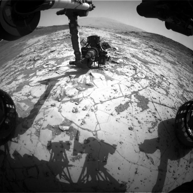
This view NASA Curiosity Mars Rover shows the rover drill in position for a mini-drill test to assess whether a rock target called Mojave is appropriate for full-depth drilling to collect a sample. It was taken on Jan. 13, 2015.
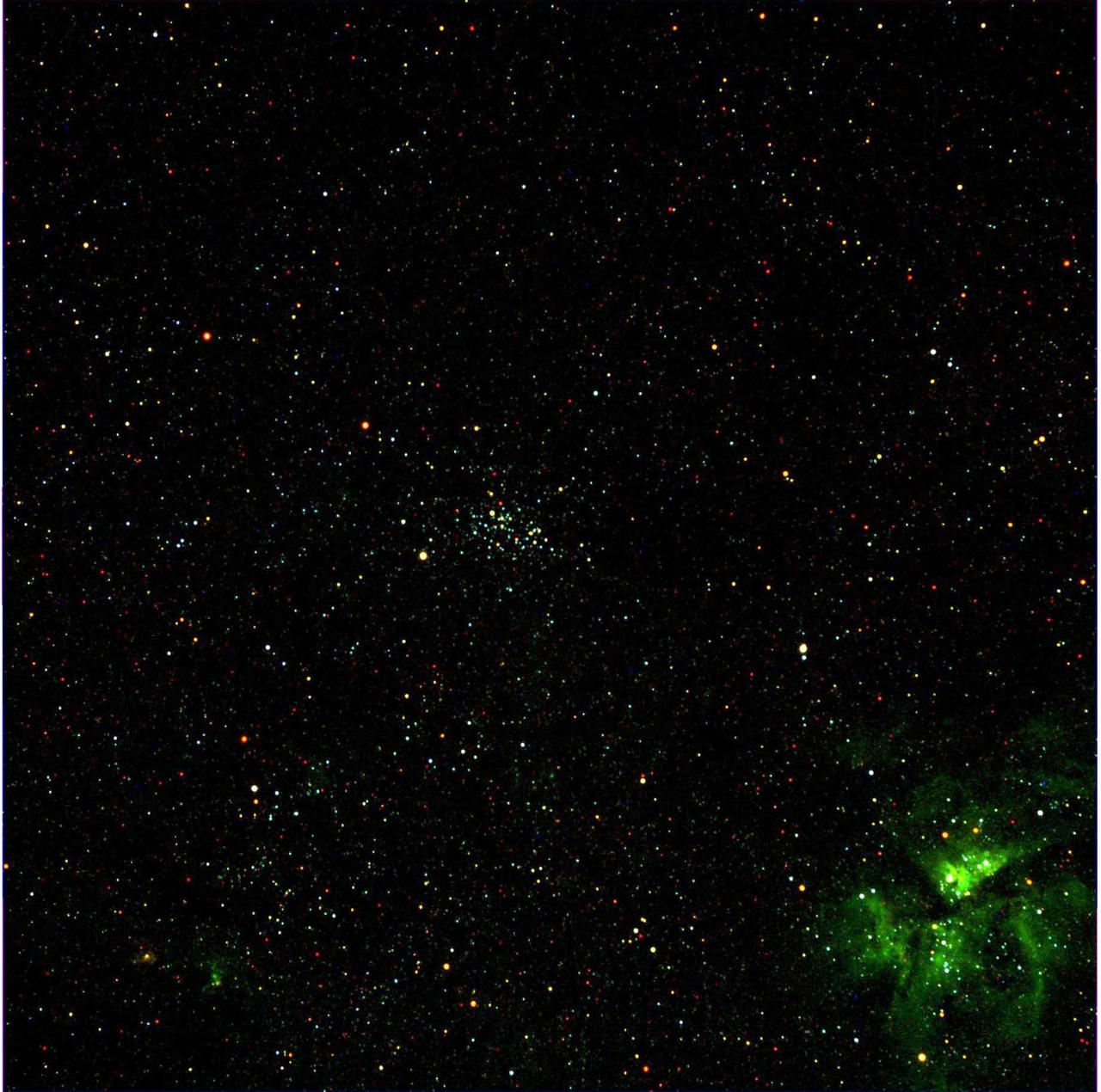
This view in the southern constellation Carina was acquired on December 13, 2007 as part of the characterization tests of the Framing Camera. The cluster of stars in the center is NGC 3532, and the nebula in the lower right is the Eta Carina Nebula.
On Feb. 4, 2005, NASA Mars Exploration Rover Spirit had driven about 13 meters 43 feet uphill toward Cumberland Ridge. 3D glasses are necessary to view this image.

What does Earth look like when viewed from Mars? At 13:00 GMT on 8 May 2003, NASA Mars Global Surveyor MGS Mars Orbiter Camera MOC had an opportunity to find out.
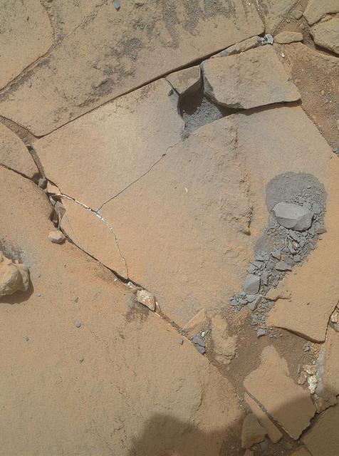
This Jan. 13, 2015, view from NASA Curiosity Mars rover shows outcomes of a mini-drill test to assess whether the Mojave rock is appropriate for full-depth drilling to collect a sample.

This view of Saturn's A ring features a lone "propeller" -- one of many such features created by small moonlets embedded in the rings as they attempt, unsuccessfully, to open gaps in the ring material. The image was taken by NASA's Cassini spacecraft on Sept. 13, 2017. It is among the last images Cassini sent back to Earth. The view was taken in visible light using the Cassini spacecraft wide-angle camera at a distance of 420,000 miles (676,000 kilometers) from Saturn. Image scale is 2.3 miles (3.7 kilometers). https://photojournal.jpl.nasa.gov/catalog/PIA21894
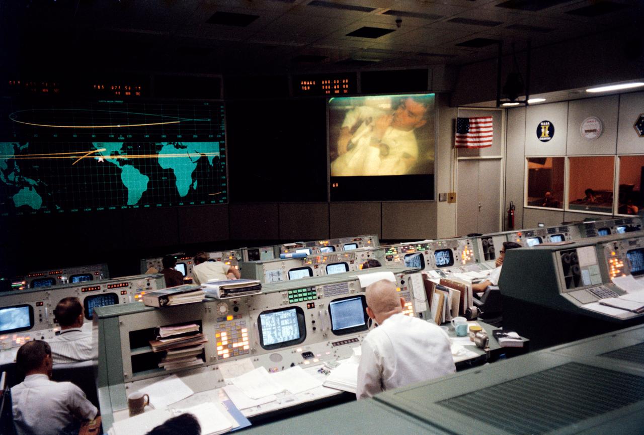
S70-35139 (13 April 1970) --- Overall view of the Mission Operations Control Room (MOCR) in the Mission Control Center (MCC) at Manned Spacecraft Center (MSC), during the fourth television transmission from the Apollo 13 mission in space. Eugene F. Kranz (foreground, back to camera), one of four Apollo 13 flight directors, views the large screen at front of MOCR, astronaut Fred W. Haise Jr., lunar module pilot, is seen on the screen. The fourth TV transmission from the Apollo 13 mission was on the evening of April 13, 1970.
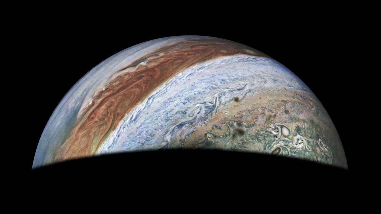
This view of Jupiter was captured by the JunoCam instrument aboard NASA's Juno spacecraft during the mission's 62nd close flyby of the giant planet on June 13, 2024. Citizen scientist Jackie Branc made the image using raw JunoCam data. https://photojournal.jpl.nasa.gov/catalog/PIA26350
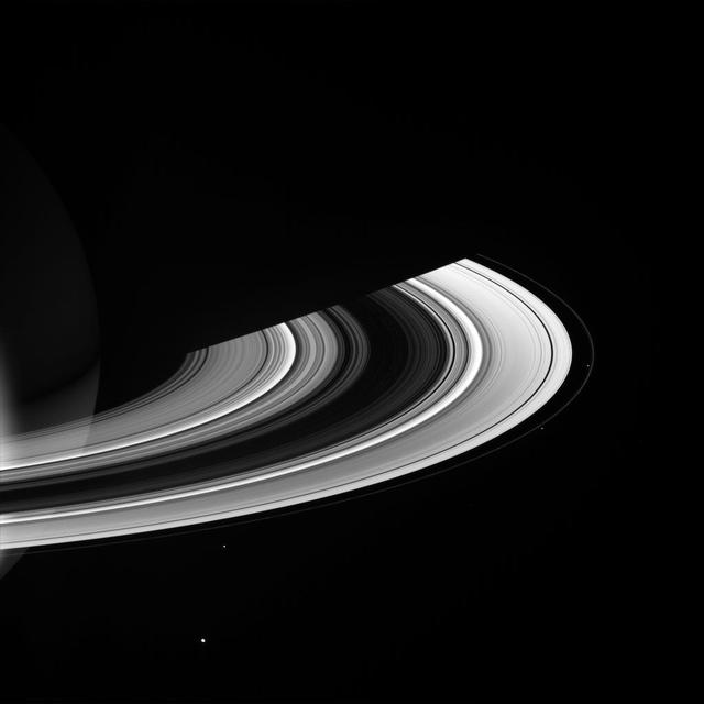
<p> The Cassini spacecraft looks toward the unilluminated side of Saturn rings to spy on the moon Pan as it cruises through the Encke Gap. </p> <p> This view looks toward the rings from about 13 degrees above the ringplane. At the top of the image
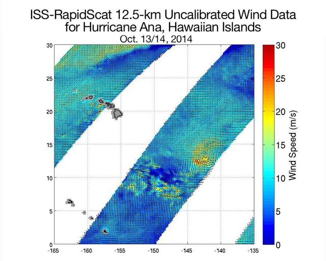
NASA ISS-RapidScat ocean wind scatterometer viewed Hurricane Ana as it approached Hawaii. From Oct. 13 to Oct. 19, 2014, RapidScat observed Ana seven times. This frame is from a movie containing multiple days of observation.

These two NASA Hubble Space Telescope images provide views of weather on opposite hemispheres of Neptune. Taken Aug. 13, 1996; these composite images blend information from different wavelengths to bring out features of Neptune blustery weather.
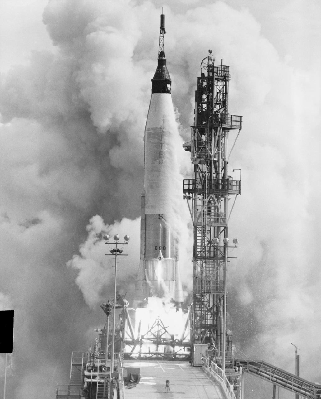
S61-03567 (13 Sept. 1961) --- View of the launch of Mercury-Atlas 4 (MA-4) spacecraft from Cape Canaveral, Florida on Sept. 13, 1961. Photo credit: NASA
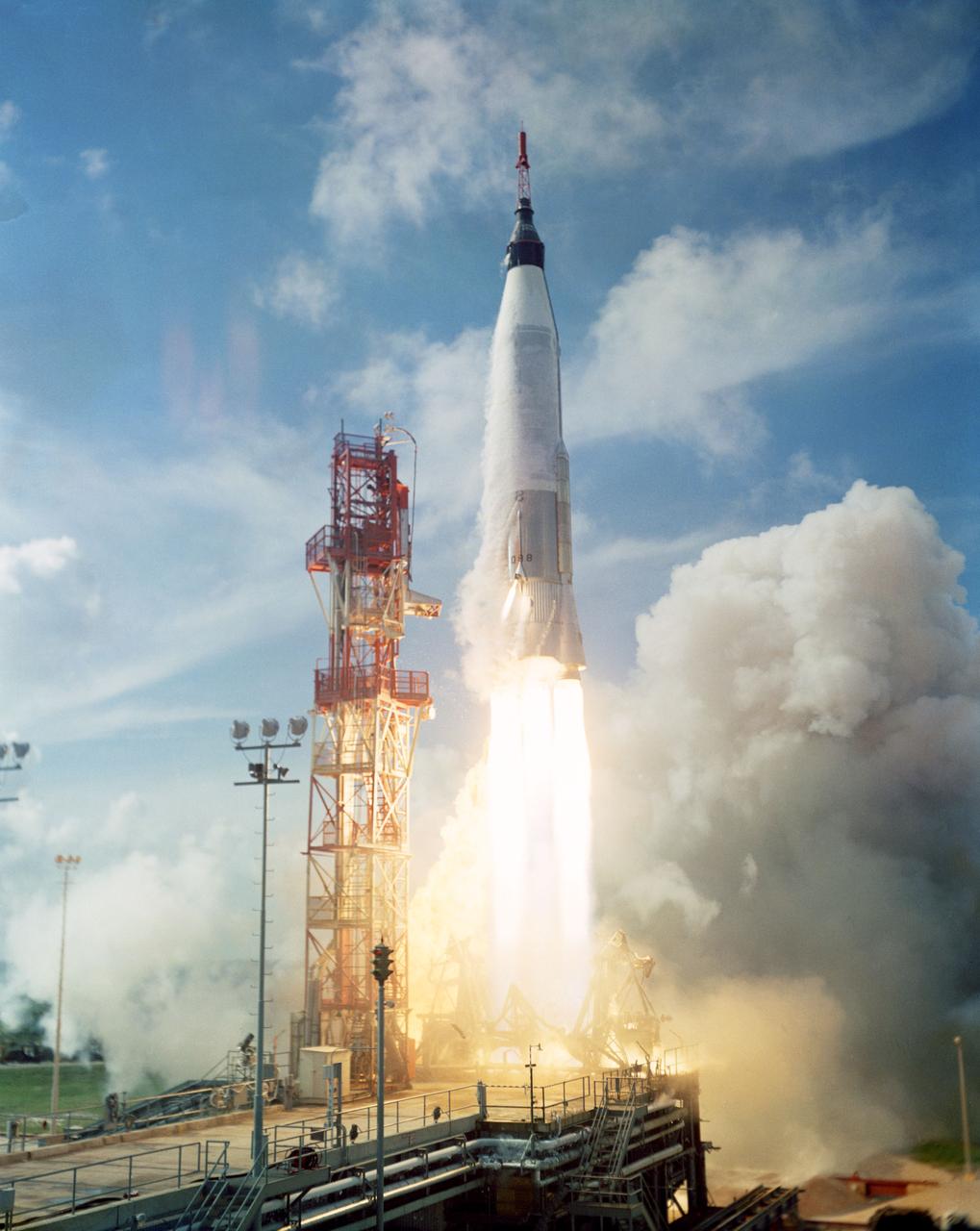
S61-03249 (13 Sept. 1961) --- View of the launch of the Mercury-Atlas 4 (MA-4) spacecraft from Cape Canaveral, Florida on Sept. 13, 1961. Photo credit: NASA

S61-03255 (13 Sept. 1961) --- View of the recovery of the Mercury-Atlas 4 (MA-4) spacecraft which was launched from Cape Canaveral, Florida on Sept. 13, 1961. Photo credit: NASA
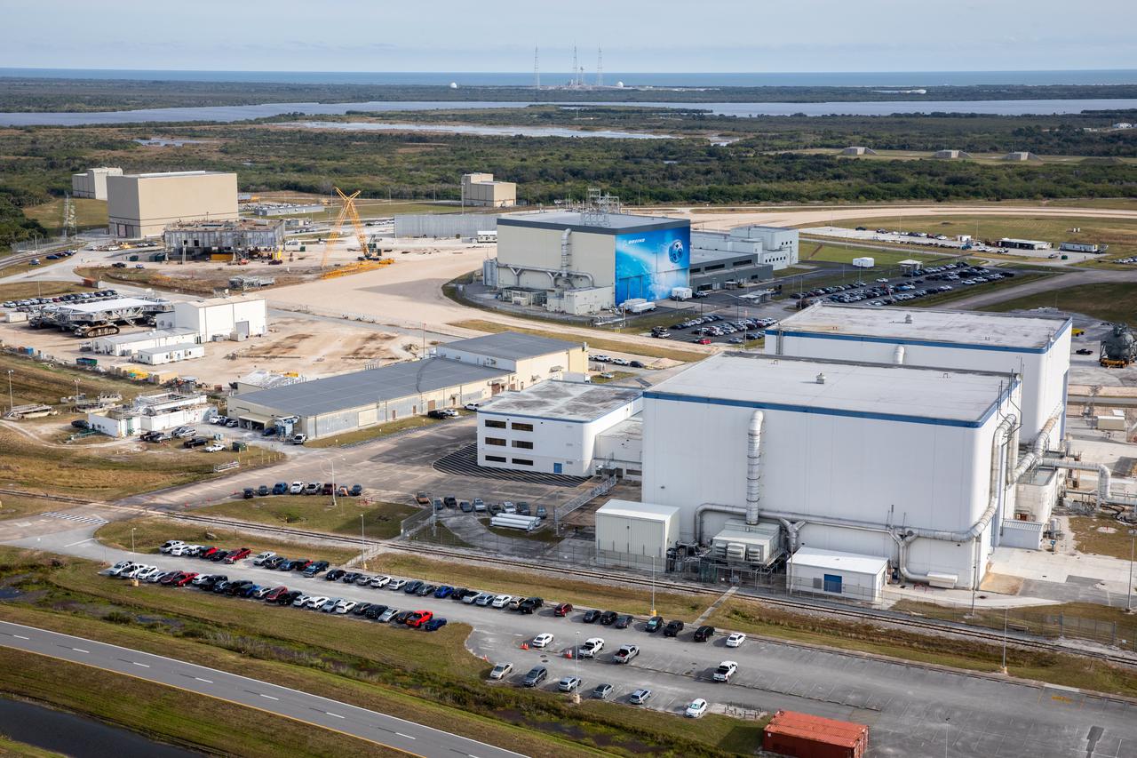
An aerial view of several processing facilities at NASA’s Kennedy Space Center in Florida on Jan. 13, 2021. In view in the background is Boeing’s Commercial Crew and Cargo Processing Facility.
S82-E-5147 (13 Feb. 1997) --- A front-lighted full view of the captured Hubble Space Telescope (HST) backdropped against a dark space background. This view was taken with an Electronic Still Camera (ESC).
An aerial view of several processing facilities at NASA’s Kennedy Space Center in Florida on Jan. 13, 2021. In view at right is Boeing’s Commercial Crew and Cargo Processing Facility.

View of OPF High Bay No. 1, Level 13 platform installation, July 8, 1977
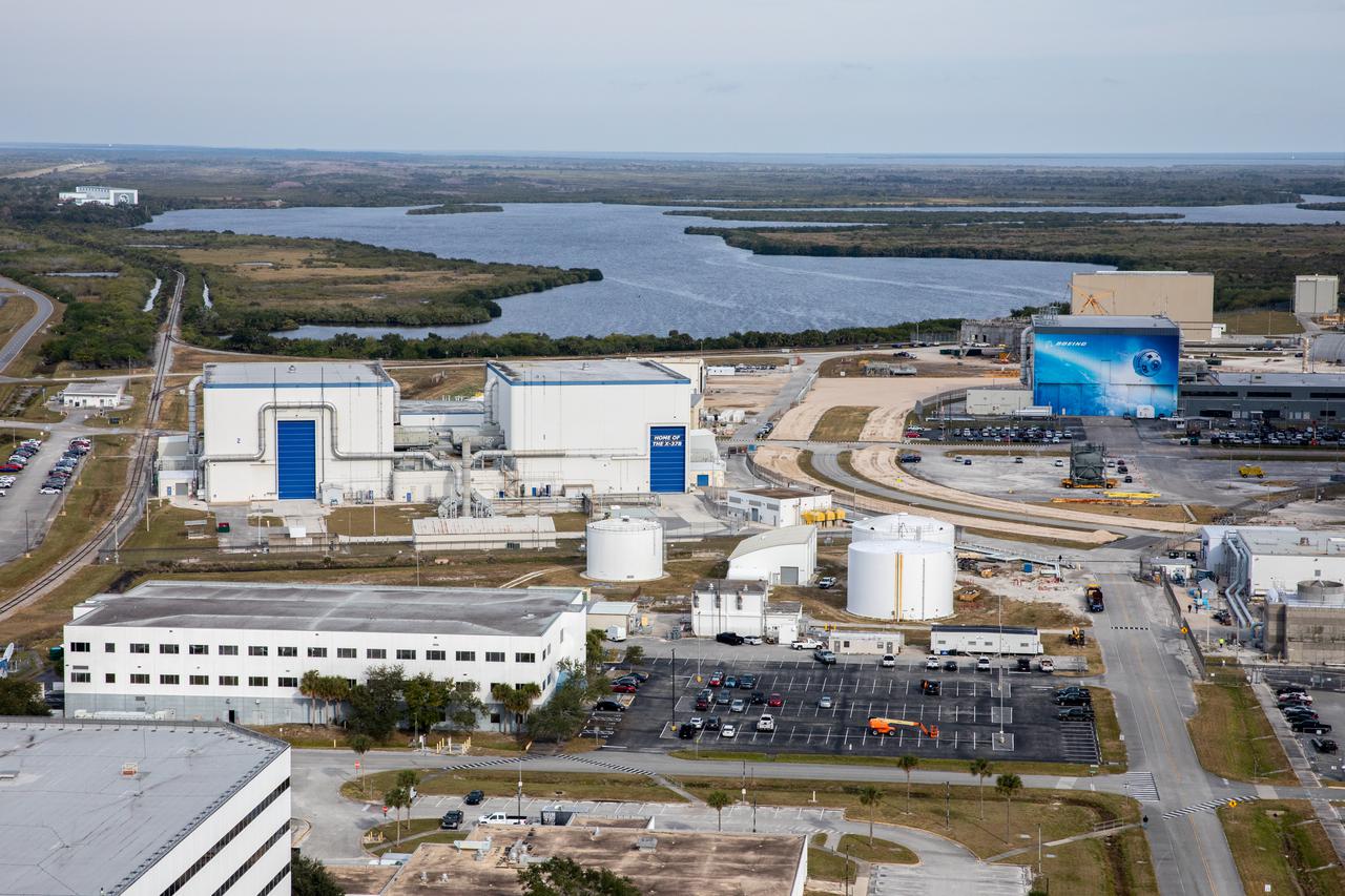
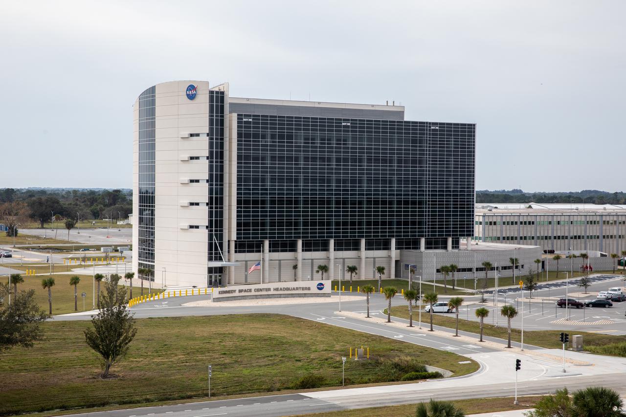
An aerial view of processing facilities at NASA’s Kennedy Space Center in Florida on Jan. 13, 2021.
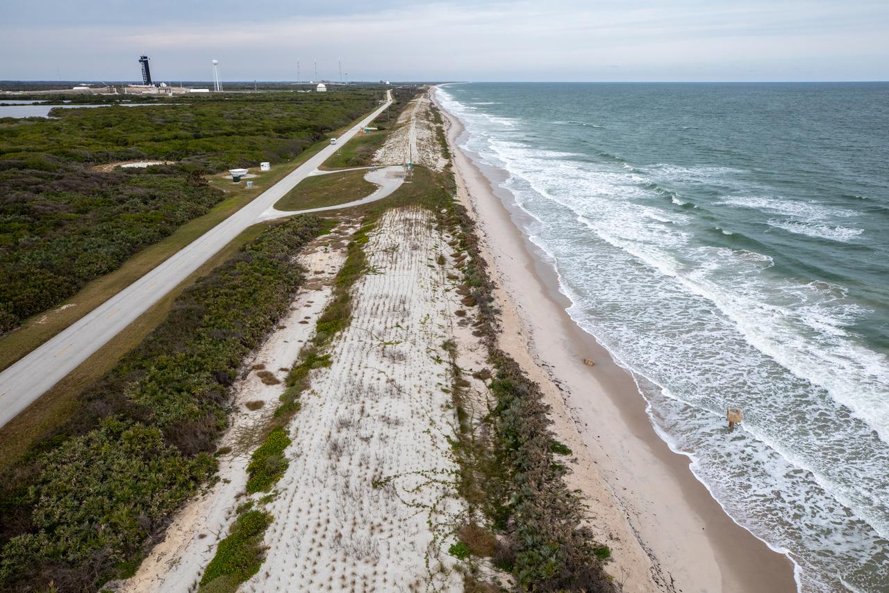
An aerial view of the Atlantic Ocean coastline and dunes along NASA’s Kennedy Space Center in Florida on Jan. 13, 2021.
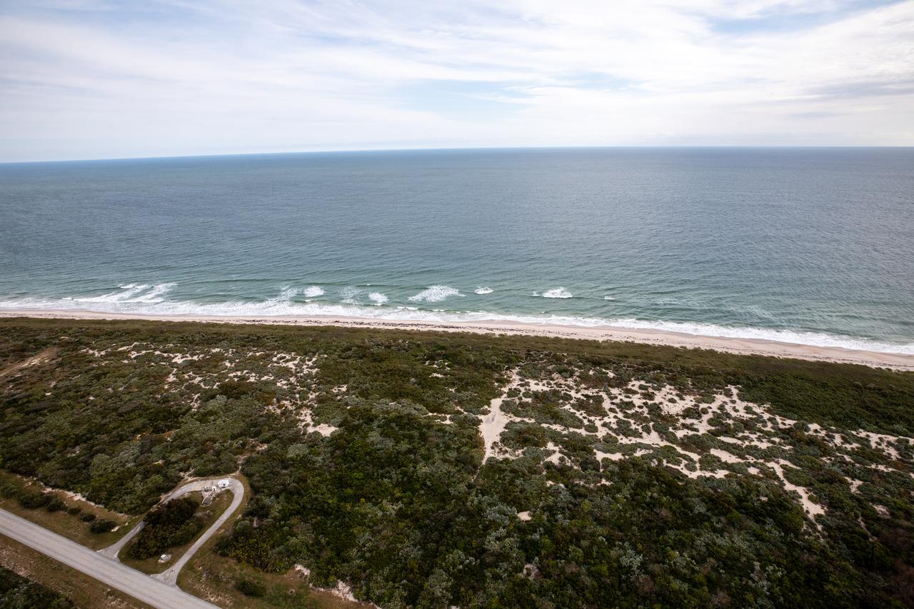
An aerial view of the Atlantic Ocean coastline and dunes along NASA’s Kennedy Space Center in Florida on Jan. 13, 2021.
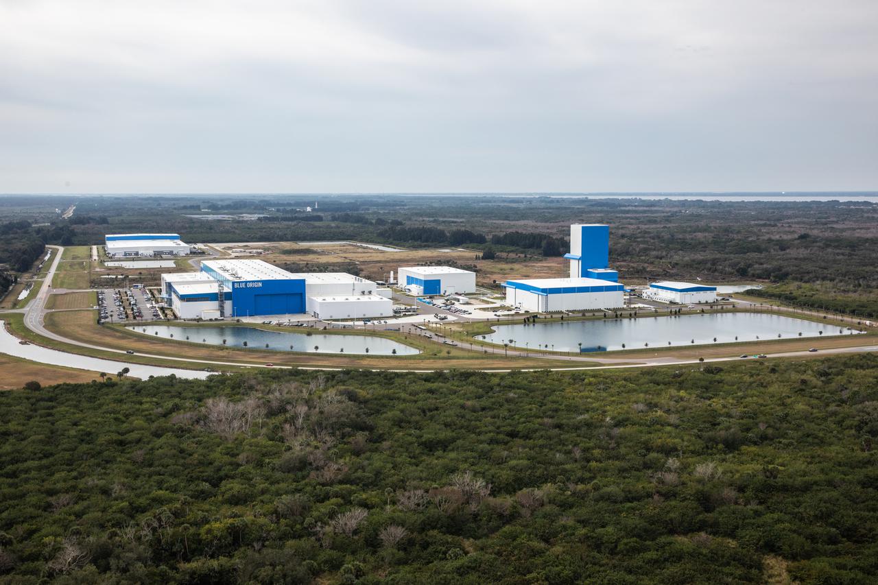
An aerial view of the Central Campus Headquarters Building in the industrial area at NASA’s Kennedy Space Center in Florida on Jan. 13, 2021.
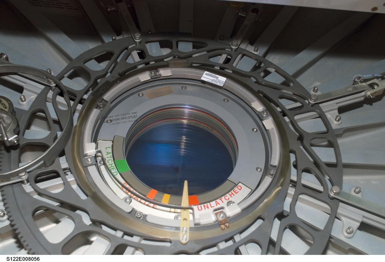
S122-E-008056 (13 February 2008) --- Closeup view of portal inside Columbus laboratory.
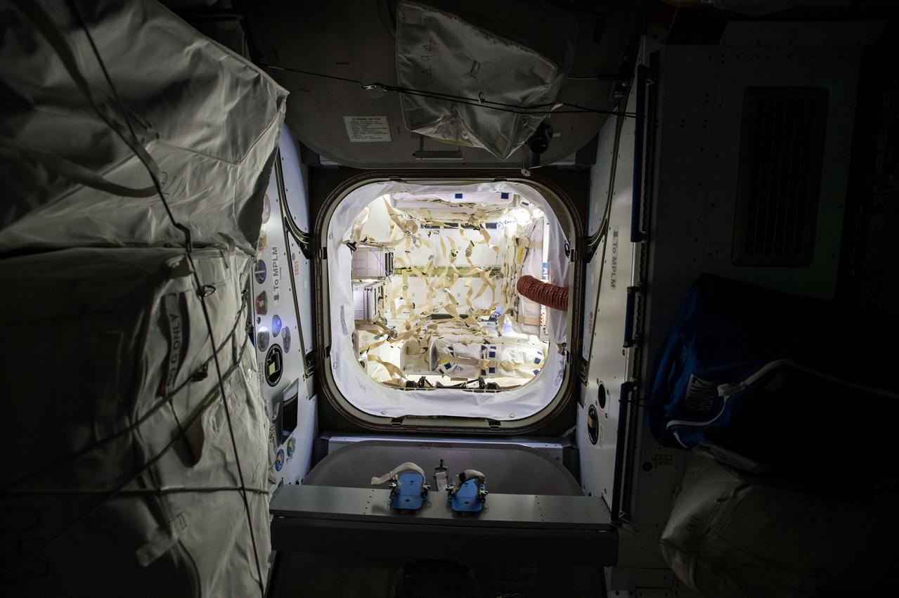
ISS042e136056 (Jan 13, 2015) -- Overall interior view of the SpaceX Dragon Commercial Resupply Services-5 (CRS-5) spacecraft.
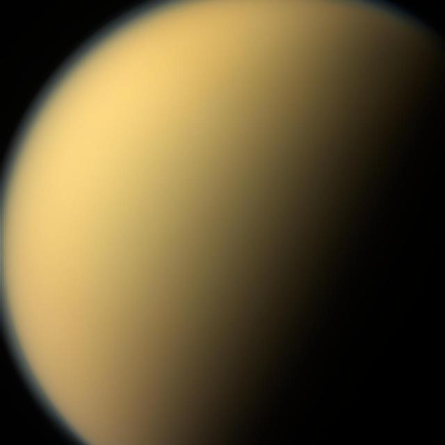
As it glanced around the Saturn system one final time, NASA's Cassini spacecraft captured this view of the planet's giant moon Titan. Interest in mysterious Titan was a major motivating factor to return to Saturn with Cassini-Huygens following the Voyager mission flybys of the early 1980s. Cassini and its Huygens probe, supplied by European Space Agency, revealed the moon to be every bit as fascinating as scientists had hoped. These views were obtained by Cassini's narrow-angle camera on Sept. 13, 2017. They are among the last images Cassini sent back to Earth. This natural color view, made from images taken using red, green and blue spectral filters, shows Titan much as Voyager saw it -- a mostly featureless golden orb, swathed in a dense atmospheric haze. An enhanced-color view (Figure 1) adds to this color a separate view taken using a spectral filter (centered at 938 nanometers) that can partially see through the haze. The views were acquired at a distance of 481,000 miles (774,000 kilometers) from Titan. The image scale is about 3 miles (5 kilometers) per pixel. https://photojournal.jpl.nasa.gov/catalog/PIA21890
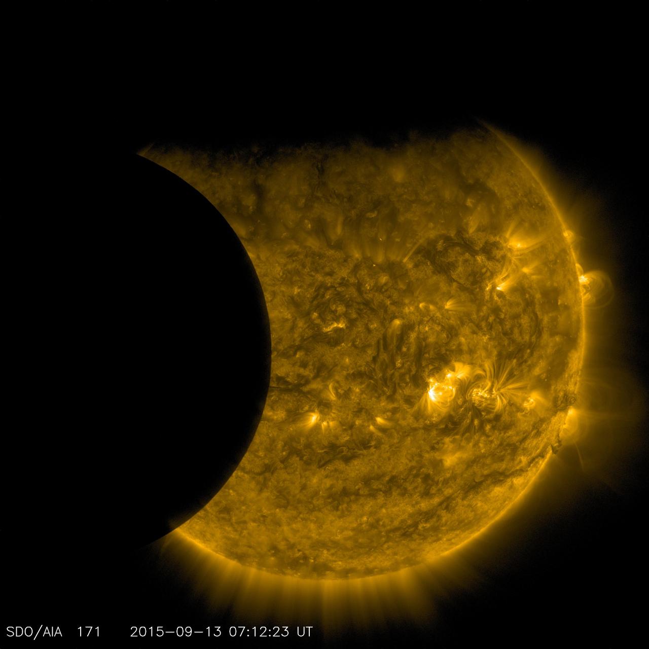
On Sept. 13, 2015, as NASA's Solar Dynamics Observatory, or SDO, kept up its constant watch on the sun, its view was photobombed not once, but twice. Just as the moon came into SDO's field of view on a path to cross the sun, Earth entered the picture, blocking SDO's view completely. When SDO's orbit finally emerged from behind Earth, the moon was just completing its journey across the sun's face. Though SDO sees dozens of Earth eclipses and several lunar transits each year, this is the first time ever that the two have coincided. SDO's orbit usually gives us unobstructed views of the sun, but Earth's revolution around the sun means that SDO's orbit passes behind Earth twice each year, for two to three weeks at a time. During these phases, Earth blocks SDO's view of the sun for anywhere from a few minutes to over an hour once each day. Earth's outline looks fuzzy, while the moon's is crystal-clear. This is because-while the planet itself completely blocks the sun's light-Earth's atmosphere is an incomplete barrier, blocking different amounts of light at different altitudes. However, the moon has no atmosphere, so during the transit we can see the crisp edges of the moon's horizon. http://photojournal.jpl.nasa.gov/catalog/PIA19949
View of the International Space Station (ISS) over a cloudy Earth following undocking at 1:13 p.m. (CST),December 9,2000 during the STS-97 flight.
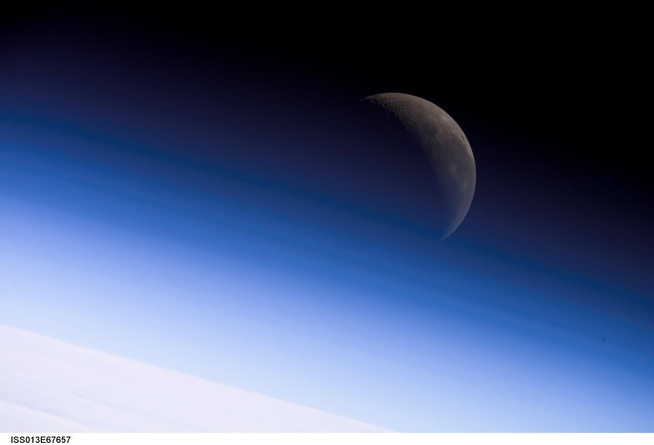
ISS013-E-67657 (18 Aug. 2006) --- A crescent moon is visible in this view of Earth's horizon and airglow, photographed by an Expedition 13 crewmember on the International Space Station.
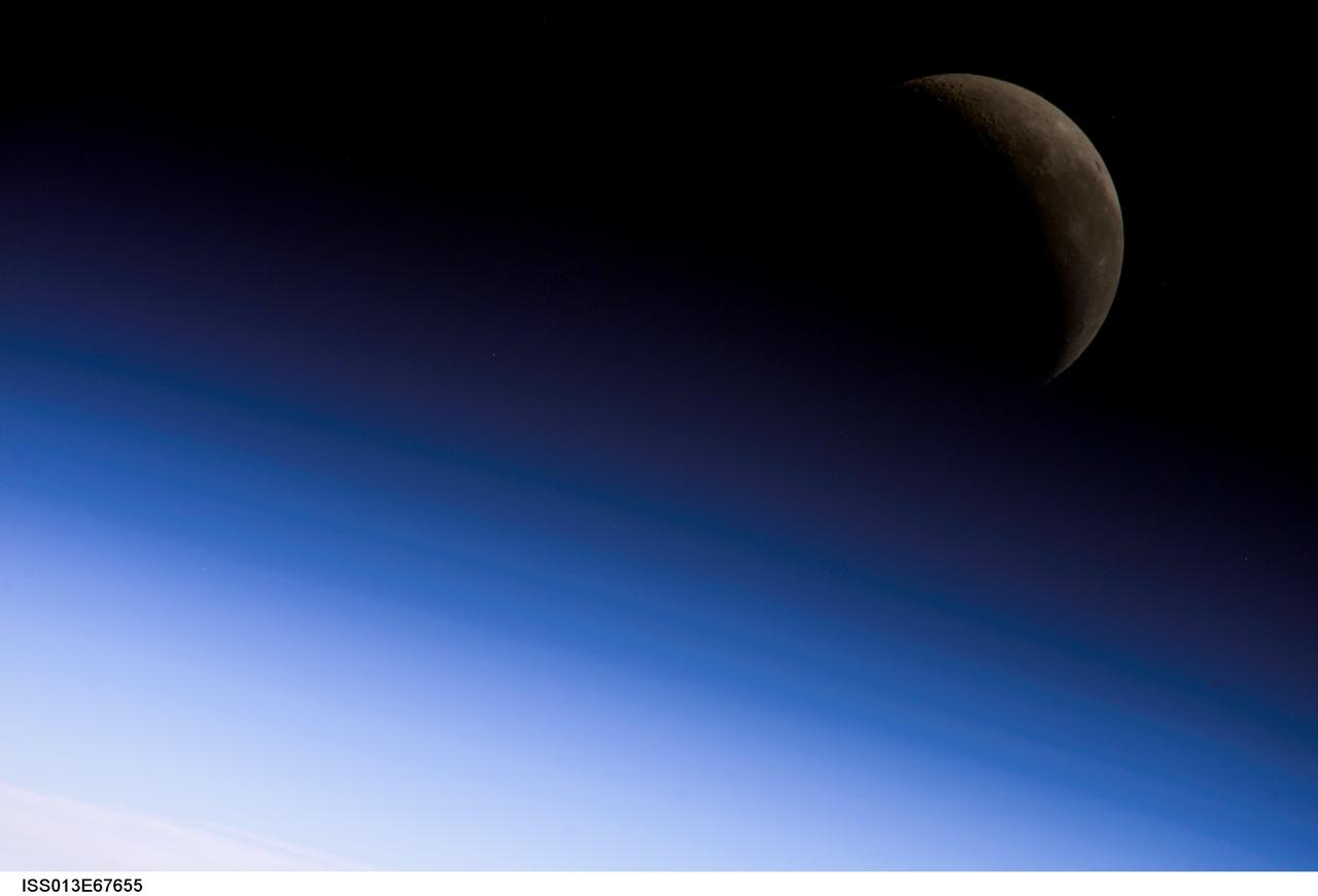
ISS013-E-67655 (18 Aug. 2006) --- A crescent moon is visible in this view of Earth's horizon and airglow, photographed by an Expedition 13 crewmember on the International Space Station.
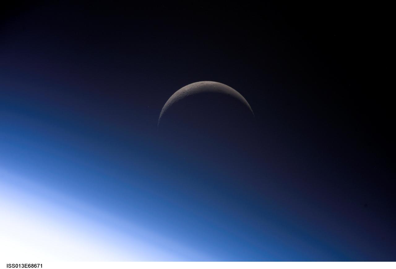
ISS013-E-68671 (18 Aug. 2006) --- A crescent moon is visible in this view of Earth's horizon and airglow, photographed by an Expedition 13 crewmember on the International Space Station.
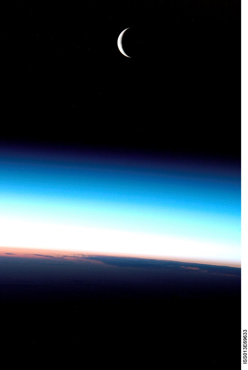
ISS013-E-69633 (August 2006) --- A crescent moon is visible in this view above Earth's horizon and airglow, photographed by an Expedition 13 crewmember on the International Space Station.
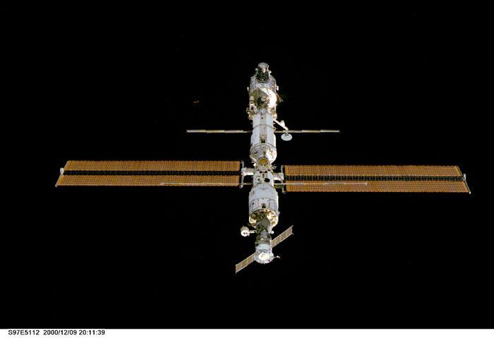
View of the International Space Station (ISS) following undocking at 1:13 p.m. (CST),December 9,2000 during the STS-97 flight.

Saturn's active, ocean-bearing moon Enceladus sinks behind the giant planet in a farewell portrait from NASA's Cassini spacecraft. This view of Enceladus was taken by NASA's Cassini spacecraft on Sept. 13, 2017. It is among the last images Cassini sent back. The view is part of a movie sequence of images taken over a period of 40 minutes as the icy moon passed behind Saturn from the spacecraft's point of view. Images taken using red, green and blue spectral filters were assembled to create the natural color view. (A monochrome version of the image, taken using a clear spectral filter, is also available.) The images were taken using Cassini's narrow-angle camera at a distance of 810,000 million miles (1.3 million kilometers) from Enceladus and about 620,000 miles (1 million kilometers) from Saturn. Image scale on Enceladus is 5 miles (8 kilometers) per pixel. A movie is available at https://photojournal.jpl.nasa.gov/catalog/PIA21889

With this view, Cassini captured one of its last looks at Saturn and its main rings from a distance. The Saturn system has been Cassini's home for 13 years, but that journey is nearing its end. Cassini has been orbiting Saturn for nearly a half of a Saturnian year but that journey is nearing its end. This extended stay has permitted observations of the long-term variability of the planet, moons, rings, and magnetosphere, observations not possible from short, fly-by style missions. When the spacecraft arrived at Saturn in 2004, the planet's northern hemisphere, seen here at top, was in darkness, just beginning to emerge from winter. Now at journey's end, the entire north pole is bathed in the continuous sunlight of summer. Images taken on Oct. 28, 2016 with the wide angle camera using red, green and blue spectral filters were combined to create this color view. This view looks toward the sunlit side of the rings from about 25 degrees above the ringplane. The view was acquired at a distance of approximately 870,000 miles (1.4 million kilometers) from Saturn. Image scale is 50 miles (80 kilometers) per pixel. https://photojournal.jpl.nasa.gov/catalog/PIA21345
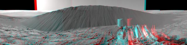
This stereo view from NASA's Curiosity Mars Rover shows the downwind side of "Namib Dune," which stands about 13 feet (4 meters) high. The image appears three-dimensional when viewed through red-blue glasses with the red lens on the left. The site is part of Bagnold Dunes, a band of dark sand dunes along the northwestern flank of Mars' Mount Sharp. The component images stitched together into this scene were taken with Curiosity's Navigation Camera (Navcam) on Dec. 17, 2015, during the 1,196th Martian day, or sol, of the rover's work on Mars. In late 2015 and early 2016, Curiosity is conducting the first up-close studies ever made of active sand dunes anywhere but on Earth. Under the influence of Martian wind, the Bagnold Dunes are migrating up to about one yard or meter per Earth year. http://photojournal.jpl.nasa.gov/catalog/PIA20282
S82-E-5140 (13 Feb. 1997) --- A back-lighted full view of the Hubble Space Telescope (HST) in the grasp of the Remote Manipulation System (RMS) following capture early today. The limb of Earth forms part of the background. This view was taken with an Electronic Still Camera (ESC).
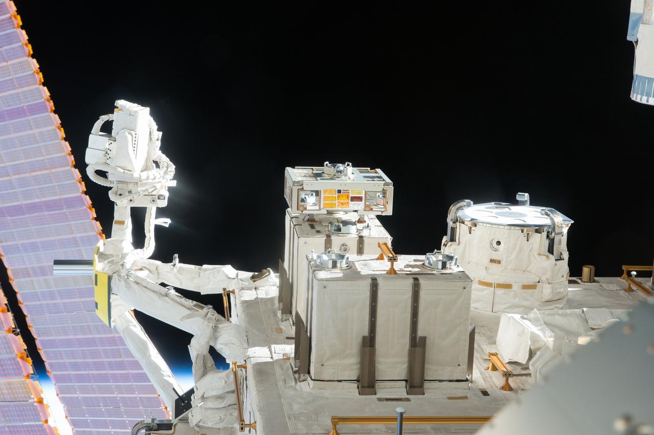
iss048e025920 (7/13/2016) --- View of the JEM (Japanese Experiment Module) Exposed Facility (JEF) taken through a window in the Kibo Japanese Experiment Pressurized Module (JPM). An Exposed Experiment Handrail Attachment Mechanism (ExHAM) and a Exposed Facility Unit (EFU) is in view.
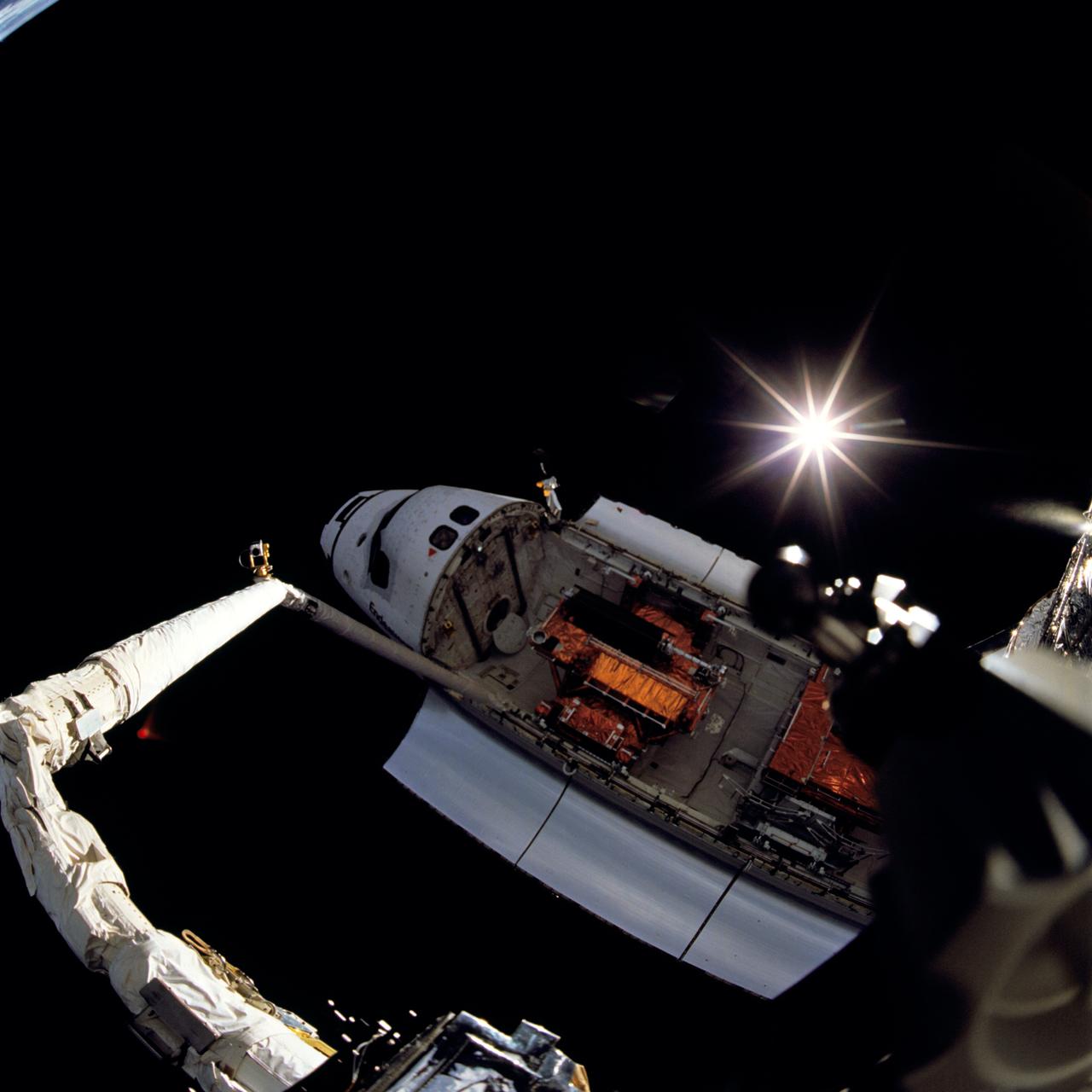
STS061-105-024 (2-13 Dec. 1993) --- One of Endeavour's space walkers captured this view of Endeavour backdropped against the blackness of space, with the Sun displaying a rayed effect. The extended Remote Manipulator System (RMS) arm that the astronaut was standing on is seen on the left side of the view.

This is a wide angle view of the martian north polar cap as it appeared to the Mars Global Surveyor (MGS) Mars Orbiter Camera (MOC) in early northern summer. The picture was acquired on March 13, 1999, near the start of the Mapping Phase of the MGS mission. The light-toned surfaces are residual water ice that remains through the summer season. The nearly circular band of dark material surrounding the cap consists mainly of sand dunes formed and shaped by wind. The north polar cap is roughly 1100 kilometers (680 miles) across. http://photojournal.jpl.nasa.gov/catalog/PIA02800
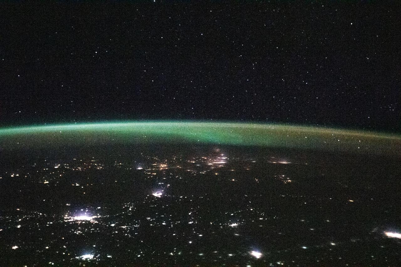
iss064e023203 (Jan. 13, 2021) --- This view from the International Space Station, as it orbited 264 miles above Kazakhstan, looks north towards Russia with its brightly lit cities blanketed by an aurora.
![jsc2022e057891 (5/13/2022) --- A view of two samples from the onboard camera to the mission control centre and personal computer screen [Credit: Space Applications Services, NV/SA]](https://images-assets.nasa.gov/image/jsc2022e057891/jsc2022e057891~medium.jpg)
jsc2022e057891 (5/13/2022) --- A view of two samples from the onboard camera to the mission control centre and personal computer screen [Credit: Space Applications Services, NV/SA]
S82-E-5175 (13 Feb. 1997) --- Hubble Space Telescope (HST) after capture berthed on Flight Support system (FSS) in Space Shuttle Discovery's payload bay. This view was taken with an Electronic Still Camera (ESC).
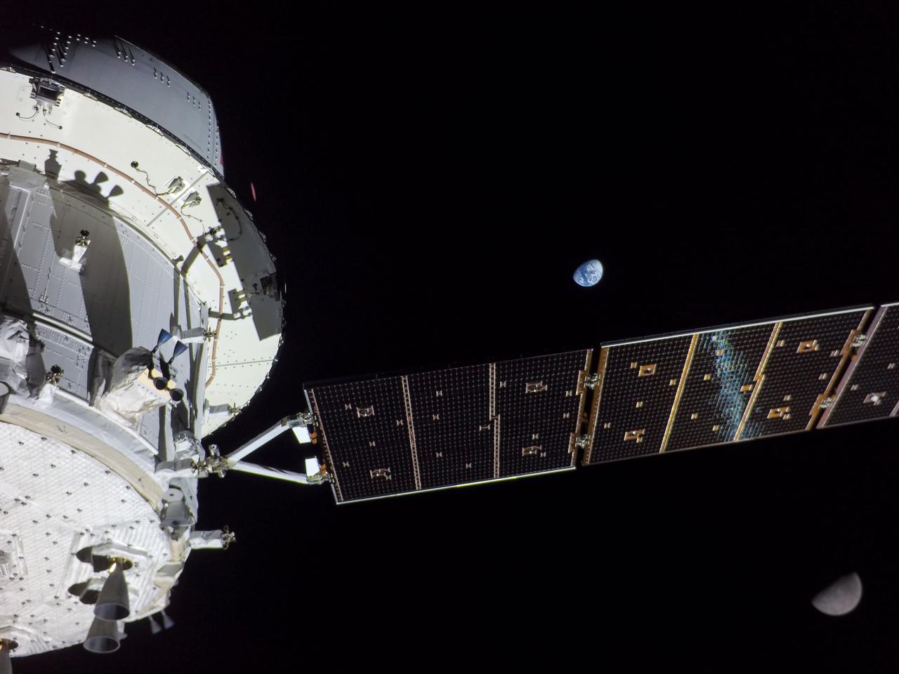
art001e001823 (Nov. 28, 2022) On flight day 13 of the Artemis I mission, Orion captured this view of Earth and the Moon on either sides of one of the spacecraft’s four solar arrays.
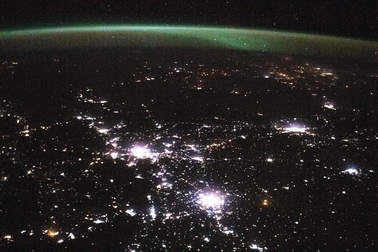
iss064e023201 (Jan. 13, 2021) --- This view from the International Space Station, as it orbited 264 miles above Kazakhstan, looks north towards Russia with its brightly lit cities blanketed by an aurora.

art001e001822 (Nov. 28, 2022) On flight day 13 of the Artemis I mission, Orion captured this view of Earth and the Moon on either sides of one of the spacecraft’s four solar arrays.
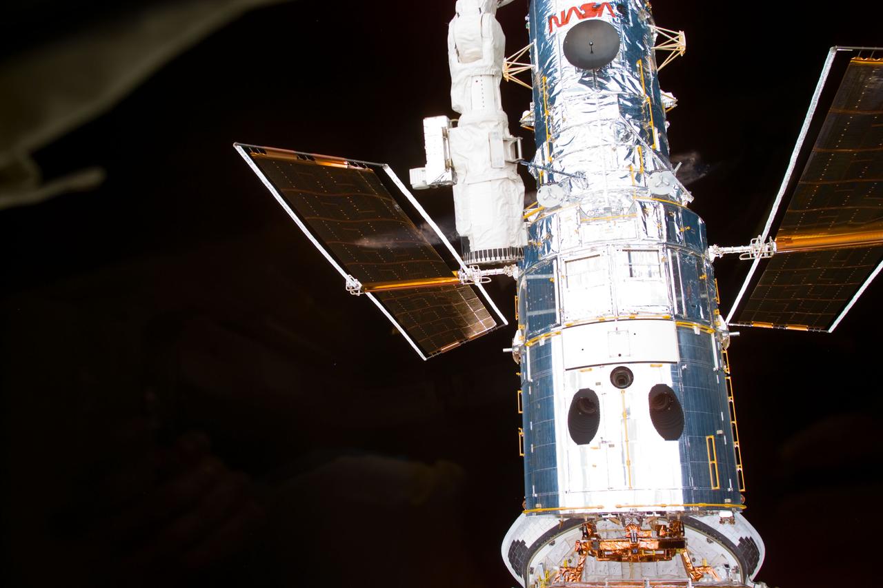
S82-E-5171 (13 Feb. 1997) --- Hubble Space Telescope (HST) after capture berthed on Flight Support system (FSS) in Space Shuttle Discovery's payload bay. This view was taken with an Electronic Still Camera (ESC).

STS102-E-5201 (13 March 2001) --- A view of the interior of the end effector apparatus on the end of the Canadian-built remote manipulator system (RMS) arm. The photograph was taken with a digital still camera.
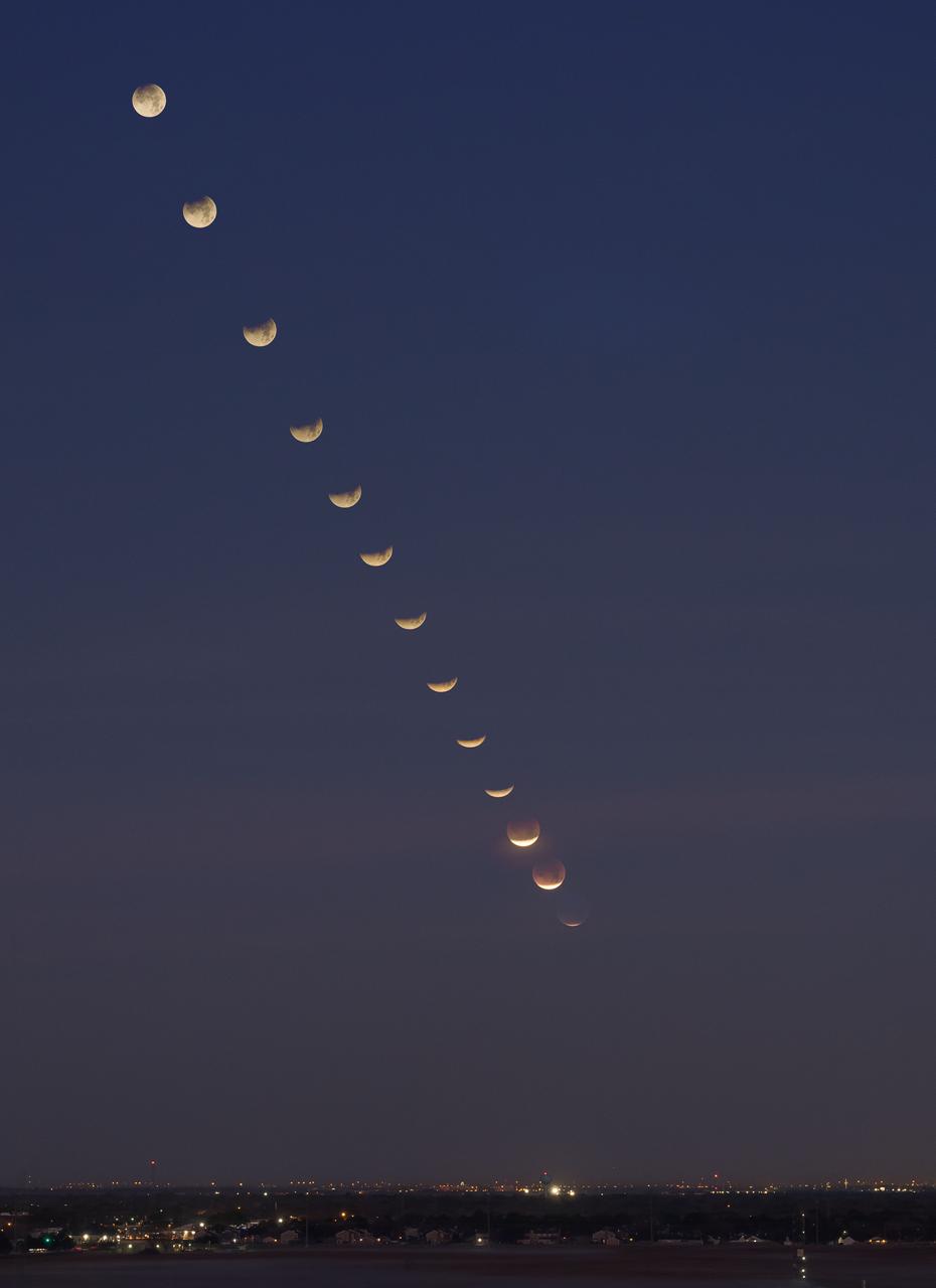
jsc2018e003235 (Jan. 31, 2018) --- Composite photograph created from 13 images of the lunar eclipse through its phases as viewed from the 9th floor of NASA Johnson Space Center’s Building 1.
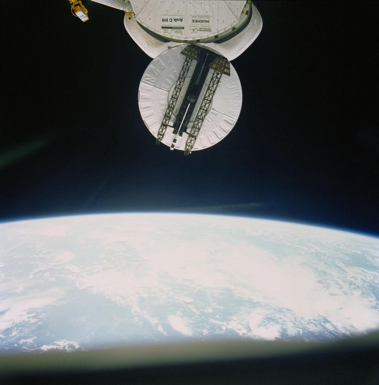
51D-31-081 (13 April 1985) --- 70mm view of the Syncom IV (LEASAT) communications satellite as it spins, frisbee fashion, from the cargo bay of the Earth orbiting Space Shuttle Discovery.
![jsc2022e057894 (5/13/2022) --- Views of the Maltese Biocube based on the ICE Cubes platform by Belgian company Space Applications Services [Credit: Space Applications Services, NV/SA]](https://images-assets.nasa.gov/image/jsc2022e057894/jsc2022e057894~medium.jpg)
jsc2022e057894 (5/13/2022) --- Views of the Maltese Biocube based on the ICE Cubes platform by Belgian company Space Applications Services [Credit: Space Applications Services, NV/SA]
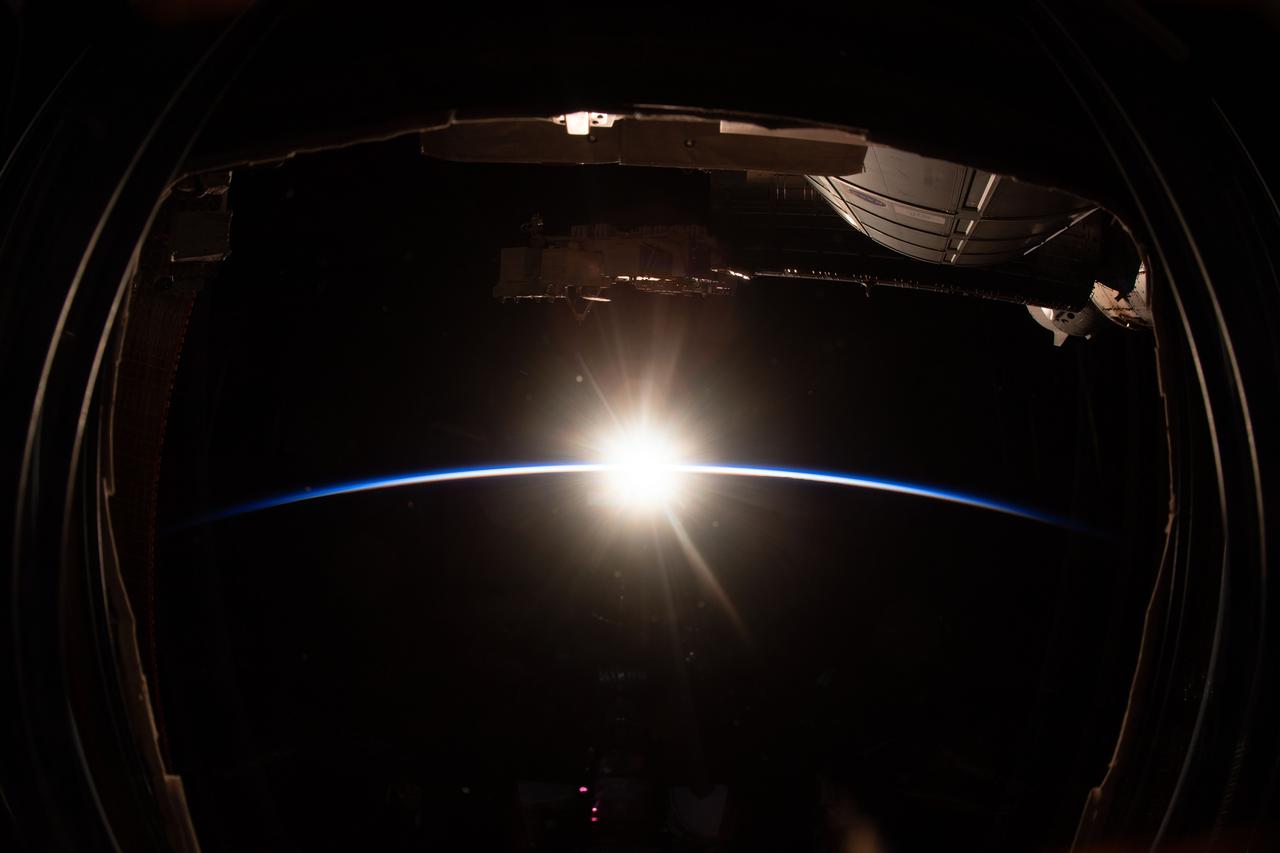
iss064e022835 (Jan. 13, 2021) --- This view from one of seven windows on the cupola shows an orbital sunrise as the International Space Station orbited 260 miles above the Pacific Ocean.
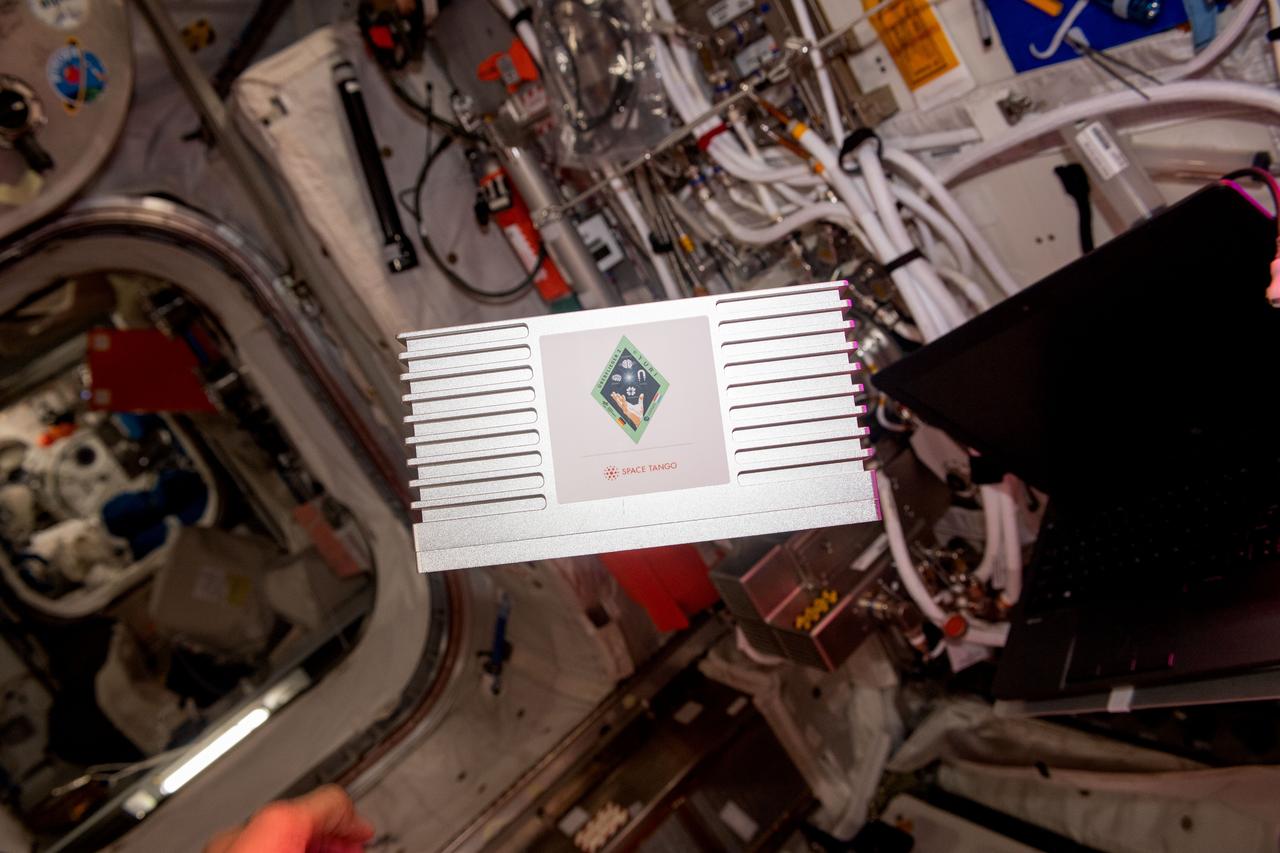
iss069e003201 (4/13/2023) --- A view of the Yuri investigation aboard the International Space Station (ISS). Yuri uses Space Tango CubeLab hardware to host four independent investigations developed by research teams in Germany and Luxembourg.
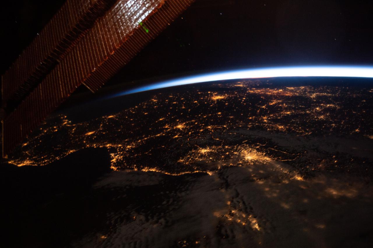
iss059e061476 (May 13, 2019) --- This oblique nighttime view of Western Europe and the well-lit coasts (from left) of Spain, France and Italy was taken from the International Space Station as it orbited 256 miles above the Mediterranean Sea.
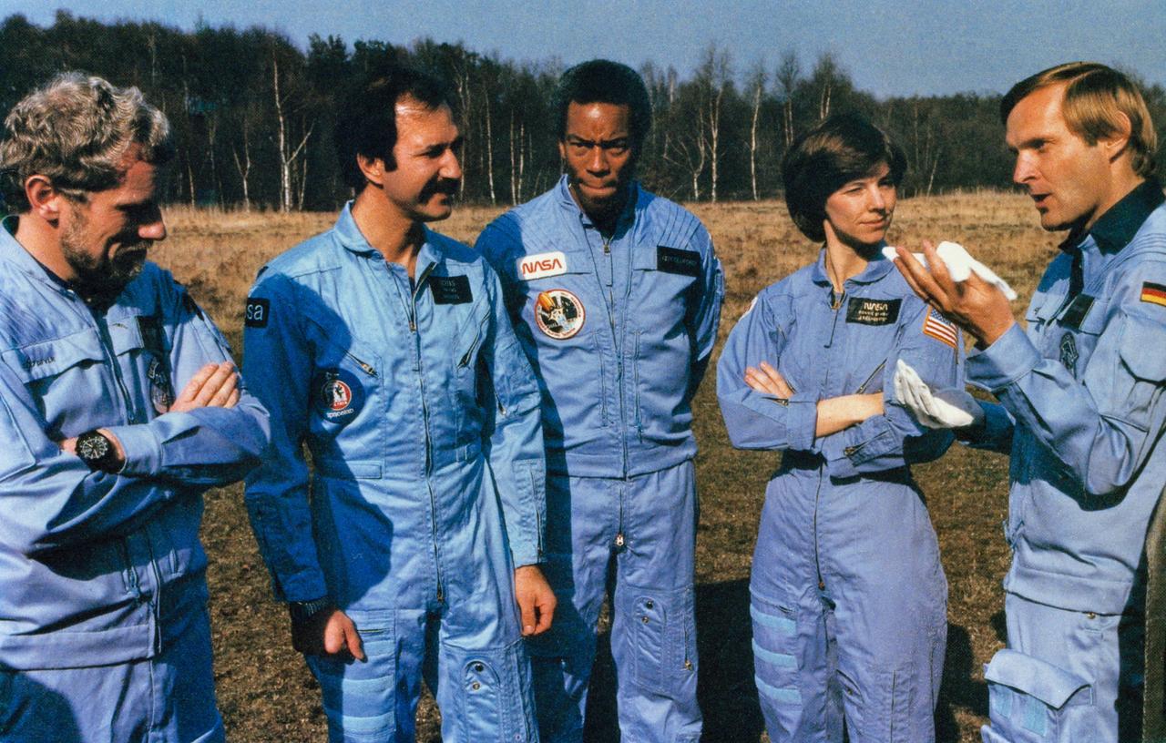
S84-47032 (13 Dec 1984) --- Candid view of part of the STS 61-A crew. From left to right are Reinhard Furrer, Wubbo Ockels, Guion S. Bluford, Bonnie J. Dunbar and Ernst Messerschmid.

ISS045E107821 (11/13/2015) --- As night falls the astronauts and cosmonauts aboard the International Space Station prepare for sleep while also viewing the softening curvature of the Earth go by with lighted cities below them and sparkling stars above.
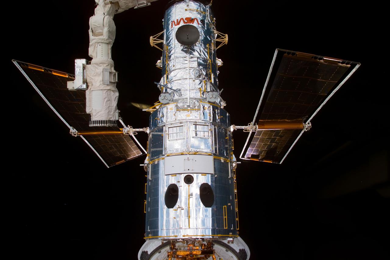
S82-E-5109 (13 Feb. 1997) --- A close-up survey view of Hubble Space Telescope (HST) recorded with the Electronic Still Camera (ESC) shows the high gain antenna.

An aerial view of NASA’s Kennedy Space Center and the surrounding Cape Canaveral, Fla. area is seen, Wednesday, May 13, 2026. Photo Credit: (NASA/John Kraus)

Four images from NASA's New Horizons' Long Range Reconnaissance Imager (LORRI) were combined with color data from the Ralph instrument to create this global view of Pluto. (The lower right edge of Pluto in this view currently lacks high-resolution color coverage.) The images, taken when the spacecraft was 280,000 miles (450,000 kilometers) away, show features as small as 1.4 miles (2.2 kilometers), twice the resolution of the single-image view taken on July 13. http://photojournal.jpl.nasa.gov/catalog/PIA19857
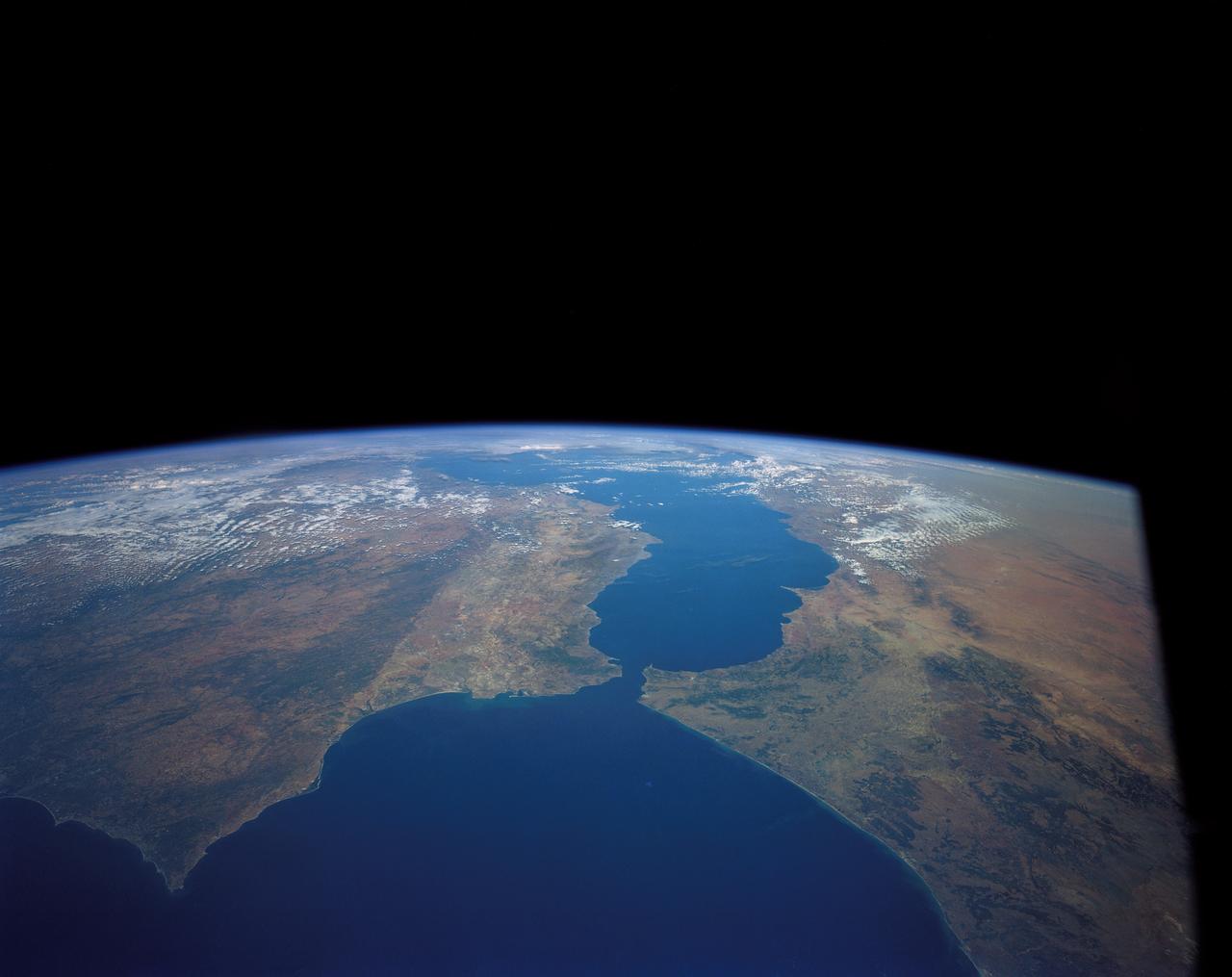
41G-120-082 (5-13 Oct. 1984) --- This High oblique view was photographed with a medium format camera aboard the Earth-orbiting space shuttle Challenger. It features the Strait of Gibraltar and the Mediterranean Sea. Unlike vertical photographs from this area taken by crews of previous spaceflights, this oblique view allows extensive viewing into Spain and Morocco. Photo credit: NASA
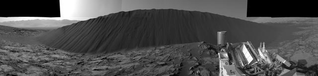
This view from NASA's Curiosity Mars Rover shows the downwind side of "Namib Dune," which stands about 13 feet (4 meters) high. The site is part of Bagnold Dunes, a band of dark sand dunes along the northwestern flank of Mars' Mount Sharp. The component images stitched together into this scene were taken with Curiosity's Navigation Camera (Navcam) on Dec. 17, 2015, during the 1,196th Martian day, or sol, of the rover's work on Mars. In late 2015 and early 2016, Curiosity is conducting the first up-close studies ever made of active sand dunes anywhere but on Earth. Under the influence of Martian wind, the Bagnold Dunes are migrating up to about one yard or meter per Earth year. The view spans from westward on the left to east-southeastward on the right. It is presented as a cylindrical perspective projection. http://photojournal.jpl.nasa.gov/catalog/PIA20281
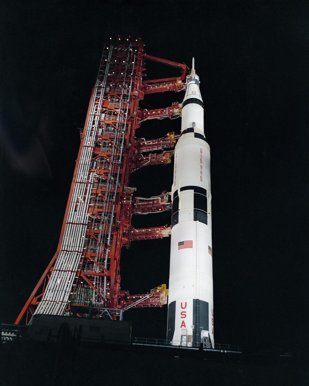
S70-32990 (24 March 1970) --- Nighttime, ground level view of Pad A, Launch Complex 39, Kennedy Space Center (KSC), showing the Apollo 13 (Spacecraft 109/Lunar Module 7/Saturn 508) space vehicle during Countdown Demonstration Test (CDDT). The crew of NASA's third lunar landing mission includes astronauts James A. Lovell Jr., commander; John L. Swigert Jr., command module pilot; and Fred W. Haise Jr., lunar module pilot. The Apollo 13 launch has been scheduled for 2:13 p.m. (EST), April 11, 1970.
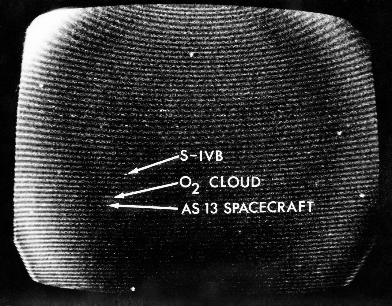
S70-34857 (13 April 1970) --- A telescopic photograph showing the Apollo 13 spacecraft in trans-lunar trajectory in the distant sky. Arrows point to the spacecraft, to the oxygen cloud, and to the expended Saturn V third stage. Apollo 13 was tracked at the Manned Spacecraft Center (MSC) using a 16 inch Schmidt-Cassegrain telescope with an IO television camera with an S-20 type IO tube, mounted in place of the eyepiece. The TV camera information is stored first on a data disc and played back on a viewing monitor from which this photograph was taken.
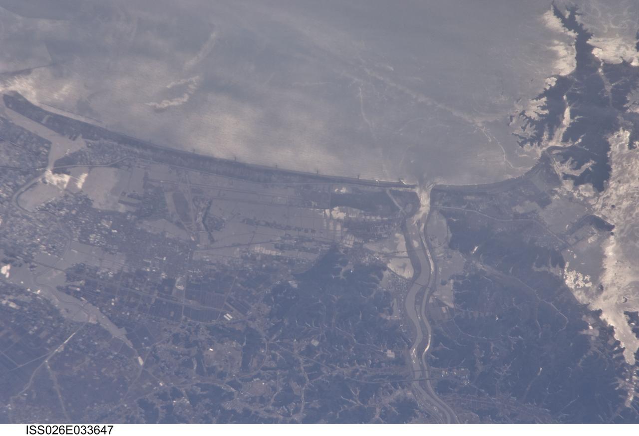
ISS026-E-033647 (13 March 2011 --- From 220 miles above Japan, an Expedition 26 crew member onboard the International Space Station took this 800mm view of the coast northeast of Sendai, between Matsushima Bay and the port of Ishinomake, on March 13. Sunglint helps to highlight the flood waters over the land, flowing out the rivers, plus oils swirling on the surface with the currents.

S85-E-5071 (13 August 1997) --- The STS-85 crew members aboard the Space Shuttle Discovery downlinked this oblique, Electronic Still Camera (ESC) view of the Super Typhoon Winnie about halfway between New Guinea and Japan in the Pacific Ocean late evening, August 13, 1997. Maximum sustained winds of 105 knots, gusts up to 130 knots. This photo was taken 14 1/2 hours after STS085-E-5069 was recorded with the same ESC.
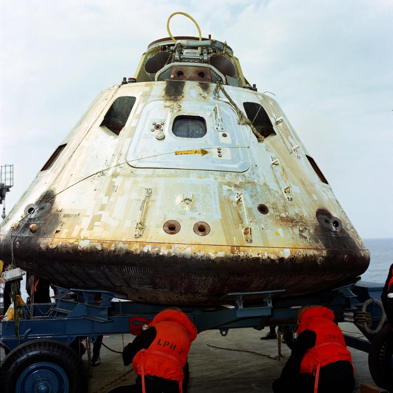
S69-20239 (13 March 1969) --- Close-up view of the Apollo 9 Command Module (CM) as it sets on dolly on the deck of the USS Guadalcanal just after being hoisted from the water. The Apollo 9 spacecraft, with astronauts James A. McDivitt, David R. Scott, and Russell L. Schweickart aboard, splashed down at 12:00:53 p.m. (EST), March 13, 1969, only 4.5 nautical miles from the aircraft carrier to conclude a successful 10-day Earth-orbital mission in space.
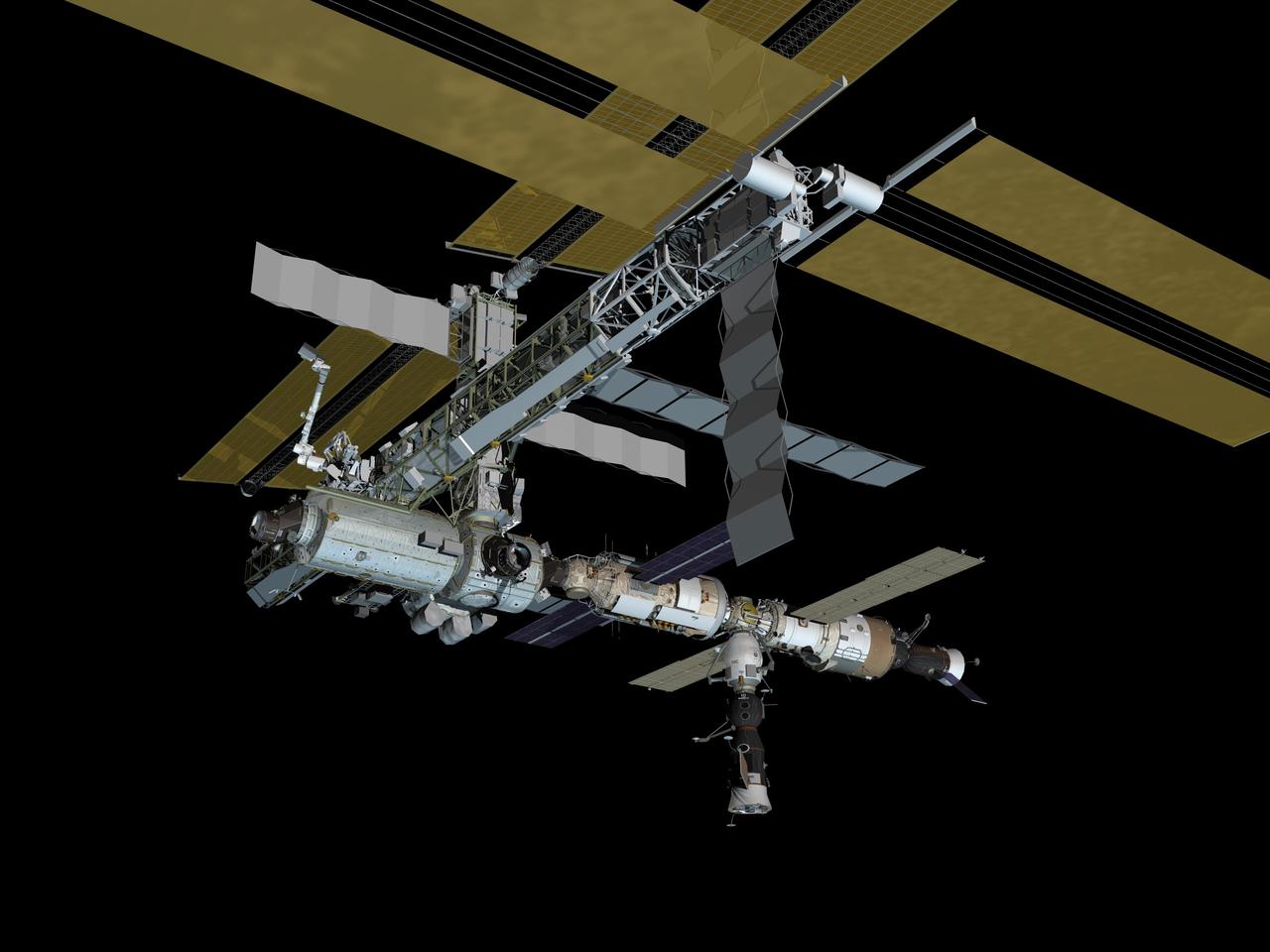
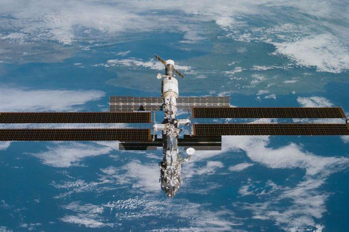
JSC2006-E-42992 (September 2006) --- Computer-generated artist's rendering of the International Space Station following scheduled activities of Sept. 29, 2006. This angle shows the port side view of the orbiting complex. Soyuz 12 (TMA-8) spacecraft undocks from the Zarya Module nadir port--returning the Expedition 13 crew and spaceflight participant to Earth. Soyuz 13 (TMA-9) is connected to the Zvezda Service Module aft port and Progress 22 resupply vehicle remains linked to the Pirs Docking Compartment.
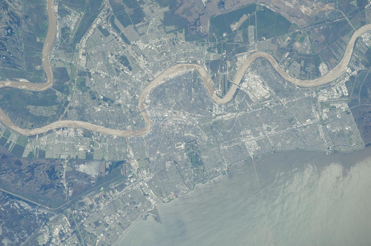
ISS039-E-001640 (13 March 2014) --- From an astronaut's point of view in Earth orbit, it would be difficult to miss the Mississippi River as it meanders through the city of New Orleans. Sunglint on Lake Pontchartrain is visible at lower right in the 400mm image, photographed by one of the Expedition 39 crew members aboard the International Space Station on March 13, 2014.
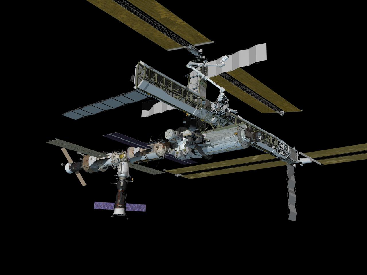
JSC2006-E-42993 (September 2006) --- Computer-generated artist's rendering of the International Space Station following scheduled activities of Sept. 29, 2006. This angle shows the starboard side view of the orbiting complex. Soyuz 12 (TMA-8) spacecraft undocks from the Zarya Module nadir port--returning the Expedition 13 crew and spaceflight participant to Earth. Soyuz 13 (TMA-9) is connected to the Zvezda Service Module aft port and Progress 22 resupply vehicle remains linked to the Pirs Docking Compartment.

jsc2017e114487 (Sept. 1, 2017) --- Expedition 53-54 crewmembers Mark Vande Hei (left) and Joe Acaba (right) of NASA take a moment to relish the view Sept. 1 as they toured the Kremlin in Moscow as part of traditional pre-launch ceremonies. Vande Hei, Acaba and Alexander Misurkin of Roscosmos will launch Sept. 13 from the Baikonur Cosmodrome in Kazakhstan Sept. 13 on the Soyuz MS-06 spacecraft for a five and a half month mission on the International Space Station. Credit: NASA/Elizabeth Weissinger
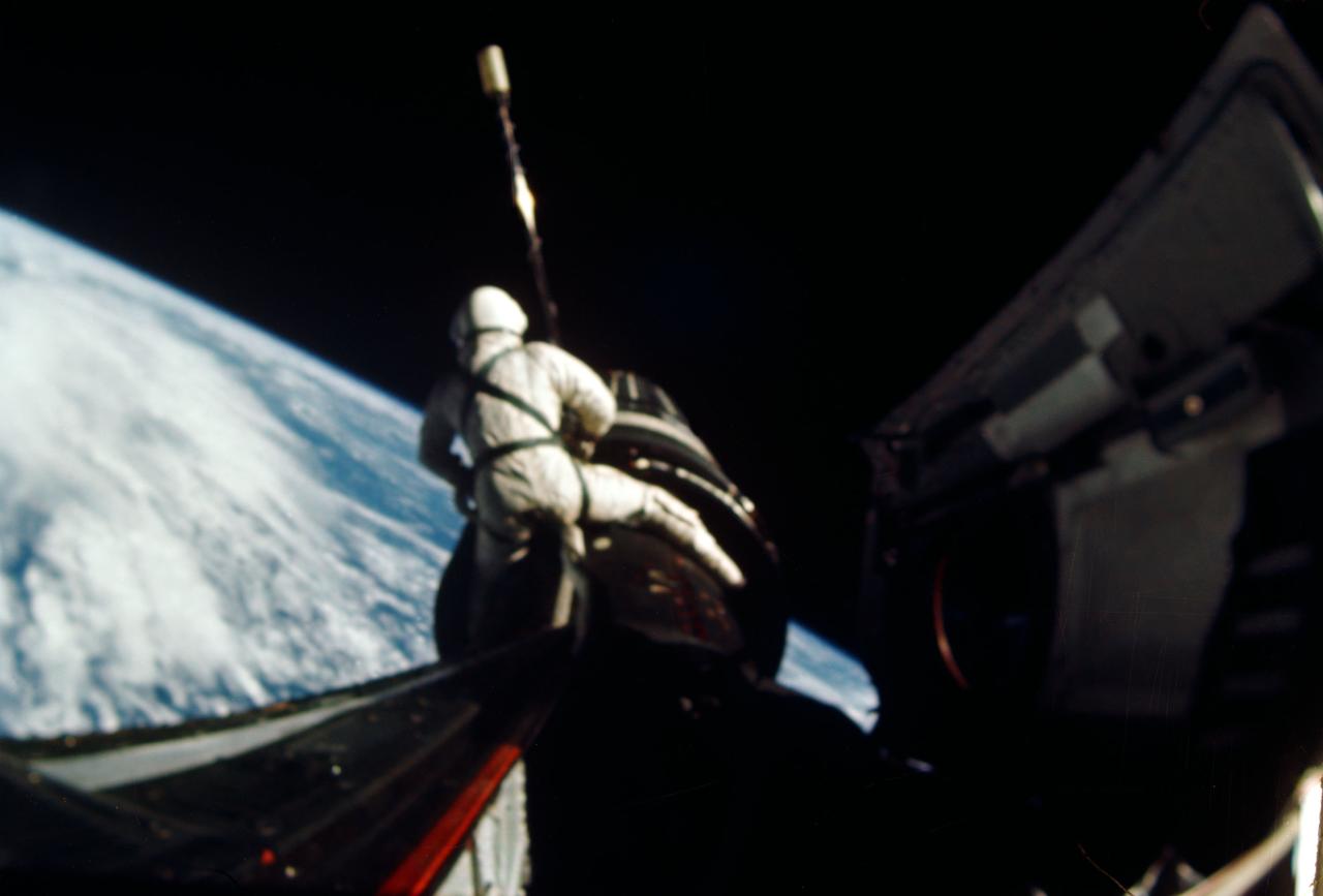
S66-54455 (13 Sept. 1966) --- Astronaut Richard F. Gordon Jr., Gemini-11 pilot, attaches a tether line from his spacecraft to the Agena Target Docking Vehicle (ATDV) during a spacewalk. This view was taken over the Atlantic Ocean at approximately 160 miles above Earth on Sept. 13, 1966. With the aid of the ATDV, Gordon and astronaut Charles (Pete) Conrad Jr., command pilot, set a new altitude record of 750 miles during the GT-11 mission. Photo credit: NASA
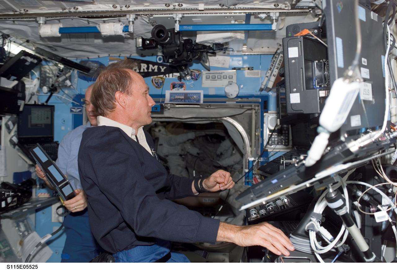
View of Astronauts Steve MacLean, Canadian Space Agency (CSA), Mission Specialist (MS), and Jeffrey N. Williams, Expedition 13 Flight Engineer (FE) and NASA Space Station Science Officer working at the Space Stations Robotic Arm to slowly move the 17 and a half ton P3/P4 truss to the port side of the Integrated Truss System. They will align it using a television camera and then mate it to the P1. Photo was taken in the U.S. Laboratory/Destiny during Expedition 13 / STS-115 joint operations.
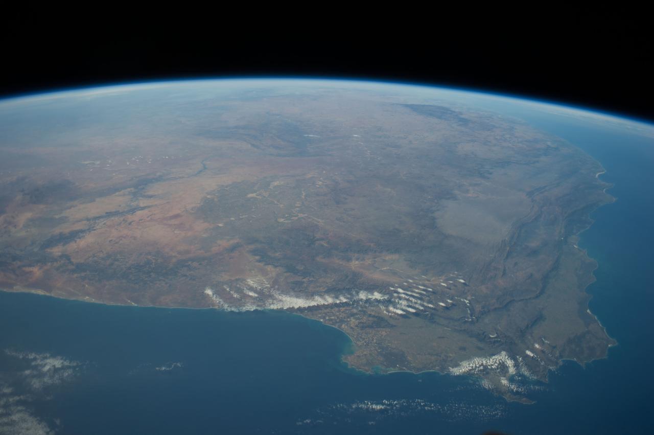
ISS040-E-011049 (13 June 2014) --- One of the Expedition 40 crew members aboard the International Space Station photographed this panoramic scene of South Africa and Lesotho on June 13. In the easterly-looking view, Capetown can easily be delineated near bottom center. The country of Lesotho -- one of only three nations in the world which are landlocked and totally surrounded by a single country -- is near the lava plateau at top right.