MOC View of Mars98 Landing Zone - 1/16/98
MOC View of Mars98 Landing Zone - 1/16/98
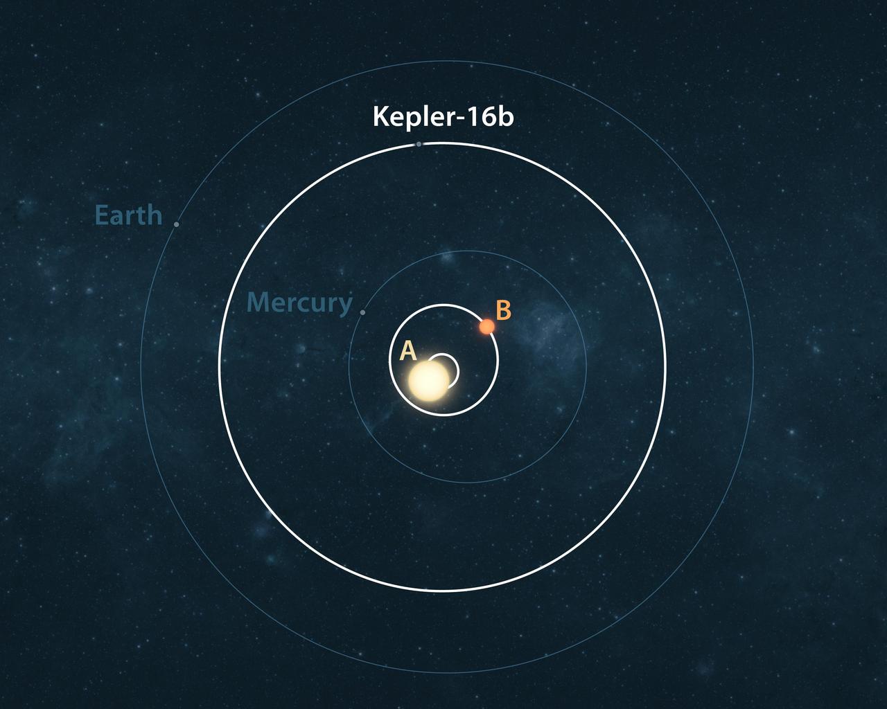
This artist conception illustrates the Kepler-16 system white from an overhead view, showing its planet Kepler-16b and the eccentric orbits of the two stars it circles labeled A and B.
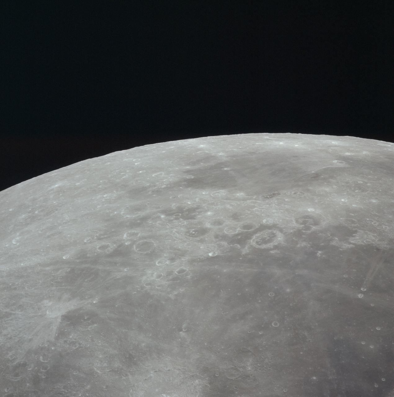
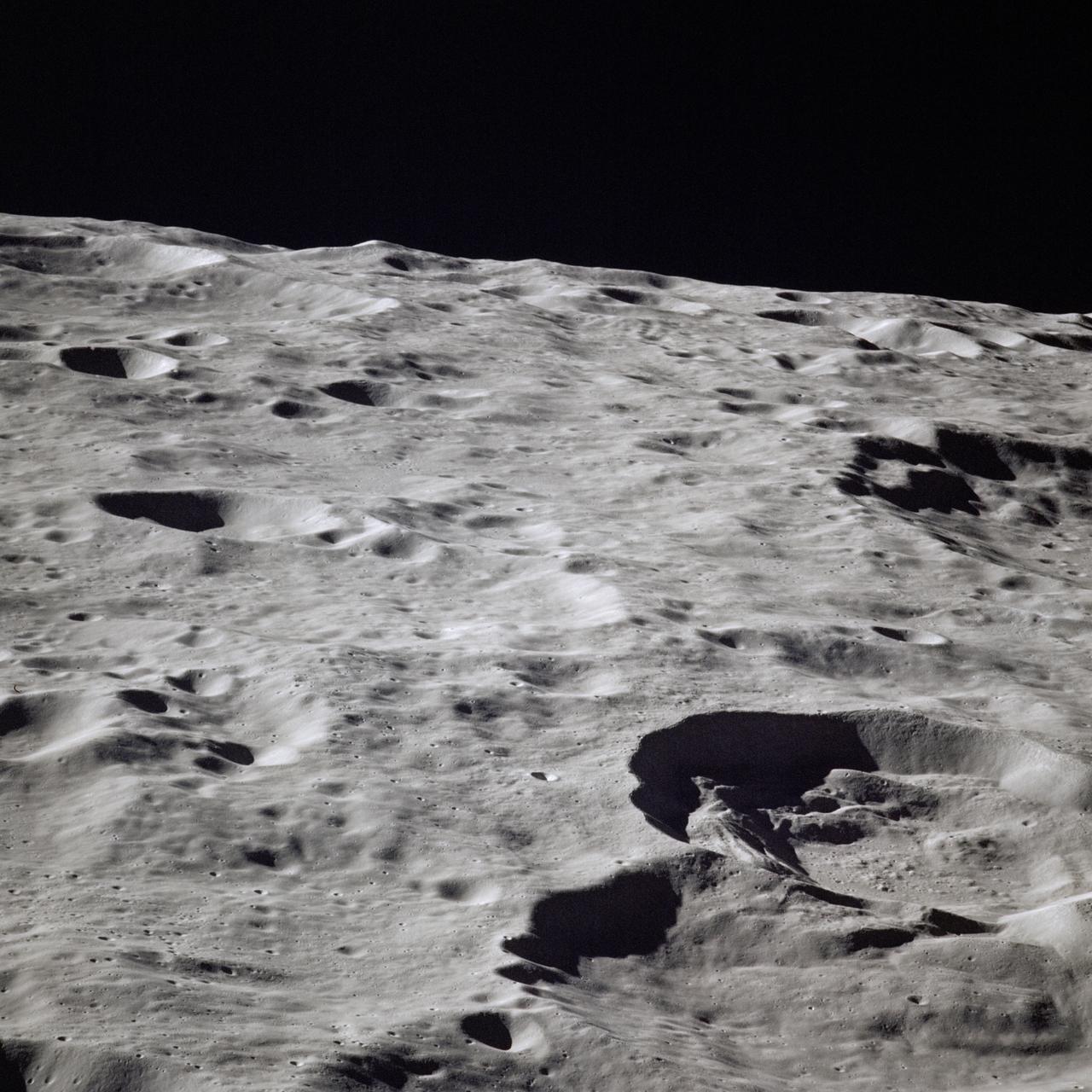
AS16-118-18964 (16-27 April 1972) --- This lunar farside oblique view from the Apollo 16 spacecraft in lunar orbit shows the Leonov Crater, just to the left and above the principal point of the photograph. Just beyond the horizon lies the Moscow Sea.
AS16-121-19449 (16-27 April 1972) --- This 70mm handheld camera's view of the moon, photographed during the Apollo 16 mission's trans-Earth coast, features Mare Fecunditatis (Sea of Fertility) in the foreground with the twin craters Messier at the lower right. Nearer the horizon is Mare Nectaris (Sea of Nectar) with craters Goclenius and Gutenberg in between. Goclenius is located at approximately 10 degrees south latitude and 45 degrees east longitude.
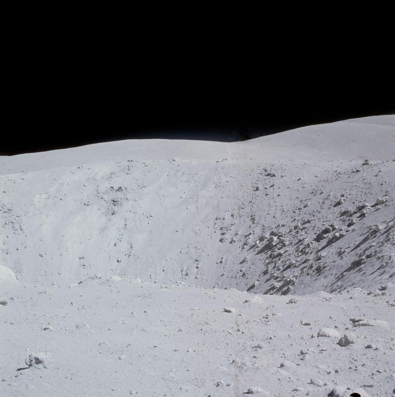
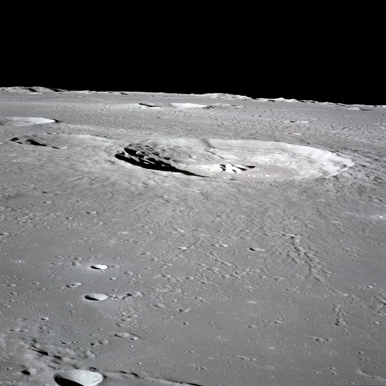
AS16-116-18599 (21 April 1972) --- A close-up view of Buster Crater, which was visited by the two moon-exploring crew men of the Apollo 16 lunar landing mission, during the first extravehicular activity (EVA), April 21, 1972. Astronaut Charles M. Duke Jr. said the crater appeared to be larger than 50 meters, and he called it a very spectacular crater. This was the second stop for astronauts John W. Young and Duke on the mission's first EVA. Young exposed this view with his 70mm Hasselblad camera. While astronauts Young, commander; and Duke, lunar module pilot; descended in the Apollo 16 Lunar Module (LM) "Orion" to explore the Descartes highlands landing site on the moon, astronaut Thomas K. Mattingly II, command module pilot, remained with the Command and Service Modules (CSM) "Casper" in lunar orbit.

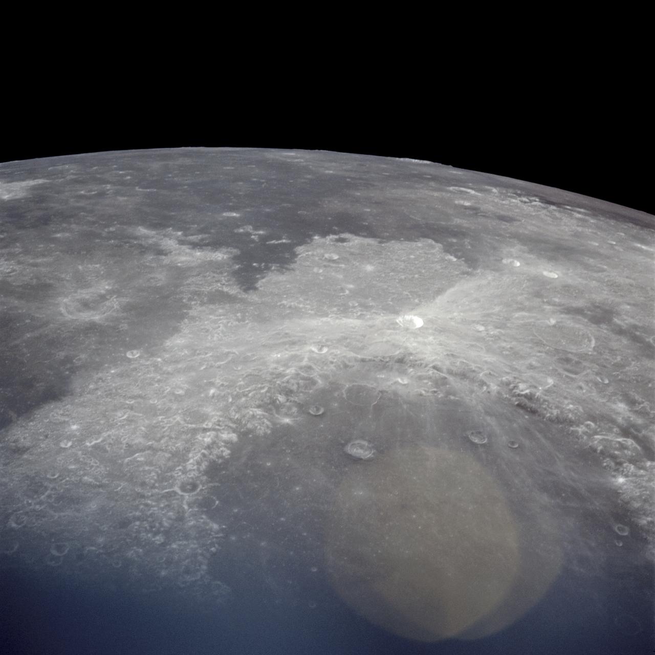
AS16-122-19592 (16-27 April 1972) --- An oblique view of the Border Sea area on the lunar nearside, as photographed from the Apollo 16 spacecraft in lunar orbit. Mare Marginus is at the left edge of the picture. This view is looking generally west by northwest. Goddard Crater is located at lower left. A portion of the Ibn Yunus Crater can be seen in the lower left corner adjoining the southeastern edge of Goddard. The Al-Biruni Crater is at lower right edge. The Hubble Crater is at right center edge.

GOES 12 satellite image showing earth on March 16, 2010 6:45 AM EDT. <b><a href="http://goes.gsfc.nasa.gov/" rel="nofollow">Credit: NOAA/NASA GOES Project</a><b> <b><a href="http://www.nasa.gov/centers/goddard/home/index.html" rel="nofollow">NASA Goddard Space Flight Center</a></b> is home to the nation's largest organization of combined scientists, engineers and technologists that build spacecraft, instruments and new technology to study the Earth, the sun, our solar system, and the universe. <b>Follow us on <a href="http://twitter.com/NASA_GoddardPix" rel="nofollow">Twitter</a></b> <b>Join us on <a href="http://www.facebook.com/pages/Greenbelt-MD/NASA-Goddard/395013845897?ref=tsd" rel="nofollow">Facebook</a></b></b></b>
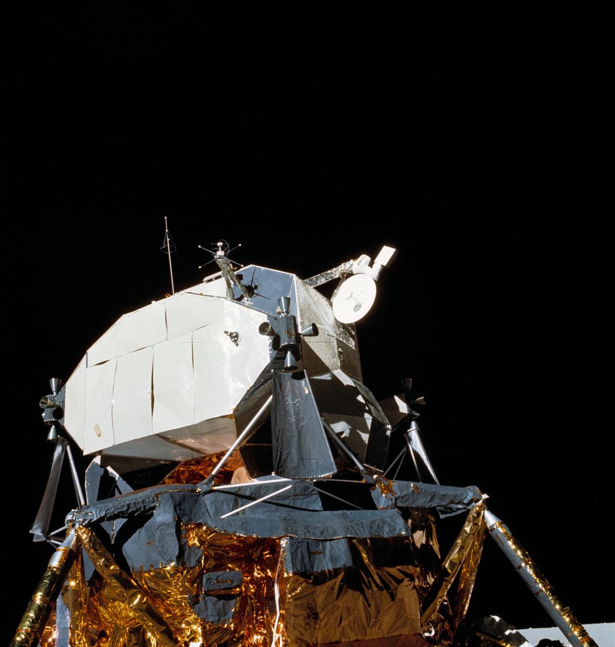
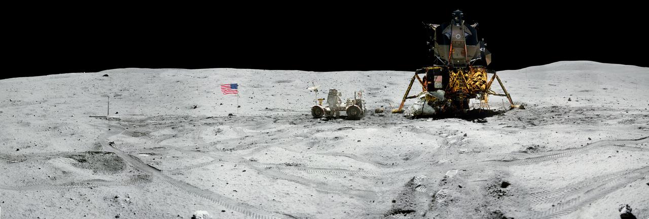
AS16-113-18334 (21 April 1972) --- View of the Lunar Module (LM) "Orion" parked on the lunar surface. During their post mission press conference, the Apollo 16 crewmembers called attention to the steerable S-band antenna, which was "frozen" in a yaw axis during much of the flight. This view of the LM was photographed by astronaut Charles M. Duke Jr., the lunar module pilot, during the mission's first extravehicular activity (EVA). Astronauts John W. Young, commander, and Duke had earlier descended in the LM to explore the Descartes region of the moon, while astronaut Thomas K. Mattingly II, command module pilot, remained with the Command and Service Modules (CSM) "Casper" in lunar orbit.
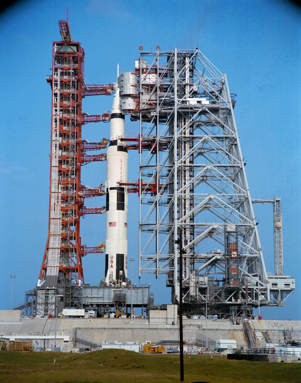
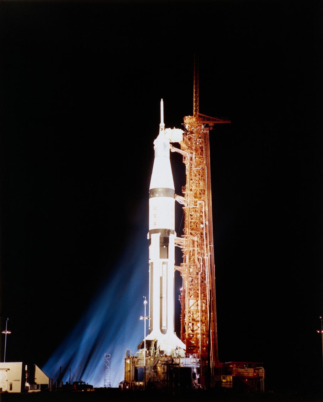
S72-34473 (29 March 1972) --- A ground-level view of Pad A, Launch Complex 39, Kennedy Space Center (KSC), showing the 363-feet tall Apollo 16 (Spacecraft 113/Lunar Module 11/Saturn 511) space vehicle during a Countdown Demonstration Test (CDDT). The CDDT was part of the preflight preparations for the Apollo 16 lunar landing mission. The crew of Apollo 16, scheduled for launch on April 16, 1972, are astronauts John W. Young, commander; Thomas K. (Ken) Mattingly II, command module pilot; and Charles M. Duke Jr., lunar module pilot.
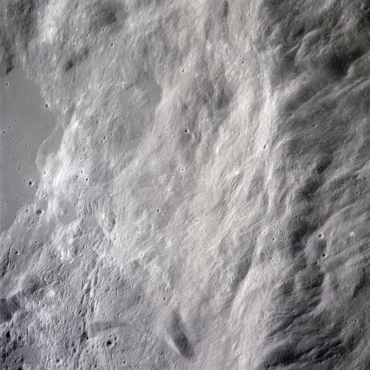
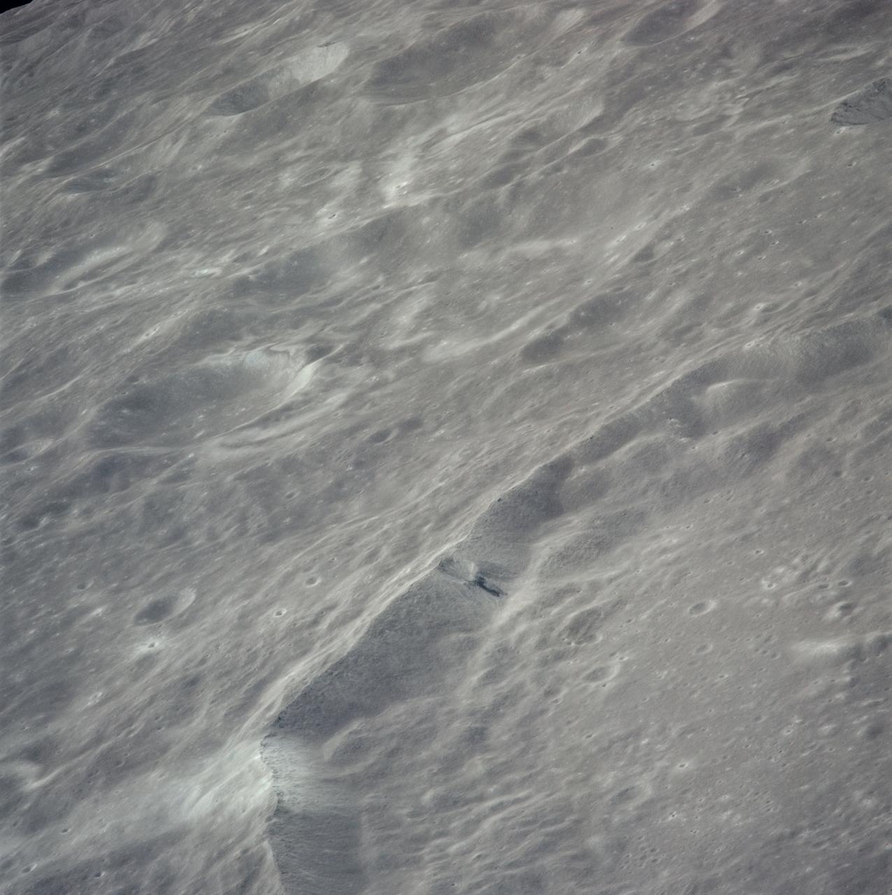
AS16-120-19228 (16-27 April 1972) --- Strongly textured terrain north of the lunar farside King Crater which is centered near 120.5 degrees east longitude and 5.5 degrees north latitude. This near vertical oblique view eastward was photographed from the Apollo 16 spacecraft in lunar orbit with a Hasselblad camera equipped with a 250mm telephoto lens. Several irregular areas characterized by conspicuously smooth surfaces interrupt the rough texture in this view of the eastern quarter of the large, unnamed crater between King and Guyot. Similar "ponds" occur at varied levels in the rim deposits of the nearside craters Copernicus and Tycho. Hold picture with the smooth area at the top.
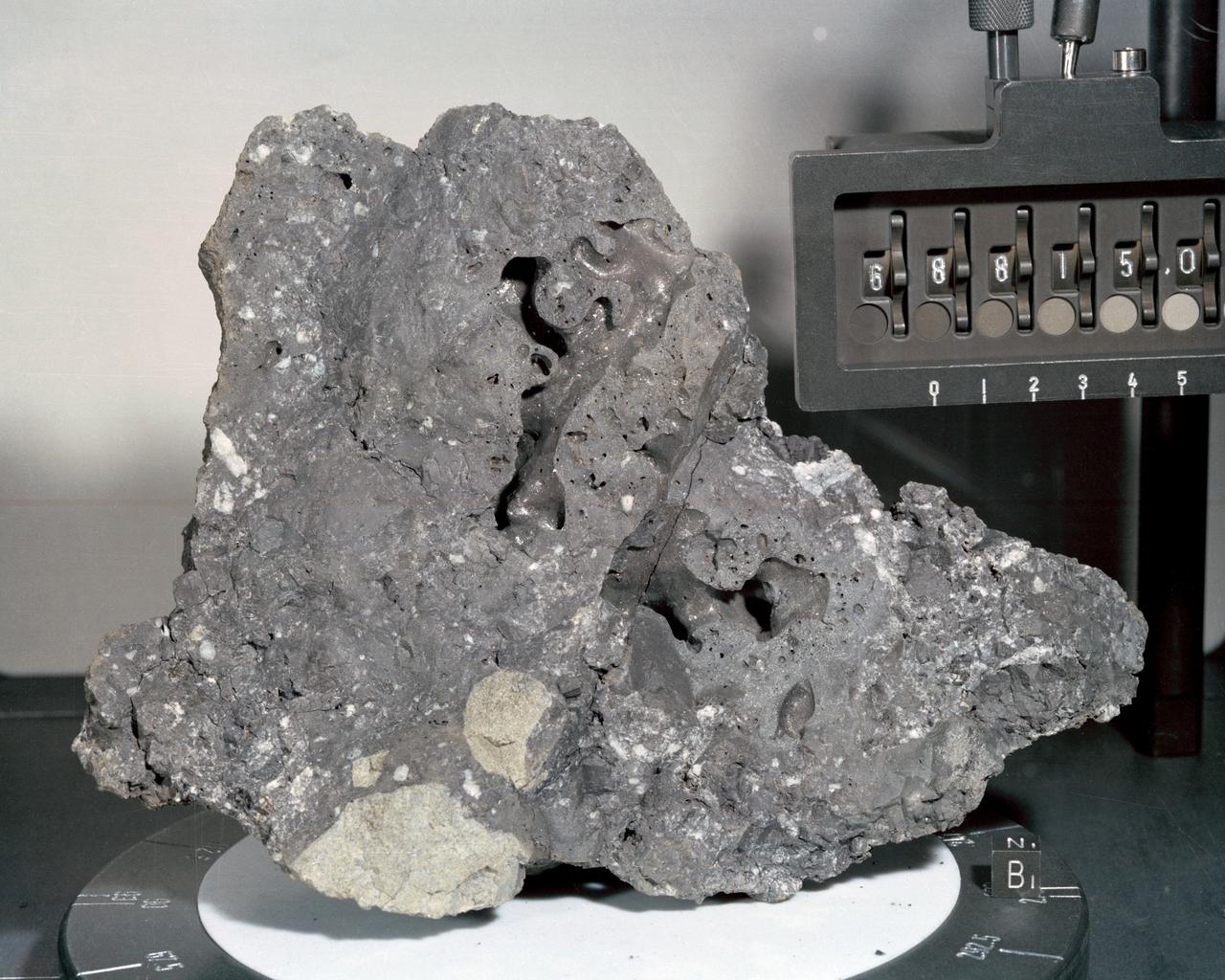
A closeup view or "mug shot" of Apollo 16 lunar sample no. 68815, a dislodged fragment from a parent boulder roughly four feet high and five feet long encountered at Station 8. The crew tried in vain to overturn the parent boulder. A fillet-soil sample was taken close to the boulder, allowing for study of the type and rate of erosion acting on lunar rocks. The fragment itself is very hard, has many veticles and a variety of inclusions. In addition, numerous metallic particles were observed in the black matrix.
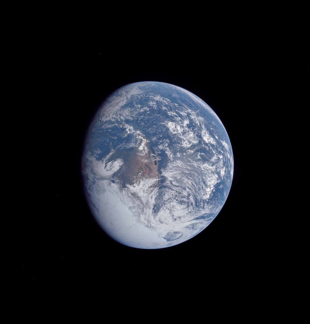
AS16-118-18885 (16 April 1972) --- A good view of Earth photographed about one and one-half hours after trans-lunar injection on April 16, 1972. Although there is much cloud cover, the United States in large part, most of Mexico and some parts of Central America are clearly visible. Note Lake Michigan and Lake Superior and the Bahama Banks (see different shade of blue below Florida). Just beginning man's fifth lunar landing mission were astronauts John W. Young, commander; Thomas K. Mattingly, II, command module pilot and Charles M. Duke Jr., lunar module pilot. While astronauts Young and Duke descended in the Lunar Module (LM) "Orion" to explore the Descartes highlands region of the moon, astronaut Mattingly remained with the Command and Service Modules (CSM) "Casper" in lunar orbit.

AS16-118-18880 (16 April 1972) --- A good view of Earth photographed about one hour after trans-lunar injection on April 16, 1972. Although there is much cloud cover, the United States in large part, most of Mexico and some of Central America are clearly visible. Note the Great Lakes (Michigan and Superior) and the Bahama Banks (note different shade of blue below Florida). While astronauts John W. Young, commander, and Charles M. Duke Jr., lunar module pilot, descended in the Lunar Module (LM) "Orion" to explore the Descartes highlands region of the moon, astronaut Thomas K. (Ken) Mattingly II, command module pilot, remained with the Command and Service Modules (CSM) "Casper" in lunar orbit.
AS16-118-18873 (16 April 1972) --- A good view of Earth photographed shortly after trans-lunar injection of April 16, 1972. Although there is much cloud cover (over Canada and the oceans), the United States in large part, most of Mexico and some parts of Central America are clearly visible. Note Lake Michigan and Lake Superior, also note the Bahama Banks at upper right part of the sphere. A large part of the Rocky Mountain Range is also visible. Just beginning man's fifth lunar landing mission were astronauts John W. Young, commander; Thomas K. Mattingly II, command module pilot; and Charles M. Duke Jr., lunar module pilot. While astronauts Young and Duke descended in the Lunar Module (LM) to explore the moon, astronaut Mattingly remained with the Command and Service Modules (CSM) in lunar orbit.
AS16-118-18947 (16-27 April 1972) --- A 250mm view looking north by westward across lunar farside highland terrain, as photographed from the Apollo 16 spacecraft in lunar orbit. The frame is centered at approximately 158 degrees east longitude and 17 degrees north latitude. Van Gent Crater is the lower of two large craters at extreme lower right corner. The top of the two craters is unnamed. The west part of Konstantinov Crater is at extreme right center. Nagaoka Crater is just below the horizon at upper left.
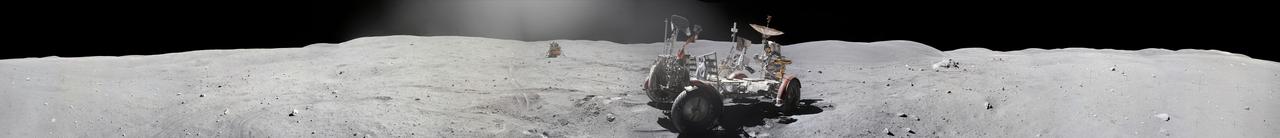
The second manned lunar landing mission, Apollo 12, launched from launch pad 39-A at Kennedy Space Center in Florida on November 14, 1969 via a Saturn V launch vehicle. The Saturn V vehicle was developed by the Marshall Space Flight Center (MSFC) under the direction of Dr. Wernher von Braun. Aboard Apollo 12 was a crew of three astronauts: Alan L. Bean, pilot of the Lunar Module (LM), Intrepid; Richard Gordon, pilot of the Command Module (CM), Yankee Clipper; and Spacecraft Commander Charles Conrad. The LM, Intrepid, landed astronauts Conrad and Bean on the lunar surface in what’s known as the Ocean of Storms while astronaut Richard Gordon piloted the CM, Yankee Clipper, in a parking orbit around the Moon. Lunar soil activities included the deployment of the Apollo Lunar Surface Experiments Package (ALSEP), finding the unmanned Surveyor 3 that landed on the Moon on April 19, 1967, and collecting 75 pounds (34 kilograms) of rock samples. This is the sixteenth of 25 images captured by the crew in attempt to provide a 360 degree Lunar surface scene. Apollo 12 safely returned to Earth on November 24, 1969.
AS16-121-19407 (April 1972) --- An oblique view of a rim of Guyot Crater on the lunar farside, as photographed from the Apollo 16 spacecraft in lunar orbit. The coordinates of the center of Guyot Crater are 116.5 degrees east longitude and 10.5 degrees north latitude. Note the black coloration which appears to be lava flow down the side of the crater rim. While astronauts John W. Young, commander; and Charles M. Duke Jr., lunar module pilot; descended in the Apollo 16 Lunar Module (LM) "Orion" to explore the Descartes highlands site on the moon, astronaut Thomas K. Mattingly II, command module pilot, remained with the Command and Service Modules (CSM) "Casper" in lunar orbit.
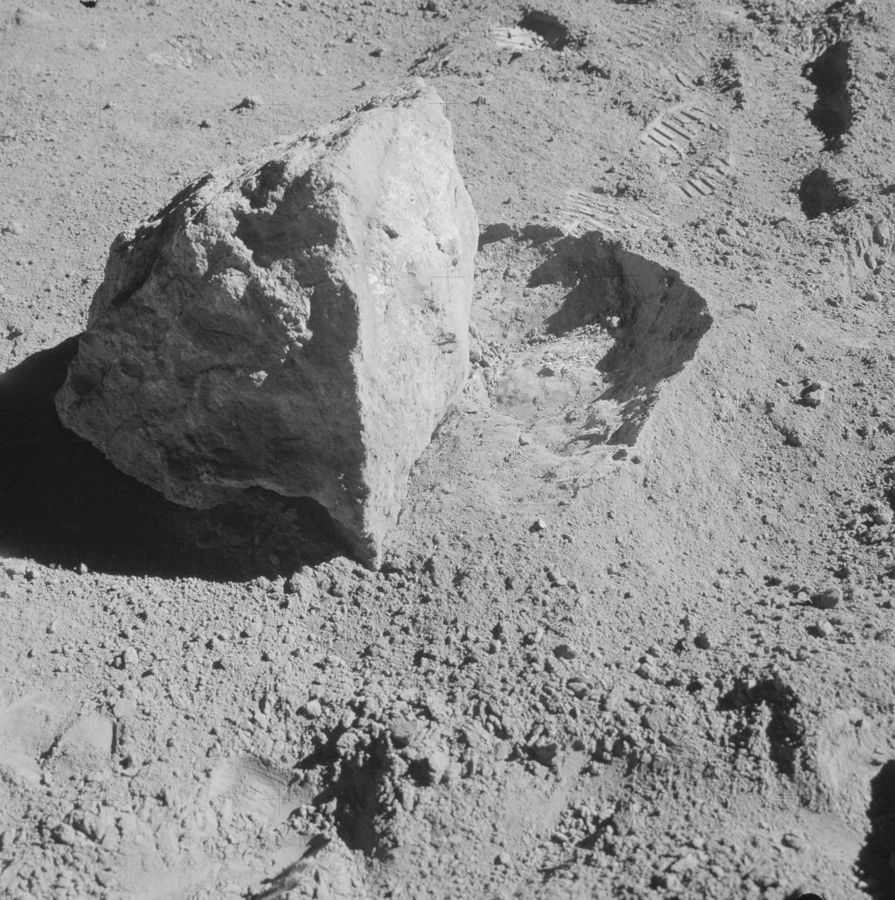
AS16-107-17573 (22 April 1972) --- A close-up view of a block (about 1/2 meter long) found by the two moon-exploring crewmembers of the Apollo 16 lunar landing mission. The block had been rolled over only moments earlier during this Apollo 16 second extravehicular activity (EVA) near South Ray Crater. Astronaut John W. Young, commander, said at the post-mission press conference, "The block has been sitting there evidently since South Ray Crater was formed." While astronauts Young and Charles M. Duke Jr., lunar module pilot; descended in the Apollo 16 Lunar Module (LM) "Orion" to explore the Descartes highlands landing site on the moon, astronaut Thomas K. Mattingly II, command module pilot, remained with the Command and Service Modules (CSM) "Casper" in lunar orbit.
AS16-120-19242 (16-27 April 1972) --- This 70mm handheld camera's view of the moon, photographed during the Apollo 16 mission's lunar orbit, features Crater Bullialdus, located at approximately 20 degrees south latitude and 20.8 west longitude.
AS16-121-19438 (April 1972) --- An oblique view of a portion of the lunar nearside as photographed from the Apollo 16 spacecraft in lunar orbit, looking across the Sea of Crises southwesterly into the Sea of Tranquility. The conspicuous, bright-rayed crater is Proclus. The crater Taruntius in the northeasterly portion of the Sea of Fertility is near the left center edge. A portion of the Sea of Serenity is visible on the horizon at upper right.
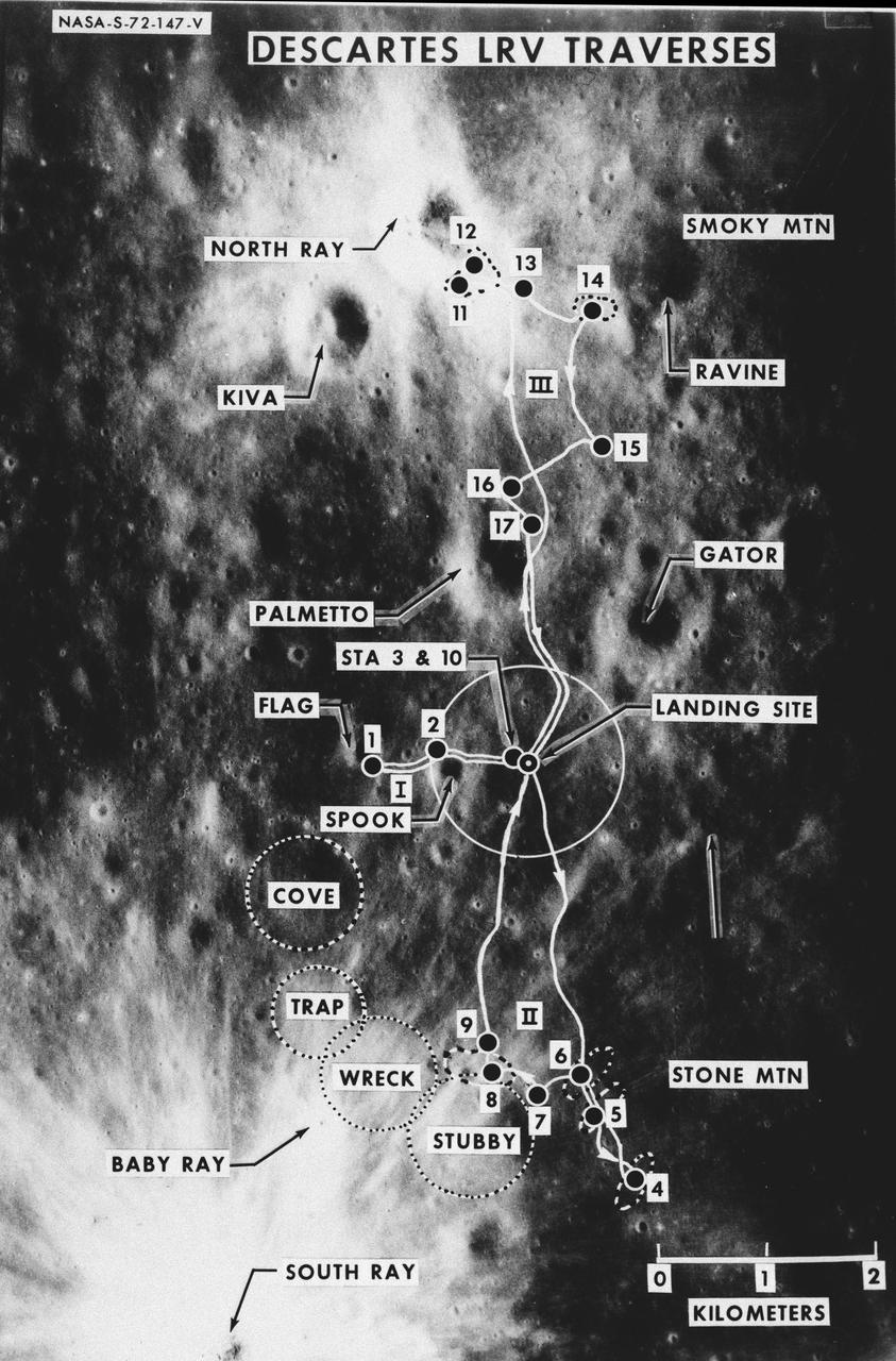
S72-00147 (January 1972) --- An almost vertical view of the Apollo 16 Descartes landing area, as photographed from the Apollo 14 spacecraft. Overlays are provided to point out extravehicular activity (EVA) Lunar Roving Vehicle (LRV) traverse routes and the nicknames of features. Hold picture with South Ray Crater in lower left corner. North will then be at the top. The Roman numerals indicate EVA numbers and the Arabic numbers point out stations or traverse stops.
AS16-120-19237 (April 1972) --- An oblique view of a portion of the lunar nearside as photographed from the Apollo 16 spacecraft in lunar orbit. The small, bright crater is Lassell D at the northeastern edge of Mare Nubium (Sea of Clouds). The area seen in this picture is immediately west of Lassell C Crater, southwest of Guoricke Crater, and southwest of Davy Crater.
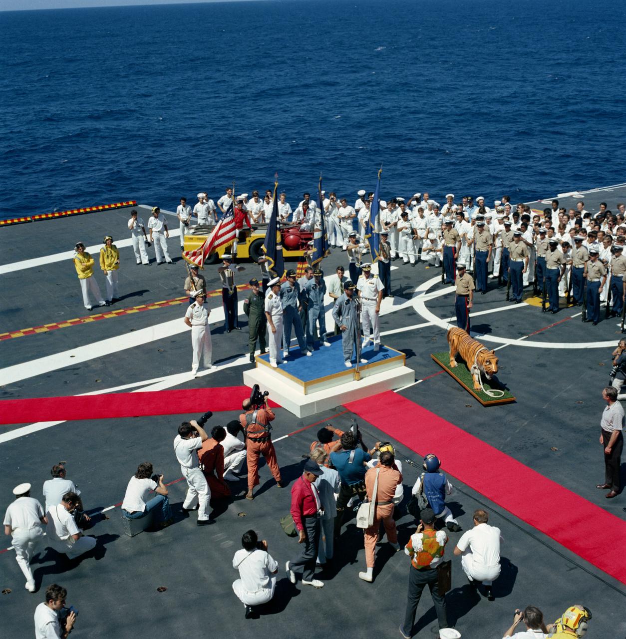
S72-36262 (27 April 1972) --- A high-angle view of the Apollo 16 welcoming aboard ceremonies on the deck of the prime recovery ship, USS Ticonderoga. It was soon after the splashdown of the Apollo 16 Command Module (CM) in the central Pacific Ocean approximately 215 miles southeast of Christmas Island. Astronaut John W. Young, commander, is standing at the microphone. Standing behind Young are astronaut Charles M. Duke Jr. (Left), lunar module pilot; and astronaut Thomas K. Mattingly II, command module pilot. The splashdown occurred at 290:37:06 ground elapsed time, 1:45:06 p.m. (CST), Thursday, April 27, 1972. The coordinates were 00:43.2 degrees south latitude and 156:11.4 degrees west longitude. The three crew members were picked up by helicopter and flown to the deck of the USS Ticonderoga.
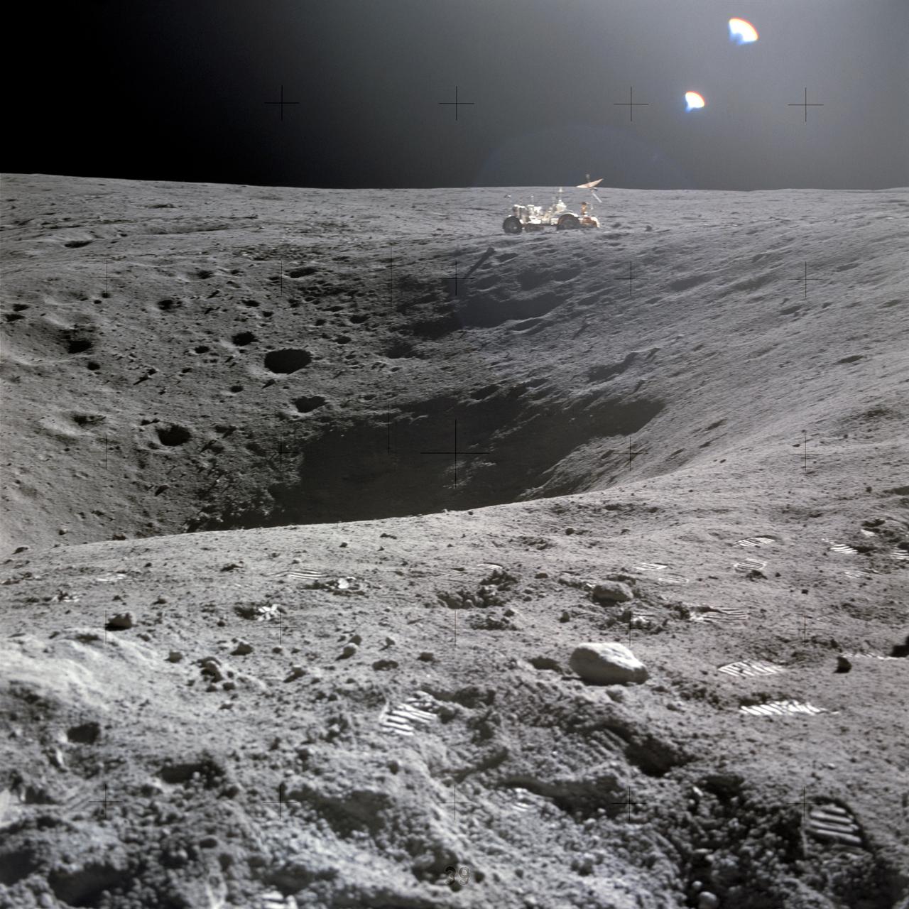
AS16-114-18422 (21 April 1972) --- A view of Plum Crater, which was visited by the two moon-exploring crewmen of the Apollo 16 lunar landing mission, on their first extravehicular activity (EVA) traverse, April 21, 1972. The Lunar Roving Vehicle (LRV) is parked on the far side of the crater, which measures approximately 40 meters in diameter. While astronauts John W. Young, commander; and Charles M. Duke Jr., lunar module pilot; descended in the Apollo 16 Lunar Module (LM) "Orion" to explore the Descartes highlands landing site on the moon, astronaut Thomas K. Mattingly II, command module pilot, remained with the Command and Service Modules (CSM) "Casper" in lunar orbit.

AS16-122-19580 (16-27 April 1972) --- This vertical view shows the King Crater on the lunar surface. It was exposed with color positive film in a hand-held 70mm camera onboard the Command and Service Modules during the Apollo 16 mission's 98th orbit of the moon. Center point coordinates are located at 5.4 degrees north latitude and 120.8 degrees east longitude.

S71-44150 (February 1971) --- A vertical view of the Apollo 16 landing site located in the Descartes area on the lunar nearside. The overlay indicates the location of the proposed touchdown point for the Apollo 16 Lunar Module (LM). Descartes is located west of the Sea of Nectar and southwest of the Sea of Tranquility. This photograph was taken with a 500mm lens camera from lunar orbit by the Apollo 16 crew. Astronauts John W. Young, commander; and Charles M. Duke Jr., lunar module pilot; descended in the Apollo 16 LM "Orion" to explore the Descartes highlands landing site on the moon. Astronaut Thomas K. Mattingly II, command module pilot, remained with the Command and Service Modules (CSM) "Casper" in lunar orbit.
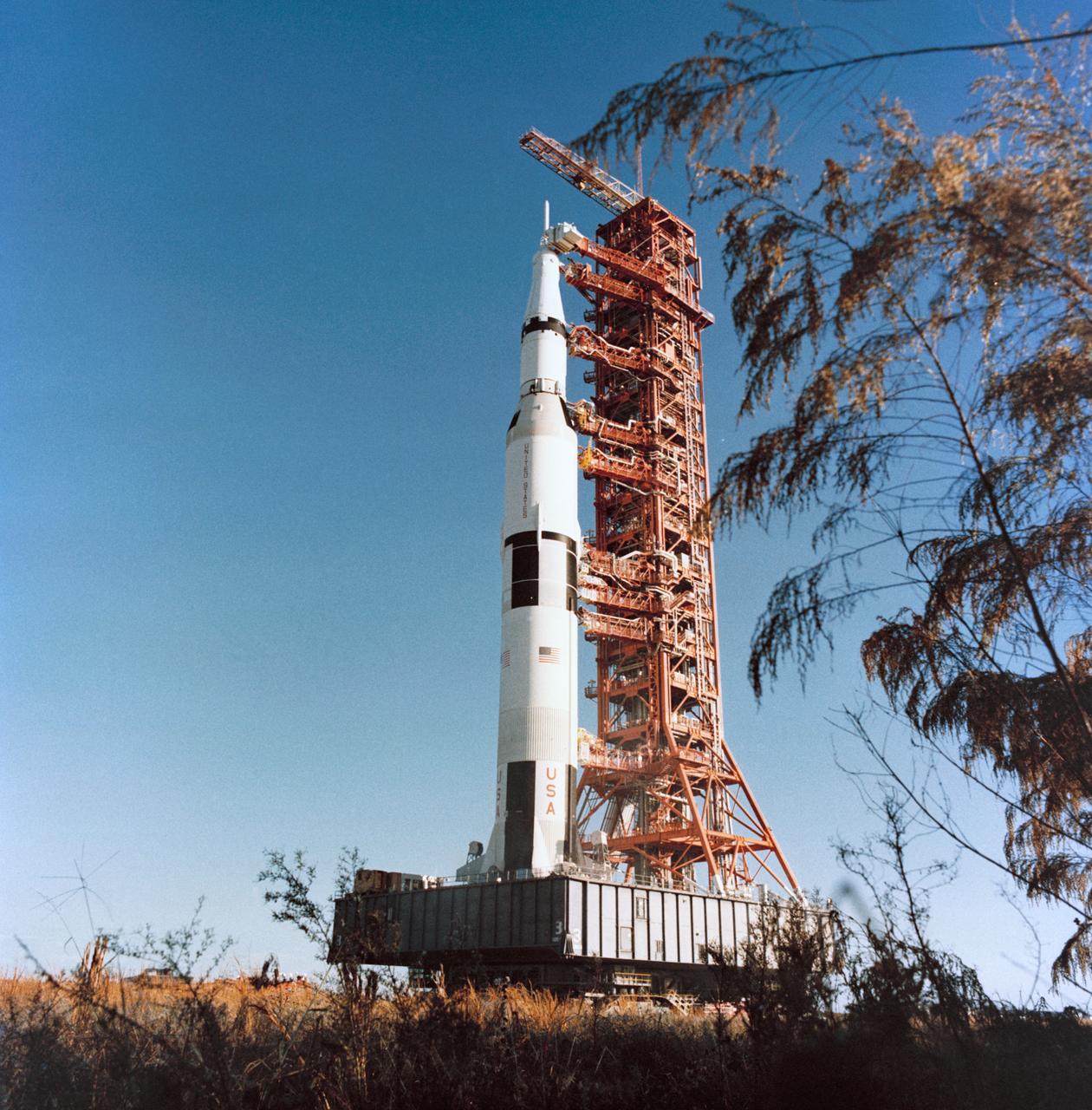
S72-19794 (13 Dec. 1971) --- A ground-level view showing the tall Apollo 16 (Spacecraft 113/Lunar Module 11/Saturn 511) space vehicle at the Kennedy Space Center's (KSC) Launch Complex 39 being moved from the Vehicle Assembly Building (VAB) toward Pad A. The Saturn V stack and its mobile launch tower are atop a huge crawler-transporter. The prime crew men of the scheduled Apollo 16 lunar landing mission are astronauts John W. Young, Apollo 16 lunar landing mission are astronauts John W. Young, commander; Thomas K. Mattingly II, command module pilot; and Charles M. Duke Jr., lunar module pilot.
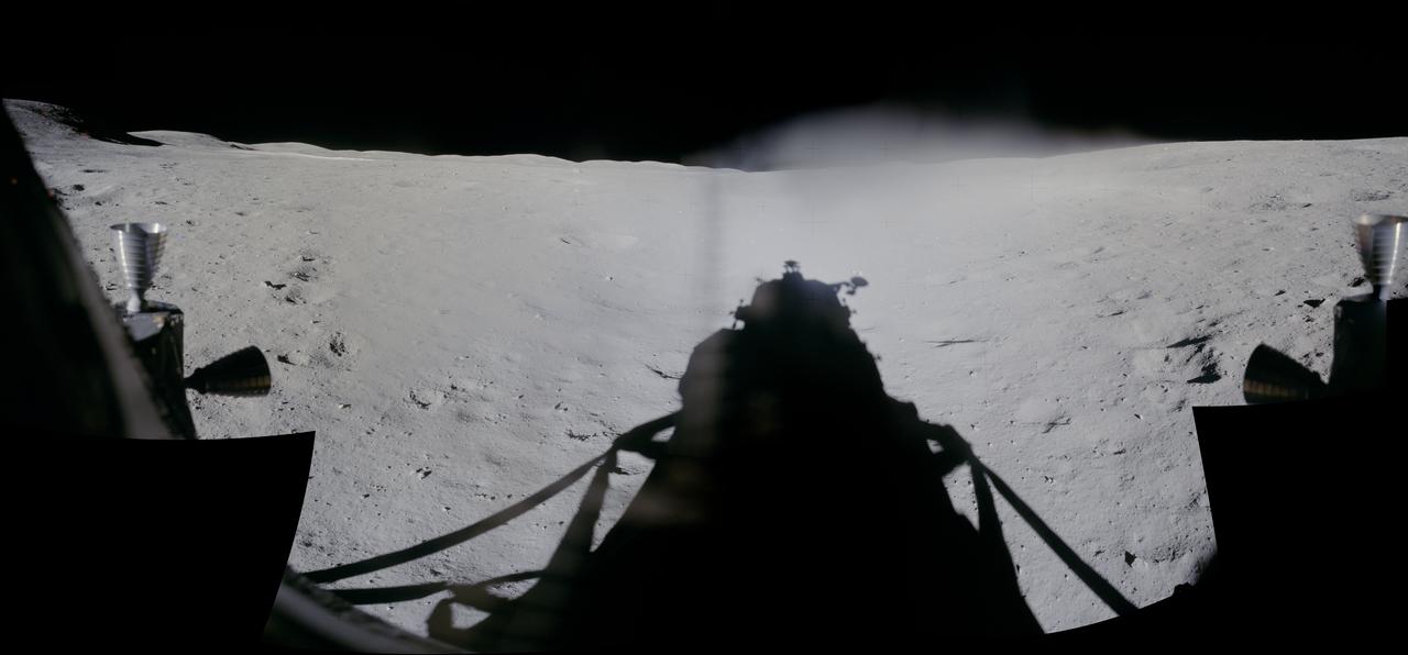
This is a synthetic perspective view looking south from the Apollo 16 landing area, topography is rendered naturally as seen by NASA Lunar Reconnaissance Orbiter.

Cassini whizzed past Dione on Aug. 16, 2006, capturing this slightly motion-blurred view of the moon fractured and broken landscape in reflected light from Saturn
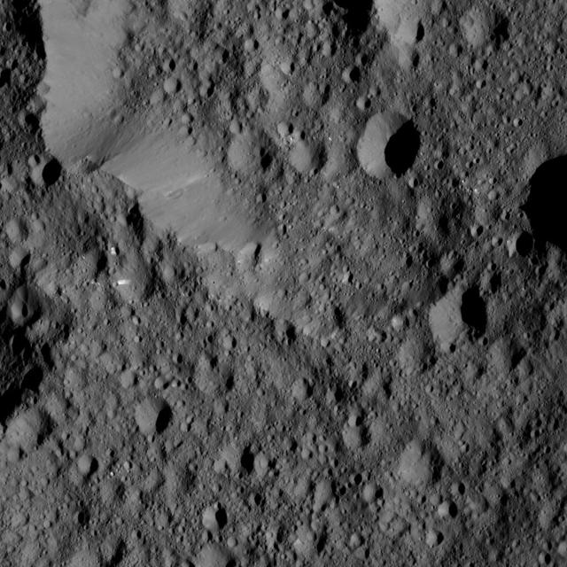
NASA Dawn spacecraft took this view from Ceres on June 16, 2016, showing Ernutet Crater 32 miles, 52 kilometers in diameter at top. NASA's Dawn spacecraft took this image on June 16, 2016, from its low-altitude mapping orbit, at a distance of about 240 miles (385 kilometers) above the surface. The image resolution is 120 feet (35 meters) per pixel. http://photojournal.jpl.nasa.gov/catalog/PIA20833

NASA's Dawn spacecraft views Kupalo Crater in this view of Ceres. Kupalo, which measures 16 miles (26 kilometers) across and is located at southern mid-latitudes, is named for the Slavic god of vegetation and harvest. Dawn took this image on June 2, 2016, from its low-altitude mapping orbit, at a distance of about 240 miles (385 kilometers) above the surface. The image resolution is 120 feet (35 meters) per pixel. http://photojournal.jpl.nasa.gov/catalog/PIA20944
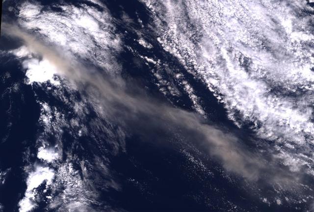
Ash from Iceland Eyjafjallajökull volcano, viewed here in imagery from NASA Terra spacecraft on May 16, 2010, once again disrupted air traffic over Europe with the closure of major airports in the United Kingdom and the Netherlands.
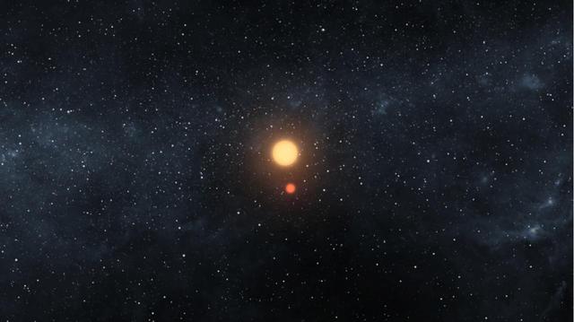
This artist image illustrates the Kepler-16 system from an overhead view, showing the eccentric orbits of the two stars as they twirl around each other every 41 days like figure skaters.

NASA Cassini imaging scientists processed this view of Saturn moon Dione, taken during a close flyby on June 16, 2015. This was Cassini fourth targeted flyby of Dione.
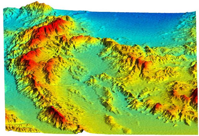
This perspective view acquired by NASA Shuttle Radar Topography Mission SRTM from data collected on February 16, 2000 shows an area of Ventura County, California, including Simi Valley in the center of the image.
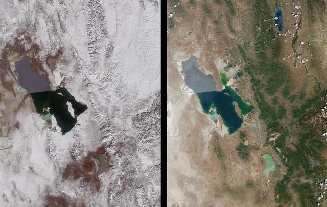
Magnificent views of the region surrounding Salt Lake City, Utah are captured in these winter and summer images from NASA Terra satellite imaged on February 8, 2001 and June 16, 2001.

NASA Cassini imaging scientists processed this view of Saturn moon Dione, taken during a close flyby on June 16, 2015. This was Cassini fourth targeted flyby of Dione.

jsc2011e118362 - Panorama view of Apollo 16 lunar surface photos of the Station 10 and Sample 381 Rock taken during the second moonwalk of the mission. The panoramas were built by combining Apollo 16 images starting with frame AS16-114-18450 thru end frame AS16-114-18467. The panoramic images received minimal retouching by NASA imagery specialists, including the removal of lens flares that were problematic in stitching together the individual frames and blacking out the sky to the lunar horizon. These adjustments were made based on observations of the Moon walkers who reported that there are no stars visible in the sky due to the bright lunar surface reflection of the Sun.
This view from NASA's Magellan spacecraft is a close-up of Atete Corona, a 600-km-long and 450-km-wide feature at latitude 16 degrees S., longitude 244 degrees; looking north. http://photojournal.jpl.nasa.gov/catalog/PIA00097
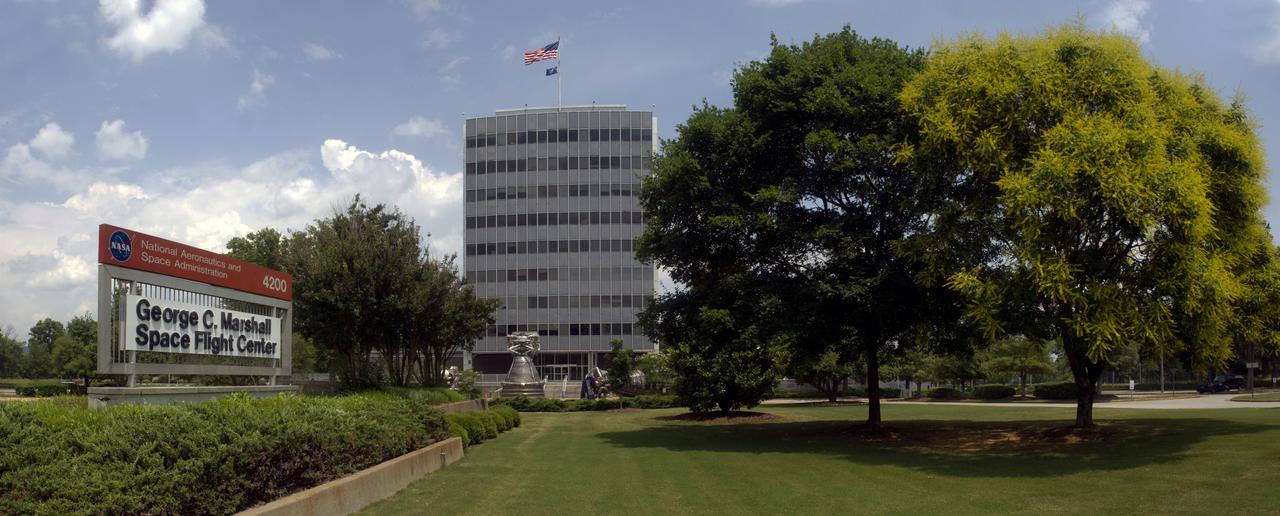
BUILDING 4200, FRONT VIEW, JUNE 16, 2013

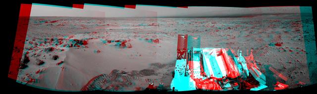
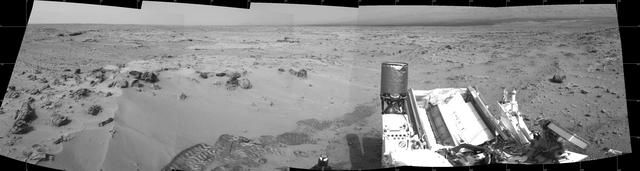
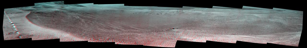
This stereo mosaic of images from NASA Mars Exploration Rover Opportunity shows surroundings of the rover location following an 81-meter 266-foot drive east-northeastward on Sept. 16, 2010. 3D glasses are necessary to view this image.
NASA Mars rover Curiosity drove 6.2 feet 1.9 meters during the 100th Martian day, or sol, of the mission Nov. 16, 2012. The rover used its Navigation Camera after the drive to record the images combined into this 3-D panoramic view.
NASA Mars rover Curiosity drove 6.2 feet 1.9 meters during the 100th Martian day, or sol, of the mission Nov. 16, 2012. The view spans from north at the left to south-southeast at the right. It is presented in a cylindrical projection.
This three-dimensional perspective view, looking up the Tigil River, acquired by NASA Shuttle Radar Topography Mission SRTM from data collected on February 16, 2000, shows the western side of the volcanically active Kamchatka Peninsula, Russia.
NASA's Curiosity Mars rover captured this view of its robotic arm during sunset on Sept. 16, 2025, the 4,661st Martian day, or sol, of the mission. This series of six images shows the rover's 7-foot-long (2.5-meter-long) arm setting its turret, a rotating platform for science instruments, onto rock targets nicknamed "Turbio" and "Rio Aguas Blancas." The front hazard cameras, located on the front of the rover's chassis, took the images between 3:55 and 4:51 p.m. local Mars time, showcasing the lengthening shadows at the end of the day. The sun finally set at 4:54 p.m. local Mars time. Animation available at https://photojournal.jpl.nasa.gov/catalog/PIA26673
Aerial view of Press Site, May 16, 2011, as the crowd prepares for the final launch of Space Shuttle Endeavour
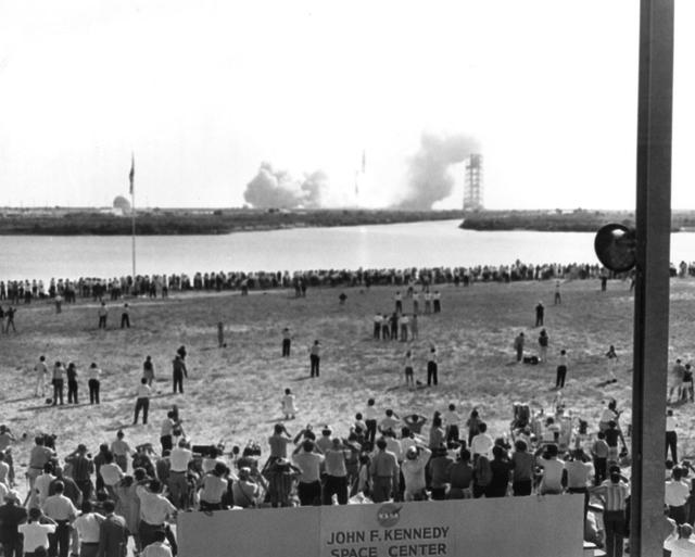
View of Complex 39 Press Site during Apollo 11 launch, July 16, 1969
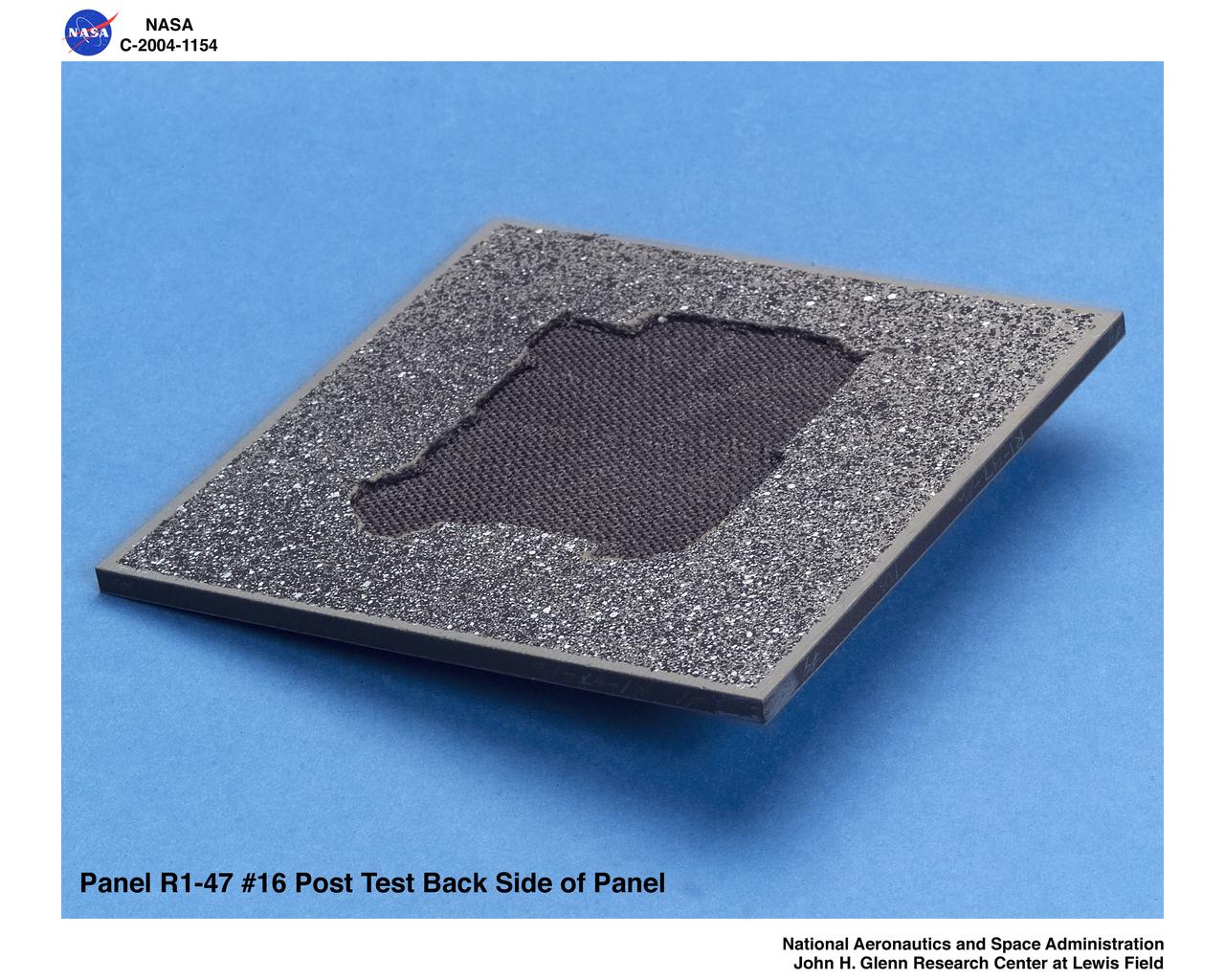
carbon/carbon fiber panels, panel R1-47-16 post test isometric view of back side

S65-61887 (16 Dec. 1965) --- A water level view of Navy divers with the Gemini 6 spacecraft.
Russian Return EVA16, 17 Part 207 pt2
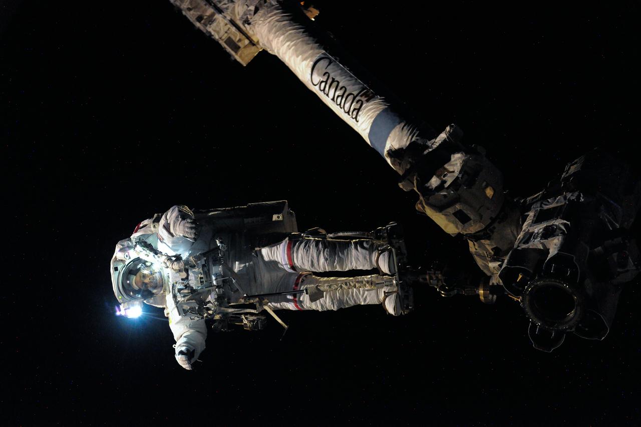
Russian Return EVA16, 17 Part 207 pt2
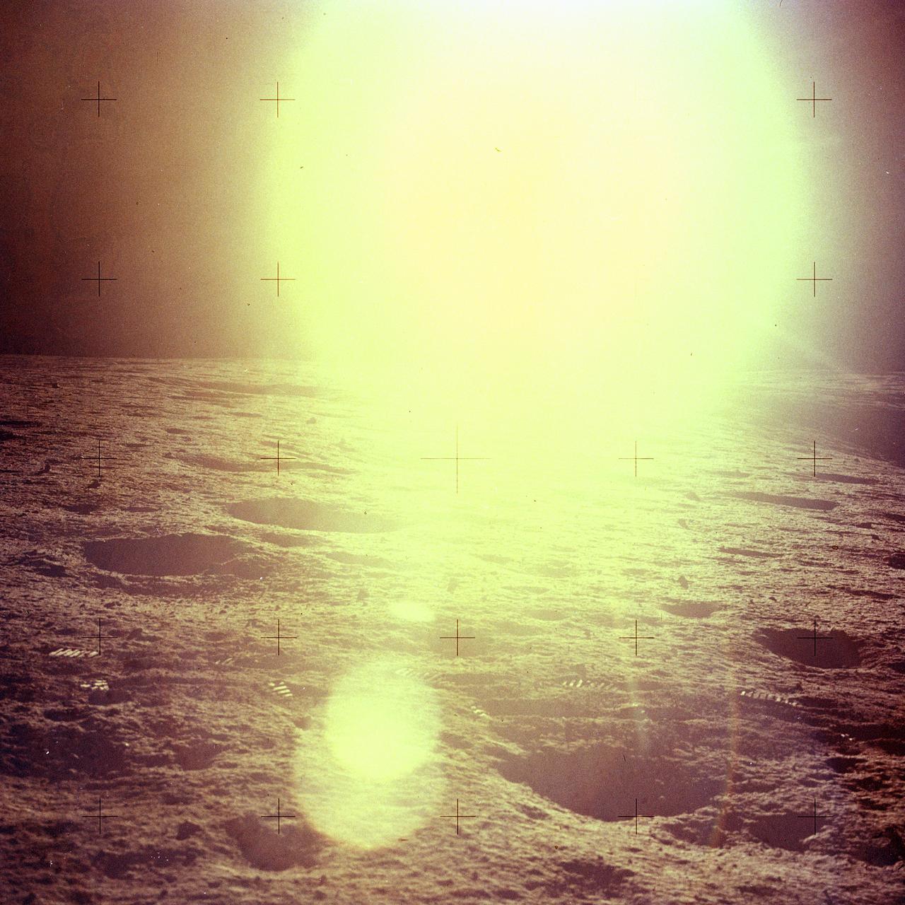
jsc2011e118363 - Panorama view of Apollo 16 commander Astronaut John W. Young, working at the Lunar Roving Vehicle (LRV) just prior to deployment of the Apollo Lunar Surface Experiments Package (ALSEP) during the first moonwalk of the mission on April 21, 1972. The panoramas were built by combining Apollo 16 images starting with frame AS16-116-18573 thru end frame AS16-116-18581. The panoramic images received minimal retouching by NASA imagery specialists, including the removal of lens flares that were problematic in stitching together the individual frames and blacking out the sky to the lunar horizon. These adjustments were made based on observations of the Moon walkers who reported that there are no stars visible in the sky due to the bright lunar surface reflection of the Sun.
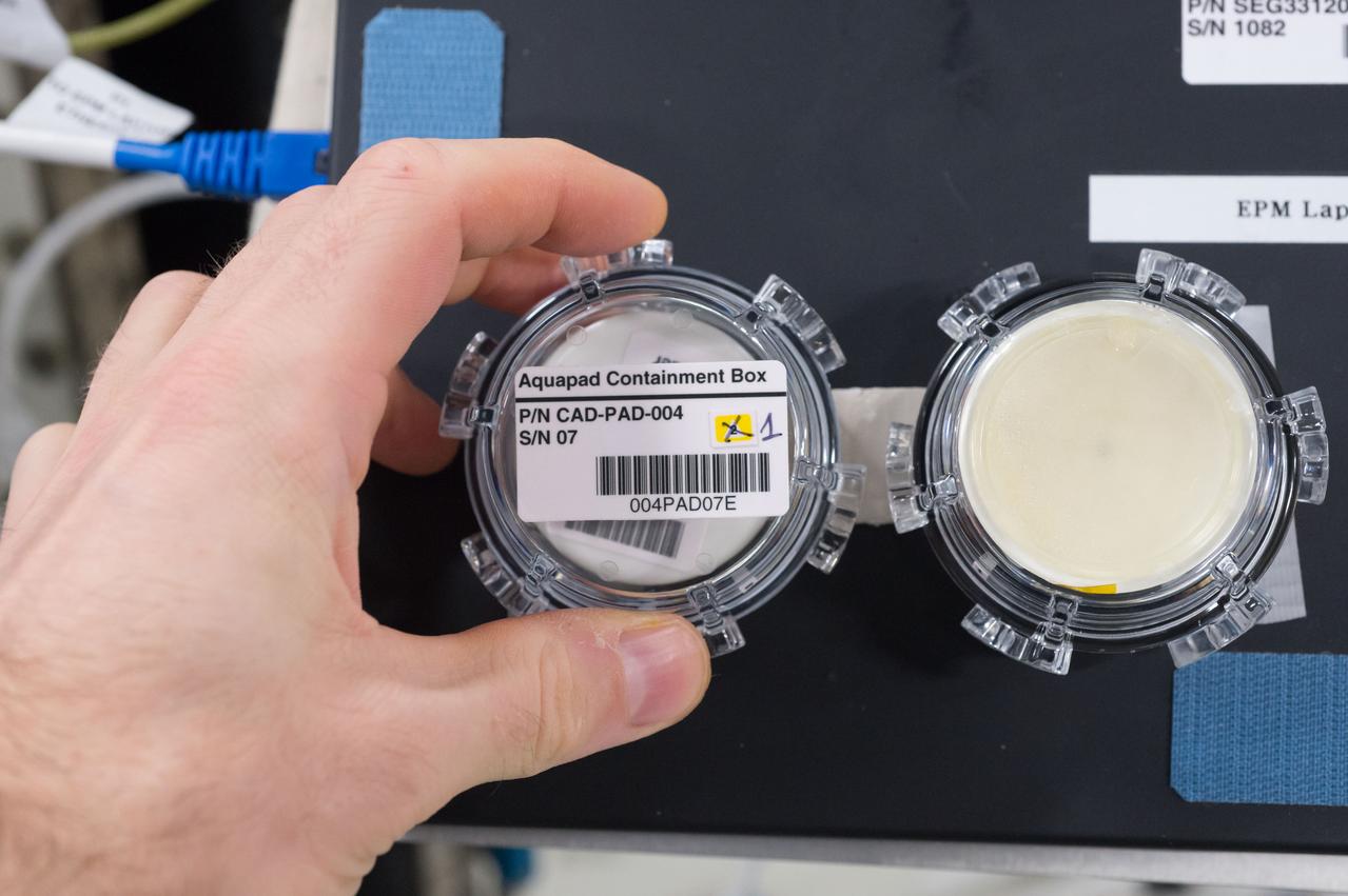
iss050e057692 (3/16/2017) --- View of Aquapad Microbial Contamination within container during analysis of water samples. Photo was taken during Expedition 50.
Panorama view of Apollo 16 Lunar surface photos for use in presentations to NASA management and for Outreach Education in regard to new NASA initiative for human planetary research. Photo numbers used for this panoramic include: Apollo 16 start frame AS16-117-18805 thru end frame AS16-117-18823.

STS112-382-003 (16 October 2002) --- Backdropped by the blackness of space, this full view of the International Space Station (ISS) was photographed by a crewmember on board the Space Shuttle Atlantis following the undocking of the two spacecraft. Atlantis pulled away from the complex at 8:13 a.m. (CDT) on October 16, 2002.
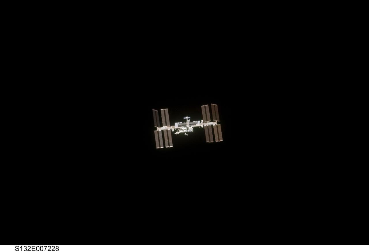
S132-E-007228 (16 May 2010) --- Surrounded by the blackness of space, the International Space Station appears to be very small from the point of view of space shuttle Atlantis as the shuttle approaches the station during STS-132 rendezvous and docking operations. Docking occurred at 9:28 a.m. (CDT) on May 16, 2010.
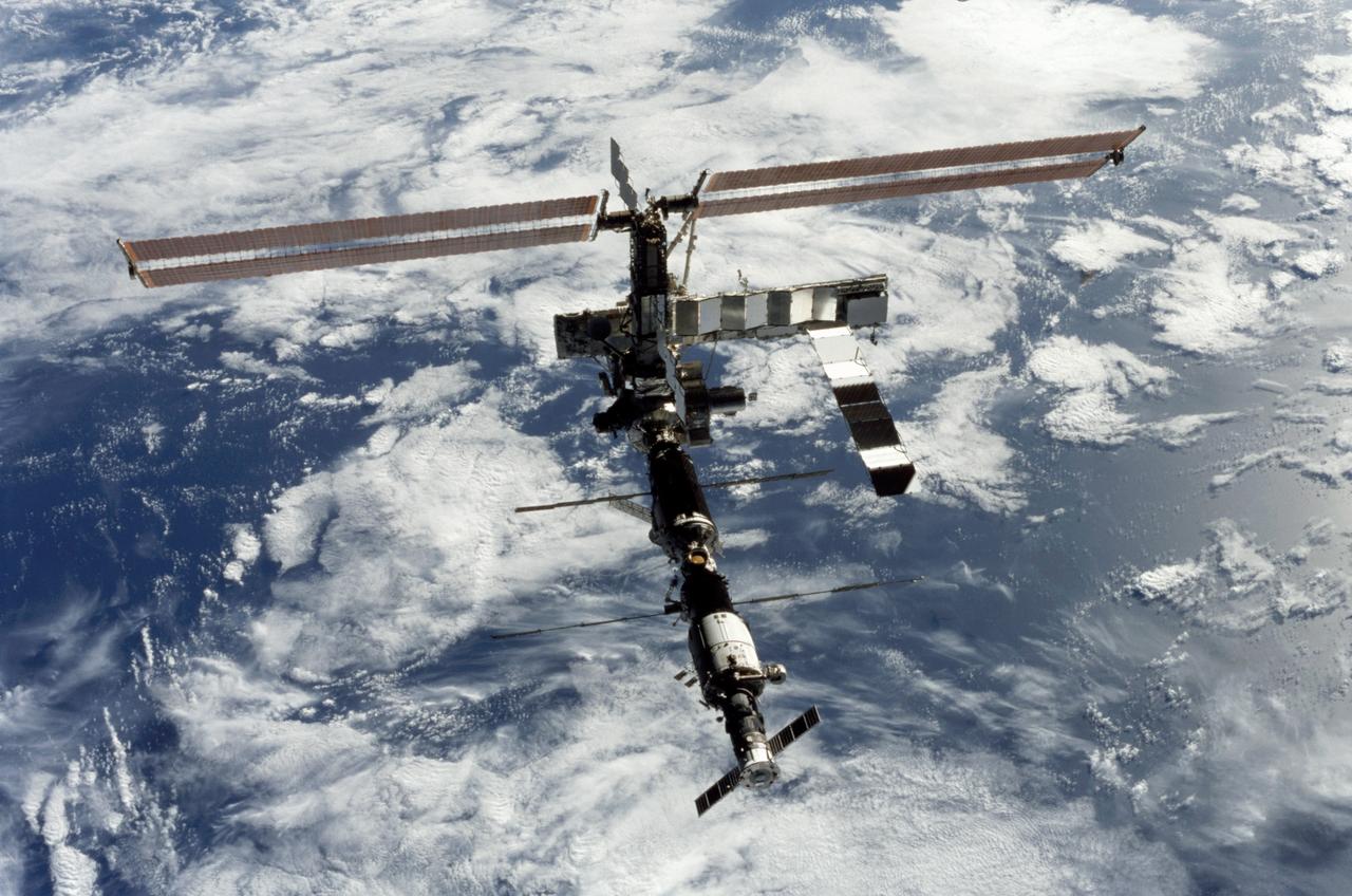
STS112-375-033 (16 October 2002) --- Backdropped by a blue and white Earth, this full view of the International Space Station (ISS) was photographed by a crewmember on board the Space Shuttle Atlantis following the undocking of the two spacecraft. Atlantis pulled away from the complex at 8:13 a.m. (CDT) on October 16, 2002.
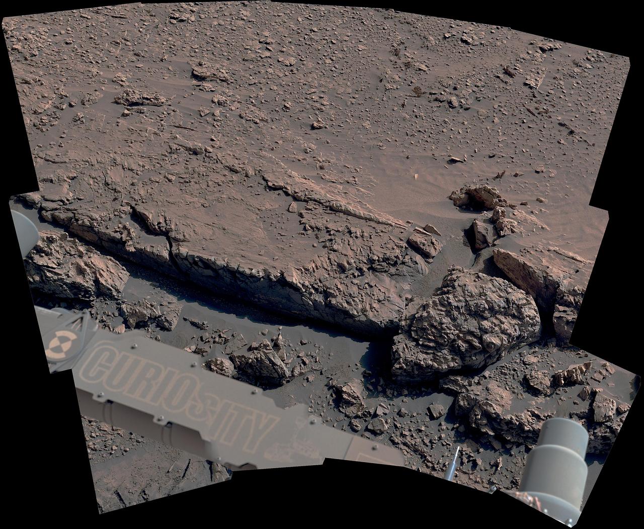
The curblike ridge in this view is part of a series of crisscrossing features that form what's called a boxwork pattern. NASA's Curiosity Mars rover captured the image with its Mast Camera, or Mastcam, on May 16, 2025, the 4,541st Martian day, or sol, of the mission. This panorama was stitched together from 15 individual images. The color in these images has been adjusted to match the lighting conditions as the human eye would see them on Earth. When viewed from space, the boxwork patterns look a bit like spiderwebs. They have fascinated scientists since before Curiosity's 2012 landing on the Red Planet and are believed to have formed from groundwater trickling through rock cracks billions of years ago. Minerals left behind by the water hardened like cement within the rock; after eons of sandblasting by wind, the rock was carved away, revealing networks of resistant ridges within. https://photojournal.jpl.nasa.gov/catalog/PIA26558
This view of a small, relatively fresh crater on Mars combines images from the left eye and right eye of the Panoramic Camera (Pancam) on NASA's Opportunity Mars rover, to appear three-dimensional when seen through blue-red glasses with the red lens on the left. The rover paused beside the crater in April 2017, during the 45th anniversary of the Apollo 16 mission to the moon. The rover team chose to call it "Orion Crater," after the Apollo 16 lunar module. The crater's diameter is about 90 feet (27 meters). From the small amount of erosion or filling that Orion Crater has experienced, its age is estimated at no more than 10 million years. It lies on the western rim of Endeavour Crater. For comparison, Endeavor is about 14 miles (22 kilometers) in diameter and more than 3.6 billion years old. The component images were taken on April 26, 2017, during the 4,712th Martian day, or sol, of Opportunity's work on Mars. Apollo 16 astronauts John Young and Charles Duke flew in the Orion lunar module to and from the first human landing in the lunar highlands while Ken Mattingly orbited the moon in the command module, Casper. On the moon, Young and Duke investigated Plum Crater, which is approximately the same size as Mars' Orion Crater. https://photojournal.jpl.nasa.gov/catalog/PIA21706

S66-24406 (16 March 1966) --- Close-up view of astronaut David R. Scott, pilot of the Gemini-8 spaceflight, making final adjustments and checks in the spacecraft during the Gemini-8 prelaunch countdown. In the background almost out of view is astronaut Neil A. Armstrong, command pilot. Photo credit: NASA

ISS043E198683 (05/16/2015) --- NASA astronaut Scott Kelly on the International Space Station took this Earth observation photo in the stations cupola that provides a 360 degree view. He tweeted this image with the comment: "The view out my window. #CapeTown #SouthAfrica. #YearInSpace".
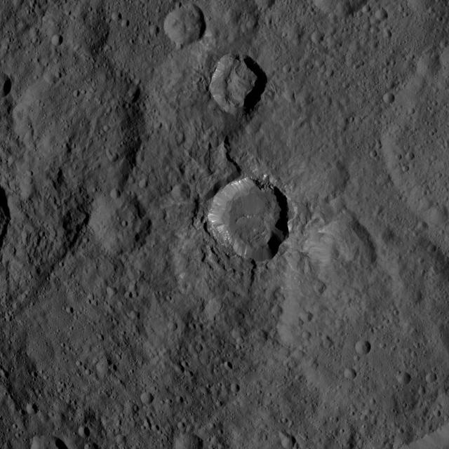
This view of Ceres from NASA's Dawn spacecraft shows a fresh impact crater with a flat floor. The crater is surrounded by smooth, flow-like ejecta that covers adjacent older impact craters. The crater is about 16 miles (26 kilometers) in diameter. The image was taken Oct. 9, 2015, from an altitude of 915 miles (1,470 kilometers). It has a resolution of 450 feet (140 meters) per pixel. The image is located at 31 degrees south latitude, 176 degrees east longitude. http://photojournal.jpl.nasa.gov/catalog/PIA20124

Attendees view exhibits during NASA’s Day on the Hill, Tuesday, Sept. 16, 2025, at the Hart Senate Office Building in Washington. Photo Credit: (NASA/Joel Kowsky)
S68-50712 (16 Sept. 1968) --- Nighttime view of Launch Complex 34, Kennedy Space Center, showing the Apollo 7 (Spacecraft 101/Saturn 205) stack on pad.

Attendees view exhibits during NASA’s Day on the Hill, Tuesday, Sept. 16, 2025, at the Hart Senate Office Building in Washington. Photo Credit: (NASA/Joel Kowsky)

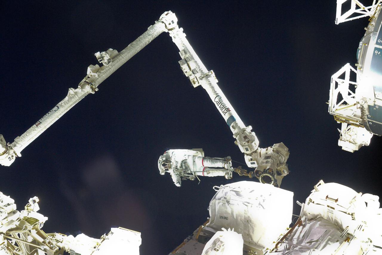
iss064e033716 (Feb. 16, 2020) --- This top-down view shows a pair of U.S. spacesuits set up for maintenance work inside the International Space Station's Quest airlock where spacewalks in the U.S. segment are staged.

S125-E-007900 (16 May 2009) --- A nadir view of cloud vortices in the area of the Canary Islands in the North Atlantic Ocean was recorded by one of the STS-125 crewmembers on a busy flight day six.
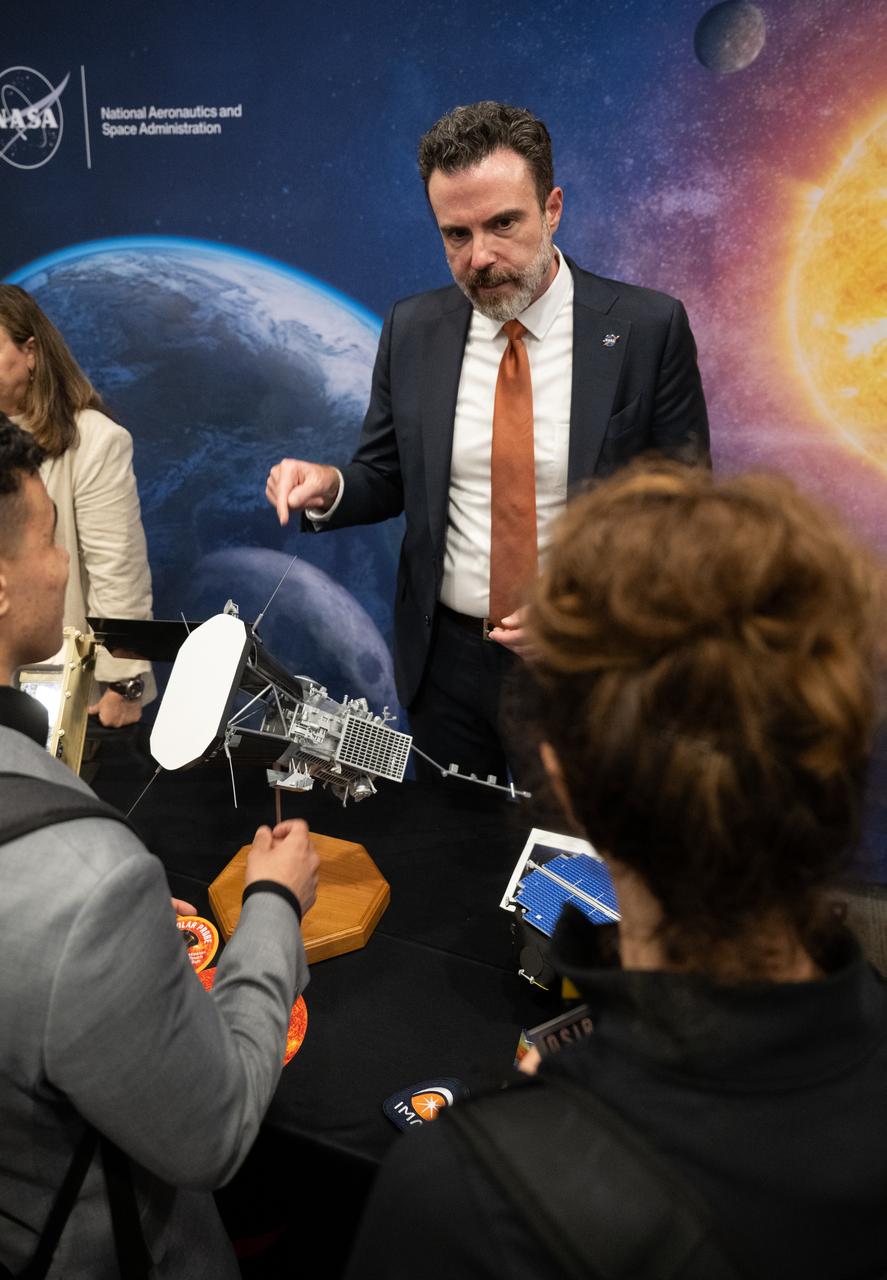
Attendees view exhibits during NASA’s Day on the Hill, Tuesday, Sept. 16, 2025, at the Hart Senate Office Building in Washington. Photo Credit: (NASA/Joel Kowsky)

S66-25781 (16-17 March 1966) --- Closer view of the Agena Target Docking vehicle seen from the Gemini-8 spacecraft during rendezvous in space. Photo credit: NASA
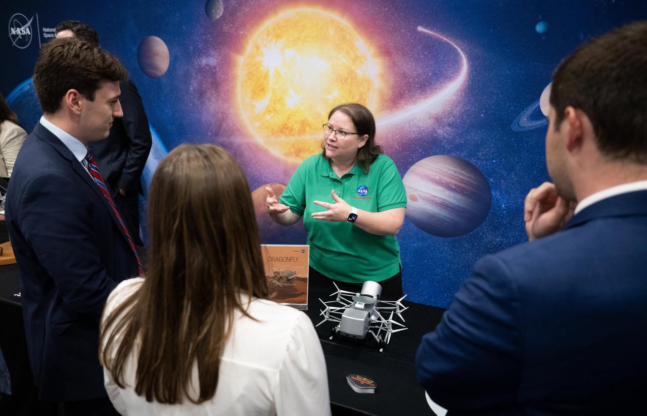
Attendees view exhibits during NASA’s Day on the Hill, Tuesday, Sept. 16, 2025, at the Hart Senate Office Building in Washington. Photo Credit: (NASA/Joel Kowsky)
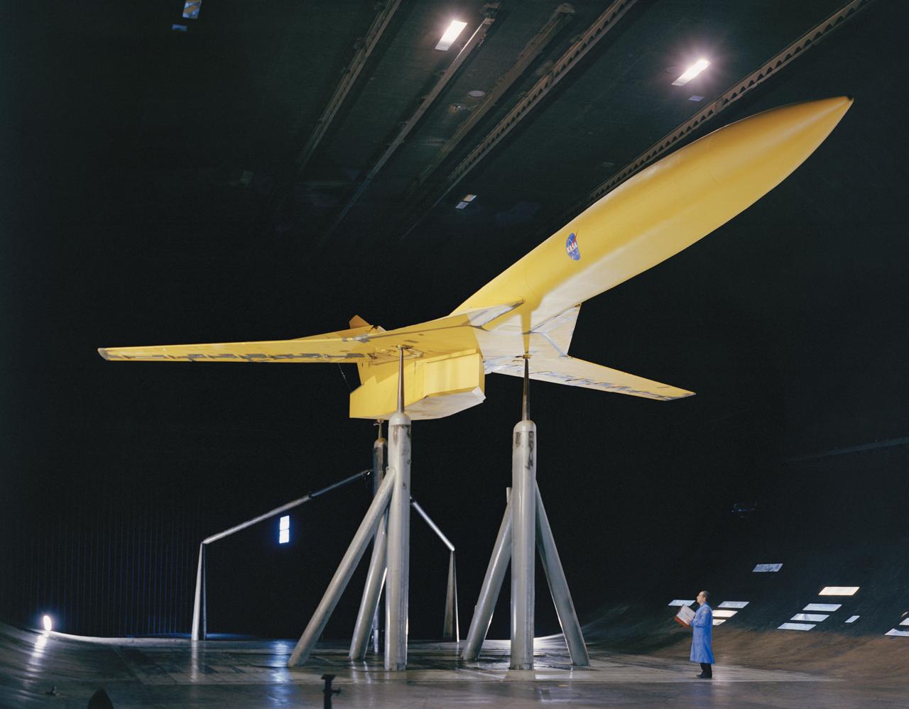
3/4 view of model in cruise configuration with 25 deg. Sweep, AR=6.9. SCAT-16; Variable Sweep Model in 40x80 Wind Tunnel at NASA Ames.

S73-34367 (16 Nov. 1973) --- A view at the Kennedy Space Center showing in the near distance the Skylab 4/Saturn 1B space vehicle on Pad B, Launch Complex 39, on the morning of the launch. Photo credit: NASA
STS102-324-028 (16 March 2001) --- The moon and Earth's limb were viewed from the Space Shuttle Discovery as it flew over the central Pacific Ocean with stratocumulus clouds below.
Distant view of the Orbital Sciences Cygnus cargo craft approaching the International Space Station, photographed by an Expedition 40 crew member. The two spacecraft converged at 6:36 a.m. (EDT) on July 16, 2014.
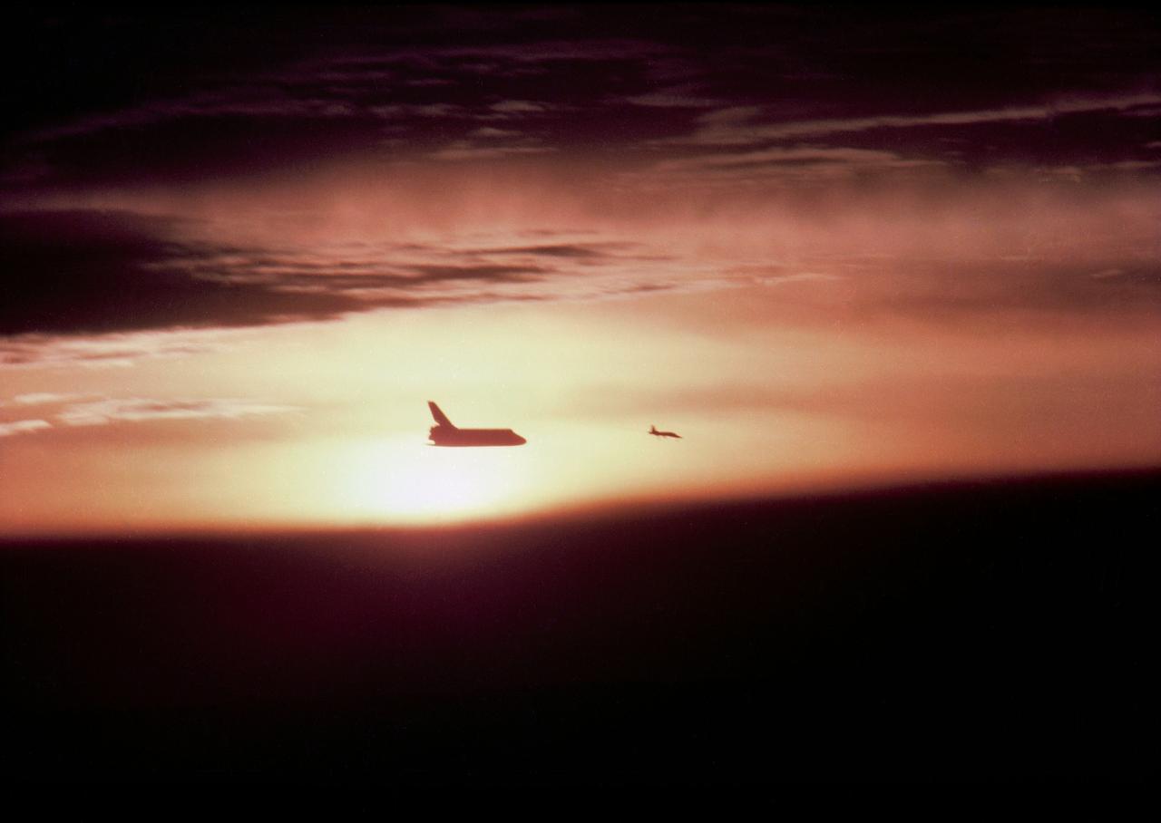
Aerial view of Orbiter "Columbia" as you look into the Sun, taken by Erik Simonsen, Rockwell International, 11/16/1982. 1. STS-5 - LANDING (INTO THE SUN) EAFB, CA

Attendees view exhibits during NASA’s Day on the Hill, Tuesday, Sept. 16, 2025, at the Hart Senate Office Building in Washington. Photo Credit: (NASA/Joel Kowsky)
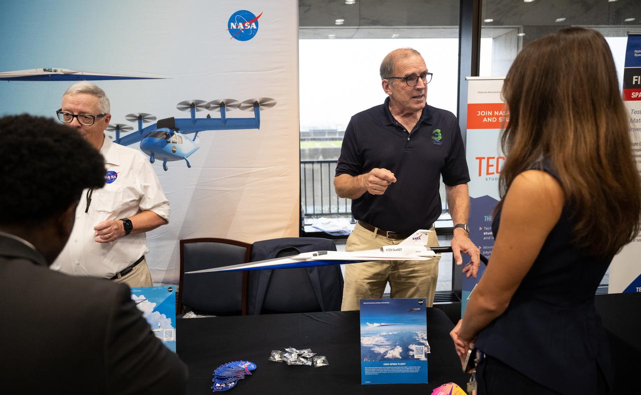
Attendees view exhibits during NASA’s Day on the Hill, Tuesday, Sept. 16, 2025, at the Hart Senate Office Building in Washington. Photo Credit: (NASA/Joel Kowsky)

S66-25782 (16 March 1966) --- Closer view of the Agena Target Docking vehicle seen from the Gemini-8 spacecraft during rendezvous in space. Photo credit: NASA
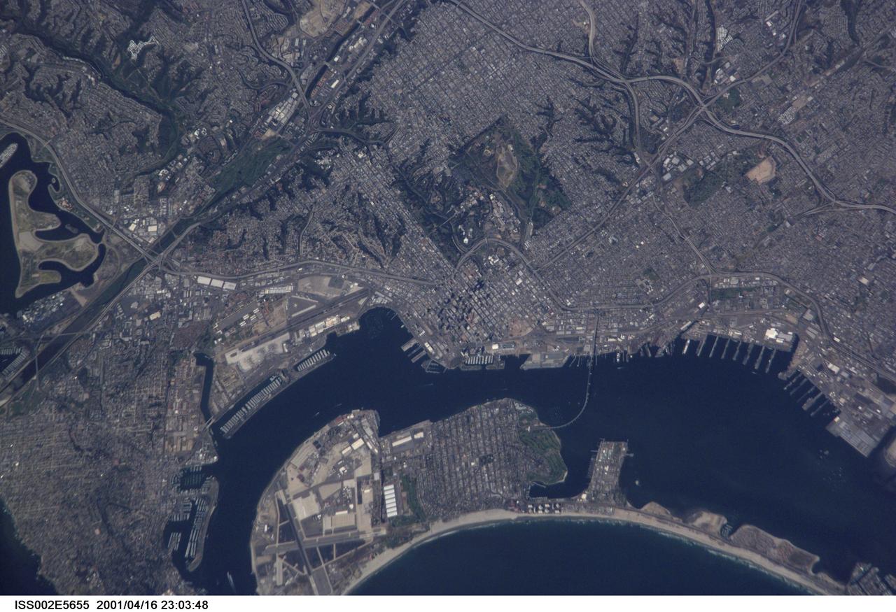
ISS002-E-5655 (16 April 2001) --- A detailed vertical view of San Diego, California, was provided by a digital still camera by the Expedition Two crew onboard the International Space Station (ISS).
Distant view of the Orbital Sciences Cygnus cargo craft approaching the International Space Station, photographed by an Expedition 40 crew member. The two spacecraft converged at 6:36 a.m. (EDT) on July 16, 2014.
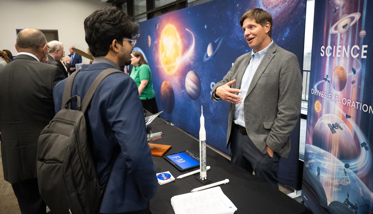
Attendees view exhibits during NASA’s Day on the Hill, Tuesday, Sept. 16, 2025, at the Hart Senate Office Building in Washington. Photo Credit: (NASA/Joel Kowsky)

iss047e154247 (6/16/2016) --- View of Commander Tim Kopra exercising on the Cycle Ergometer with Vibration Isolation and Stabilization (CEVIS) in the U.S. Laboratory. Photo was taken during Expedition 47.
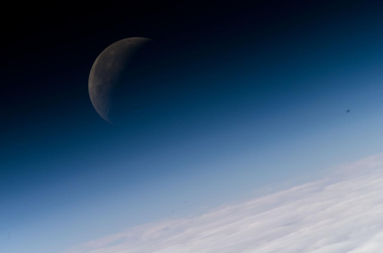
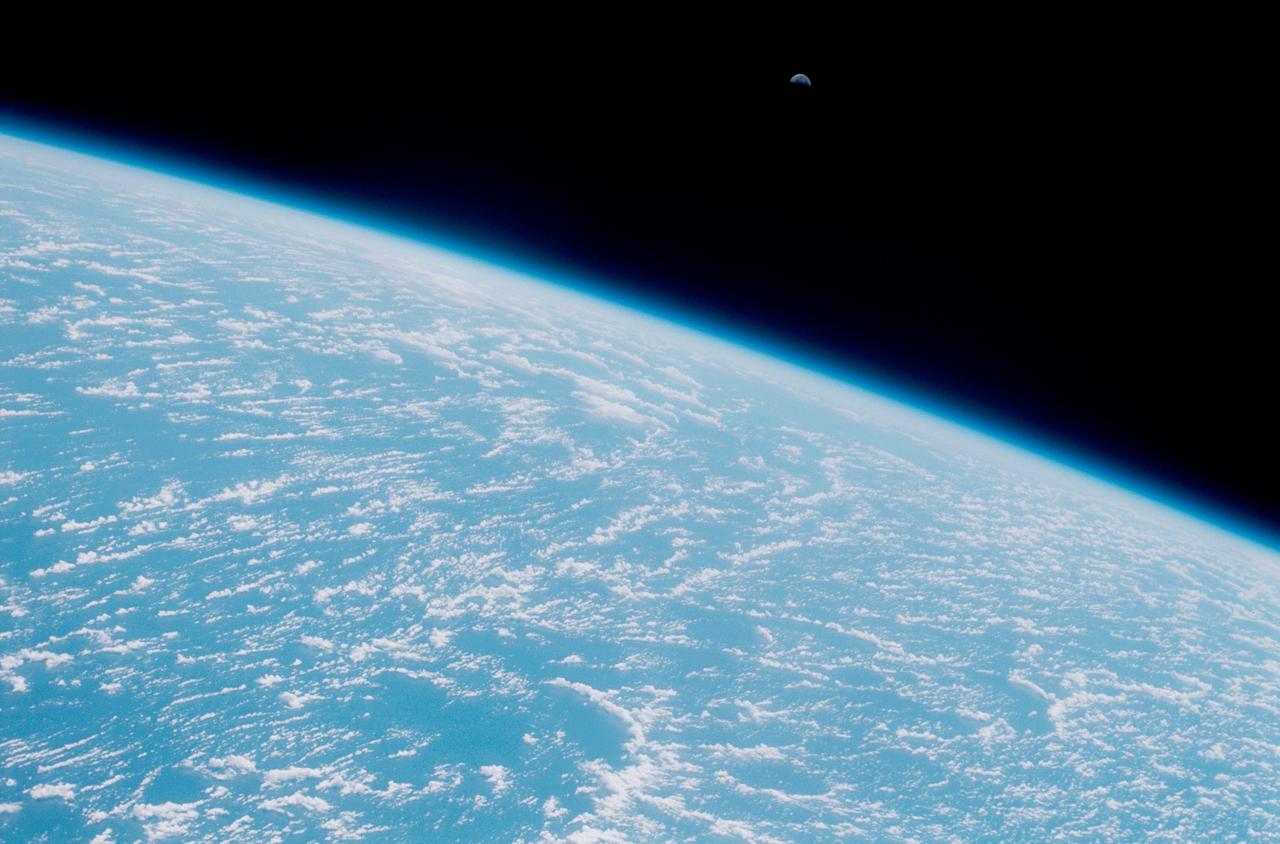
ISS016-E-008867 (3 Nov. 2007) --- A gibbous moon is visible in this view of Earth's horizon and atmosphere, photographed by an Expedition 16 crewmember on the International Space Station while Space Shuttle Discovery (STS-120) is docked with the station.

Attendees view exhibits during NASA’s Day on the Hill, Tuesday, Sept. 16, 2025, at the Hart Senate Office Building in Washington. Photo Credit: (NASA/Joel Kowsky)
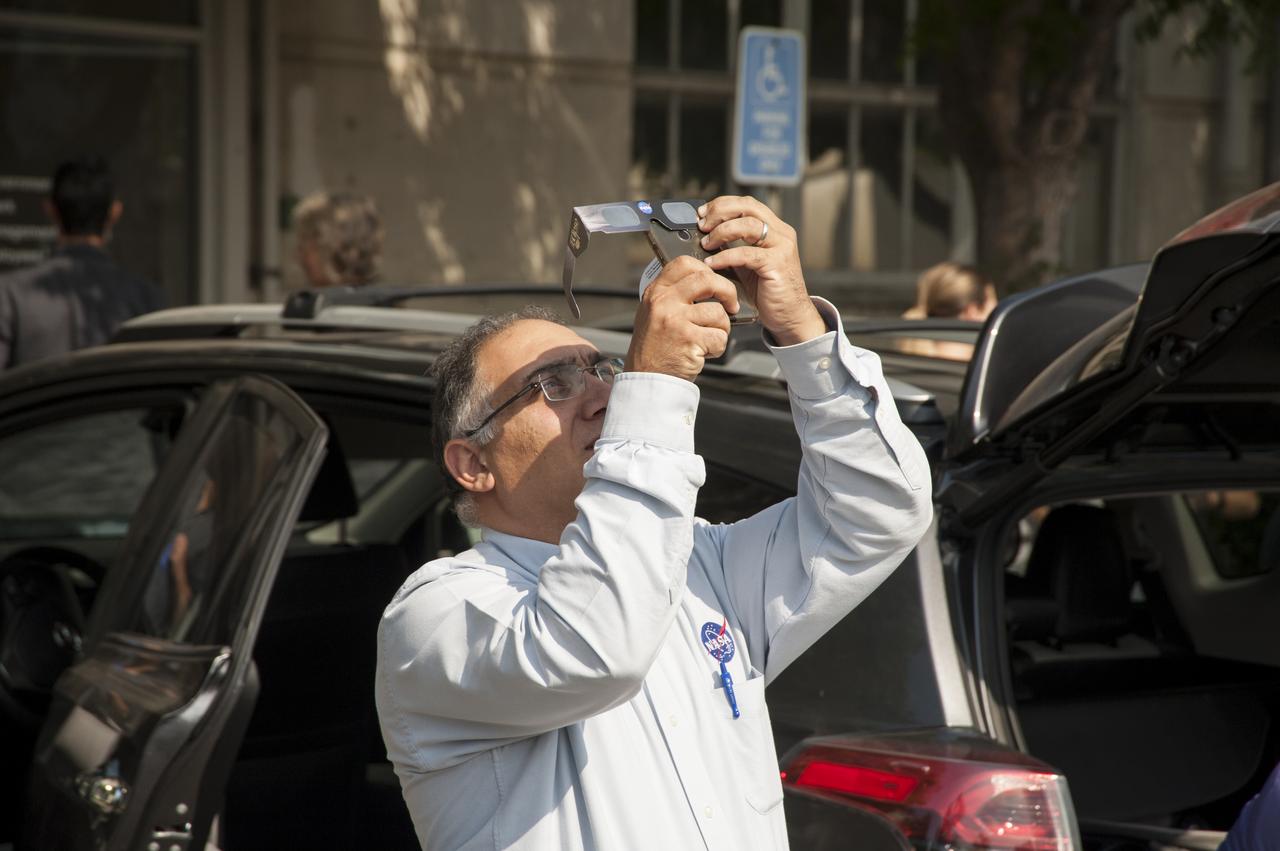
Taking a break from his duties at Ames Research Center Jacob Cohen, Ames Chief Scientist grabs his own view of the 2017 Solar Eclipse with his cellphone at 09:16:11 on August 21, 2017.

iss055e024450 (April 16, 2018) --- This oblique view shows the southern tip of the Mexican state of South Baja California as the International Space Station orbited off Mexico's Pacific coast

A general view of a hearing in front of the Senate Subcommittee on Strategic Forces and Senate Committee on Commerce, Science, and Transportation regarding assured access to space on Wednesday, July 16, 2014, at the Hart Senate Office Building in Washington, DC.

On August 21, 2017, the first total solar eclipse to move across the United States in 99 years occurred. GOES-16 captured the eclipse with the Advanced Baseline Imager (ABI) which had a clear view of the moon’s shadow as it traveled diagonally across the path of totality of the Continental United States from the Pacific Northwest through South Carolina. In this full disk geocolor image from GOES-16 on August 21, 2017, the center of the moon's shadow is now east of the Mississippi River. Credit: CIRA View more eclipse imagery at <a href="http://www.nesdis.noaa.gov/content/multimedia" rel="nofollow">www.nesdis.noaa.gov/content/multimedia</a>
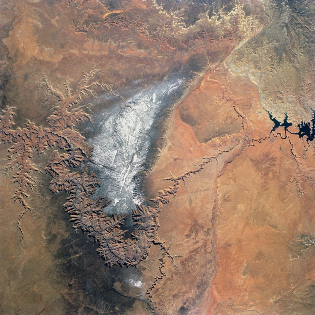
Snow covers the Kaibab Plateau on the northern side of the Colorado River in this November, 1994 view of the Grand Canyon. North is to the bottom of this view. The Colorado River has created a canyon which cuts through billions of years of geologic time. The Grand Canyon is 446 kilometers (277 miles) long, averages 16 kilometers (10 miles) wide, and is approximately 1.6 kilometers (1 mile) deep. The Coconino Plateau is located on the upper left side of the view, or to the south of the Colorado River. The direction of the flow of the Colorado River is from the east to the west. Eventually the river turns south and empties into the Gulf of California. The southern portion of Lake Powell in Utah can be seen at the bottom center of the view.
jsc2012e052597 - Panorama view from the Apollo 16 Lunar Module (LM) window taken on-orbit during Revolution 16 of the mission. The panoramas were built by combining Apollo 16 images starting with frame AS16-113-18297 thru end frame AS16-113-18307. The panoramic images received minimal retouching by NASA imagery specialists, including the removal of lens flares that were problematic in stitching together the individual frames and blacking out the sky to the lunar horizon. These adjustments were made based on observations of the Moon walkers who reported that there are no stars visible in the sky due to the bright lunar surface reflection of the Sun.
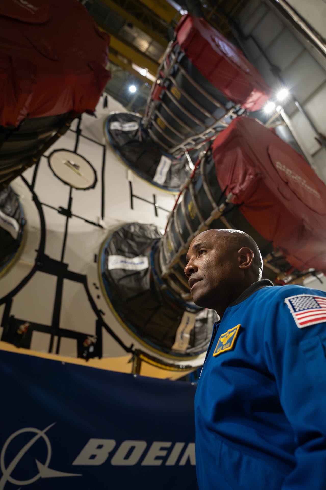
NASA astronaut Victor Glover views the core stage of the SLS (Space Launch System) rocket that will help power Artemis II at NASA’s Michoud Assembly Facility in New Orleans July 15. Glover will pilot Artemis II, the first crewed mission of NASA’s Artemis campaign. Crews moved the 212-foot-tall core stage with its four RS-25 engines to Building 110 at NASA Michoud prior to rolling it out to NASA’s Pegasus barge July 16 for delivery to NASA’s Kennedy Space Center in Florida.
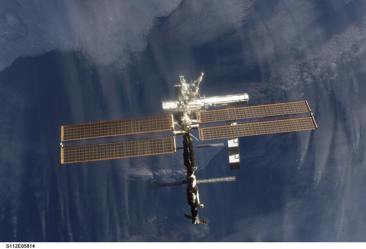
STS112-E-05814 (16 October 2002) --- Backdropped by a dark blue and white Earth, this full view of the International Space Station (ISS) was photographed by a crewmember on board the Space Shuttle Atlantis following the undocking of the two spacecraft. Atlantis pulled away from the complex at 8:13 a.m. (CDT) on October 16, 2002. The newly added Starboard One (S1) Truss is visible in center frame.
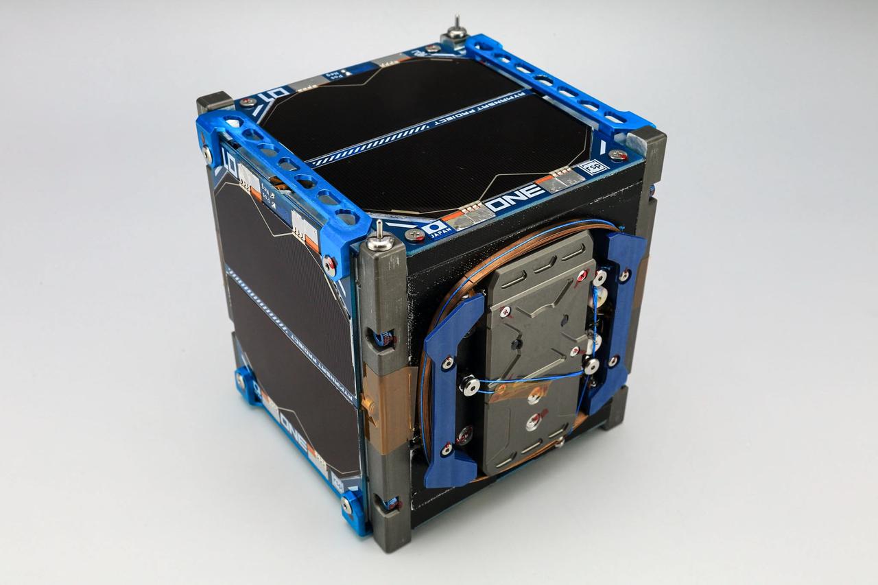
jsc2021e004420 (10/3/2020) --- A pre-flight view of the top of the RSP-01 Flight Model. The RSP-01 satellite is a 1-Unit (1U) CubeSat that deploys during the JEM Small Satellite Orbital Deployer-16 (J-SSOD-16) micro-satellite deployment mission and is handled by the Japanese Experiment Module Remote Manipulator System (JEMRMS). RSP-01 is developed by Rymansat Spaces and launches to the International Space Station aboard the NG-15 Cygnus Cargo Vehicle. Image Credit: Rymansat Spaces.
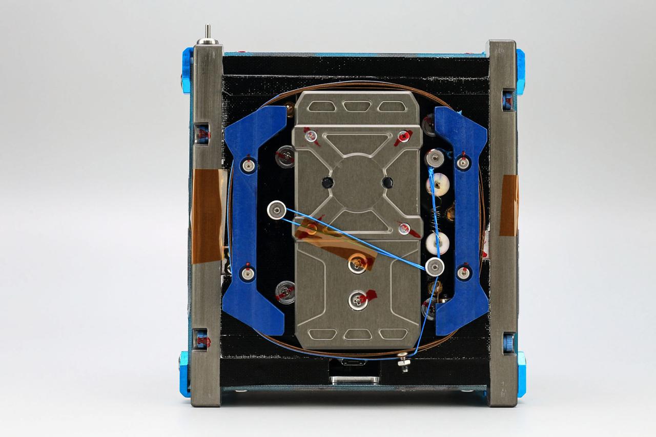
jsc2021e004417 (10/6/2020) --- A pre-flight view of the RSP-01 Flight Model. The RSP-01 satellite is a 1-Unit (1U) CubeSat that deploys during the JEM Small Satellite Orbital Deployer-16 (J-SSOD-16) micro-satellite deployment mission and is handled by the Japanese Experiment Module Remote Manipulator System (JEMRMS). RSP-01 is developed by Rymansat Spaces and launches to the International Space Station aboard the NG-15 Cygnus Cargo Vehicle. Image Credit: Rymansat Spaces.
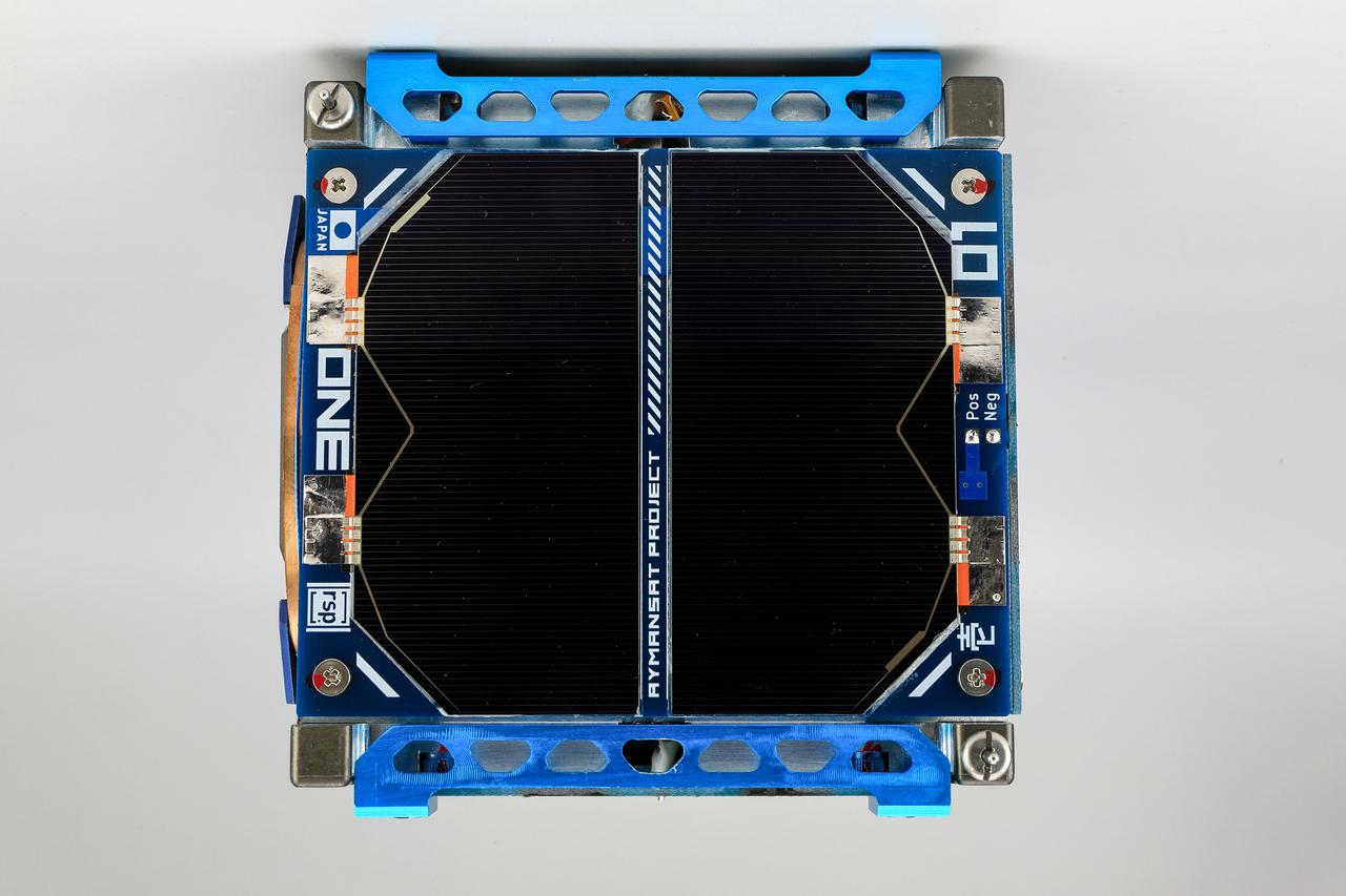
jsc2021e004418 (10/6/2020) --- A pre-flight view of the front side of the RSP-01 Flight Model. The RSP-01 satellite is a 1-Unit (1U) CubeSat that deploys during the JEM Small Satellite Orbital Deployer-16 (J-SSOD-16) micro-satellite deployment mission and is handled by the Japanese Experiment Module Remote Manipulator System (JEMRMS). RSP-01 is developed by Rymansat Spaces and launches to the International Space Station aboard the NG-15 Cygnus Cargo Vehicle. Image Credit: Rymansat Spaces.

jsc2021e004419 (10/27/2020) --- A pre-flight view of the RSP-01 Robot Arm Deployment. The RSP-01 satellite is a 1-Unit (1U) CubeSat that deploys during the JEM Small Satellite Orbital Deployer-16 (J-SSOD-16) micro-satellite deployment mission and is handled by the Japanese Experiment Module Remote Manipulator System (JEMRMS). RSP-01 is developed by Rymansat Spaces and launches to the International Space Station aboard the NG-15 Cygnus Cargo Vehicle. Image Credit: Rymansat Spaces.
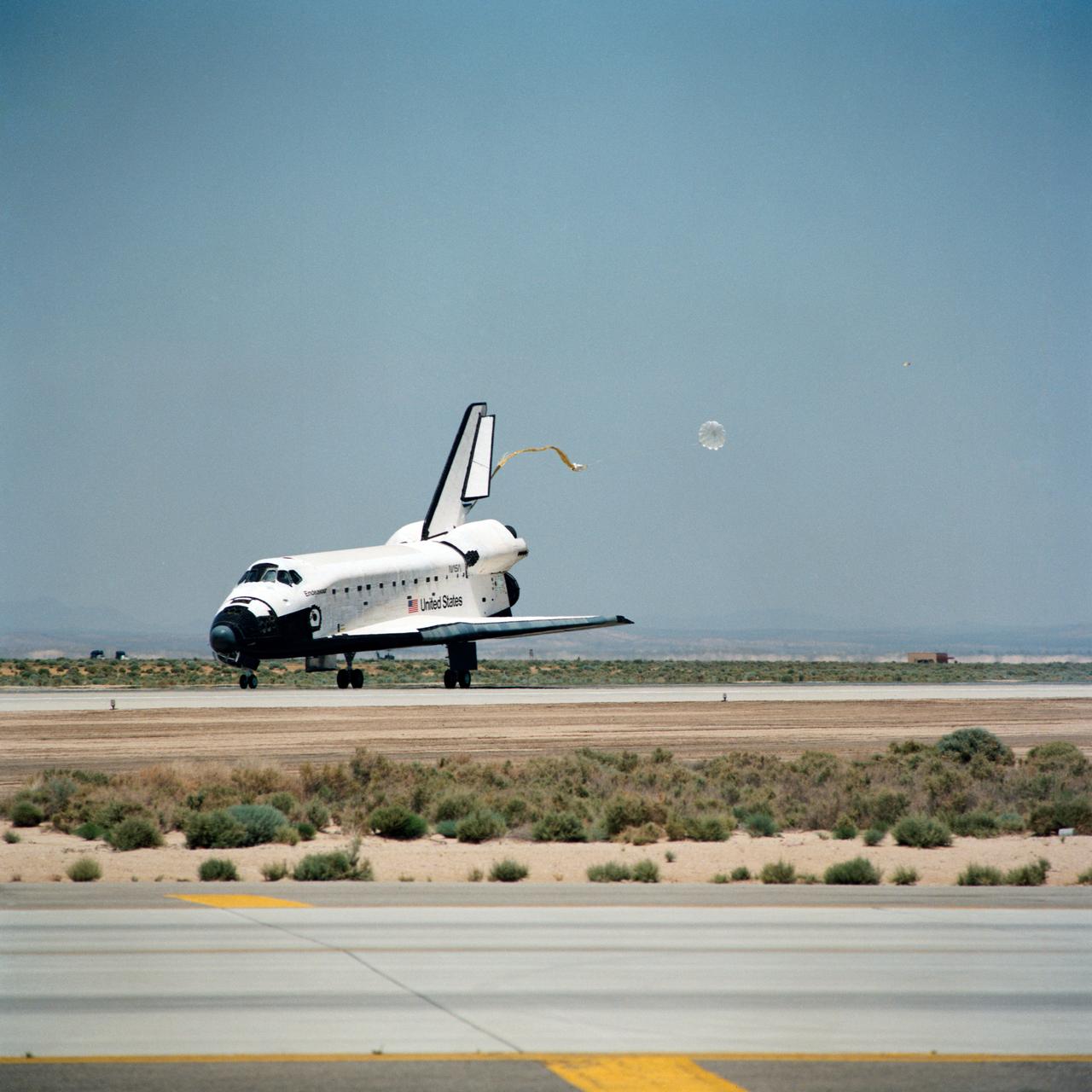
STS049-S-268 (16 May 1992) --- A three-quarter forward view of the Space Shuttle Endeavour making its first landing, following a successful nine-day mission in Earth orbit. The drogue chute precedes the main chute in NASA's first exercise of its detailed test objective (DTO-521) on the drag chute system. Main gear touchdown occurred at 1:57:38 p.m. (PDT), May 16, 1992.
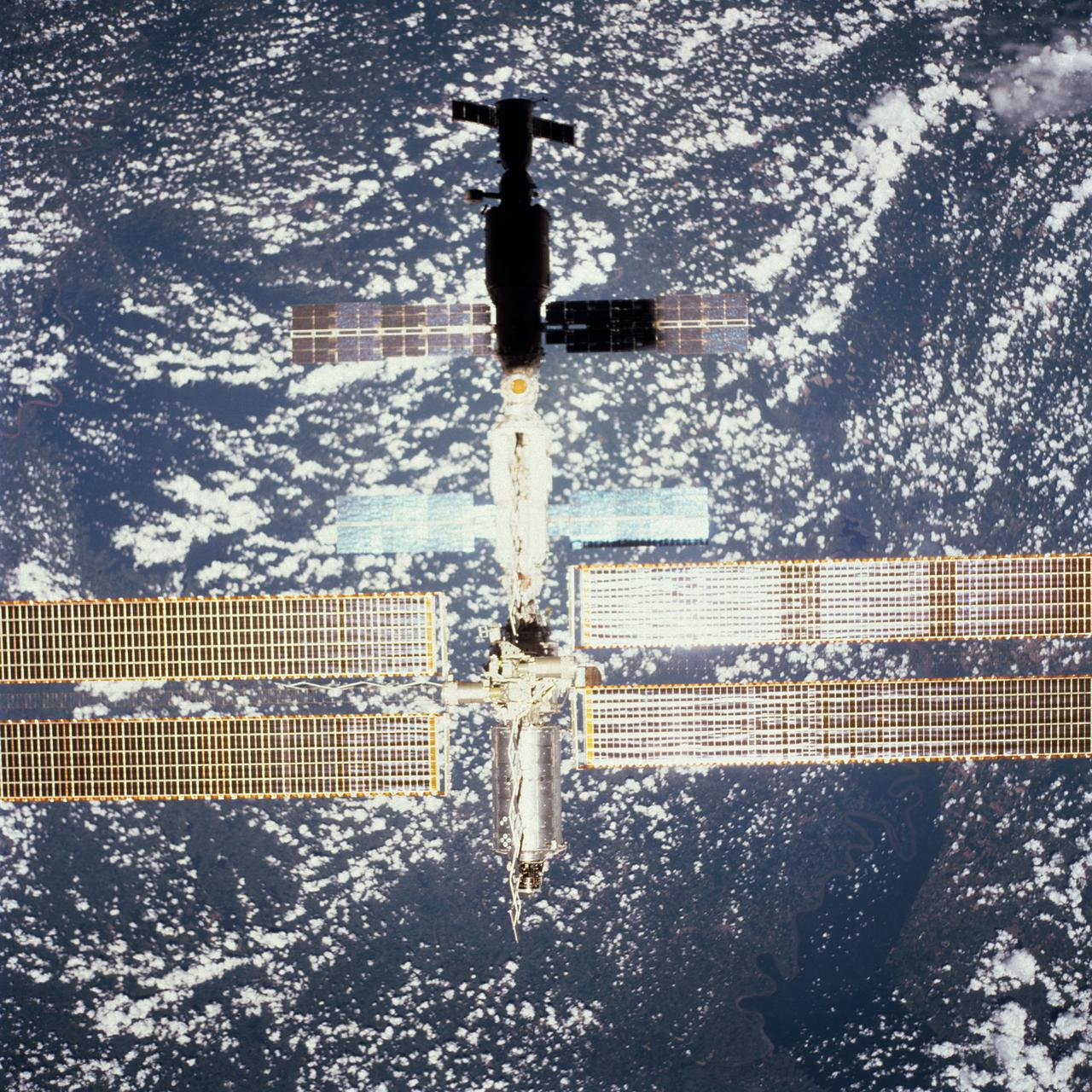
STS098-713A-075 (16 February 2001) --- Backdropped by Earth dotted with clouds, this close-up view of the International Space Station (ISS) with the newly-attached Destiny laboratory, was photographed by one of the astronauts onboard Atlantis. As the primary payload for the STS-98 mission, Destiny is the centerpiece of the ISS, where unprecedented science experiments will be performed in space. The shuttle and the station parted company at 8:06 a.m. (CST), Feb. 16, as Polansky flew the shuttle halfway around the outpost and its new Destiny laboratory before moving off.

STS112-382-019 (16 October 2002) --- A long distance view of the International Space Station (ISS) was photographed by a crewmember on board the Space Shuttle Atlantis following the undocking of the two spacecraft. Atlantis pulled away from the complex at 8:13 a.m. (CDT) on October 16, 2002. Atlantis’ vertical stabilizer is visible in the foreground. A cloud-covered Earth provides the backdrop for the scene.