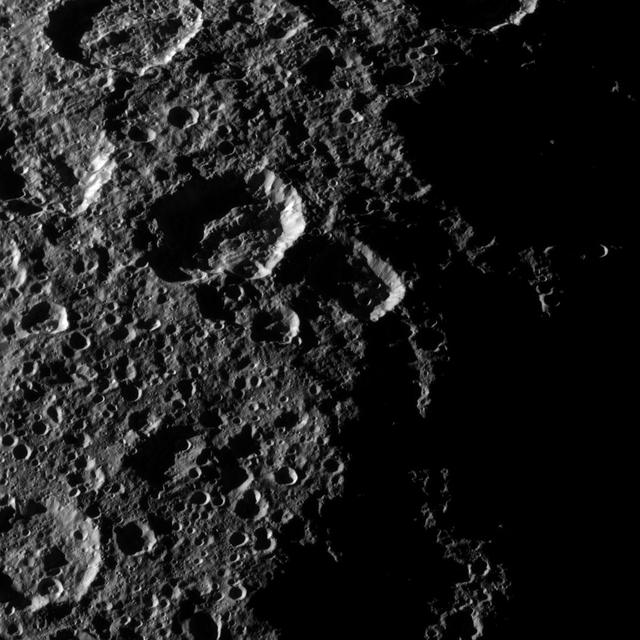
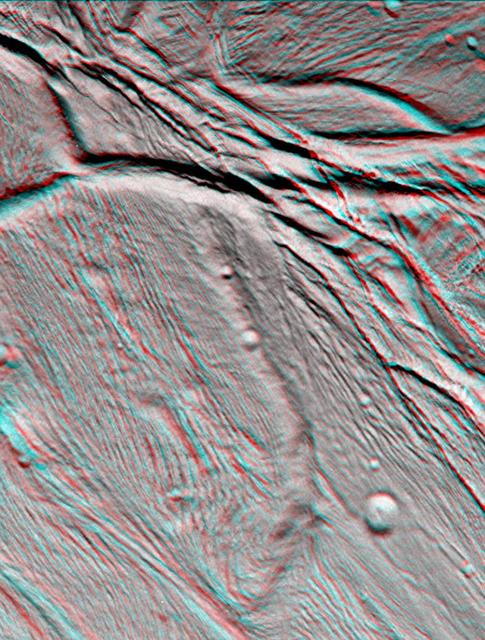
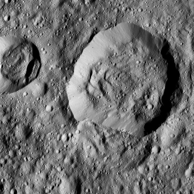
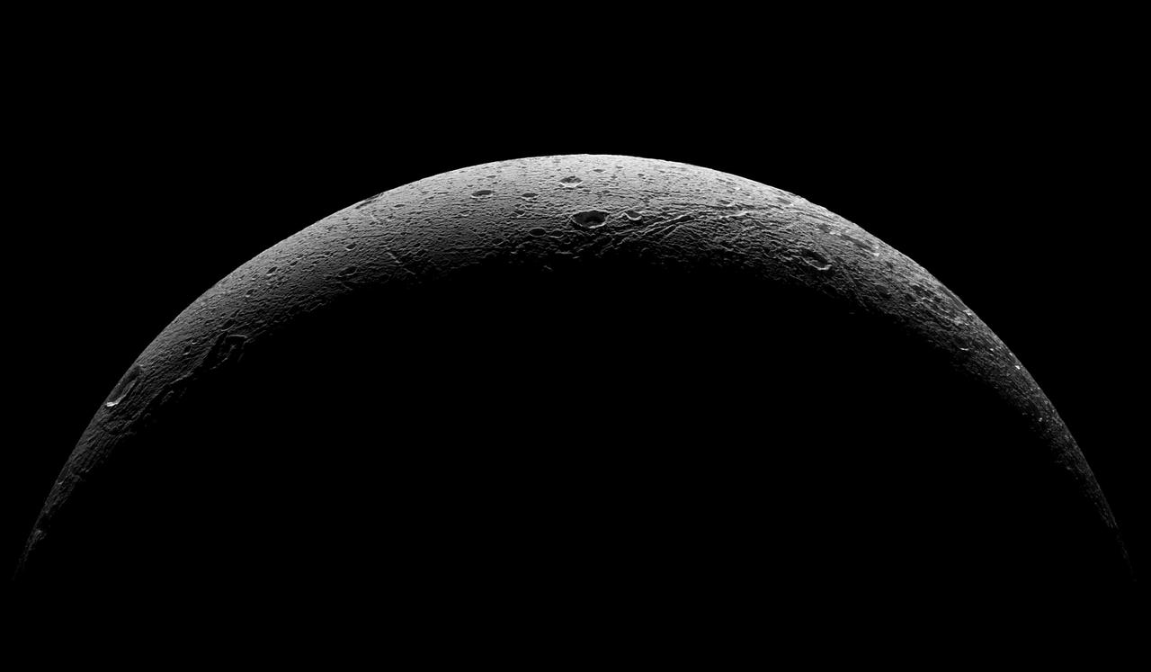
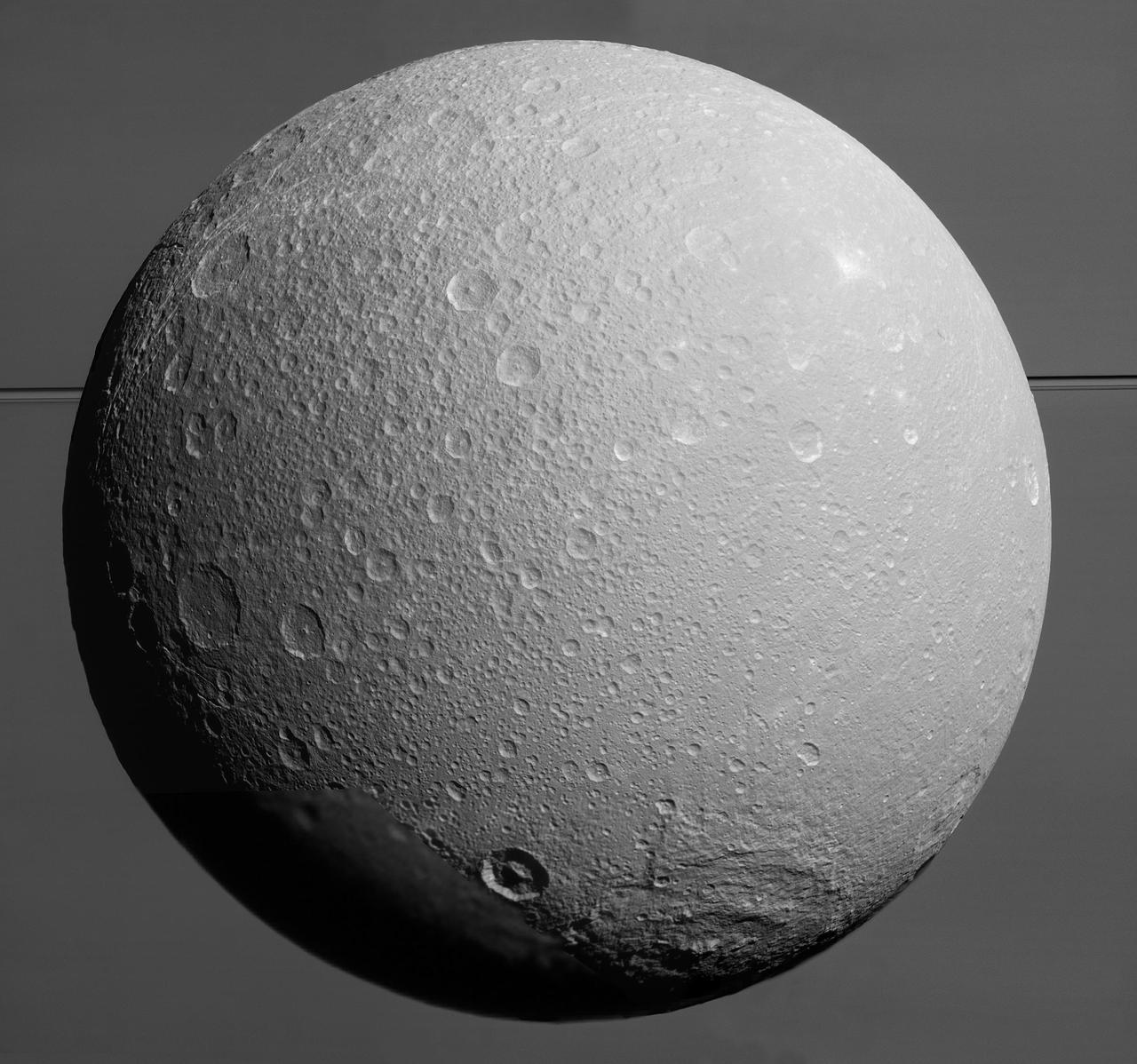
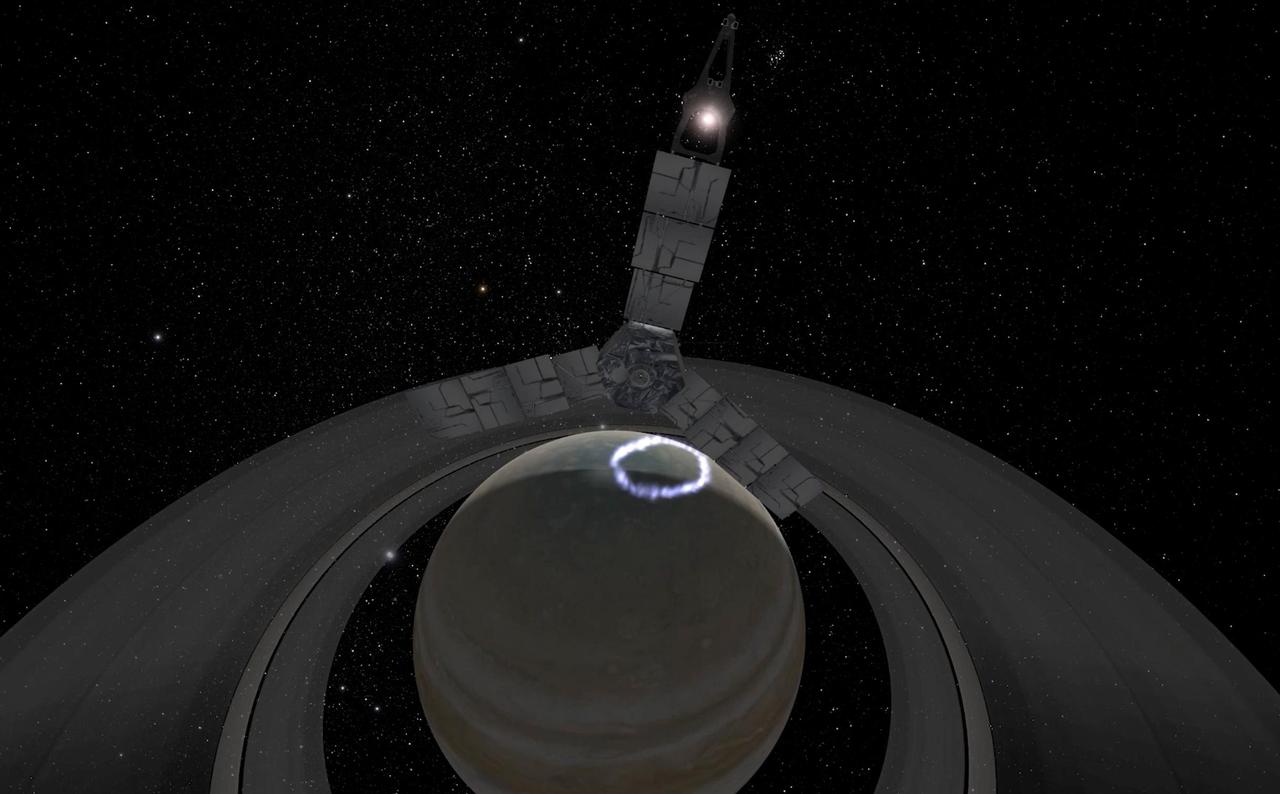
S73-16199 (December 1972) --- A close-up view of Apollo 17 lunar sample number 72415,0 which was brought back from the Taurus-Littrow landing site by the Apollo 17 crewmen. This sample is a brecciated dunite clast weighing a little over 32 grams (about 1.14 ounces). This sample was collected at station 2 (South Massif) during the second Apollo 17 extravehicular activity (EVA). IMPORTANT NOTE FOR CREDIT: The view was photographed by Karl Mills, Scientific Photo Arts, Berkeley, California.
View of Apollo 17 lunar rock sample no. 72415,0
ISS017-E-015059 (27 Aug. 2008) --- An overall interior view of the Zvezda Service Module photographed by an Expedition 17 crewmember on the International Space Station.
Overall view of the SM during Expedition 17
Panorama view of Apollo 17 Lunar surface photos for use in presentations to NASA management and for Outreach Education in regard to new NASA initiative for human planetary research. Photo numbers used for this panoramic include: Apollo 17 start frame AS17-136-20745 thru end frame AS17-136-20759. View is of Station 1, taken during the first Extravehicular Activity (EVA) 1.
Panorama view of Apollo 17 Lunar surface photos
Panorama view of Apollo 17 Lunar surface photos for use in presentations to NASA management and for Outreach Education in regard to new NASA initiative for human planetary research. Photo numbers used for this panoramic include: Apollo 17 start frame AS17-146-22339 thru end frame AS17-146-22363. View is of Station 7 Panorama taken during Extravehicular Activity (EVA) 3.
Panorama view of Apollo 17 Lunar surface photos
   Panorama view of Apollo 17 Lunar surface photos for use in presentations to NASA management and for Outreach Education in regard to new NASA initiative for human planetary research. Photo numbers used for this panoramic include: Apollo 17 start frame AS17-147-22572 thru end frame AS17-147-22600. View is of the Apollo Lunar Surface Experiment Package (ALSEP) Station taken during Extravehicular Activity (EVA) 1.
Panorama view of Apollo 17 Lunar surface photos
Panorama view of Apollo 17 Lunar surface photos for use in presentations to NASA management and for Outreach Education in regard to new NASA initiative for human planetary research. Photo numbers used for this panoramic include: Apollo 17 start frame AS17-138-21053 thru end frame AS17-138-21073. View is of Station 2, taken during the second Extravehicular Activity (EVA) 2.
Panorama view of Apollo 17 Lunar surface photos
S73-16198 (December 1972) --- A close-up view of Apollo 17 lunar sample number 72415,0 which was brought back from the Taurus-Littrow landing site by the Apollo 17 crewmen. This sample is a brecciated dunite clast weighing a little over 32 grams (about 1.14 ounces). This sample was collected at station 2 (South Massif) during the second Apollo 17 extravehicular activity (EVA).
View of Apollo 17 lunar rock sample no. 72415,0
AS17-134-20435 (10 Dec. 1972) --- Wide-angle view of the Apollo 17 Taurus-Littrow lunar landing site. To the left in the background is the Lunar Module. To the right in the background is the Lunar Roving vehicle. An Apollo 17 crewmember is photographed between the two points. The shadow of the astronaut taking the photograph can be seen in the right foreground.
Wide-angle view of Apollo 17 lunar landing site
AS17-148-22717 (7 Dec. 1972) --- This view of a portion of Earth was taken from the Apollo 17 spacecraft following trans-lunar insertion during the final lunar landing mission in NASA's Apollo Program. The visible land mass is the southern two-thirds of the African continent, with Madagascar at right. A portion of Antarctica is visible at bottom frame. Onboard the Apollo 17 spacecraft were astronauts Eugene A. Cernan, commander; Ronald E. Evans, command module pilot; and Harrison H. Schmitt, lunar module pilot. While astronauts Cernan and Schmitt descended in the Lunar Module (LM) "Challenger" to explore the Hadley-Apennine region of the moon, astronaut Evans remained with the Command and Service Modules (CSM) "America" in lunar orbit.
View of Africa and Madagascar from the Apollo 17 spacecraft
AS17-148-22688 (7-19 Dec. 1972) --- View of the Lunar Module from the Apollo 17 spacecraft after transposition/docking maneuvers. The white dots surrounding the Lunar Module are debris from the Saturn S-IVB stage separation.
View Lunar Module from the Apollo 17 spacecraft during transposition/docking
The second manned lunar landing mission, Apollo 12, launched from launch pad 39-A at Kennedy Space Center in Florida on November 14, 1969 via a Saturn V launch vehicle. The Saturn V vehicle was developed by the Marshall Space Flight Center (MSFC) under the direction of Dr. Wernher von Braun. Aboard Apollo 12 was a crew of three astronauts: Alan L. Bean, pilot of the Lunar Module (LM), Intrepid; Richard Gordon, pilot of the Command Module (CM), Yankee Clipper; and Spacecraft Commander Charles Conrad. The LM, Intrepid, landed astronauts Conrad and Bean on the lunar surface in what’s known as the Ocean of Storms while astronaut Richard Gordon piloted the CM, Yankee Clipper, in a parking orbit around the Moon. Lunar soil activities included the deployment of the Apollo Lunar Surface Experiments Package (ALSEP), finding the unmanned Surveyor 3 that landed on the Moon on April 19, 1967, and collecting 75 pounds (34 kilograms) of rock samples. This is the seventeenth of 25 images captured by the crew in attempt to provide a 360 degree Lunar surface scene. Apollo 12 safely returned to Earth on November 24, 1969.
Saturn Apollo Program
AS17-134-20466 (7-19 Dec. 1972) --- A close-up view of the U.S. flag deployed on the moon at the Taurus-Littrow landing site by the crewmen of the Apollo 17 lunar landing mission. The crescent Earth can be seen in the far distant background above the flag. The lunar feature in the near background is South Massif. While astronauts Eugene A. Cernan and Harrison H. Schmitt descended in the Lunar Module "Challenger" to explore the lunar surface, astronaut Ronald E. Evans remained with the Apollo 17 Command and Service Modules in lunar orbit.
Close-up view of U.S. flag deployed on Moon by Apollo 17 crew
This view of the head of the remote sensing mast on the Mars Science Laboratory mission rover, Curiosity, shows seven of the 17 cameras on the rover.
Head of Mast on Mars Rover Curiosity
AS17-137-20992 (12 Dec. 1972) --- A view looking into Shorty Crater, taken at Station 4, showing the orange soil. Astronaut Harrison H. Schmitt found the orange soil on the moon during the second Apollo 17 extravehicular activity (EVA) at the Taurus-Littrow landing site. While astronauts Eugene A. Cernan, commander, and Schmitt, lunar module pilot, descended in the Lunar Module (LM) "Challenger" to explore the Taurus-Littrow region of the moon, astronaut Ronald E. Evans, command module pilot, remained with the Command and Service Modules (CSM) "America" in lunar orbit.
Wide-angle view of Station 4 during Apollo 17 second EVA
NASA Mars Exploration Rover Spirit used its navigation camera to take the images that have been combined into this stereo, 180-degree view of the rover surroundings on Feb. 17, 2009. 3D glasses are necessary to view this image.
Spirit View Beside Home Plate on Sol 1823 Stereo
In a shallow depression called Yellowknife Bay, the NASA Mars rover Curiosity drove to an edge of the feature to record this view of the ledge at the margin and a view across the bay during the 130th Martian day, or sol, Dec. 17, 2012.
At Edge of Yellowknife Bay, Sol 130
AS17-145-22183 (7-19 Dec. 1972) --- One of the Apollo 17 crew took this picture of a large boulder field during lunar surface extravehicular activity (EVA) at the Taurus-Littrow landing site. This view is looking northeast. Apollo 17 was the final lunar landing mission in NASA's Apollo Program. While astronauts Eugene A. Cernan, commander, and Harrison H. Schmitt, lunar module pilot, descended in the Lunar Module (LM) "Challenger" to explore the Taurus-Littrow region of the moon, astronaut Ronald E. Evans, command module pilot, remained with the Command and Service Modules (CSM) "America" in lunar orbit.
Panoramic view of Station 5 (Camelot Crater) during Apollo 17 EVA-2
NASA Cassini spacecraft captured this high-resolution view of the cratered surface of Saturn moon Rhea as the spacecraft flew by the moon on Oct. 17, 2010.
Rhea Northern Craters
A recent NASA Hubble Space Telescope view reveals Uranus surrounded by its four major rings and by 10 of its 17 known satellites.
Hubble Finds Many Bright Clouds on Uranus
AS17-148-22718 (7-19 Dec. 1972) --- This excellent view of Saudi Arabia and the north eastern portion of the African continent was photographed by the Apollo 17 astronauts with a hand-held camera on their trans-lunar coast toward man's last lunar visit. Egypt, Sudan, Ethiopia are some of the African nations are visible. Iran, Iraq, Jordan are not so clearly visible because of cloud cover and their particular location in the picture. India is dimly visible at right of frame. The Red Sea is seen entirely in this one single frame, a rare occurrence in Apollo photography or any photography taken from manned spacecraft. The Gulf of Suez, the Dead Sea, Gulf of Aden, Persian Gulf and Gulf of Oman are also visible. This frame is one of 169 frames on film magazine NN carried aboard Apollo 17, all of which are SO368 (color) film. A 250mm lens on a 70mm Hasselblad camera recorded the image, one of 92 taken during the trans-lunar coast. Note AS17-148-22727 (also magazine NN) for an excellent full Earth picture showing the entire African continent.
View of Saudi Arabia and north eastern Africa from the Apollo 17 spacecraft
AS17-148-22727 (7 Dec. 1972) --- This view of Earth was seen by the Apollo 17 crew as they traveled toward the moon on their NASA lunar landing mission. This outstanding trans-lunar coast photograph extends from the Mediterranean Sea area to the Antarctica south polar ice cap. This is the first time the Apollo trajectory made it possible to photograph the south polar ice cap. Note the heavy cloud cover in the Southern Hemisphere. Almost the entire coastline of Africa is clearly visible. The Arabian Peninsula can be seen at the northeastern edge of Africa. The large island off the coast of Africa is the Malagasy Republic. The Asian mainland is on the horizon toward the northeast. The Apollo 17 crew consisted of astronauts Eugene A. Cernan, mission commander; Ronald E. Evans, command module pilot; and Harrison H. Schmitt, lunar module pilot. While astronauts Cernan and Schmitt descended in the Lunar Module (LM) to explore the moon, astronaut Evans remained with the Command and Service Modules (CSM) in lunar orbit.
View of the Earth seen by the Apollo 17 crew traveling toward the moon
AS17-137-20989 (12 Dec. 1972) --- A close-up view of the much-publicized orange soil which the Apollo 17 crewmen found at Station 4 (Shorty Crater) during the second Apollo 17 extravehicular activity (EVA) at the Taurus-Littrow landing site. The orange soil was first spotted by scientist-astronaut Harrison H. Schmitt. While astronauts Schmitt and Eugene A. Cernan descended in the Lunar Module (LM) "Challenger" to explore the lunar surface, astronaut Ronald E. Evans remained with the Apollo 17 Command and Service Modules (CSM) in lunar orbit. The orange soil was never seen by the crewmen of the other lunar landing missions - Apollo 11 (Sea of Tranquility); Apollo 12 (Ocean of Storms); Apollo 14 (Fra Mauro); Apollo 15 (Hadley-Apennines); and Apollo 16 (Descartes).
View of the orange soil which Apollo 17 crewmen found at Station 4 during EVA
NASA Dawn spacecraft obtained these images with its framing camera on Aug.17 and Sept.17, 2011. The left hand image shows scarps, mostly near the bottom. The right hand image is a close up, higher resolution view of a large part of the raised mound.
Two Different Resolution Images of Vesta South Polar Region
AS17-137-20990 (12 Dec. 1972) --- A view of the area at Station 4 (Shorty Crater) showing the now highly-publicized orange soil which the Apollo 17 crew members found on the moon during the second Apollo 17 extravehicular activity (EVA) at the Taurus-Littrow landing site. The tripod-like object is the gnomon and photometric chart assembly which is used as a photographic reference to establish local vertical sun angle, scale and lunar color. The gnomon is one of the Apollo lunar geology hand tools. While astronauts Eugene A. Cernan, commander, and Harrison H. Schmitt, lunar module pilot, descended in the Lunar Module (LM) "Challenger" to explore the Taurus-Littrow region of the moon, astronaut Ronald E. Evans, command module pilot, remained with the Command and Service Modules (CSM) "America" in lunar orbit. Schmitt was the crew man who first spotted the orange soil.
View of the orange soil which Apollo 17 crewmen found at Station 4 during EVA
NASA Cassini spacecraft took images of the ropy, taffy-like topography of Saturn moon Enceladus from many different angles as the spacecraft flew by on Feb. 17, 2005. 3D glasses are necessary to view this image.
Cassini Views Enceladus in Stereo
NASA Terra spacecraft acquired this image, a birdseye view of the Canary Islands wildfire, on Aug. 17, 2012. The main town of San Sebastian can be seen on the eastern shore of the island.
NASA Spacecraft Gets a Birdseye View of Canary Islands Wildfire
This view from NASA's Dawn spacecraft features Liber Crater (14 miles, 23 kilometers wide) in Ceres' northern hemisphere, at right.  Dawn took this image on June 17, 2016, from its low-altitude mapping orbit, at a distance of about 240 miles (385 kilometers) above the surface. The image resolution is 120 feet (35 meters) per pixel.  http://photojournal.jpl.nasa.gov/catalog/PIA20863
Dawn LAMO Image 143
jsc2004e20304 - Panorama view of Apollo 17 lunar surface photos for Station 5 at the Taurus-Littrow landing site taken during the second moonwalk of the mission by Apollo 17 commander Eugene Cernan and lunar module pilot Harrison (Jack) Schmitt. The panoramas were built by combining Apollo 17 images starting with frame AS17-145-22159 through end frame AS17-145-22181. The panoramic images received minimal retouching by NASA imagery specialists, including the removal of lens flares that were problematic in stitching together the individual frames and blacking out the sky to the lunar horizon. These adjustments were made based on observations of the Moon walkers who reported that there are no stars visible in the sky due to the bright lunar surface reflection of the Sun.
jsc2004e20304 - Panorama view of Apollo 17 lunar surface photos for Station 5 at the Taurus-Littrow landing site taken during the second moonwalk of the mission by Apollo 17 commander Eugene Cernan and lunar module pilot Harrison (Jack) Schmitt. The panora
jsc2004e52779 - Panorama view of Apollo 17 lunar surface photos for Station 6 taken during the third moonwalk of the mission by Apollo 17 commander Eugene Cernan and lunar module pilot Harrison (Jack) Schmitt. The panoramas were built by combining Apollo 17 images starting with frame AS17-141-21575 through end frame AS17-141-21603. The panoramic images received minimal retouching by NASA imagery specialists, including the removal of lens flares that were problematic in stitching together the individual frames and blacking out the sky to the lunar horizon. These adjustments were made based on observations of the Moon walkers who reported that there are no stars visible in the sky due to the bright lunar surface reflection of the Sun.
jsc2004e52779 - Panorama view of Apollo 17 lunar surface photos for Station 6 taken during the third moonwalk of the mission by Apollo 17 commander Eugene Cernan and lunar module pilot Harrison (Jack) Schmitt. The panoramas were built by combining Apollo 1
KENNEDY SPACE CENTER, FLA. -  Viewed from inside the aft section of the orbiter Discovery, a worker installs the liquid oxygen feedline for the 17-inch disconnect, coming up from below. The 17-inch liquid oxygen and liquid hydrogen disconnects provide the propellant feed interface from the external tank to the orbiter main propulsion system and the three Shuttle main engines.
KENNEDY SPACE CENTER, FLA. - Viewed from inside the aft section of the orbiter Discovery, a worker installs the liquid oxygen feedline for the 17-inch disconnect, coming up from below. The 17-inch liquid oxygen and liquid hydrogen disconnects provide the propellant feed interface from the external tank to the orbiter main propulsion system and the three Shuttle main engines.
This view from NASA Dawn spacecraft, taken on Oct. 17, 2015, from an altitude of 915 miles 1,470 kilometers, shows southern mid-latitudes on Ceres, including a relatively fresh crater near upper left.  http://photojournal.jpl.nasa.gov/catalog/PIA20137
Dawn HAMO Image 74
This view from Ceres' northern hemisphere shows parts of Datan Crater (at left) and Geshtin Crater (at right).  NASA's Dawn spacecraft took this image on June 17, 2016, from its low-altitude mapping orbit, at a distance of about 240 miles (385 kilometers) above the surface. The image resolution is 120 feet (35 meters) per pixel.  http://photojournal.jpl.nasa.gov/catalog/PIA20860
Dawn LAMO Image 140
This view from NASA's Dawn spacecraft shows the rim of Ernutet Crater (32 miles, 52 kilometers in diameter) on Ceres.  NASA's Dawn spacecraft took this image on June 17, 2016, from its low-altitude mapping orbit, at a distance of about 240 miles (385 kilometers) above the surface. The image resolution is 120 feet (35 meters) per pixel.  http://photojournal.jpl.nasa.gov/catalog/PIA20862
Dawn LAMO Image 142
NASA Cassini spacecraft captured this parting view showing the rough and icy crescent of Saturn moon Dione following the spacecraft last close flyby of the moon on Aug. 17, 2015.  Cassini obtained a similar crescent view in 2005 (see PIA07745). The earlier view has an image scale about four times higher, but does not show the moon's full crescent as this view does.  Five visible light (clear spectral filter), narrow-angle camera images were combined to create this mosaic view. The scene is an orthographic projection centered on terrain at 0.4 degrees north latitude, 30.6 degrees west longitude on Dione. An orthographic view is most like the view seen by a distant observer looking through a telescope.  The view was acquired at distances ranging from approximately 37,000 miles (59,000 kilometers) to 47,000 miles (75,000 kilometers) from Dione and at a sun-Dione-spacecraft, or phase, angle of 145 degrees. Image scale is about 1,300 feet (400 meters) per pixel.  North on Dione is up and rotated 34 degrees to the right.  http://photojournal.jpl.nasa.gov/catalog/PIA19649
Departing Dione
View of the second level in the Vertical Processing Area, SSMEPF, August 17, 1998
KSC-20120208-PH-UK_OPF3_Figure-A-12
Aerial view of OPF-3 construction, March 17, 1987
KSC-20120208-PH-UK_OPF3_Figure-A-1
View of the Horizontal Processing Area, SSMEPF, August 17, 1998
KSC-20120208-PH-UK_OPF3_Figure-A-11
NASA Mars Exploration Rover Opportunity used its navigation camera to record this view in the eastward driving direction after completing a drive on July 17, 2011, that took the rover total driving distance on Mars beyond 20 miles.
Drive Direction Image by Opportunity After Surpassing 20 Miles
This view from NASA Dawn spacecraft shows high northern latitudes on Ceres. Dawn acquired the image on Oct. 17, 2015, from an altitude of 915 miles 1,470 kilometers. It has a resolution of 450 feet 140 meters per pixel.  http://photojournal.jpl.nasa.gov/catalog/PIA20138
Dawn HAMO Image 75
As it sped away from a relatively distant encounter with Titan on Feb. 17, 2017, NASA's Cassini spacecraft captured this mosaic view of the moon's northern lakes and seas.   Cassini's viewing angle over Kraken Mare and Ligeia Mare was better during this flyby than previous encounters, providing increased contrast for viewing these seas. Because the spacecraft is peering through less of Titan's haze toward Kraken and Ligeia, more details on their shorelines are visible, compared to earlier maps.  This was one of several "non-targeted" Cassini Titan flybys in 2017 that allow the mission to image the moon's north polar region and track clouds there. ("Non-targeted" means Cassini did not have to use any rocket-thruster firings to steer itself toward the flyby.)  Several prominent cloud streaks are visible at mid-latitudes between 45 and 55 degrees north latitude, on the right side of the image. Smaller bright clouds are seen just above the sea called Punga Mare (roughly at center). Scientists are seeing increasing cloud activity in Titan's north polar region as the seasons continue to change from spring to summer there, though not as much as predicted by models of Titan's atmosphere.  The images in this mosaic were taken with the Cassini spacecraft narrow-angle camera using a spectral filter sensitive to wavelengths of near-infrared light centered at 938 nanometers.  The view was obtained at a distance of approximately 150,700 miles (242,500 kilometers) from Titan. Image scale is about 1.6 miles (2.6 kilometers) per pixel. The view is an orthographic projection centered on 68 degrees north latitude, 225 degrees west longitude. An orthographic view is most like the view seen by a distant observer looking through a telescope.  http://photojournal.jpl.nasa.gov/catalog/PIA21434
Titan: Kraken and Ligeia In Sharper Focus
Relatively young craters, with sharp crater rims and streaks of bright material, are the focus of this view of Ceres from NASA's Dawn spacecraft. The large, ancient and quite degraded crater Fluusa is seen at top center. The younger craters are Kupalo, at lower right, and Juling, to its left.  Dawn took this image on Oct. 17, 2016, from its second extended-mission science orbit (XMO2), at a distance of about 920 miles (1,480 kilometers) above the surface. The image resolution is about 460 feet (140 meters) per pxel.  http://photojournal.jpl.nasa.gov/catalog/PIA21223
Dawn XMO2 Image 3
iss054e022260 (Jan. 17, 2018) --- View inside the crew quarters where astronauts sleep on the International Space Station.
View inside the crew quarters
iss050e016760 (12/17/2016) --- View of Aquapad Containment Boxes. Photo was taken during Expedition 50.
Aquapad Containment Boxes
Juno's 53-day orbit has presented the opportunity to observe Jupiter's dark side. This animation is an artist's rendition of Juno's inbound -- over Jupiter's north pole -- approach to Perijove 17 (which occurred on Dec. 21, 2018). During the flyby the SRU obtained the closest view of Jupiter's aurora with a visible light imager to date.  Animation available at https://photojournal.jpl.nasa.gov/catalog/PIA22962
Juno's Perijove 17 (Artist's Concept)
Terrain shown in this view from Ceres lies within the large, southern hemisphere impact basin named Zadeni (80 miles, 129 kilometers across).  NASA's Dawn spacecraft took this image on June 17, 2016, from its low-altitude mapping orbit, at a distance of about 240 miles (385 kilometers) above the surface. The image resolution is 120 feet (35 meters) per pixel.  http://photojournal.jpl.nasa.gov/catalog/PIA20859
Dawn LAMO Image 139
This view from NASA Cassini spacecraft looks toward Saturn icy moon Dione, with giant Saturn and its rings in the background, just prior to the mission final close approach to the moon on August 17, 2015.  At lower right is the large, multi-ringed impact basin named Evander, which is about 220 miles (350 kilometers) wide. The canyons of Padua Chasma, features that form part of Dione's bright, wispy terrain, reach into the darkness at left.  Imaging scientists combined nine visible light (clear spectral filter) images to create this mosaic view: eight from the narrow-angle camera and one from the wide-angle camera, which fills in an area at lower left. The scene is an orthographic projection centered on terrain at 0.2 degrees north latitude, 179 degrees west longitude on Dione. An orthographic view is most like the view seen by a distant observer looking through a telescope. North on Dione is up.  The view was acquired at distances ranging from approximately 106,000 miles (170,000 kilometers) to 39,000 miles (63,000 kilometers) from Dione and at a sun-Dione-spacecraft, or phase, angle of 35 degrees. Image scale is about 1,500 feet (450 meters) per pixel.  http://photojournal.jpl.nasa.gov/catalog/PIA19650
Imminent Approach to Dione
Russian Return EVA16, 17 Part 207 pt2
View of FE Wheelock during EVA-17
S73-16007 (December 1972) --- A "mug shot" of Apollo 17 lunar sample no. 72255 which was brought back from the lunar surface by the final team of Apollo astronauts. The rock weighs 461.2 grams and measures 2.5 x 9 x 10.5 centimeters. The light grey breccia is sub-rounded on all faces except the top and north sides.
View of Apollo 17 lunar rock sample no. 72255
3/4 rear view of SCAT-17 supersonic transport with thrust reverser installed and trailing edge flaps deflected at 30 deg.
SCAT-17 Supersonic Transport in the 40x80 foot wind tunnel at NASA Ames.
 SHELL BUCKLING KNOCKDOWN FACTOR (SBKF) PROJECT - COMPOSITE TEST ARTICLE, (CTA) 8.3 – 12/17/19 – VIEW 1 OF 12
SHELL BUCKLING KNOCKDOWN FACTOR (SBKF) PROJECT - COMPOSITE TEST ARTICLE, (CTA) 8.3 – 12/17/19
 SHELL BUCKLING KNOCKDOWN FACTOR (SBKF) PROJECT - COMPOSITE TEST ARTICLE, (CTA) 8.3 – 12/17/19 – VIEW 1 OF 12
SHELL BUCKLING KNOCKDOWN FACTOR (SBKF) PROJECT - COMPOSITE TEST ARTICLE, (CTA) 8.3 – 12/17/19
 SHELL BUCKLING KNOCKDOWN FACTOR (SBKF) PROJECT - COMPOSITE TEST ARTICLE, (CTA) 8.3 – 12/17/19 – VIEW 1 OF 12
SHELL BUCKLING KNOCKDOWN FACTOR (SBKF) PROJECT - COMPOSITE TEST ARTICLE, (CTA) 8.3 – 12/17/19
ISS017-E-019390 (11 Oct. 2008) --- A gibbous moon is visible in this view above Earth's atmosphere, photographed by an Expedition 17 crewmember on the International Space Station.
Earth Observations taken by the Expedition 17 Crew
AS17-148-22714 (7-19 Dec. 1972) --- View of the expended Saturn IVB stage before Apollo 17 transposition/docking maneuvers.
View of the expended Saturn IVB stage after transposition/docking
S72-01716 (July 1972) --- An oblique view of the Taurus-Littrow area on the lunar nearside, as photographed from the Apollo 15 spacecraft in lunar orbit. This is an enlarged view. The "X" marks the landing site of the scheduled Apollo 17 lunar landing mission. The overlay points out several features in the photograph. The coordinates of the Apollo 17 touchdown point are 30 degrees 44 minutes 58 seconds east longitude and 20 degrees 9 minutes 50 seconds north latitude.
Photograph of Apollo 17 lunar landing site location
iss034e065948 (3/11/2013) --- A view of the Biological Research In Canisters-17 - A and B actuation (BRIC-17). BRIC supports a variety of plant growth investigations which focus on the growth and development of cell cultures in microgravity. Specimens are preserved with a chemical fixative and returned to the ground for post-flight evaluation.
Biological Research In Canisters-17
STS106-375-022 (17 September 2000) --- This view of the International Space Station (ISS) was captured with a 35mm handheld camera through the Space Shuttle Atlantis' crew optical alignment system (COAS) during undocking operations. The undocking took place at 10:46 p.m. (CDT) on September 17, 2000.
Flyaround view of the ISS taken from Atlantis during STS-106
iss034e065937 (3/11/2013) --- A view of the Biological Research In Canisters-17 - A and B actuation (BRIC-17). BRIC supports a variety of plant growth investigations which focus on the growth and development of cell cultures in microgravity. Specimens are preserved with a chemical fixative and returned to the ground for post-flight evaluation.
Biological Research In Canisters-17
STS054-S-034 (17 Jan 1993) --- Closeup view of Runco as he works to install a mobile foot restraint during extravehicular activity (EVA) in Endeavour's cargo bay.  The scene was downlinked at 11:55:07:24 GMT, Jan. 17, 1993.
STS-54 EV2 Runco attaches PFR to OV-105's PLB longeron during DTO 1210 EVA
iss034e065943 (3/11/2013) --- A view of the Biological Research In Canisters-17 - A and B actuation (BRIC-17). BRIC supports a variety of plant growth investigations which focus on the growth and development of cell cultures in microgravity. Specimens are preserved with a chemical fixative and returned to the ground for post-flight evaluation.
Biological Research In Canisters-17
iss034e065939 (3/11/2013) --- A view of the Biological Research In Canisters-17 - A and B actuation (BRIC-17). BRIC supports a variety of plant growth investigations which focus on the growth and development of cell cultures in microgravity. Specimens are preserved with a chemical fixative and returned to the ground for post-flight evaluation.
Biological Research In Canisters-17
ISS030-E-050563 (17 Jan. 2012) --- This  infrared view shows the Bahamas' Long Island (left) and parts of Little and Great Exuma (right). It was photographed as part of an experiment by one of the Expedition 30 crew members aboard the International Space Station on Jan. 17, 2012.
Infrared Red (IR) Earth Observations taken by Expedition 30 crewmember
This stereo view from NASA's Curiosity Mars Rover shows the downwind side of "Namib Dune," which stands about 13 feet (4 meters) high. The image appears three-dimensional when viewed through red-blue glasses with the red lens on the left. The site is part of Bagnold Dunes, a band of dark sand dunes along the northwestern flank of Mars' Mount Sharp.  The component images stitched together into this scene were taken with Curiosity's Navigation Camera (Navcam) on Dec. 17, 2015, during the 1,196th Martian day, or sol, of the rover's work on Mars. In late 2015 and early 2016, Curiosity is conducting the first up-close studies ever made of active sand dunes anywhere but on Earth. Under the influence of Martian wind, the Bagnold Dunes are migrating up to about one yard or meter per Earth year. http://photojournal.jpl.nasa.gov/catalog/PIA20282
Downwind Side of Namib Sand Dune on Mars, Stereo
Shuttle Challenger lands on Runway 17 at Edwards at end of 51-B mission. The photo is a rear view of the shuttle landing gear touching the runway, with clouds of dirt trailing behind it. The nose gear is still in the air (071); Side view of the Challenger landing gear touching the runway (072).
Shuttle Challenger landing on Runway 17 at Edwards at end of 51-B mission
AS17-145-22287 (7-19 Dec. 1972) --- An oblique view of the large crater Copernicus on the lunar nearside, as photographed from the Apollo 17 spacecraft in lunar orbit. This view is looking generally southwest toward the crater on the horizon. The coordinates of the center of Copernicus are approximately 20 degrees west longitude and 9.5 degrees north latitude.
Oblique view of Copernicus crater
Application of blowing type boundry-layer control to the leading and trailing edge flaps of a 52 deg swept wing.  3/4 view of Aspect Ratio 2.8, taper ratio .17, 45 deg swept back wing model -3/4 front view
McDonnell F4H Model in Ames 40X80 foot Wind Tunnel.
S66-39436 (17 June 1966) --- Wide-angle view of the Manned Spacecraft Center's news center main auditorium during a Gemini-9 press conference. Photo credit:NASA
PRESS CONFERENCE - PUBLIC AFFAIRS OFFICE (PAO) - GEMINI-TITAN (GT) 9A - OVERALL VIEW - MSC
ISS009-E-25194 (26 September 2004) --- Oblique view of Hurricane Jeanne, as seen from the International Space Station at 17:50:38 GMT,  September 26, 2004.
iss009e25194
S115-E-06451 (17 Sept. 2006) --- A close-up view of International Space Station solar array panels is featured in this image photographed by a STS-115 crewmember on Space Shuttle Atlantis.
Flyaround view of the P4 Truss taken during STS-115
NASA’s 2021 class of astronaut candidates view a booster segment for Artemis II inside the Rotation, Processing and Surge Facility during a familiarization tour of facilities on Tuesday, Oct. 17, 2023, at the agency’s Kennedy Space Center in Florida.
ASCAN Visit to KSC
iss056e096990 (7/17/2018) --- View of the installation of a Space Algae culture bags in the Veggie facility. The Space Algae investigation explores the genetic basis for productivity of algae cultivated in space and whether this requires genetic adaptations or not.
Space Algae Culture Bag Installation
iss056e096983 (7/17/2018) --- View of the installation of six Space Algae culture bags in the Veggie facility. The Space Algae investigation explores the genetic basis for productivity of algae cultivated in space and whether this requires genetic adaptations or not.
Space Algae Culture Bag Installation
ISS009-E-25178 (26 September 2004) --- The Expedition 9 crew aboard the International Space Station recorded this vertical view of Hurricane Jeanne at 17:47:42 GMT, Sept 26, 2004.
iss009e25178
General view of Ames Subsonic 40x80ft wind tunnel from atop of the Moffett Naval Airship Hangar One (with construction of the Ames 12ft Pressure Wind Tunnel in forground)  July 17, 1944
ARC-1944-AFST-78
iss056e096962 (7/17/2018) --- View of the installation of six Space Algae culture bags in the Veggie facility. The Space Algae investigation explores the genetic basis for productivity of algae cultivated in space and whether this requires genetic adaptations or not.
Space Algae Culture Bag Installation
ISS010-E-24914 (17 April 2005) --- View of the interior of the Zvezda Service module from the forward section to the aft end, as photographed by one of the Expedition 10 crewmembers on the International Space Station (ISS).
Interior view of SM during Expedition 10 / Expedition 11
iss056e096982 (7/17/2018) --- View of the installation of a Space Algae culture bags in the Veggie facility. The Space Algae investigation explores the genetic basis for productivity of algae cultivated in space and whether this requires genetic adaptations or not.
Space Algae Culture Bag Installation
KENNEDY SPACE CENTER, FLA.  - This aerial view shows the Delta II launch pads at Complex 17 on Cape Canaveral Air Force Station in Florida, rimmed by the blue Atlantic Ocean in the background.  Photo credit: Cory Huston
KSC-06pd0384
NASA’s 2021 class of astronaut candidates view a booster segment for Artemis II inside the Rotation, Processing and Surge Facility during a familiarization tour of facilities on Tuesday, Oct. 17, 2023, at the agency’s Kennedy Space Center in Florida.
ASCAN Visit to KSC
NASA’s 2021 class of astronaut candidates view a booster segment for Artemis II inside the Rotation, Processing and Surge Facility during a familiarization tour of facilities on Tuesday, Oct. 17, 2023, at the agency’s Kennedy Space Center in Florida.
ASCAN Visit to KSC
ISS007-E-12866 (17 August 2003) --- This photo showing the Manicouagan Reservoir in Quebec, Canada, and a partial view of a solar array panel was taken by an Expedition 7 crewmember onboard the International Space Station (ISS).
Earth observations taken by the Expedition Seven crew
S115-E-06292 (17 Sept. 2006) --- A close-up view of a International Space Station solar array panel is featured in this image photographed by a STS-115 crewmember on Space Shuttle Atlantis.
Backaway view during STS-115
S66-25781 (16-17 March 1966) --- Closer view of the Agena Target Docking vehicle seen from the Gemini-8 spacecraft during rendezvous in space. Photo credit: NASA
GEMINI-8 - GEMINI/AGENA RENDEZVOUS - OUTER SPACE
This view from NASA's Curiosity Mars Rover shows the downwind side of "Namib Dune," which stands about 13 feet (4 meters) high. The site is part of Bagnold Dunes, a band of dark sand dunes along the northwestern flank of Mars' Mount Sharp.  The component images stitched together into this scene were taken with Curiosity's Navigation Camera (Navcam) on Dec. 17, 2015, during the 1,196th Martian day, or sol, of the rover's work on Mars. In late 2015 and early 2016, Curiosity is conducting the first up-close studies ever made of active sand dunes anywhere but on Earth. Under the influence of Martian wind, the Bagnold Dunes are migrating up to about one yard or meter per Earth year. The view spans from westward on the left to east-southeastward on the right. It is presented as a cylindrical perspective projection. http://photojournal.jpl.nasa.gov/catalog/PIA20281
Slip Face on Downwind Side of Namib Sand Dune on Mars
KENNEDY SPACE CENTER, FLA. - In the Payload Hazardous Servicing Facility, the cylindrical payload canister is lowered around Mars Exploration Rover 1 (MER-B).  Once secure inside the canister, the rover will be transported to Launch Complex 17-B, Cape Canaveral Air Force Station, for mating with the Delta rocket.  The second of twin rovers being sent to Mars, it is equipped with a robotic arm, a drilling tool, three spectrometers, and four pairs of cameras that allow it to have a human-like, 3D view of the terrain. Each rover could travel as far as 100 meters in one day to act as Mars scientists' eyes and hands, exploring an environment where humans can't yet go.  MER-B is scheduled to launch from Pad 17-B June 26 at one of two available times,  12:27:31 a.m. EDT or 1:08:45 a.m. EDT.
KENNEDY SPACE CENTER, FLA. - In the Payload Hazardous Servicing Facility, the cylindrical payload canister is lowered around Mars Exploration Rover 1 (MER-B). Once secure inside the canister, the rover will be transported to Launch Complex 17-B, Cape Canaveral Air Force Station, for mating with the Delta rocket. The second of twin rovers being sent to Mars, it is equipped with a robotic arm, a drilling tool, three spectrometers, and four pairs of cameras that allow it to have a human-like, 3D view of the terrain. Each rover could travel as far as 100 meters in one day to act as Mars scientists' eyes and hands, exploring an environment where humans can't yet go. MER-B is scheduled to launch from Pad 17-B June 26 at one of two available times, 12:27:31 a.m. EDT or 1:08:45 a.m. EDT.
KENNEDY SPACE CENTER, FLA. - In the Payload Hazardous Servicing Facility, workers maneuver the cylindrical payload canister into place around Mars Exploration Rover 1 (MER-B).  Once secure inside the canister, the rover will be transported to Launch Complex 17-B, Cape Canaveral Air Force Station, for mating with the Delta rocket.  The second of twin rovers being sent to Mars, it is equipped with a robotic arm, a drilling tool, three spectrometers, and four pairs of cameras that allow it to have a human-like, 3D view of the terrain. Each rover could travel as far as 100 meters in one day to act as Mars scientists' eyes and hands, exploring an environment where humans can't yet go.  MER-B is scheduled to launch from Pad 17-B June 26 at one of two available times,  12:27:31 a.m. EDT or 1:08:45 a.m. EDT.
KENNEDY SPACE CENTER, FLA. - In the Payload Hazardous Servicing Facility, workers maneuver the cylindrical payload canister into place around Mars Exploration Rover 1 (MER-B). Once secure inside the canister, the rover will be transported to Launch Complex 17-B, Cape Canaveral Air Force Station, for mating with the Delta rocket. The second of twin rovers being sent to Mars, it is equipped with a robotic arm, a drilling tool, three spectrometers, and four pairs of cameras that allow it to have a human-like, 3D view of the terrain. Each rover could travel as far as 100 meters in one day to act as Mars scientists' eyes and hands, exploring an environment where humans can't yet go. MER-B is scheduled to launch from Pad 17-B June 26 at one of two available times, 12:27:31 a.m. EDT or 1:08:45 a.m. EDT.
KENNEDY SPACE CENTER, FLA. - Workers in the Payload Hazardous Servicing Facility secure the lower panels of a payload canister around Mars Exploration Rover 1 (MER-B).  The rover will be transported to Launch Complex 17-B, Cape Canaveral Air Force Station, for mating with the Delta rocket.  The second of twin rovers being sent to Mars, it is equipped with a robotic arm, a drilling tool, three spectrometers, and four pairs of cameras that allow it to have a human-like, 3D view of the terrain. Each rover could travel as far as 100 meters in one day to act as Mars scientists' eyes and hands, exploring an environment where humans can't yet go.  MER-B is scheduled to launch from Pad 17-B June 26 at one of two available times,  12:27:31 a.m. EDT or 1:08:45 a.m. EDT.
KENNEDY SPACE CENTER, FLA. - Workers in the Payload Hazardous Servicing Facility secure the lower panels of a payload canister around Mars Exploration Rover 1 (MER-B). The rover will be transported to Launch Complex 17-B, Cape Canaveral Air Force Station, for mating with the Delta rocket. The second of twin rovers being sent to Mars, it is equipped with a robotic arm, a drilling tool, three spectrometers, and four pairs of cameras that allow it to have a human-like, 3D view of the terrain. Each rover could travel as far as 100 meters in one day to act as Mars scientists' eyes and hands, exploring an environment where humans can't yet go. MER-B is scheduled to launch from Pad 17-B June 26 at one of two available times, 12:27:31 a.m. EDT or 1:08:45 a.m. EDT.
KENNEDY SPACE CENTER, FLA. - In the Payload Hazardous Servicing Facility, workers secure the cylindrical payload canister to the lower panels surrounding Mars Exploration Rover 1 (MER-B).  Once secure inside the canister, the rover will be transported to Launch Complex 17-B, Cape Canaveral Air Force Station, for mating with the Delta rocket.  The second of twin rovers being sent to Mars, it is equipped with a robotic arm, a drilling tool, three spectrometers, and four pairs of cameras that allow it to have a human-like, 3D view of the terrain. Each rover could travel as far as 100 meters in one day to act as Mars scientists' eyes and hands, exploring an environment where humans can't yet go.  MER-B is scheduled to launch from Pad 17-B June 26 at one of two available times,  12:27:31 a.m. EDT or 1:08:45 a.m. EDT.
KENNEDY SPACE CENTER, FLA. - In the Payload Hazardous Servicing Facility, workers secure the cylindrical payload canister to the lower panels surrounding Mars Exploration Rover 1 (MER-B). Once secure inside the canister, the rover will be transported to Launch Complex 17-B, Cape Canaveral Air Force Station, for mating with the Delta rocket. The second of twin rovers being sent to Mars, it is equipped with a robotic arm, a drilling tool, three spectrometers, and four pairs of cameras that allow it to have a human-like, 3D view of the terrain. Each rover could travel as far as 100 meters in one day to act as Mars scientists' eyes and hands, exploring an environment where humans can't yet go. MER-B is scheduled to launch from Pad 17-B June 26 at one of two available times, 12:27:31 a.m. EDT or 1:08:45 a.m. EDT.
S73-15713 (January 1973) --- A close-up view of Apollo 17 lunar rock sample No. 76055 being studied and analyzed in the Lunar Receiving Laboratory at the Manned Spacecraft Center. This tan-gray irregular, rounded breccia was among many lunar samples brought back from the Taurus-Littrow landing site by the Apollo 17 crew. The rock measures 18 x 20 x 25 centimeters (7.09 x 7.87 x 9.84 inches) and weighs 6,389 grams (14.2554 pounds). The rock was collected from the south side of the lunar roving vehicle while the Apollo 17 astronauts were at Station 7 (base of North Massif).
LUNAR SAMPLES - APOLLO 17 - #7605500
51G-S-100 (17 June 1985) --- A low-angle 35mm tracking view of the Space Shuttle Discovery, its external tank and two solid rocket boosters speeding from the KSC launch facility to begin NASA STS 51-G.  The camera has captured the diamond shock effect associated with the launch phase or orbiter vehicles.  Inside the Discovery are seven crewmembers and a variety of payloads representing international interests.  Liftoff for 51-G occurred at 7:33:043 a.m. (EDT), June 17, 1985.
Launching of the Shuttle Discovery and the STS 51-G mission
ISS007-E-17557 (17 October 2003) --- This sweeping view of the Rocky Mountains and the western US was taken when the International Space Station (ISS) traveled over eastern Washington on October 17, 2003. The POV of the Station was looking southeast over the mountains of Idaho (foreground) and Wyoming (Yellowstone, the Tetons and the Wind River Range are just right and above the center of the image).  Great Salt Lake is in the lower right of the image.
Earth observations taken by the Expedition Seven crew
S72-01713 (July 1972) --- A vertical view of the Apollo 17 landing site in the Taurus-Littrow area of the lunar nearside, with an overlay showing the Lunar Roving Vehicle traverse proposed for the second extravehicular activity. The scale at the bottom is measured in kilometers. One kilometer equals 0.6214 statute miles. The coordinates of the Apollo 17 touchdown point are 30 degrees 44 minutes 58 seconds east longitude and 20 degrees 9 minutes 50 seconds north latitude. This photograph was taken from lunar orbit on an earlier Apollo mission.
S72-01713
AS13-59-8562 (17 April 1970) --- This view of the Apollo 13 Lunar Module (LM) was photographed from the Command Module (CM) just after the LM had been jettisoned.  The jettisoning occurred a few minutes before 11 a.m. (CST), April 17, 1970, just over an hour prior to splashdown of the CM in the south Pacific Ocean.  The apparent explosion of oxygen tank number two in the Apollo 13 Service Module (SM) caused the Apollo 13 crew members to rely on the LM as a "lifeboat".
View of damaged Apollo 13 Service Module from the Lunar/Command Modules
ISS004-E-10119 (17 April 2002) --- The Space Shuttle Atlantis flies over Lake Powell and Utah landscape not long after its separation from the International Space Station (ISS).  One of the  Expedition Four crew members on board the orbital outpost used a digital still camera to record this view on April 17, 2002.
STS-110 Shuttle Atlantis separates from the ISS following undocking, Expedition Four
ISS020-E-040494 (17 Sept. 2009) --- A close-up view of a portion of the unpiloted Japanese H-II Transfer Vehicle (HTV) as it arrives at the International Space Station. NASA astronaut Nicole Stott, Canadian Space Agency astronaut Robert Thirsk and European Space Agency astronaut Frank De Winne, all Expedition 20 flight engineers, used the station’s robotic arm to grab the cargo craft and attach it to the Earth-facing port of the Harmony node. The attachment was completed at 5:26 (CDT) on Sept. 17, 2009.
H-II Transfer Vehicle (HTV)
S72-01711 (July 1972) --- A vertical view of the Apollo 17 landing site in the Taurus-Littrow area of the lunar nearside, with an overlay showing the Lunar Roving Vehicle traverse proposed for the first extravehicular activity. The scale at the bottom is measured in kilometers. One kilometer equals 0.6214 statute mile. The coordinates of the Apollo 17 touchdown point are 30 degrees 44 minutes 58 seconds east longitude and 20 degrees 9 minutes 50 seconds north latitude. This photograph was taken from lunar orbit on an earlier Apollo mission.
S72-01711
ISS045E108823 (11/17/2015) --- Sunrise as viewed from the International Space Station Nov. 17, 2015. Framing the brilliant edge of sun is the Soyuz TMA-17M (front) which brought NASA astronaut Kjell Lindgren, JAXA astronaut Kimiya Yui and Russian cosmonaut Oleg Kononenko to the station and the ISS Progress 60 (back) cargo craft which arrived back on July 5 with supplies, equipment & experiments.
iss045e108823
STS106-346-008 (17 Sept. 2000) --- This close-up external view of the Androgynous Peripheral Attachment System (APAS) of Pressurized Mating Adapter 2 (PMA2) was taken from the space shuttle Atlantis during undocking with the International Space Station. Visible are the APAS petals, hatch and target, as well as the forward endcone of Unity node on the ISS. The undocking took place on Sept. 17, 2000 at 10:46 p.m. (CDT).
View of the forward plane (+XA) of the PMA2
S72-01712 (July 1972) --- A vertical view of the Apollo 17 landing site in the Taurus-Littrow area of the lunar nearside, with an overlay showing the Lunar Roving Vehicle traverse proposed for the third extravehicular activity. The scale at the bottom is measured in kilometers. One kilometer equals 0.6214 statute miles. The coordinates of the Apollo 17 touchdown point are 30 degrees 44 minutes 58 seconds east longitude and 20 degrees 9 minutes 50 seconds north latitude. This photograph was taken from lunar orbit on an earlier Apollo mission.
S72-01712