Eclipse Images of Io 3 views
3-D View of Mars Particle
Front 3/4 view of the Avrocar mounted on variable height struts in the Ames 40x80 foot wind tunnel, without tail.
Front 3/4 view of the Avrocar.
Front 3/4 view of the Avrocar mounted on  variable height struts in the Ames 40x80 foot wind tunnel, without tail.
Front 3/4 view of the Avrocar.
A 3-D View of Saturn Clouds and Hazes
One View, Two Craters 3-D
Overhead view of Bell XV-3 Convertiplane. First tilt rotor tested in the 40 x 80 wind tunnel.  Transition aerodynamics studied; shown in hover mode.
Overhead view of Bell XV-3 Convertiplane
Laser Provides First 3-D View of Mars North Pole
Proposed Mars Polar Lander Landing Site Perspective View 3
Maat Mons is displayed in this 3-dimensional perspective view of the surface of Venus taken by NASA Magellan. The viewpoint is located north of Maat Mons.  http://photojournal.jpl.nasa.gov/catalog/PIA00254
Venus - 3-D Perspective View of Maat Mons
NASA Mars Exploration Rover Spirit looked up at the Columbia Hills from its location on the 265th martian day, or sol, of its mission Sept. 30, 2004 and captured this 3-D view. 3D glasses are necessary to view this image.
Spirit View of Columbia Hills 3-D
This 3-D cylindrical-perspective mosaic was created from navigation camera images that NASA Mars Exploration Rover Spirit captured on on sol 123. 3D glasses are necessary to view this image.
Spirit View on Sol 123 3-D
This 3-D cylindrical-perspective mosaic was created from navigation camera images that NASA Mars Exploration Rover Spirit captured on on sol 110. 3D glasses are necessary to view this image.
Spirit View on Sol 110 in 3-D
This 3-D cylindrical-perspective mosaic was created from navigation camera images that NASA Mars Exploration Rover Spirit captured on on sol 93. 3D glasses are necessary to view this image.
Spirit View on Sol 93 3-D
This 3-D cylindrical-perspective mosaic was created from navigation camera images that NASA Mars Exploration Rover Spirit captured on on sol 107. 3D glasses are necessary to view this image.
Spirit View on Sol 107 in 3-D
This 3-D cylindrical-perspective mosaic was created from navigation camera images that NASA Mars Exploration Rover Spirit captured on on sol 101. 3D glasses are necessary to view this image.
Spirit View on Sol 101 3-D
This 3-D cylindrical-perspective mosaic was created from navigation camera images that NASA Mars Exploration Rover Spirit captured on on sol 109. 3D glasses are necessary to view this image.
Opportunity View on Sol 109 3-D
This image is a 3-D view in front of NASA Curiosity rover captured by the rover front left Hazard-Avoidance camera. The image is cropped but part of Mount Sharp is still visible rising above the terrain.
3-D View from the Front of Curiosity
This image is a 3-D view behind NASA Curiosity rover. The anaglyph was made from a stereo pair of Hazard-Avoidance Cameras on the rear of the rover. It has been cropped.
3-D View from Behind Curiosity
This 3-D cylindrical-perspective mosaic was created from navigation camera images that NASA Mars Exploration Rover Spirit captured on on sol 100. 3D glasses are necessary to view this image.
Spirit View on Sol 100 3-D
This 3-D cylindrical-perspective mosaic was created from navigation camera images that NASA Mars Exploration Rover Spirit captured on on sol 124. 3D glasses are necessary to view this image.
Spirit View on Sol 124 3-D
SL3-121-2367 (July-September 1973) --- Skylab 3 Earth view of Greece, Albania, Athens and Peloponnesos. Photo credit: NASA
Skylab 3,Earth view,Greece
SL3-122-2620 (July-September 1973) --- Skylab 3 Earth view of the Nile Delta, Egypt and Suez Canal. Photo credit: NASA
Skylab 3,Earth view,Egypt
SL3-122-2621 (July-September 1973) --- Skylab 3 Earth view of the Dead Sea, Israel, Jordan River and Sea of Galilee. Photo credit: NASA
Skylab 3,Earth view,Isreal
SL3-122-2558 (July-September 1973) --- Skylab 3 Earth view of southwest Turkey, Aegean Sea, Rhodes, Lesbos and Samos. Photo credit: NASA
Skylab 3,Earth view,Turkey
This 3-D view of the calibration target for the MAHLI camera aboard NASA Mars rover Curiosity was assembled from two images taken by that camera during the 34th Martian day. The camera is on the turret of tools at the end of Curiosity robotic arm.
3-D View of MAHLI Calibration Target
This 3-D view was created from data acquired Feb. 4, 2013 by NASA Terra spacecraft showing a massive wildfire which damaged Australia largest optical astronomy facility, the Siding Spring Observatory.
NASA Spacecraft Captures 3-D View of Massive Australian Wildfire
This image is a 3-D view in front of NASA Curiosity rover. Mount Sharp is visible rising above the terrain, though in one eye a box on the rover holding the drill bits obscures the view.
3-D View from the Front of Curiosity
ISS01-E-5048 (8 December 2000) ---This digital still camera's view was taken in the International Space Station's Primary Mating Adapter-3 (PMA-3) looking into the tunnel that leads to the Unity node.
View in PMA-3 looking into connecting tunnel
SL3-122-2581 (July-September 1973) --- Skylab 3 Earth view of the Grand Canyon, Lake Mead and Kaibab. Photo credit: NASA
Skylab 3,Earth view,Grand Canyon
SL3-115-1917 (July-September 1973) --- Skylab 3 Earth view of the United Arab Republic (UAR), Nile Delta, Cairo, Suez Canal, Sinai and Dead Sea. Photo credit: NASA
Skylab 3,Earth view,Middle East
S65-18752 (23 March 1965) --- View of a cloudy part of Earth as seen from the Gemini-3 spacecraft while in orbit.
GEMINI-TITAN (GT)-3 - EARTH - SKY VIEW - MADAGASCAR (MALAGASY)
SL3-115-1924 (July-September 1973) --- Skylab 3 Earth view of Israel, Jordan, Lebanon, Syria, Iraq and the Dead Sea. Photo credit: NASA
Skylab 3,Earth view,Isreal,Jordan,Lebanon,Syria,Iraq
SL3-121-2410 (July-September 1973) --- Skylab 3 Earth view of Washington, British Columbia, Vancouver Island and Puget Sound. Photo credit: NASA
Skylab 3,Earth view,Washington,British Columbia,Vancouver Island
S65-21881 (1965) --- Overall view of the Gemini-Titan 3 on Launch Pad 19, with erector lowered. The GT-3 liftoff was at 9:24 a.m. (EST) on March 23, 1965. A photographer stands at bottom of launch pad with a movie camera.
GEMINI-TITAN (GT)-3 - ON PAD (OVERALL VIEW) - CAPE
This frame from a video shows the bright spots in Occator crater on dwarf planet Ceres, generated from data from NASA Dawn spacecraft.  The global view uses data collected by NASA's Dawn mission in April and May 2015.  The highest-resolution parts of the map have a resolution of 1,600 feet (480 meters) per pixel.  The second portion of the video shows the bright spots in Occator crater, which is about 60 miles (90 kilometers) across and 2 miles (4 kilometers) deep. Vertical relief has been exaggerated by a factor of five. Exaggerating the relief helps scientists understand and visualize the topography more easily, and highlights features that are sometimes subtle.  The third portion of the video shows a mountain about 4 miles (6 kilometers) high, which is roughly the elevation of Mount McKinley in Alaska's Denali National Park. Vertical relief has been exaggerated by a factor of five. Exaggerating the relief helps scientists understand and visualize the topography much more easily, and highlights features that are sometimes subtle.  The fourth section of the video shows the global view from the first section in 3-D view. A pair of 3-D glasses reveals striking detail in the topography of the dwarf planet.   http://photojournal.jpl.nasa.gov/catalog/PIA19619
Ceres Animations: Global View, Occator, Mountain, 3-D View
SL3-110-1430 (August 1973) --- View inside the personal hygiene locker of a Skylab 3 astronaut, which contains his toothbrush, battery operated razor, toothpaste and hand cream. Photo credit: NASA
View inside personal hygiene locker of Skylab 3 astronauts
S65-21520 (23 March 1965) --- Distant view showing the successful launching of the first manned Gemini flight. The Gemini-Titan 3 (GT-3) lifted off Pad 19, at the Kennedy Space Center (KSC) at 9:24 a.m. (EST), March 23, 1965. The Gemini-3 spacecraft "Molly Brown" carried astronauts Virgil I. Grissom, command pilot, and John W. Young, pilot, on three successful orbits of Earth.
LIFTOFF - GEMINI-TITAN (GT)-3 - DISTANT VIEW - CAPE
SL3-114-1625 (July-September 1973) --- An excellent view of the expended S-IVB second stage of the Skylab 3/Saturn 1B space vehicle is seen in this photograph taken from the Skylab 3 Command and Service Module (CSM) in Earth orbit. The land mass below is Italy and France, with part of the Mediterranean Sea visible. This photograph was taken with a handheld 70mm Hasselblad camera using a 100mm lens, and medium speed Ektachrome film. Photo credit: NASA
View of the expended S-IVB second stage of Skylab 3 space vehicle
The second manned lunar landing mission, Apollo 12 launched from launch pad 39-A at Kennedy Space Center in Florida on November 14, 1969 via a Saturn V launch vehicle. The Saturn V vehicle was developed by the Marshall Space Flight Center (MSFC) under the direction of Dr. Wernher von Braun. Aboard Apollo 12 was a crew of three astronauts: Alan L. Bean, pilot of the Lunar Module (LM), Intrepid; Richard Gordon, pilot of the Command Module (CM), Yankee Clipper; and Spacecraft Commander Charles Conrad. The LM, Intrepid, landed astronauts Conrad and Bean on the lunar surface in what’s known as the Ocean of Storms while astronaut Richard Gordon piloted the CM, Yankee Clipper, in a parking orbit around the Moon. Lunar soil activities included the deployment of the Apollo Lunar Surface Experiments Package (ALSEP), finding the unmanned Surveyor 3 that landed on the Moon on April 19, 1967, and collecting 75 pounds (34 kilograms) of rock samples. This is the third of 25 images captured by the crew in attempt to provide a 360 degree Lunar surface scene. Apollo 12 safely returned to Earth on November 24, 1969.
Saturn Apollo Program
AS10-27-3907 (18-26 May 1969) --- Apollo 10 westward view across Apollo Landing Site 3 in the Central Bay. Apollo Landing Site 3 is in the middle distance at the left margin of the pronounced ridge in the left half of the photograph. Bruce, the prominent crater, near the bottom of the scene, is about 6 kilometers (3.7 statute miles) in diameter. Topographic features on the surface of the Central Bay are accentuated by the low sun angle. Sun angles range from near 6 degrees at the bottom of the photograph to less than one degree at the top.
Apollo 10 view across Apollo Landing Site 3 in the Central Bay
S61-00220 (20 April 1961) --- Close-up view of astronaut Alan B. Shepard Jr. in his pressure suit, with helmet opened, for the Mercury-Redstone 3 (MR-3) flight, the first American manned spaceflight. Photo credit: NASA or National Aeronautics and Space Administration
Closeup View - Astronaut Alan Shepard - Pressure Suit - Mercury-Redstone ( MR)-3 Flight
S61-02775 (5 May 1961) --- Close-up view of astronaut Alan B. Shepard Jr. in his pressure suit, with helmet opened, for the Mercury-Redstone 3 (MR-3) flight, the first American manned spaceflight. Photo credit: NASA or National Aeronautics and Space Administration
CLOSEUP VIEW - ASTRONAUT SHEPARD, ALAN - PRESSURE SUIT - MERCURY-REDSTONE (MR)-3 - CAPE
This 3-D stereo anaglyph image was taken by NASA Mars Exploration Rover Spirit. 3D glasses are necessary to view this image.
Approaching Rock Target No. 1
View of the Lunar Module (LM) 3 and Service Module (SM) LM Adapter. Film magazine was A,film type was SO-368 Ektachrome with 0.460 - 0.710 micrometers film / filter transmittance response and haze filter, 80mm lens.
Apollo 9 Mission image - View of the Lunar Module (LM) 3 and Service Module (SM) LM Adapter
NASA Curiosity Mars rover and its tracks are visible in this view combining information from three observations by the HiRISE camera on NASA Mars Reconnaissance Orbiter. You need 3-D glasses to view this image.
Stereo View of Curiosity and Rover Tracks at the Kimberley, April 2014
This is the 3-D version of NASA Mars Exploration Rover Opportunity view on its 56th sol on Mars, before it left Eagle Crater. 3D glasses are necessary to view this image.
A Well-Traveled Eagle Crater
This 3-D cylindrical-perspective mosaic taken by the navigation camera on NASA Mars Exploration Rover Spirit on sol 82 shows the view south of the large crater dubbed Bonneville. 3D glasses are necessary to view this image.
What Lies Ahead 3-D
NASA Curiosity Mars rover recorded this stereo view of various rock types at waypoint called the Kimberley shortly after arriving at the location on April 2, 2014. You need 3-D glasses to view this image.
Curiosity View From Arrival Point at The Kimberley Waypoint Stereo
NASA Mars Exploration Rover Spirit used its navigation camera to take the images assembled into this stereo, 120-degree view southward after a short drive on February 3, 2009. 3D glasses are necessary to view this image.
Spirit Beside Home Plate, Sol 1809 Stereo
This is a 3-D version of the first 360-degree view from NASA Mars Exploration Rover Opportunity position outside Eagle Crater. 3D glasses are necessary to view this image.
Looking Back at Eagle Crater3-D
This stereo view from NASA Mars Exploration Rover Opportunity looks upward at Knudsen Ridge on the southern edge of Marathon Valley from inside the valley. You need 3-D glasses to view this image.
Steep Knudsen Ridge Along Marathon Valley on Mars Stereo
This is a three-dimensional perspective view of Long Valley, California by the Spaceborne Imaging Radar-C/X-band Synthetic Aperture Radar on board the space shuttle Endeavour. This view was constructed by overlaying a color composite SIR-C image on a digital elevation map. The digital elevation map was produced using radar interferometry, a process by which radar data are acquired on different passes of the space shuttle and, which then, are compared to obtain elevation information. The data were acquired on April 13, 1994 and on October 3, 1994, during the first and second flights of the SIR-C/X-SAR radar instrument. The color composite radar image was produced by assigning red to the C-band (horizontally transmitted and vertically received) polarization; green to the C-band (vertically transmitted and received) polarization; and blue to the ratio of the two data sets. Blue areas in the image are smooth and yellow areas are rock outcrops with varying amounts of snow and vegetation. The view is looking north along the northeastern edge of the Long Valley caldera, a volcanic collapse feature created 750,000 years ago and the site of continued subsurface activity. Crowley Lake is off the image to the left.  http://photojournal.jpl.nasa.gov/catalog/PIA01757
Space Radar Image of Long Valley, California - 3-D view
Alabama House Minority Leader Anthony Daniels, (Left), and Auburn University President, Dr. Stephen Leahy, were part of the Leadership Alabama group that viewed the SLS Liquid Hydrogen test stand at Marshall Space Flight Center on 3/7/19.
Leadership Alabama members view SLS test stand 4693 on 3/7/19
S73-34553 (25 Sept. 1973) --- Skylab flight directors (foreground) and flight controllers (background) view the large screen in the Mission Operations Control Room (MOCR) in the Mission Control Center (MCC) at JSC during recovery operations of the second manned Skylab mission. From left to right in the foreground are flight directors Charles R. Lewis, Donald R. Puffy, Phillip Shaffer and Neil B. Hutchinson. The Skylab 3 crewmen were preparing to egress the spacecraft aboard the USS New Orleans. Television cameras aboard the New Orleans recorded post-recovery activity. Photo credit: NASA
Mission Control Center (MCC) View - Skylab (SL)-3 Recovery - JSC
SL3-114-1760 (25 Sept. 1973) --? An excellent view of the three main ring sail parachutes of the Skylab 3 command module as they unfurl during descent to a successful splashdown in the Pacific Ocean. This picture was taken by a hand-held 70mm Hasselblad camera, looking up through a window of the command module. These parachutes open at approximately 10,000 feet altitude. Aboard the CM were astronauts Alan L. Bean, Owen K. Garriott and Jack R. Lousma, who had just completed a 59-day visit to the Skylab space station in Earth orbit. Photo credit: NASA
View of the parachutes of Skylab 3 command module during splashdown
This 3-D perspective view looking north over Death Valley, California, was produced by draping ASTER nighttime thermal infrared data over topographic data from the US Geological Survey. The ASTER data were acquired April 7, 2000 with the multi-spectral thermal infrared channels, and cover an area of 60 by 80 km (37 by 50 miles). Bands 13, 12, and 10 are displayed in red, green and blue respectively. The data have been computer enhanced to exaggerate the color variations that highlight differences in types of surface materials. Salt deposits on the floor of Death Valley appear in shades of yellow, green, purple, and pink, indicating presence of carbonate, sulfate, and chloride minerals. The Panamint Mtns. to the west, and the Black Mtns. to the east, are made up of sedimentary limestones, sandstones, shales, and metamorphic rocks. The bright red areas are dominated by the mineral quartz, such as is found in sandstones; green areas are limestones. In the lower center part of the image is Badwater, the lowest point in North America.  http://photojournal.jpl.nasa.gov/catalog/PIA02663
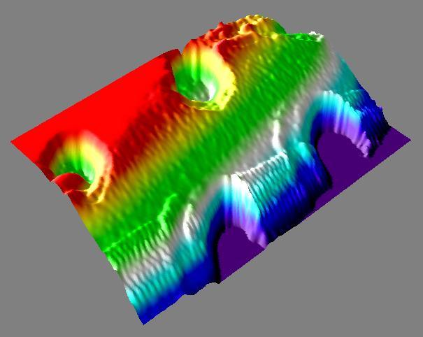
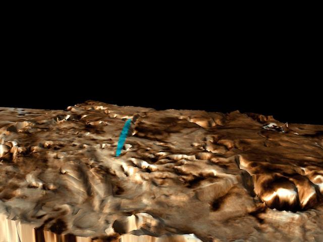
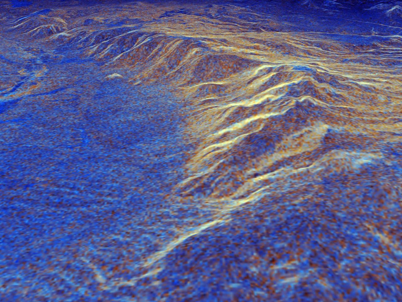
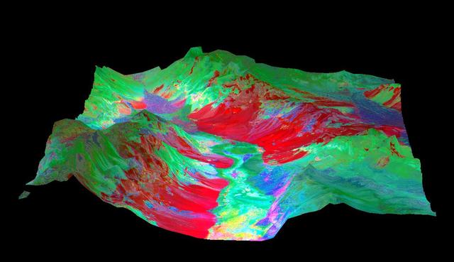
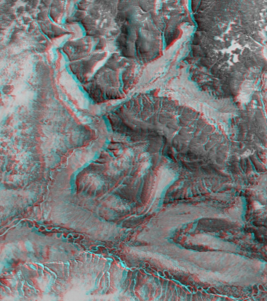
3-D View of Death Valley, California
This image taken by the microscopic imager on NASA Mars Exploration Rover Spirit shows the powdery soil of Mars in 3-D. 3D glasses are necessary to view this image.
Martian Soil in 3-D
NASA Mars Exploration Rover Spirit took this 3-D navigation camera mosaic of the crater called Bonneville. 3D glasses are necessary to view this image.
Bonneville in 3-D!
Martian terrain is seen in this 3-D image taken by the panoramic camera on NASA Mars Exploration Rover Spirit. 3D glasses are necessary to view this image.
Mars in Stereo
Although travelling at great speed, NASA Cassini spacecraft managed to capture this close view of Saturn small moon Helene during a flyby on March 3, 2010.
Catching Helene
This stereo anaglyph shows the parachute and back shell that helped guide NASA Curiosity to the surface of Mars. You need 3-D glasses to view this image.
Parachute and Back Shell in 3-D
This 3-D view from the navigation camera on NASA Mars Exploration Rover Opportunity shows a vista across Endeavour Crater, with the rover own shadow in the foreground.
Opportunity Overlooking Endeavour Crater, Stereo View
This 3-D perspective view looks south along the southeast coast of the North Island of New Zealand. The capital city of Wellington is off the right side of the image.
Perspective View with Landsat Overlaid Owahanga, New Zealand
NASA MARCI acquires a global view of the red planet and its weather patterns every day. This image was taken on Nov. 3, 2008 by the Mars Reconnaissance Orbiter.
MRO MARCI Weather Report for the week of 3 November 2008 – 9 November 2008
NASA Mars Exploration Rover Opportunity captured this 3-D view after beginning to ascend the northwestern slope of Solander Point on the western rim of Endeavour Crater.
Mars Hill-Climbing Opportunity at Solander Point, in Stereo
S73-32568 (20 July 1973) --- Floodlights illuminate this nighttime view of the Skylab 3/Saturn 1B space vehicle at Pad B, Launch Complex 39, Kennedy Space Center, Florida, during prelaunch preparations. The reflection is the water adds to the scene. In addition to the Command/Service Module and its launch escapte system, the Skylab 3 space vehicle consists of the Saturn 1B first (S-1B) stage and the Saturn 1B second (S-IVB) stage. The crew for the scheduled 59-day Skylab 3 mission in Earth orbit will be astronauts Alan L. Bean, Owen K. Garriott and Jack R. Lousma.  Skylab 3 was launched on July 28, 1973. Photo credit: NASA
Floodlights illuminate view of Skylab 3 vehicle at Pad B, Launch Complex 39
S73-34206 (8 Aug. 1973) --- A closeup view of Arabella, one of two Skylab 3 common cross spiders ?Araneus diadematus,? and the web it had spun in the zero-gravity of space aboard the Skylab space station cluster in Earth orbit. This is a photographic reproduction made a color television transmission aboard Skylab. During the 59-day Skylab 3 mission the two spiders, Arabella and Anita, were housed in an enclosure onto which a motion picture camera and a still camera were attached to record the spiders? attempts to build a web in the weightless environment. The spider experiment (ED52) was one of 25 experiments selected for Skylab by NASA from more than 3,400 experiment proposals submitted by 17-year-old Judith S. Miles of Lexington, Massachusetts. Anita died during the last week of the mission.    THIS PHOTOGRAPH IS A GOVERNMENT PUBLICATION ?NOT SUBJECT TO COPYRIGHT. It may not be used to state or imply the endorsement by NASA or by any NASA employee of a commercial product, process or service, or used in any way that might mislead. Accordingly, it is requested that if this photograph is used in advertising and other commercial promotions, layout and copy be submitted to NASA prior to release. Photo credit: NASA
View of Arabella, one of the two Skylab 3 spiders used in experiment
This 3-D view from behind NASA Mars Exploration Rover Opportunity shows the path the rover has traveled since rolling 1 meter 3 feet away from its empty lander on the seventh martian day, or sol, of its mission. 3D glasses are necessary.
Traversing Martian Terrain
This stereo scene combines frames taken by the navigation camera on NASA Mars Exploration Rover Spirit during the 1,866th Martian day, or sol, of Spirit mission on Mars April 3, 2009. You will need 3-D glasses to view this image.
Spirit Look Ahead After Sol 1866 Drive Stereo
This anaglpyh from NASA Dawn spacecraft shows Caparronia crater on asteroid Vesta. The 3-D effect of the anaglyph highlights the large ridge running across the base of Caparronia crater. You will need 3-D glasses to view this image.
3-D Image of Caparronia
The High Resolution Imaging Science Experiment HiRISE camera would make a great backyard telescope for viewing Mars, and we can also use it at Mars to view other planets. This is an image of Earth and the moon, acquired on October 3, 2007.
Earth and Moon as Seen from Mars
This image, produced from instrument data aboard NASA Space Shuttle Endeavour, is a stereoscopic view of the topography of Port-au-Prince, Haiti where a magnitude 7.0 earthquake occurred on January 12, 2010. You need 3-D glasses to view this image.
Southern Haiti Anaglyph
NASA Solar TErrestrial RElations Observatory satellites have provided the first 3-dimensional images of the Sun. This view will aid scientists ability to understand solar physics to improve space weather forecasting. 3D glasses are necessary.
Close-up View of an Active Region of the Sun, March 23, 2007 Anaglyph
NASA Mars Exploration Rover Spirit took this 3-D navigation camera mosaic of the crater called Bonneville. The rover solar panels can be seen in the foreground. 3D glasses are necessary to view this image.
Almost Like Being at Bonneville
This 3-D anaglyph shows an area on the western side of the volcanically active Kamchatka Peninsula, Russia as seen by the instrument onboard NASA Shuttle Radar Topography Mission. 3D glasses are necessary to view this image.
Anaglyph with Landsat Overlay, Kamchatka Peninsula, Russia
This 3-D cylindrical-perspective mosaic was created from navigation camera images that NASA Mars Exploration Rover Spirit captured on on sol 121. 3D glasses are necessary to view this image.
Spirit Keeps on Trekking 3-D
NASA Solar TErrestrial RElations Observatory satellites have provided the first 3-dimensional images of the Sun. This view will aid scientists ability to understand solar physics to improve space weather forecasting. 3D glasses are necessary.
South Pole of the Sun, March 20, 2007 Anaglyph
Saturn potato-shaped moon Prometheus is rendered in three dimensions in this close-up from NASA Cassini spacecraft. You will need 3-D glasses to view this image.
Prometheus Popping in 3-D
NASA Solar TErrestrial RElations Observatory satellites have provided the first 3-dimensional images of the Sun. This view will aid scientists ability to understand solar physics to improve space weather forecasting. 3D glasses are necessary.
Left Limb of North Pole of the Sun, March 20, 2007 Anaglyph
This anaglyph shows the topography of Vesta eastern hemisphere; equatorial troughs are visible around asteroid Vesta equator and north of these troughs there are a number of highly degraded, old, large craters. You need 3-D glasses to view this image.
3-D Image of Vesta Eastern Hemisphere
NASA Solar TErrestrial RElations Observatory satellites have provided the first 3-dimensional images of the Sun. This view will aid scientists ability to understand solar physics to improve space weather forecasting.
Closer View of the Equatorial Region of the Sun, March 24, 2007
NASA Solar TErrestrial RElations Observatory satellites have provided the first 3-dimensional images of the Sun. This view will aid scientists ability to understand solar physics to improve space weather forecasting. .
South Pole of the Sun, March 20, 2007
NASA Solar TErrestrial RElations Observatory satellites have provided the first 3-dimensional images of the Sun. This view will aid scientists ability to understand solar physics to improve space weather forecasting.
Left Limb of North Pole of the Sun, March 20, 2007
This stereo vista from the panoramic camera Pancam of NASA Mars Exploration Rover Opportunity catches Pillinger Point, on the western rim of Endeavour Crater, in the foreground. You need 3-D glasses to view this image.
Pillinger Point Overlooking Endeavour Crater on Mars Stereo
NASA Solar TErrestrial RElations Observatory satellites have provided the first 3-dimensional images of the Sun. This view will aid scientists ability to understand solar physics to improve space weather forecasting. 3D glasses are necessary.
Closer View of the Equatorial Region of the Sun, March 24, 2007 Anaglyph
This stereo vista from NASA Mars Rover Opportunity shows Wdowiak Ridge, from left foreground to center, as part of a northward look. You will need 3-D glasses to view this image.
Opportunity Northward View of Wdowiak Ridge Stereo
This 3-D image taken by the microscopic imager on NASA Mars Exploration Rover Opportunity shows a close-up of the center of the rock abrasion tool hole, ground into Bounce. 3D glasses are necessary to view this image.
A Crack Runs Through It
This 3-D stereo view from NASA Mars rover Opportunity shows contrasting textures and colors of Hinners Point, at the northern edge of Marathon Valley, and swirling reddish zones on the valley floor to the left.
Hinners Point Above Floor of Marathon Valley on Mars Stereo
This anaglyph was acquired by NASA Phoenix Lander; in the bottom left is a trench dug by Phoenix Robotic Arm. In the bottom right is one of Phoenix two solar panels. You will need 3-D glasses to view this image.
Martian Surface as Seen by Phoenix
NASA Solar TErrestrial RElations Observatory satellites have provided the first 3-dimensional images of the Sun. This view will aid scientists ability to understand solar physics to improve space weather forecasting. 3D glasses are necessary.
North Pole of the Sun, March 20, 2007 Anaglyph
NASA Curiosity Mars rover used its Navigation Camera Navcam on April 11, 2014, to record this stereo scene of a butte called Mount Remarkable and surrounding outcrops. You need 3-D glasses to view this image.
Stereo View of Mount Remarkable and Surrounding Outcrops at Mars Rover Waypoint
NASA Cassini spacecraft captured this close view of Saturn moon Pandora during the spacecraft flyby on June 3, 2010. Pandora orbits beyond Saturn thin F ring.
Flying by Pandora
This stereo mosaic of images from NASA Mars rover Curiosity shows the terrain surrounding the rover position on the 524th Martian day. You need 3-D glasses to view this image.
Full-Circle Vista During Curiosity Approach to Dingo Gap Stereo
This 3-D cylindrical-perspective mosaic was created from navigation camera images that NASA Mars Exploration Rover Spirit captured on on sol 122. 3D glasses are necessary to view this image.
Spirit Heads Toward History 3-D
This view of Cilix impact crater on Europa was created in 2013 using 3-D stereo images taken by NASA Galileo spacecraft, combined with advanced image processing techniques.
3-D Cilix Crater on Europa
NASA Dawn spacecraft obtained this 3-D image of asteroid Vesta with its framing camera on Aug. 23 and 28, 2011 at a distance of 1,700 miles 2,740 kilometers. You will need 3D glasses to view this image.
3-D Image of Grooves and Wrinkles in the South Polar Region
This 3-D image taken by the left and right eyes of the panoramic camera on NASA Mars Exploration Rover Spirit shows the odd rock formation dubbed Cobra Hoods center. 3D glasses are necessary to view this image.
Cobra Hoods Coming At You
This anaglyph shows the central complex in asteroid Vesta Rheasilvia impact basin. The central complex about two and a half times taller than Mt. Everest. You need 3-D glasses to view this image.
3-D Image of the Central Complex in Vesta Rheasilvia Impact Basin
This stereo anaglyph shows NASA Mars rover Curiosity where it landed on Mars within Gale Crater, at a site now called Bradbury Landing. You need 3-D glasses to view this image.
Curiosity at Bradbury Landing Site in 3-D