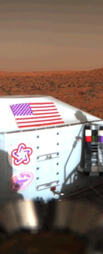
Viking Lander 1 U.S. Flag on Mars Surface
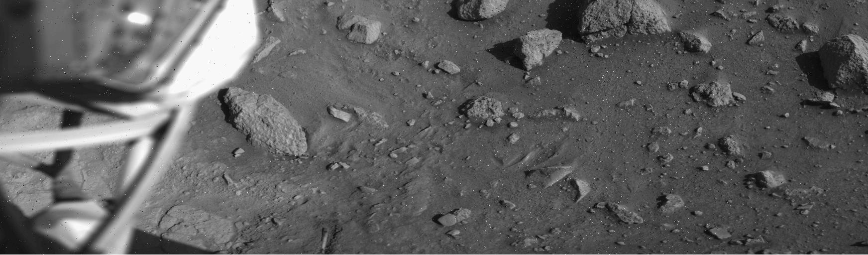
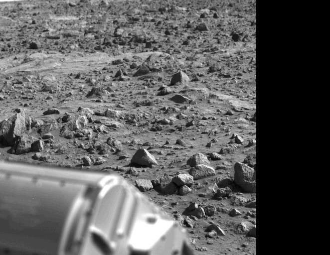
Mars Surface near Viking Lander 1 Footpad
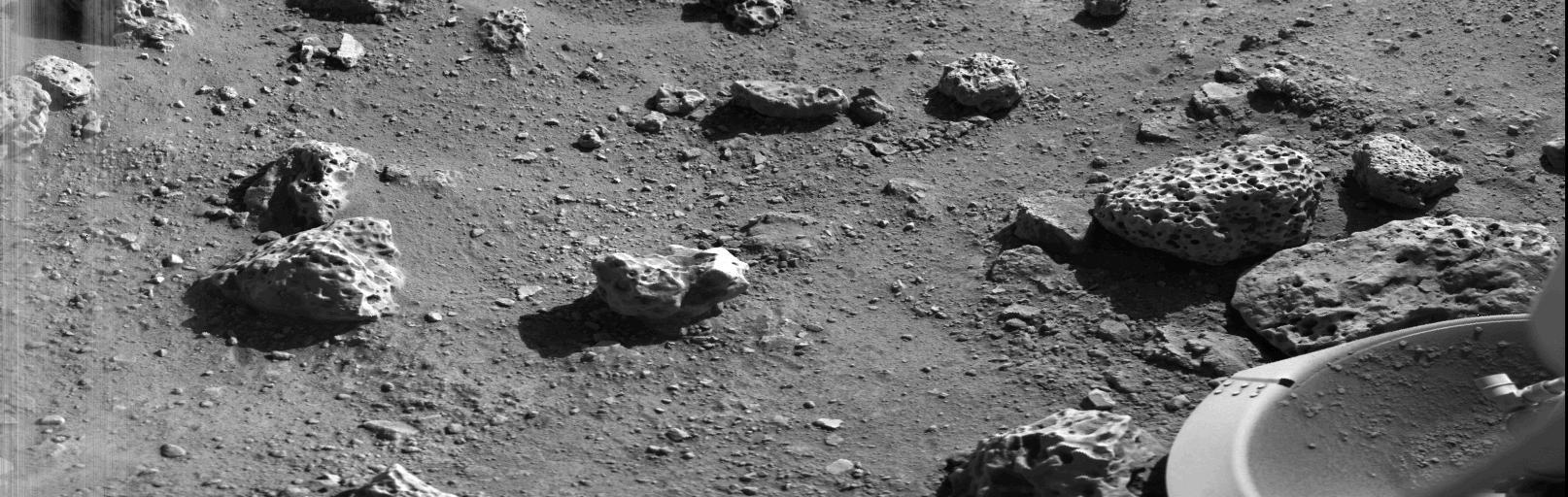
Viking Lander 2 First Picture On The Surface Of Mars http://photojournal.jpl.nasa.gov/catalog/PIA00396
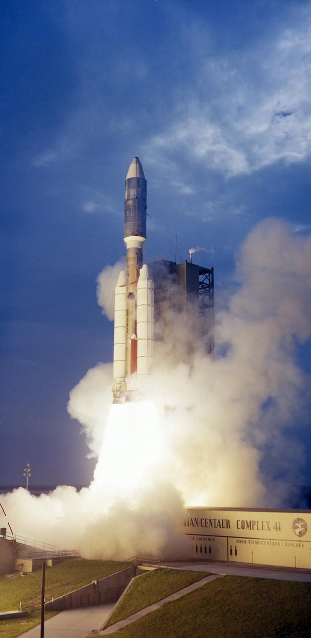
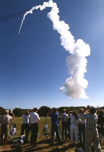
The Titan III-Centaur carrying the Viking 1 Lander lifted off on August 20, 1975. The Viking Lander conducted a detailed scientific investigation of the planet Mars.

Visitors learn about the Viking landers at the Smithsonian Institution’s National Air and Space Museum Mars Day, an annual event celebrating the Red Planet with exhibits, speakers, and educational activities, Friday, July 21, 2017 in Washington. Photo Credit: (NASA/Aubrey Gemignani)
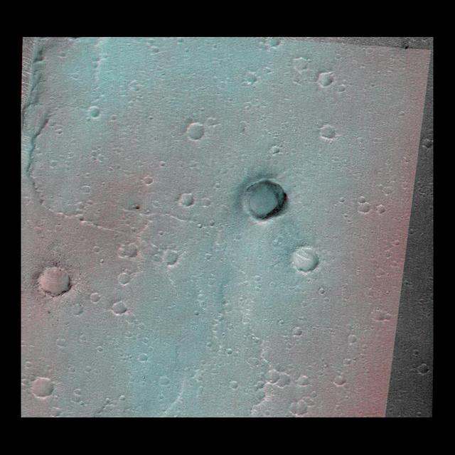
This image of the vicinity of the Viking Lander 1 was captured by NASA Mars Global Surveyor MOC camera. site. 3D glasses are necessary to identify surface detail.
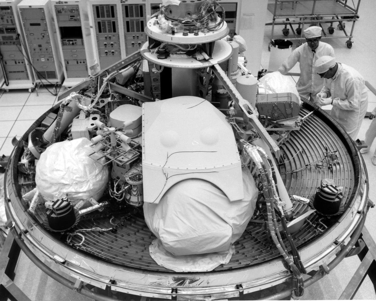
CAPE CANAVERAL, Fla. -- At the Kennedy Space Center in Florida, technicians inspect the Viking Lander 2 in Kennedy's Spacecraft Assembly and Encapsulation Facility 1. The first Viking is scheduled for launch from Launch Complex 41 no earlier than Aug. 11, 1975, the second, no earlier than Aug. 21, 1975. Once in orbit around Mars, the lander will detach and descend to the planet's surface to conduct further investigation. The Viking's 440-million-mile journey to the Red Planet will take about 11 months. Photo Credit: NASA
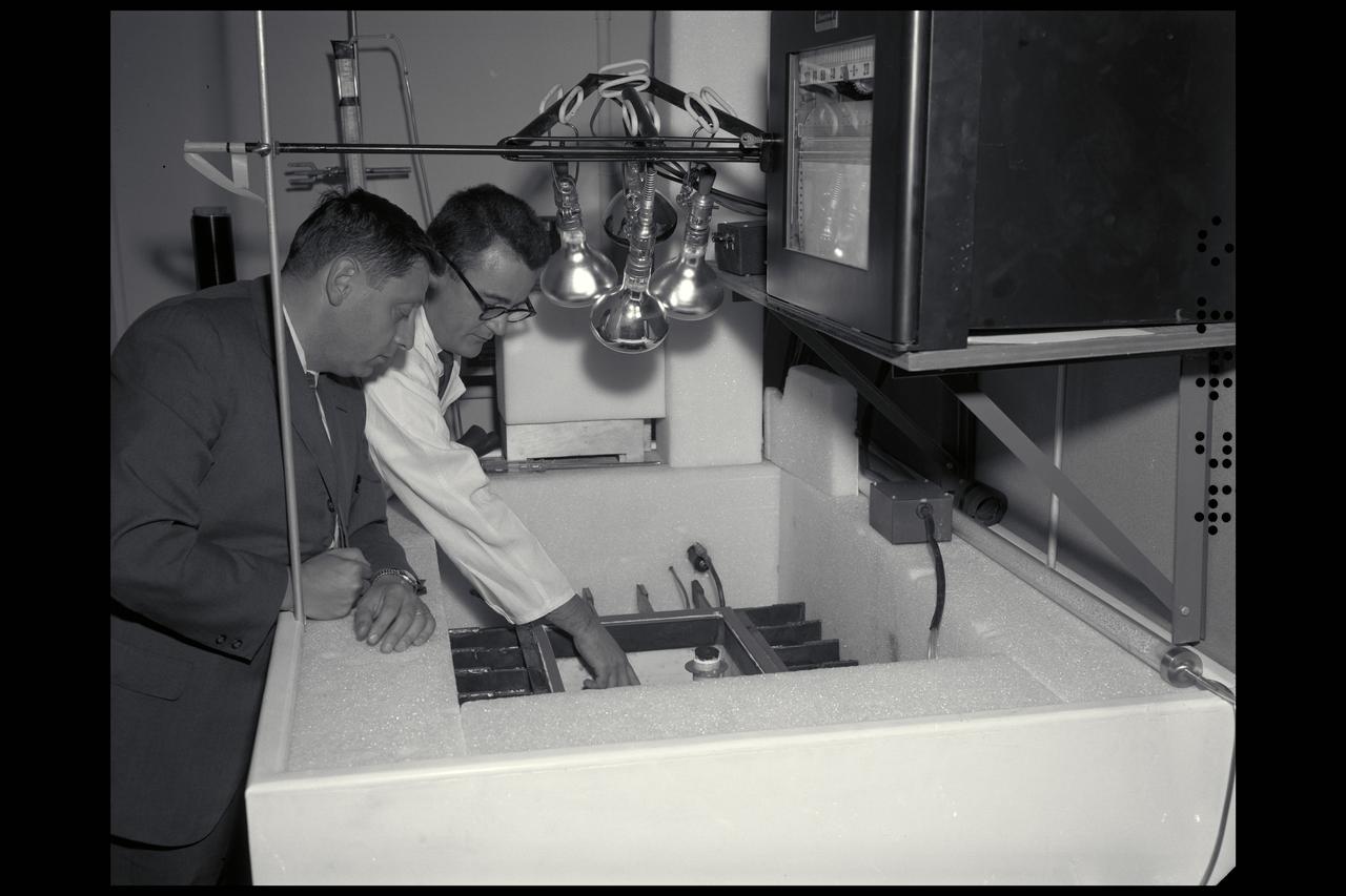
Dr H. 'Chuck' Klein (l) with Dr R. Young looking into the Mars box (simulator), which simulated the environment of Mars for the preparation of life sciences experiments for the Viking lander.
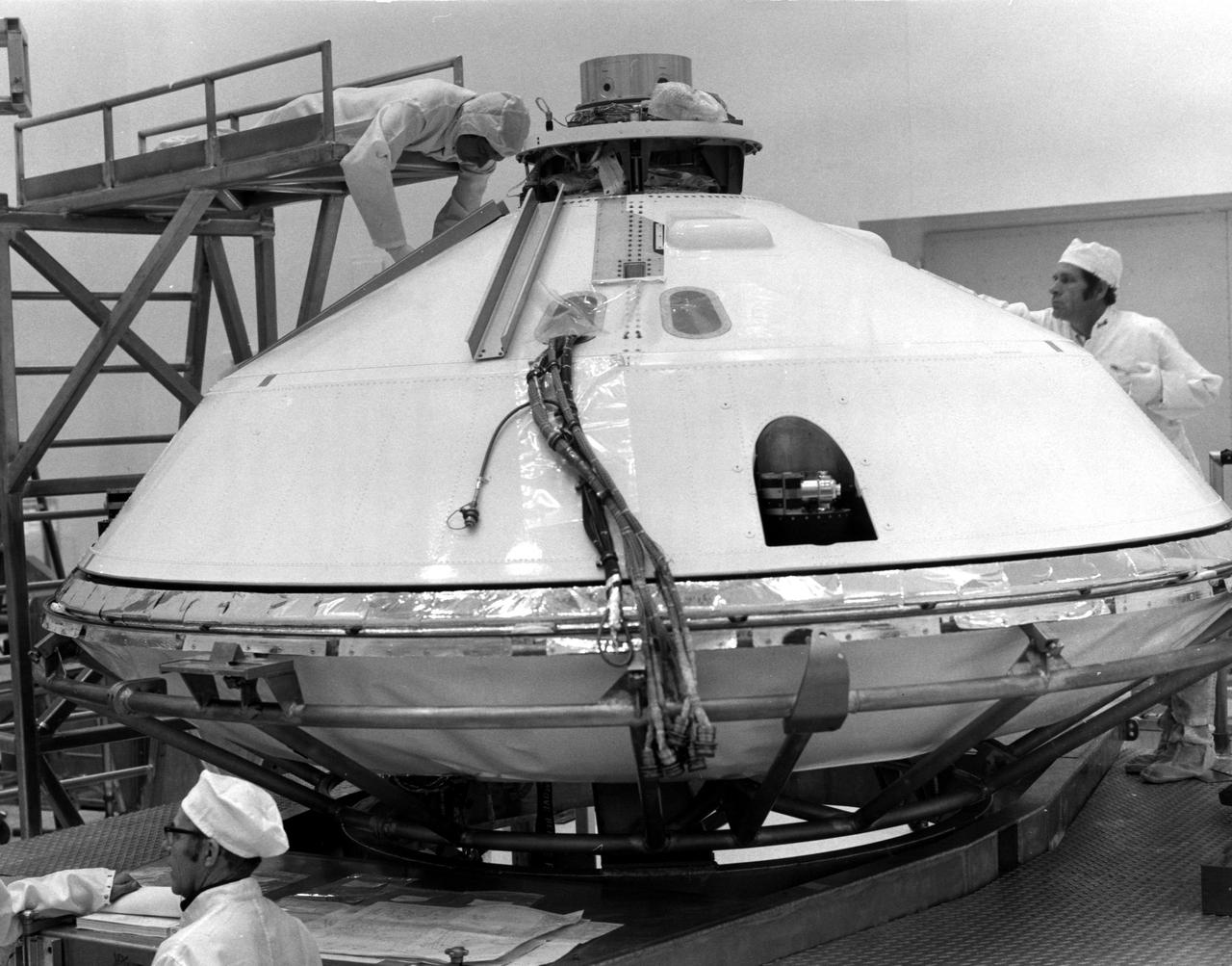
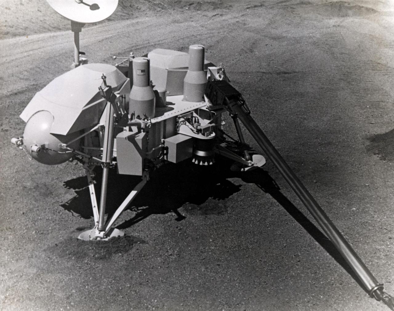
KENNEDY SPACE CENTER, FLA. -- Technicians prepared for removal of Viking Lander 1's aeroshell cover in KSC's Spacecraft Assembly and Encapsulation Facility 2 (SAEF-2) today. The cover remains over the Lander throughout its 440,000,000-mile journey to Mars. After the Lander separates from the Orbiter, the aeroshell will help to decelerate the speed of descent and will serve as a heat shield. After the aeroshell separates, the Lander's parachute will deploy at about 4,000 feet altitude to further slow descent for a soft landing on the Red Planet. The Kennedy Space Center will launch the first Viking from Complex 41, Cape Canaveral, no earlier than Aug. 11. The second Viking will be launched no earlier than Aug. 21.
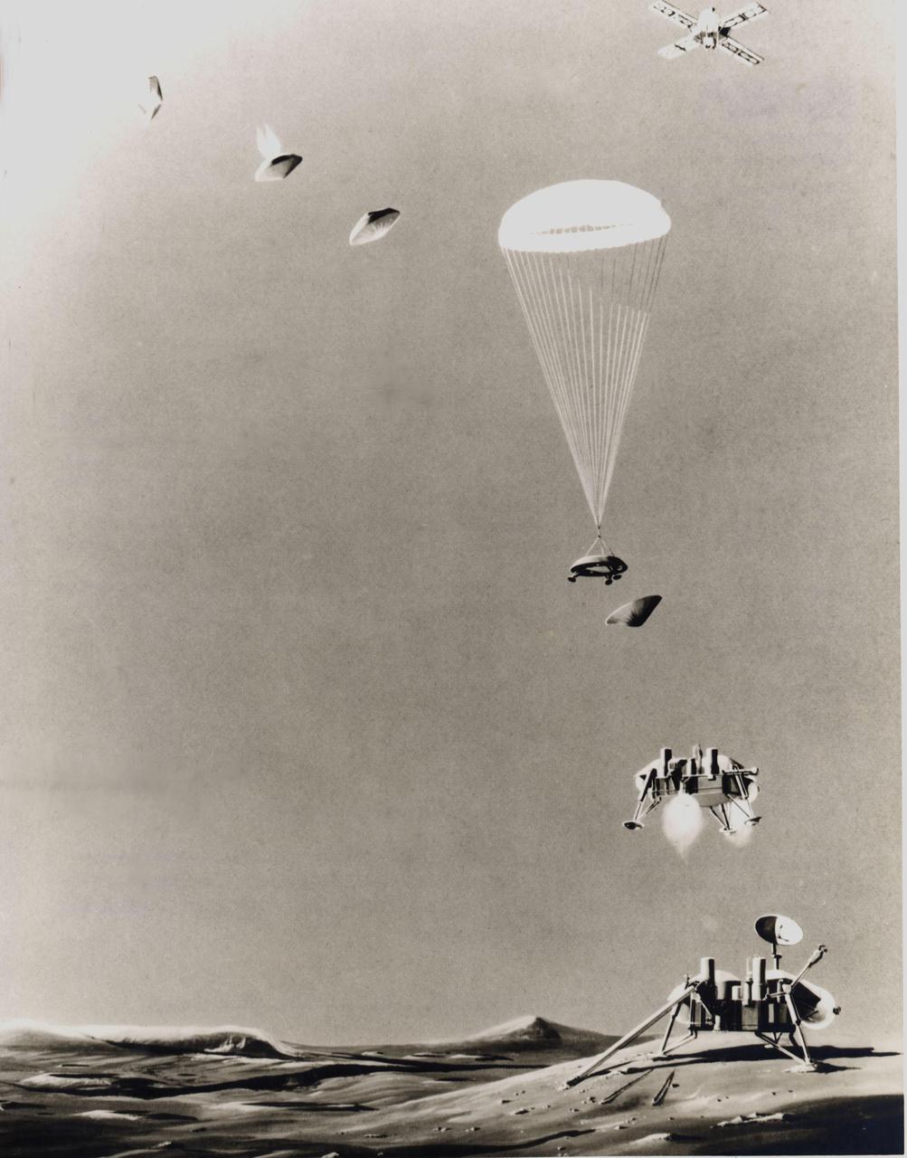
This is an artist's conception of the sequence of events that will take place just prior to landing a life-detection laboratory on the surface of Mars on July 4, 1976. Above right, the Viking spacecraft, composed of an orbiter and a lander, has been in orbit around the Red Planet since June 19, 1976, taking pictures of the planned landing site to ascertain its safety before releasing the lander (top, left) for its threeto five-hour descent. Protected by aeroshells, the heat-sterilized lander hurtles into the thin Martian atmosphere at a speed of about 10,000 mph, to be slowed first by aerodynamic drag until the shell is discarded, then by parachute (center) and finally by retrorockets to assure a gentle landing. Instruments will study the structure and composition of the Martian atmosphere as the lander drifts down. Viking 2 is scheduled to arrive at Mars on Aug. 7 and touch down on the surface on Sept. 4.
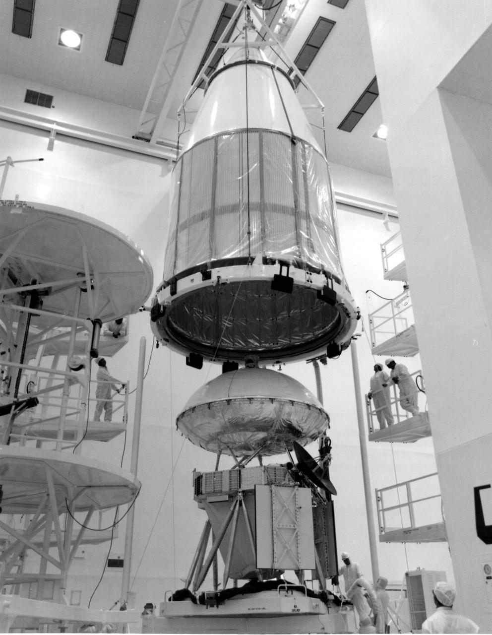
KENNEDY SPACE CENTER, FLA. -- The mated orbiter and lander for Viking A were encapsulated within a Centaur shroud at Spacecraft Assembly and Encapsulation Facility 2 (SAEF-2) today. The spacecraft, one of two to be launched toward Mars atop Titan_Centaurs in August, is to be moved to Launch Complex 41 on March 31 for extensive testing. KSC's Unmanned Launch Operations Directorate is scheduled to launch the twin Vikings during a 10-day period in August.
The work was among 25 projects funded by NASA’s Mars Exploration Program this past year to push the limits of future technologies. Sand dunes confused the navigation algorithm of the Ingenuity Mars helicopter during several of its last flights, including its 72nd and final flight on the Red Planet in January 2024. The navigation software in development would help future rotorcraft track the surface of especially bland, featureless terrain similar to the barren Dumont Dunes. Tests also included flights over a region in Death Valley called Mars Hill, which is littered with rubbly volcanic rocks and has been used by NASA’s Mars researchers since the 1970s, during preparations for the Viking lander missions.
The letter 'B' or perhaps the figure '8' appears to have been etched into the Mars rock at the left edge of this picture taken yesterday by NASA's Viking 1 Lander. It is believed to be an illusion caused by weathering processes and the angle of the sun as it illuminated the scene for the spacecraft camera. The object at lower left is the housing containing the surface sampler scoop. http://photojournal.jpl.nasa.gov/catalog/PIA00386
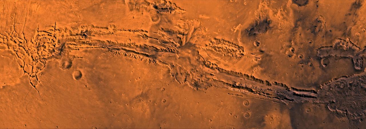
A color image of Valles Marineris, the great canyon of Mars; north toward top. The scene shows the entire canyon system, over 3,000 km long and averaging 8 km deep, extending from Noctis Labyrinthus, the arcuate system of graben to the west, to the chaotic terrain to the east. This image is a composite of Viking medium-resolution images in black and white and low-resolution images in color; Mercator projection. The image extends from latitude 0 degrees to 20 degrees S. and from longitude 45 degrees to 102.5 degrees. The connected chasma or valleys of Valles Marineris may have formed from a combination of erosional collapse and structural activity. Layers of material in the eastern canyons might consist of carbonates deposited in ancient lakes. Huge ancient river channels began from Valles Marineris and from adjacent canyons and ran north. Many of the channels flowed north into Chryse Basin, which contains the site of the Viking 1 Lander and the future site of the Mars Pathfinder Lander. http://photojournal.jpl.nasa.gov/catalog/PIA00422
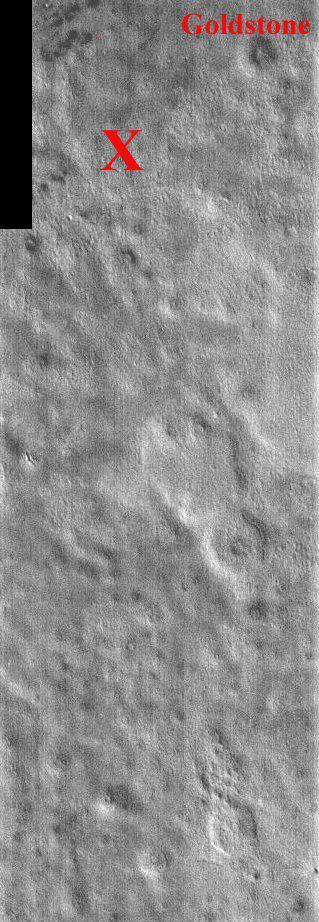
This portion of NASA Mars Odyssey image covers NASA Viking 2 landing site shown with the X. The second landing on Mars took place September 3, 1976 in Utopia Planitia. The exact location of Lander 2 is not as well established as Lander 1 because there were no clearly identifiable features in the lander images as there were for the site of Lander 1. The Utopia landing site region contains pedestal craters, shallow swales and gentle ridges. The crater Goldstone was named in honor of the Tracking Station in the desert of California. The two Viking Landers operated for over 6 years (nearly four martian years) after landing. This one band IR (band 9 at 12.6 microns) image shows bright and dark textures, which are primarily due to differences in the abundance of rocks on the surface. The relatively cool (dark) regions during the day are rocky or indurated materials, fine sand and dust are warmer (bright). Many of the temperature variations are due to slope effects, with sun-facing slopes warmer than shaded slopes. The dark rings around several of the craters are due to the presence of rocky (cool) material ejected from the crater. These rocks are well below the resolution of any existing Mars camera, but THEMIS can detect the temperature variations they produce. Daytime temperature variations are produced by a combination of topographic (solar heating) and thermophysical (thermal inertia and albedo) effects. Due to topographic heating the surface morphologies seen in THEMIS daytime IR images are similar to those seen in previous imagery and MOLA topography. http://photojournal.jpl.nasa.gov/catalog/PIA04023
Somewhere down there sits the Mars Pathfinder lander and Sojourner rover. This Mars Global Surveyor Mars Orbiter Camera view of the red planet shows the region that includes Ares Vallis and the Chryse Plains upon which both Mars Pathfinder and the Viking 1 landed in 1997 and 1976, respectively. Acidalia Planitia is the dark surface that dominates the center left. The Pathfinder site is immediately south of Acidalia, just left of center in this view. Also shown--the north polar cap is at the top, and Arabia Terra and Sinus Meridiani are to the right. The bluish-white features are clouds. This is a color composite of 9 red and 9 blue image strips taken by the Mars Global Surveyor Mars Orbiter Camera on 9 successive orbits from pole-to-pole during the calibration phase of the mission in March 1999. The color is computer-enhanced and is not shown as it would actually appear to the human eye. http://photojournal.jpl.nasa.gov/catalog/PIA02000

The interior of Mars is simply modeled as a core and mantle with a thin crust, similar to Earth. Mars' size and total mass have been determined by previous missions. Given four parameters, the core size and mass, and mantle size and mass can be determined. The combination of Pathfinder Doppler data with earlier data from the Viking landers has determined a third parameter, the moment of inertia, through measurement of Mars' precession rate. A fourth measurement is needed to complete the interior model. This may be achieved through future Doppler tracking of Pathfinder, since the presence of a fluid core may be detectable through its effect on Mars' nutation. The determination of the moment of inertia is a significant constraint on possible models for Mars' interior. If the core is as dense as possible (i.e. completely iron) and the mantle is similar to Earth's (or similar to the SNC meteorites thought to originate on Mars) then the minimum core radius is about 1300 km. If the core is made of less-dense material (i.e. a mixture of iron and sulfur) then the core radius is probably no more than 2000 km. Sojourner spent 83 days of a planned seven-day mission exploring the Martian terrain, acquiring images, and taking chemical, atmospheric and other measurements. The final data transmission received from Pathfinder was at 10:23 UTC on September 27, 1997. Although mission managers tried to restore full communications during the following five months, the successful mission was terminated on March 10, 1998. http://photojournal.jpl.nasa.gov/catalog/PIA00974
The work was among 25 projects funded by NASA’s Mars Exploration Program this past year to push the limits of future technologies. Sand dunes confused the navigation algorithm of the Ingenuity Mars helicopter during several of its last flights, including its 72nd and final flight on the Red Planet in January 2024. The navigation software in development would help future rotorcraft track the surface of especially bland, featureless terrain similar to the barren sand dunes seen in Death Valley’s Mesquite Flats Sand Dunes as well as in Dumont Dunes in the Mojave Desert, where testing was also conducted. Tests included flights over a region in Death Valley called Mars Hill, which is littered with rubbly volcanic rocks and has been used by NASA’s Mars researchers since the 1970s, during preparations for the Viking lander missions.
KENNEDY SPACE CENTER, FLA. -- Viking Project In 1976: NASA will land two automated scientific laboratories on the planet Mars. This pioneering effort to explore in detail the surface of another primary planet in our solar system will be identified by a name that exemplifies the spirit of historic exploration. To accomplish this goal, two spacecraft will be launched from the Kennedy Space Center within a month of another in mid-1975. These spacecraft, each including a lander and an orbiter, will hurtle nearly 460 million miles around the Sun before reaching the red planet. The descent will occur when Mars is about 225 million miles from Earth and nearly on the other side of the Sun. This requires a completely automated de-orbit and landing operation because, at that distance, two-way communication between Mars and Earth takes nearly 45 minutes. Surface science will then commence with principal scientific interest invested in biology, geology and meteorology.
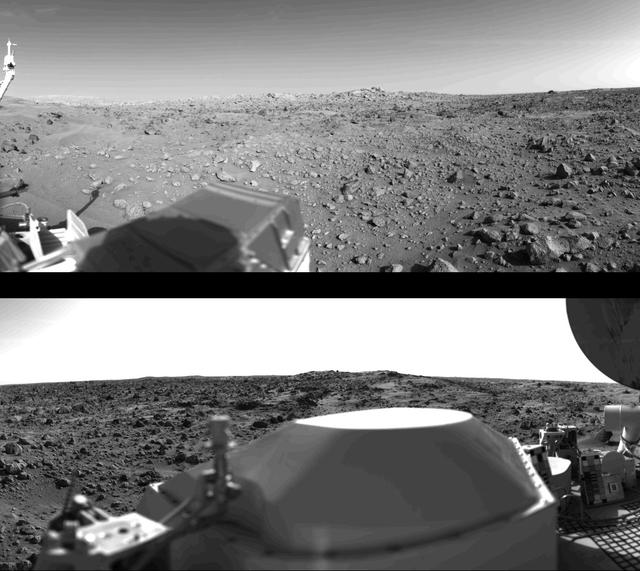
First panoramic view by Viking 1 from the surface of Mars. (Top): The out-of-focus spacecraft component toward left center is the housing for the Viking sample arm, which is not yet deployed. Parallel lines in the sky are an artifact and are not real features. However, the change of brightness from horizon towards zenith and towards the right (west) is accurately reflected in this picture, taken in late Martian afternoon. At the horizon to the left is a plateau-like prominence much brighter than the foreground material between the rocks. The horizon features are approximately three kilometers (1.8 miles) away. At left is a collection of fine-grained material reminiscent of sand dunes. The dark sinuous markings in left foreground are of unknown origin. Some unidentified shapes can be perceived on the hilly eminence at the horizon towards the right. Patches of bright sand can be discerned among the rocks and boulders in middle distance. In right fore-ground are two peculiarly shaped rocks which may possibly be ventifacts produced by wind abrasion on Mars. A horizontal cloud stratum can be made out halfway from the horizon to the top of the picture. (Bottom): At left is seen the low gain antenna for receipt of commands from the Earth. The projections on or near the horizon may represent the rims distant impact craters. In right foreground are color charts for Lander camera calibration, a mirror for the Viking magnetic properties experiment and part of a grid on the top of the Lander body. At upper right is the high-gain dish antenna for direct communication between landed space-craft and Earth. Toward the right edge is an array of smooth fine-grained material which shows some hint of ripple structure and may be the beginning of a large dune field off to the right of the picture, which joins with dunes seen at the top left in this 300 panoramic view. Some of the rocks appear to be undercut on one side and partially buried by drifting sand on the other. http://photojournal.jpl.nasa.gov/catalog/PIA00382
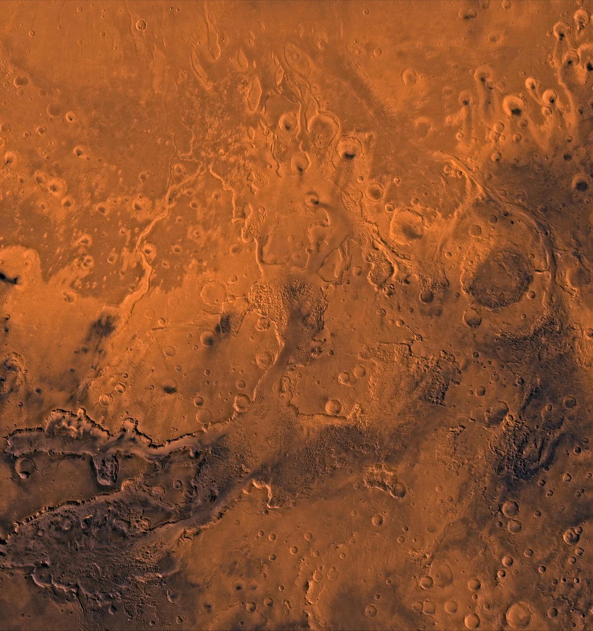
A color image of the south Chryse basin Valles Marineris outflow channels on Mars; north toward top. The scene shows on the southwest corner the chaotic terrain of the east part of Valles Marineris and two of its related canyons: Eos and Capri Chasmata (south to north). Ganges Chasma lies directly north. The chaos in the southern part of the image gives rise to several outflow channels, Shalbatana, Simud, Tiu, and Ares Valles (left to right), that drained north into the Chryse basin. The mouth of Ares Valles is the site of the Mars Pathfinder lander. This image is a composite of NASA's Viking medium-resolution images in black and white and low-resolution images in color. The image extends from latitude 20 degrees S. to 20 degrees N. and from longitude 15 degrees to 53 degrees; Mercator projection. http://photojournal.jpl.nasa.gov/catalog/PIA00418
The journey back to Mars begins with a liftoff of the Mars Global Surveyor atop a Delta II 7925A expendable launch vehicle from the Cape Canaveral Air Station. After an approximate 10-month interplanetary odyssey, the spacecraft will arrive at Mars and begin a 4-month aerobreaking phase, an irnovative technique first demonstrated during the Magellan mission to Venus, to achieve a mapping orbit. It will take about 2 Earth years for Surveyor to circle above most of the planet, its suite of sophisticated remote-sensing instruments building a comprehensive global portrait of Mars by mapping its topography, magnetism, mineral composition and atmosphere. Among the locations the Surveyor will pass over are the landing sites where the two U.S. Viking landers have stood since 1975 as silent monuments to the most recent successful U.S. missions to Mars. The Global Surveyor is the first of a trio of spacecraft being launched to Mars; next is Russia's Mars `96 spacecraft, followed by the U.S.'s Mars Pathfinder.
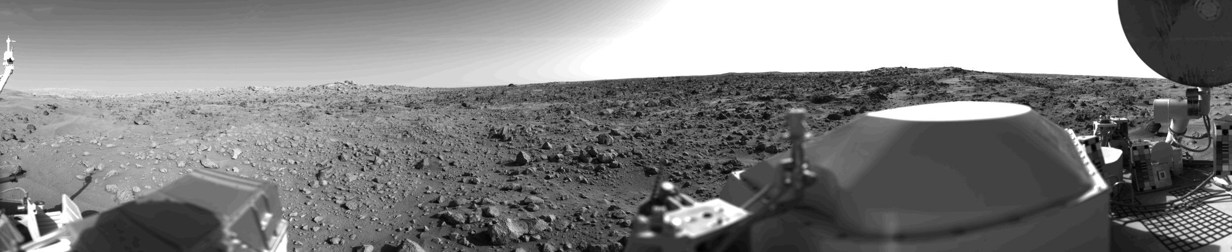
First panoramic view by NASA's Viking 1 from the surface of Mars. The out of focus spacecraft component toward left center is the housing for the Viking sample arm, which is not yet deployed. Parallel lines in the sky are an artifact and are not real features. However, the change of brightness from horizon towards zenith and towards the right (west) is accurately reflected in this picture, taken in late Martian afternoon. At the horizon to the left is a plateau-like prominence much brighter than the foreground material between the rocks. The horizon features are approximately three kilometers (1.8 miles) away. At left is a collection of fine-grained material reminiscent of sand dunes. The dark sinuous markings in left foreground are of unknown origin. Some unidentified shapes can be perceived on the hilly eminence at the horizon towards the right. A horizontal cloud stratum can be made out halfway from the horizon to the top of the picture. At left is seen the low gain antenna for receipt of commands from the Earth. The projections on or near the horizon may represent the rims distant impact craters. In right foreground are color charts for Lander camera calibration, a mirror for the Viking magnetic properties experiment and part of a grid on the top of the Lander body. At upper right is the high gain dish antenna for direct communication between landed spacecraft and Earth. Toward the right edge is an array of smooth fine-grained material which shows some hint of ripple structure and may be the beginning of a large dune field off to the right of the picture, which joins with dunes seen at the top left in this 300 degree panoramic view. Some of the rocks appear to be undercut on one side and partially buried by drifting sand on the other. http://photojournal.jpl.nasa.gov/catalog/PIA00383
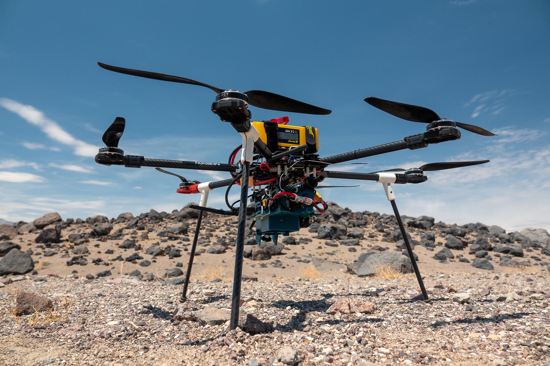
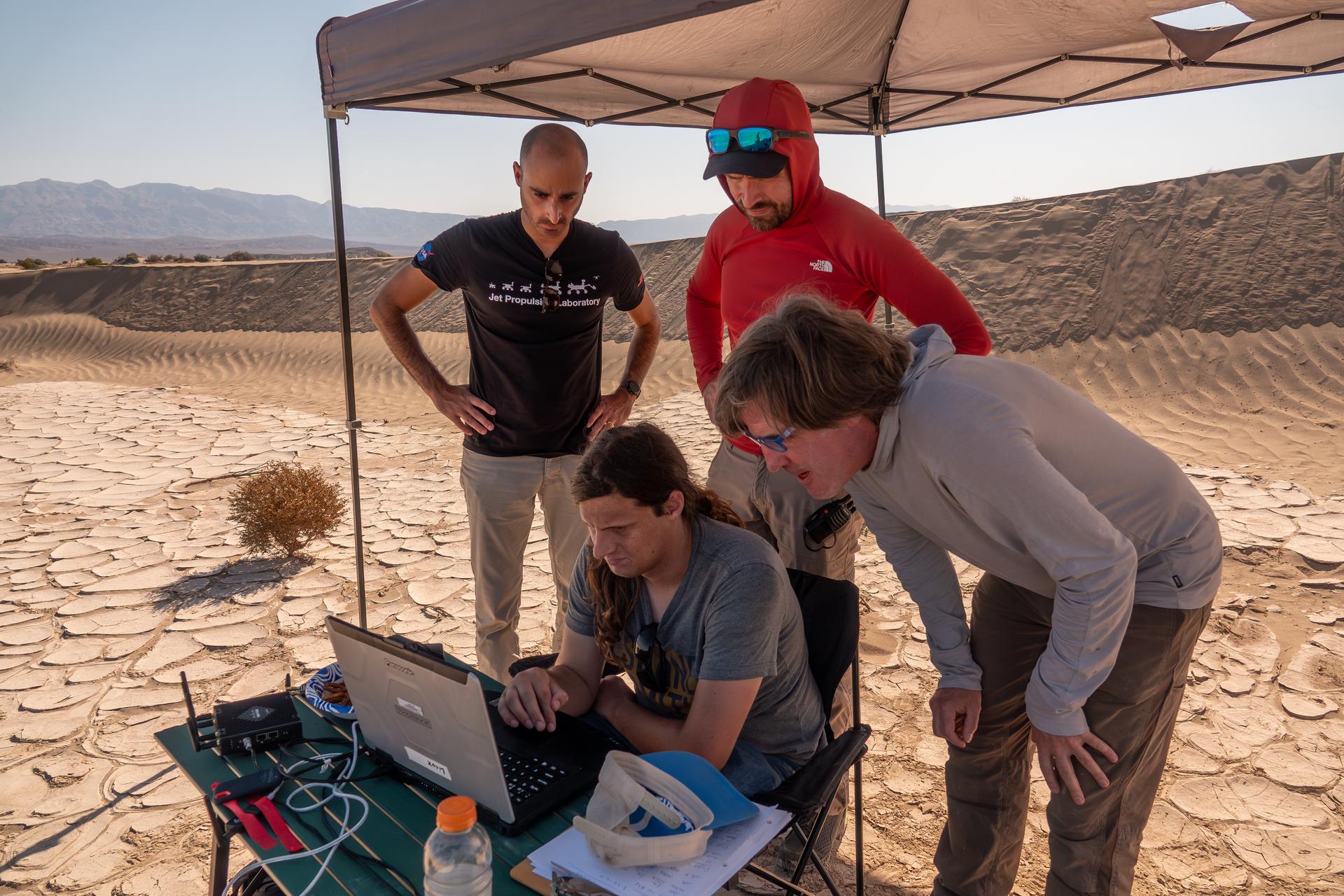
This is one of three research drones that NASA’s Jet Propulsion Laboratory in Southern California used in September 2025 to test navigation software that could be used by future rotorcraft on Mars. The drone is sitting in front of a location within Death Valley National Park called Mars Hill, which is littered with rubbly volcanic rocks and has been used by NASA’s Mars researchers since the 1970s, during preparations for the Viking lander missions. The work was among 25 projects funded by NASA’s Mars Exploration Program this past year to push the limits of future technologies. Sand dunes confused the navigation algorithm of the Ingenuity Mars helicopter during several of its last flights, including its 72nd and final flight on the Red Planet in January 2024. The navigation software in development would help future rotorcraft to track the surface of especially bland, featureless terrain similar to the barren sand dunes seen in parts of Death Valley and to land safely in cluttered environments like Mars Hill.

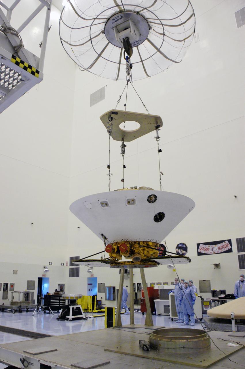
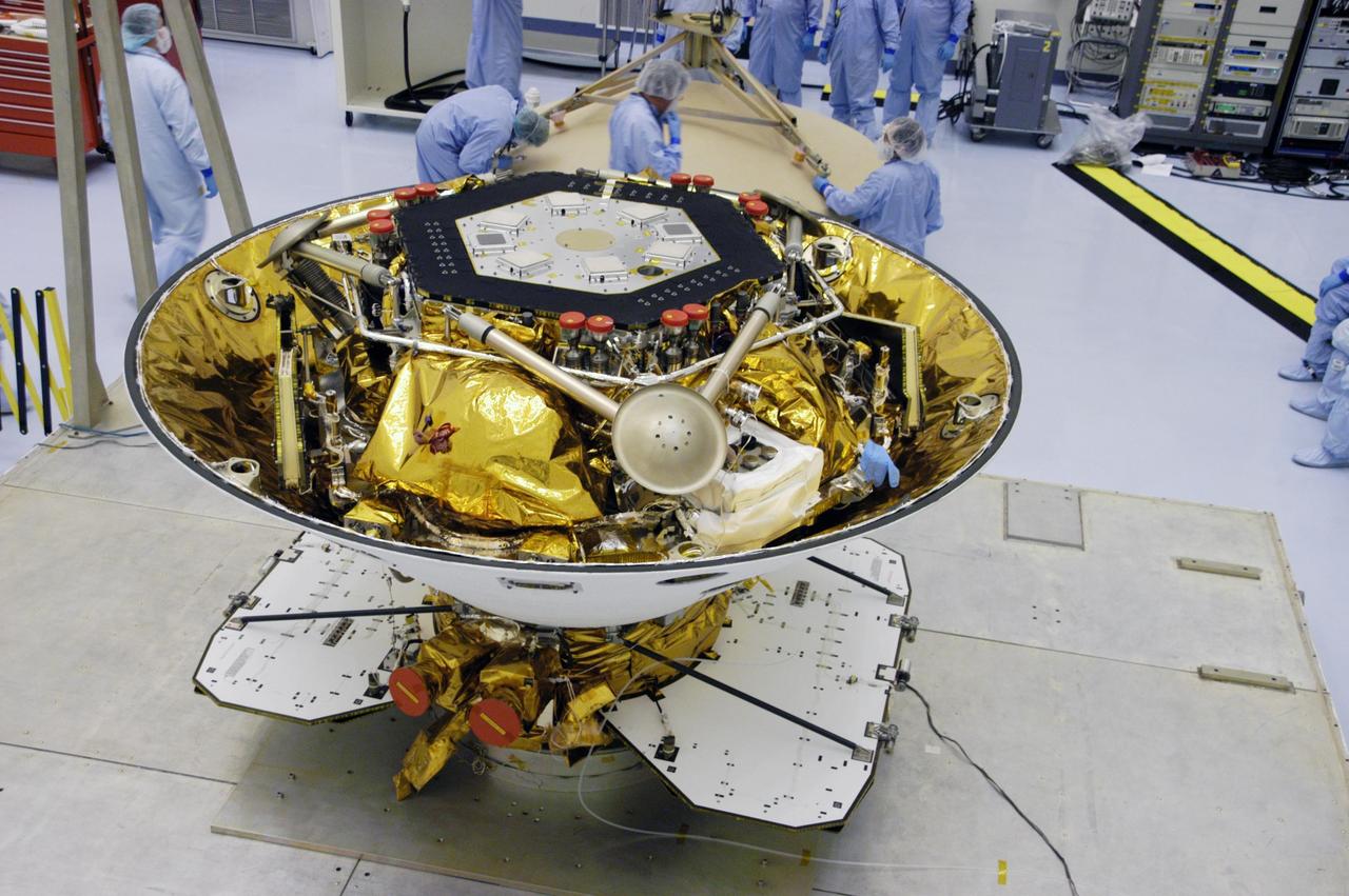
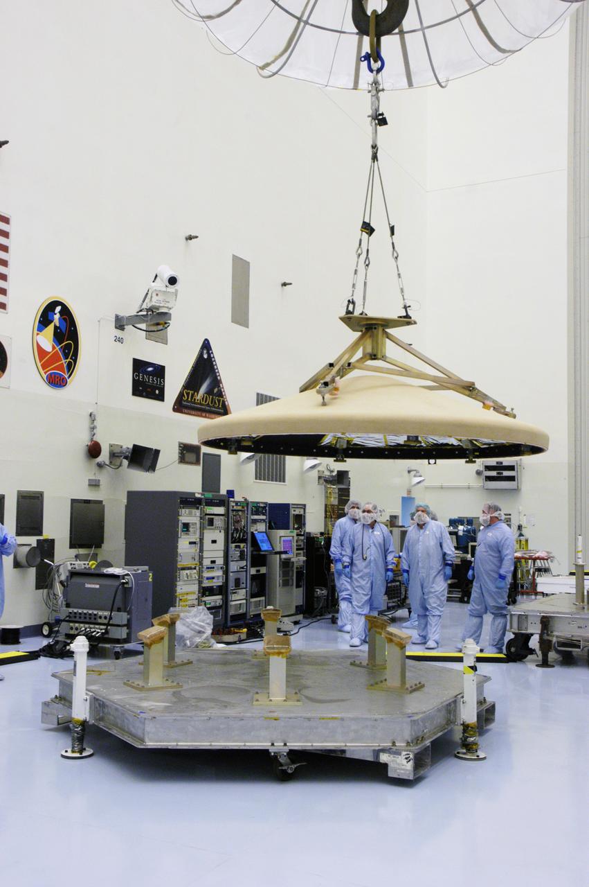
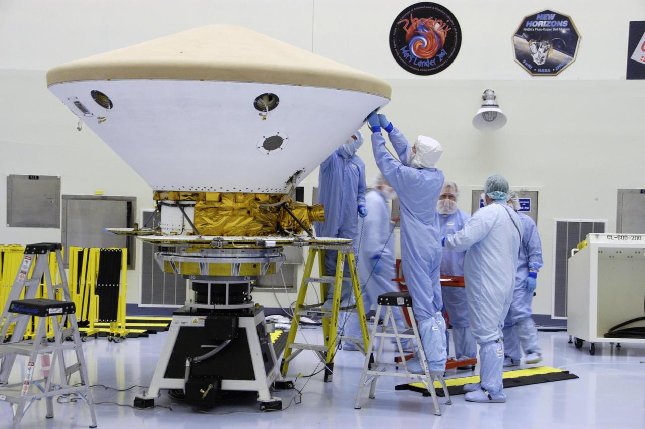
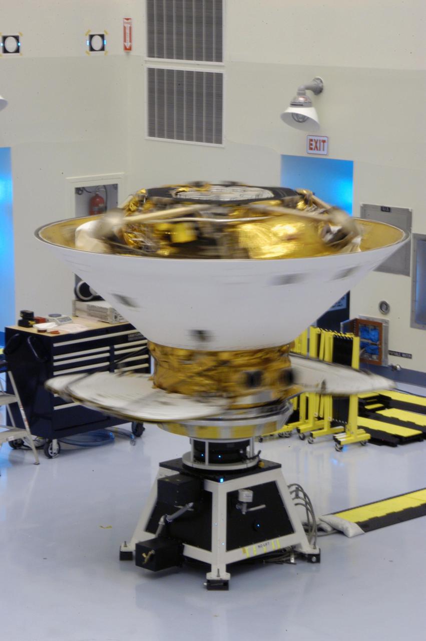
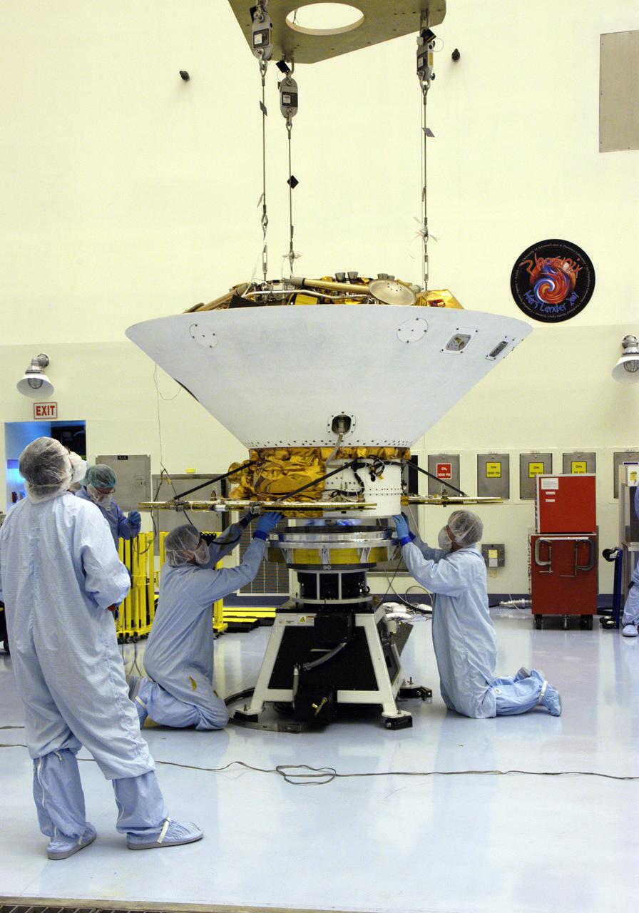
In the Payload Hazardous Servicing Facility, technicians lower a crane over the Phoenix Mars Lander spacecraft. The crane will be used to remove the heat shield from around the Phoenix. The Phoenix mission is the first project in NASA's first openly competed program of Mars Scout missions. Phoenix will land in icy soils near the north polar permanent ice cap of Mars and explore the history of the water in these soils and any associated rocks, while monitoring polar climate. Landing is planned in May 2008 on arctic ground where a mission currently in orbit, Mars Odyssey, has detected high concentrations of ice just beneath the top layer of soil. It will serve as NASA's first exploration of a potential modern habitat on Mars and open the door to a renewed search for carbon-bearing compounds, last attempted with NASA’s Viking missions in the 1970s. A stereo color camera and a weather station will study the surrounding environment while the other instruments check excavated soil samples for water, organic chemicals and conditions that could indicate whether the site was ever hospitable to life. Microscopes can reveal features as small as one one-thousandth the width of a human hair. Launch of Phoenix aboard a Delta II rocket is targeted for Aug. 3 from Cape Canaveral Air Force Station in Florida.
KENNEDY SPACE CENTER, FLA. -- Secured on the spin table, the backshell with the Phoenix Mars Lander inside is ready for spin testing in the Payload Hazardous Servicing Facility. The Phoenix mission is the first project in NASA's first openly competed program of Mars Scout missions. Phoenix will land in icy soils near the north polar permanent ice cap of Mars and explore the history of the water in these soils and any associated rocks, while monitoring polar climate. Landing is planned in May 2008 on arctic ground where a mission currently in orbit, Mars Odyssey, has detected high concentrations of ice just beneath the top layer of soil. It will serve as NASA's first exploration of a potential modern habitat on Mars and open the door to a renewed search for carbon-bearing compounds, last attempted with NASA’s Viking missions in the 1970s. A stereo color camera and a weather station will study the surrounding environment while the other instruments check excavated soil samples for water, organic chemicals and conditions that could indicate whether the site was ever hospitable to life. Microscopes can reveal features as small as one one-thousandth the width of a human hair. Launch of Phoenix aboard a Delta II rocket is targeted for Aug. 3 from Cape Canaveral Air Force Station in Florida. Photo credit: NASA/George Shelton
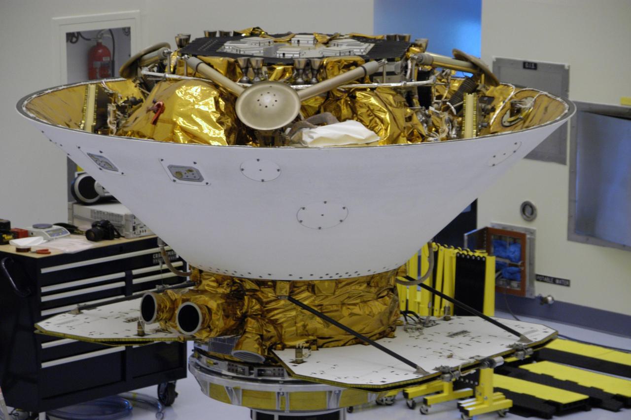
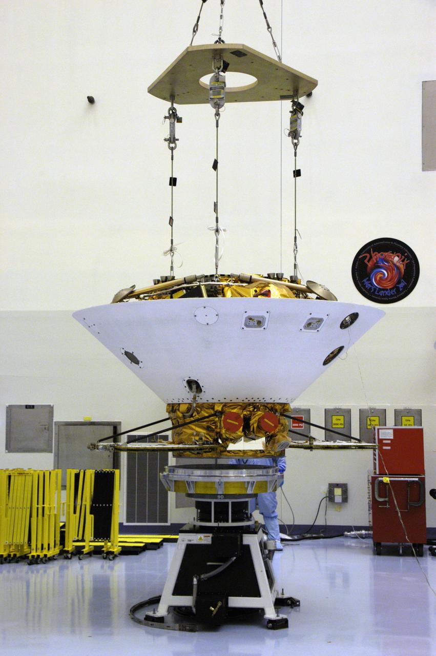
KENNEDY SPACE CENTER, FLA. -- This closeup shows the Phoenix Mars Lander spacecraft nestled inside the backshell. The spacecraft will undergo spin testing on the spin table to which it is attached in the Payload Hazardous Servicing Facility. The Phoenix mission is the first project in NASA's first openly competed program of Mars Scout missions. Phoenix will land in icy soils near the north polar permanent ice cap of Mars and explore the history of the water in these soils and any associated rocks, while monitoring polar climate. Landing is planned in May 2008 on arctic ground where a mission currently in orbit, Mars Odyssey, has detected high concentrations of ice just beneath the top layer of soil. It will serve as NASA's first exploration of a potential modern habitat on Mars and open the door to a renewed search for carbon-bearing compounds, last attempted with NASA’s Viking missions in the 1970s. A stereo color camera and a weather station will study the surrounding environment while the other instruments check excavated soil samples for water, organic chemicals and conditions that could indicate whether the site was ever hospitable to life. Microscopes can reveal features as small as one one-thousandth the width of a human hair. Launch of Phoenix aboard a Delta II rocket is targeted for Aug. 3 from Cape Canaveral Air Force Station in Florida. Photo credit: NASA/George Shelton
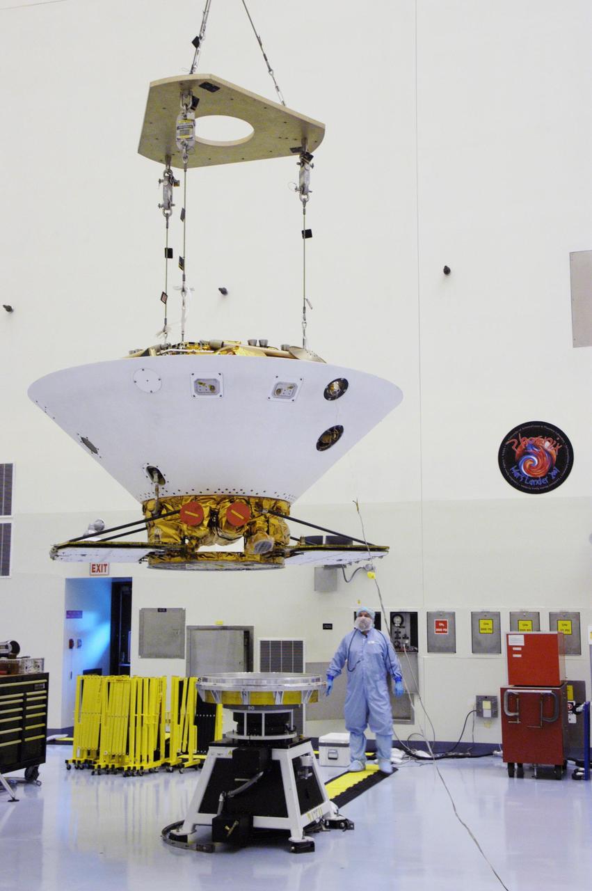
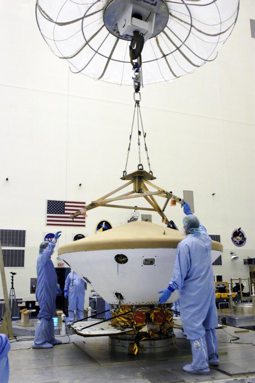
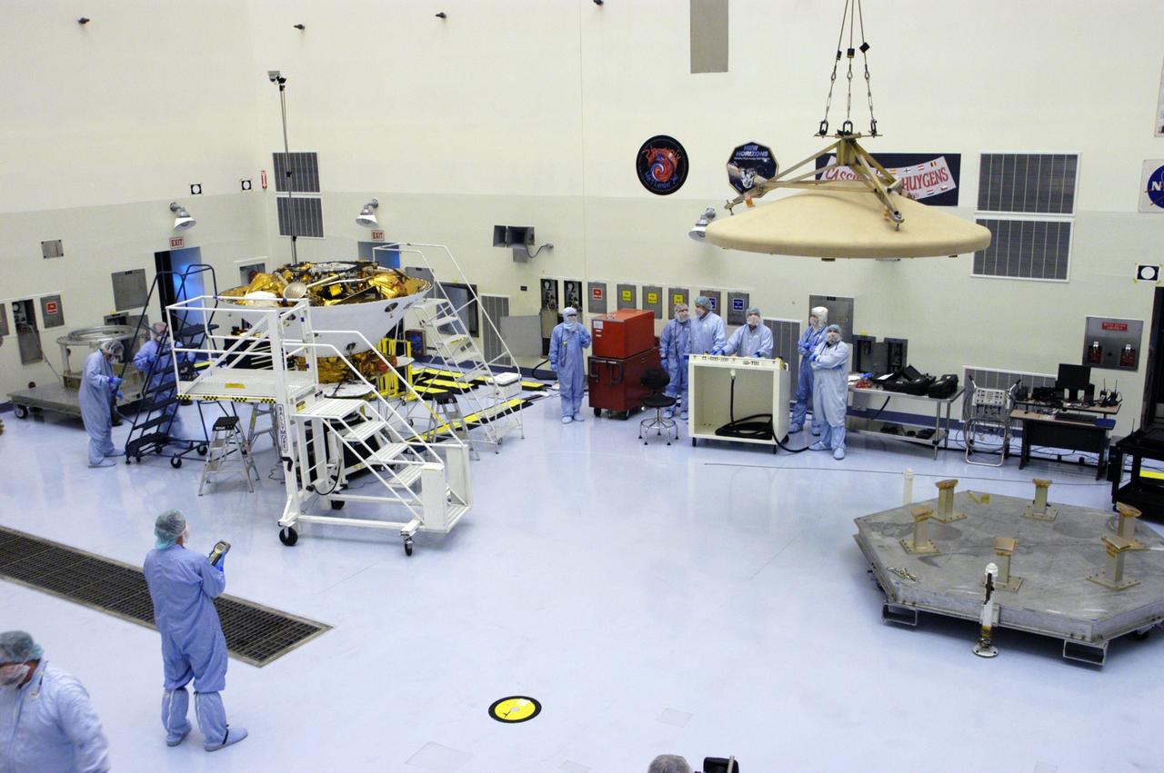
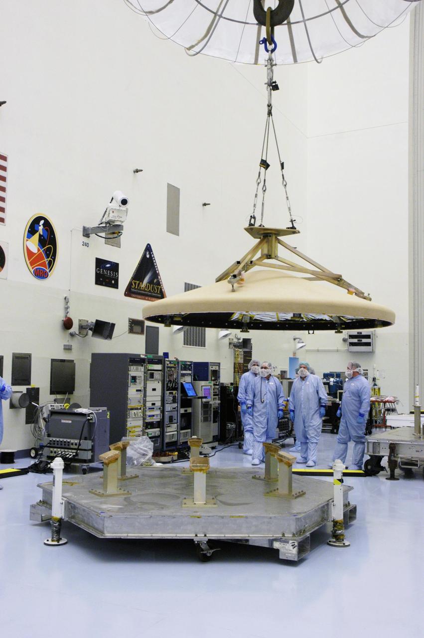
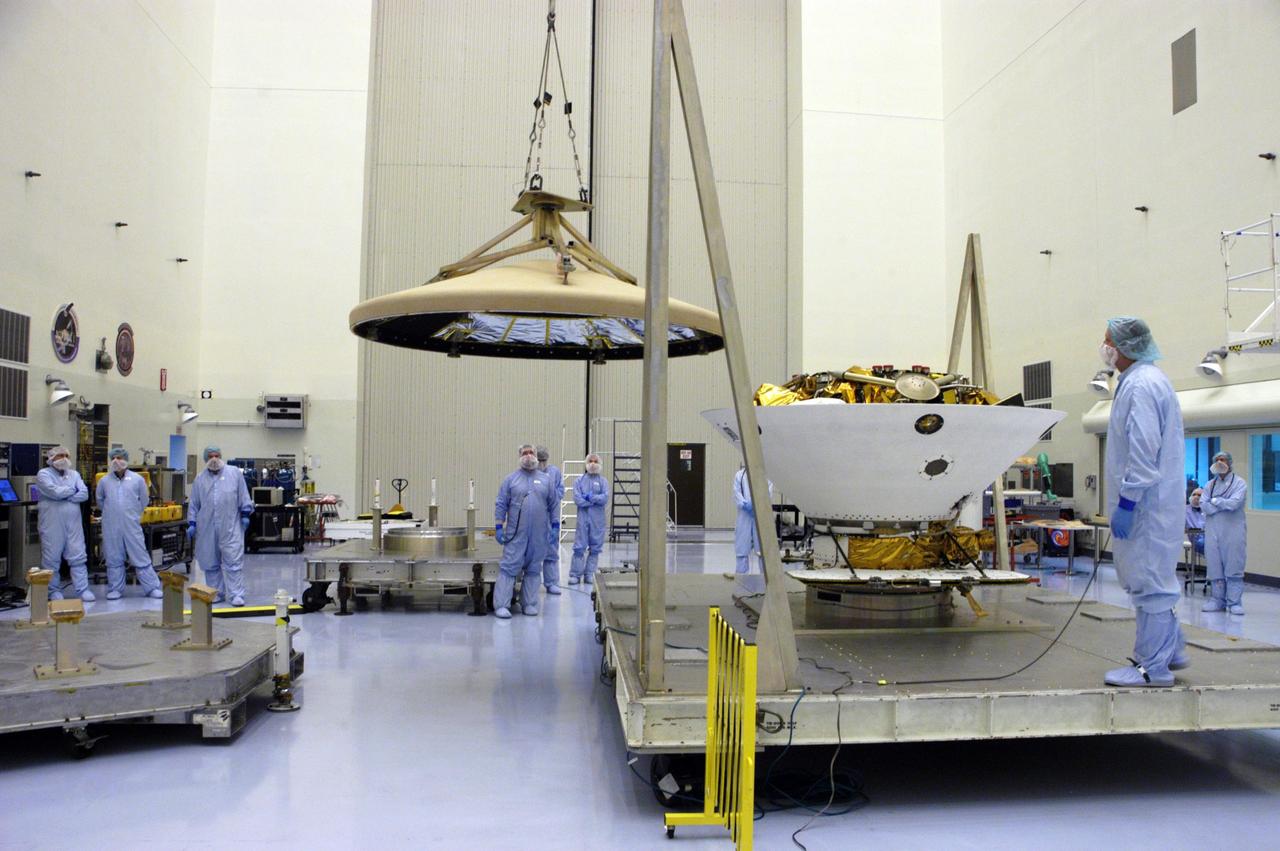
An overhead crane lifts the backshell with the Phoenix Mars Lander inside off its work stand in the Payload Hazardous Servicing Facility. The spacecraft is being moved to a spin table (back left) for spin testing. The Phoenix mission is the first project in NASA's first openly competed program of Mars Scout missions. Phoenix will land in icy soils near the north polar permanent ice cap of Mars and explore the history of the water in these soils and any associated rocks, while monitoring polar climate. Landing is planned in May 2008 on arctic ground where a mission currently in orbit, Mars Odyssey, has detected high concentrations of ice just beneath the top layer of soil. It will serve as NASA's first exploration of a potential modern habitat on Mars and open the door to a renewed search for carbon-bearing compounds, last attempted with NASA’s Viking missions in the 1970s. A stereo color camera and a weather station will study the surrounding environment while the other instruments check excavated soil samples for water, organic chemicals and conditions that could indicate whether the site was ever hospitable to life. Microscopes can reveal features as small as one one-thousandth the width of a human hair. Launch of Phoenix aboard a Delta II rocket is targeted for Aug. 3 from Cape Canaveral Air Force Station in Florida.

In the Payload Hazardous Servicing Facility, an overhead crane lifts the heat shield from the Phoenix Mars Lander spacecraft. The Phoenix mission is the first project in NASA's first openly competed program of Mars Scout missions. Phoenix will land in icy soils near the north polar permanent ice cap of Mars and explore the history of the water in these soils and any associated rocks, while monitoring polar climate. Landing is planned in May 2008 on arctic ground where a mission currently in orbit, Mars Odyssey, has detected high concentrations of ice just beneath the top layer of soil. It will serve as NASA's first exploration of a potential modern habitat on Mars and open the door to a renewed search for carbon-bearing compounds, last attempted with NASA’s Viking missions in the 1970s. A stereo color camera and a weather station will study the surrounding environment while the other instruments check excavated soil samples for water, organic chemicals and conditions that could indicate whether the site was ever hospitable to life. Microscopes can reveal features as small as one one-thousandth the width of a human hair. Launch of Phoenix aboard a Delta II rocket is targeted for Aug. 3 from Cape Canaveral Air Force Station in Florida.
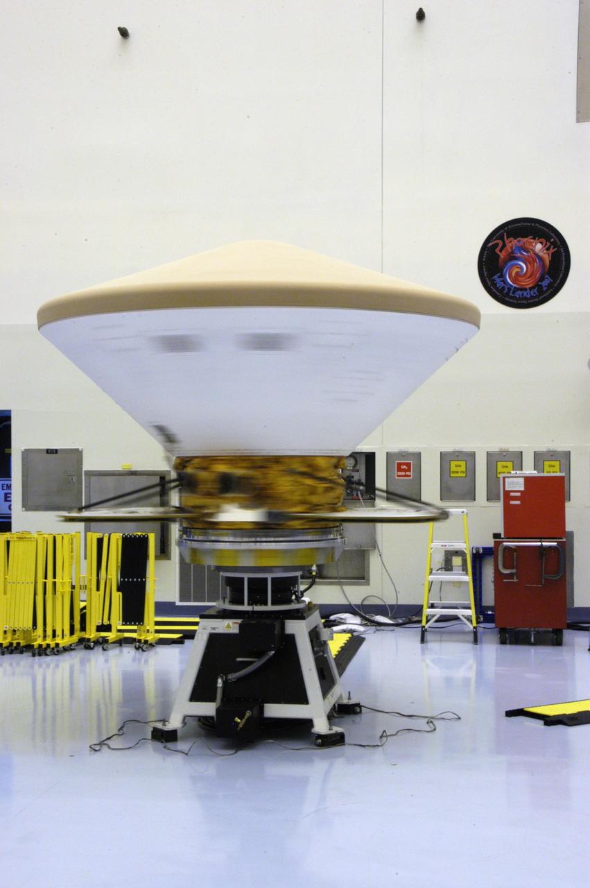
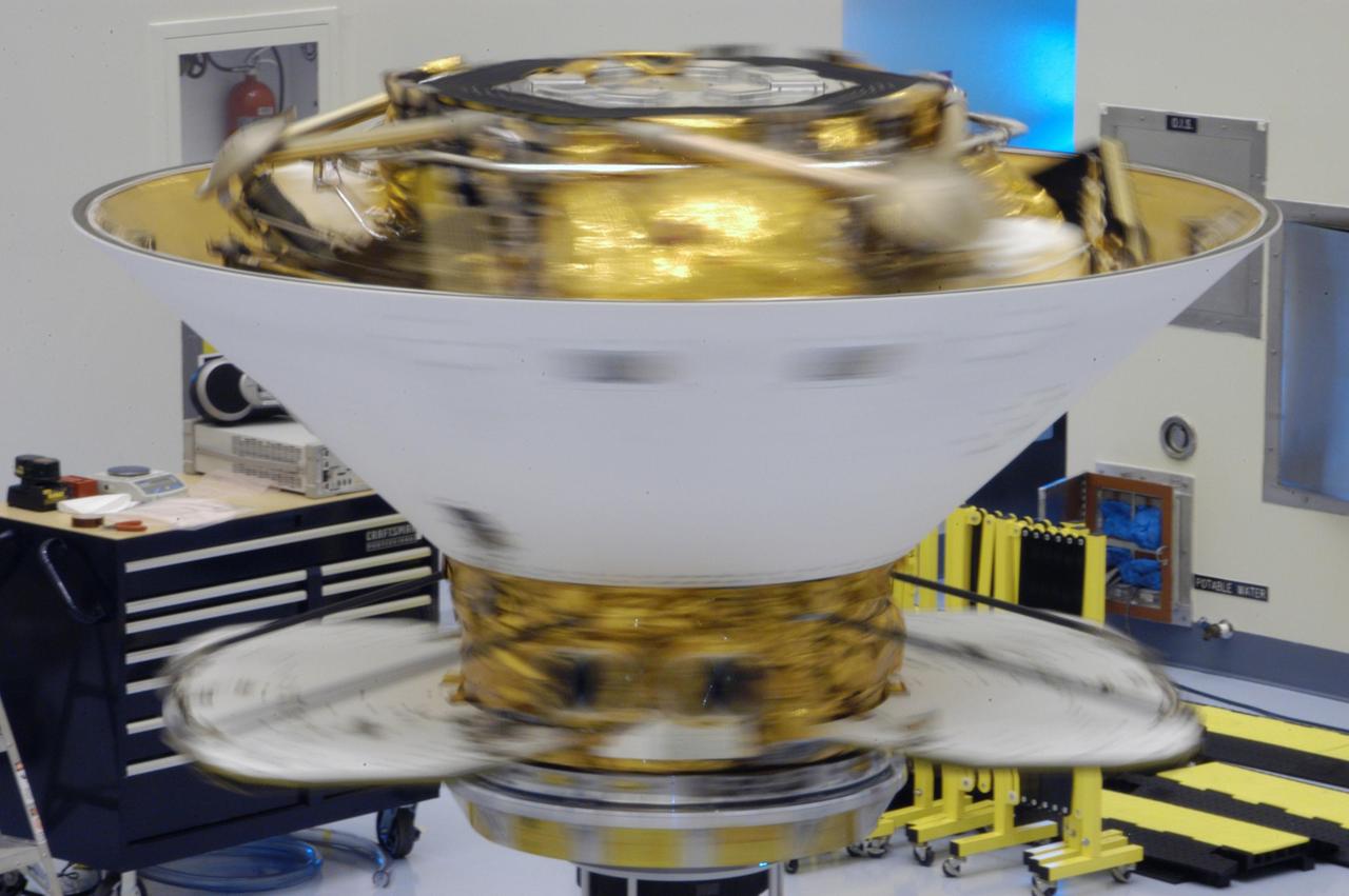
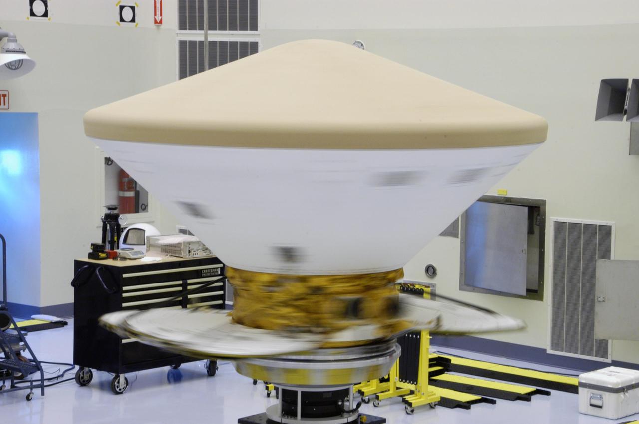
KENNEDY SPACE CENTER, FLA. -- In the Payload Hazardous Servicing Facility, the Phoenix Mars Lander spacecraft undergoes spin testing. The Phoenix mission is the first project in NASA's first openly competed program of Mars Scout missions. Phoenix will land in icy soils near the north polar permanent ice cap of Mars and explore the history of the water in these soils and any associated rocks, while monitoring polar climate. Landing is planned in May 2008 on arctic ground where a mission currently in orbit, Mars Odyssey, has detected high concentrations of ice just beneath the top layer of soil. It will serve as NASA's first exploration of a potential modern habitat on Mars and open the door to a renewed search for carbon-bearing compounds, last attempted with NASA's Viking missions in the 1970s. A stereo color camera and a weather station will study the surrounding environment while the other instruments check excavated soil samples for water, organic chemicals and conditions that could indicate whether the site was ever hospitable to life. Microscopes can reveal features as small as one one-thousandth the width of a human hair. Launch of Phoenix aboard a Delta II rocket is targeted for Aug. 3 from Cape Canaveral Air Force Station in Florida. Photo credit: NASA/George Shelton

In the Payload Hazardous Servicing Facility, technicians attach a crane to the Phoenix Mars Lander spacecraft. The crane will be used to remove the heat shield from around the Phoenix. The Phoenix mission is the first project in NASA's first openly competed program of Mars Scout missions. Phoenix will land in icy soils near the north polar permanent ice cap of Mars and explore the history of the water in these soils and any associated rocks, while monitoring polar climate. Landing is planned in May 2008 on arctic ground where a mission currently in orbit, Mars Odyssey, has detected high concentrations of ice just beneath the top layer of soil. It will serve as NASA's first exploration of a potential modern habitat on Mars and open the door to a renewed search for carbon-bearing compounds, last attempted with NASA’s Viking missions in the 1970s. A stereo color camera and a weather station will study the surrounding environment while the other instruments check excavated soil samples for water, organic chemicals and conditions that could indicate whether the site was ever hospitable to life. Microscopes can reveal features as small as one one-thousandth the width of a human hair. Launch of Phoenix aboard a Delta II rocket is targeted for Aug. 3 from Cape Canaveral Air Force Station in Florida.

In the Payload Hazardous Servicing Facility, technicians prepare to install the heat shield on the Phoenix Mars Lander spacecraft. The Phoenix mission is the first project in NASA's first openly competed program of Mars Scout missions. Phoenix will land in icy soils near the north polar permanent ice cap of Mars and explore the history of the water in these soils and any associated rocks, while monitoring polar climate. Landing is planned in May 2008 on arctic ground where a mission currently in orbit, Mars Odyssey, has detected high concentrations of ice just beneath the top layer of soil. It will serve as NASA's first exploration of a potential modern habitat on Mars and open the door to a renewed search for carbon-bearing compounds, last attempted with NASA's Viking missions in the 1970s. A stereo color camera and a weather station will study the surrounding environment while the other instruments check excavated soil samples for water, organic chemicals and conditions that could indicate whether the site was ever hospitable to life. Microscopes can reveal features as small as one one-thousandth the width of a human hair. Launch of Phoenix aboard a Delta II rocket is targeted for Aug. 3 from Cape Canaveral Air Force Station in Florida.
KENNEDY SPACE CENTER, FLA. -- In the Payload Hazardous Servicing Facility, technicians attach a crane to the Phoenix Mars Lander spacecraft. The crane will be used to remove the heat shield from around the Phoenix. The Phoenix mission is the first project in NASA's first openly competed program of Mars Scout missions. Phoenix will land in icy soils near the north polar permanent ice cap of Mars and explore the history of the water in these soils and any associated rocks, while monitoring polar climate. Landing is planned in May 2008 on arctic ground where a mission currently in orbit, Mars Odyssey, has detected high concentrations of ice just beneath the top layer of soil. It will serve as NASA's first exploration of a potential modern habitat on Mars and open the door to a renewed search for carbon-bearing compounds, last attempted with NASA’s Viking missions in the 1970s. A stereo color camera and a weather station will study the surrounding environment while the other instruments check excavated soil samples for water, organic chemicals and conditions that could indicate whether the site was ever hospitable to life. Microscopes can reveal features as small as one one-thousandth the width of a human hair. Launch of Phoenix aboard a Delta II rocket is targeted for Aug. 3 from Cape Canaveral Air Force Station in Florida. Photo credit: NASA/George Shelton
KENNEDY SPACE CENTER, FLA. -- This closeup shows the Phoenix Mars Lander spacecraft nestled inside the backshell. The spacecraft is ready for spin testing on the spin table to which it is attached in the Payload Hazardous Servicing Facility. The Phoenix mission is the first project in NASA's first openly competed program of Mars Scout missions. Phoenix will land in icy soils near the north polar permanent ice cap of Mars and explore the history of the water in these soils and any associated rocks, while monitoring polar climate. Landing is planned in May 2008 on arctic ground where a mission currently in orbit, Mars Odyssey, has detected high concentrations of ice just beneath the top layer of soil. It will serve as NASA's first exploration of a potential modern habitat on Mars and open the door to a renewed search for carbon-bearing compounds, last attempted with NASA’s Viking missions in the 1970s. A stereo color camera and a weather station will study the surrounding environment while the other instruments check excavated soil samples for water, organic chemicals and conditions that could indicate whether the site was ever hospitable to life. Microscopes can reveal features as small as one one-thousandth the width of a human hair. Launch of Phoenix aboard a Delta II rocket is targeted for Aug. 3 from Cape Canaveral Air Force Station in Florida. Photo credit: NASA/George Shelton
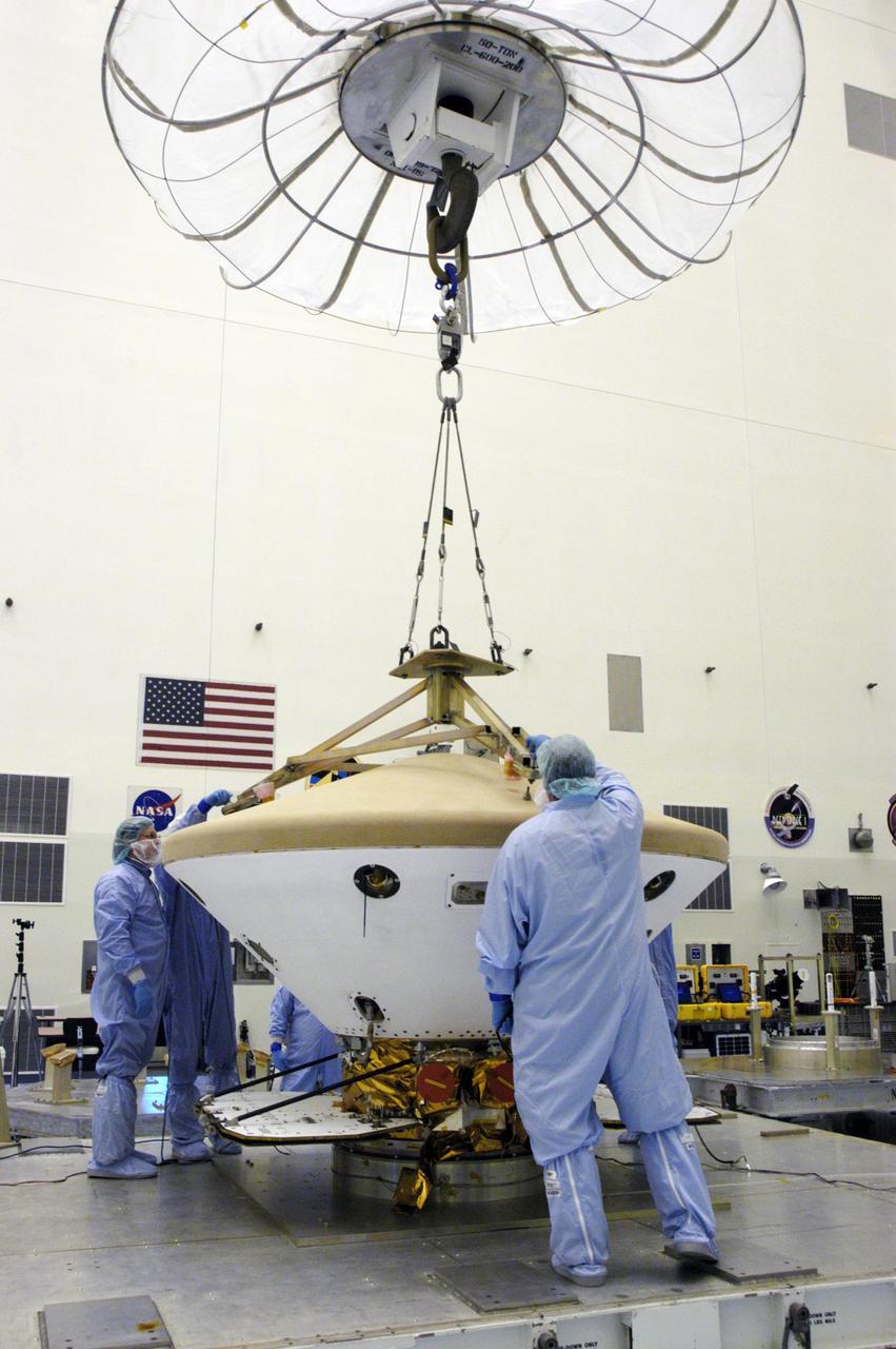
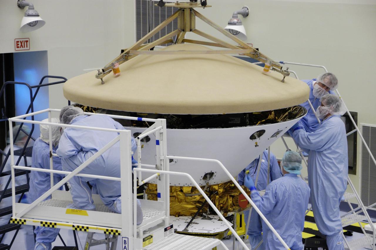
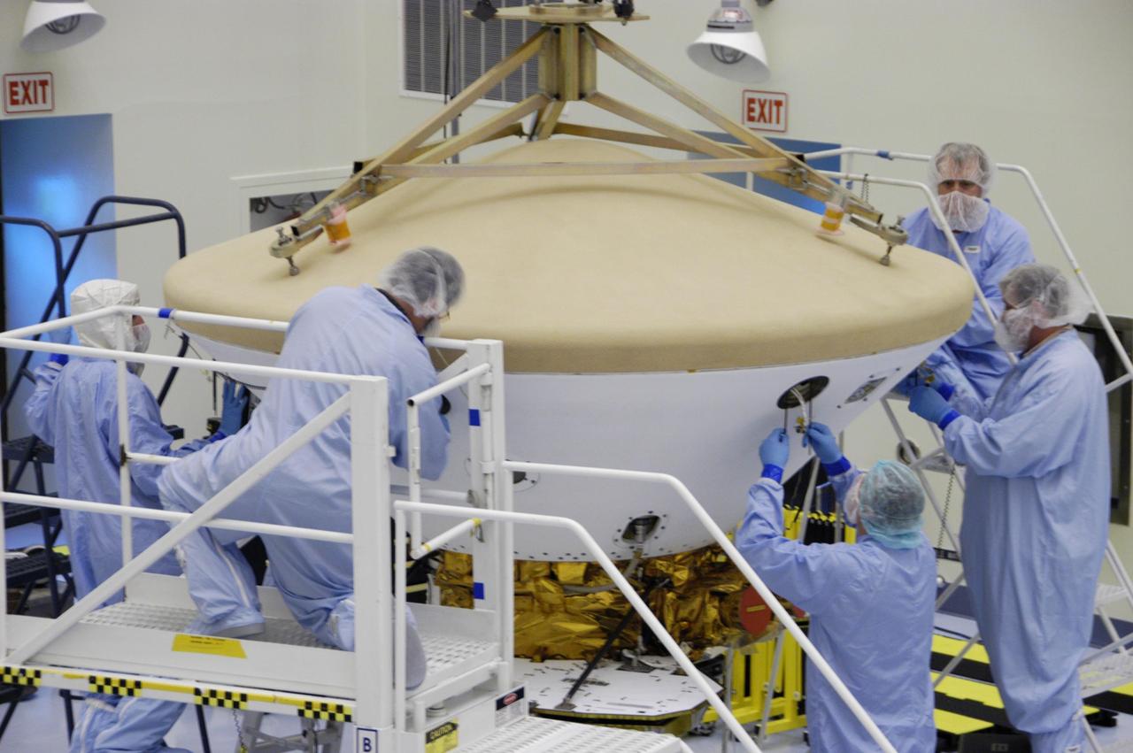
In the Payload Hazardous Servicing Facility, the Phoenix Mars Lander (foreground) can be seen inside the backshell. In the background, workers are helping place the heat shield, just removed from the Phoenix, onto a platform. The Phoenix mission is the first project in NASA's first openly competed program of Mars Scout missions. Phoenix will land in icy soils near the north polar permanent ice cap of Mars and explore the history of the water in these soils and any associated rocks, while monitoring polar climate. Landing is planned in May 2008 on arctic ground where a mission currently in orbit, Mars Odyssey, has detected high concentrations of ice just beneath the top layer of soil. It will serve as NASA's first exploration of a potential modern habitat on Mars and open the door to a renewed search for carbon-bearing compounds, last attempted with NASA’s Viking missions in the 1970s. A stereo color camera and a weather station will study the surrounding environment while the other instruments check excavated soil samples for water, organic chemicals and conditions that could indicate whether the site was ever hospitable to life. Microscopes can reveal features as small as one one-thousandth the width of a human hair. Launch of Phoenix aboard a Delta II rocket is targeted for Aug. 3 from Cape Canaveral Air Force Station in Florida.

An overhead crane lowers the backshell with the Phoenix Mars Lander inside toward a spin table for spin testing in the Payload Hazardous Servicing Facility. The Phoenix mission is the first project in NASA's first openly competed program of Mars Scout missions. Phoenix will land in icy soils near the north polar permanent ice cap of Mars and explore the history of the water in these soils and any associated rocks, while monitoring polar climate. Landing is planned in May 2008 on arctic ground where a mission currently in orbit, Mars Odyssey, has detected high concentrations of ice just beneath the top layer of soil. It will serve as NASA's first exploration of a potential modern habitat on Mars and open the door to a renewed search for carbon-bearing compounds, last attempted with NASA’s Viking missions in the 1970s. A stereo color camera and a weather station will study the surrounding environment while the other instruments check excavated soil samples for water, organic chemicals and conditions that could indicate whether the site was ever hospitable to life. Microscopes can reveal features as small as one one-thousandth the width of a human hair. Launch of Phoenix aboard a Delta II rocket is targeted for Aug. 3 from Cape Canaveral Air Force Station in Florida.
In the Payload Hazardous Servicing Facility, workers help guide the heat shield onto a platform. The heat shield was removed from the Phoenix Mars Lander spacecraft.. The Phoenix mission is the first project in NASA's first openly competed program of Mars Scout missions. Phoenix will land in icy soils near the north polar permanent ice cap of Mars and explore the history of the water in these soils and any associated rocks, while monitoring polar climate. Landing is planned in May 2008 on arctic ground where a mission currently in orbit, Mars Odyssey, has detected high concentrations of ice just beneath the top layer of soil. It will serve as NASA's first exploration of a potential modern habitat on Mars and open the door to a renewed search for carbon-bearing compounds, last attempted with NASA’s Viking missions in the 1970s. A stereo color camera and a weather station will study the surrounding environment while the other instruments check excavated soil samples for water, organic chemicals and conditions that could indicate whether the site was ever hospitable to life. Microscopes can reveal features as small as one one-thousandth the width of a human hair. Launch of Phoenix aboard a Delta II rocket is targeted for Aug. 3 from Cape Canaveral Air Force Station in Florida.
In the Payload Hazardous Servicing Facility, the heat shield for the Phoenix Mars Lander is moved into position for installation on the spacecraft. The Phoenix mission is the first project in NASA's first openly competed program of Mars Scout missions. Phoenix will land in icy soils near the north polar permanent ice cap of Mars and explore the history of the water in these soils and any associated rocks, while monitoring polar climate. Landing is planned in May 2008 on arctic ground where a mission currently in orbit, Mars Odyssey, has detected high concentrations of ice just beneath the top layer of soil. It will serve as NASA's first exploration of a potential modern habitat on Mars and open the door to a renewed search for carbon-bearing compounds, last attempted with NASA's Viking missions in the 1970s. A stereo color camera and a weather station will study the surrounding environment while the other instruments check excavated soil samples for water, organic chemicals and conditions that could indicate whether the site was ever hospitable to life. Microscopes can reveal features as small as one one-thousandth the width of a human hair. Launch of Phoenix aboard a Delta II rocket is targeted for Aug. 3 from Cape Canaveral Air Force Station in Florida.

KENNEDY SPACE CENTER, FLA. -- In the Payload Hazardous Servicing Facility, workers help guide the heat shield onto a platform. The heat shield was removed from the Phoenix Mars Lander spacecraft.. The Phoenix mission is the first project in NASA's first openly competed program of Mars Scout missions. Phoenix will land in icy soils near the north polar permanent ice cap of Mars and explore the history of the water in these soils and any associated rocks, while monitoring polar climate. Landing is planned in May 2008 on arctic ground where a mission currently in orbit, Mars Odyssey, has detected high concentrations of ice just beneath the top layer of soil. It will serve as NASA's first exploration of a potential modern habitat on Mars and open the door to a renewed search for carbon-bearing compounds, last attempted with NASA’s Viking missions in the 1970s. A stereo color camera and a weather station will study the surrounding environment while the other instruments check excavated soil samples for water, organic chemicals and conditions that could indicate whether the site was ever hospitable to life. Microscopes can reveal features as small as one one-thousandth the width of a human hair. Launch of Phoenix aboard a Delta II rocket is targeted for Aug. 3 from Cape Canaveral Air Force Station in Florida. Photo credit: NASA/George Shelton
KENNEDY SPACE CENTER, FLA. -- In the Payload Hazardous Servicing Facility, an overhead crane lifts the heat shield from the Phoenix Mars Lander spacecraft. The Phoenix mission is the first project in NASA's first openly competed program of Mars Scout missions. Phoenix will land in icy soils near the north polar permanent ice cap of Mars and explore the history of the water in these soils and any associated rocks, while monitoring polar climate. Landing is planned in May 2008 on arctic ground where a mission currently in orbit, Mars Odyssey, has detected high concentrations of ice just beneath the top layer of soil. It will serve as NASA's first exploration of a potential modern habitat on Mars and open the door to a renewed search for carbon-bearing compounds, last attempted with NASA’s Viking missions in the 1970s. A stereo color camera and a weather station will study the surrounding environment while the other instruments check excavated soil samples for water, organic chemicals and conditions that could indicate whether the site was ever hospitable to life. Microscopes can reveal features as small as one one-thousandth the width of a human hair. Launch of Phoenix aboard a Delta II rocket is targeted for Aug. 3 from Cape Canaveral Air Force Station in Florida. Photo credit: NASA/George Shelton

This closeup shows the spin test of the Phoenix Mars Lander in the Payload Hazardous Servicing Facility. The Phoenix mission is the first project in NASA's first openly competed program of Mars Scout missions. Phoenix will land in icy soils near the north polar permanent ice cap of Mars and explore the history of the water in these soils and any associated rocks, while monitoring polar climate. Landing is planned in May 2008 on arctic ground where a mission currently in orbit, Mars Odyssey, has detected high concentrations of ice just beneath the top layer of soil. It will serve as NASA's first exploration of a potential modern habitat on Mars and open the door to a renewed search for carbon-bearing compounds, last attempted with NASA’s Viking missions in the 1970s. A stereo color camera and a weather station will study the surrounding environment while the other instruments check excavated soil samples for water, organic chemicals and conditions that could indicate whether the site was ever hospitable to life. Microscopes can reveal features as small as one one-thousandth the width of a human hair. Launch of Phoenix aboard a Delta II rocket is targeted for Aug. 3 from Cape Canaveral Air Force Station in Florida.

In the Payload Hazardous Servicing Facility, technicians install the heat shield on the Phoenix Mars Lander spacecraft. The Phoenix mission is the first project in NASA's first openly competed program of Mars Scout missions. Phoenix will land in icy soils near the north polar permanent ice cap of Mars and explore the history of the water in these soils and any associated rocks, while monitoring polar climate. Landing is planned in May 2008 on arctic ground where a mission currently in orbit, Mars Odyssey, has detected high concentrations of ice just beneath the top layer of soil. It will serve as NASA's first exploration of a potential modern habitat on Mars and open the door to a renewed search for carbon-bearing compounds, last attempted with NASA's Viking missions in the 1970s. A stereo color camera and a weather station will study the surrounding environment while the other instruments check excavated soil samples for water, organic chemicals and conditions that could indicate whether the site was ever hospitable to life. Microscopes can reveal features as small as one one-thousandth the width of a human hair. Launch of Phoenix aboard a Delta II rocket is targeted for Aug. 3 from Cape Canaveral Air Force Station in Florida.
KENNEDY SPACE CENTER, FLA. -- In the Payload Hazardous Servicing Facility, the Phoenix Mars Lander (foreground) can be seen inside the backshell. In the background, workers are helping place the heat shield, just removed from the Phoenix, onto a platform. The Phoenix mission is the first project in NASA's first openly competed program of Mars Scout missions. Phoenix will land in icy soils near the north polar permanent ice cap of Mars and explore the history of the water in these soils and any associated rocks, while monitoring polar climate. Landing is planned in May 2008 on arctic ground where a mission currently in orbit, Mars Odyssey, has detected high concentrations of ice just beneath the top layer of soil. It will serve as NASA's first exploration of a potential modern habitat on Mars and open the door to a renewed search for carbon-bearing compounds, last attempted with NASA’s Viking missions in the 1970s. A stereo color camera and a weather station will study the surrounding environment while the other instruments check excavated soil samples for water, organic chemicals and conditions that could indicate whether the site was ever hospitable to life. Microscopes can reveal features as small as one one-thousandth the width of a human hair. Launch of Phoenix aboard a Delta II rocket is targeted for Aug. 3 from Cape Canaveral Air Force Station in Florida. Photo credit: NASA/George Shelton
KENNEDY SPACE CENTER, FLA. -- This closeup shows the spin test of the Phoenix Mars Lander in the Payload Hazardous Servicing Facility. The Phoenix mission is the first project in NASA's first openly competed program of Mars Scout missions. Phoenix will land in icy soils near the north polar permanent ice cap of Mars and explore the history of the water in these soils and any associated rocks, while monitoring polar climate. Landing is planned in May 2008 on arctic ground where a mission currently in orbit, Mars Odyssey, has detected high concentrations of ice just beneath the top layer of soil. It will serve as NASA's first exploration of a potential modern habitat on Mars and open the door to a renewed search for carbon-bearing compounds, last attempted with NASA’s Viking missions in the 1970s. A stereo color camera and a weather station will study the surrounding environment while the other instruments check excavated soil samples for water, organic chemicals and conditions that could indicate whether the site was ever hospitable to life. Microscopes can reveal features as small as one one-thousandth the width of a human hair. Launch of Phoenix aboard a Delta II rocket is targeted for Aug. 3 from Cape Canaveral Air Force Station in Florida. Photo credit: NASA/George Shelton
KENNEDY SPACE CENTER, FLA. -- An overhead crane lowers the backshell with the Phoenix Mars Lander inside toward a spin table for spin testing in the Payload Hazardous Servicing Facility. The Phoenix mission is the first project in NASA's first openly competed program of Mars Scout missions. Phoenix will land in icy soils near the north polar permanent ice cap of Mars and explore the history of the water in these soils and any associated rocks, while monitoring polar climate. Landing is planned in May 2008 on arctic ground where a mission currently in orbit, Mars Odyssey, has detected high concentrations of ice just beneath the top layer of soil. It will serve as NASA's first exploration of a potential modern habitat on Mars and open the door to a renewed search for carbon-bearing compounds, last attempted with NASA’s Viking missions in the 1970s. A stereo color camera and a weather station will study the surrounding environment while the other instruments check excavated soil samples for water, organic chemicals and conditions that could indicate whether the site was ever hospitable to life. Microscopes can reveal features as small as one one-thousandth the width of a human hair. Launch of Phoenix aboard a Delta II rocket is targeted for Aug. 3 from Cape Canaveral Air Force Station in Florida. Photo credit: NASA/George Shelton
KENNEDY SPACE CENTER, FLA. -- In the Payload Hazardous Servicing Facility, technicians secure the backshell with the Phoenix Mars Lander inside onto a spin table for spin testing. The Phoenix mission is the first project in NASA's first openly competed program of Mars Scout missions. Phoenix will land in icy soils near the north polar permanent ice cap of Mars and explore the history of the water in these soils and any associated rocks, while monitoring polar climate. Landing is planned in May 2008 on arctic ground where a mission currently in orbit, Mars Odyssey, has detected high concentrations of ice just beneath the top layer of soil. It will serve as NASA's first exploration of a potential modern habitat on Mars and open the door to a renewed search for carbon-bearing compounds, last attempted with NASA’s Viking missions in the 1970s. A stereo color camera and a weather station will study the surrounding environment while the other instruments check excavated soil samples for water, organic chemicals and conditions that could indicate whether the site was ever hospitable to life. Microscopes can reveal features as small as one one-thousandth the width of a human hair. Launch of Phoenix aboard a Delta II rocket is targeted for Aug. 3 from Cape Canaveral Air Force Station in Florida. Photo credit: NASA/George Shelton

This closeup shows the Phoenix Mars Lander spacecraft nestled inside the backshell. The spacecraft is ready for spin testing on the spin table to which it is attached in the Payload Hazardous Servicing Facility. The Phoenix mission is the first project in NASA's first openly competed program of Mars Scout missions. Phoenix will land in icy soils near the north polar permanent ice cap of Mars and explore the history of the water in these soils and any associated rocks, while monitoring polar climate. Landing is planned in May 2008 on arctic ground where a mission currently in orbit, Mars Odyssey, has detected high concentrations of ice just beneath the top layer of soil. It will serve as NASA's first exploration of a potential modern habitat on Mars and open the door to a renewed search for carbon-bearing compounds, last attempted with NASA’s Viking missions in the 1970s. A stereo color camera and a weather station will study the surrounding environment while the other instruments check excavated soil samples for water, organic chemicals and conditions that could indicate whether the site was ever hospitable to life. Microscopes can reveal features as small as one one-thousandth the width of a human hair. Launch of Phoenix aboard a Delta II rocket is targeted for Aug. 3 from Cape Canaveral Air Force Station in Florida.
In the Payload Hazardous Servicing Facility, workers watch as an overhead crane lowers the heat shield toward a platform. The heat shield was removed from the Phoenix Mars Lander spacecraft. The Phoenix mission is the first project in NASA's first openly competed program of Mars Scout missions. Phoenix will land in icy soils near the north polar permanent ice cap of Mars and explore the history of the water in these soils and any associated rocks, while monitoring polar climate. Landing is planned in May 2008 on arctic ground where a mission currently in orbit, Mars Odyssey, has detected high concentrations of ice just beneath the top layer of soil. It will serve as NASA's first exploration of a potential modern habitat on Mars and open the door to a renewed search for carbon-bearing compounds, last attempted with NASA’s Viking missions in the 1970s. A stereo color camera and a weather station will study the surrounding environment while the other instruments check excavated soil samples for water, organic chemicals and conditions that could indicate whether the site was ever hospitable to life. Microscopes can reveal features as small as one one-thousandth the width of a human hair. Launch of Phoenix aboard a Delta II rocket is targeted for Aug. 3 from Cape Canaveral Air Force Station in Florida.
KENNEDY SPACE CENTER, FLA. -- An overhead crane lowers the backshell with the Phoenix Mars Lander inside onto a spin table for spin testing in the Payload Hazardous Servicing Facility. The Phoenix mission is the first project in NASA's first openly competed program of Mars Scout missions. Phoenix will land in icy soils near the north polar permanent ice cap of Mars and explore the history of the water in these soils and any associated rocks, while monitoring polar climate. Landing is planned in May 2008 on arctic ground where a mission currently in orbit, Mars Odyssey, has detected high concentrations of ice just beneath the top layer of soil. It will serve as NASA's first exploration of a potential modern habitat on Mars and open the door to a renewed search for carbon-bearing compounds, last attempted with NASA’s Viking missions in the 1970s. A stereo color camera and a weather station will study the surrounding environment while the other instruments check excavated soil samples for water, organic chemicals and conditions that could indicate whether the site was ever hospitable to life. Microscopes can reveal features as small as one one-thousandth the width of a human hair. Launch of Phoenix aboard a Delta II rocket is targeted for Aug. 3 from Cape Canaveral Air Force Station in Florida. Photo credit: NASA/George Shelton
KENNEDY SPACE CENTER, FLA. -- In the Payload Hazardous Servicing Facility, technicians prepare to install the heat shield on the Phoenix Mars Lander spacecraft. The Phoenix mission is the first project in NASA's first openly competed program of Mars Scout missions. Phoenix will land in icy soils near the north polar permanent ice cap of Mars and explore the history of the water in these soils and any associated rocks, while monitoring polar climate. Landing is planned in May 2008 on arctic ground where a mission currently in orbit, Mars Odyssey, has detected high concentrations of ice just beneath the top layer of soil. It will serve as NASA's first exploration of a potential modern habitat on Mars and open the door to a renewed search for carbon-bearing compounds, last attempted with NASA's Viking missions in the 1970s. A stereo color camera and a weather station will study the surrounding environment while the other instruments check excavated soil samples for water, organic chemicals and conditions that could indicate whether the site was ever hospitable to life. Microscopes can reveal features as small as one one-thousandth the width of a human hair. Launch of Phoenix aboard a Delta II rocket is targeted for Aug. 3 from Cape Canaveral Air Force Station in Florida. Photo credit: NASA/George Shelton
KENNEDY SPACE CENTER, FLA. -- In the Payload Hazardous Servicing Facility, technicians install the heat shield on the Phoenix Mars Lander spacecraft. The Phoenix mission is the first project in NASA's first openly competed program of Mars Scout missions. Phoenix will land in icy soils near the north polar permanent ice cap of Mars and explore the history of the water in these soils and any associated rocks, while monitoring polar climate. Landing is planned in May 2008 on arctic ground where a mission currently in orbit, Mars Odyssey, has detected high concentrations of ice just beneath the top layer of soil. It will serve as NASA's first exploration of a potential modern habitat on Mars and open the door to a renewed search for carbon-bearing compounds, last attempted with NASA's Viking missions in the 1970s. A stereo color camera and a weather station will study the surrounding environment while the other instruments check excavated soil samples for water, organic chemicals and conditions that could indicate whether the site was ever hospitable to life. Microscopes can reveal features as small as one one-thousandth the width of a human hair. Launch of Phoenix aboard a Delta II rocket is targeted for Aug. 3 from Cape Canaveral Air Force Station in Florida. Photo credit: NASA/George Shelton

In the Payload Hazardous Servicing Facility, an overhead crane moves the heat shield toward a platform at left. The heat shield was removed from the Phoenix Mars Lander spacecraft at right. The Phoenix mission is the first project in NASA's first openly competed program of Mars Scout missions. Phoenix will land in icy soils near the north polar permanent ice cap of Mars and explore the history of the water in these soils and any associated rocks, while monitoring polar climate. Landing is planned in May 2008 on arctic ground where a mission currently in orbit, Mars Odyssey, has detected high concentrations of ice just beneath the top layer of soil. It will serve as NASA's first exploration of a potential modern habitat on Mars and open the door to a renewed search for carbon-bearing compounds, last attempted with NASA’s Viking missions in the 1970s. A stereo color camera and a weather station will study the surrounding environment while the other instruments check excavated soil samples for water, organic chemicals and conditions that could indicate whether the site was ever hospitable to life. Microscopes can reveal features as small as one one-thousandth the width of a human hair. Launch of Phoenix aboard a Delta II rocket is targeted for Aug. 3 from Cape Canaveral Air Force Station in Florida.
KENNEDY SPACE CENTER, FLA. -- In the Payload Hazardous Servicing Facility, technicians complete the installation of the heat shield on the Phoenix Mars Lander spacecraft. The Phoenix mission is the first project in NASA's first openly competed program of Mars Scout missions. Phoenix will land in icy soils near the north polar permanent ice cap of Mars and explore the history of the water in these soils and any associated rocks, while monitoring polar climate. Landing is planned in May 2008 on arctic ground where a mission currently in orbit, Mars Odyssey, has detected high concentrations of ice just beneath the top layer of soil. It will serve as NASA's first exploration of a potential modern habitat on Mars and open the door to a renewed search for carbon-bearing compounds, last attempted with NASA's Viking missions in the 1970s. A stereo color camera and a weather station will study the surrounding environment while the other instruments check excavated soil samples for water, organic chemicals and conditions that could indicate whether the site was ever hospitable to life. Microscopes can reveal features as small as one one-thousandth the width of a human hair. Launch of Phoenix aboard a Delta II rocket is targeted for Aug. 3 from Cape Canaveral Air Force Station in Florida. Photo credit: NASA/George Shelton

In the Payload Hazardous Servicing Facility, technicians complete the installation of the heat shield on the Phoenix Mars Lander spacecraft. The Phoenix mission is the first project in NASA's first openly competed program of Mars Scout missions. Phoenix will land in icy soils near the north polar permanent ice cap of Mars and explore the history of the water in these soils and any associated rocks, while monitoring polar climate. Landing is planned in May 2008 on arctic ground where a mission currently in orbit, Mars Odyssey, has detected high concentrations of ice just beneath the top layer of soil. It will serve as NASA's first exploration of a potential modern habitat on Mars and open the door to a renewed search for carbon-bearing compounds, last attempted with NASA's Viking missions in the 1970s. A stereo color camera and a weather station will study the surrounding environment while the other instruments check excavated soil samples for water, organic chemicals and conditions that could indicate whether the site was ever hospitable to life. Microscopes can reveal features as small as one one-thousandth the width of a human hair. Launch of Phoenix aboard a Delta II rocket is targeted for Aug. 3 from Cape Canaveral Air Force Station in Florida.
KENNEDY SPACE CENTER, FLA. -- In the Payload Hazardous Servicing Facility, technicians lower a crane over the Phoenix Mars Lander spacecraft. The crane will be used to remove the heat shield from around the Phoenix. The Phoenix mission is the first project in NASA's first openly competed program of Mars Scout missions. Phoenix will land in icy soils near the north polar permanent ice cap of Mars and explore the history of the water in these soils and any associated rocks, while monitoring polar climate. Landing is planned in May 2008 on arctic ground where a mission currently in orbit, Mars Odyssey, has detected high concentrations of ice just beneath the top layer of soil. It will serve as NASA's first exploration of a potential modern habitat on Mars and open the door to a renewed search for carbon-bearing compounds, last attempted with NASA’s Viking missions in the 1970s. A stereo color camera and a weather station will study the surrounding environment while the other instruments check excavated soil samples for water, organic chemicals and conditions that could indicate whether the site was ever hospitable to life. Microscopes can reveal features as small as one one-thousandth the width of a human hair. Launch of Phoenix aboard a Delta II rocket is targeted for Aug. 3 from Cape Canaveral Air Force Station in Florida. Photo credit: NASA/George Shelton
KENNEDY SPACE CENTER, FLA. -- In the Payload Hazardous Servicing Facility, the Phoenix Mars Lander spacecraft undergoes spin testing. The Phoenix mission is the first project in NASA's first openly competed program of Mars Scout missions. Phoenix will land in icy soils near the north polar permanent ice cap of Mars and explore the history of the water in these soils and any associated rocks, while monitoring polar climate. Landing is planned in May 2008 on arctic ground where a mission currently in orbit, Mars Odyssey, has detected high concentrations of ice just beneath the top layer of soil. It will serve as NASA's first exploration of a potential modern habitat on Mars and open the door to a renewed search for carbon-bearing compounds, last attempted with NASA's Viking missions in the 1970s. A stereo color camera and a weather station will study the surrounding environment while the other instruments check excavated soil samples for water, organic chemicals and conditions that could indicate whether the site was ever hospitable to life. Microscopes can reveal features as small as one one-thousandth the width of a human hair. Launch of Phoenix aboard a Delta II rocket is targeted for Aug. 3 from Cape Canaveral Air Force Station in Florida. Photo credit: NASA/George Shelton
KENNEDY SPACE CENTER, FLA. -- In the Payload Hazardous Servicing Facility, the heat shield for the Phoenix Mars Lander is moved into position for installation on the spacecraft. The Phoenix mission is the first project in NASA's first openly competed program of Mars Scout missions. Phoenix will land in icy soils near the north polar permanent ice cap of Mars and explore the history of the water in these soils and any associated rocks, while monitoring polar climate. Landing is planned in May 2008 on arctic ground where a mission currently in orbit, Mars Odyssey, has detected high concentrations of ice just beneath the top layer of soil. It will serve as NASA's first exploration of a potential modern habitat on Mars and open the door to a renewed search for carbon-bearing compounds, last attempted with NASA's Viking missions in the 1970s. A stereo color camera and a weather station will study the surrounding environment while the other instruments check excavated soil samples for water, organic chemicals and conditions that could indicate whether the site was ever hospitable to life. Microscopes can reveal features as small as one one-thousandth the width of a human hair. Launch of Phoenix aboard a Delta II rocket is targeted for Aug. 3 from Cape Canaveral Air Force Station in Florida. Photo credit: NASA/George Shelton

In the Payload Hazardous Servicing Facility, the Phoenix Mars Lander spacecraft undergoes spin testing. The Phoenix mission is the first project in NASA's first openly competed program of Mars Scout missions. Phoenix will land in icy soils near the north polar permanent ice cap of Mars and explore the history of the water in these soils and any associated rocks, while monitoring polar climate. Landing is planned in May 2008 on arctic ground where a mission currently in orbit, Mars Odyssey, has detected high concentrations of ice just beneath the top layer of soil. It will serve as NASA's first exploration of a potential modern habitat on Mars and open the door to a renewed search for carbon-bearing compounds, last attempted with NASA's Viking missions in the 1970s. A stereo color camera and a weather station will study the surrounding environment while the other instruments check excavated soil samples for water, organic chemicals and conditions that could indicate whether the site was ever hospitable to life. Microscopes can reveal features as small as one one-thousandth the width of a human hair. Launch of Phoenix aboard a Delta II rocket is targeted for Aug. 3 from Cape Canaveral Air Force Station in Florida.
KENNEDY SPACE CENTER, FLA. -- In the Payload Hazardous Servicing Facility, the Phoenix Mars Lander spacecraft undergoes spin testing. The Phoenix mission is the first project in NASA's first openly competed program of Mars Scout missions. Phoenix will land in icy soils near the north polar permanent ice cap of Mars and explore the history of the water in these soils and any associated rocks, while monitoring polar climate. Landing is planned in May 2008 on arctic ground where a mission currently in orbit, Mars Odyssey, has detected high concentrations of ice just beneath the top layer of soil. It will serve as NASA's first exploration of a potential modern habitat on Mars and open the door to a renewed search for carbon-bearing compounds, last attempted with NASA’s Viking missions in the 1970s. A stereo color camera and a weather station will study the surrounding environment while the other instruments check excavated soil samples for water, organic chemicals and conditions that could indicate whether the site was ever hospitable to life. Microscopes can reveal features as small as one one-thousandth the width of a human hair. Launch of Phoenix aboard a Delta II rocket is targeted for Aug. 3 from Cape Canaveral Air Force Station in Florida. Photo credit: NASA/George Shelton

KENNEDY SPACE CENTER, FLA. -- In the Payload Hazardous Servicing Facility, the Phoenix Mars Lander (foreground) can be seen inside the backshell. In the background, workers are helping place the heat shield, just removed from the Phoenix, onto a platform. The Phoenix mission is the first project in NASA's first openly competed program of Mars Scout missions. Phoenix will land in icy soils near the north polar permanent ice cap of Mars and explore the history of the water in these soils and any associated rocks, while monitoring polar climate. Landing is planned in May 2008 on arctic ground where a mission currently in orbit, Mars Odyssey, has detected high concentrations of ice just beneath the top layer of soil. It will serve as NASA's first exploration of a potential modern habitat on Mars and open the door to a renewed search for carbon-bearing compounds, last attempted with NASA’s Viking missions in the 1970s. A stereo color camera and a weather station will study the surrounding environment while the other instruments check excavated soil samples for water, organic chemicals and conditions that could indicate whether the site was ever hospitable to life. Microscopes can reveal features as small as one one-thousandth the width of a human hair. Launch of Phoenix aboard a Delta II rocket is targeted for Aug. 3 from Cape Canaveral Air Force Station in Florida. Photo credit: NASA/George Shelton
KENNEDY SPACE CENTER, FLA. -- In the Payload Hazardous Servicing Facility, workers watch as an overhead crane lowers the heat shield toward a platform. The heat shield was removed from the Phoenix Mars Lander spacecraft. The Phoenix mission is the first project in NASA's first openly competed program of Mars Scout missions. Phoenix will land in icy soils near the north polar permanent ice cap of Mars and explore the history of the water in these soils and any associated rocks, while monitoring polar climate. Landing is planned in May 2008 on arctic ground where a mission currently in orbit, Mars Odyssey, has detected high concentrations of ice just beneath the top layer of soil. It will serve as NASA's first exploration of a potential modern habitat on Mars and open the door to a renewed search for carbon-bearing compounds, last attempted with NASA’s Viking missions in the 1970s. A stereo color camera and a weather station will study the surrounding environment while the other instruments check excavated soil samples for water, organic chemicals and conditions that could indicate whether the site was ever hospitable to life. Microscopes can reveal features as small as one one-thousandth the width of a human hair. Launch of Phoenix aboard a Delta II rocket is targeted for Aug. 3 from Cape Canaveral Air Force Station in Florida. Photo credit: NASA/George Shelton
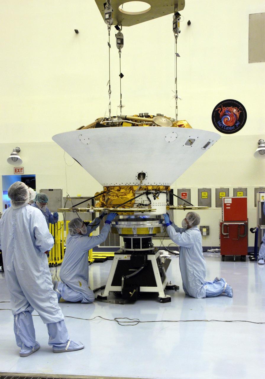
In the Payload Hazardous Servicing Facility, technicians secure the backshell with the Phoenix Mars Lander inside onto a spin table for spin testing. The Phoenix mission is the first project in NASA's first openly competed program of Mars Scout missions. Phoenix will land in icy soils near the north polar permanent ice cap of Mars and explore the history of the water in these soils and any associated rocks, while monitoring polar climate. Landing is planned in May 2008 on arctic ground where a mission currently in orbit, Mars Odyssey, has detected high concentrations of ice just beneath the top layer of soil. It will serve as NASA's first exploration of a potential modern habitat on Mars and open the door to a renewed search for carbon-bearing compounds, last attempted with NASA’s Viking missions in the 1970s. A stereo color camera and a weather station will study the surrounding environment while the other instruments check excavated soil samples for water, organic chemicals and conditions that could indicate whether the site was ever hospitable to life. Microscopes can reveal features as small as one one-thousandth the width of a human hair. Launch of Phoenix aboard a Delta II rocket is targeted for Aug. 3 from Cape Canaveral Air Force Station in Florida.
KENNEDY SPACE CENTER, FLA. -- In the Payload Hazardous Servicing Facility, an overhead crane moves the heat shield toward a platform at left. The heat shield was removed from the Phoenix Mars Lander spacecraft at right. The Phoenix mission is the first project in NASA's first openly competed program of Mars Scout missions. Phoenix will land in icy soils near the north polar permanent ice cap of Mars and explore the history of the water in these soils and any associated rocks, while monitoring polar climate. Landing is planned in May 2008 on arctic ground where a mission currently in orbit, Mars Odyssey, has detected high concentrations of ice just beneath the top layer of soil. It will serve as NASA's first exploration of a potential modern habitat on Mars and open the door to a renewed search for carbon-bearing compounds, last attempted with NASA’s Viking missions in the 1970s. A stereo color camera and a weather station will study the surrounding environment while the other instruments check excavated soil samples for water, organic chemicals and conditions that could indicate whether the site was ever hospitable to life. Microscopes can reveal features as small as one one-thousandth the width of a human hair. Launch of Phoenix aboard a Delta II rocket is targeted for Aug. 3 from Cape Canaveral Air Force Station in Florida. Photo credit: NASA/George Shelton

In the Payload Hazardous Servicing Facility, the Phoenix Mars Lander spacecraft undergoes spin testing. The Phoenix mission is the first project in NASA's first openly competed program of Mars Scout missions. Phoenix will land in icy soils near the north polar permanent ice cap of Mars and explore the history of the water in these soils and any associated rocks, while monitoring polar climate. Landing is planned in May 2008 on arctic ground where a mission currently in orbit, Mars Odyssey, has detected high concentrations of ice just beneath the top layer of soil. It will serve as NASA's first exploration of a potential modern habitat on Mars and open the door to a renewed search for carbon-bearing compounds, last attempted with NASA's Viking missions in the 1970s. A stereo color camera and a weather station will study the surrounding environment while the other instruments check excavated soil samples for water, organic chemicals and conditions that could indicate whether the site was ever hospitable to life. Microscopes can reveal features as small as one one-thousandth the width of a human hair. Launch of Phoenix aboard a Delta II rocket is targeted for Aug. 3 from Cape Canaveral Air Force Station in Florida.

This closeup shows the Phoenix Mars Lander spacecraft nestled inside the backshell. The spacecraft will undergo spin testing on the spin table to which it is attached in the Payload Hazardous Servicing Facility. The Phoenix mission is the first project in NASA's first openly competed program of Mars Scout missions. Phoenix will land in icy soils near the north polar permanent ice cap of Mars and explore the history of the water in these soils and any associated rocks, while monitoring polar climate. Landing is planned in May 2008 on arctic ground where a mission currently in orbit, Mars Odyssey, has detected high concentrations of ice just beneath the top layer of soil. It will serve as NASA's first exploration of a potential modern habitat on Mars and open the door to a renewed search for carbon-bearing compounds, last attempted with NASA’s Viking missions in the 1970s. A stereo color camera and a weather station will study the surrounding environment while the other instruments check excavated soil samples for water, organic chemicals and conditions that could indicate whether the site was ever hospitable to life. Microscopes can reveal features as small as one one-thousandth the width of a human hair. Launch of Phoenix aboard a Delta II rocket is targeted for Aug. 3 from Cape Canaveral Air Force Station in Florida.

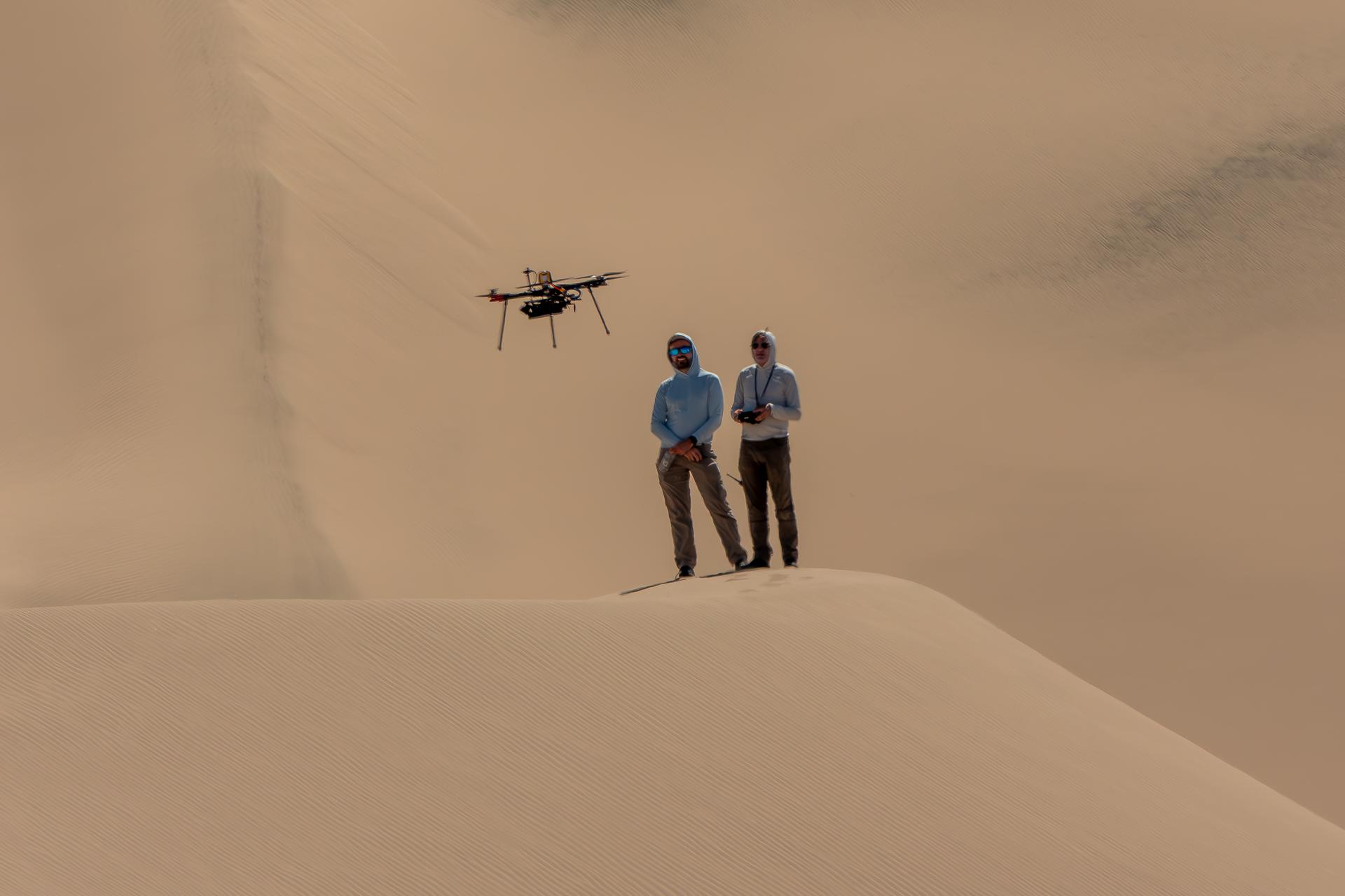
A researcher from NASA’s Jet Propulsion Laboratory in Southern California monitors a drone as it flies over sand dunes in September 2025. This image was captured in Death Valley National Park during a larger test campaign to develop navigation software that would guide future rotorcraft on Mars. The work was among 25 projects funded by NASA’s Mars Exploration Program this past year to push the limits of future technologies. Sand dunes confused the navigation algorithm of the Ingenuity Mars helicopter during several of its last flights, including its 72nd and final flight on the Red Planet in January 2024. The navigation software in development would help future rotorcraft track the surface of especially bland, featureless terrain similar to the barren sand dunes seen in parts of Death Valley. Tests also included flights over a region of the park called Mars Hill, which is littered with rubbly volcanic rocks and has been used by NASA’s Mars researchers since the 1970s, during preparations for the Viking lander missions.
![This is the first photograph ever taken on the surface of the planet Mars. It was obtained by Viking 1 just minutes after the spacecraft landed successfully early today [July 20, 1976]. The center of the image is about 1.4 meters (five feet) from Viking Lander camera #2. We see both rocks and finely granulated material--sand or dust. Many of the small foreground rocks are flat with angular facets. Several larger rocks exhibit irregular surfaces with pits and the large rock at top left shows intersecting linear cracks. Extending from that rock toward the camera is a vertical linear dark band which may be due to a one-minute partial obscuration of the landscape due to clouds or dust intervening between the sun and the surface. Associated with several of the rocks are apparent signs of wind transport of granular material. The large rock in the center is about 10 centimeters (4 inches) across and shows three rough facets. To its lower right is a rock near a smooth portion of the Martian surface probably composed of very fine-grained material. It is possible that the rock was moved during Viking 1 descent maneuvers, revealing the finer-grained basement substratum; or that the fine-grained material has accumulated adjacent to the rock. There are a number of other furrows and depressions and places with fine-grained material elsewhere in the picture. At right is a portion of footpad #2. Small quantities of fine grained sand and dust are seen at the center of the footpad near the strut and were deposited at landing. The shadow to the left of the footpad clearly exhibits detail, due to scattering of light either from the Martian atmosphere or from the spacecraft, observable because the Martian sky scatters light into shadowed areas. http://photojournal.jpl.nasa.gov/catalog/PIA00381](https://images-assets.nasa.gov/image/PIA00381/PIA00381~thumb.jpg)
This is the first photograph ever taken on the surface of the planet Mars. It was obtained by Viking 1 just minutes after the spacecraft landed successfully early today [July 20, 1976]. The center of the image is about 1.4 meters (five feet) from Viking Lander camera #2. We see both rocks and finely granulated material--sand or dust. Many of the small foreground rocks are flat with angular facets. Several larger rocks exhibit irregular surfaces with pits and the large rock at top left shows intersecting linear cracks. Extending from that rock toward the camera is a vertical linear dark band which may be due to a one-minute partial obscuration of the landscape due to clouds or dust intervening between the sun and the surface. Associated with several of the rocks are apparent signs of wind transport of granular material. The large rock in the center is about 10 centimeters (4 inches) across and shows three rough facets. To its lower right is a rock near a smooth portion of the Martian surface probably composed of very fine-grained material. It is possible that the rock was moved during Viking 1 descent maneuvers, revealing the finer-grained basement substratum; or that the fine-grained material has accumulated adjacent to the rock. There are a number of other furrows and depressions and places with fine-grained material elsewhere in the picture. At right is a portion of footpad #2. Small quantities of fine grained sand and dust are seen at the center of the footpad near the strut and were deposited at landing. The shadow to the left of the footpad clearly exhibits detail, due to scattering of light either from the Martian atmosphere or from the spacecraft, observable because the Martian sky scatters light into shadowed areas. http://photojournal.jpl.nasa.gov/catalog/PIA00381
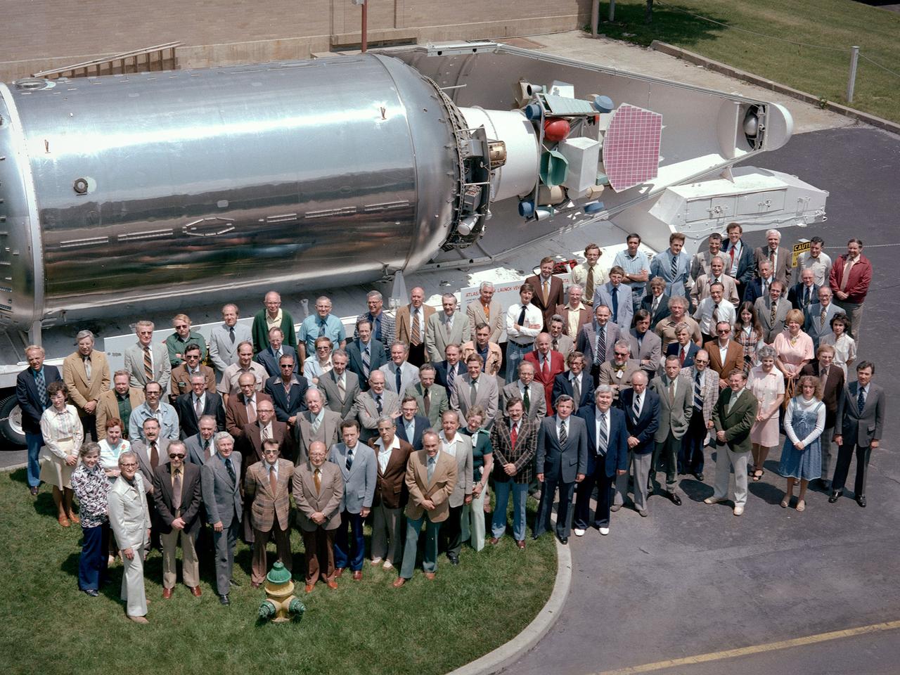
The National Aeronautics and Space Administration (NASA) Lewis Research Center’s Launch Vehicle Directorate in front of a full-scale model of the Centaur second-stage rocket. The photograph was taken to mark Centaur’s fiftieth launch. NASA Lewis managed the Centaur Program since 1962. At that time, the only prior launch attempt ended in failure. Lewis improved the spacecraft and tested it extensively throughout the early 1960s. In May 1966 an Atlas-Centaur sent the Surveyor spacecraft to the moon. It was the first successful soft landing on another planet. The Launch Vehicles Division was formed in 1969 to handle the increasing number of Centaur launches. The Lewis team became experts at integrating the payload with the Centaur and calculating proper trajectories for the missions. Centaur’s first 50 missions included Orbiting Astronomical Observatories, the Mariner 6 and 7 flybys of Mars, Mariner 9 which was the first spacecraft to orbit around another planet, the Pioneer 10 and 11 missions to the outer solar system, the Mariner 10 flyby of Venus and Mercury, the Viking 1 and 2 Mars landers, Voyagers 1 and 2 missions to Jupiter, Saturn, Uranus, and Neptune, and the Pioneer 12 and 13 flights to Venus.
Exterior view of the Space Power Facility at the National Aeronautics and Space Administration’s (NASA) Plum Brook Station in Sandusky, Ohio. The $28.4-million facility, which began operations in 1969, is the largest high vacuum chamber ever built. The chamber is 100 feet in diameter and 120 feet high. It produces a vacuum deep enough to simulate the conditions at 300 miles altitude. The facility can sustain a high vacuum; simulate solar radiation via a 4-megawatt quartz heat lamp array, solar spectrum by a 400-kilowatt arc lamp, and cold environments. The Space Power Facility was originally designed to test nuclear power sources for spacecraft during long durations in a space atmosphere, but it was never used for that purpose. The facility’s first test in 1970 involved a 15 to 20-kilowatt Brayton Cycle Power System for space applications. Three different methods of simulating solar heat were employed during the Brayton tests. The facility was also used for jettison tests of the Centaur Standard Shroud. The shroud was designed for the new Titan-Centaur rocket that was scheduled to launch the Viking spacecraft to Mars. The new shroud was tested under conditions that simulated the time from launch to the separation of the stages. Test programs at the facility include high-energy experiments, shroud separation tests, Mars Lander system tests, deployable Solar Sail tests and International Space Station hardware tests.
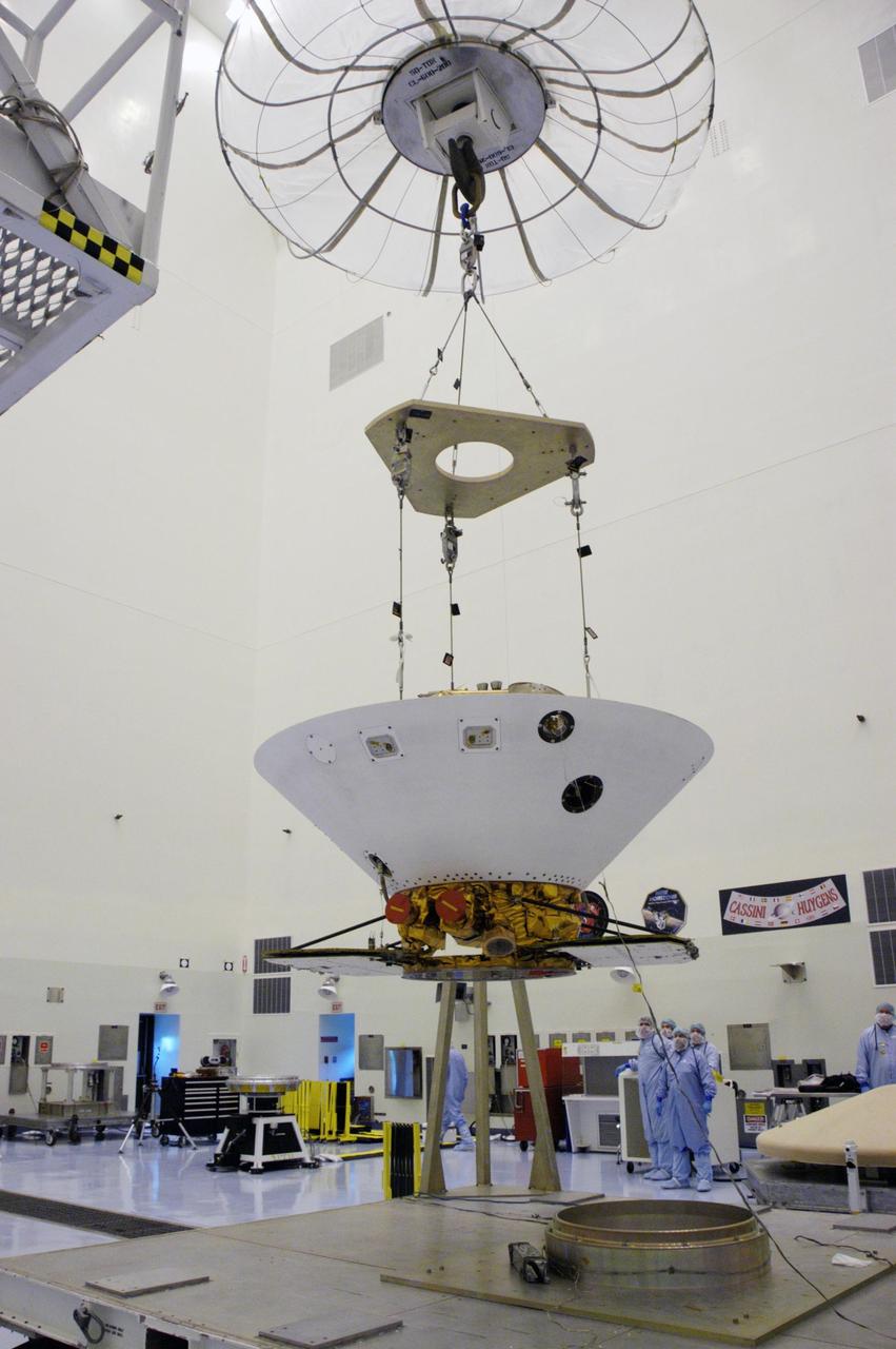
KENNEDY SPACE CENTER, FLA. -- An overhead crane lifts the backshell with the Phoenix Mars Lander inside off its work stand in the Payload Hazardous Servicing Facility. The spacecraft is being moved to a spin table (back left) for spin testing. The Phoenix mission is the first project in NASA's first openly competed program of Mars Scout missions. Phoenix will land in icy soils near the north polar permanent ice cap of Mars and explore the history of the water in these soils and any associated rocks, while monitoring polar climate. Landing is planned in May 2008 on arctic ground where a mission currently in orbit, Mars Odyssey, has detected high concentrations of ice just beneath the top layer of soil. It will serve as NASA's first exploration of a potential modern habitat on Mars and open the door to a renewed search for carbon-bearing compounds, last attempted with NASA’s Viking missions in the 1970s. A stereo color camera and a weather station will study the surrounding environment while the other instruments check excavated soil samples for water, organic chemicals and conditions that could indicate whether the site was ever hospitable to life. Microscopes can reveal features as small as one one-thousandth the width of a human hair. Launch of Phoenix aboard a Delta II rocket is targeted for Aug. 3 from Cape Canaveral Air Force Station in Florida. Photo credit: NASA/George Shelton
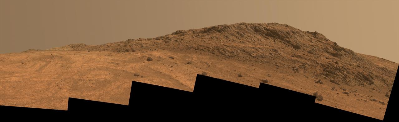
This Martian scene shows contrasting textures and colors of "Hinners Point," at the northern edge of "Marathon Valley," and swirling reddish zones on the valley floor to the left. The view combines six frames taken by the panoramic camera (Pancam) on NASA's Mars Exploration Rover Opportunity on Aug. 14, 2015, during the 4,108th Martian day, or sol, of the rover's work on Mars. The summit takes its informal name as a tribute to Noel Hinners (1935-2014). For NASA's Apollo program, Hinners played important roles in selection of landing sites on the moon and scientific training of astronauts. He then served as NASA associate administrator for space science, director of the Smithsonian National Air and Space Museum, director of NASA's Goddard Space Flight Center, NASA chief scientist and associate deputy administrator of NASA. Subsequent to responsibility for the Viking Mars missions while at NASA, he spent the latter part of his career as vice president for flight systems at Lockheed Martin, where he had responsibility for the company's roles in development and operation of NASA's Mars Global Surveyor, Mars Reconnaissance Orbiter, Mars Odyssey, Phoenix Mars Lander, Stardust and Genesis missions. Marathon Valley cuts generally east-west through the western rim of Endeavour Crater. The valley's name refers to the distance Opportunity drove from its 2004 landing site to arrival at this location in 2014. The valley was a high-priority destination for the rover mission because observations from orbit detected clay minerals there. Dark rocks on Hinners Point show a pattern dipping downward toward the interior of Endeavour, to the right from this viewing angle. The strong dip may have resulted from the violence of the impact event that excavated the crater. Brighter rocks make up the valley floor. The reddish zones there may be areas where water has altered composition. Inspections by Opportunity have found compositions there are higher in silica and lower in iron than the typical composition of rocks on Endeavour's rim. The scene spans from west-southwest at left to northwest at right. The larger of two stones close to each other in the foreground left of center is about 5 inches (12 centimeters) wide. On bright bedrock to the right of those stones, Opportunity inspected a target informally named "Pvt. George Gibson." Another inspected target, "Pvt. Silas Goodrich," is on the valley floor near the left edge of this scene. The informal names for these targets refer to members of the Lewis and Clark expedition's Corps of Discovery. This version of the image is presented in approximate true color by combing exposures taken through three of the Pancam's color filters, centered on wavelengths of 753 nanometers (near-infrared), 535 nanometers (green) and 432 nanometers (violet). http://photojournal.jpl.nasa.gov/catalog/PIA19819
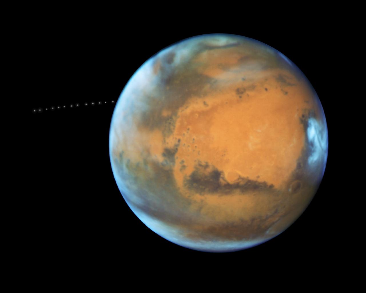
The sharp eye of NASA's Hubble Space Telescope has captured the tiny moon Phobos during its orbital trek around Mars. Because the moon is so small, it appears star-like in the Hubble pictures. Over the course of 22 minutes, Hubble took 13 separate exposures, allowing astronomers to create a time-lapse video showing the diminutive moon's orbital path. The Hubble observations were intended to photograph Mars, and the moon's cameo appearance was a bonus. A football-shaped object just 16.5 miles by 13.5 miles by 11 miles, Phobos is one of the smallest moons in the solar system. It is so tiny that it would fit comfortably inside the Washington, D.C. Beltway. The little moon completes an orbit in just 7 hours and 39 minutes, which is faster than Mars rotates. Rising in the Martian west, it runs three laps around the Red Planet in the course of one Martian day, which is about 24 hours and 40 minutes. It is the only natural satellite in the solar system that circles its planet in a time shorter than the parent planet's day. About two weeks after the Apollo 11 manned lunar landing on July 20, 1969, NASA's Mariner 7 flew by the Red Planet and took the first crude close-up snapshot of Phobos. On July 20, 1976 NASA's Viking 1 lander touched down on the Martian surface. A year later, its parent craft, the Viking 1 orbiter, took the first detailed photograph of Phobos, revealing a gaping crater from an impact that nearly shattered the moon. Phobos was discovered by Asaph Hall on August 17, 1877 at the U.S. Naval Observatory in Washington, D.C., six days after he found the smaller, outer moon, named Deimos. Hall was deliberately searching for Martian moons. Both moons are named after the sons of Ares, the Greek god of war, who was known as Mars in Roman mythology. Phobos (panic or fear) and Deimos (terror or dread) accompanied their father into battle. Close-up photos from Mars-orbiting spacecraft reveal that Phobos is apparently being torn apart by the gravitational pull of Mars. The moon is marred by long, shallow grooves that are probably caused by tidal interactions with its parent planet. Phobos draws nearer to Mars by about 6.5 feet every hundred years. Scientists predict that within 30 to 50 million years, it either will crash into the Red Planet or be torn to pieces and scattered as a ring around Mars. Orbiting 3,700 miles above the Martian surface, Phobos is closer to its parent planet than any other moon in the solar system. Despite its proximity, observers on Mars would see Phobos at just one-third the width of the full moon as seen from Earth. Conversely, someone standing on Phobos would see Mars dominating the horizon, enveloping a quarter of the sky. From the surface of Mars, Phobos can be seen eclipsing the sun. However, it is so tiny that it doesn't completely cover our host star. Transits of Phobos across the sun have been photographed by several Mars-faring spacecraft. The origin of Phobos and Deimos is still being debated. Scientists concluded that the two moons were made of the same material as asteroids. This composition and their irregular shapes led some astrophysicists to theorize that the Martian moons came from the asteroid belt. However, because of their stable, nearly circular orbits, other scientists doubt that the moons were born as asteroids. Such orbits are rare for captured objects, which tend to move erratically. An atmosphere could have slowed down Phobos and Deimos and settled them into their current orbits, but the Martian atmosphere is too thin to have circularized the orbits. Also, the moons are not as dense as members of the asteroid belt. Phobos may be a pile of rubble that is held together by a thin crust. It may have formed as dust and rocks encircling Mars were drawn together by gravity. Or, it may have experienced a more violent birth, where a large body smashing into Mars flung pieces skyward, and those pieces were brought together by gravity. Perhaps an existing moon was destroyed, reduced to the rubble that would become Phobos. Hubble took the images of Phobos orbiting the Red Planet on May 12, 2016, when Mars was 50 million miles from Earth. This was just a few days before the planet passed closer to Earth in its orbit than it had in the past 11 years. A time-lapse video captures a portion of the path that tiny Phobos takes around Mars. Over the course of 22 minutes, Hubble snapped 13 separate exposures of the little Martian moon. The video can be viewed at https://photojournal.jpl.nasa.gov/catalog/PIA21837
This Martian scene shows contrasting textures and colors of "Hinners Point," at the northern edge of "Marathon Valley," and swirling reddish zones on the valley floor to the left. In this version of the image, the landscape is presented in enhanced color to make differences in surface materials more easily visible. The summit takes its informal name as a tribute to Noel Hinners (1935-2014). For NASA's Apollo program, Hinners played important roles in selection of landing sites on the moon and scientific training of astronauts. He then served as NASA associate administrator for space science, director of the Smithsonian National Air and Space Museum, director of NASA's Goddard Space Flight Center, NASA chief scientist and associate deputy administrator of NASA. Subsequent to responsibility for the Viking Mars missions while at NASA, he spent the latter part of his career as vice president for flight systems at Lockheed Martin, where he had responsibility for the company's roles in development and operation of NASA's Mars Global Surveyor, Mars Reconnaissance Orbiter, Mars Odyssey, Phoenix Mars Lander, Stardust and Genesis missions. Marathon Valley cuts generally east-west through the western rim of Endeavour Crater. The valley's name refers to the distance Opportunity drove from its 2004 landing site to arrival at this location in 2014. The valley was a high-priority destination for the rover mission because observations from orbit detected clay minerals there. Dark rocks on Hinners Point show a pattern dipping downward toward the interior of Endeavour, to the right from this viewing angle. The strong dip may have resulted from the violence of the impact event that excavated the crater. Brighter rocks make up the valley floor. The reddish zones there may be areas where water has altered composition. Inspections by Opportunity have found compositions there are higher in silica and lower in iron than the typical composition of rocks on Endeavour's rim. The scene spans from west-southwest at left to northwest at right. The larger of two stones close to each other in the foreground left of center is about 5 inches (12 centimeters) wide. On bright bedrock to the right of those stones, Opportunity inspected a target informally named "Pvt. George Gibson." Another inspected target, "Pvt. Silas Goodrich," is on the valley floor near the left edge of this scene. The informal names for these targets refer to members of the Lewis and Clark expedition's Corps of Discovery. The image combines exposures taken through three of the Pancam's color filters, centered on wavelengths of 753 nanometers (near-infrared), 535 nanometers (green) and 432 nanometers (violet). http://photojournal.jpl.nasa.gov/catalog/PIA19820
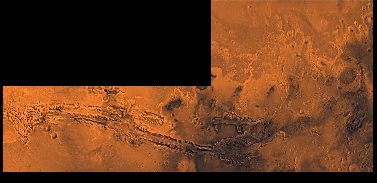
A color image of Valles Marineris, the great canyon and the south Chryse basin-Valles Marineris outflow channels of Mars; north toward top. The scene shows the entire Valles Marineris canyon system, over 3,000 km long and averaging 8 km deep, extending from Noctis Labyrinthus, the arcuate system of graben to the west, to the chaotic terrain to the east and related outflow canyons that drain toward the Chryse basin. Eos and Capri Chasmata (south to north) are two canyons connected to Valles Marineris. Ganges Chasma lies directly north. The chaos in the southeast part of the image gives rise to several outflow channels, Shalbatana, Simud, Tiu, and Ares Valles (left to right), that drained north into the Chryse basin. The mouth of Ares Valles is the site of the Mars Pathfinder lander. This image is a composite of Viking medium-resolution images in black and white and low-resolution images in color; Mercator projection. The image roughly extends from latitude 20 degrees S. to 20 degrees N. and from longitude 15 degrees to 102.5 degrees. The connected chasma or valleys of Valles Marineris may have formed from a combination of erosional collapse and structural activity. Layers of material in the eastern canyons might consist of carbonates deposited in ancient lakes, eolian deposits, or volcanic materials. Huge ancient river channels began from Valles Marineris and from adjacent canyons and ran north. Many of the channels flowed north into Chryse Basin. The south Chryse outflow channels are cut an average of 1 km into the cratered highland terrain. This terrain is about 9 km above datum near Valles Marineris and steadily decreases in elevation to 1 km below datum in the Chryse basin. Shalbatana is relatively narrow (10 km wide) but can reach 3 km in depth. The channel begins at a 2- to 3-km-deep circular depression within a large impact crater, whose floor is partly covered by chaotic material, and ends in Simud Valles. Tiu and Simud Valles consist of a complex of connected channel floors and chaotic terrain and extend as far south as and connect to eastern Valles Marineris. Ares Vallis originates from discontinuous patches of chaotic terrain within large craters. In the Chryse basin the Ares channel forks; one branch continues northwest into central Chryse Planitia and the other extends north into eastern Chryse Planitia. http://photojournal.jpl.nasa.gov/catalog/PIA00426

B-57B on ramp
B-57B in flight